

1. MPA Assessment
1.1. Introduction
1.1. Introduction
- Berwick Bank Wind Farm Limited (BBWFL) is a wholly owned subsidiary of SSE Renewables Limited and will hereafter be referred to as ‘the Applicant’.
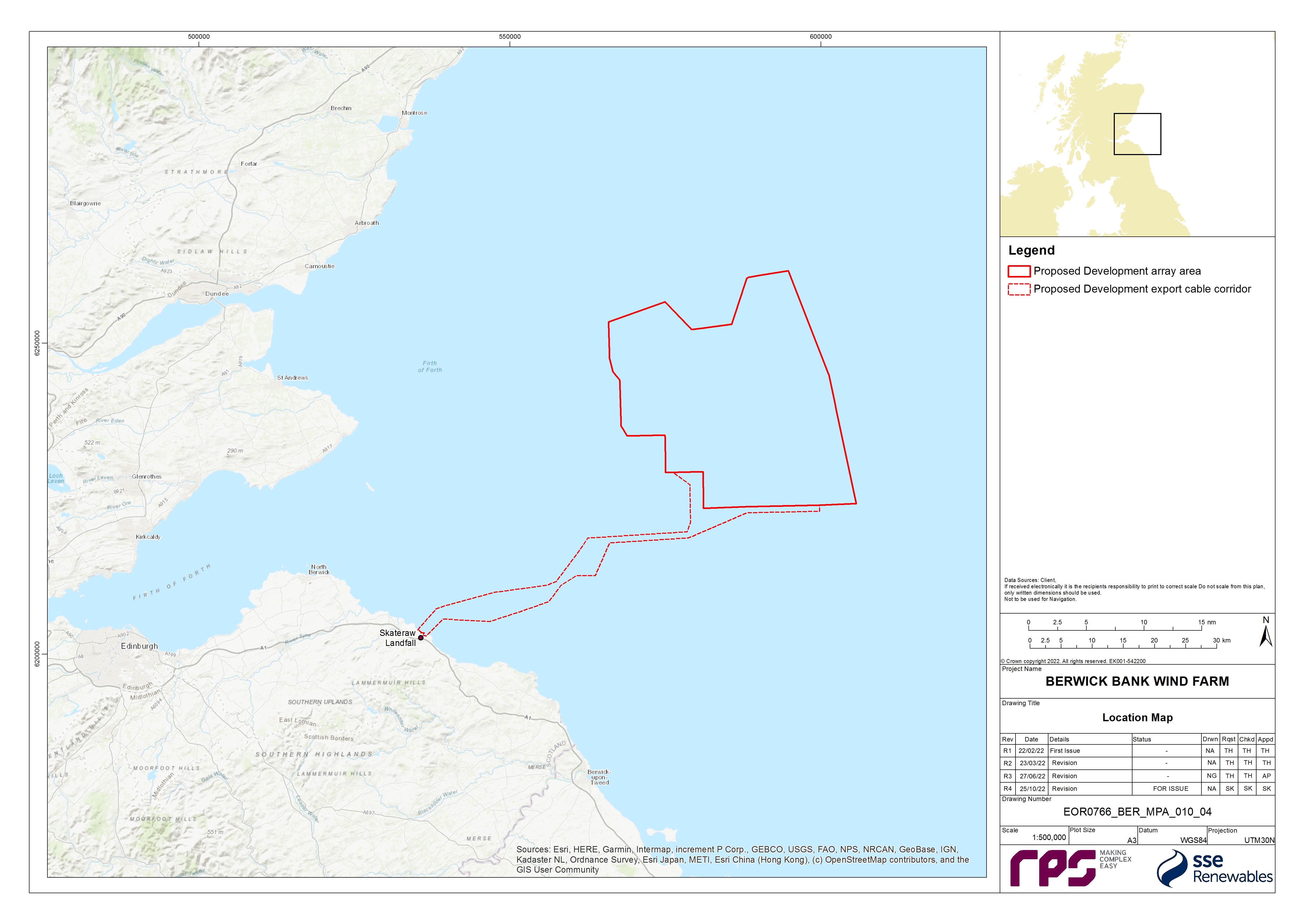
- The Applicant is developing the Berwick Bank Wind Farm (hereafter referred to as ‘the Project’). The Project is an offshore wind farm project located in the outer Firth of Forth and Firth of Tay, approximately 37.8 km east of the Scottish Borders coastline (St. Abb’s Head) and 47.6 km to the East Lothian coastline, in the southern region of the North Sea (Figure 1.1).
- The Project is comprised of both the offshore and onshore infrastructure required to generate and transmit electricity from the offshore components of the Project (hereafter referred to as the ‘Proposed Development’) array area to a Scottish Power Transmission (SPT) 400 kV Grid Substation located at Branxton, south-east of Torness Power station. The Proposed Development export cable corridor will make landfall on the East Lothian coast, specifically at Skateraw. The offshore components (the Proposed Development) include the offshore wind farm (the wind turbines, their foundations and associated inter-array cabling), together with associated infrastructure of the Offshore Transmission Asset (OTA), Offshore Substation Platforms (OSPs)/Offshore convertor station platforms, their foundations and the offshore export cables and cable protection.
- The Applicant is also developing an additional export cable grid connection to Blyth, Northumberland (the Cambois connection). Applications for necessary consents (including marine licences) will be applied for separately. The Cumulative Effects Assessment (CEA) of the Cambois connection is based on information presented in the Cambois connection Scoping Report (SSER, 2022e), submitted in October 2022.
- RPS Energy Limited (RPS) was commissioned to undertake a Marine Protected Area (MPA) assessment for the Proposed Development and this document provides the final MPA Assessment to accompany the Proposed Development Offshore EIA Report. It is intended that this document, alongside the Offshore EIA Report, will be used to inform an MPA assessment undertaken by Scottish Ministers.
1.2. Purpose of this Report
1.2. Purpose of this Report
- Specific consideration of MPAs[1] is required for consent applications in UK waters. Under section 126 of the Marine and Coastal Access Act 2009, and section 83 of the Marine (Scotland) Act 2010, public authorities (in this case Marine Scotland - Licensing Operations Team (MS-LOT) on behalf of the Scottish Ministers) have specific duties for MPAs in relation to certain decisions. The public authority is required to consider whether the activity which is the subject of the application (i.e. marine licensable activities subject to a marine licence application) are capable of affecting (other than insignificantly) a protected feature in a Nature Conservation (nc) MPA or any ecological or geomorphological process on which the conservation of any protected feature in a ncMPA (hereafter referred to as an MPA) is dependant. MS-LOT must not grant authorisation of the activity unless the person applying for the authorisation satisfies MS-LOT that there is no significant risk of the activity hindering the achievement of the conservation objectives for the MPA. If the person seeking the authorisation is not able to satisfy MS-LOT that there is no significant risk of the activity hindering the achievement of the conservation objectives, then the authorisation must only be granted if:
- MS-LOT is satisfied that there are no other means of proceeding with the activity which would create a substantially lower risk of hindering the achievement of those objectives (to include proceeding in another manner or at another location);
- MS-LOT is satisfied that the benefit to the public of proceeding with the activity clearly outweighs the risk of damage to the environment that will be created by proceeding with it; and
- MS-LOT is satisfied that the person seeking the authorisation will undertake, or make arrangements for the undertaking of, measures of equivalent environmental benefit to the damage which the activity will or is likely to have in or on the MPA concerned.
- This report has been produced to provide evidence on whether the potential impacts of the Proposed Development give rise to a significant risk of hindering the conservation objectives of any MPA which may be screened in.
- This document is informed by guidance published by Marine Scotland (2014a) on how these assessments should be undertaken and by advice from the Statutory Nature Conservation Bodies (SNCBs) during consultation in the pre-application phase (as outlined in section 1.2.2). This MPA Assessment has been undertaken based on the Proposed Development information detailed within volume 1, chapter 3 of the Offshore EIA Report and section 1.4 of this report.
- This MPA Assessment should be read alongside the following chapters of the Offshore EIA Report, all of which have been drawn upon and referred to throughout this document:
- volume 2, chapter 7: Physical Processes;
- volume 2, chapter 8: Benthic Subtidal and Intertidal Ecology;
- volume 3, appendix 8.1: Benthic Subtidal and Intertidal Ecology Technical Report;
- volume 2, chapter 9: Fish and Shellfish;
- volume 3, appendix 6.1: Scoping Report; and
- volume 3, appendix 6.2: Scoping Opinion.
- This report is structured as follows:
- section 1.1: Introduction;
- section 1.3: Methodology, including description of the staged approach to the MPA Assessment following the relevant published guidelines, and how information presented in the Offshore EIA Report has been used to support the assessments presented herein;
- section 1.4: Project description, provides an outline description of the Proposed Development and describes the activities likely to be associated with the construction, operation, and maintenance, and decommissioning of the Proposed Development;
- section 1.4.3: Initial screening of MPAs which have conservation objectives with the potential to be affected by the Proposed Development;
- section 1.6: Background information on MPAs considered in the main assessment;
- section 1.7: Main assessment;
- section 1.8: Conclusion; and
- section 1.9: Summary.
1.2.2. Consultation
- This MPA Assessment has been informed by consultation with key stakeholders, including Marine Scotland Science (MSS), MS-LOT and NatureScot, through the scoping process and through the Benthic Ecology, Fish and Shellfish Ecology, and Physical Processes Road Map process. A summary of the key issues raised during pre-application consultation is outlined in Table 1.1 Open ▸ , together with how these issues have been considered in the production of this report.
![]()
Table 1.1: Summary of Key Consultation Issues Raised During Pre-Application Consultation Activities Undertaken of Relevance to the MPA Assessment
1.3. Methodology
1.3. Methodology
- The Marine (Scotland) Act 2010 and the Marine and Coastal Access Act 2009 introduced provisions to support the management of MPAs. Under section 126 of the Marine and Coastal Access Act 2009 and section 83 of the Marine (Scotland) Act 2010, the public authority (MS-LOT) is required, when determining consenting application, to consider whether the activity applied for is capable of affecting (other than insignificantly) a protected feature in an MPA or any ecological or geomorphological process on which the conservation of any protected feature in an MPA is dependant.
- It was highlighted by MS-LOT and NatureScot in the Berwick Bank Wind Farm Scoping Opinion (MS-LOT, 2022) that the Offshore EIA Report must make a full and clear assessment of the potential impacts of the Proposed Development on all the designated features of any scoped in MPA. The Applicant confirmed during a Benthic Ecology, Fish and Shellfish Ecology and Physical Processes Road Map meeting (Meeting 1) on 3 September 2021 that this would be presented as a separate standalone document alongside the Offshore EIA Report.
- Marine Scotland’s Nature Conservation Marine Protected Areas: Draft Management Handbook (Marine Scotland, 2014a) recommends a staged approach to the assessment, starting with an initial screening process which should focus on what can reasonably be predicted as a consequence of the proposal and whether it is ‘capable of affecting (other than insignificantly)’ a protected feature of an MPA. This should then be followed by a main assessment which focuses on determining whether the exercise of a function would or might significantly hinder, or there is or may be a significant risk of the act hindering, the achievement of the conservation objectives. Full details of each of these stages of the approach have been provided in sections 1.3.2 and 1.3.3, respectively.
- If certain activities, sites or impacts are screened into the MPA Assessment process, these are then considered within the main assessment if significant risks to the achievement of the MPA conservation objectives have been identified by the initial screening.
1.3.2. Initial Screening
- Marine Scotland’s Nature Conservation Marine Protected Areas: Draft Management Handbook (Marine Scotland, 2014a) states that the initial screening stage should focus on what can reasonably be predicted as a consequence of the proposal and whether it is ‘capable of affecting (other than insignificantly)’ a protected feature of an MPA. The screening should use information that is currently available on the activities applied for and consider aspects such as the scale, timing and duration of proposed activities/developments. These considerations should include proposals for developments or activities out-with the boundary of an MPA.
- Firstly, consideration of ‘capable of affecting’ should result in removing from further consideration all proposals/functions which are not in any way connected to the protected feature(s). A capability that is both remote (in terms of likelihood of occurrence) and hypothetical should not be the basis of a conclusion that further assessment is required. This can be determined by considering whether the activity will exert pressures which the protected feature(s) are sensitive to (Marine Scotland, 2014a). Generic guidance and evidence on activities which exert pressures on the protected features is available through the online Feature Activity Sensitivity Tool (FeAST) sensitivity tool.
- Secondly, if the conclusion is that there is ‘capability of affecting’, the focus should then be on considering whether the activity will affect the protected features of an MPA, other than insignificantly. Consideration of the degree of pressure that could be exerted by the activity on a spatial basis should help to establish what level of effect might occur. Where it is concluded that the act or function is capable of affecting (other than insignificantly) the protected features of an MPA then a main assessment must be carried out considering the conservation objectives.
- In order to determine the ‘nearness’ of the activities associated with the Proposed Development for the purposes of this MPA Assessment, the same screening criteria as used for the Berwick Bank Habitats Regulations Appraisal (HRA) Offshore Screening Report (SSER, 2021b) were applied. These initial assumptions have subsequently been validated and refined through consultation with the SNCBs throughout the pre-application process (i.e. via the Benthic Ecology, Fish and Shellfish and Physical Processes Road Map process; see Table 1.1 Open ▸ ). These are as follows for the different protected features of MPAs:
- Benthic habitats/species and geodiversity features: there is the potential for indirect effects to sites designated for benthic features, as well as geodiversity features, as a result of impacts associated with increased suspended sediment concentrations (SSC) arising from construction activities or from changes to the hydrodynamic regime as a result of the presence of offshore infrastructure associated with the Proposed Development. The extent of these impacts is considered likely to extend beyond the boundaries of the Proposed Development. The zone of influence (ZOI) for such indirect effects is typically defined from the outputs of physical processes modelling to determine, for example, the fate of sediments resuspended during the construction process. Physical processes modelling had not been carried out at the Scoping stage. Therefore, a buffer of one mean tidal excursion was used initially to inform this area, with a reasonable level of precaution applied. One mean tidal excursion in the vicinity of the Proposed Development equates to approximately 6.5 km, as derived from the Atlas of UK Marine Renewable Energy Resources (ABPmer, 2008). For the purposes of MPA screening, a precautionary was adopted and this buffer was increased to 20 km. This buffer is considered to be sufficiently precautionary to capture all sites likely to be in the ZOI from direct and indirect effects associated with construction activities. This buffer has also been applied for geodiversity features of MPAs;
- Fish species: the HRA screening does not propose a screening distance for fish, as all European sites with diadromous fish species with the potential to be affected have been considered. For the purposes of this MPA Assessment (which does not consider diadromous fish, only marine fish) a nominal buffer of 100 km has been adopted to screen in MPA sites with fish features (e.g. sandeel species), on the basis that this is sufficiently precautionary to capture the ZOI from the project from key impacts such as underwater noise;
- Marine mammals: the HRA screening considers sites with cetaceans as qualifying interest features within a buffer that equates to the regional marine mammal study areas. For seals, all sites within the East Scotland Management Unit (MU) have been considered. These buffers are considered to be sufficiently precautionary to capture all sites likely to be in the ZOI from indirect effects associated with construction activities; and
- Ornithology: the HRA screening considers sites with breeding seabirds as qualifying interest features within a buffer that equates to the offshore ornithological regional study area. Published mean-maximum foraging ranges (plus one standard deviation (+1 S.D.)) in Woodward et al. (2019) were used to define the offshore ornithology regional study area. Northern gannet Morus bassanus has the largest foraging range (315.2 km ± 194.2 km) of the key species considered in the ornithology assessment. The offshore ornithology regional study area therefore extends 509.4 km from the Proposed Development. For seabirds in the non-breeding season, the ZOI is based on Furness (2015) which presents Biologically Defined Minimum Population Scales (BDMPS). These buffers are considered to be sufficiently precautionary to capture all sites likely to be in the ZOI from indirect effects associated with construction and operational activities. Following the establishment of the screening criteria and in view of the outputs of the collision risk, displacement and Population Viability Analysis assessments (volume 3, appendix 11.3 and appendix 11.6 of the Offshore EIA Report) the buffers have been refined and it was determined that no sites are likely to be in the ZOI in relation to ornithology.
- Additionally since Scoping, the assumptions applied for the MPA screening have been revisited in view of the outputs of the physical processes modelling undertaken for the Proposed Development (as reported in full in volume 2, chapter 7 of the Offshore EIA Report and volume 3, appendix 7.1 of the Offshore EIA Report). This modelling found that there would be no changes in tidal currents or sediment transport that would extend to the border of the 20 km study area and would further not disrupt beach and offshore bank morphological processes or destabilise coastal features. It is therefore concluded that the buffer applied is sufficiently precautionary to ensure all of the potentially affected benthic ecology receptors have been taken account of.
- The screening criteria applied however will depend in the nature of the MPA for example should none of the MPAs within the ZOI for the Proposed Development have seabirds as a qualifying feature then the ornithology screening criteria becomes redundant and will be screened out.
- Following identification of the MPAs considered in this initial screening, information presented within the Berwick Bank Wind Farm Scoping Opinion (MS-LOT, 2022) and the Offshore EIA Report has been reviewed to further refine this list of sites where the Proposed Development is capable of significantly affecting the protected/proposed features of those sites, or any ecological or geomorphological processes on which the conservation objectives of those features may depend. This included advice provided by the SNCBs and regulators on which sites should be included in the MPA Assessment as well as a review of outputs from volume 2, chapter 7 of the Offshore EIA Report to identify potential far field effects (e.g. increases in SSC, and changes to the tidal and wave regime due to the operational Proposed Development). Where robust evidence is available to screen out MPAs, this evidence has been referenced and justification presented within section 1.4.3.
- Individual impacts on designated protected features of the MPAs are also considered in the screening. Some impacts identified and assessed in volume 2, chapter 8 of the Offshore EIA Report were considered to be of sufficiently low risk of resulting in a likely significant effect on protected/proposed MPA features and have therefore been screened out (i.e. are considered insignificant). This may have been due, for example, to the extremely limited extent and/or duration of the impact, a lack of sensitivity of the receptors to the impact (as determined through the FeAST sensitivity tool or from the Advice on Operations Guidance documents), or due to control measures to be implemented by the Proposed Development to minimise the risk of any likely significant effect occurring. This is consistent with the guidance provided in Marine Scotland’s Nature Conservation Marine Protected Areas: Draft Management Handbook (Marine Scotland, 2014a).
1.3.3. Main Assessment
- The main assessment stage focuses on determining whether the exercise of a function would or might significantly hinder, or there is or may be a significant risk of the act hindering, the achievement of the conservation objectives of the MPA.
- In doing so, the Marine Scotland (2014a) guidelines suggest the decision-maker would use the information supplied by the applicant along with the licence application, advice from the SNCBs and any other relevant information to determine whether there is no significant risk of hindering the achievement of the stated conservation objectives for the Nature Conservation MPA. Aspects such as scale, timing and duration of the proposed activities or developments will all need to be considered. However, whilst the initial screening focuses on the protected features, the main assessment focuses on the potential impact on the achievement of the conservation objectives of the protected features. Therefore, this stage must also include consideration of the scale of the potential impact. Consideration of cumulative effects with other activities and functions should also be undertaken.
- In determining 'significant risk of hindering', the Marine Scotland (2014a) guidance states “The assessment should build on the initial screening assessment that considers the pressures associated with the activity and the sensitivity of the protected features, and information on the likely spatial overlap. To determine whether there is a 'significant risk of hindering' the achievement of the conservation objectives of the protected features of a nature conservation MPA aspects such as the intensity, frequency, and duration of any activities associated with the function or act should be considered.” This approach is presented in the Proposed Development interpretation of the Marine Scotland (2014a) guidance as outlined in the following section.
- If MS-LOT determines that there is or may be a significant risk of the proposal hindering the achievement of the conservation objectives, then they must notify the appropriate statutory conservation bodies (NatureScot for MPAs within 12 nautical miles (nm) or the Joint Nature Conservation Committee (JNCC) for MPAs out with 12 nm) of that fact.
- In those circumstances, in order to grant consent MS-LOT must determine that:
- there is no other means of proceeding with the project which would create a substantially lower risk of hindering the achievement of those objectives;
- the benefit to the public of proceeding with the project clearly outweighs the risk of damage to the environment that will be created by proceeding with it; and
- the person seeking the authorisation will undertake, or make arrangements for the undertaking of, measures of equivalent environmental benefit to the damage which the project will or is likely to have in or on the MPA concerned.
- When considering whether an activity may hinder the conservation objectives of a site, consideration should be given to the direct impact of an activity upon a protected feature as well as any applicable indirect impacts. Such an indirect impact could include changing the effectiveness of a management measure put in place to further the conservation objectives.
Assessment of risk to conservation objectives
- Volume 2, chapter 7 and chapter 8 of the Offshore EIA Report have presented assessments of the impacts of the Proposed Development on the physical and biological marine environment respectively, with definitions of impact, effect, and significance of effects on the identified receptors (including protected features of MPA) drawn from guidelines published in the Design Manual for Roads and Bridges (DMRB) (Highways Agency, 2020). These definitions have also been used within this MPA Assessment, with the term 'effect' to express the consequence of an impact. This is expressed as the 'significance of effect' and is determined by considering the magnitude of the impact alongside the importance, or sensitivity, of the receptor or resource, in accordance with defined significance criteria.
- Volume 2, chapter 8 of the Offshore EIA Report presents significance levels according to EIA/Ecological Impact Assessment (EcIA) methodologies. While this MPA Assessment will draw on the information presented in volume 2, chapter 8 of the Offshore EIA Report to support the conclusions made about effects of the Proposed Development on the achievement of conservation objectives for the relevant MPA, the EIA/EcIA approach has not been used to inform the conclusions made.
- As discussed in section 1.3.3, the main assessment has considered whether there is a risk that the Proposed Development could hinder the achievement of the conservation status of protected features and conservation objectives for the MPA. This includes assessing the risks in the context of the conservation status of each of the individual MPA protected features.
- The conservation objectives are detailed in section 1.6 for the sites and the protected features which have been considered in the main assessment. For the Firth of Forth Banks Complex MPA, further information on the conservation objectives for each of the protected features was available in the Supplementary Advice on Conservation Objectives for the site (JNCC, 2018a). The Supplementary Advice presents attributes, and sub-attributes, which describe the ecological characteristics of the protected features. The attributes each have an objective(s) which is either quantitative or qualitative, depending on the available evidence. The objective identifies the desired state to be achieved for the attribute and an objective of recover or conserve is set for each feature attribute.
- The main assessment considers each of the attributes for all protected features of the relevant MPA, where there is a clear impact-receptor pathway, to help determine whether there is a significant risk to the conservation objectives of the MPA. This draws on information presented within the relevant chapters of the Offshore EIA Report (see paragraph 9). When considering ecological attributes, the sensitivities of the species and communities (often represented by biotopes; see section 1.6.2) associated with the MPA features have been defined by the following, according to the Marine Evidence based Sensitivity Assessment (MarESA) (OSPAR, 2008; Laffoley et al., 2000):
- Intolerance or resistance, which is the likelihood of damage due to a pressure; and
- Recoverability or resilience, which is the rate of (or time taken for) recovery once the pressure has abated or been removed. Recoverability is the ability of a habitat to return to the state before the activity or event which caused change. It is dependent on its ability to recover or recruit subject to the extent of disturbance/damage incurred. Full recovery does not necessarily mean that every component species has returned to its prior condition, abundance or extent but that the relevant functional components are present, and the habitat is structurally and functionally recognisable as the initial habitat of interest.
- The FeAST tool allows users to investigate the sensitivity of marine features in Scotland's seas to pressures arising from human activities. This tool also bases its definition of sensitivity upon the features tolerance/intolerance as well as its recoverability (Marine Scotland, 2013). As these features are all located in Scottish waters both MarESA and FeAST were used to determine the sensitivity of protected features.
- Therefore, where sensitivity levels have been presented within the main assessment of this document, these are the definitions according to the MarESA and FeAST (Tillin et al., 2010) and not according to the definitions used to inform the EIA in volume 2, chapter 8 of the Offshore EIA Report, the latter also considering the importance (e.g. conservation, commercial or ecological) of the receptors. Use of the MarESA and FeAST definitions also ensures consistency with the JNCCs conservation advice for the Firth of Forth Banks Complex MPA and other MPAs. Information on these aspects of sensitivity of the species, communities, and biotopes to given impacts has been informed by the best available evidence following environmental impact or experimental manipulation in the field and evidence from the offshore wind industry and analogous activities such as those associated with cable installation and operations, aggregate extraction and oil and gas industries. Where applicable, MarESA and FeAST have also been drawn upon to support the assessments of sensitivity, including evidence of sensitivity to particular activities and benchmarks for the relevant pressures considered for each attribute.
- Following consideration of the relevant impacts of the Proposed Development on attributes and targets of the individual MPA features, conclusions are presented as to the potential risks of the activities associated with the Proposed Development hindering achievement of conservation objectives for the sites and consequently whether the conditions in section 126 of the Marine and Coastal Access Act 2009 and section 83 of the Marine (Scotland) Act 2010 can be met (see paragraphs 24 and 26) (i.e. there is no significant risk of the activity hindering the achievement of the conservation objectives stated for the MPA).
- If it cannot be concluded that there is no significant risk of the activity hindering the achievement of the conservation objectives of an MPA, and that mitigation or consideration of alternative means of proceeding, would not create a substantially lower risk of hindering achievement of the conservation objectives (see paragraph 28), the Applicant must undertake, or make arrangements for the undertaking of, measures of equivalent environmental benefit to the damage which the project will or is likely to have in or on the MPA concerned. The assessment outcomes presented within this MPA Assessment demonstrate that there is no significant risk of the Proposed Development hindering the achievement of the conservation objectives of an MPA (see section 1.7), and so these latter stages are not relevant.
1.4. Project description
1.4. Project description
- This section provides an outline description of the Proposed Development and describes the activities likely to be associated with the construction, operation, and maintenance, and decommissioning of the Proposed Development. It summarises the design and components of the Proposed Development infrastructure, based on design concept and current understanding of the environment associated with the Proposed Development from site specific survey work.
- The Project Design Envelope (PDE) approach has been adopted for the assessment of the Proposed Development, which allows for a project to be assessed on the basis of maximum project design parameters. This provides flexibility, while ensuring all potential likely significant effects (positive or negative) are assessed. Those parameters presented include a range of potential values up to and including the maximum project design parameters.
- The Proposed Development will be located in the central North Sea, 43 km offshore of the East Lothian coastline and 33.5 km from the Scottish Borders coastline at St, Abbs. The Proposed Development is already the subject of Agreements for Lease (AfL). The Proposed Development operational lifetime is 35 years.
- The Proposed Development encompasses the:
- Proposed Development array area: This is where the offshore wind farm will be located, which will include the wind turbines, wind turbine foundations, inter-array cables, and a range of offshore substations and offshore interconnector cables; and
- Proposed Development export cable corridor up to mean high water springs (MHWS): This is where the offshore electrical infrastructure such as offshore export cables will be located.
1.4.2. Offshore Infrastructure
Overview
- The key offshore components of the Proposed Development (seaward of MHWS), as shown in Figure 1.2 Open ▸ , will include:
- up to 307 wind turbines (each comprising a tower section, nacelle and three rotor blades) and associated support structures and foundations;
- up to ten Offshore Substation Platforms (OSPs)/Offshore convertor station platforms and associated support structures and foundations to accommodate for a combined High Voltage Alternating Current (HVAC)/High Voltage Direct Current (HVDC) transmission system solution or a HVDC solution;
- estimated scour protection of up to 10,984 m2 per wind turbine and 11,146 m2 per OSP/Offshore convertor station platforms;
- a network of inter-array cabling linking the individual wind turbines to each other and to the OSPs/Offshore convertor station platforms plus inter-connections between OSPs/Offshore convertor station platforms (approximately 1,225 km of inter-array cabling and 94 km of interconnector cabling); and
- up to eight offshore export cables connecting the OSPs/Offshore convertor station platforms to landfall at Skateraw. Offshore export cables design includes both HVAC and HVDC solutions.
- The Applicant is also developing an additional export cable and grid connection to Blyth, Northumberland (hereafter the “Cambois connection”). Applications for the necessary consents (including marine licences) will be applied for separately once further development work has been undertaken on this offshore export corridor. The Cambois connection has been included as a cumulative project for the purposes of the offshore EIA and assessed based on the information presented in the Cambois connection Scoping Report submitted in October 2022 (SSER, 2022e). An EIA and HRA will be prepared to support any relevant consent applications that are required to deliver the Cambois connection which will also consider cumulative effects with the Proposed Development.
Figure 1.2: Project Overview[3]
Wind turbines
- The Proposed Development will comprise up to 307 wind turbines, with the final number of wind turbines dependent on the capacity of individual wind turbines used, and also environmental and engineering survey results. The PDE considers a range of wind turbines with parameters reflective of potential generating capacities, allowing for a degree of flexibility to account for any anticipated developments in wind turbine technology while still allowing each of the impacts assessed within the technical assessments (volume 2, chapters 7 to 21), to define the maximum design scenario for the assessment of effects. Consent is therefore sought for the physical parameters of the wind turbines which form the basis of the maximum design scenario such as maximum tip height or rotor diameter, as presented in the PDE rather than actual installed capacity of the wind turbines.
- A range of wind turbine options have been considered. The parameters in Table 1.2 Open ▸ provide for both the maximum number of wind turbines, as well as the largest wind turbine within the PDE. As set out in paragraph 1.2.8, the coupling of these maximum dimensions will not provide a realistic design scenario; as a reduced number of wind turbines will likely be required if an increased rated output of wind turbine model is chosen.
- The wind turbines will comprise a horizontal axis rotor with three blades connected to the nacelle of the wind turbine. Figure 1.3 Open ▸ illustrates a schematic of a typical offshore wind turbine.
Figure 1.3: Indicative Schematic of an Offshore Wind Turbine on a Jacket Foundation
- The maximum rotor blade diameter will be no greater than 310 m, with a maximum blade tip height of 355 m above LAT and a minimum lower blade tip height of 37 m above LAT. A scheme for wind turbine lighting and navigation marking will be approved by Scottish Ministers following consultation with appropriate consultees post consent. Outlines plans have been provided with the Application in volume 4 of this Offshore EIA Report.
- The layout of the wind turbines will be developed to best utilise both the available wind resource, suitability of seabed conditions and wake effects, while seeking to minimise environmental effects and impacts on other marine users (such as fisheries and shipping routes).
- Figure 1.4 Open ▸ presents an indicative wind farm layout based on the maximum design scenario of 307 wind turbines, while Figure 1.5 Open ▸ displays an indicative wind farm layout should 179 wind turbines were to be installed. The final layout of the wind turbines will be confirmed at the final design stage post consent with details being submitted to Marine Scotland Licensing Team (MS-LOT) for approval.
Table 1.2: Design Envelope: Wind Turbines
Figure 1.4: Berwick Bank Wind Farm Preliminary Indicative Layout for 307 Wind Turbines Each Square Being 5 km x 5 km)
Figure 1.5: Berwick Bank Wind Farm Preliminary Indicative Layout for 179 Wind Turbines Each Square Being 5 km x 5 km)
- grease;
- synthetic oil;
- hydraulic oil;
- gear oil;
- lubricants;
- nitrogen;
- water/glycerol;
- transformer silicon/ester oil;
- diesel fuel;
- sulphur hexafluoride SF6; and
- glycol/coolants
Wind turbine foundations and support structures
- To allow for flexibility in foundation choice, two types of wind turbine support structures and foundations are being considered for the Proposed Development:
- piled jacket; and
- suction caisson jacket.
- Foundations will be fabricated offsite, stored at a suitable port facility (if required) and transported to site by sea. Specialist vessels will transport and install foundations. Scour protection (typically rock) may be required on the seabed and will be installed before and/or after foundation installation. The following section provides an overview of the foundation types which are being considered for wind turbines - foundation structures for OSPs/Offshore convertor station platforms are discussed in paragraph 58 and seq.
Piled jacket foundation
- The piled jacket foundations will be transported to site by sea. Once at site, the jacket foundation will be lifted by the installation vessel using a crane and lowered towards the seabed in a controlled manner. Piled jacket foundations are formed of a steel lattice construction (comprising tubular steel members and welded joints) secured to the seabed by driven and/or drilled pin piles attached to the jacket feet (as illustrated in Figure 1.6 Open ▸ ). The hollow steel pin piles are typically driven or drilled into the seabed, relying on the frictional and end bearing properties of the seabed for support. The PDE for jacket foundations with pin piles is provided in Table 1.3 Open ▸ .
Table 1.3: Design Envelope: Wind Turbine Jacket Foundation with Pin Piles
Figure 1.6: Indicative Schematic of a Jacket Foundation with Pin Piles
Suction caisson jacket foundations
- Suction caisson jacket foundations are formed with a steel lattice construction (comprising tubular steel members and welded joints) fixed to the seabed by suction caissons installed below each leg of the jacket (as per Figure 1.7 Open ▸ ). The suction caissons are typically hollow steel cylinders, capped at the upper end, which are fitted underneath the legs of the jacket structure. They do not require a hammer or drill for installation.
- The suction caisson jacket foundations will be transported to site by sea. Once at site, the jacket foundation will be lifted by the installation vessel using a crane and lowered towards the seabed in a controlled manner. When the steel caisson reaches the seabed, a pipe running up through the stem above each caisson will begin to suck water out of each bucket. The buckets are pressed down into the seabed by the resulting suction force. When the bucket has penetrated the seabed to the desired depth, the pump is turned off. A thin layer of grout is then injected under the bucket to fill the air gap and ensure contact between the soil within the bucket, and the top of the bucket itself. The PDE for jacket foundations with suction caissons is provided in Table 1.4 Open ▸ .
Table 1.4: Design Envelope: Wind Turbine Jacket Foundation with Suction Caisson
Figure 1.7: Indicative Schematic of a Jacket Foundation with Suction Caissons
Offshore substation platforms and offshore convertor station platforms
- The Applicant has three signed grid connection agreements with the network operator. Two agreements are for connection at the Branxton substation, with a third additional connection at Blyth, Northumberland (the Cambois connection). The Cambois connection agreement, was confirmed in June 2022 following National Grid’s Electricity System Operator (NGESO) Holistic Network Review, and will enable the Project to reach full generating capacity (4.1 GW) by early 2030’s.
- The installation of offshore export cables including landfall methodologies for the Cambois connection is being consented separately to the Proposed Development but has been considered cumulatively as part of this Application.
- The Project is currently considering HVAC and HVDC solutions for the Offshore Transmission Infrastructure. These solutions include:
– up to eight HVAC OSPs to facilitate connections to Branxton and two HVDC Offshore convertor station platforms that will be required for the Cambois connection (see Table 1.5 Open ▸ ); or
– up to five larger HVAC OSPs to facilitate connections to Branxton and two HVDC Offshore convertor station platforms that will be required for the Cambois connection (see Table 1.6 Open ▸ ).
- HVDC Option: Up to five HVDC Offshore convertor station platforms, two for the Branxton connection and two for the additional Cambois connection (see
Table 1.7
Open ▸
) This also includes an offshore interconnector platform.
- These offshore platforms will be utilised as OSPs/Offshore convertor stations platforms which transform electricity generated by the wind turbines to a higher voltage and thereby allowing the power to be efficiently transmitted to shore. The platforms’ topsides size will depend on the final electrical design for the wind farm but maximums could be up to 100 m (length) by 80 m (width) and up to 80 m in height (above LAT), excluding the helideck, antenna structure or lightning protection. The maximum design parameters for OSPs/Offshore convertor station platforms are presented in Table 1.5 Open ▸ and Table 1.6 Open ▸ (Combined Options) and Table 1.7 Open ▸ (HVDC Option). It is proposed that the OSP/Offshore convertor station platform foundations will be painted yellow from the water line up to the topside structure and the topside will be painted light grey.
Table 1.5: Design Envelope: OSP/Offshore Convertor Station Platform (Combined Option A)
Table 1.6 Design Envelope: OSP/Offshore Convertor Station Platform (Combined Option B)
Table 1.7: Design Envelope: Offshore Convertor Station Platforms (HVDC Option)
- Table 1.8 Open ▸ presents the consumables which will be required for the OSPs/Offshore convertor station platforms at the Proposed Development. In addition, Uninterruptible Power Supply (UPS) batteries, fire suppression systems, HVAC coolant and SF6 will also be required.
Table 1.8: Design Envelope: Consumables for the Offshore Substation Platforms (per OSP/Offshore Convertor Station Platform)
- Project design layout has not yet been finalised, however the OSPs/Offshore convertor station platforms will be located within the Proposed Development array area. The offshore platforms will be installed with piled jacket foundations or suction caissons. The PDE for offshore platforms piled jacket foundations is shown in Table 1.9 Open ▸ (Combined Option A), Table 1.10 Open ▸ (Combined Option B) and Table 1.11 Open ▸ (HVDC Option). The PDE for offshore platforms suction caissons foundations is shown in Table 1.12 Open ▸ (Combined Option A), Table 1.13 Open ▸ (Combined Option B) and Table 1.14 Open ▸ Table 1.14 Open ▸ (HVDC Option).
Table 1.9: Maximum Design Envelope: Jacket Foundation with Pin Piles for OSPs/Offshore Convertor Station Platforms (Combined Option A)
Table 1.10 Maximum Design Envelope: Jacket Foundation with Pin Piles for OSPs/Offshore Convertor Station Platforms (Combined Option B)
Table 1.11: Maximum Design Envelope: Jacket Foundation with Pin Piles for OSPs/Offshore Convertor Station Platforms (HVDC Option)
Table 1.12: Maximum Design Envelope: Suction Caisson Foundation for OSPs/Offshore Convertor Station Platforms (Combined Option A)
Table 1.13: Maximum Design Envelope: Suction Caisson Foundation for OSPs/Offshore Convertor Station Platforms (Combined Option B)
Table 1.14: Maximum Design Envelope: Suction Caisson Foundation for OSPs/Offshore Convertor Station Platforms (HVDC Option)
Scour protection for foundations
- Foundation structures for wind turbines and substations are at risk of seabed erosion and ‘scour hole’ formation due to natural hydrodynamic and sedimentary processes. The development of scour holes is influenced by the shape of the foundation structure, seabed sedimentology and site-specific metocean conditions such as waves, currents and storms. Scour protection may be employed to mitigate scour around foundations. There are several commonly used scour protection types, including:
- concrete mattresses: several metres wide and long, cast of articulated concrete blocks which are linked by a polypropylene rope lattice which are placed on and/or around structures to stabilise the seabed and inhibit erosion;
- rock placement: either layers of graded stones placed on and/or around structures to inhibit erosion or rock filled mesh fibre bags which adopt the shape of the seabed/structure as they are lowered on to it; or
- artificial fronds: mats typically several metres wide and long, composed of continuous lines of overlapping buoyant polypropylene fronds that create a drag barrier which prevents sediment in their vicinity being transported away. The frond lines are secured to a polyester webbing mesh base that is itself secured to the seabed by a weighted perimeter or anchors pre-attached to the mesh base.
- The most frequently used scour protection method is ‘rock placement’, which entails the placement of crushed rock around the base of the foundation structure.
- The amount of scour protection required will vary for the two foundation types being considered for the Proposed Development. The final choice of scour protection will be made after design of the foundation structure, taking into account a range of aspects including geotechnical data, meteorological and oceanographical data, water depth, foundation type, maintenance strategy and cost. Scour protection PDE parameters for foundations with piled jackets and suction caissons are presented in Table 1.15 Open ▸ .
Table 1.15: Scour Protection Parameters – Wind Turbine Foundations and OSP/Offshore Convertor Station Platform
Subsea cables
- The type of cable laying vessel that will be used to lay subsea cables on the seabed has not been selected at this time. Therefore, the maximum design envelope accounts for both the use of a Dynamic Positioning (DP) vessel and vessels which require the use of anchor during cable laying activities (see Table 1.16 Open ▸ to Table 1.19 Open ▸ ).
Inter-array cables
- Inter-array cables carry the electrical current produced by the wind turbines to an offshore substation platform or an offshore convertor station platform. A small number of wind turbines will typically be grouped together on the same cable ‘string’ connecting those wind turbines to the substation/convertor platform, and multiple cable ‘strings’ will connect back to each offshore substation/convertor platform.
- The inter-array cables will be buried where possible and protected with a hard protective layer (such as rock or concrete mattresses) where adequate burial is not achievable, for example where crossing pre-existing cables, pipelines or exposed bedrock. The requirement for additional protection will be dependent on achieving target burial depths which will be influenced by several factors such as seabed conditions, seabed sedimentology, naturally occurring physical processes and possible interactions with other activities including bottom trawled fishing gear and vessel anchors. There is the potential for seabed preparation to be required prior to cable installation with methods such dredge and deposit of sediments material, use jet trenchers, mechanic trenchers or grapnels currently being considered. The cable installation methodology and potential cable protection measures will be finalised at the final design stage (post-consent). The PDE for inter-array cables is presented in Table 1.16 Open ▸ .
Table 1.16: Design Envelope: Inter-Array Cables
Interconnector cables
- Interconnector cables will be required to connect the OSPs/Offshore convertor station platforms to each other in order to provide redundancy in the case of failures within the electrical transmission system. The cables are likely to consist of a cross-linked polyethylene (XLPE) insulated aluminium or copper conductor cores.
- These cables will be either HVDC or a combination of HVDC and HVAC. Table 1.17 Open ▸ provides the maximum design scenario for interconnector cables.
- The interconnector cables will have a minimum target burial depth of 0.5 m. If burial is not possible due to ground conditions or target burial depths not being achievable, then cable protection techniques will be employed (paragraph 78). The total length of interconnector cables will not exceed 94 km. There is the potential for seabed preparation to be required prior to cable installation with methods such dredge and deposit of sediments material, use jet trenchers, mechanic trenchers or grapnels currently being considered.
Table 1.17: Design Envelope: Interconnector Cables
Offshore export cables
- Offshore export cables are used for the transfer of power from the OSPs/Offshore convertor station platforms to the transition join bay at landfall where they become onshore export cables. Up to eight offshore export cables will be required (applicable to both Combined and HVDC Options).
- The offshore export cables will have a maximum total length of 872 km, comprised of up to eight cables connecting the OSPs/Offshore convertor station platforms to landfall at Skateraw. Each of these offshore export cables will be installed in a trench up to 2 m wide with a target burial depth of between 0.5 m and 3 m per cable.
- Although the Proposed Development export cable corridor has been identified, the exact route of the offshore export cables is yet to be determined and will be based upon geophysical and geotechnical survey information. This information will also support the decision on requirements for any additional cable protection. Flexibility is required in the location, depth of burial and protection measures for the offshore export cables to ensure physical and technical constraints, changes in available technology and Project economics can be accommodated within the final design.
- The proposed method for the installation of the offshore export cables through the intertidal zone at landfall at Skateraw is by using a trenchless technique burial method ( Figure 1.9 Open ▸ ). Following punch out of offshore export cables, onwards installation to the wind farm will be completed by using jetting, trenching and ploughing as summarised in Table 1.18 Open ▸ , noting pre-sweeping/dredging may be required in some areas.
Table 1.18: Design Envelope: Offshore Export Cable Method of Installation
- The maximum design scenario for the offshore export cables is described in Table 1.19 Open ▸ .
Table 1.19: Design Envelope: Offshore Export Cables
Cable protection
- Cable protection will be used to prevent movement or exposure of the cables over the lifetime of the Proposed Development when target cable burial depth is not achieved due to seabed conditions. This will protect cables from other activities such as fishing or anchor placement, dropped objects, and limit the effects of heat and/or induced magnetic fields. Cable protection may comprise sleeving, cast iron shells, concrete mattressing or rock placement. The preferred solution for protection will depend on seabed conditions along the route and the need to protect cables from other activities which may occur in that area.
- The maximum design scenario for inter-array, interconnector and offshore export cables, are presented in Table 1.20 Open ▸ .
Table 1.20: Design Envelope: Cable Protection Parameters
Concrete mattressing
- Concrete mattresses are constructed using high strength concrete blocks and U.V. stabilised polypropylene rope. They are supplied in standard 6 m x 3 m x 0.3 m units of standard density, however modifications to size, density, and shape (tapered edges for high current environments, or denser concrete) can be engineered bespoke to the locality.
- The mattresses can be installed above the cables with a standard multicat type DP vessel and free-swimming installation frame. The mattresses are lowered to the seabed and once the correct position is confirmed, a frame release mechanism is triggered and the mattress is deployed on the seabed. This single mattress installation is repeated for the length of cable that requires protection. The mattresses may be gradually layered in a stepped formation on top of each other dependant on expected scour. Concrete mattressing can be used for cable protection and at cable crossings.
Rock placement
- Rock placement on top of cables to provide additional protection is carried out either by creating a berm or by the use of rock bags (see Figure 1.8 Open ▸ ).
Figure 1.8: Rock Cable Protection Methods (Left: Rock Placement; Right: Rock Bags)
- Rock placement is achieved using a vessel with equipment such as a ‘fall pipe’ which allows installation of rock close to the seabed. The rock protection design for the Proposed Development will be within a maximum height of 3 m and 20 m width (see Table 1.20 Open ▸ ), with an approximate slope of 1:3 both sides of the cable. This shape is designed to provide protection from anchor strike and anchor dragging, and to allow over trawl by fishing vessels. The cross-section of the berm may vary dependent on expected scour. The length of the berm is dependent on the length of the cable which requires protection.
- Alternatively, pre-filled rock bags can be placed above the cables with specialist installation beams. Rock bags consist of various sized rocks contained within a rope or wire net. Similar to the installation of the concrete mattresses, they are lowered to the seabed and when in the correct position, are deployed on to the seabed. Typically, each rock bag is 0.7 m in height and has a diameter of 3 m. Rock placement can be used for cable protection and at cable crossings. The number of rock bags required is dependent on the length of cable which requires protection.
Cable crossing
- Up to 16 cable crossings may be required for the offshore export cables. The offshore export cables will cross each of the Neart na Gaoithe cables and will avoid crossing each other. This will be facilitated by the installation of standard cable crossing designs, likely to be comprised of ducting, concrete mattresses or rock as described above. Offshore export cables will avoid crossing interconnector cables. The maximum design scenario for cable crossing is presented in Table 1.20 Open ▸ .
- It is also possible that up to 78 inter-array cable crossings will be required. Additional cable protection will be required at these crossings, and these crossings and the required protection are accounted for in Table 1.20 Open ▸ . The design will look to minimise cable crossings with up to 78 inter-array crossings predicted in total.
Table 1.21: Design Envelope: Cable Crossing Parameters (Inter-Array Cables and Offshore Export Cables)
1.4.3. Site Preparation Activities
- A number of site preparation activities will be required in the Proposed Development array area and Proposed Development export cable corridor. Site preparatory works are assumed to begin prior to the first activities within the Proposed Development array area and continue as required throughout the construction programme. As such, site preparation activities may happen at any point during the construction phase.
- An overview of these activities is provided below.
Pre-construction surveys
- A number of pre-construction surveys will be undertaken to identify in detail:
- seabed conditions and morphology;
- presence/absence of any potential obstructions or hazards; and
- to inform detailed project design work.
- These geophysical and geotechnical surveys will be conducted across the Proposed Development array area and Proposed Development export cable corridor and are expected to have a duration of three months. Geophysical surveys will comprise techniques such as Side Scan Sonar (SSS), Sub-bottom Profiling (SBP), Multibeam Echo-Sounder (MBES), Single Beam Echo-Sounder (SBES), high-density magnetometer surveys and Ultra High Resolution Seismic (UHRS). Geotechnical surveys will comprise techniques such as boreholes, Cone Penetration Tests (CPTs) and vibrocores.
- Geotechnical surveys will be conducted at specific locations within the footprint of the Proposed Development export cable corridor and the Proposed Development array area.
- Geophysical survey works will be carried out to provide details of Unexploded Ordnance (UXO), bedform and boulder mapping, detailed bathymetry, a topographical overview of the seabed and an indication of sub-surface layers. These will be carried out within the whole Proposed Development array area and Proposed Development export cable corridor, utilising mutilsensor towed arrays and sonar.
Clearance of unexploded ordnance
- It is possible that UXO originating from World War I or World War II may be encountered during the construction or installation of offshore infrastructure. This poses a health and safety risk where it coincides with the planned location of infrastructure and associated vessel activity, and therefore it is necessary to survey for and carefully manage UXO.
- The following methodologies are considered for UXO avoidance/clearance:
- avoid and leave in situ;
- micrositing to avoid UXO;
- relocation of UXO to avoid detonation;
- low order (e.g. deflagration); and
- high order detonation (with associated mitigation measures).
- Where it is not possible to avoid or relocate a UXO, the preferred method for UXO clearance is for a low order technique (subsonic combustion) with a single donor charge of up to 80 g Net Explosive Quantity (NEQ) for each clearance event. Due to the intensity of the surveys required to accurately identify UXO, this work cannot be conducted before detailed design work has confirmed the planned location of infrastructure. Based on existing knowledge of the area (Seagreen 1), it has been assumed that there may be up to 14 UXO which require clearance by a low order technique (such as deflagration). However, due to risk of unintended high order detonation, it has been assumed that 10% of all clearance events may result in high order detonation (see volume 2, chapter 10).
- The maximum design scenario for UXO clearance is provided in Table 1.22 Open ▸ .
Table 1.22: Design Envelope: Unexploded Ordnance Parameters
Sand wave clearance
- In some areas within the Proposed Development array area and along the Proposed Development export cable corridor, existing sand waves and similar bedforms may need to be removed prior to the installation of cables. This is carried out mainly for two reasons, although others may arise:
- many of the cable installation tools require a relatively flat seabed surface in order to work effectively. Installing cables on up or down a slope over a certain angle, or where the installation tool is working on a camber may reduce the ability to meet target burial depths; and
- the cable must be installed to a depth where it may be expected to stay buried for the duration of the Proposed Development operational lifetime (35 years). Sand waves are generally mobile in nature therefore the cable must be buried beneath the level where natural sand wave movement could uncover it. Sometimes this can only be achieved by removing the mobile sediments before installation takes place.
- Sand wave clearance may take place throughout the construction phase. If required, sand wave clearance will be completed in areas within the Proposed Development array area along the inter-array cables, OSP/Offshore convertor station platform interconnector cables and the Proposed Development export cable corridor. Seabed features clearance will involve removal of the peaks of the seabed features by techniques such as dredging, with material replaced in the troughs, thereby levelling the seabed. A specialist dredging vessel may be required to complete the seabed features clearance.
- Sand wave clearance may also be undertaken using other methodologies including pre-installation ploughing tools to flatten sand waves, pushing sediment from wave crests into adjacent troughs and levelling the seabed.
- The maximum design scenario for sand wave clearance in the Proposed Development array area and Proposed Development export cable corridor is summarised in Table 1.23 Open ▸ . Final values for sand wave clearance will be refined following completion of a geophysical survey campaign prior to construction.
- In addition to sand wave clearance, boulder clearance and pre-lay grapnel run may be required to prepare the site for cable installation.
Table 1.23: Design Envelope: Sand Wave Clearance Parameters
Boulder clearance
- Boulder clearance is commonly required during offshore wind farm site preparation. A boulder is typically defined as being over 200 mm in diameter/length. It is expected that the boulder clearance campaign will be carried out with the use of a DP vessel.
- Boulder clearance may be required along the inter-array cables, OSP/Offshore convertor station platform interconnector cables and the Proposed Development export cable corridor. Boulder clearance is required to reduce the risk of shallow cable burial resulting in the need for further cables burial works and/or cable protection, as well minimising risk of damage to cables during installation. It may also be required in the vicinity of the foundation locations (including within the jack-up vessel zone around the foundation locations), in order to avoid disruption to installation activities and to ensure stability for the jack-up vessel. Table 1.24 Open ▸ provides the maximum design scenario for boulder clearance in the Proposed Development array area and Proposed Development export cable corridor.
- Cable routes may be pre-ploughed to remove boulders or, alternatively clearance may be undertaken using a boulder grab. The method to be deployed will be informed by geophysical and pre construction surveys and will be dependent on the size, density and location of boulders, and more than one method of boulder removal may be deployed across the Proposed Development.
Table 1.24: Design Envelope: Boulder Clearance Parameters
Vessels for site preparation activities
- Table 1.25 Open ▸ includes all vessels to be used during site preparation activities.
Table 1.25: Design Envelope: Vessels for Site Preparation Activities
1.4.4. Construction Phase
Methodology
- The Proposed Development is likely to be constructed according to the general sequence below, although the final sequence may vary from this:
- step 1 – offshore export cables – landfall installation;
- step 2 – foundation installation and scour protection installation;
- step 3 – OSP/Offshore convertor station platform topside installation/commissioning;
- step 4 – inter-array and interconnector cable installation and cable protection installation;
- step 5 – offshore export cables – offshore installation and cable protection installation; and
- step 6 – wind turbine installation/commissioning.
Figure 1.9: Typical Long Section of Trenchless Technique Method
- Each stage is outlined in further detail in the following sections.
Step 1 – Offshore export cables – landfall installation
- Figure 1.10 Open ▸ shows the Proposed Development export cable corridor as it reaches landfall at Skateraw.
- Offshore export cables landfall installation parameters are presented in Table 1.26 Open ▸ . Works landward of MHWS are described and assessed in the Berwick Bank Wind Farm Onshore EIA Report (SSER. 2022a), although those works are assessed cumulatively with the Proposed Development in this Offshore EIA Report.
- It is proposed that the cables are installed through the intertidal zone using trenchless technology ( Figure 1.9 Open ▸ ), such as HDD. HDD involves drilling a hole (or holes) along an underground pathway from one point to another, through which the offshore export cables are installed, without the need to excavate an open trench. To achieve this a drill rig is located onshore, landward of MHWS. A working area will be established containing the drill rig, electrical generator, water tank, mud recycling unit and temporary site office. The drilling installation will commence from above the MHWS, with the HDD exit point (punch out location) located seaward of MLWS between 488 m and 1,500 m below MWHS. As such, no works are planned to take place in the intertidal zone.
- A drilling fluid, such as Bentonite, is pumped into the drilling head during the drilling process to stabilise the hole and retrieve the drilled material. Once the drilling is complete, cable ducts may be installed from land and pushed out, or towed into position by a vessel offshore and pulled in. The offshore export cables are then pulled through the pre-installed ducts by land-based winches.
- The HDD punch out may also require the excavation of HDD exit punches out.
- The HDD works comprise the following main stages:
- A pilot hole will be drilled from onshore to offshore.
- Once the pilot hole has been completed, the reaming process will commence, increasing the diameter of the pilot hole to accommodate the safe installation of HDD duct. The reaming process will continue back and forth for a number of passes to achieve a minimum bore diameter. During the drilling procedure, drilling fluid is continuously pumped to the drill head to act as a lubricant. Solids are removed from the returning fluid, and the spoil is transported off site or into the mud pit (landward of the MHWS) to settle.
- A jack-up vessel or dredger will be used at the at the HDD exit point to create a HDD exit punch out.
- The last forward HDD reamer exits the seabed at the HDD exit punch out.
- The HDD reamer is then disconnected from the drill pipe and recovered.
- The High-Density Polyethylene (HDPE) liner pipe will be pre-assembled and then floated in, connected to the drill pipe, and pulled onshore from the offshore end through the pre-drilled bore into position.
- Steps a to f are then repeated for all the 220 kV (or 275 kV) offshore export cable circuits.
- Trenches are then excavated from the HDD entry points above the MHWS to the transition joint bay and ducts installed and backfilled; (covered as part of the onshore submission).
- HDD construction equipment and plant is then demobilised from site.
- The ducts are then proved ready for cable pull in and messenger wires are installed.
- Cables will then be installed in the ducts by pulling onshore through the ducts from the offshore delivery vessel to the transition joint bays.
- Once commenced, the HDD drilling activities may be required to operate continuously over a 24-hour period until each bore is complete. Subject to further construction planning and availability of drilling rigs, drilling may be carried out concurrently to accelerate the construction works programme.
- There are typically two pulls in techniques considered for the HDD landfall installation. The first being direct pull in, where the cable vessel will sit a short stand-off distance from the HDD exit point, where the cable is pulled directly and unreeled from the vessel. The second being floated pull in, where the vessel will stand-off at a suitable water depth for its safe operation and float the cable toward the duct, with a second vessel assisting located above the HDD exit point to guide the cable through the duct.
- Bentonite comprises 95% water and 5% bentonite clay which is a non-toxic, natural substance. Bentonite drilling fluid is non-toxic and can be commonly used in farming practices. Every endeavour will be made to avoid a breakout (loss of drilling fluid to the surface). A typical procedure for managing a breakout under water would include:
- stop drilling immediately;
- pump lost circulation material (mica), which will swell and plug any fissures;
- check and monitor mud volumes and pressures as the works recommence; and
- repeat process as necessary until the breakout has been sealed.
- As part of the detailed design work required to inform the final landfall methodology, the potential risks relating to cable exposure due to coastal recession and beach lowering will be considered in greater detail including the effects to climate change over the operational and maintenance phase of the Proposed Development. Indicative trenchless burial depths are provided in Table 3.25 but this is subject to further refinement post consent.
Figure 1.10: Location of the Proposed Development Export Cable Corridor
Table 1.26: Design Envelope: Offshore Export Cables (Seaward of MHWS)
Step 2 – Foundation installation and scour protection installation
Jacket foundations
- Wind turbines and OSP/Offshore convertor station platform foundations will be transported to the Proposed Development array area by vessel from the fabrication site or port facility.
- Jacket foundations could use either piles or suction caissons. Information on the methodology to be followed during suction caissons installation is provided in paragraphs 56 and 57. The piled jacket foundation will be installed into the seabed by either piling or drilling techniques, or a combination of both (drive-drill-drive), depending on seabed conditions. Typically, piles will be piled into the seabed using a vibro/hydraulic hammer until any hard ground is encountered, with drilling techniques deployed to install the remaining length of pile, if required.
- Piling characteristics are presented in Table 1.27 Open ▸ . In order to complete the piling, the pile is usually lowered to the seabed with the help of a crane while kept in position using a pile gripper. A pile installation frame will be temporarily placed on the seabed to facilitate pile placement and spacing. The frame will be removed and moved to the next location once the piles are installed. The impact of the temporary placement of the frame on the seabed is bound by the maximum design scenario of disturbance caused by placement of scour protection. The hydraulic hammer is then positioned onto the pile and driven to target depth. Although a hammer energy of 4,000 kJ is considered as the maximum design scenario for the purposes of assessment, the realistic maximum average energy used when piling will be lower for the majority of the time (3,000 kJ). It is worth noting that the piles are likely to be pre-piled in advance with the jackets then installed on top at a later date.
- Piling will commence with a lower hammer energy of 600 kJ, with a slow ramp up of energy up to a realistic 3,000 kJ over a period of 20 minutes. If necessary, this will be followed by a gradual increase to the maximum required installation energy (if higher than 3,000 kJ, but not to exceed the maximum energy of 4,000 kJ) during the piling of the final metres of pile, which is typically significantly less than the maximum hammer energy. The PDE includes for up two piling events occurring simultaneously at wind turbines (or wind turbine and OSPs/Offshore convertor station platform locations), with no concurrent piling of OSPs/Offshore convertor station platforms proposed. Table 1.27 Open ▸ provides the maximum deign scenario for the jacket piling.
Table 1.27: Design Envelope: Jacket Piling Characteristics
- Drilling characteristics are presented in Table 1.28 Open ▸ . If drilling is required (i.e. in the event that pile driving may not be suitable due to hard ground), a sacrificial caisson may need to be installed to support surficial soils during the drilling activities. The caisson would be driven and left in place. The pile would then be lowered into the drilled bore and grouted in place, with the voids (annuli) between the pile and the rock, and between the pile and the caisson, filled with inert grout. The grout would fill the voids by being pumped from a vessel into the bottom of the drilled hole. The process would be carefully controlled and monitored to ensure minimal spillage to the marine environment.
- Drilling will result in the release of seabed material, which will be deposited adjacent to each drilled foundation location.
Table 1.28: Design Envelope: Jacket Drilling Characteristics
Step 3 – OSP/Offshore convertor station platform topside installation/commissioning
- The OSP/Offshore convertor station platform topsides will be transported to the Proposed Development by vessel either from the fabrication yard or the pre-assembly harbour, after the foundations are installed. The OSP/Offshore convertor station platform will be transported by the installation vessel or on a barge towed by a tug. Once on site, the OSP/Offshore convertor station platform will be rigged up, seafastening cut, lifted and installed onto the foundation. The OSP/Offshore convertor station platform will then be welded or bolted to the foundation. The installation vessel will mobilise with all the required equipment including rigging, welding and bolting equipment.
- All necessary cable connecting and commissioning works are expected to be carried out with the assistance of a jack-up or DP vessel, with assisting support and supply vessels as required. Crew Transfer Vessels (CTVs) likely will be used to transfer personnel to and from the installation vessel.
Step 4 – Inter-array and interconnector cable installation and cable protection installation
- A range of possible cable installation options may be required in order bury cables to the required target burial depths. While the nature of the seabed sediments within the Proposed Development array area may tend to installation of inter-array and interconnector cables being largely carried out using jetting tools any, or a combination of the options highlighted in Table 1.18 Open ▸ may be required.
- The same installation and cable protection methodologies apply as described for the offshore export cables. Cable crossing required for the inter-array and interconnector cables are discussed in paragraph 132.
Step 5 – Offshore export cables – offshore installation and cable protection installation
Offshore export cables installation
- A range of possible cable installation options may be required in order bury cables to the required target burial depths. There are various types of installation tools that may be used to install the offshore export cables, including:
- jet trenching, which injects water at high pressure in the area surrounding the cable using a jetting tool. allowing the cable to sink to the required burial depth;
- deep jet trenching;
- mechanical trenching, which excavates a trench in the seabed in which the cable is layed; and
- cable ploughs, which opens a narrow trench in the seabed using a towed plough, inserting the cable simultaneously.
- Pre-sweeping and/or dredging may be required in some areas. This will allow for the selected cable installation method to be used. Trenchless techniques will also be used at landfall as explained in Table 1.26 Open ▸ .
Cable protection installation
- Cable protection will be used where minimum target burial depths are not achieved during installation and at cable crossings. Cable protection systems are also to be used as cables approach and enter the wind turbines and OSPs/Offshore convertor station platforms.
- It is proposed that cable protection will consist of the following cable protection systems:
- rock placement;
- rock bags;
- concrete mattresses
- cast iron shells; and;
- sleeving.
Cable crossing installation
- Up to 16 cable crossings may be required for the offshore export cables. The crossings would be protected using one of the protection technologies described in Table 1.20 Open ▸ . A crossing angle close to 90 degrees relative to the existing cable is the preferred option, however this might differ depending on the final design and protection technology used.
Step 6 – Wind turbine installation/commissioning
- The wind turbines will be transported to the Proposed Development array area by vessel from the pre-assembly port where sub-assemblies (nacelle, rotor blades and towers), assembly parts, tools and equipment will be loaded onto an installation or support vessel.
- At the installation location, the wind turbine towers will be lifted onto the pre-installed foundation and transition piece by the crane on the installation vessel. The nacelle and rotor blades will then be lifted into position. The exact methodology for the assembly will be dependent on the installation contractor and wind turbine type.
- Following installation of the wind turbine, commissioning activities will take place including mechanical completion, electrical completion, HV commissioning and HV energisation.
- Following energisation, the HV commissioning activities will be completed and the wind turbines will undergo performance and reliability testing.
Installation vessels and helicopters
- A range of installation vessels will be used for the construction of the Proposed Development. This includes main installation vessels (e.g. jack-up or DP vessels with heavy lifting equipment), support vessels (including Service Operation Vessels (SOVs), tugs and anchor handlers, cable installation vessels, guard vessels, survey vessels, crew transfer vessels and scour/cable protection installation vessels. In addition, it is possible that helicopters will be used for crew transfers.
- Installation vessel and helicopter parameters are presented in Table 1.29 Open ▸ for activities associated with the construction of the Proposed Development. The table provides an overview of the number of vessels/helicopters (and return trips) for construction of the Proposed Development including within the array area and along the Proposed Development export cable corridor (including landfall) at any one time during the entire construction phase. The number of vessels required seabed preparation activities are also provided separately in Table 3.24. It should be noted that the numbers presented are an estimated maximum adverse scenario for assessment purposes and in reality, vessel and helicopter numbers are anticipated to be less than this. The maximum number of vessels is 155 on site at any one time with up to 11,484 return trips.
Table 1.29: Design Envelope: Infrastructure Installation (Proposed Development Array Area and Export Cable (Including Landfall)) - Vessels and Helicopters
- Jack-up vessels/barges make contact with the seabed when their jack-up spud cans (base structure of each leg) are lowered into place. For the purposes of the Offshore EIA Report, jack-up vessel parameters are presented in Table 1.30 Open ▸ .
Table 1.30: Design Envelope: Jack-up Vessels
Construction ports
- It is likely that the Proposed Development components will be fabricated at a number of manufacturing sites across Scotland, the UK and Europe, while the substructures could be fabricated in the Middle East or Far East. Components may be transported directly to the Proposed Development from where they are manufactured or may be delivered to a port where they are stored in line with the day to day practice of that port before onward transport to the Proposed Development. This will be determined as part of competitive tendering processes whilst aiming to maximise UK and Scottish content, in line with Supply Chain Plan commitments.
- All components are anticipated to be transported via sea transport to the Proposed Development for installation via vessels and associated equipment. Therefore, there is not anticipated to be a requirement for large components (e.g. wind turbine blades) to be transported via road.
- The construction port for the storage, fabrication, pre-assembly and delivery of Proposed Development infrastructure has not yet been confirmed at the time of writing this Offshore EIA Report., however the majority of large infrastructure will go to site via vessel. Suitable ports will be selected based on the presence of appropriate facilities to handle and process offshore wind farm components. It is anticipated that all activities carried out within port will fall under established port licences and operational controls. For the purposes of this Offshore EIA Report and in order to assess a maximum design scenario, the assessments consider a maximum number of vessels and vessel movements to/from site, where relevant.
- Construction personnel will transit to the location of the Proposed Development on the installation vessels or other vessels listed in Table 1.29 Open ▸ . Crew transfers may also take place between the construction port and the site of the Proposed Development via Crew Transfer Vessels (CTVs), Service Operation Vessels (SOVs), or by helicopter operating from a licenced airfield. Crew transfers during construction, operation and decommissioning will launch from existing port sites.
Construction programme
- An outline of the programme for construction of the Proposed Development is provided below. The indicative commencement and completion dates, together with estimated durations of key construction activities, have been used to inform the assessment of construction impacts. Further detail on specific timeframes, durations and sequencing of activities is provided in the maximum design scenario tables that are included in each of the technical chapters.
- Due to its scale, the Proposed Development will be built out over a period of up to eight years including site preparation works and snagging activities following installation of the wind turbines prior to final commissioning. The majority of activities will occur over various campaigns targeted at the relevant assets. Most activities will have a maximum duration of five years or less. Although construction activities will typically occur sequentially there are expected to be periods where certain construction activities occur concurrently. For example, substructure installation and inter-array cables installation, or commencement of wind turbine installation while foundation installation is being completed.
- Indicative outline construction programme includes the following:
- commencement of offshore construction (site preparation and landfall activities) expected Q1 2025;
- completion of construction (including snagging) expected Q1 2033;
- key construction activity and estimated durations:
– site preparation works – will occur for the duration of the construction phase but will not be continuous;
– landfall installation – up to approximately 15 months;
– wind turbine substructure installation – up to four years and six months across two installation campaigns;
– OSPs/Offshore convertor station platforms installation – up to three years across two installation campaigns;
– Inter-array cables installation - up to five years across two installation campaigns;
– offshore export cables installation – up to two years and one month;
– wind turbine installation – up to three years across two installation campaigns; and
– completion and snagging – up to five years across two campaigns periods.
Recommended safe passing distances and aids to navigation
Safety zones, recommended safe passing distances and Notice to Mariners
- It is standard practice during the construction and operation of an offshore development to communicate with other mariners of safe clearance distances around construction, installation, maintenance and decommissioning activities.
Statutory safety zones
- The legal mechanism for establishing statutory safety zones is discussed in volume 1, chapter 2. The following safety zones will be recommended for the Proposed Development:
- temporary (or rolling) 500 m safety zones surrounding the location of all fixed (surface piercing) structures where work is being undertaken by a construction vessel;
- 50 m safety zones around all surface structures until commissioning where construction work is not active; and
- 500 m around any structure where major maintenance is ongoing (major maintenance- works are defined within the Electricity (Offshore Generating Stations)(Safety Zones) (Application Procedures and Controls of Access) Regulations 2007.
- Statutory decommissioning safety zones will be applied for during the decommissioning phase as appropriate and are not expected to exceed the standard 500 m.
Recommended safe passing distances
Aids to navigation
- The lighting and marking of wind turbines and OSPs/Offshore convertor station platforms to aid navigation will be defined post consent in consultation with the Northern Lighthouse Board (NLB), Marine and Coastguard Agency (MCA), the Civil Aviation Authority (CAA) and the Ministry of Defence (MoD).
- Throughout the lifetime of the Proposed Development, marine aids to navigation will be provided in accordance with the requirements of the NLB, MCA and adherence to Civil Aviation Publication (CAP) 393 Article 223 (CAA, 2016), unless otherwise agreed. All navigational aids associated with the Proposed Development will be suitably monitored and maintained to ensure the relevant CAA availability targets are met.
1.4.5. Operation and Maintenance Phase
Methodology
- The overall operation and maintenance strategy will be finalised once the operation and maintenance base location and technical specification of the Proposed Development are known, including wind turbine type, electrical export option and final project layout.
- This section, therefore, provides a description of the reasonably foreseeable planned and unplanned maintenance activities at the Proposed Development.
- Table 1.31 Open ▸ provides a list of all operation and maintenance activities planned for the Proposed Development.
- The offshore operation and maintenance will be both preventative and corrective. The operation and maintenance strategy will include an onshore (harbour based) operation and maintenance base, supported by a SOV and/or Crew Transfer Vessel (CTV) logistics strategy. This will be developed at a later stage once further detail is confirmed for the Proposed Development.
Table 1.31: Design Envelope: Operation and Maintenance Activities
Operation and maintenance vessels
- The maximum design scenario for operation and maintenance vessel requirements for the Proposed Development are presented in Table 1.32 Open ▸ .
Table 1.32: Design Envelope: Vessels Required During the Operation and Maintenance Activities
1.5. Screening
1.5. Screening
1.5.1. MPA Screening
- According to the Marine Scotland (2014a) guidelines, section 126 of the MCAA and section 82 of the Marine (Scotland) Act would apply if it is determined through the course of screening that “the proposal is capable of affecting (other than insignificantly) the protected features of the MPA.”
- The Applicant presented a Preliminary MPA Screening for the Proposed Development in the Berwick Bank Wind Farm Offshore Scoping Report (SSER, 2021a). On the basis of the screening criteria outlined in section 1.3.2, three MPAs were identified for initial inclusion on the basis that the Proposed Development was deemed to be potentially capable of affecting (other than insignificantly) a protected feature of the site:
- Firth of Forth Banks Complex MPA (partially overlaps the Proposed Development);
- Turbot Bank MPA (approximately 96 km to the north-east of the Proposed Development array area); and
- Southern Trench MPA (for minke whale only; approximately 99 km to the north of the Proposed Development array area).
- The wide reach of the ornithology regional study area, as described in the screening criteria, includes some MPAs and English MCZs which have seabird/waterfowl features. However, the Proposed Development was not deemed to be potentially capable of affecting (other than insignificantly) a protected ornithological feature of these sites. Similarly, the SNCBs did not raise any issues regarding MPAs/MCZs designated for birds in the Berwick Bank Wind Farm Scoping Opinion (MS-LOT, 2022) and did not suggest that any such sites were considered in the MPA Assessment.
- The Preliminary Screening was, however, revisited following receipt of the Berwick Bank Wind Farm Scoping Opinion (MS-LOT, 2022) and revised on the advice provided by the SNCBs and regulators with regards to fish and marine mammals. As outlined in Table 1.1 Open ▸ , NatureScot and MS-LOT advised that both the Turbot Bank MPA and the Southern Trench MPA could be screened out of the MPA Assessment due to the distance of these sites from the Proposed Development.
- The Firth of Forth Banks Complex MPA site overlaps with the Proposed Development (Figure 1.11). This site, and the impacts upon it, have therefore been considered within this MPA Assessment.
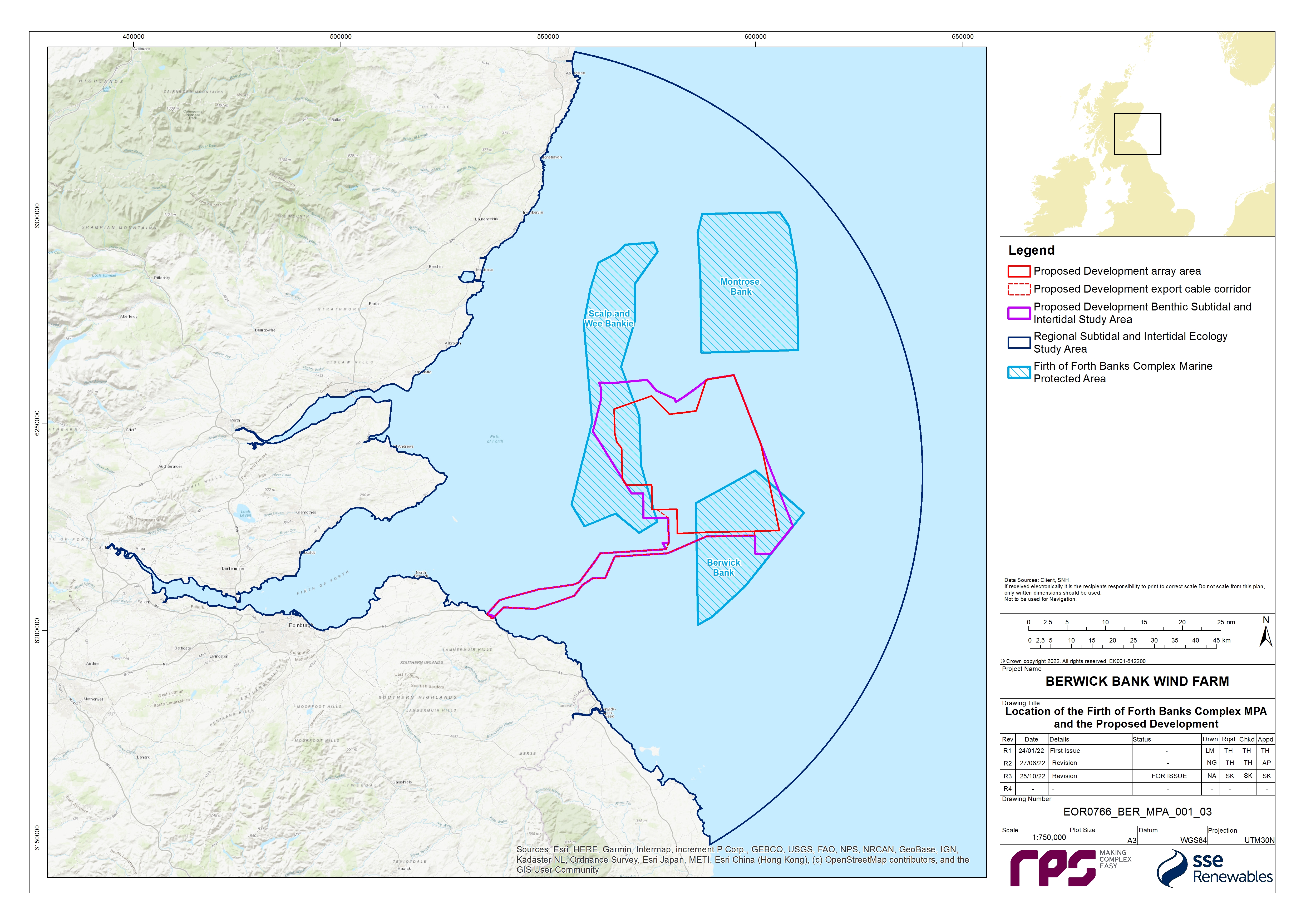
![]()
1.5.2. Screening of Protected Features
- As outlined in paragraph 158 and in the Marine Scotland (2014a) guidelines, following identification of MPAs to be considered, section 126 of the Marine and Coastal Access Act 2009 and section 83 of the Marine (Scotland) Act 2010 would apply if it is determined through the course of screening that “the activity is capable of affecting (other than insignificantly) either (i) any protected feature of a Nature Conservation MPA; or (ii) any ecological or geomorphological process on which the conservation of any protected feature in a Nature Conservation MPA is (wholly or in part) dependent.”
- All of the designated features of the Firth of Forth Banks Complex MPA were identified as having the potential to be affected by the Proposed Development in the Berwick Bank Wind Farm Offshore Scoping Report (SSER, 2021a) and based on the criteria outlined in paragraph 19 have been included due to the MPA’s overlap with the Proposed Development.
- Following the Marine Scotland (2014a) guidelines, any impacts that are concluded in the Offshore EIA Report to have an effect of negligible significance on benthic ecology receptors (including protected features of the MPA) can be screened out and not taken through to the main assessment. Impacts which were concluded to have an effect of negligible significance on protected features of the MPA, within volume 2, chapter 8 of the Offshore EIA Report, are considered to present a sufficiently low risk to these features or the ecological or geomorphological processes on which the conservation of these features are (wholly or in part) dependent, so as to allow these to be screened out at this stage. The following impacts have therefore been screened out and are not considered in the main assessment:
- Temporary habitat disturbance during the operation and maintenance phase for all features except ocean quahog - volume 2, chapter 8 of the Offshore EIA Report predicted an effect of negligible significance on all features of the MPA, with the exception of ocean quahog, due to the short term, temporary nature of the impact, due to the high recovery potential of the habitats and associated communities affected and the highly limited area of seabed predicted to be affected during the operation and maintenance phase;
- Increases in Suspended Sediment Concentration (SSC) and associated sediment deposition during the operation and maintenance phase - volume 2, chapter 8 of the Offshore EIA Report predicted an effect of negligible significance due to the short term, temporary nature of the impact, the high recovery potential of the habitats and associated communities affected and the highly limited area of seabed predicted to be affected during the operation and maintenance phase; and
- Removal of hard substrates resulting in loss of colonising communities during the decommissioning phase - volume 2, chapter 8 of the Offshore EIA Report predicted an effect of minor significance. This impact however would not affect protected features of the MPA because none of the protected features of the MPA would be adversely impacted by the removal of the communities colonising the hard substrates as they all are composed of or rely upon sedimentary habitats. As a result, the effect of this impact is likely to be negligible and therefore it has not been considered further in this MPA Assessment.
- It should be noted that impacts to benthic invertebrates from Electromagnetic Fields (EMFs) were predicted to result in effects of negligible significance in volume 2, chapter 8 of the Offshore EIA Report due to the highly localised nature of the impact and the low sensitivity of the benthic receptors. However, on the basis of advice received from the SNCBs (see Table 1.1 Open ▸ ) this impact pathway has been screened into this MPA Assessment.
- The Marine Scotland (2014a) guidelines also note that many functions and activities can be screened out of the process using generic guidance and evidence on activities which exert pressures on the protected features, which is available through online sensitivity tools. NatureScot’s FeAST online tool has therefore been used to further refine the list of impacts to be included within this MPA Assessment for each of the designated features. On the basis of the FeAST assessments, the following impacts have been screened out where the FeAST tool concludes that the features are not sensitive or not exposed:
- For ocean quahog aggregations, increases in SSC and associated sediment deposition across all phases of the Proposed Development have been screened out on the basis that the FeAST tool concludes that this feature is not sensitive to smothering (siltation changes (low)) and is not exposed to increased SSC (i.e. water clarity changes);
- For the moraines representative of the Wee Bankie key geodiversity area, increases in SSC and associated sediment deposition across all phases of the Proposed Development has been screened out on the basis that the FeAST tool concludes that this feature is not sensitive to increased SSC (i.e. water clarity changes) and smothering (siltation changes (low)) is not relevant to geodiversity features;
- For the moraines representative of the Wee Bankie key geodiversity area, increased risk of introduction and spread of invasive and non-native species (INNS) across all phases of the Proposed Development has been screened out on the basis that the FeAST tool concludes that this pressure is not relevant to geodiversity features;
- For the moraines representative of the Wee Bankie key geodiversity area, colonisation of hard structures has been screened out on the basis that the FeAST tool concludes that this feature is not sensitive to a physical change (to another seabed type);
- For the shelf banks and mounds feature, increased risk of introduction and spread of INNS across all phases of the Proposed Development has been screened out on the basis that the FeAST tool concludes that this pressure is not relevant to geodiversity features; and
- For the shelf banks and mounds feature, colonisation of hard structures has been screened out on the basis that the FeAST tool concludes that this pressure is not relevant to geodiversity features.
1.5.3. Screening Conclusion
- For the Firth of Forth Banks Complex MPA, the following impacts are screened into the main assessment:
- Construction phase:
– temporary habitat disturbance (for all features of the MPA);
– long term subtidal habitat loss (for all features of the MPA); and
- Operation and maintenance phase:
– temporary habitat disturbance (for the following features of the MPA: ocean quahog aggregations);
– long term subtidal habitat loss (for all features of the MPA);
– colonisation of hard structures (for the following features of the MPA: offshore subtidal sands and gravels, ocean quahog aggregations, and shelf banks and mounds);
– increased risk of introduction and spread of INNS (for the following features of the MPA: offshore subtidal sands and gravels and ocean quahog aggregations);
– alteration of seabed habitat arising from effects of physical processes (for all features of the MPA); and
– EMF (for the following features of the MPA: offshore subtidal sands and gravels and ocean quahog aggregations).
- Decommissioning phase:
– temporary habitat disturbance (for all features of the MPA);
– increases in SSC and associated sediment deposition (for the following features of the MPA: offshore subtidal sands and gravels, and shelf banks and mounds);
– permanent subtidal habitat alteration (for all features of the MPA);
– permanent creation of habitat (for the following features of the MPA: offshore subtidal sands and gravels, ocean quahog aggregations, and shelf banks and mounds); and
– increased risk of introduction and spread of INNS (for the following features of the MPA: offshore subtidal sands and gravels and ocean quahog aggregations).
1.6. Background Information on The Firth of Forth Banks Complex MPA
1.6. Background Information on The Firth of Forth Banks Complex MPA
- This section provides a summary of the baseline information for the Firth of Forth Banks Complex MPA considered within the main assessment.
1.6.2. Firth of Forth Banks Complex MPA
- The Firth of Forth Banks Complex MPA, which was designated in July 2014, is located in offshore waters off the east coast of Scotland and covers a total area of 2,130 km2. The MPA is composed of three distinct sections (not connected but in the same area; see Figure 1.11): Berwick Bank (541. 2 km2); Scalp and Wee Bankie (827.1 km2); and Montrose Bank (761.8 km2). Strongly influenced by ocean currents, the mosaic of different types of sands and gravels create a unique mixture of habitats that overlie the underwater banks and mounds within the MPA and support ocean quahog aggregations. The Wee Bankie includes moraines, formed from underwater glacial ridges deposited during the last Ice Age. The moraines are scientifically important for their role in improving the understanding of the history of glaciation around Scotland (JNCC,2018a).
- Volume 3, appendix 8.1 of the Offshore EIA Report provides a detailed description of benthic ecology baseline characterisation within the Proposed Development, including the area overlapping with the Firth of Forth Banks Complex MPA. The baseline was informed by desktop data sources and site-specific surveys (fully detailed in volume 3, appendix 8.1 of the Offshore EIA Report) which were used to characterise the areas of the MPA sections overlapping with the Proposed Development.
- Table 1.33 Open ▸ presents the protected features of the Firth of Forth Banks Complex MPA, with their spatial extents within the MPA (JNCC, 2018b), the condition of the protected feature (JNCC, 2020) and the overarching conservation objectives (JNCC, 2018b). These features, as mapped by the JNCC, are shown relative to the Proposed Development array area and Proposed Development export cable corridor in Figure 1.12. The MPA is characterised by four protected features: ocean quahog aggregations; offshore subtidal sands and gravels; shelf banks and mounds; and moraines (which are representative of the Wee Bankie Key Geodiversity Area).
- Whilst Figure 1.12 represents the offshore subtidal sands and gravels feature as point data only, the JNCC Supplementary Advice on Conservation Objectives for Firth of Forth Banks Complex Nature Conservation MPA (JNCC, 2018b) states that this habitat has been mapped using full coverage bathymetry and backscatter data, as well as benthic video and image sample data, which demonstrated that >99% of the MPA is modelled as offshore subtidal sands and gravels. Offshore subtidal sands and gravels and supporting habitat for ocean quahog aggregations are therefore assumed to extend across the whole of the MPA. The shelf banks and mounds protected feature characterises sizable areas within each of the sections of the MPA and overall covers ~264 km2 within the MPA. The moraines representative of the Wee Bankie key geodiversity area feature occur most extensively in the Scalp and Wee Bankie section of the MPA but are also mapped within Berwick Bank and a small area within Montrose Bank (Figure 1.12); overall this feature covers ~750 km2 of the MPA. Beyond the protected features, the MPA is dominated by Atlantic and Mediterranean moderate energy infralittoral rock and deep circalittoral coarse sediment, with smaller areas of deep circalittoral mixed sediment and deep circalittoral mud.
Table 1.33: Protected Features of the Firth of Forth Banks Complex MPA, Recorded Extents (see Figure 1.12), Condition and Conservation Objectives
- For the Firth of Forth Banks Complex MPA, the conservation objectives for the site are that the protected features:
- so far as already in favourable condition, remain in such condition; and
- so far as not already in favourable condition, be brought into such condition, and remain in such condition.
- extent is stable or increasing;
- structures and functions, quality, and the composition of characteristic biological communities (which includes a reference to the diversity and abundance of species forming part of or living within the habitat) are such as to ensure that they remain in a condition which is healthy and not deteriorating.
- the extent, distribution and structure is maintained;
- the function is maintained to ensure that it continues to support its characteristic biological community (which includes a reference to the diversity of any species associated with the large- scale feature), and their use of the site for, but not restricted to, feeding, courtship, spawning, or use as nursery grounds; and
- the processes necessary to support the feature are maintained.
- For the ocean quahog aggregations protected feature, "favourable condition" is when:
- the quality and quantity of its habitat and the composition of its population in terms of number, age and sex ratio are such as to ensure that the population is maintained in numbers which enable it to thrive.
- For the moraines representative of the Wee Bankie key geodiversity area within the Firth of Forth Banks Complex MPA, "favourable condition" is when:
- its extent, component elements and integrity are maintained;
- its structure and function are unimpaired; and
- its surface remains sufficiently unobscured for the purposes of determining whether the above criteria are satisfied.
- As set out in Table 1.33 Open ▸ , the offshore subtidal sands and gravels and ocean quahog aggregations features need to be recovered to favourable condition (JNCC, 2020). The Supplementary Advice on Conservation Objectives document (JNCC, 2018b) advise that, for the offshore subtidal sands and gravels, this relates to the structure and function attribute and, specifically, the characteristic communities and consequently function. While the feature is naturally exposed to moderate energy levels (due to the tidal currents present in the site), the level of fishing activity present in the site suggests the structure and function of the feature has been impacted as a result of this activity. JNCC consider that the activities which are capable of significantly affecting the protected features of the site and should be managed to prevent further deterioration to offshore subtidal sands and gravels and ocean quahog aggregations are demersal trawling and renewable energy (JNCC, 2020).
- Volume 3, appendix 8.1 of the Offshore EIA Report provides a detailed description of the baseline environment within the Firth of Forth Banks Complex MPA which was informed by desktop data sources and site-specific surveys undertaken for the Proposed Development. It should be noted that the spatial extent of the site-specific benthic subtidal surveys included some areas which, due to refinements to the boundary of the Proposed Development, extend beyond the boundary of Proposed Development benthic subtidal and intertidal ecology study area shown in Figure 1.13. This resulted in some sampling of areas to the north-west, south-west and south-east of the Proposed Development array area, and also inshore areas to the south of the Proposed Development export cable corridor. The data collected from these areas were analysed and included in the baseline characterisation as they provide further context to the data collected within the Proposed Development benthic subtidal and intertidal ecology study area. Samples were collected within the area of the Firth of Forth Banks Complex MPA which overlaps with the benthic subtidal and intertidal ecology study area (Figure 1.11). Within the Berwick Bank section of the MPA, 13 stations were sampled via a combination of grab and drop-down video (DDV), three sites used only DDV sampling and two epibenthic trawls were conducted. Within the Scalp and Wee Bankie section of the MPA, 13 stations were sampled via grab and DDV, one sites used only DDV sampling and two epibenthic trawls were conducted. A geophysical survey campaign was also undergone to characterise the Proposed Development benthic subtidal and intertidal ecology study area including the areas which overlap with the Firth of Forth Banks Complex MPA.
- Figure 1.13 shows the results of the geophysical surveys which indicated that both the Berwick Bank and Scalp and Wee Bankie sections of the MPA, which overlap with the Proposed Development, are characterised by featureless areas as well as sections of ripples and mega ripples, sand waves, ribbons, and bars. The geophysical data also showed areas of trawl marks within both sections of the MPA as well as areas of deposition and erosion. Figure 1.13 also shows the results of the particle size analysis (PSA) which indicated that the sediments within the Berwick Bank part of the MPA which overlaps with the Proposed Development are characterised based on the Folk classification system (Folk, 1954; Long, 2006) described in volume 3, appendix 8.1 of the Offshore EIA Report) as slightly gravelly sand and gravelly sand. The sediments within the Scalp and Wee Bankie part of the MPA which overlap with the Proposed Development are characterised by slightly gravelly sands and sandy gravels with two samples of gravelly sand, one in the north and one in the south. The site-specific data is therefore consistent with the modelled distribution of the offshore subtidal sands and gravels feature within the MPA (i.e. extending across the whole MPA) as presented in the Supplementary Advice on Conservation Objectives document (JNCC, 2018b). This would also, therefore, indicate that the sediments present within the Proposed Development array area represent suitable supporting habitat for ocean quahog. The parts of the Firth of Forth Banks Complex MPA which are outside the Proposed Development array area and Proposed Development export cable corridor were not surveyed as part of the site-specific surveys undertaken for the Proposed Development.
- Figure 1.14 shows the subtidal biotopes mapped within and around the Firth of Forth Banks Complex MPA from the Proposed Development site-specific survey data detailed in paragraph 171. The process by which these biotopes were assigned is fully described in volume 3, appendix 8.1 of the Offshore EIA Report. The part of the Proposed Development which coincides with the Berwick Bank section of the MPA was primarily characterised by the Amphiura filiformis, Mysella bidentata and Abra nitida in circalittoral sandy mud biotope (SS.SMu.CSaMu.AfilMysAnit) with smaller areas of offshore circalittoral sand (SS.SSa.OSa), offshore circalittoral sand with Echinocyamus pusillus (SS.SSa.OSa [Echinocyamus pusillus]), and the Echinocyamus pusillus, Ophelia borealis and Abra prismatica in circalittoral fine sand biotope (SS.SSa.CFiSa.EpusOborApri). The section of the Proposed Development which coincides with the Scalp and Wee Bankie section of the MPA was primarily characterised by the polychaete-rich deep Venus community in offshore mixed sediments biotope (SS.SMx.OMx.PoVen) and the SS.SMu.CSaMu.AfilMysAnit biotope. Smaller areas of the SS.SSa.CFiSa.ApriBatPo biotope, the seapens and burrowing megafauna in circalittoral fine mud biotope (SS.SMu.CFiMu.SpnMeg), the SS.SSa.CFiSa.EpusOborApri biotope, and SS.SSa.OSa were also present. The site-specific data is therefore consistent with the evidence from the MPA designation documents (JNCC, 2014) and the Supplementary Advice on Conservation Objectives document (JNCC, 2018b) which states that the offshore subtidal sands and gravels feature equates to the EUNIS habitats A5.1: Subtidal coarse sediments, A5.2: Subtidal sand, and A5.4: Subtidal mixed sediments.
- Additionally, as previously mentioned within Scalp and Wee Bankie, the site-specific grabs, trawls and DDV sampling recorded two ocean quahogs in the area which overlaps with the Proposed Development array area. The ocean quahog recorded within the MPA during the grab sampling was in the western central section of the Proposed Development array area and was 0.2 cm in size and estimated to be less than a year old. The ocean quahog recorded during the epibenthic trawls was in the north-east of the Proposed Development array area, was 11 cm in size and estimated to be 193 years old (volume 3, appendix 8.1 of the Offshore EIA Report). Again, this is consistent with the sediments within the Proposed Development array area representing suitable supporting habitat for ocean quahog.
- Annex I reef assessments, for both biogenic (e.g. Sabellaria spinulosa) and geogenic reefs, were also conducted within the Proposed Development benthic subtidal and intertidal ecology study area using DDV and in accordance with the latest guidance, however no sites within the Firth of Forth Banks Complex MPA were found to contain Annex I reefs. The nearest potential reef site lay over a kilometre away, north of Berwick Bank at sample site 38 which was found to be a low reefiness (Jenkins et al., 2015; Gubbay, 2007) rocky reef.
- Additionally M. modiolus were recorded in several of the benthic trawls and therefore the full extent of the benthic trawls are presented in Figure 1.14 as the exact location of the M. modiolus is unknown. M. modiolus was recorded within a single trawl in the Berwick Bank section of the Firth of Forth Banks Complex MPA (Figure 1.14).


1.7. Main Assessment – Firth of Forth Banks Complex MPA
1.7. Main Assessment – Firth of Forth Banks Complex MPA
1.7.1. Project Alone Assessment
- This section presents the main assessment of the effects of the construction, operation and maintenance and decommissioning of the Proposed Development on the protected features of the Firth of Forth Banks Complex MPA. Each of the impacts identified in the initial screening stage (see section 1.4.3) are discussed individually in the following sections and within each assessment, the effects on attributes and targets of the relevant protected features, and subsequently on the conservation objectives, are considered, using the best available scientific evidence to support the conclusions made.
- Table 1.34 Open ▸ presents a summary matrix of the individual feature attributes of the Firth of Forth Banks Complex MPA considered within each assessment. For the purposes of this assessment, attributes were broadly categorised as either physical or ecological attributes. Table 1.34 Open ▸ provides signposting to the relevant paragraph references of the main assessment below, which provides the justification for the conclusions made with respect to the attributes of the protected features of the Firth of Forth Banks Complex MPA. The colour coding represents the conclusions made within the main assessment of this report. Colour coding is as follows:
- Blue: No significant effect on attribute or target(s);
- Red: Significant effect on attribute or target(s); and
- Grey: No attribute - impact pathway (not applicable).
Table 1.34: Attribute Versus Impact Signposting and Summary Matrix for Stage 1 Assessment of the Proposed Development on the Firth of Forth Banks Complex MPA (Colour Coding Relates to Conclusions with Respect to Impacts Attributes: Blue – No Significant Effect on Attribute or Target(s); and Grey - No Attribute – Impact Pathway)
* Assessment for long term habitat loss/alteration has been combined for the construction and operation and maintenance phases.
Overarching assessment assumptions
- The extent of overlap between the Proposed Development and the Firth of Forth Banks Complex MPA is 331.7 km2, which equates to 15.57% of the total area of the MPA (see Table 1.35 Open ▸ ). This comprises 15.2 km2 within the Proposed Development export cable corridor (0.71% of the MPA area) and 316.5 km2 within the Proposed Development array area (14.86% of the MPA area). This can be further divided between the two sections of the Firth of Forth Banks Complex MPA which overlap with the Proposed Development as follows and summarised in Table 1.35 Open ▸ :
- 229.5 km2 of the Proposed Development overlapping with the Berwick Bank part of the MPA – this equates to 42.42% of the area of the Berwick Bank part of the MPA and represents 69.19% of the Proposed Development overlap with the MPA; and
- 102.2 km2 of the Proposed Development overlaps with Scalp and Wee Bankie – this equates to 12.36% of the area of Scalp and Wee Bankie and represents 30.81% of the Proposed Development overlap with the MPA.
Table 1.35: Summary of the Extent of the Overlap Between the Proposed Development and the Firth of Forth Banks Complex MPA (as a Whole, and for the Component Sites)
Infrastructure within the Firth of Forth Banks Complex MPA
- A total of 331.7 km2 of the Proposed Development array area overlaps with the Firth of Forth Banks Complex MPA, which equates to 31.33% of the total Proposed Development array area. It is assumed that 31.33% of the array area infrastructure could be installed within the MPA (e.g. the maximum design scenario for long term habitat loss under foundations assumes that 56 of the total 179 foundations for a larger wind turbine scenario could be installed within the Firth of Forth Banks Complex MPA); and
- 13.08% of the Proposed Development export cable corridor overlaps with the Firth of Forth Banks Complex MPA and therefore it is assumed that 13.08% of offshore export cables could be installed within the MPA.
Offshore subtidal sands and gravels and ocean quahog aggregations
- As outlined in paragraph 173, approximately 100% of the total area of the Firth of Forth Banks Complex MPA is modelled as the offshore subtidal sands and gravels feature, and therefore also represents the extent of supporting habitat for ocean quahog aggregations. For the purposes of this assessment, it is therefore assumed that all the infrastructure which could be placed within the Firth of Forth Banks Complex MPA, as outlined in paragraph 189, could be placed within these features.
Shelf banks and mounds
- As outlined in paragraph 173, unlike the offshore subtidal sands and gravels feature, the shelf banks and mounds protected feature does not cover the full extent of the MPA; the shelf banks and mounds feature covers approximately 19.48% of the area of the MPA which overlaps with the Proposed Development, Figure 1.12. Therefore, to adopt the same assumptions outlined in paragraph 189 for offshore subtidal sands and gravels would be unrealistic and would overestimate the maximum design scenario for the shelf banks and mounds feature. For the purposes of this assessment it is therefore assumed that 19.48% of the infrastructure which could be placed within the Firth of Forth Banks Complex MPA could be placed within this feature (e.g. the maximum design scenario for long term habitat loss under foundations assumes that 11 of the 56 foundations for the larger wind turbine scenario which could be installed within the Firth of Forth Banks Complex MPA could be installed within the shelf banks and mounds feature).
Wee Bankie key geodiversity area (moraines)
- As outlined in paragraph 173, unlike the offshore subtidal sands and gravels feature, the Wee Bankie Key Geodiversity Area (Moraines) protected feature does not cover the full extent of the MPA; the moraines feature covers approximately 22.17% of the area of the MPA which overlaps with the Proposed Development, Figure 1.12). Therefore, to adopt the same assumptions outlined in paragraph 189 for offshore subtidal sands and gravels would be unrealistic and would overestimate the maximum design scenario for the Wee Bankie Key Geodiversity Area (moraines) feature. For the purposes of this assessment, it is therefore assumed that 22.17% of the infrastructure which could be placed within the Firth of Forth Banks Complex MPA could be placed within this feature (e.g. the maximum design scenario for long term habitat loss under foundations assumes that 12of the 56 foundations for the larger wind turbine scenario which could be installed within the Firth of Forth Banks Complex MPA could be installed within the moraines feature).
- Measures Adopted as Part of the Proposed Development As part of the Project design process, a number of measures have been proposed to reduce the potential for impacts on benthic subtidal and intertidal ecology and features of the MPA (see Table 1.36 Open ▸ ). As there is a commitment to implementing these measures, they are considered inherently part of the design of the Proposed Development) and have therefore been considered in the main assessment. These measures are considered standard industry practice for this type of development.
Table 1.36: Designed In Measures Adopted as Part of the Proposed Development
Main assessment
Temporary Habitat Disturbance
Construction phase
- Direct temporary disturbance of subtidal habitat may occur within the Firth of Forth Banks Complex MPA during the construction phase as a result of the installation of inter-array cables, interconnector cables, offshore export cables and wind turbine foundation installation activities (including site preparation works such as sand wave and boulder clearance, anchor placements and vessel jack-ups).
- For the purposes of this assessment, temporary habitat disturbance refers to the impact of activities and events which will produce effects which are temporary within the environment. After the cessation of the activities associated with this impact a shift toward the original baseline of the environment will occur via the recovery of the sediments themselves and the associated communities. Temporary impacts to sediments and benthic communities has been considered separately from long term habitat loss (see paragraph 291 et seq.) which considers the footprint of seabed which will be occupied by the Proposed Developments infrastructure (e.g. wind turbines and scour protection) over its 35 year lifetime. Finally, where there is the potential for cable and scour protection to remain on the seabed following the decommissioning process and to remain in perpetuity, this is referred to, and has been assessed, as permanent habitat alteration (see paragraph 0 et seq.) on the basis that this habitat will be recolonised over time.
- This assessment is equivalent to the following pressures identified by JNCC's Advice on Operations for the Firth of Forth Banks Complex MPA for ‘Renewable Energy: offshore wind’ and ‘Power cables: laying burial and protection’ (JNCC,2018c):
- Abrasion/disturbance of the substrate on the surface of the seabed;
- Penetration and/or disturbance of the substratum below the surface of the seabed, including abrasion;
- Habitat structure changes - removal of substratum (extraction); and
- Siltation rate changes (high), including smothering (depth of vertical sediment overburden).
- Table 1.37 Open ▸ presents the maximum design scenario for temporary habitat disturbance within the Firth of Forth Banks Complex MPA during the construction phase.
- On the basis of the assumptions outlined in paragraph 189, there may be up to 24.70 km2 of temporary habitat disturbance within the Firth of Forth Banks Complex MPA during the construction phase, equating to 1.16% of the total area of the MPA. Of this total, up to 7.61 km2 may occur within the Scalp and Wee Bankie section of the MPA[9] (0.36% of the total area of the MPA or 1.92% of the area of the Scalp and Wee Bankie section of the MPA) and up to 17.09 km2 within the Berwick Bank part of the MPA[10] (0.8% of the total area of the MPA or 3.16% of the area of the Berwick Bank section of the MPA). This assessment considers the effects of construction activities resulting in temporary habitat disturbance on the attributes and targets for the offshore subtidal sand and gravels, shelf banks and mounds, ocean quahog aggregations and moraines representative of the Wee Bankie key geodiversity area features and therefore the assessment has been subdivided according to these feature types.
Table 1.37: Maximum Design Scenario for Temporary Habitat Disturbance within the Firth of Forth Banks Complex MPA During the Construction Phase
1 For the purposes of replicating the calculations in this table, 31.33% is calculated as 316.5 km2/1010.2 km2 (i.e. overlap between Proposed Development array area / total Proposed Development array area).
2 For the purposes of replicating the calculations in this table, 13.08% is calculated as 114.08 km/872 km (i.e. proportion of total length of export cables that could occur within the part of the Proposed Development export cable corridor that overlaps with the MPA).
Offshore subtidal sands and gravels
- On the basis of the assumptions outlined in paragraph 190, all of the temporary habitat disturbance predicted within the MPA (i.e. 24.70 km2) could occur entirely within the offshore subtidal sands and gravels feature of the MPA. This would equate to temporary habitat disturbance of up to 1.16% of the offshore subtidal sands and gravels feature within the MPA (see Table 1.38 Open ▸ ). Of this temporary habitat disturbance up to 7.6 km2 could occur within the Scalp and Wee Bankie part of the MPA9 (0.92% of the offshore subtidal sands and gravels feature within the MPA) and up to 17.09 km2 could occur in the Berwick Bank part of the MPA10 (0.8% of the feature within the whole MPA) (see Table 1.38 Open ▸ ).
Table 1.38: Summary of the Extent of Temporary Habitat Disturbance within the Firth of Forth Banks Complex MPA (as a Whole, and for the Component Sites) during the Construction Phase
1 Calculated as 30.81% of the 24.7 km2 total on the basis of the overlap with the Scalp and Wee Bankie (see paragraph 170).
2 Calculated as 69.19% of the 24.7 km2 total on the basis of the overlap with the Berwick Bank (see paragraph 188).
3 Calculated as 43.82% of total 7.61 km2 of disturbance within the Scalp and Wee Bankie section (i.e. 43.82% of the total area of Scalp and Wee Bankie that overlaps with the Proposed Development and contains the shelf banks and mounds feature).
4 Calculated as 8.64% of total 17.09 km2 of disturbance within the Berwick Bank section (i.e. 8.64% of the total area of Berwick Bank that overlaps with the Proposed Development and contains the shelf banks and mounds feature).
5 Calculated as 71.59% of total 7.61 km2 of disturbance within the Scalp and Wee Bankie section (i.e.71.59% of the total area of Scalp and Wee Bankie that overlaps with the Proposed Development and contains the moraines feature).
6 Calculated as 0.16% of total 17.09 km2 of disturbance within the Berwick Bank section (i.e. 0.16% of the total area of Berwick Bank that overlaps with the Proposed Development and contains the moraines feature).
- Activities resulting in temporary habitat disturbance will occur intermittently throughout construction period of up to 96-months, with only a proportion of the total maximum area of temporary habitat disturbance occurring at any one time. Following these activities, the sediments would be expected to recover to their baseline state through wave and tidal action, allowing the associated communities to recover into these areas. A recent study reviewed the effects of cable installation on subtidal sediments and habitats, drawing on monitoring reports from over 20 UK offshore wind farms (RPS, 2019). This review showed that sandy sediments recover quickly following cable installation, with trenches infilling quickly following cable installation and little or no evidence of disturbance in the years following cable installation. It also presented evidence that remnant cable trenches in coarse and mixed sediments were conspicuous for several years after installation. However, these shallow depressions were of limited depth (i.e. tens of centimetres) relative to the surrounding seabed, over a horizontal distance of several metres and therefore did not represent a large shift from the baseline environment (RPS, 2019). It has been reported that benthic communities associated with soft sediments (e.g. muds, sands and gravels) readily recover into areas if the sediment type is reflective of the baseline environment (RPS, 2019). Similarly, a study of bedform migration undertaken using historic geophysical surveys within Seagreen 1 (HR Wallingford 2012) also indicated that seabed sediments are mobile and prone to accretion although the underlying bedforms were stable. Thus, from the limited amount of available data it would suggest that any sand-based habitat and sand waves are likely to recover over several years. Evidence for other industries and regions suggests that sand based sediments can recover over shorter periods. For example, Newell et al. (2004) reports recovery times of months to one or two years.
- The effects of temporary habitat disturbance during the construction phase will be temporary and cease following completion of the construction activities. Whilst flora and fauna will be affected, recoverability in most cases is likely to be medium, as a result of passive import or larvae and active migration of juveniles and adults from adjacent non-affected areas. Evidence from the marine aggregates industry suggests that recovery on sandy sediments will happen over a relatively short time scale (e.g. months to one or two years; Newell et al., 2004), and coarse, gravelly and mixed sediments showing longer recovery timescales, usually within five years (Desprez, 2000; Newell et al., 1998), but in some cases, recovery has been reported as taking up to nine years following cessation of dredging (Foden et al., 2009).
- Based on the information presented above, the following can be concluded with respect to the physical attributes of the protected features of the Firth of Forth Banks Complex MPA:
- Extent and distribution of the offshore subtidal sands and gravels feature will be maintained in the long term following the completion of the construction phase, with only a small proportion of the total extent of this feature within the MPA affected (1.16%). These effects are limited to the northern half of the Berwick Bank section of the MPA (affecting up to 17.09 km2 which equates to 0.80% of the total extent of this feature within the MPA) and the southern/central section of Scalp and Wee Bankie (affecting up to 7.61 km2 which equates to 0.36% of the total extent of the feature within the MPA). In addition, any effects on the offshore subtidal sands and gravels feature will be temporary and reversible with recovery of sediments occurring following the completion of construction. Recovery of the sand waves within this feature will be monitored at a representative number of locations where sand wave clearance activity has taken place as part of wider Project pre- and post-construction geophysical surveys (monitoring commitments are detailed in Table 1.59 Open ▸ ). This is consistent with the ‘conserve’ objective of the extent and distribution attribute for this feature.
- The activities associated with the cable installation, jack-up events and anchor placements are not expected to impact upon the hydrodynamic regime of the area as no permanent structures are needed to complete these works. The fine scale features of this site include relict banks and mounds which are part of the Wee Bankie Key Geodiversity Area feature and do not rely on hydrodynamics as they were formed during the last glacial period. Sand ripples are also found in the MPA which are formed by the prevailing hydrodynamic regime from the dominant sediment type. There is likely to be little to no effect on fine scale topographic features as the associated processes which they rely on will be maintained throughout this phase. This is consistent with the ‘recover’ objective of the structure and function attribute for this feature.
- The sediment composition of the offshore subtidal sands and gravels protected feature is unlikely to be affected by the temporary habitat disturbance impact. Whilst sand wave clearance will temporarily remove sediment, it will be deposited locally, and the high rate of sedimentation will ensure rapid redistribution of material (sand wave recovery will be monitored as part of designed in monitoring commitments, see Table 1.59 Open ▸ ). Boulder clearance activities may result in a redistribution of boulders and cobbles within discrete areas and could potentially concentrate these in the areas either side of the cleared corridor. Since no sediment/substrate is being removed and given the existing patchiness of the distribution of cobbles and boulders in the offshore environment, this is considered unlikely to represent a significant shift in the baseline situation. Additionally, the limited change to the hydrodynamic regime is unlikely to lead to any change in the prevailing sediment composition. This is consistent with the ‘recover’ objective of the structure and function attribute for this feature.
- The hydrodynamic regime of the offshore subtidal sands and gravels protected feature is one of the supporting processes which regulates many key processes through the speed and direction of currents and wave exposure. The temporary and relatively localised scale of the habitat disturbance in the construction phase are unlikely to result in significant changes to tidal currents and wave exposure, maintaining the regime and its associated processes throughout the Firth of Forth Banks Complex MPA. This is consistent with the ‘conserve’ objective of the supporting processes attribute for this feature.
- The activities resulting from the construction phase of the Proposed Development are not expected to result in any contamination related impacts due to the implementation of a marine pollution contingency plan (see volume 4, appendix 22, annex A of the Offshore EIA Report) (see
Table 1.36
Open ▸
). Water quality will also be maintained due to the temporary and localised nature of disturbance resulting in unlikely change to the tidal currents of the Firth of Forth Banks Complex MPA. The results of the Water Framework Directive assessment (volume 3, appendix 18 of the Offshore EIA Report) found that the impacts on water quality are predicted to result in effects of negligible to minor adverse significance for all likely significant effects due to their high reversibility. Sediment contamination sampling was undertaken as part of the site-specific benthic surveys (see volume 3, appendix 8.1 of the Offshore EIA Report) which showed that none of the metal contaminants assessed exceeded Action Level One (determined by the Centre for Environment Fisheries and Aquaculture Science (Cefas), material below Action Level One is thought to not be of concern in terms of the contaminant concentrations). As a result, of this assessment and the implementation of contingency plans, water and sediment quality/contamination were scoped out of the Offshore EIA Report and therefore will not be assessed further in this MPA Assessment.
- Offshore subtidal sands and gravels biotopes were identified in the site-specific benthic surveys (Figure 1.14), and included Abra prismatica, Bathyporeia elegans and polychaetes in circalittoral fine sand (SS.SSa.CFiSa.ApriBatPo) and Echinocyamus pusillus, Ophelia borealis and Abra prismatica in circalittoral fine sand (SS.SSa.CFiSa.EpusOborApri). Both of these biotopes have a low sensitivity to penetration and surface abrasion and medium sensitivity to removal of substratum. This soft sediment environment has been characterised by burrowing polychaetes and burrowing bivalves with some epifauna which are unlikely to experience anything other than localised decline in species richness. The majority of infauna will be expected to burrow back into the sediment following displacement with only a small degree of mortality resulting from predation, larger fragile species are more likely to be damaged and therefore unable to borrow back into the sediment (Tillin et al., 2006).
- The habitat features predicted to be directly affected by temporary habitat disturbance typically have low to medium sensitivity to disturbance of this nature. The communities associated with the offshore subtidal sands and gravel sediment are typical of high energy environments and are therefore naturally subject to and tolerant of physical disturbance (Tillin, 2016a; Tillin, 2016b). The species which characterise these biotopes are predominantly infaunal burrowing species such as polychaetes and bivalves, which are capable of re-entering the substratum following disturbance (Gilkinson et al., 1998; Hauton et al., 2003). The recovery is likely to occur as a result of a combination of recruitment from adjacent habitats and larval dispersal. Recovery is likely to occur within a minimum of one year after cable installation (RPS, 2019).
- Based on the information presented above, the following can be concluded with respect to the ecological attributes of the offshore subtidal sands and gravels feature of the Firth of Forth Banks Complex MPA:
- With respect to the key influential species that have a key role in determining the structure and function of the offshore subtidal sands and gravels feature, it is considered that they will be minimally affected, with only a small proportion (1.16%) of the total extent of this feature within the MPA affected. Where temporary habitat disturbance occurs, this will lead to localised reductions in species richness especially where sediment is, temporarily, physically removed (e.g. sand wave clearance prior to deposition). A full recovery of these communities into these affected areas would be expected within a few years following disturbance, which will be enabled by the burrowing capacity of many of the key species allowing them to escape heavy siltation. Whilst the temporary removal of sediment will occur during sand wave clearance, the material will be deposited local to the area and repopulation is likely to occur within a matter of years due to passive import or larvae and active migration of juveniles and adults from adjacent non-affected areas. These processes ensure that the key and influential species of the offshore subtidal sands and gravels protected features will be maintained across the Firth of Forth Banks Complex MPA. This is consistent with the ‘recover’ objective of the structure and function attribute for this feature.
- The presence and spatial distribution of the characteristic communities will be maintained across the Firth of Forth Banks Complex MPA. Only a small proportion of the offshore subtidal sands and gravels feature will be affected in the Berwick Bank section of the MPA (disturbing 3.16% of the total area of the Berwick Bank section of the MPA) and a southern/central section of Scalp and Wee Bankie (disturbing 0.92% of the total extent of Scalp and Wee Bankie). Effects on biological communities leading to a reduction in species richness) are only predicted to occur in discrete areas (e.g. in the footprint of direct contact with the cable installation tool for example), with habitat disturbance only affecting a relatively small area at any one time enabling the maintenance of the diverse composition of communities in this feature. The physical environment of this feature is characterised by its high energy currents which support and form the characteristic community of this feature, this suggests that the communities present may be relatively robust and able to tolerate some level of abrasion pressure such as from dredge fishing (which already takes place in the area (JNCC, 2018b; volume 3, appendix 12.1 of the Offshore EIA Report)) or from the construction phase of the Proposed Development. Additionally, the physical conditions of the Firth of Forth Banks Complex MPA are unlikely to be affected significantly in the long term due to the construction activities, therefore maintaining the physical environmental conditions which underpin these communities. The recovery of these communities following the completion of construction is likely due to their tolerance of these activities. Following construction activities, a full recovery of these communities is predicted to occur as the sediment re-establishes (RPS, 2018). This is consistent with the ‘recover’ objective of the structure and function attribute for this feature.
- The function of the offshore subtidal sands and gravel feature, which is defined by its biological productivity, nutrition provision and climate regulation, will be maintained throughout the construction period of the Proposed Development. The highly localised and temporary nature of the disturbance of the sedimentary environment will ensure that the stability of the majority of the sediment is maintained enabling it to maintain its function as a carbon sink, productive habitat, and spawning ground for fish species such as sandeels. Whilst temporary disturbance to spawning habitat of fish species, such as herring, sandeels and elasmobranchs, can cause mortality to some eggs should activities occur during the spawning period, this represents a small area compared to the abundance of similar substrate types within the Proposed Development and the Firth of Forth Banks Complex MPA. A recent monitoring study conducted at Beatrice Offshore Wind Farm found levels of sandeels were the same or increased three years after construction was completed, which suggests that the effects of construction activities on sandeel spawning are not detrimental in the long term (Beatrice Offshore Wind Farm Ltd., 2021). Herring favour gravel and sandy gravel substrate for their spawning grounds, whereas the MPA is dominated by sands which are unsuitable for herring therefore limiting the impact of disturbance. Overall, it can be concluded that the impacts on fish and shellfish spawning habitat is limited spatially and temporally and aided by the recoverability of the species involved. Furthermore, the limited nature of the construction interference with the wave and tidal regime also contributes to this stability as well as enabling the internal hydrodynamic features to prevail and support the biological community, allowing the offshore subtidal sands and gravels protected feature to fulfil all of its functions. This is consistent with the ‘recover’ objective of the structure and function attribute for this feature.
- Volume 2, chapter 8 of the Offshore EIA Report concluded that due to the temporary, reversible, and intermittent nature of the impact of temporary habitat disturbance during construction, and the relatively small proportion (1.32%) of the protected features to be affected during construction, the magnitude of the impact on the features of the Firth of Forth Banks Complex MPA was low. The offshore subtidal sands and gravels protected feature of the Firth of Forth Banks Complex MPA is considered to be of medium vulnerability, medium recoverability and national importance and therefore was considered to have a medium sensitivity. Therefore, the significance of effect was considered to be minor adverse, which is not significant in EIA terms, as the sediments and communities are predicted to recover.
- Based on the information presented here, it can be concluded that temporary habitat disturbance during the Proposed Development construction phase will not lead to a significant risk of hindering the achievement of the overall conservation objectives (i.e. “recover to favourable condition”) for this feature of the Firth of Forth Banks Complex MPA for the following reasons:
- While the temporary habitat disturbance is predicted to affect a small proportion of the offshore subtidal sands and gravels feature (1.16%) intermittently during the construction phase, these habitats will recover such that the extent and distribution of the protected feature will remain stable following the construction phase; and
- The structures and functions, quality, and the composition of characteristic communities will remain in (or recover to) a condition which is healthy and not deteriorating. Recovery of the seabed sediment will occur in the months following seabed preparation and cable installation, with complete recovery within the areas affected within a few years. The key and influential species are predicted to recolonise disturbed sediment, with full recovery of characteristic communities within months to years of construction; as supported by analogous studies from the aggregates, and offshore wind industry. These communities will be supported by an undisturbed hydrodynamic regime which will continue to form the fine scale features of the MPA.
Shelf banks and mounds
- On the basis of the assumptions outlined in paragraph 191, and for the purposes of this assessment it is assumed that 19.48% of the maximum temporary habitat disturbance from the construction of the Proposed Development within the MPA could occur in this feature, equating to 4.81 km2 or 1.82% of the shelf banks and mound feature within the MPA. Of this temporary habitat disturbance, up to 3.33 km2 could occur within Scalp and Wee Bankie (1.26% of the feature within the whole MPA) and 1.48 km2 could occur in the Berwick Bank part of the MPA (0.56% of the feature within the whole MPA) (see Table 1.38 Open ▸ ).
- Activities resulting in temporary habitat disturbance will occur intermittently throughout construction period of up to up to 96 months, with only a proportion of the total maximum area of temporary habitat disturbance occurring at any one time. Following these activities, sediments would be expected to recover to their baseline state through wave and tidal action (volume 2, chapter 7 of the Offshore EIA Report), allowing the associated communities to recover into these areas. Further detail is provided in paragraph 200. As outlined in Table 1.59 Open ▸ , the Applicant is committed to the monitoring of the recovery of sand waves within the MPA via pre- and post-construction geophysical surveys to validate the predictions of this assessment.
- Effects of temporary habitat disturbance during the construction phase will be temporary and cease following completion of the construction activities. Whilst flora and fauna will be affected, recoverability in most cases is likely to be medium, as a result of passive import or larvae and active migration of juveniles and adults from adjacent non-affected areas. These predictions are similar to those made for offshore subtidal sands and gravels as they are characterised by the same biotopes.
- Based on the information presented above, the following can be concluded with respect to the physical attributes of the protected features of the Firth of Forth Banks Complex MPA:
- The extent and distribution of this protected feature within the MPA is determined by the prevailing hydrodynamic regime. The activities involved in the construction of the Proposed Development will result in minimal change to sediment transport processes and prevailing hydrodynamic regime which forms this feature. Where processes are disrupted by the removal and deposition of sediment for seabed preparation or cable installation the effects will be temporary, and sediment will be deposited locally to be re-distributed and reformed by the hydrodynamic regime. As there is no permanent removal of sediment or permanent changes to the environment during the construction phase, the hydrodynamic regime will not be impacted. Overall, this protected feature will be conserved throughout the construction phase and following the conclusion of construction the protected feature will quickly recover from the effects of this temporary impact. This is consistent with the ‘conserve’ objective of the extent and distribution attribute for this feature.
- The strong currents in the MPA have resulted in the formation of the banks which can rise ~30 m to 50 m above the surrounding seabed and are composed of a mosaic of sediment types caused by the banks and mounds interacting with the tidal currents. As discussed above, the hydrodynamic regime will not be impacted through temporary habitat disturbance. Due to the large scale of the features, it is unlikely that the activities which will remove, and then deposit, sediment will have an impact. Sand wave clearance for example will typically remove sand waves with an average height of 1.3 m and the maximum burial depth for all cables is 3 m, both of which are much smaller than the height of this feature. The physical nature of the shelf banks and mounds feature is therefore not expected to be affected due to the temporary nature of the activities and the large scale of the protected feature. This is consistent with the ‘conserve’ objective of the structure and function attribute for this feature.
- The previous two points clarify that the hydrodynamic regime and sediment transport systems which support this protected feature will be minimally impacted by temporary habitat disturbance during the construction phase, therefore maintaining the supporting processes of this protected feature. This is consistent with the ‘conserve’ objective of the supporting processes attribute for this feature.
- The ecological attributes which characterise the shelf banks and mounds protected feature were assessed for the pressures involved in the temporary habitat disturbance impact in volume 2, chapter 8 of the Offshore EIA Report. This assessment found that this characteristic species for this feature are the same as those for offshore subtidal sands and gravels, the sensitivity of this biotopes is discussed in paragraphs 203 and 204.
- Based on the information presented above, the following can be concluded with respect to the ecological attributes of the shelf banks and mounds feature of the Firth of Forth Banks Complex MPA:
- The functional role of this protected feature is largely the same as the offshore subtidal sands and gravels protected feature but with greater focus placed upon its importance as a spawning ground for commercially important species and the local community, and also as foraging ground for marine mammals and seabirds. The productivity to the site is largely owed to the hydrodynamic regime which, as discussed in paragraph 205, will not be impacted in a way that would inhibit this function. The ecological features of the shelf banks and mounds are likely to be tolerant to the temporary impacts associated with construction as they are composed of similar communities as offshore subtidal sands and gravels, which have already demonstrated some level of tolerance to the pressures imposed by temporary habitat disturbance. Volume 2, chapter 9 of the Offshore EIA Report specifically addresses the role of shelf banks and mounds as spawning grounds and assesses the impact of temporary habitat disturbance on spawning sites. The chapter concludes that there is a limited scope for impact within a broad area of habitat suitable for the spawning of key species such as sandeels. The maintenance of these benthic communities then ensures the continued function of the food web it supports including valuable seabird and marine mammal communities which are reliant on species such as sandeels. This is consistent with the ‘conserve’ objective of the structure and function attribute for this feature.
- Volume 2, chapter 8 of the Offshore EIA Report concluded that due to the temporary, reversible, and intermittent nature of the impact of temporary habitat disturbance, and the minor proportion of the protected feature to be affected during construction, the magnitude of the impact on the features of the Firth of Forth Banks Complex MPA was low. The shelf banks and mounds protected feature of the Firth of Forth Banks Complex MPA is considered to be of medium vulnerability, medium recoverability and national importance and therefore was considered to have a medium sensitivity. Therefore, the significance of effect was considered to be of minor adverse significance, which is not significant in EIA terms, as the sediments and communities are predicted to recover.
- Based on the information presented here, it can be concluded that temporary habitat disturbance during the Proposed Development construction phase will not lead to a significant risk of hindering the achievement of the overall conservation objectives for this feature of the Firth of Forth Banks Complex MPA (i.e. “maintain in favourable condition”) for the following reasons:
- While the temporary habitat disturbance is predicted to affect a small proportion (1.82%) of the habitat feature intermittently during the construction phase, these habitats will recover with the extent and distribution of the protected feature remaining stable following the completion of the construction phase;
- The function will remain in a condition which is healthy and not deteriorating. Recovery of the seabed sediments will occur in the months following seabed preparation and cable installation, with complete recovery within the areas affected within a few years. This will ensure that the feature continues to support its characteristic biological communities and their use of the site for feeding, courtship, spawning, or use as nursery ground; and
- The supporting processes which enable the formation of these large features and create the necessary environmental conditions to enable its structure and function will be maintained.
- On the basis of the assumptions outlined in paragraph 190, and for the purposes of this assessment, it is assumed that all of the temporary habitat disturbance predicted within the MPA (i.e. 24.70 km2) could occur entirely within supporting habitat for ocean quahog aggregations. This would equate to temporary habitat disturbance of up to 1.16% of the supporting habitat for ocean quahog within the MPA (see Table 1.38 Open ▸ ).
- Activities resulting in temporary habitat disturbance will occur intermittently throughout construction period of up to up to 96 months, with only a proportion of the total maximum area of temporary habitat disturbance occurring at any one time. Following these activities, the sediments would be expected to recover to their baseline state through wave and tidal action (volume 2, chapter 7 of the Offshore EIA Report), allowing the associated benthic communities, including ocean quahog, to recover into these areas.
- Effects of temporary habitat disturbance during the construction phase will be temporary and cease following completion of the construction activities. Ocean quahog are vulnerable to physical abrasion, but damage is related to their body size. Thorarinsdottir and Jacobson (2005) and Thorarinsdottir et al. (2010) noted that ocean quahog are vulnerable to impacts resulting in abrasion and disturbance of the sediment due to its long lifespan, slow growth, uncertain recruitment, low productivity, and poor estimates of stock biomass and capture efficiency. This damage can increase the mortality of ocean quahog either through the damage itself, increased vulnerability to predation or high intensity pressures such as the use of hydraulic dredges (Thorarinsdottir et al., 2009). Currently, within the Firth of Forth Banks Complex MPA, demersal trawling is highest in Wee Bankie, which during 2016 recorded a total of over 2,500 hours of dredge fishing, a practice which is known to damage ocean quahog (JNCC, 2018b). Damage of this nature can also be attributed to the effect of penetration and disturbance of the substratum as ocean quahog live at the surface of the sediment while feeding but burrows to depths of 14 cm periodically (Strahl et al., 2011) where penetrative activities could damage individuals or lead to mortalities.
- The recovery of ocean quahog to the pressures exerted by this impact is, in most cases likely to be slow (Tyler-Walters and Sabatini, 2017), and a full recovery from activities such as dredge fishing which penetrate the seabed may take decades (Ragnarsson et al., 2015). Recovery of ocean quahog populations is also dependant on the age of sexual maturity at which population expansion can begin. Ocean quahogs reach sexual maturity at between 5 and 11 years and may be dependent upon growth rate and locality (Thorarinsdóttir, 1999).
- Heavy smothering or siltation rate change is likely to result in negligible effects to ocean quahog as they are able to burrow back to the surface. A study by Powilleit et al. (2006) deposited a till and sand/till mixture up to 1.5 m deep on to existing sediment and found the resident ocean quahogs were ‘almost’ unaffected and the population structure was similar two years later. After initial deposition, 78% and 26% reached the surface under the ‘till’ and ‘sand/till’ mixtures respectively. Finally, the removal of substratum to a depth of 30 cm will remove the substratum occupied by ocean quahog together with any other species in the assemblage (Tyler-Walters and Sabatini, 2017).
- It is worth noting that the presence of the infrastructure associated with the Proposed Development may also have some beneficial effects on ocean quahog by facilitating recovery following disturbance. Whilst there will be no safety zones enforced during the operation and maintenance phase (except during maintenance events), a 50 m safe passing distance for logistical and safety reasons (i.e. to account for the offset/drifting of fishing gear that happens as a result of the tide) can be assumed for fishing vessels in the vicinity of wind turbines. The effect of this may be that trawling activity could potentially be reduced within the Proposed Development array area, in localised areas around the wind turbine/OSP-Offshore convertor station platforms foundations. As a result, ocean quahog in the vicinity of the offshore infrastructure may potentially experience a reduced level of disturbance from commercial fishing in the long term (i.e. over the operational lifetime of the Proposed Development and potentially beyond), which may aid with the recovery of the wider population to the impact of temporary habitat disturbance. As outlined in Table 1.59 Open ▸ , the Applicant is committed to engaging in discussions with Marine Scotland and the SNCBs to identify, and implement, appropriate and collaborative strategic monitoring of temporary habitat disturbance to sensitive features of the Firth of Forth Banks Complex MPA features (e.g. ocean quahog) in conjunction with other offshore wind farm developers in the Firth of Forth in order to validate the predictions in this assessment.
- The predictions for the ocean quahog supporting habitat are similar to those made for offshore subtidal sands and gravels feature (see paragraph 203 and 204).
- Based on the information presented above, the following can be concluded with respect to the physical attributes of the ocean quahog aggregations feature of the Firth of Forth Banks Complex MPA:
- The activities involved in the construction phase of the Proposed Development will exert only a temporary pressure on the feature. The temporary construction activities will, however, not result in any change in substrate, which would be detrimental. Dredge fishing disturbs sediment over a much greater area than that expected to be disturbed by the Proposed Development and dredge fishing also occurs as a repeated activity, whereas repeat habitat disturbance as a result of the construction of the Proposed Development will be limited to the vicinity of cable trenches where site preparation activities have previously occurred. Additionally, sediment removed during sand wave clearance will be deposited locally and will therefore remain as available habitat for ocean quahog. The construction activities associated with the Proposed Development are therefore unlikely to affect the extent and distribution of ocean quahog and its supporting habitats within the MPA. This is consistent with the ‘conserve’ objective of the extent and distribution attribute for this feature.
- The structure of ocean quahog refers to the densities and ages classes of individuals from a population within a site. Within the MPA, average density of ocean quahog is lower than documented averages from the northern North Sea (JNCC, 2018b). The population structure of the site is currently unknown, although the baseline surveys conducted for the Proposed Development EIA found one juvenile (size of 0.2 cm and estimated to be less than a year old) and one adult (size of 11 cm and an estimated age of 193 years; paragraph 182) within the part of the Proposed Development array area that overlaps with the MPA. For the population to recover, the conservation objectives seek to encourage recruitment and preserve juveniles already in the MPA. Mortality of all individuals impacted as a result of construction activities is not predicted and some individuals not directly impacted by installation equipment, such as cable installation tools, could be reasonably expected to survive. It should be noted that whilst the assessment for impacts associated with cable installation assume a width of disturbance to the seabed of up to 15 m, the actual width of the trench (i.e. where most direct impacts will occur) will be much smaller than this, up to 2 m. The temporary, localised, and intermittent nature of the habitat disturbance will ensure minimal impacts to larva and juveniles, and after construction is completed, conditions will return to the baseline and recovery of any individuals affected, and their supporting habitats, will occur. As noted in paragraph 221, a likely reduction in fishing pressure in the immediate vicinity of the wind turbines will likely aid the recovery of the ocean quahog population within the MPA. This is consistent with the ‘conserve’ objective of the structure and function attribute for this feature.
- The construction activities will not disrupt the prevailing hydrodynamic regime as there will be no permanent change to the hydrodynamic regime during the construction phase. Therefore, the prevailing hydrodynamic regime could aid within recovery via the importation of larvae from adjacent sites. Overall, the temporary and intermittent nature of the predicted disturbance will enable recovery where impacts occur and limit large scale damage over the course of the construction. This is consistent with the ‘conserve’ objective of the supporting processes attribute for this feature.
- The ecological attributes which characterise the ocean quahog aggregations protected features were assessed for the pressures involved in the temporary habitat disturbance impact in volume 2, chapter 8 of the Offshore EIA Report. This assessment found that ocean quahog have a high level of sensitivity to the pressure associated with temporary habitat disturbance. Ocean quahogs are not capable of tolerating the pressures exerted as a result of these of this impact except for smothering. Their burrowing abilities (burrowing to depth of 14 cm periodically) enables their escape from some disturbance as well as their outer shell providing some limited tolerance to abrasion.
- Based on the information presented above, the following can be concluded with respect to the ecological attributes of the protected features of the Firth of Forth Banks Complex MPA:
- Ocean quahog aggregations are thought to play a role in carbon cycling and nutrient transport within the MPA (although there is currently no direct evidence) as well as acting as direct records of climate and environmental change. The temporary and localised nature of the temporary habitat disturbance associated with the Proposed Developments construction are unlikely to disturb these long term functions. Where disturbance to carbon cycling and nutrient transport occur due to sediment movement and surface penetration these will be able to recover following the completion of construction where the baseline will return to its pre-construction levels. Overall, the intermittent and temporary nature of this disturbance is unlikely to cause a disturbance to these functions within the MPA. This is consistent with the ‘conserve’ objective of the structure and function attribute for this feature.
- As mentioned in the discussion of the physical attribute of the site (paragraph 223223) the hydrodynamic regime of the MPA is unlikely to be affected by the temporary habitat disturbance during construction. The stability of these conditions will continue to provide the same sediment type and volume to the MPA enabling the maintenance of the supporting habitats of ocean quahog aggregations. This is consistent with the ‘conserve’ objective of the structure and function attribute for this feature.
- Volume 2, chapter 8 of the Offshore EIA Report concluded that due to the temporary, reversible, and intermittent nature of the impact of temporary habitat disturbance, and the minor proportion of the protected features to be affected during construction, the magnitude of the impact on the features of the Firth of Forth Banks Complex MPA was low. The ocean quahog protected feature of the Firth of Forth Banks Complex MPA is considered to be of high vulnerability, low recoverability and national importance and therefore was considered to have a high sensitivity. Therefore, the significance of effect was considered to be moderate adverse significance in the medium term (i.e. within ten years of completion of construction activities), decreasing to minor adverse significance in the long term as the sediments and ocean quahog populations are predicted to recover. Therefore, no significant long term effects are predicted.
- Based on the information presented here, it can be concluded that temporary habitat disturbance during the Proposed Development construction phase will not lead to a significant risk of hindering the achievement of the overall conservation objective for the ocean quahog aggregations feature of the Firth of Forth Banks Complex MPA (i.e. “recover to favourable condition”) for the following reasons:
- Temporary habitat disturbance is predicted to affect a small proportion of supporting habitat for ocean quahog intermittently during the construction phase, but habitats are predicted to recover such that the quality and quantity of ocean quahog habitat is maintained. Whilst some ocean quahog individuals may be directly affected by construction activities, this is predicted to be to an extent that will not affect the composition of its population in terms of number, age and sex ratio or its ability to thrive in the future.
Wee Bankie key geodiversity area (moraines)
- On the basis of the assumptions outlined in paragraph 192, and for the purposes of this assessment, it is assumed that 22.17% of the maximum temporary habitat disturbance from the Proposed Development within the MPA could occur within this feature. This equates to 5.47 km2 or 0.73% of this feature within the MPA and of this, 5.45 km2 (0.73% of the area of this feature across the MPA) could occur within Scalp and Wee Bankie and 0.03 km2 (0.004% of the area of this feature across the MPA) could occur in the Berwick Bank part of the MPA (see Table 1.38 Open ▸ ).
- Activities resulting in temporary habitat disturbance will occur intermittently throughout construction period of up to 96 months, with only a proportion of the total maximum area of temporary habitat disturbance occurring at any one time. Following these activities, the sediments would be expected to recover to their baseline state through wave and tidal action (volume 2, chapter 7 of the Offshore EIA Report), allowing the associated communities to recover into these areas.
- Based on the information presented above, the following can be concluded with respect to the physical attributes of the Wee Bankie Key Geodiversity Area feature of the Firth of Forth Banks Complex MPA:
- All impacts to the seabed associated with construction activities will be temporary in nature and no sediment will be permanently removed from the system during the construction phase. Whilst material will be removed during sand wave clearance activities, it will be deposited locally such that there will be no overall loss of the feature’s extent or distribution. Furthermore, the scale of the potential temporary impacts to this feature are predicted to be very small, affecting only 0.73% of the total extent of the Wee Bankie Key Geodiversity Area feature in the MPA. This is consistent with the ‘conserve’ objective of the extent and distribution attribute for this feature.
- The structure of the moraines in the MPA are defined by their height above the surrounding seabed (~20 m), their steep western edges, gradually sloping eastern edges and large scale (Wee Bankie has a width of ~20 km and length of ~70 km). The temporary and localised sediment disturbance associated with construction activities are unlikely to result in large scale changes to this feature as the extent of disturbance is predicted to be small (0.73%) in the context of the wider area of the feature. There will be no permanent removal of material and any mounds of material deposited during sand wave clearance will gradually erode over time and displaced material will re-join the natural sedimentary environment, gradually reducing the size of the mounds. This is consistent with the ‘conserve’ objective of the structure and function attribute for this feature.
- The function of the Wee Bankie Moraine protected feature is as a valuable site of scientific study as it marks an ice limit at some point during the ice retreat of the British-Irish Ice Sheet, during the Last Glacial Maximum. Additionally, the moraines provide habitat that is an integral part of the offshore subtidal sands and gravel protected feature, supplying substrate to the sedimentary biological communities. As the hydrodynamic regime of the site will not be impacted by the construction phase activities the supply of sediment to surrounding habitats is unlikely to be affected. Any disturbance to sediment during the construction phase will be temporary, localised and very small in the context of the wider extent of this feature (i.e. 0.73%) and will not affect the functions provided by this geodiversity feature. The feature will continue to be an integral part of the offshore subtidal sands and gravels protected feature, supplying substrate that supports the sedimentary biological communities, and it will continue to provide habitat for the ocean quahog aggregations feature. This is consistent with the ‘conserve’ objective of the structure and function attribute for this feature.
- Based on the information presented here, it can be concluded that temporary habitat disturbance during the Proposed Development construction phase will not lead to a significant risk of hindering the achievement of the overall conservation objective (i.e. “maintain in favourable condition”) for the Wee Bankie Key Geodiversity Area feature of the Firth of Forth Banks Complex MPA for the following reasons:
- Temporary habitat disturbance is predicted to affect a very small proportion (0.73%) of the total extent of the protected feature within the MPA during the construction phase. Therefore, its extent, component elements and integrity as a relict feature will be maintained;
- The structure and function will remain unimpaired by the activities as only a small proportion of the feature will be affected, and the temporary nature of the impact will not result in any long term changes to the feature; and
- The surface of the feature will remain sufficiently unobscured during the construction phase.
Operation and maintenance phase
- Direct temporary disturbance of subtidal habitat during the operation and maintenance phase may occur within the Firth of Forth Banks Complex MPA as a result of jack-up activities during any component replacement activities and during any inter-array, OSP/Offshore convertor station platforms interconnector, and offshore export cable repair and reburial events. Table 1.39 Open ▸ presents the maximum design scenario for temporary habitat disturbance within the Firth of Forth Banks Complex MPA during the operation and maintenance phase.
Table 1.39: Maximum Design Scenario for Temporary Habitat Disturbance within the Firth of Forth Banks Complex MPA relevant to the Operation and Maintenance Phase
1 For the purposes of replicating the calculations in this table, 31.33% is calculated as 316.5 km2/1010.2 km2 (i.e. overlap between Proposed Development array area / total Proposed Development array area).
2 For the purposes of replicating the calculations in this table, 13.08% is calculated as 114.08 km/872 km (i.e. proportion of total length of offshore export cables that could occur within the part of the Proposed Development export cable corridor that overlaps with the MPA).
- The maximum design scenario for temporary habitat disturbance within the Firth of Forth Banks Complex MPA in the operation and maintenance phase assumes that up to 0.29 km2 of temporary seabed disturbance may occur over the lifetime of the Proposed Development. This equates to 0.01% of the total area of the MPA and can be broken down for the composite parts of the MPA as follows: up to 0.2 km2 within the area of the Berwick Bank section of the MPA (0.01% of the MPA area or 0.04% of the area of the Berwick Bank section of the MPA) and up to 0.09 km2 within the area of Scalp and Wee Bankie (0.004% of the MPA area or 0.01% of the area of Scalp and Wee Bankie). The Montrose Bank will not be affected.
Ocean quahog aggregations
- On the basis of the assumptions outlined in paragraph 190, and for the purposes of this assessment, it is assumed that all of the temporary habitat disturbance resulting from maintenance activities (i.e. 0.29 km2) could occur within supporting habitat for ocean quahog aggregations, impacting 0.01% of the supporting habitat for this feature.
- Activities resulting in temporary habitat disturbance will occur intermittently throughout the operation and maintenance phase which will last up to 35 years, with only a proportion of the total maximum area of temporary habitat disturbance occurring at any one time. Following these activities sediments would be expected to recover to their baseline state through wave and tidal action (volume 2, chapter 7 of the Offshore EIA Report), allowing the associated communities to recover into these areas.
- The sensitivity of ocean quahogs to this kind of disturbance is as described in paragraphs 218 to 221 as well as paragraph 224 of the construction phase assessment.
- The predictions for the supporting habitats are similar to those made for offshore subtidal sands and gravels feature (see paragraph 203 and 204).
- Based on the information presented above, the following can be concluded with respect to the physical attributes of the ocean quahog aggregations feature of the Firth of Forth Banks Complex MPA:
- The temporary, intermittent, and small scale (0.01% of the potential habitat) of the effects of this impact in the operation and maintenance phase will have a minimal impact on the extent and distribution of ocean quahog within the Firth of Forth Banks Complex MPA. Additionally, this impact is greatly reduced compared to the construction phase as activities such as sand wave clearance, which directly displace sediment, will not occur. This is consistent with the ‘conserve’ objective of the extent and distribution attribute for this feature.
- The structure of the ocean quahogs populations within the Firth of Forth Banks Complex MPA will not impacted due to the small-scale nature of this impact. The deployment of jack up vessels and anchors will result in surface level abrasion and small-scale seabed penetration on a much-reduced scale compared to the construction phase, also reducing the potential for mortality in this phase. Additionally, As noted in paragraph 221, a likely reduction in fishing pressure in the immediate vicinity of the wind turbines will likely aid the recovery of the ocean quahog population within the MPA. This is consistent with the ‘conserve’ objective of the structure and function attribute for this feature.
- The operation and maintenance activities will not disrupt the prevailing hydrodynamic regime as there will not be permanent change to the hydrodynamic regime during the construction phase. The maintenance of the prevailing hydrodynamic regime will aid with recovery via the importation of larvae from adjacent sites. Overall, the temporary and intermittent nature of the predicted habitat disturbance will enable recovery where impacts occur and limit large scale damage over the course of the operation and maintenance phase. This is consistent with the ‘conserve’ objective of the supporting processes attribute for this feature.
- Ocean quahog aggregations are thought to play a role in carbon cycling and nutrient transport within the MPA, (although there is currently no direct evidence) as well as acting as direct records of climate and environmental change. The temporary and localised nature of the habitat disturbance associated with the maintenance activities make them unlikely to disturb these long term functions. Disturbance to carbon cycling and nutrient transport is unlikely to occur due to the small scale of the disturbance during this phase of the Proposed Development. Sediment disturbance and surface penetration during the operation and maintenance phase will be recoverable, following the completion of activities the baseline will return to its pre-construction levels. Overall, the intermittent and temporary nature of this disturbance is unlikely to cause a disturbance to these functions within the MPA. This is consistent with the ‘conserve’ objective of the structure and function attribute for this feature.
- As mentioned in the discussion of the physical attribute of the feature (paragraph 238) the hydrodynamic regime of the MPA is unlikely to be affected by the temporary disturbance during maintenance activities. The stability of these condition therefore will continue to provide the same sediment type and volume to the MPA enabling the maintenance of the supporting habitats of ocean quahog aggregations. This is consistent with the ‘conserve’ objective of the structure and function attribute for this feature.
- Volume 2, chapter 8 of the Offshore EIA Report concluded that due to the temporary, reversible, and intermittent nature of the impact of temporary habitat disturbance, and the minor proportion of the protected features to be affected during operation and maintenance, the magnitude of the impact on the features of the Firth of Forth Banks Complex MPA was negligible. The ocean quahog protected feature of the Firth of Forth Banks Complex MPA is considered to be of high vulnerability, low recoverability and national importance and therefore was considered to have a high sensitivity. The effect will, therefore, be of minor adverse significance, which is not significant in EIA terms. This has been concluded on the basis that only a very small proportion of the habitat for this species in the south-western North Sea is predicted to be affected with further detail in the Benthic Subtidal and Intertidal Ecology Technical Report of the Offshore EIA Report (volume 3, appendix 8.1), this species was recorded in very low abundances within the site-specific surveys and predominately as juveniles.
- Based on the information presented here, it can be concluded that temporary habitat disturbance during the Proposed Development operation and maintenance phase will not lead to a significant risk of hindering the achievement of the overall conservation objective for the ocean quahog aggregations feature of the Firth of Forth Banks Complex MPA (i.e. “recover to favourable condition”) for the following reasons:
- Temporary habitat loss is predicted to affect a small proportion of supporting habitat for ocean quahog intermittently during the operation and maintenance phase, but habitats are predicted to recover such that the quality and quantity of ocean quahog habitat is maintained. Whilst some ocean quahog individuals may be directly affected by operation and maintenance activities, this is predicted to be to an extent that will not affect the composition of its population in terms of number, age and sex ratio or its ability to thrive in the future.
Decommissioning phase
- Direct temporary disturbance of subtidal habitat in the decommissioning phase within the Proposed Development at the Firth of Forth Banks Complex MPA will occur due to jack-up vessels during foundation decommissioning as well as the decommissioning of inter-array, interconnector and offshore export cables, and the associated anchor placements. Table 1.40 Open ▸ presents the maximum design scenario for temporary habitat disturbance within the Firth of Forth Banks Complex MPA in the decommissioning phase.
Table 1.40: Maximum Design Scenario for Temporary Habitat Disturbance within the Firth of Forth Banks Complex MPA relevant to the Decommissioning Phase
1 For the purposes of replicating the calculations in this table, 31.33% is calculated as 316.5 km2/1010.2 km2 (i.e. overlap between Proposed Development array area / total Proposed Development array area).
2 For the purposes of replicating the calculations in this table, 13.08% is calculated as 114.08 km/872 km (i.e. proportion of total length of offshore export cables that could occur within the part of the Proposed Development export cable corridor that overlaps with the MPA).
- The method used to determine the proportion of temporary habitat disturbance occurring within the Firth of Forth Banks Complex MPA during the decommissioning phase is as outlined in paragraphs 188 to 193.
- Up to 8.41 km2 of temporary habitat disturbance is predicted to occur within the Firth of Forth Banks Complex MPA during the decommissioning phase which equates to 0.39% of the total area of the MPA. Of this, up to 2.59 km2 is predicted to occur within the Scalp and Wee Bankie section which equates to 0.12% of its total area of this feature in the MPA (or 0.31% of the area of Scalp and Wee Bankie) and 5.82 km2 within the Berwick Bank section of the MPA section which equates to 0.27% of its total area of this feature in the MPA (or 1.08% of the area of Berwick Bank) ( Table 1.41 Open ▸ ).
Table 1.41: Summary of the Extent of Temporary Habitats /Disturbance within the Firth of Forth Banks Complex MPA (as a Whole, and for the Component Sites) During the Decommissioning Phase
1 Calculated as 30.81% of the 8.41 km2 total on the basis of the overlap with the Scalp and Wee Bankie (see paragraph 170).
2 Calculated as 69.19% of the 8.41 km2 total on the basis of the overlap with the Berwick Bank (see paragraph 188).
3 Calculated as 43.82% of total 2.59 km2 of disturbance within the Scalp and Wee Bankie section (i.e. 43.82% of the total area of Scalp and Wee Bankie that overlaps with the Proposed Development and contains the shelf banks and mounds feature).
4 Calculated as 8.64% of total 5.82 km2 of disturbance within the Berwick Bank section (i.e. 8.64% of the total area of Berwick Bank that overlaps with the Proposed Development and contains the shelf banks and mounds feature).
5 Calculated as 71.59% of total 2.59 km2 of disturbance within the Scalp and Wee Bankie section (i.e.71.59% of the total area of Scalp and Wee Bankie that overlaps with the Proposed Development and contains the moraines feature).
6 Calculated as 0.16% of total 5.82 km2 of disturbance within the Berwick Bank section (i.e. 0.16% of the total area of Berwick Bank that overlaps with the Proposed Development and contains the moraines feature).
Offshore subtidal sands and gravels
- On the basis of the assumptions outlined in paragraph 190, and for the purposes of this assessment, it is assumed that all of temporary habitat disturbance predicted during the decommissioning phase (i.e. 8.41 km2) could occur within the offshore subtidal sands and gravels feature (see Table 1.41 Open ▸ ). The maximum design scenario for the decommissioning phase assumes the complete removal of all infrastructure, therefore should any infrastructure be left in situ this will result in a lower area of temporary habitat disturbance during decommissioning.
- The description of the activities and sensitivity of the offshore subtidal sands and gravels is discussed in relation to the construction phase in Table 1.40 Open ▸ and paragraphs 203 and 204 (however there is currently no set time period for decommissioning), the effects of decommissioning are expected to be the same or less than construction and therefore these previous statements are applicable to this phase.
- Based on the information presented above, the following can be concluded with respect to the physical attributes of the offshore subtidal sands and gravels feature of the Firth of Forth Banks Complex MPA:
- Extent and distribution of the offshore subtidal sands and gravels protected habitat feature will be maintained in the long term following the completion of the decommissioning phase, with only a small proportion of the total extent of this feature within the MPA affected (0.39% of the total MPA area will be affected by temporary habitat disturbance in the decommissioning phase). These effects are limited to the northern half of the Berwick Bank section of the MPA (affecting up to 5.82 km2 which equates to 0.27% of the total extent of this feature within the MPA) and a southern/central section of Scalp and Wee Bankie (affecting up to 2.59 km2 which equates to 0.12% of the total extent of the feature within the MPA). In addition, any effects on the offshore subtidal sands and gravels feature will be temporary and reversible with recovery of sediment occurring following the completion of decommissioning. This is consistent with the ‘conserve’ objective of the extent and distribution attribute for this feature.
- The hydrodynamic regime of the offshore subtidal sands and gravels protected feature is one of the supporting processes. The temporary and relatively localised scale of the effects for habitat disturbance in the decommissioning phase are unlikely to result in changes to tidal currents and wave exposure, maintaining the regime and its associated processes throughout the Firth of Forth Banks Complex MPA. This is consistent with the ‘conserve’ objective of the supporting processes attribute for this feature.
- Unlike the construction phase there will be little removal of sediment, with only a 15 m wide corridor for disturbance associated with the deburial of cables and no new permanent structures added. This will not involve the movement of large amount of sediment, with sediment only being displaced into the immediate vicinity of the cables removed. On this basis there is likely to be little to no effects from this impact on fine scale topographic features and the associated processes which they rely on. This is consistent with the ‘recover’ objective of the structure and function attribute for this feature.
- The sediment composition of the offshore subtidal sands and gravels protected feature is unlikely to be affected by the temporary habitat disturbance impact because, there will much less disturbance of sediment than during the construction phase and no large-scale movement of sediment as site preparation activities will not be required. Additionally, the limited change to the hydrodynamic regime is unlikely to lead to any change in the prevailing sediment composition. This is consistent with the ‘recover’ objective of the structure and function attribute for this feature.
- The ecological attributes which characterise the offshore subtidal sands and gravels protected feature are described in paragraph 203.
- Based on the information presented above, the following can be concluded with respect to the ecological attributes of the offshore subtidal sands and gravels feature of the Firth of Forth Banks Complex MPA:
- The key influential species that have a key role in determining the structure and function of the offshore subtidal sands and gravels feature would not be affected by this impact in the decommissioning phase, with only a small proportion (0.39%) of the total area of this feature within the MPA affected at any one time. The absence of sediment removal and deposition during the decommissioning phase (i.e. as site preparation activities are not required) removes one of the biggest pressures. The reduced area of impact compared to the construction phase as well as the number of pressures may increase recovery time, helping to maintain the presence of key influential species within the offshore subtidal sands and gravels feature. This is consistent with the ‘recover’ objective of the structure and function attribute for this feature.
- The presence and spatial distribution of the characteristic communities will be maintained across the Firth of Forth Banks Complex MPA. Only a small proportion of the offshore subtidal sands and gravels feature will be affected in the Berwick Bank section of the MPA (affecting 1.08% of the total area of the Berwick Bank section of the MPA) and a southern/central section of Scalp and Wee Bankie (affecting 0.31% of the total extent of Scalp and Wee Bankie). Biological communities will not be impacted to the same extent as during the construction phase, but the impact will remain intermittent and temporary and therefore improving the likelihood of maintaining the diverse composition of communities in this protected feature. The species associated with this feature have some tolerance to burial, with multiple burrowing species, enabling a rapid recovery of the community. This is consistent with the ‘recover’ objective of the structure and function attribute for this feature.
- The function of the offshore subtidal sands and gravels feature will be maintained throughout the decommissioning period due to the localised nature of the impacts and the smaller proportion of the MPA which will be impacted compared to the construction phase. By reducing this area of impact functionality will continue in areas unaffected by decommissioning support those areas which are experiencing disturbance. Coupling this with the negligible impact on the hydrodynamic regime and reduced biological community the function offshore subtidal sands and gravels protected feature will be conserved. This is consistent with the ‘recover’ objective of the structure and function attribute for this feature.
- Volume 2, chapter 8 of the Offshore EIA Report concluded that due to the temporary, reversible, and intermittent nature of the impact of temporary habitat disturbance, and the relatively small proportion of the protected features to be affected during decommissioning, the magnitude of the impact on the features of the Firth of Forth Banks Complex MPA was low. The offshore subtidal sands and gravels protected feature of the Firth of Forth Banks Complex MPA is considered to be of medium vulnerability, medium recoverability and national importance and therefore was considered to have a medium sensitivity. Therefore, the significance of effect was considered to be minor.
- Based on the information presented here, it can be concluded that temporary habitat disturbance during the decommissioning phase will not lead to a significant risk of hindering the achievement of the overall conservation objective for this feature of the Firth of Forth Banks Complex MPA (i.e. “recover to favourable condition”) for the following reasons:
- Temporary habitat disturbance is predicted to affect a very small proportion of the offshore subtidal sands and gravels feature (0.39%) intermittently during the decommissioning phase, these habitats will recover such that the extent and distribution of the protected feature will remain stable following the decommissioning phase; and
- The structures and functions, quality, and the composition of characteristic communities will remain in (or recover to) a condition which is healthy and not deteriorating. Recovery of the seabed sediment will occur in the months following foundation and cable removal, with complete recovery within the areas affected within a few years. The key and influential species are predicted to recolonise disturbed sediment, with full recovery of characteristic communities within months to years of construction. These communities will be supported by an undisturbed hydrodynamic regime which will continue to form the fine scale features of the MPA.
Shelf banks and mounds
- On the basis of the assumptions outlined in paragraph 191, and for the purposes of this assessment it is assumed that 19.48% of the maximum temporary habitat disturbance resulting from the decommissioning of the Proposed Development within the MPA could occur in this feature. This would result in temporary disturbance of up to 1.64 km2 or 0.62% of the shelf banks and mound feature within the MPA. Of this temporary habitat disturbance up to 1.14 km2 could occur within Scalp and Wee Bankie (0.43% of the feature within the whole MPA) and 0.50 km2 could occur in the Berwick Bank section of the MPA (0.19% of the feature within the whole MPA) (see Table 1.41 Open ▸ ).
- The description of the activities and sensitivity of the shelf banks and mounds is discussed in relation to the construction phase in Table 1.40 Open ▸ and paragraphs 203 and 204 (however there is currently no set time period for decommissioning it has been assumed that it will occur over a similar length of time as construction), the effects of decommissioning are expected to be the same or less than construction and therefore these previous statements are applicable to this phase.
- Based on the information presented above, the following can be concluded with respect to the physical attributes of the shelf banks and mounds feature of the Firth of Forth Banks Complex MPA:
- As in the construction phase the lack of permanent features on the seabed during the decommissioning phase, along with the highly reduced area of impact, combined with the large scale of this feature means that any potential impact upon the extent and distribution, and the prevailing hydrodynamic regime, which it depends, on will be minimal. The decommissioning activities will not result in any wide scale movement of sediment. Overall, the shelf banks and mounds feature will be conserved throughout the decommissioning phase and following the conclusion of construction the protected feature will quickly recover from the effects of this temporary impact. This is consistent with the ‘conserve’ objective of the extent and distribution attribute for this feature.
- As noted above the lack of permanent new infrastructure and without any large-scale movement of sediment, the physical nature of this protected feature is therefore not expected to be affected. This is consistent with the ‘conserve’ objective of the structure and function attribute for this feature.
- The previous two points clarify that the hydrodynamic regime and sediment transport systems which support this protected feature will be minimally impacted by this temporary disturbance, therefore maintaining the supporting processes of this protected feature. This is consistent with the ‘conserve’ objective of the supporting processes attribute for this feature.
- The ecological attributes which characterise the shelf banks and mounds protected features are described in paragraph 203. The following can be concluded with respect to the ecological attributes of the shelf banks and mounds feature of the Firth of Forth Banks Complex MPA:
- The role of hydrodynamics in the function of this feature as a spawning ground for commercially important species is noted in the construction phase assessment and has already been established to be negligibly impacted by the temporary habitat disturbance during the decommissioning phase. The ecological functions of this feature will be conserved by the highly limited area of impact, which equates to only 0.62% of the shelf banks and mounds which occur within the Proposed Development. Reducing the impact on spawning grounds which have already been shown to recover from similar damage as well as on the carbon storage capacity of this protected feature conserves the two other primary functions of the feature. The maintenance of these benthic communities demonstrates some tolerance to these kinds of activities, and ensures the continued function of the food web it supports including valuable seabird and marine mammal communities. This is consistent with the ‘conserve’ objective of the structure and function attribute for this feature.
- Volume 2, chapter 8 of the Offshore EIA Report concluded that due to the temporary, reversible, and intermittent nature of the impact of temporary habitat disturbance, and the minor proportion of the protected features to be affected during decommissioning, the magnitude of the impact on the features of the Firth of Forth Banks Complex MPA was low. The offshore subtidal sands and gravels protected feature of the Firth of Forth Banks Complex MPA is considered to be of medium vulnerability, medium recoverability and national importance and therefore was considered to have a medium sensitivity. Therefore, the significance of effect was considered to be minor.
- Based on the information presented here, it can be concluded that temporary habitat disturbance during the Proposed Development decommissioning phase will not lead to a significant risk of hindering the achievement of the overall conservation objective for this feature of the Firth of Forth Banks Complex MPA (i.e. “maintain in favourable condition”) for the following reasons:
- While the temporary habitat disturbance is predicted to affect a small proportion (0.62%) of the habitat feature intermittently during the construction phase, these habitats will recover with the extent and distribution of the protected feature remaining stable following the completion of the decommissioning phase;
- The function will remain in a condition which is healthy and not deteriorating. Recovery of the seabed sediments will occur in the months following cable removal, with complete recovery within the areas affected within a few years. This will ensure that the feature continues to support its characteristic biological communities and their use of the site for feeding, courtship, spawning, or use as nursery ground; and;
- The supporting processes which enable the formation of these large features and create the necessary environmental conditions to enable its structure and function will be maintained.
Ocean quahog aggregations
- On the basis of the assumptions outlined in paragraph 190, and for the purposes of this assessment, it is assumed that all of the potential temporary habitat disturbance during decommissioning could occur entirely within the ocean quahog aggregations protected feature, this would equate to this temporary habitat disturbance of up to 0.39% of the supporting habitat for this feature within the MPA (see Table 1.41 Open ▸ ).
- The description of the activities and sensitivity of the ocean quahog aggregations is discussed in relation to the construction phase in Table 1.37 Open ▸ and paragraph 224 respectively (however there is currently no set time period for decommissioning). The effects of decommissioning are expected to be the same or less than construction and therefore these previous statements are applicable to this phase.
- Based on the information presented previously (paragraph 216 et seq.), the following can be concluded with respect to the physical attributes of the ocean quahog aggregations feature of the Firth of Forth Banks Complex MPA:
- The activities involved in the decommissioning phase of the Proposed Development will exert only a temporary pressure on the feature and at a reduced extent compared to the construction phase. As previously noted, ocean quahogs in this area are currently being repeatedly exposed to pressures from dredge fishing. The decommissioning activities will not involve the relocation of sediment as will occur in the construction phase, instead disturbance will be much more focussed on the surface within discrete areas (e.g. areas for cable deburial). The decommissioning activities associated with the Proposed Development are therefore unlikely to affect the extent and distribution of ocean quahog and their supporting habitat within the MPA. This is consistent with the ‘conserve’ objective of the extent and distribution attribute for this feature.
- Temporary habitat disturbance during decommissioning is unlikely to exceed the impacts of dredge and trawl fishing which already take place in the MPA as well as having a reduced impact compared to the construction phase of the Proposed Development. Discrete areas of impact from anchor and jack ups are unlikely to have a conspicuous effect on the sand and gravel environment that they occupy. The activities will also not disrupt the prevailing hydrodynamic regime. Mortality of all individuals impacted is not predicted and some individuals not directly impacted by decommissioning equipment, such as cable removal tools, could be reasonably expected to survive. It should be noted that whilst the assessment for impacts associated with cable deburial assumes a width of disturbance to the seabed of up to 15 m, the actual width of the trench (i.e. where most direct impacts will occur) will be much smaller than this, at up to 2 m. The scale and extent of activities associated with the decommissioning phase is unlikely to impact upon the structure of ocean quahog aggregations within the MPA. This is consistent with the ‘conserve’ objective of the structure and function attribute for this feature.
- The previous points clarify that the hydrodynamic regime, which support the enhancement and health of this protected feature, will be minimally impacted by this temporary disturbance due to a lack of permanent change and the limited extent of activities. This is consistent with the ‘conserve’ objective of the supporting processes attribute for this feature.
- The ecological attributes which characterise the ocean quahog aggregations protected feature are described in paragraph 218.The following can be concluded with respect to the ecological attributes of the ocean quahog aggregations feature of the Firth of Forth Banks Complex MPA:
- The presence and spatial distribution of ocean quahog aggregations may be temporary affected within the discrete locations associated with anchor placements, jack up events and cable deburial. The temporary and localised nature of the decommissioning disturbances however is unlikely to disturb the long term functions associated with this feature. Overall, the limited extent, and the intermittent and temporary nature of this disturbance, is unlikely to cause a disturbance to these functions within the MPA. This is consistent with the ‘conserve’ objective of the structure and function attribute for this feature.
- The hydrodynamic regime of the MPA is unlikely to be affected by the temporary disturbance of decommissioning. The stability of these condition therefore will continue to provide the same sediment type and volume to the MPA enabling the maintenance of the supporting habitats of ocean quahog aggregations. This is consistent with the ‘conserve’ objective of the structure and function attribute for this feature. Volume 2, chapter 8 of the Offshore EIA Report concluded that due to the temporary, reversible, and intermittent nature of the impact of temporary habitat disturbance, and the minor proportion of the protected features to be affected during decommissioning, the magnitude of the impact on the features of the Firth of Forth Banks Complex MPA was low. The ocean quahog protected feature of the Firth of Forth Banks Complex MPA is considered to be of high vulnerability, low recoverability and national importance and therefore was considered to have a high sensitivity. The effect will, therefore, be of moderate adverse significance in the medium term (i.e. within approximately ten years of completion of construction), with this decreasing to minor adverse significance in the long term as the sediments and ocean quahog populations are predicted to recover. Therefore, no significant long term effects are predicted.
- Based on the information presented here, it can be concluded that temporary habitat disturbance during the Proposed Development decommissioning phase will not lead to a significant risk of hindering the achievement of the overall conservation objective for the ocean quahog aggregations feature of the Firth of Forth Banks Complex MPA (i.e. “recover to favourable condition”) for the following reasons:
- Temporary habitat disturbance is predicted to affect a small proportion (0.39%) of supporting habitat for ocean quahog intermittently during the decommissioning phase, but habitats are predicted to recover such that the quality and quantity of ocean quahog habitat is maintained. Whilst some ocean quahog individuals may be directly affected by decommissioning activities, this is predicted to be to an extent that will not affect the composition of its population in terms of number, age and sex ratio or its ability to thrive in the future.
Wee Bankie key geodiversity area (moraines)
- On the basis of the assumptions outlined in paragraph 192, and for the purposes of this assessment, it is assumed that 22.17% of the maximum temporary habitat disturbance resulting from the decommissioning of the Proposed Development within the MPA could occur within this feature. This equates to 1.86 km2 or 0.25% of this feature within the MPA, and of this, 1.86 km2 could occur within Scalp and Wee Bankie (0.25% of the feature within the whole MPA) and 0.01 km2 could occur in the Berwick Bank section of the MPA (0.001% of the feature within the whole MPA) (see Table 1.41 Open ▸ ).
- The description of the activities is discussed in relation to the construction phase in Table 1.37 Open ▸ (however there is currently no set time period for decommissioning), the effects of decommissioning are expected to be the same or less than construction and therefore these previous statements are applicable to this phase.
- Based on the information presented above, the following can be concluded with respect to the physical attributes of the Wee Bankie Key Geodiversity Area feature of the Firth of Forth Banks Complex MPA:
- All impacts to the seabed associated with decommissioning activities will be temporary in nature and no sediment will be permanently removed from the system during the construction phase. Whilst material will be removed during sand wave clearance activities, it will be deposited locally such that there will be no overall loss of the feature’s extent or distribution. Disturbance will largely affect the surface sediments as a result of anchor and jack up placements. Only localised areas will be affected by deeper disturbance from cable deburial, and will be those areas, which were originally disturbed during construction 35 years prior. The scale of the potential temporary impacts to this feature are predicted to be minimal, affecting only 1.23% of the total extent of the Wee Bankie Key Geodiversity Area feature in the MPA. This is consistent with the ‘conserve’ objective of the extent and distribution attribute for this feature.
- The structures of the moraines in the MPA are characterised by their height above the seabed. This is unlikely to be disturbed by surface level activity and cable deburial where disturbance has already occurred, having a minimal impact on the height of the feature. These activities may inadvertently cause damage to the slopes where anchors or jack-ups are placed on the seabed, but this is unlikely to damage the overall structure due to its large size. The temporary and localised sediment disturbance associated with decommissioning activities are unlikely to result in large scale changes to this feature as the extent of disturbance is predicted to be small (0.25%) in the context of the wider area of the feature. There will be no permanent removal of material. Overall, the structure of this large-scale feature is unlikely to sustain damage from decommissioning. This is consistent with the ‘conserve’ objective of the structure and function attribute for this feature.
- The function of the Wee Bankie Key Geodiversity Area feature is as a valuable site of scientific study as well as contributing to the wider physical and ecological environment. Any disturbance to sediment during the decommissioning phase will be temporary, localised and very small in the context of the wider extent of this feature (i.e. 0.25%) and will not affect the functions provided by this geodiversity feature. The effects on the Wee Bankie Key Geodiversity Area, to the structure and extent of the moraine, will be small with only 1.23% potentially being disturbed, allowing the study of the majority of the undamaged feature. The feature will continue to be an integral part of the offshore subtidal sands and gravels protected feature, supplying substrate that supports the sedimentary biological communities, and it will continue to provide habitat for the ocean quahog aggregations feature This is consistent with the ‘conserve’ objective of the structure and function attribute for this feature.
- Based on the information presented here, it can be concluded that temporary habitat disturbance during the Proposed Development construction phase will not lead to a significant risk of hindering the achievement of the overall conservation objective for this feature of the Firth of Forth Banks Complex MPA (i.e. “maintain in favourable condition”) for the following reasons:
- Temporary habitat disturbance is predicted to affect a very small proportion (0.25%) of the total extent of the protected feature within the MPA during the decommissioning phase. Therefore, its extent, component elements and integrity as a relict feature will be maintained;
- The structure and function will remain unimpaired by the activities as only a small proportion of the feature will be affected, and the temporary nature of the impact will not result in any long term changes to the feature; and
- The surface of the feature will remain sufficiently unobscured during the decommissioning phase.
Increases in SSC and Associated Sediment Deposition
Construction Phase
- Increases in SSC and associated sediment deposition in subtidal habitats during the construction phase of the Proposed Development in the Firth of Forth Banks Complex MPA will occur as a result of drilling for foundation installation, the installation of inter-array, interconnector, and offshore export cables using jet trenching and seabed preparation (i.e. sand wave and boulder clearance) ahead of cable installation. Full detail on the project envelope assumptions and maximum design scenario with respect to foundation and cable installation as well as seabed clearance are provided in section 1.4.
- This assessment is equivalent to the following pressures identified by JNCC's Advice on Operations for the Firth of Forth Banks Complex MPA for ‘Renewable Energy: offshore wind’ and ‘Power cables: laying burial and protection’ (JNCC, 2018c):
- Changes in suspended solids (water clarity); and
- Siltation rate changes (low), including smothering (depth of vertical sediment overburden).
- FeAST concludes that ocean quahog are not sensitive to changes in SSC and the associated deposition due to their ability to burrow back to the surface following sediment deposition, and this has been found to have no negative effect on growth or population structure (Powilliet et al., 2006; 2009). Ocean quahog are also not directly sensitive to changes in light availability although an increase in turbidity could lead to a release of higher-than-normal levels of nutrients resulting in increased levels of food availability (FeAST, 2013a). As a result of both of these factors, ocean quahog have not been considered further for the impact of increased SSC and sediment deposition.
- Additionally, as a large-scale geodiversity feature without a biological component, the Wee Bankie Key Geodiversity Area and its moraines feature are not discussed further in relation to this impact as changes to water clarity and light smothering are not relevant to a geodiversity feature (FeAST, 2013d).
- The disturbance of sediments during foundation installation is likely to result in a temporally and spatially limited plume affecting SSC and associated deposition in close proximity to the point of release. The drilling involved with foundation installation is predicted to have peak suspended sediment concentrations of <5 mg/l, with average values typically less than one fifth of this and dropping to 1 mg/l to 2 mg/l within a very short distance of typically less than 500 m. The sediment plumes are expected to be temporary, returning to background levels within a few tidal cycles. The average sedimentation depth is predicted to be typically 0.05 mm to 0.1 mm during pile installation, with that maximum dropping to <0.003 mm one day following cessation of operations. This demonstrates the dispersive nature of the site, dispersing material the full extent of the tidal excursion, and this settlement would be imperceptible from the background sediment transport activity with plotted sediment depths less than typical grain diameters. The sedimentation beyond the immediate site will be indiscernible due to the low drilling rate.
- Sand wave clearance also accounts for up to a 25 m wide corridor. The resulting suspended sediment concentrations showed similar characteristics to the offshore export cable clearance. The dredging phase plumes are predicted to be smaller with concentrations <100 mg/l. The release phase plume is slightly larger than the dredging plume with concentrations reaching 2,500 mg/l at the disposal site. The greatest area of increased suspended sediment concentration is also associated with re-mobilisation of the deposited material on subsequent tides with concentrations of 100 mg/l to 250 mg/l extending a tidal excursion circa 10 km from the site, whilst average levels <100 mg/l are predicted. The average sedimentation depth is typically half that resulting from sand wave clearance for the offshore export cables, with maximum sedimentation of 600 mm, which is only reached in very small areas along the corridor, beyond the cable corridor sedimentation as a result of this work is less than 50 mm. The sedimentation one day following the cessation of the clearance activities shows deposited material at the site of release with depth 0.2 m to 0.4 m whilst in the locality lower depths, typically <5 mm, are present at 50 m distance from the release.
- Sand wave clearance for the offshore export cable installation would involve disturbance of seabed material within a corridor of up to 25 m in width for the 30% of offshore export cables where it may be necessary. Modelling of suspended sediments associated with the site preparation showed that during the dredging phase the plume is very small with concentrations <100 mg/l. Suspended sediment concentration is predicted to reach its peak in the disposal phase with concentrations reaching 2,500 mg/l at the release site, but the plume is predicted to be at its most extensive when the deposited material is redistributed on the successive tides. Under these circumstances’ concentrations of 100 mg/l to 250 mg/l are predicted with average values <100 mg/l extending up to 10 km, corresponding with a tidal excursion. Sedimentation of deposited material is focussed within 100 m of the site of release with a maximum depth 0.5 m to 0.75 m whilst the finer sediment fractions are distributed in the vicinity at much smaller depths circa 5 mm to 10 mm over a maximum distance of 10 km form the site of work. Sedimentation one day following cessation of operation is similar to during operation with a small extension to the area over which sedimentation has occurred but with no increase in maximum sedimentation depth.
- For the installation of offshore export cables, the modelling outputs predicted average suspended sediment concentrations of up to 500 mg/l at the source whilst more generally the plume is predicted to be one tenth of this value, typically <50 mg/l and extending north and south on the tide. Suspended sediment concentrations are predicted to reduce to background levels on slack tides. Average sedimentation is predicted to be small and typically <1 mm during the works and up to 30 mm one day after cessation of operations.
- Based on this information, the following can be concluded with respect to all of the physical attributes of all the protected features:
- Sediment composition and distribution will not be affected due to increases in SSC and associated deposition, with most of the sediment mobilised during foundation and cable installation as well as seabed preparation falling out of suspension in close proximity to the location of the activity and therefore within the same sediment type. Fine sediments will travel further away from their original location although where they settle, they will not affect the overall sediment composition.
- The sedimentation rate will be maintained. As detailed above any effects of sediment mobilisation will be highly localised in extent and of short-term duration, therefore not affecting the natural sedimentation, maintaining the supporting processes and physical nature of these features.
- Water turbidity will be affected temporarily during construction activities, although any effects will be limited spatially and temporally, occurring intermittently throughout the construction phase and returning to background levels following the cessation of the works.
Offshore subtidal sands and gravels
- Paragraph 276, established the conservation of the physical attributes of the offshore subtidal sands and gravels through the construction phase, which provides some stability to the component biological communities of this feature.
- The characteristic biotope with biological components (SS.SSa.CFiSa.ApriBatPo and SS.SSa.CFiSa.EpusOborApri) both have a low sensitivity to the pressures exerted through this impact (changes to water clarity and light smothering). This is due to their preferred habitat being a high energy sedimentary seabed which is sometimes exposed to natural light smothering from storm events (Tillin, 2016a; Tillin, 2016b). The characteristic species groups of these biotopes are polychaetes and bivalves which have been shown to be capable of burrowing and repositioning in the sediment although this can depend on the kind of sediment that is deposited (Tillin, 2016a; Tillin, 2016b). The increase in turbidity may also directly impact upon the phytoplankton, which rely on light, which will indirectly impact upon the bivalves and polychaetes by reducing the amount of food available (Tillin, 2016; Tillin, 2016b).
- Ocean quahog is one of the key influential species which characterise this feature, their sensitivity to SSC and associated deposition is detailed in paragraph 270 where it is concluded that they are not sensitive to the pressures which characterise this impact. Other key/influential species include burrowing polychaetas (Spiophanes bombyx, Galathowenia oculata and Owenia fusiformis) and burrowing bivalve molluscs (Abra prismatica and Dosinia exolete). As burrowing species, they are likely to be able to tolerate the levels of deposition associated with the construction phase with the potential exception of directly next to seabed preparation activities where deposition is over 600 mm. This limited area of high deposition is unlikely to result in a change in the distribution of these key/influential species across the protected feature.
- Considering the characteristic community of the offshore subtidal sand and gravel protected feature, this is largely defined by the sediment composition which will be maintained through the construction phase. The largely low level, temporary and localised nature of SSC and associated deposition alongside the unaltered hydrodynamic regime leads to an overall conservancy of the environment which will sustain the characteristic community (paragraph 278) of this protected feature. Additionally, the temporary nature of these effects allows for greater level of recovery than the ongoing dredge fishing which currently occurs within the Firth of Forth Banks Complex MPA.
- These biological and physical attributes contribute to the high-level function of the site in the context of the environment beyond the MPA. The hydrodynamic regime of the protected feature will not be disturbed as a result of this impact therefore maintaining the internal waves which facilitate nutrient upwelling which make this protected feature an area of high biological productivity. This nutrient productivity feeds into the function of this feature as a spawning ground for a number of species. Volume 2, chapter 9 of the Offshore EIA Report identified that sandeel eggs, a key spawning species in this habitat, are tolerant to some level of sediment deposition due to the nature of this high energy environment. Sediment type however is also a key factor in sandeel spawning, and therefore the settlement of fine sediment on top of preferred sands may temporarily result in avoidance behaviour but only for a short period until the fine material is removed by currents, overall causing no long term changes in spawning. Finally, the short-term nature of the resuspension of sediment is unlikely to reduce the carbon storage potential of this protected feature, especially as the sediments will remain in the same sediment transport cell. Where deeper sediments will be disturbed, as a result of wind turbine foundation installation, these sites will be limited in extent and the sediment will remain in the local environment.
- Volume 2, chapter 8 of the Offshore EIA Report concluded that due to the temporary, and limited extent of the impact of increases in SSC and associated deposition, and the relatively small proportion of the protected features to be affected during construction, the magnitude of the impact on the features of the Firth of Forth Banks Complex MPA was low. The offshore subtidal sands and gravels protected feature of the Firth of Forth Banks Complex MPA is considered to be of low vulnerability, high recoverability and national importance and therefore was considered to have a low sensitivity. Therefore, the significance of effect was considered to be minor adverse.
- Based on the information presented here, it can be concluded that increases in SSC and associated deposition during the Proposed Development construction phase will not lead to a significant risk of hindering the achievement of the conservation objectives for this feature of the Firth of Forth Banks Complex MPA (i.e. “recover to favourable condition”) for the following reasons:
- The increase in SSC and associated deposition is predicted to affect a small proportion of the offshore subtidal sands and gravels feature intermittently during the construction phase. These habitats will recover such that the extent and distribution of the protected feature will remain stable following the construction phase; and
- The structures and functions, quality, and the composition of characteristic communities will remain in (or recover to) a condition which is healthy and not deteriorating. Recovery of the seabed sediment will occur within a few tidal cycles following with completion of construction activities. The key and influential species are predicted to recolonise disturbed sediment, with full recovery of characteristic communities also expected. These communities will be supported by an undisturbed hydrodynamic regime which will continue to form the fine scale features of the MPA.
- The shelf banks and mounds feature contains the same characteristic biotopes as the offshore subtidal sands and gravels feature, therefore for a description of their sensitivity to this impact see paragraph 278.
- Paragraph 276, established that the supporting processes which maintain the physical nature of the shelf banks and mounds feature will not be affected. The function of this feature requires the consideration of both physical and biological attributes of the feature. As with the offshore subtidal sands and gravels feature, the biological productivity of this feature is dependent on its internal currents creating an upwelling of nutrients from deeper waters. As the hydrodynamic regime is not affected by this impact this ecosystem function will be preserved throughout the construction phase. Sandeels are the key species which supports numerous protected bird species which forage within this MPA. Elevated SSC may impact upon the ability of birds to see their prey, but this will only occur on a short term and is unlikely to have a widespread or long term impact on these species. As previously discussed in paragraph 281, sandeel eggs have been found to have some tolerance to sediment deposition and any avoidance due to alteration in surface sediment will be temporary (a few tidal cycles) until it is redistributed, and the environment is returned to baseline conditions. As described in paragraph 281 for the offshore subtidal sands and gravels feature, the climate regulation function of this feature is unlikely to be impacted due to the sediment remaining local to the site of resuspension and staying within the sediment transport cell, preventing carbon from being transported out of the MPA.
- Volume 2, chapter 8 of the Offshore EIA Report concluded that due to the temporary, and limited extent of the impact of increases in SSC and associated deposition, and the relatively small proportion of the protected features to be affected during construction, the magnitude of the impact on the features of the Firth of Forth Banks Complex MPA was low. The shelf banks and mounds protected feature of the Firth of Forth Banks Complex MPA is considered to be of low vulnerability, high recoverability and national importance and therefore was considered to have a low sensitivity. Therefore, the significance of effect was considered to be minor adverse.
- Based on the information presented here, it can be concluded that increases in SSC and associated deposition during the Proposed Development construction phase will not lead to a significant risk of hindering the achievement of the conservation objectives for the shelf banks and mounds feature of the Firth of Forth Banks Complex MPA (i.e. “maintain in favourable condition”) for the following reasons:
- While the temporary increase in SSC and associated deposition disturbance is predicted to affect a small proportion of the habitat feature for intermittently during the construction phase, these habitats will recover within a few tidal cycles with the extent and distribution of the protected feature remaining stable following the completion of the construction phase;
- The function will remain in a condition which is healthy and not deteriorating. Recovery of the seabed sediments will occur in a few tidal cycles following seabed preparation and cable installation. This will ensure that the feature continues to support its characteristic biological communities and their use of the site for feeding, courtship, spawning, or use as nursery ground; and
- The supporting processes which enable the formation of these large features and create the necessary environmental conditions to enable its structure and function will be maintained.
Decommissioning phase
- Increases in SSC and associated sediment deposition may occur during the decommissioning phase as a result of the cutting and removal of wind turbines/OSP-Offshore convertor station platform foundations and the removal of inter-array, interconnector, and offshore export cables (although this will be informed by best practice and guidance at the time). Full details on the project envelope assumptions and maximum design scenario with respect to foundation and cable decommissioning are provided section 1.4.
- The potential impact of increased SSC and the associated deposition have not been modelled specifically in volume 2, chapter 7 of the Offshore EIA Report, the activities involved in decommissioning are expected to result in increase in SSC and associated deposition of a similar or lower level of effect as the construction phase.
Offshore subtidal sands and gravels/shelf banks and mounds
- The level of impacts on the physical and ecological attributes of the offshore subtidal sands and gravels feature and the shelf banks and mounds feature in the decommissioning phase is similar to that which is predicted during the construction phase (for offshore subtidal sands and gravels see paragraphs 277 to 282, and for shelf banks and mounds see paragraphs 284 to 283). This assessment predicted that due to the low levels of SSC and deposition, the limited extent of the highest levels of SSC and deposition as well as the temporary and intermittent nature of the impact and the tolerance of the characteristic community the sensitivity of the physical and ecological attributes would be low. As discussed in paragraph 287 for offshore subtidal sands and gravels and in paragraph 281 for shelf banks and mounds, with respect to the conservation objectives of these protected features, it can be concluded that wind turbines foundation and cable removal leading to increases in SSC and associated deposition will not result in a significant risk of hindering the achievement of the conservation objectives set out in paragraphs 175 and 176.
Long Term Subtidal Habitat Loss
Construction and operation and maintenance phase
- Long term subtidal habitat loss may occur within the Firth of Forth Banks Complex MPA during the construction phase, as infrastructure is gradually installed, and will extend into the operation and maintenance phase due to the presence of foundations (from wind turbines and OSPs/Offshore convertor station platforms). There may also be long term habitat alteration within the MPA as a result of the installation of cable protection for cables and cable crossings. Where there is the potential for structures such as cable and scour protection to be colonised over time during the projects lifetime this has been referred to as habitat alteration. As ocean quahog however cannot colonise this habitat cable and scour protection are referred to habitat loss for the assessment of this feature. Table 1.42 Open ▸ presents the maximum design scenario for long term habitat loss and habitat alteration within the Firth of Forth Banks Complex MPA. The maximum design scenario assumes long term habitat loss associated with suction caisson jacket foundations for the larger scenario wind turbines and suction caisson jacket foundations OSPs/Offshore convertor station platforms. Full details of why the suction caisson jacket foundations and the larger wind turbines represent the maximum design scenario are presented in annex A.
- This assessment is equivalent to the following pressure identified by JNCC's Advice on Operations for the Firth of Forth Banks Complex MPA for ‘Renewable Energy: offshore wind’ and ‘Power cables: laying burial and protection’ (JNCC, 2018c):
- Physical change to another seabed type.
Table 1.42: Maximum Design Scenario for Long Term Habitat Loss/Alteration within Firth of Forth Banks Complex MPA
1 For the purposes of replicating the calculations in this table, 31.33% is calculated as 316.5 km2/1010.2 km2 (i.e. overlap between Proposed Development array area / total Proposed Development array area).
2 For the purposes of replicating the calculations in this table, 13.08% is calculated as 114.08 km/872 km (i.e. proportion of total length of offshore export cables that could occur within the part of the Proposed Development export cable corridor that overlaps with the MPA).
- On the basis of the assumptions outlined in paragraph 189, there may be up to 1.96 km2 of long term habitat loss within the Firth of Forth Banks Complex MPA during the construction phase and operation and maintenance phase, equating to 0.09% of the total area of the MPA. Of this total, up to 0.61 km2 may occur within the Scalp and Wee Bankie section (0.03% of the total area of the MPA and 0.07% of the Scalp and Wee Bankie component) and up to 1.36 km2 within the Berwick Bank section of the MPA (0.06% of the total area of the MPA and 0.25% of the Berwick Bank component); see Table 1.43 Open ▸ . An indicative layout of the wind turbines within the MPA is included in Figure 1.15, however this has not been used to determine the proportion of long term habitat loss that will occur in each section of the MPA as it is not finalised.
Table 1.43: Summary of the Extent of Long Term Habitat Loss/Alteration within the Firth of Forth Banks Complex MPA (as a Whole, and for the Component Sites) During the Construction and Operation and Maintenance Phase
1Calculated as 30.81% of the 1.96 km2 total on the basis of the overlap with the Scalp and Wee Bankie (see paragraph 170).
2 Calculated as 69.19% of the 1.96 km2 total on the basis of the overlap with the Berwick Bank (see paragraph 188).
3 Calculated as 43.82% of total 0.61 km2 of disturbance within the Scalp and Wee Bankie section (i.e. 43.82% of the total area of Scalp and Wee Bankie that overlaps with the Proposed Development and contains the shelf banks and mounds feature).
4 Calculated as 8.64% of total 1.36 km2 of disturbance within the Berwick Bank section (i.e. 8.64% of the total area of Berwick Bank that overlaps with the Proposed Development and contains the shelf banks and mounds feature).
5 Calculated as 71.59% of total 0.61 km2 of disturbance within the Scalp and Wee Bankie section (i.e.71.59% of the total area of Scalp and Wee Bankie that overlaps with the Proposed Development and contains the moraines feature).
6 Calculated as 0.16% of total 1.36 km2 of disturbance within the Berwick Bank section (i.e. 0.16% of the total area of Berwick Bank that overlaps with the Proposed Development and contains the moraines feature).
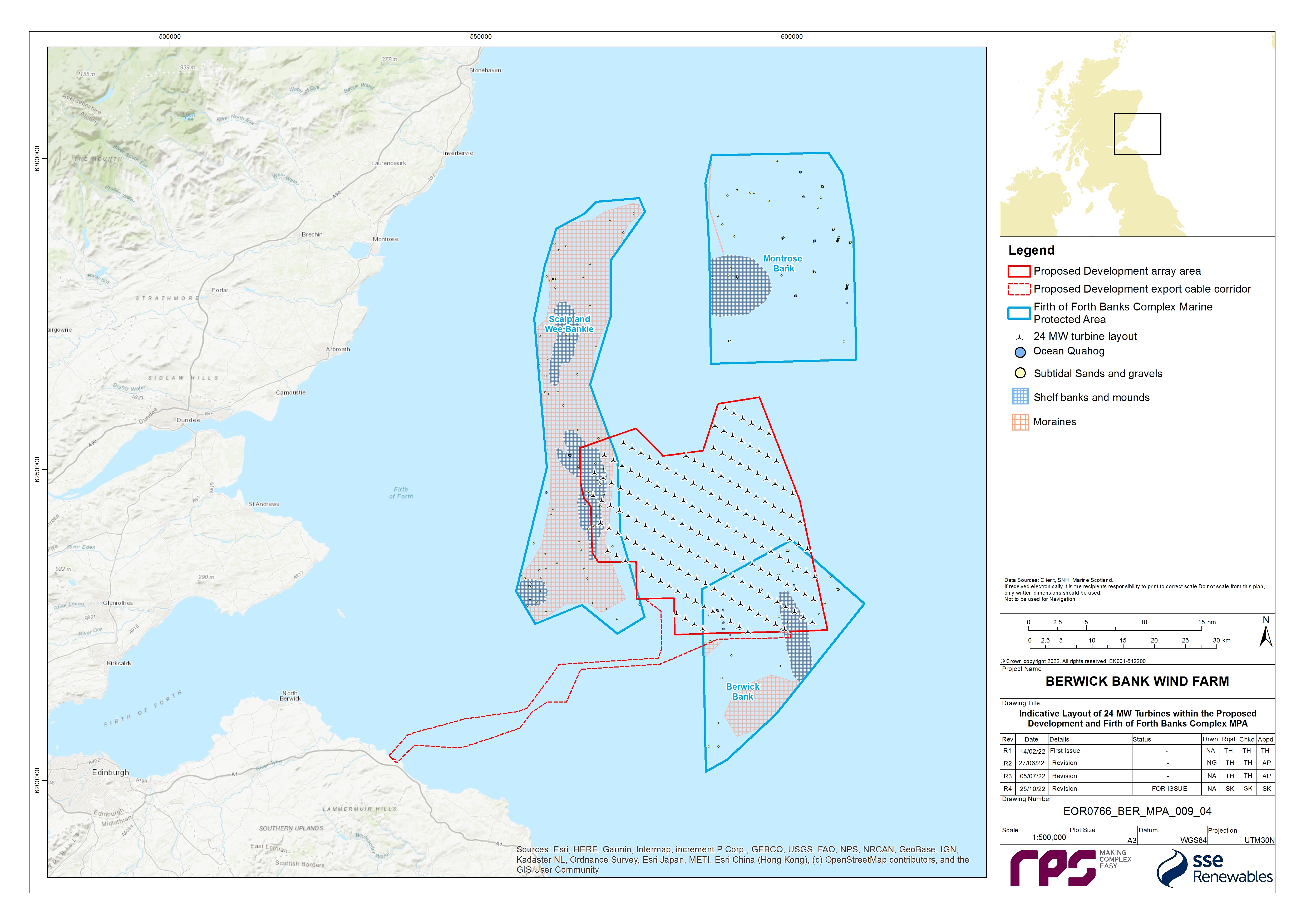
![]()
Offshore subtidal sands and gravels
- On the basis of the assumptions outlined in paragraph 190, and for the purposes of this assessment, it is assumed that all of the potential long term habitat loss (associated with the presence of wind turbine/OSP-Offshore convertor station platform foundations and scour protection) and long term habitat alteration (associated with cable protection for cables and cable crossings) will occur within this feature ( Table 1.42 Open ▸ ). This equates to 1.96 km2 and 0.09% of the total extent of the offshore subtidal sands and gravels feature. Of this 0.61 km2 will occur within Scalp and Wee Bankie (0.03% of the area of this feature in the MPA) and 1.36 km2 in the Berwick Bank part of the MPA (0.06% of the area of this feature in the MPA); see Table 1.43 Open ▸ .
- The installation of infrastructure resulting in long term habitat loss and habitat alteration will commence during the 96 month construction phase and will continue for the full 35 year operation and maintenance phase.
- The biotopes identified in association with the offshore subtidal sands and gravel feature, as described previously in paragraphs 203 and 204, have a high sensitivity to the pressure of ‘physical change to another substratum’. As these biotopes are typically characterised by infaunal species the physical change to another substrate type, i.e. the hard surface of foundations and cable protection for cables and cable crossings, would not allow for the continued presence of these communities at those locations, therefore they are highly intolerant of changes to new substrate. The long term habitat loss and alteration, however, represents only 0.09% of the Firth of Forth Banks Complex MPA therefore the impact on this feature within the regional ecosystem will be small, representing a highly localised change in community.
- Based on the information presented above, the following can be concluded with respect to the physical attributes of the offshore subtidal sands and gravels feature of the Firth of Forth Banks Complex MPA:
- The extent and distribution of offshore subtidal sands and gravels feature will be largely maintained within the MPA. While the Proposed Development is predicted to result in long term habitat loss and alteration of a very small proportion of the protected feature (i.e. up to 0.09% of the offshore subtidal sands and gravels feature; see Table 1.43 Open ▸ ), the effect will be highly localised to discrete areas within the MPA. The majority will be habitat alteration associated with cable protection for cables and cable crossings which represents a shift in substrate type rather than a total loss of habitat. It can be assumed that epifaunal communities will in time colonise these areas, potentially providing some recovery of communities in areas where cable protection for cables and cable crossings is placed and reducing the extent of long term habitat loss in the MPA. This is consistent with the ‘conserve’ objective of the extent and distribution attribute for this feature.
- The hydrodynamic regime is key to a number of the physical and biological attributes of this feature, the long term loss or alteration of habitat will not be a contributor to any change in the prevailing regime as the change is of such a limited impact. Sediment transport may be minorly altered with changes in residual current and sediment transport of approximately ±15% which is largely sited within close proximity to the wind turbine foundation structures, however this is considered unlikely to impact upon this large-scale feature as the effects will be highly localised. This is consistent with the ‘conserve’ objective of the supporting processes attribute for this feature.
- The fine scale topographic features within this habitat will be minimally impacted by the long term habitat loss and alteration as they rely on supporting processes such as sediment transport enabled by the prevailing hydrodynamic regime which, as discussed above, will remain predominantly unchanged as a result of long term habitat loss and alteration. Any minor changes to substrate availability or hydrodynamic regime may impact on sand ripples but on a small scale. The larger banks and mounds feature is too large to be impacted by changes of this magnitude (see paragraphs 272 to 275 and 397 for more detail). This is consistent with the ‘recover’ objective of the structure and function attribute for this feature.
- The sediment composition of this site involves a range of substrate, the loss and alteration of this substrate in 0.09% of the MPA area is unlikely to result in a change to the sediment composition of this large scale feature, especially as the hydrodynamic regime which enables sediment transport into this feature remains functional. The seabed infrastructure will be deployed in discrete areas with only a localised effect on sediment transport but unlikely to result in changes to sediment composition. This is consistent with the ‘recover’ objective of the structure and function attribute for this feature.
- The key and influential species of this protected feature will be minimally impacted by the loss of a small proportion of their habitat and are likely to maintain their populations throughout the construction and operation and maintenance phases of the Proposed Development. The majority of the (i.e. >99%) of this protected feature within the Firth of Forth Banks Complex MPA will be unaffected by long term habitat loss or alteration. This is consistent with the ‘recover’ objective of the structure and function attribute for this feature.
- The characteristic communities associated with this feature will, overall, be maintained following the placement of infrastructure, as only a small proportion of this habitat (0.09%) will be affected in discrete locations. Due to these localised impacts and the wide extent of this feature, the characteristic communities are likely to be maintained throughout the feature. This is consistent with the ‘recover’ objective of the structure and function attribute for this feature.
- The function of the feature depends upon a combination of a number of the attributes discussed above (paragraphs 297 and 298). The biological productivity of this feature will not be disturbed as it is controlled by the upwelling currents which are a part of the hydrodynamic regime which will be unaffected by long term habitat loss and habitat alteration. The small scale and localised nature of the impact (0.09% of total area of this feature) will enable the feature to retain its function as it pertains to climate regulation. Applying these effects to the features function as a spawning ground and feeding ground for commercial species, volume 2, chapter 9 of the Offshore EIA Report found sandeels to be the most sensitive any long term habitat loss due to their preference for sandy habitats and laying their eggs on the seabed. However, monitoring at Horns Rev I, located off the Danish coast, has indicated that the presence of operational wind farm structures has not led to significant adverse effects on sandeel populations in the long term (van Deurs et al., 2012; Stenberg et al., 2011). Initial results of a pre to post-construction monitoring study have reported that in some areas of the Beatrice Offshore Wind Farm, there was an increase in sandeel abundance (BOWL, 2021). These studies provide encouraging evidence to support the conservancy of this function across the feature. Volume 2, chapter 9 of the Offshore EIA Report also discusses monitoring from a Belgian offshore wind farm which reported that fish assemblages do not experience drastic changes due to the presence of offshore wind farms (Degraer et al., 2020). This is consistent with the ‘recover’ objective of the structure and function attribute for this feature.
- Volume 2, chapter 8 of the Offshore EIA Report concluded that due to the limited extent of the impact of long term habitat loss and alteration, and the relatively small proportion of the protected features to be affected during operation and maintenance, the magnitude of the impact on the features of the Firth of Forth Banks Complex MPA was low. The offshore subtidal sands and gravels protected feature of the Firth of Forth Banks Complex MPA is considered to be of high vulnerability, low recoverability and national importance and therefore was considered to have a high sensitivity. Therefore, the significance of effect was considered to be minor adverse.
- Based on the information presented here, it can be concluded that long term habitat loss and habitat alteration during the Proposed Development construction and operation and maintenance phase will not lead to a significant risk of hindering the achievement of the overall conservation objective for the offshore subtidal sands and gravels (i.e. “recover to favourable condition”) feature of the Firth of Forth Banks Complex MPA for the following reasons:
- Long term habitat loss and habitat alteration is predicted to affect a very small proportion of the habitat feature (0.09%) over the duration of the construction and operation and maintenance phase. This feature will, therefore, maintain its extent, and distribution; and
- The structures and functions, quality, and the composition of characteristic communities will remain in (or recover to) a condition which is healthy and not deteriorating. Only a small proportion of the overall habitat will become unavailable to the characteristic communities. The key and influential species are predicted to recolonise the areas around the new infrastructure, with full recovery of characteristic communities following the decommissioning of some infrastructures. These communities will be supported by an undisturbed hydrodynamic regime which will continue to form the fine scale features of the MPA.
Shelf banks and mounds
- On the basis of the assumptions outlined in paragraph 191, and for the purposes of this assessment, it is assumed that 19.48% of the maximum long term habitat loss and habitat alteration associated with the Proposed Development within the MPA could occur in this feature. This would result in a maximum of 0.38 km2 of long term habitat loss/alteration within the Firth of Forth Banks Complex MPA (this impact can be divided by activity, the figures for which are in Table 1.43 Open ▸ ). This would equate to this long term habitat loss and alteration of up to 0.14% of the total extent of this protected feature within the MPA. Of this, up to 0.27 km2 may occur within Scalp and Wee Bankie (0.10% of the total area of the feature in the MPA) and up to 0.12 km2 may occur within the Berwick Bank section of the MPA (0.04% of the total area of the feature in the MPA) (see Table 1.43 Open ▸ ).
- The duration of the habitat loss and alteration is detailed in paragraph 295 and the biotopes and their sensitivity are the same as for the offshore subtidal sand and gravel feature (paragraph 296).
- Based on the information presented above, the following can be concluded with respect to the physical and biological attributes of the protected features of the Firth of Forth Banks Complex MPA:
- The extent and distribution of the shelf banks and mounds feature would be largely maintained as only a very small proportion of the total extent of this feature will be affected by long term habitat loss and alteration (0.14%), preserving the majority of the feature. This is consistent with the ‘conserve’ objective of the extent and distribution attribute for this feature.
- The hydrodynamic regime of this area is not expected to be disrupted by long term habitat loss and alteration within this feature, enabling the sediment transport which forms these features to continue throughout the operation and maintenance phase of the Proposed Development, maintaining the supporting processes. Volume 2, chapter 7 of the Offshore EIA Report modelled changes to tidal and wave conditions of 2% at peak flow and <1% of wave height. Sediment transport may be minorly altered with changes in residual current and sediment transport of approximately ±15% which is largely sited within close proximity to the wind turbine foundation structures, however this is considered unlikely to impact upon this large-scale feature as the effects will be highly localised. This is consistent with the ‘conserve’ objective of the structure and function attribute for this feature.
- The physical nature of this protected feature formed by the hydrodynamic regime and sediment transport processes of the wider environment and as noted above neither the extent not supporting processes will experience major deterioration due to long term habitat loss and alteration. Instead, the minimal area of long term habitat loss/alteration and minimal disturbance of the hydrodynamic regime will enable the maintenance of the physical nature of the protected feature. This is consistent with the ‘conserve’ objective of the supporting processes attribute for this feature.
- Volume 2, chapter 8 of the Offshore EIA Report concluded that due to the limited extent of the impact of long term habitat loss and alteration, and the minor proportion of the protected features to be affected during operation and maintenance, the magnitude of the impact on the features of the Firth of Forth Banks Complex MPA was low. The shelf banks and mounds protected feature of the Firth of Forth Banks Complex MPA is considered to be of high vulnerability, low recoverability and national importance and therefore was considered to have a high sensitivity. Therefore, the significance of effect was considered to be minor.
- Based on the information presented here, it can be concluded that long term habitat loss and habitat alteration during the construction and operation and maintenance phases will not lead to a significant risk of hindering the achievement of the overall conservation objective for this feature of the Firth of Forth Banks Complex MPA (i.e. “maintain in favourable condition”) for the following reasons:
- Long term habitat loss and alteration is predicted to affect a very small proportion (0.14%) of the habitat feature over the duration of the construction phase within the MPA during the operation and maintenance phase. Therefore, the extent and distribution of the protected feature will be maintained;
- The function will remain in a condition which is healthy and not deteriorating due to the limited extent of habitat loss and alteration. This will ensure that the feature continues to support its characteristic biological communities and their use of the site for feeding, courtship, spawning, or use as nursery ground; and
- The supporting processes which enable the formation of these large features and create the necessary environmental conditions to enable its structure and function will be maintained.
Ocean quahog aggregations
- On the basis of the assumptions outlined in paragraph 190, and for the purposes of this assessment, it is assumed that all of the potential long term habitat loss occurring within the MPA (i.e. 1.96 km2) may occur within supporting habitat for ocean quahog aggregations (see Table 1.43 Open ▸ ) which would equate to a loss of 0.09% of supporting habitat for this protected feature within the MPA.
- The infrastructure resulting in long term habitat loss will be installed in the construction phase and remain present for the full 35 year operation and maintenance phase.
- The ocean quahog aggregations protected feature is expected to have a high sensitivity to physical change to another substratum. This is because they rely upon their sedimentary habitat for feeding as suspension/deposit feeders as well as shelter from predators and high energy currents by burrowing. Ocean quahogs would be intolerant of replacing this habitat with hard structure (Tyler-Walter and Sabatini, 2017).
- The installation of the infrastructure associated with the Proposed Development may, however, have some beneficial effects on ocean quahog, As discussed in paragraph 221, there will be no safety zones enforced during the operation and maintenance phase (except during maintenance events), however a 50 m safe passing distance for logistical and safety reasons (i.e. to account for the offset/drifting of fishing gear that happens as a result of the tide) can be assumed for fishing vessels in the vicinity of wind turbines. As a result, ocean quahog in the vicinity of the offshore infrastructure may potentially experience a reduced level of disturbance from commercial fishing in the long term (i.e. over the operational lifetime of the Proposed Development and potentially beyond), which may aid with the recovery of the wider population to the impact of habitat loss.
- Based on the information presented above, the following can be concluded with respect to the physical and biological attributes of the protected features of the Firth of Forth Banks Complex MPA:
- The extent and distribution of ocean quahog aggregations largely be maintained despite the loss of a very small portion of supporting habitat (0.09%) within the entire MPA. This will minimise as far possible the change in substrate type across the MPA. Beyond this initial loss of habitat, ocean quahog aggregations will still be provided with a stable environment in which to feed and reproduce with no major ongoing disturbance from the infrastructure. This is consistent with the ‘conserve’ objective of the extent and distribution attribute for this feature.
- The structure of the ocean quahog aggregations is dependent on the continued ability of ocean quahogs to reproduce at the site. The small proportion of habitat loss will not result in any long term impacts upon ocean quahogs to reproduce in the area as >99% of suitable habitat will be maintained. Furthermore, as noted in paragraph 309, a likely reduction in fishing pressure in the immediate vicinity of the wind turbines will likely aid the recovery of the ocean quahog population within the MPA. This is consistent with the ‘conserve’ objective of the structure and function attribute for this feature.
- The long term loss of habitat will not change the prevailing hydrodynamic conditions of the site however it may cause a localised change in sediment transport and a very small change to wave and tidal conditions (paragraphs 297 and 303), the limited scale of these changes is unlikely to compromise the conditions which ocean quahog rely upon. This is consistent with the ‘conserve’ objective of the supporting processes attribute for this feature.
- The continued availability of suitable habitat due to limited long term habitat loss, as well as minimal disturbance to its supporting processes will maintain the habitats which support ocean quahog aggregations. This is consistent with the ‘conserve’ objective of the structure and function attribute for this feature.
- While there is no evidence of the function that ocean quahog aggregations provide there are a number of potential examples to consider (JNCC, 2018b). The maintenance of the population structure and extent within the MPA contributes to the food web providing food for a number of fish and invertebrate species as well as providing a link for the recycling of nutrients between the pelagic and benthic environments. The highly limited extent of the impact also prevents damage to the features function as a carbon store by ensuring the majority of sediment is undisturbed. Overall, by maintaining the population throughout the MPA through minimal habitat loss ocean quahogs can continue to be studied in relation to historical environmental change and pollution. This is consistent with the ‘conserve’ objective of the structure and function attribute for this feature.
- Volume 2, chapter 8 of the Offshore EIA Report concluded that due to the limited nature of the impact of long term habitat loss, and the minor proportion of the protected features to be affected during operation and maintenance, the magnitude of the impact on the features of the Firth of Forth Banks Complex MPA was low. The ocean quahog protected feature of the Firth of Forth Banks Complex MPA is considered to be of high vulnerability, low recoverability and national importance and therefore was considered to have a high sensitivity. Therefore, the significance of effect was considered to be of minor adverse significance.
- Based on the information presented here, it can be concluded that long term habitat loss/habitat alteration during the construction and operation and maintenance phases will not lead to a significant risk of hindering the achievement of the overall conservation objective for this feature of the Firth of Forth Banks Complex MPA (i.e. “recover to favourable condition”) for the following reasons:
- Long term habitat loss is predicted to affect a very small proportion (0.09%) of supporting habitat for ocean quahog during the operation and maintenance phase, but the quality and quantity of ocean quahog habitat will be maintained. Whilst some ocean quahog individuals may be directly affected by the loss of habitat, this is predicted to be to an extent that will not affect the composition of its population in terms of number, age and sex ratio or its ability to thrive in the future and a likely reduction in fishing pressure in the immediate vicinity of the wind turbines will potentially aid the recovery of the ocean quahog population within the MPA.
Wee Bankie key geodiversity area (moraines)
- On the basis of the assumptions outlined in paragraph 192, and for the purposes of this assessment, it is assumed that 22.17% of the maximum long term habitat loss/habitat alteration predicted to occur within the MPA could occur in this feature. This equates to a maximum of 0.44 km2 of long term habitat loss within the Wee Bankie Key Geodiversity Area, or 0.06% of the total area of this feature within the MPA. Of this, up to 0.43 km2 may occur within Scalp and Wee Bankie (0.0575% of the total area of this feature within the MPA) and up to 0.002 km2 may occur within the Berwick Bank part of the MPA (0.0003% of the total area of this feature within the MPA) (see Table 1.43 Open ▸ ).
- Based on the information presented above, the following can be concluded with respect to the physical and biological attributes of the Wee Bankie Key Geodiversity Area feature of the Firth of Forth Banks Complex MPA:
- The extent and distribution of the Wee Bankie Key Geodiversity Area (Moraines) feature will be largely maintained throughout the operation and maintenance phase through the preservation of >99% of the protected feature. A very small proportion (0.06%) of the feature may experience long term habitat loss and alteration as a result of cable protection for cables and cable crossings and wind turbines/OSP-Offshore convertor station platform foundations however these areas will be discrete and localised and not impact on the overall large-scale distribution of the feature. This is consistent with the ‘conserve’ objective of the extent and distribution attribute for this feature.
- The structure of the protected feature was determined during the last glaciation and resulted in the moraines extending ~20 m above the surrounding seabed, with a width of ~20 km and a length of ~70 km. The highly limited extent of habitat loss and alteration within this feature (0.06%) will result in a near negligible impact on its structure. This is consistent with the ‘conserve’ objective of the structure and function attribute for this feature.
- The function of the moraines lies in their scientific study and the habitat they provide. The limited extent of habitat loss and alteration will not result in structural or extent change enabling scientific study of this feature to continue through the operation and maintenance phase. Additionally, the introduction of wind turbine/OSP-Offshore convertor station platform foundations and scour/cable protection for foundations, cables and cable crossings will not result in large scale changes to the structural composition of the sand and gravel-based feature, and it will still be able to complete its function as a habitat to sedimentary communities. This is consistent with the ‘conserve’ objective of the structure and function attribute for this feature.
- Based on the information presented here, it can be concluded that long term habitat loss/alteration during the construction and operation and maintenance phases will not lead to a significant risk of hindering the achievement of the overall conservation objective for the Wee Bankie Key Geodiversity Area feature of the Firth of Forth Banks Complex MPA (i.e. “maintain in favourable condition”) for the following reasons:
- Long term habitat loss and alteration is predicted to affect a very small proportion (0.06%) of the protected feature during the operation and maintenance phase. Overall, the extent, component elements and integrity as a relict feature within the MPA will be maintained;
- The structure and function will remain unimpaired by the activities as only a small proportion of the feature will be affected by the long term habitat loss and alteration impact; and
- The surface of the feature will remain sufficiently unobscured due to the limited extent of the impact as a proportion of the overall feature within the MPA.
Decommissioning phase
The maximum design scenario for permanent habitat alteration during the Proposed Development decommissioning phase assumes that all offshore infrastructure will be removed except for scour protection and some cable protection for cables and cable crossings, which, it is assumed for the purposes of this assessment, will be left in situ. Cable protection for cables and cable crossings and scour protection will be fully removed where it is possible and appropriate to do so noting this will depend on the type of protection used and condition of the protection at the time of removal. Cables will be removed where it is possible and appropriate to do so. As it is difficult to determine the proportion of cable protection for cables and cable crossings which will be removed it has been assumed as a maximum design scenario that all cable protection for cables and cable crossings will remain in situ. The Applicant will however continue to discuss the need for, and feasibility of, the removal of scour and cable protection for cables and cable crossings in sensitive areas such as the MPA as the Proposed Development progresses, with any final plans taking account of best practice at the time of decommissioning. Assessments will be updated accordingly to take account of any such discussions ahead of the final application. Table 1.46 Open ▸ presents the maximum design scenario for long term habitat loss and habitat alteration within the Firth of Forth Banks Complex MPA.
1 For the purposes of replicating the calculations in this table, 31.33% is calculated as 316.5 km2/1010.2 km2 (i.e. overlap between Proposed Development array area / total Proposed Development array area).
2 For the purposes of replicating the calculations in this table, 13.08% is calculated as 114.08 km/872 km (i.e. proportion of total length of offshore export cables that could occur within the part of the Proposed Development export cable corridor that overlaps with the MPA).
- On the basis of the assumptions outlined in paragraph 189, there may be up to 1.89 km2 of permanent habitat alteration within the Firth of Forth Banks Complex MPA following the decommissioning phase, equating to 0.09% of the total area of the MPA. Of this total, up to 0.58 km2 may occur within the Scalp and Wee Bankie section (0.03% of its total area of the MPA or 0.07% of the area of Scalp and Wee Bankie) and up to 1.31 km2 within the Berwick Bank part of the MPA (0.06% of its total area of the MPA or 0.24% of the area of Berwick Bank); see Table 1.45 Open ▸ .
Table 1.45: Summary of the Extent of Permanent Habitat Alteration within the Firth of Forth Banks Complex MPA (as a Whole, and for the Component Sites) Following the Decommissioning Phase
1 Calculated as 30.81% of the 1.89 km2 total on the basis of the overlap with the Scalp and Wee Bankie (see paragraph 170).
2 Calculated as 69.19% of the 1.89 km2 total on the basis of the overlap with the Berwick Bank (see paragraph 188).
3 Calculated as 43.82% of total 0.58 km2 of disturbance within the Scalp and Wee Bankie section (i.e. 43.82% of the total area of Scalp and Wee Bankie that overlaps with the Proposed Development and contains the shelf banks and mounds feature).
4 Calculated as 8.64% of total 1.31 km2 of disturbance within the Berwick Bank section (i.e. 8.64% of the total area of Berwick Bank that overlaps with the Proposed Development and contains the shelf banks and mounds feature).
5 Calculated as 71.59% of total 0.58 km2 of disturbance within the Scalp and Wee Bankie section (i.e.71.59% of the total area of Scalp and Wee Bankie that overlaps with the Proposed Development and contains the moraines feature).
6 Calculated as 0.16% of total 1.31 km2 of disturbance within the Berwick Bank section (i.e. 0.16% of the total area of Berwick Bank that overlaps with the Proposed Development and contains the moraines feature).
Offshore subtidal sands and gravels
- On the basis of the assumptions outlined in paragraph 190, and for the purposes of this assessment, it is assumed that up to 1.89 km2 of permanent habitat alteration may persist within the offshore subtidal sands and gravels feature of the Firth of Forth Banks Complex MPA following the decommissioning phase. This equates to 0.09% of the total area of this feature within the Firth of Forth Banks Complex MPA. Of the total area of seabed which will be affected, up to 0.58 km2 may be within Scalp and Wee Bankie (0.03% of the total area of the feature within the MPA) and up to 1.31 km2 will occur within the Berwick Bank part of the MPA (0.06% of the total area of the feature within the MPA) (see Table 1.45 Open ▸ ).
- An assessment of the impact of long-term habitat loss for this protected feature is presented in paragraph 297. This assessment is directly applicable to the decommissioning phase of the Proposed Development. In the decommissioning phase however, there will be a reduction the total area of habitat loss compared to the operation and maintenance phase (as foundations will be removed) which will reduce the extent of the impact on this feature, with some habitat recovering where infrastructure was removed. Furthermore, it can be assumed that epifaunal communities will in time colonise the cable and scour protection, potentially providing some recovery of communities in areas where cable protection for cables and cable crossings is placed and reducing the extent of permanent habitat alteration in the MPA.
- Additionally, the impact on the hydrodynamic regime in the decommissioning phase was modelled in volume 2, chapter 7 of the Offshore EIA Report and was found to have a reduced magnitude compared to the operational and maintenance phase as there will be no structures remaining in the water column after the removal of wind turbines/OSP-Offshore convertor station platform foundations. Overall, the chapter found the impact of the infrastructure on the wave and tidal currents to be negligible, resulting in the no change to the hydrodynamic regime from the pre-construction baseline in the long term/permanent basis in relation to permanent habitat alteration, which helps to conserve other elements such as supporting processes, function, and distribution of features.
- Volume 2, chapter 8 of the Offshore EIA Report concluded that due to the limited extent of the impact of permanent habitat alteration following decommissioning, and the relatively small proportion of the protected features to be affected during decommissioning, the magnitude of the impact on the features of the Firth of Forth Banks Complex MPA was low. The offshore subtidal sands and gravels protected feature of the Firth of Forth Banks Complex MPA is considered to be of high vulnerability, low recoverability and national importance and therefore was considered to have a high sensitivity. Therefore, the significance of effect was considered to be minor adverse significance.
- Based on the information presented here, it can be concluded that permanent habitat alteration as a result of the cable and scour protection remaining in situ following decommissioning will not lead to a significant risk of hindering the achievement of the conservation objectives for this feature of the Firth of Forth Banks Complex MPA for the reasons detailed in paragraph 300. Principally the overall extent and integrity of the feature will not be hindered as a result of this impact allowing for the unimpaired study of the feature.
Shelf banks and mounds
- On the basis of the assumptions outlined in paragraph 191, and for the purposes of this assessment, it is assumed that 19.48% of the maximum permanent habitat alteration within the MPA could occur in this feature. This would result in a maximum of 0.37 km2 of permanent habitat alteration within this feature which equates to 0.14% of the total area of the shelf banks and mounds feature within the MPA. Of this, up to 0.26 km2 may occur within Scalp and Wee Bankie (0.10% of the total area of the feature within the MPA) and up to 0.11 km2 may occur within the Berwick Bank section of the MPA (0.04% of the total area of the feature within the MPA) (see Table 1.45 Open ▸ ).
- An assessment of the impact of permanent habitat alteration for this protected feature during the operation and maintenance phase is presented in paragraphs 294 to 302. The differences between the decommissioning phase and the operational phase are described in paragraph 318. The reduced area of the impact, and potential for recovery where infrastructure was removed, and the associated negligible impact on the hydrodynamic regime both will contribute to the conservation of this protected feature.
- Volume 2, chapter 8 of the Offshore EIA Report concluded that due to the limited extent of the impact of permanent habitat alteration, and the minor proportion of the protected features to be affected during decommissioning, the magnitude of the impact on the features of the Firth of Forth Banks Complex MPA was low. The shelf banks and mounds protected feature of the Firth of Forth Banks Complex MPA is considered to be of high vulnerability, low recoverability and national importance and therefore was considered to have a high sensitivity. Therefore, the significance of effect was considered to be minor adverse significance.
- Based on the information presented here, it can be concluded that permanent habitat alteration following the decommissioning phase, within the shelf banks and mounds feature, will not lead to a significant risk of hindering the achievement of the conservation objectives for this feature of the Firth of Forth Banks Complex MPA for the reasons detailed in paragraph 305.
Ocean quahog aggregations
- On the basis of the assumptions outlined in paragraph 190, and for the purposes of this assessment, it is assumed that all of the permanent habitat alteration that may occur in the Firth of Forth Banks Complex MPA in the decommissioning phase may occur within this protected feature. Up to 1.89 km2 of permanent habitat alteration may persist within supporting habitat for ocean quahog within the Firth of Forth Banks Complex MPA following the decommissioning phase. This equates to 0.09% of the total area of this feature within the Firth of Forth Banks Complex MPA. Of the total area of seabed which will be affected, up to 0.58 km2 may be within Scalp and Wee Bankie (0.03% of the total area of the feature within the MPA) and up to 1.31 km2 will occur within the Berwick Bank part of the MPA (0.06% of the total area of the feature within the MPA) (see Table 1.45 Open ▸ ). Whilst this has been described here as habitat alteration with respect to the supporting subtidal sands and gravels habitats, it is noted that this would effectively represent a reduction in the extent of soft sediment habitat available for colonisation by ocean quahog in the post-decommissioning phase.
- An assessment of the impacts of permanent habitat alteration for this protected feature can be found in paragraph 310. This assessment is directly applicable to this phase of the Proposed Development. The changes in the magnitude of the impact are described in paragraph 318. These changes will result in a reduced pressure on ocean quahog aggregations and provide greater habitat with a negligible impact on the surrounding environment and its supporting processes.
- Volume 2, chapter 8 of the Offshore EIA Report concluded that due to the limited nature of the impact of permanent habitat loss, and the minor proportion of the protected features to be affected during decommissioning, the magnitude of the impact on the features of the Firth of Forth Banks Complex MPA was low. The ocean quahog protected feature of the Firth of Forth Banks Complex MPA is considered to be of high vulnerability, low recoverability and national importance and therefore was considered to have a high sensitivity. Therefore, the significance of effect was considered to be of minor adverse significance.
- Based on the information presented here, it can be concluded that permanent habitat alteration, as a result of scour and cable protection for cables and cable crossings being left in situ following decommissioning, will not lead to a significant risk of hindering the achievement of the conservation objectives for this feature of the Firth of Forth Banks Complex MPA for the reasons detailed in paragraph 312.
Wee Bankie key geodiversity area
- On the basis of the assumptions outlined in paragraph 192, and for the purposes of this assessment, it is assumed that 22.17% of the maximum permanent habitat alteration resulting from scour and cable protection being left in situ could occur in this feature. This equates to a maximum of 0.42 km2 of permanent habitat alteration within the Wee Bankie Key Geodiversity Area, or 0.06% of the total area of this feature within the MPA. Of this up to 0.417 km2 may occur within Scalp and Wee Bankie (0.06% of the total area of the feature within the MPA) and 0.002 km2 may occur within the Berwick Bank section of the MPA (0.0003% of the total area of the feature within the MPA) (see Table 1.45 Open ▸ ).
- An assessment of the impact of permanent habitat alteration for this protected feature is presented in paragraph 314. The differences between the decommissioning phase and the operation and maintenance phase are described in paragraph 318. The Wee Bankie Key Geodiversity Area feature is unlikely to recover following the completion of decommissioning as the processes which formed this feature are no longer active and therefore the feature cannot recover to its previous state when some of the infrastructure is removed however it may become less obvious as it is filled in by the current sediment transport processes, but this sediment may not be representative of the original structure.
- In relation to the size of the feature (~750 km2), the loss of 0.06% of this area to permanent habitat alteration as a result of scour and cable protection for cables and cable crossings being left in situ is very small, and it can be concluded that during, and post, the decommissioning phase this will not lead to a significant risk of hindering the achievement of the conservation objectives for this feature of the Firth of Forth Banks Complex MPA for the same reasons detailed in paragraph 315.
Colonisation of Hard Structures
Operation and maintenance phase
- Colonisation of hard structures during the operation and maintenance phase of the Proposed Development within the Firth of Forth Banks Complex MPA may occur due to the presence of wind turbines/OSP-Offshore convertor station platform foundations and cable, cable crossing and scour protection. Table 1.46 Open ▸ details the components of the Proposed Development which will contribute to the colonisation of hard structures within the MPA. Full details of why the suction caisson jacket foundations and the smaller wind turbines represent the maximum design scenario for habitat creation are presented in annex A.
- This assessment is equivalent to the following pressures identified by JNCC's Advice on Operations for the Firth of Forth Banks Complex MPA for ‘Renewable Energy: offshore wind’ and ‘Power cables: laying burial and protection’ (JNCC, 2018c):
- physical change to another seabed type.
- The assumptions used to determine the proportion of hard substrate available to colonise within the Firth of Forth Banks Complex MPA is as described previously in paragraph 189.
- The maximum design scenario for the area of habitat creation arising from the introduction of new hard structures within the Firth of Forth Banks Complex amounts to a total of up to 2.72 km2 or 0.13% of the total area of the MPA. Of this, up to 0.84 km2 may occur within the Scalp and Wee Bankie section which equates to 0.04% of the total area of the MPA (or 0.10% of the area of Scalp and Wee Bankie) and 1.88 km2 within the Berwick Bank part of the MPA which equates to 0.09% of the total area of the MPA (or 0.35% of the area of Berwick Bank) ( Table 1.47 Open ▸ ).
Table 1.46: Extent of Habitat Creation within the Firth of Forth Banks Complex MPA During the Operation and Maintenance Phase
1 For the purposes of replicating the calculations in this table, 31.33% is calculated as 316.5 km2/1010.2 km2 (i.e. overlap between Proposed Development array area / total Proposed Development array area).
2 For the purposes of replicating the calculations in this table, 13.08% is calculated as 114.08 km/872 km (i.e. proportion of total length of offshore export cables that could occur within the part of the Proposed Development export cable corridor that overlaps with the MPA).
Table 1.47: Summary of the Extent of Hard Structures for Colonisation Within the Firth of Forth Banks Complex MPA (as a Whole, and for the Component Sites) During the Operation and Maintenance Phase
1 Calculated as 30.81% of the 2.71 km2 total on the basis of the overlap with the Scalp and Wee Bankie (see paragraph 170).
2 Calculated as 69.19% of the 2.71 km2 total on the basis of the overlap with the Berwick Bank (see paragraph 188).
Offshore subtidal sands and gravels
- On the basis of the assumptions outlined in paragraph 191, and for the purposes of this assessment, it is assumed that all of the potential new habitat creation occurring within the MPA will occur within this feature which would equate to 2.72 km2 of new hard habitat within this protected feature and affecting 0.13% of the total area of the feature ( Table 1.47 Open ▸ ). This can be broken down as up to 0.84 km2 within Scalp and Wee Bankie (0.04% of the total area of this feature in the MPA), and up to 1.88 km2 within the Berwick Bank part of the MPA (0.09% of the total area of this feature in the MPA).
- Colonisation of wind turbine/OSP-Offshore convertor station platform foundations, associated scour protection and cable protection for cables and cable crossings may have indirect adverse effects on the baseline communities and habitats due to increased predation on and competition with the existing soft sediment species. These effects are difficult to predict, especially as monitoring to date has focused on the colonisation and aggregation of species close to the foundations rather than broad scale studies.
- The biotopes which characterise this offshore subtidal sands and gravel feature (i.e. SS.SSa.CFiSa.ApriBatPo and SS.SSa.CFiSa.EpusOborApri; see paragraph 203) are predominantly soft sediment communities and the introduction of new hard substrate will represent a shift from the baseline conditions from soft substrate areas (i.e. sands and gravels) to hard substrate in the areas where infrastructure is present. This may produce some potentially beneficial effects, for example the likely increase in biodiversity and individual abundance of reef species and total number of species over time, as has been observed at the monopile foundations installed at Lysekil research site (a test site for offshore wind-based research, north of Gothenburg, Sweden) (Bender et al., 2020). Species which are typical of rocky and intertidal habitats are likely to be the ones to colonise the new hard substrate.
- Studies have also shown that there is potential for reef effects to occur in association with the hard structures such as wind turbine foundations and scour/cable protection for foundations, cables and cable crossings. The structural complexity of the substrate may provide refuge as well as increasing feeding opportunities for larger and more mobile species. The presence of mobile benthic organisms is thought to be dependent on sufficient food sources, cover of epibenthic communities and appropriate habitat with shelter opportunities to hide from predators (Langhamer, and Wilhelmsson, 2009). A study by Lefaible et al. (2019) identified that jacket foundations had higher densities and diversity (species richness) of species in closer vicinity of the wind turbines compared to a control and a monopile foundation. A study by Mavraki et al. (2020) of gravity-based foundation in the Belgian part of the North Sea found that higher food web complexity was associated with zones where high accumulation of organic material such as soft substrate or scour protection, suggesting potential reef effect benefits from the presence of the hard structures.
- The reef effect may be enhanced by the deposition of fouling material on the seabed. An investigation conducted at the research platform Forschungsplattformen in Nord- und Ostsee 1 FINO 1 in the south-western German Bight in the North Sea reported that yearly, 878,000 single shell halves from Mytilus edulis sink onto the seabed from the FINO 1 platform, thereby greatly extending the reef effects created by the construction of the offshore platform structure (Krone et al., 2013). Removal of marine growth from the wind turbine foundations may also cause debris to fall within the vicinity of the wind turbine foundation. It is likely that seaweed/algal material would disperse into the water column, with heavier material (e.g. mussels) being deposited within 10 m to 15 m of the foundation. This material has the potential to change the prevailing sediment type in the immediate vicinity of the wind turbines, and therefore extending the reef effect.
- Some studies however have shown that the installation and operation of offshore wind farms have no significant impact on the wider soft sediment environments beyond the immediate impact of the loss of habitat. De Backer et al. (2021) found that eight to nine years after the installation of C-power and Belwind offshore wind farms (offshore Belgium) that the soft sediment epibenthos underwent no drastic changes; and the species originally inhabiting the sandy bottom were still present and remained dominant in both wind farms. The most recent benthic post-construction monitoring data of wind turbine foundations from Beatrice offshore wind farm (APEM, 2021) found foundation colonisation of wind turbines has resulted in zonation on the foundation itself but had little influence on the sedimentary habitat below. In the immediate vicinity of the jacket foundation legs mobile species were present such as hermit crab Pagurus bernhardus, flatfish and the common sea urchin Echinus esculentus, which suggests the availability of food although no biological material was recorded on the seabed (this material may have been rapidly consumed or relocated due to tidal currents) (APEM, 2021). Additionally, some species frequently found on the foundation legs, e.g. dead man’s fingers Alcyonium digitatum and the keelworm Spirobranchus triqueter, could also be found on the sedimentary habitat such as sublittoral coarse sediment (APEM, 2021).
- In conclusion the installation of hard structures will result in the loss of some sedimentary habitat directly below it and with a small radius around it, however the remaining sedimentary habitat will not be continually degraded and will largely remain unchanged as a result of the introduction and colonisation of hard substrate. There may be some benefits for species which prefer hard substrates as a result of the reef effect, but this is unlikely to affect species which inhabit the offshore subtidal sands and gravels. As outlined in Table 1.59 Open ▸ , the Applicant is committed to engaging in discussions with Marine Scotland and the SNCBs to identify, and input to, strategic benthic monitoring of the colonisation of hard structures and impacts to surrounding soft sediments across wind farms off the east coast of Scotland, if available and proposed by Marine Scotland in order to validate the predictions of this assessment.
- The infrastructure resulting in the colonisation of hard substrates will remain in place throughout the operation and maintenance period of up to up to 35 years.
- The physical attributes extent and distribution, hydrodynamic regime and fine scale topography are not applicable to this impact because they cannot be affected by the introduction of a new biological community.
- Based on the information presented above, the following can be concluded with respect to the relevant physical attributes of the protected features of the Firth of Forth Banks Complex MPA:
- The sediment composition of the offshore subtidal sands and gravels has the potential to impacted in a limited capacity by the deposition of encrusted material, either through natural processes or scheduled cleaning of infrastructure such as wind turbine/OSP-Offshore convertor station platform foundations. This effect would be highly localised and would not produce enough material to change the overall sediment composition in the vicinity of the wind turbine/OSP-Offshore convertor station platform foundations. This is supported by evidence from Block Island wind farm in the United States of America, where monitoring found no strong gradients of change in sediment grain size within 30-90 m of the wind turbines (Hutchinson et al., 2020a). It is likely that seaweed/algal material released during maintenance/cleaning of the wind turbine/OSP-Offshore convertor station platform foundations would disperse into the water column, with heavier material (e.g. mussels) being deposited within 10-15 m of the foundation (Vattenfall Wind Power Ltd, 2018). An investigation conducted at the research platform Forschungsplattformen in Nord- und Ostsee 1 FINO 1 in the south-western German Bight in the North Sea reported that blue mussels Mytilus edulis were one of the dominant colonising species (Krone et al., 2013) and the deposition of their shells on the seabed under the platform provides a secondary substrate for the attachment of other epifaunal species (Norling and Kautsky, 2007). In the long term, the production of shell debris may have indirect effects on benthic ecology by leading to coarser, shell-dominated sediment and enriched structure diversity. The extent to which Mytilus colonisation and subsequent indirect effects may occur is highly dependent on the nature of the structures installed and site-specific effects (e.g. structures further offshore, outside the mussels’ range may be colonised less strongly). Any fine material generated as a result of the use of high-pressure jet washing to remove the encrusting fauna into the marine environment may result in a short‐term increase in suspended organic material in the water. This material would be expected to be rapidly dispersed on the following tides and under the prevailing hydrodynamic conditions. Overall, this level of deposition is unlikely to have an impact on the sediment composition very far beyond the immediate vicinity of the infrastructure. This is consistent with the ‘recover’ objective of the structure and function attribute for this feature.
- The key influential species of this protected feature are unlikely to be affected by the biological communities which will colonise the hard structures of the Proposed Development. This is because the communities which will colonise the hard structures will be adapted to hard substrates and therefore unlikely to colonise the sedimentary habitat which is occupied by the key and influential species, this is supported by the examples provided in paragraphs 339 and 342 which provide evidence to support the prediction that soft sediment species are not affected by the colonising communities at offshore wind farms (De Backer et al., 2021; APEM, 2021). Whilst some reef effects may result in expansion of taxa normally associated with hard substrates colonising areas of subtidal coarse sediment or subtidal sand, these effects are likely to be limited to the immediate vicinity of offshore structures and will not result in changes to the species composition of communities associated with the offshore subtidal sands and gravels feature across the wider MPA. This is consistent with the ‘recover’ objective of the structure and function attribute for this feature.
- As above the characteristic communities within this protected feature will be adapted to the sands and gravels of the feature, resulting in no cross over of habitat and therefore competition between them and the colonising communities. Some studies have also shown minor increases in the prevalence of some epifaunal species around offshore wind farm infrastructure as they can provide shelter and food to surrounding communities (Langhamer and Wilhelmsson, 2009) which could benefit species such as squat lobster Galathea intermedia and sea spider Callipallene brevirostris. This is consistent with the ‘recover’ objective of the structure and function attribute for this feature.
- The function of this protected feature is unlikely to be affected by the colonisation of hard structures. As there is no impact on the physical attribute of this feature it is unlikely that the climate regulation function and productivity of the feature will be negatively affected. Addressing the features function as a spawning ground for fish such as plaice and sandeels, the productivity of the site is maintained through the undisturbed hydrodynamic regime and the sediment composition will only be negligibly impacted in the vicinity (within 200 m where change to littoral currents is expected to be 5% of the baseline) of the infrastructure from the deposition of encrusted material however as mentioned above (paragraph 346) that will not change the composition of sediment far beyond the immediate vicinity of the infrastructure where fouling deposition may occur. Therefore, the vast majority (>99%) of the offshore sands and gravels feature will be maintained and will remain suitable for spawning. This is consistent with the ‘recover’ objective of the structure and function attribute for this feature.
- Volume 2, chapter 8 of the Offshore EIA Report concluded that due to the highly limited nature of the colonisation of hard substrate impact and the relatively small proportion of the protected features to be affected during operation and maintenance, the magnitude of the impact on the features of the Firth of Forth Banks Complex MPA was low. The offshore subtidal sands and gravels protected feature of the Firth of Forth Banks Complex MPA is considered to be of high vulnerability, low recoverability and national importance and therefore was considered to have a high sensitivity. Therefore, the significance of effect was considered to be minor adverse significance.
- Based on the information presented here, it can be concluded that colonisation of hard substrate during the Proposed Development operation and maintenance phase will not lead to a significant risk of hindering the achievement of the overall conservation objective (i.e. “recover to favourable condition”) for this feature of the Firth of Forth Banks Complex MPA for the following reasons:
- Colonisation of hard substrate will not impact upon the extent and distribution of the protected feature and will therefore remain stable during the operation and maintenance phase; and
- The structures and functions, quality, and the composition of characteristic communities will remain in (or recover to) a condition which is healthy and not deteriorating. Seabed sediment will experience a small influx of deposited encrusted material, but the composition will not change. The key and influential species and their communities are not predicted to be affected other than potentially in the immediate vicinity of the wind turbine/OSP-Offshore convertor station platform foundations and scour protection and will therefore maintain their overall distribution and structure. These communities will be supported by an undisturbed hydrodynamic regime which will continue to form the fine scale features of the MPA.
Ocean quahog aggregations
- On the basis of the assumptions outlined in paragraph 190, and for the purposes of this assessment, it is assumed that all of the potential habitat creation occurring within the MPA (i.e. 2.72 km2) may occur within supporting habitat for ocean quahog aggregations ( Table 1.43 Open ▸ ), affecting 0.13% of the ocean quahog aggregations feature ( Table 1.47 Open ▸ ).
- The sensitivity of ocean quahog aggregations to the colonisation of hard structures is as discussed in paragraph 342. Studies suggests that the hard substrate adapted species which colonise offshore wind farm infrastructure will not have an impact on the soft sediment environment below and around them (De Backer et al., 2021; APEM, 2021).
- The infrastructure resulting in the colonisation of hard substrates will remain in place throughout the operation and maintenance period of up to up to 35 years.
- Based on the information presented above, the following can be concluded with respect to the physical and biological attributes of the protected features of the Firth of Forth Banks Complex MPA:
- The structure of ocean quahog aggregations is unlikely to be impacted upon by the colonisation of hard structures because the two communities are unlikely to interact in competition with each other due to their adaptations for distinctly different habitats, resulting in them posing no threat to larva, juvenile or adult forms of ocean quahogs which reside in the Firth of Forth Banks Complex MPA. Additionally, one potential form of interaction between communities, as discussed in paragraph 347, is the deposition of encrusted material from natural processes or scheduled cleaning. The effect is expected to be highly localised and unlikely to result in adverse effects on ocean quahogs due to their ability to de-bury themselves. This is consistent with the ‘conserve’ objective of the structure and function attribute for this feature.
- The supporting habitat of this feature is offshore subtidal sands and gravels and as explained in paragraph 347 the extent and distribution of this feature will not be affected by this impact and therefore continue to support ocean quahog aggregations throughout the Firth of Forth Banks Complex MPA. This is consistent with the ‘conserve’ objective of the extent and distribution attribute for this feature.
- There is not yet any direct evidence regarding the function of ocean quahogs however it is suggested that they could be a key part of the food web, act as a link between the benthic and pelagic environments, help carbon and nutrient cycling (Tyler-Walters and Sabatini, 2017) as well as being the subject of scientific study due to their ability to indicate climate and environmental change (Schöne, 2013). These functions will not be impacted due to the colonisation of hard substrate as >99% of ocean quahog habitat will be maintained throughout the operation and maintenance phase and any effect will be highly localised to the infrastructure enabling the conservation of ocean quahog aggregations in the similar number to pre-construction, allowing them to continue their ecological functions. This is consistent with the ‘conserve’ objective of the structure and function attribute for this feature.
- Volume 2, chapter 8 of the Offshore EIA Report concluded that due to the limited nature of the impact of colonisation of hard structures, and the minor proportion of the protected features to be affected during operation and maintenance, the magnitude of the impact on the features of the Firth of Forth Banks Complex MPA was low. The ocean quahog protected feature of the Firth of Forth Banks Complex MPA is considered to be of high vulnerability, low recoverability and national importance and therefore was considered to have a high sensitivity. Therefore, the significance of effect was considered to be of minor adverse significance.
- Based on the information presented here, it can be concluded that colonisation of hard structures during the Proposed Development operation and maintenance phase will not lead to a significant risk of hindering the achievement of the overall conservation objective for this feature of the Firth of Forth Banks Complex MPA (i.e. “recover to favourable condition”) for the following reasons:
- Colonisation of hard substrates is predicted to affect a small proportion (0.13%) of supporting habitat for ocean quahog during the operation and maintenance phase, but habitats are predicted to remain unaffected such that the quality and quantity of ocean quahog habitat is maintained. Whilst some ocean quahog individuals may be directly affected by operation and maintenance activities, this is predicted to be to an extent that will not affect the composition of its population in terms of number, age and sex ratio or its ability to thrive in the future.
Decommissioning phase
- The maximum design scenario for the extent of habitat creation arising from the introduction of new hard structures within the Firth of Forth Banks Complex MPA which will persist following the decommissioning phase of the Proposed Development amounts to a total of up to 1.87 km2 or 0.09% of the total area of the MPA. As outlined in
- Table 1.48 Open ▸ , this comprises scour and some cable protection for cables and cable crossings only, as the maximum design scenario assumes that all foundations will be removed during decommissioning. Of this habitat creation, up to 0.58 km2 may persist post-decommissioning within the Scalp and Wee Bankie section which equates to 0.03% of the total area of the MPA (or 0.07% of the area of Scalp and Wee Bankie) and 1.29 km2 within the Berwick Bank part of the MPA which equates to 0.06% of the total area of the MPA (or 0.24% of the area of Berwick Bank) (see Table 1.49 Open ▸ ).
- These effects are considered in the decommissioning phase as it takes time for organisms to colonise a structure post-installation and structures which are left in situ during and after decommissioning (i.e. scour and cable protection for cables and cable crossings) will continue to provide potential habitat for colonising species. Cable protection for cables and cable crossings will be fully removed where it is possible and appropriate to do so noting this will depend on the type of protection used and condition of the protection at the time of removal. All cables will be removed where it is possible and appropriate to do so. As it is difficult to determine the proportion of cable protection which will be removed it has been assumed as a maximum design scenario that all cable protection will remain in situ.
1 For the purposes of replicating the calculations in this table, 31.33% is calculated as 316.5 km2/1010.2 km2 (i.e. overlap between Proposed Development array area / total Proposed Development array area).
2 For the purposes of replicating the calculations in this table, 13.08% is calculated as 114.08 km/872 km (i.e. proportion of total length of offshore export cables that could occur within the part of the Proposed Development export cable corridor that overlaps with the MPA).
Table 1.49: Summary of the Extent of Hard Structures for Colonisation Within the Firth of Forth Banks Complex MPA (as a Whole, and for the Component Sites) Following the Decommissioning Phase
1 Calculated as 30.81% of the 1.87 km2 total on the basis of the overlap with the Scalp and Wee Bankie (see paragraph 170).
2 Calculated as 69.19% of the 1.87 km2 total on the basis of the overlap with the Berwick Bank (see paragraph 188).
- The risk associated with the decommissioning phase is reduced compared to the operation and maintenance phase assessment (by the equivalent of 0.05% of the total area of the MPA) as the maximum design scenario assumes that the wind turbine/OSP-Offshore convertor station platform foundations, which span the water column, will be removed which will result in a reduction in hard structures available for colonisation.
Offshore subtidal sands and gravels
- On the basis of the assumptions outlined in paragraph 190, and for the purposes of this assessment, it is assumed that all of the hard substrate which could remain in the MPA post-decommissioning (i.e. 1.87 km2 resulting from the continued presence of scour and cable protection for cables and cable crossings) would occur within this feature, affecting 0.09% of this protected feature.
- Despite the decrease in amount of hard infrastructure compared to the operation and maintenance phase, the overarching risks associated with this impact are as described in paragraphs 334 et seq., involving a physical change to the seabed type. The effects on the offshore subtidal sands and gravels protected feature are as described in paragraphs 339 to 347.
- Volume 2, chapter 8 of the Offshore EIA Report concluded that due to the highly limited nature of the colonisation of hard substrate impact and the relatively small proportion of the protected features to be affected during operation and maintenance, the magnitude of the impact on the features of the Firth of Forth Banks Complex MPA was low. The offshore subtidal sands and gravels protected feature of the Firth of Forth Banks Complex MPA is considered to be of high vulnerability, low recoverability and national importance and therefore was considered to have a high sensitivity. Therefore, the significance of effect was considered to be minor adverse significance.
- Based on the information presented in paragraphs 337 to 349, it can be concluded that the impact of habitat creation and the colonisation of structures (i.e. scour and cable protection for foundations, cables and cable crossings) persisting post-decommissioning will not lead to a significant risk of hindering the achievement of the conservation objectives (i.e. “recover to favourable condition”) for this feature of the Firth of Forth Banks Complex MPA for the reasons presented in paragraph 349.
Ocean quahog aggregations
- On the basis of the assumptions outlined in paragraph 190, and for the purpose of this assessment, it is assumed that all of the hard substrate which could remain in the MPA post-decommissioning (i.e. 1.87 km2 resulting from the continued presence of scour and cable protection for foundations, cables and cable crossings) will occur within supporting habitat for this feature, affecting 0.09% of the supporting habitat for this protected feature.
- Despite the decrease in amount of hard infrastructure compared to the operation and maintenance phase, the overarching risks associated with this impact are as described in paragraphs 334 et seq., involving a physical change to the seabed type. The effects on supporting habitat for this protected feature are as described in paragraphs 351 to 353.
- Volume 2, chapter 8 of the Offshore EIA Report concluded that due to the limited nature of the impact of colonisation of hard structures, and the minor proportion of the protected features to be affected during operation and maintenance, the magnitude of the impact on the features of the Firth of Forth Banks Complex MPA was low. The ocean quahog protected feature of the Firth of Forth Banks Complex MPA is considered to be of high vulnerability, low recoverability and national importance and therefore was considered to have a high sensitivity. Therefore, the significance of effect was considered to be of minor adverse significance.
- Based on the information presented in paragraphs 350 to 355, it can be concluded that the impact of habitat creation and the colonisation of structures (i.e. scour and cable protection for foundations, cables and cable crossings) persisting post-decommissioning will not lead to a significant risk of hindering the achievement of the conservation objectives (i.e. “recover to favourable condition”) for this feature of the Firth of Forth Banks Complex MPA for the reasons presented in paragraph 355.
Increased Risk of Introduction and Spread of INNS
Construction and operation and maintenance phase
- Increased risk of introduction and spread of INNS in subtidal habitat may occur within the Firth of Forth Banks Complex MPA during the construction and operation and maintenance phase as a result of the creation of hard substrates such as wind turbine/OSP-Offshore convertor station platform foundations, cable, and scour protection, as well as vessel trips for construction and maintenance. The maximum design scenario for increased risk of introduction and spread of INNS within the Firth of Forth Banks Complex MPA is the same as for colonisation of hard substrate ( Table 1.46 Open ▸ ), and also includes up to 11,484 vessel round trips during construction and 2,324 vessel round trips per year (81,350 over the 35 year lifetime) over the operation and maintenance phase.
- This assessment is equivalent to the following pressures identified by JNCC's Advice on Operations for the Firth of Forth Banks Complex MPA for ‘Renewable Energy: offshore wind’ and ‘Power cables: laying burial and protection’ (JNCC, 2018c):
- Introduction or spread of non-indigenous species.
- The assumptions used to determine the proportion of new hard substrate available for colonisation which occurs within the Firth of Forth Banks Complex MPA is stated in paragraph 189.
- The extent of habitat creation which may increase the risk of introduction and spread of INNS within the Firth of Forth Banks Complex MPA is the same as detailed in paragraph 336.
Offshore subtidal sands and gravels
- On the basis of the assumptions outlined in paragraph 190, and for the purposes of this assessment, it is assumed that all of the potential increased risk of introduction and spread of INNS will occur within this feature ( Table 1.43 Open ▸ ). This would equate to the introduction of 2.72 km2 of new hard substrate affecting 0.13% of this protected feature (the breakdown between sections of the MPA is presented in paragraph 337). Additionally, there is the risk associated with up to 11,484 vessel round trips during construction and up to 81,350 vessel round trips over the operation and maintenance phase (approximately 2,324 trips per year).
- Activities resulting in a potential increased risk of introduction and spread of INNS will occur throughout the 96 months of the construction phase as well as the operation and maintenance period of up to 35 years. Vessel movements are likely to be concentrated on discrete locations within the Firth of Forth Banks Complex MPA, where cable or wind turbine construction/repair/investigation may be required. In both the construction phase and operation and maintenance phase, the vessel movement will occur in all sections of the MPA which overlap with the Proposed Development but will be specific to the location of infrastructure. It should be noted that the existing baseline of vessel activity includes commercial fishing, cargo vessels and tankers which are found in this area on a daily basis. As outlined in section 193, designed in measures including an Environmental Management Plan (EMP) (including an INNS management plan) (volume 3 appendix 6.2 of the Offshore EIA Report) and vessels complying with International Maritime Organisation (IMO) ballast water management guidelines (IMO, 2004) throughout all phases of the Proposed Development will ensure that the risk of potential introduction and spread of INNS will be minimised.
- The sedimentary and high energy nature of the environment is however thought to be challenging for most INNS with very few species able to colonise mobile sands due to the high levels of sediment disturbance (Tillin, 2016a; Tillin, 2016b). Additionally, as discussed in paragraph 347 any INNS which colonise the hard structures of the wind turbine/OSP-Offshore convertor station platform foundations are unlikely to spread on to the sand and gravels of the seabed as they are not adapted for this habitat. Where this does occur, any effects are likely to be limited to the immediate vicinity of offshore structures and will not result in changes to the species composition of communities associated with the offshore subtidal sands and gravels feature across the wider MPA. Recent monitoring from Beatrice offshore wind farm, off of the north-western coast of Scotland, found no evidence of INNS colonisation on foundations (APEM, 2021).
- The characteristic biotopes of this protected feature (SS.SSa.CFiSa.EpusOborApri and SS.SSa.CFiSa.ApriBatPo) are most at risk from the introduction of slipper limpet Crepidula fornicata as this species can form dense carpets which can smother other species and prevent larva from settling (Tillin, 2016a; Tillin, 2016b). The long term presence of slipper limpets can also lead to the aggregation of suspended silt, faeces and pseudo-faeces altering the benthic habitat leading to a change in the dominant biotopes (Tillin, 2016a; Tillin, 2016b). Slipper limpets have been recorded, but only once, in the wider Firth of Forth/South-eastern Scotland region (NBN Atlas). This species spreads through ballast water transfer and hull fouling; however as mentioned in paragraph 373 and see section 193 designed in measures will be implemented to minimise the risk from these sources.
- Based on the information presented above, the following can be concluded with respect to the physical and biological attributes of the offshore subtidal sands and gravels feature of the Firth of Forth Banks Complex MPA:
- The sediment composition is unlikely to be impacted upon by the increased risk of introduction and spread of INNS. The various measures put in place, detailed in paragraph 373, alongside the high energy of the environment, minimise the risk of INNS introduction and therefore colonisation by any species which could change the sediment composition of a site. This is consistent with the ‘recover’ objective of the structure and function attribute for this feature.
- The key and influential species of this protected feature include ocean quahog which live on and in the sediment. Their sensitivity to INNS has not been assessed by the MarESA however their slow growth rate would suggest they are vulnerable to fast spreading INNS species. The nature of the features/activities causing an increased risk (new hard structures and the precise focus of vessel trips) as well as the measures put in place to reduce the transfer of ecological material between locations (see Table 1.36 Open ▸ ) will result in the risk associated with this impact being lowered and potentially damaging affects being limited. This is consistent with the ‘recover’ objective of the structure and function attribute for this feature.
- The factors considered above apply also to when considering the impact upon the characteristic communities of this protected feature. The characteristic communities of this protected feature rely up on the sedimentary environment it provides, therefore the reduction in the transfer of ecological material between locations is key to preserving these communities and maintaining their distribution throughout this feature. This is consistent with the ‘recover’ objective of the structure and function attribute for this feature.
- The physical functions of this feature, the biological productivity driven by hydrodynamic regime and the climate regulation of this feature will not be impacted by increased risk of INNS introduction or spread as the representative processes will be unaffected by relatively small-scale ecological change. The function of the site as a spawning ground has the potential to be affected by this impact. This functions likely to be affected due to the measures put in place to minimise ecological transfer between location reducing the likelihood of INNS introduction, especially as records of potential damaging INNS are very low in this area. This is consistent with the ‘recover’ objective of the structure and function attribute for this feature.
- Volume 2, chapter 8 of the Offshore EIA Report concluded that due to the highly limited nature of the increasing the risk of introduction and spread of INNS impact, and the relatively small proportion of the protected features to be affected during operation and maintenance, the magnitude of the impact on the features of the Firth of Forth Banks Complex MPA was low. The offshore subtidal sands and gravels protected feature of the Firth of Forth Banks Complex MPA is considered to be of high vulnerability, low recoverability and national importance and therefore was considered to have a high sensitivity. Therefore, the significance of effect was considered to be minor adverse significance, which is not significant in EIA terms.
- Based on the information presented here, it can be concluded that increasing the risk of introduction and spread of INNS during the Proposed Development operation and maintenance phase will not lead to a significant risk of hindering the achievement of the overall conservation objective (i.e. “recover to favourable condition”) for this feature of the Firth of Forth Banks Complex MPA for the following reasons:
- The risk of introduction and spread of INNS will not impact upon the extent and distribution of the protected feature and this will therefore remain stable during the construction and operation and maintenance phase; and
- The structures and functions, quality, and the composition of characteristic communities will remain in (or recover to) a condition which is healthy and not deteriorating. The measures put in place to minimise the transfer of ecological material as well as the limited record of INNS in this region the likelihood of damaging effects on key influential species and characteristic communities is minimal. These communities will be supported by an undisturbed hydrodynamic regime which will continue to form the fine scale features of the MPA.
- On the basis of the assumptions outlined in paragraph 190, and for the purpose of this assessment it is assumed that the increased risk of the introduction and spread of INNS will occur within this feature ( Table 1.43 Open ▸ ). This would equate to the introduction of up to 2.72 km2 of new hard substrate, affecting 0.13% of this protected feature (the breakdown between sections of the MPA is presented in paragraph 337). Additionally there is the risk associated with up to 11,484 vessel round trips during construction and up to 81,350 vessel round trips over the operation and maintenance phase (approximately 2,324 vessel round trips per year).
- Paragraphs 373 and 374 detail the nature of the impact in relation to vessel movement and the physical environment. Neither the FeAST or the MarESA provides evidence to justify the sensitivity of ocean quahogs to increased risk of introduction and spread of INNS. The biological characteristics of ocean quahog, such as the length of time taken to reach sexual maturity (~5 to 11 years; Thorarinsdóttir, 1999), make them vulnerable to potentially faster growing and spreading INNS which could out compete them in their own habitat.
- Based on the information presented above, the following can be concluded with respect to the physical and biological attributes of the protected features of the Firth of Forth Banks Complex MPA:
- The extent and distribution of ocean quahog is unlikely to be affected by the potential introduction and spread of INNS as a result of the measures put in place to limit the transfer of ecological material, detailed in paragraph 374, as well as the low number of INNS species recorded in this region, the majority of Scottish INNS species are found on the west coast. By limiting the introduction of INNS this will preserve the extent of the ocean quahogs distribution. This is consistent with the ‘conserve’ objective of the extent and distribution attribute for this feature.
- Through the proposed designed in measures (paragraph 373 and Table 1.36 Open ▸ ) and the nature of the risk posed by INNS, reducing the potential for the introduction of INNS the impact will help to preserve the structure of ocean quahogs aggregations by preventing any potential competition with INNS. Competition between INNS and ocean quahog could result in the loss of vulnerable individuals within the population (e.g. juveniles). By reducing the pathways through which introduction could occur the opportunity for potentially unfavourable competition is also reduced. This is consistent with the ‘conserve’ objective of the structure and function attribute for this feature.
- The supporting habitat for ocean quahog aggregations is the sedimentary habitat provided by the offshore subtidal sands and gravels feature. The sediment composition of this feature and therefore the supporting habitat are unlikely to be affected by this impact due to it’s the measures taken to limit the risk of introduction (paragraph 373). This is consistent with the ‘conserve’ objective of the structure and function attribute for this feature.
- There is not yet any direct evidence regarding the function of ocean quahogs however it is suggested that they could be a key part of the food web, act as a link between the benthic and pelagic environments, help carbon and nutrient cycling (Tyler-Walters and Sabatini, 2017) as well as being the subject of scientific study due to their ability to indicate climate and environmental change (Schöne, 2013). Through the preservation of its extent, structure and supporting habitats as detailed above the reduced risk of introduction of INNS ensures that any potential function such as food for commercial fish species, nutrient, and carbon cycling, and as a focus of scientific research, are able to continue. This is consistent with the ‘conserve’ objective of the structure and function attribute for this feature.
- Volume 2, chapter 8 of the Offshore EIA Report concluded that due to the limited nature of the increasing the risk of introduction and spread of INNS impact, and the minor proportion of the protected features to be affected during operation and maintenance, the magnitude of the impact on the features of the Firth of Forth Banks Complex MPA was low. The ocean quahog protected feature of the Firth of Forth Banks Complex MPA is considered to be of high vulnerability, low recoverability and national importance and therefore was considered to have a high sensitivity. Therefore, the significance of effect was considered to be of minor adverse significance.
- Based on the information presented here, it can be concluded that increasing the risk of introduction and spread of INNS during the Proposed Development operation and maintenance phases will not lead to a significant risk of hindering the achievement of the conservation objectives for this feature of the Firth of Forth Banks Complex MPA (i.e. “to recover to favourable condition”) for the following reasons:
- While there is an increased risk of introduction and spread of INNS during the construction and operation and maintenance phases to the ocean quahog aggregations protected feature, the designed in measures will reduce the risk and ensure the quality and quantity of the protected feature remain stable throughout the Proposed Developments phases. Ocean quahogs are unlikely to be directly affected by construction and operation and maintenance activities, and therefore will not affect the composition of its population in terms of number, age and sex ratio or its ability to thrive in the future.
Decommissioning phase
- Increased risk of the introduction and spread of INNS in subtidal habitat may occur within the Firth of Forth Banks Complex MPA during the decommissioning phase as a result of the presence of structures left in situ such as cable, and scour protection, as well as vessel trips for decommissioning. The maximum design scenario for the area affected by increased risk of introduction and spread of INNS within the Firth of Forth Banks Complex MPA is the same as for colonisation of hard substrate persisting post-decommissioning (paragraph 336 and Table 1.46 Open ▸ ), but also includes up to 11,484 vessel round trips during the decommissioning phase.
- The risk associated with the decommissioning phase is reduced compared to the operation and maintenance phase as most of the hard structures, including the wind turbine/OSP-Offshore convertor station platform foundations which span the water column, will be removed which will result in a reduction in hard structures available to INNS. However, as previously noted (paragraphs 368 to 383), these structures do not pose a serious risk to the protected feature within the Firth of Forth Banks Complex MPA as the species which are likely to colonise the structures would not be adapted to the sedimentary habitat which dominates the MPA. Additionally, this phase represents a larger number of vessel round trip over a shorter amount of time (should it be similar in time scale to the construction phase, although this is not confirmed), however these trips will be intermittent and have a precise focus on the removal of infrastructure as well as following the procedures described as part of the designed in measures for the Proposed Development ( Table 1.36 Open ▸ ).
Offshore subtidal sands and gravels
- On the basis of the assumptions outlined in paragraph 190, and for the purposes of this assessment, it is assumed that all the activities and infrastructure resulting in increased risk of introduction and spread of INNS will occur within this feature which would affect 0.09% of this protected feature, along with the risk associated with up to 11,484 vessel round trips.
- Despite the increase in vessel trips and decrease in amount of hard infrastructure the risks associated with this impact remain the same as described in paragraph 376 as the designed in measures (see Table 1.36 Open ▸ ) which will be implemented to reduce the risk (i.e. an EMP (including an INNS management plan) (volume 3, appendix 6.2 of the Offshore EIA Report) and vessels complying with IMO ballast water management guidelines), will remain in place.
- The conclusion reached by volume 2, chapter 8 of the Offshore EIA Report for the decommissioning phase is the same as was reached for the operation and maintenance phase (paragraph 377).
- Based on the information presented here, it can be concluded that increasing the risk of introduction and spread of INNS during the Proposed Development decommissioning phase will not lead to a significant risk of hindering the achievement of the conservation objectives (i.e. “recover to favourable condition”) for this feature of the Firth of Forth Banks Complex MPA for the same reasons presented in paragraph 378.
Ocean quahog aggregations
- On the basis of the assumptions outlined in paragraph 190, and for the purpose of this assessment it is assumed that all the activities and infrastructure resulting in increased risk of introduction and spread of INNS will occur within this feature which would affect 0.09% of this protected feature, along with the risk associated with up to 11,484 vessel round trips.
- Despite the increase in vessel trips and decrease in amount of hard infrastructure the risks associated with this impact remain the same as described in paragraph 373 as the designed in measures (see section 193) which will be implemented to reduce the risk (i.e. an EMP (including an INNS management plan) (volume 3, appendix 6.2 of the Offshore EIA Report) and vessels complying with IMO ballast water management guidelines), will remain in place.
- The conclusion reached by volume 2, chapter 8 of the Offshore EIA Report for the decommissioning phase is the same as was reached for the operation and maintenance phase (paragraph 381).
- Based on the information presented here, it can be concluded that increasing the risk of introduction and spread of INNS during the Proposed Development decommissioning phase will not lead to a significant risk of hindering the achievement of the conservation objectives (i.e. “recover to favourable condition”) for this feature of the Firth of Forth Banks Complex MPA for the same reasons presented in paragraph 383.
Alteration of Seabed Habitat Arising from Effects of Physical Processes
Operation and maintenance phase
- Alteration of seabed habitat arising from effects on physical processes during the operation and maintenance phase of the Proposed Development in the Firth of Forth Banks Complex MPA may occur as a result of the presence of wind turbine/OSP-Offshore convertor station platform foundations as well as cable protection for cables and cable crossings. Full detail on the project envelope assumptions and maximum design scenario with respect to foundation and cable installation as well as seabed clearance are provided in section 1.4.
- This assessment is equivalent to the following pressures identified by JNCC's Advice on Operations for the Firth of Forth Banks Complex MPA for ‘Renewable Energy: offshore wind’ and ‘Power cables: laying burial and protection’ (JNCC, 2018c):
- Water flow (tidal current) changes – local, including sediment transport considerations; and
- Wave exposure changes – local.
- Volume 2, chapter 7 and chapter 8 of the Offshore EIA Report provide a full description of the modelling including the assessment of alteration of seabed habitat arising from effects of physical processes.
- The presence of infrastructure within the offshore wind farm may lead to changes in tidal currents, wave climate, littoral current and sediment transport. The results of the modelling indicates that peak flow is redirected in the immediate proximity of structures by a maximum variation of less than 2% (maximum variation of 1 cm/s) of the peak flow and reduces significantly with distance from the structure. This impact may have a direct impact on the hydrodynamic regime and will persist for the entire lifetime of the Proposed Development, however these changes will be imperceptible and reversed after decommissioning. Changes in wave climate during a one in one year storm equate to <1% or 2 cm of the baseline significant wave height. For a 1 in 20 year storm the change is of a similar magnitude (2 cm to 4 cm change in wave height). Sediment transport is driven by both the tidal and wave regimes, the magnitude of both is described above. For a one in one year storm from 000o during the flood tide the tidal flow is reduced on the lee side of the structure further. However, during the ebb flow, the wave climate and tidal flow are in opposition reducing the magnitude of the littoral current. Overall, the magnitude of change compared to the baseline current flow is ±5% which would not be sufficient to disrupt beach and offshore bank morphological processes or destabilise coastal features. Residual currents are effectively the driver of sediment transport and therefore any changes to residual currents would have a direct impact on sediment transport which would persist for the lifecycle of the Proposed Development. The residual current and sediment transport was simulated with the foundations in place. The maximum change in residual current and sediment transport is circa ±15% within close proximity to the structure (i.e. as a result of the scour protection). The changes due to the presence of the foundations are very small beyond 200 m of the structure (within 200 m the changes were ±5%). The hydrodynamic regime is highly variable through tidal cycles and due to meteorological conditions, with the scale of the impact being well within the natural variation. The changes to tidal currents, wave climate, littoral currents, and sediment transport are insignificant in terms of the hydrodynamic regime and effects on tidal current and wave climate would be reversible on decommissioning (i.e. following removal of the wind turbine structures).
- Based on this information, the following can be concluded with respect to all of the physical attributes of all the protected features:
- Changes to wave and tidal climate are minimal and will only result in impacts in the immediate vicinity of infrastructure and will be reversed following decommissioning (following the removal of the wind turbine/OSP-Offshore convertor station platform foundations).
- The sediment transport regime will experience a maximum change of ±15% within close proximity to the structures as a result of the changes in tidal and wave conditions, however this change will also be very small beyond the immediate vicinity (i.e. within 200 m) of the structures.
- The overall hydrodynamic regime of the Firth of Forth Banks Complex MPA, which is formed of tidal currents, wave climate, littoral currents, and sediment transport, will experience an insignificant change as a result of the alterations described above.
Offshore subtidal sands and gravels
- Paragraph 397 describes the magnitude of the alteration of seabed habitat arising from effects of physical processes. The sensitivity of this feature to the impact is dependent upon the species present (FeAST, 2013a). The MarESA finds that both the biotopes with biological components associated with this protected feature are not sensitive to this impact due to the moderately strong water flows that they experience as a result of this high energy baseline environment. Changes in water flow may alter the topography of the habitat and may cause some shifts in abundance. However, a change at the pressure benchmark (increase or decrease) is unlikely to affect biotopes that occur in mid-range flows and biotope resistance is therefore high.
- Based on the information presented above, the following can be concluded with respect to the physical and biological attributes of the protected features of the Firth of Forth Banks Complex MPA:
- The extent and distribution of offshore subtidal sands and gravels is unlikely to change as a result of the alteration of seabed habitat arising from changes to physical processes impact due to the small magnitude and scale of the impact. The extent and distribution are determined by the prevailing hydrodynamic regime which modelling found to be insignificantly affected. Any changes will be highly localised to within the immediate vicinity (i.e. within 200 m) of wind turbine/OSP-Offshore convertor station platform foundations which is unlikely to change the overall extent and distribution of this large-scale feature within the Firth of Forth Banks Complex MPA. This is consistent with the ‘conserve’ objective of the extent and distribution attribute for this feature.
- The hydrodynamic regime of the site is expected to be insignificantly affected by this impact due to the small magnitude of the impact. As a result of this, the other physical attribute which rely on the hydrodynamic regime for to maintain their distribution and structure, fine scale topography and sediment composition will experience limited changes, only within the immediate vicinity (i.e. within 200 m) of wind turbines where the magnitude of change is greatest however this will not impact upon the overall distribution and structure of these attributes of the protected feature across the Firth of Forth Banks Complex MPA. This is consistent with the ‘conserve’ objective of the supporting processes attribute for this feature.
- The key influential species which define this feature are not sensitive to these pressures, as discussed in paragraph 399. The high energy hydrodynamic regime which defined this protected features ensures that the species which have colonised it are resilient to natural variation in regime and therefore will have a high resilience to the small scale changes which characterise this impact, any potential alteration of habitat will be in the immediate vicinity (i.e. within 200 m) of the infrastructure which may cause species to move out of this zone if possible shifting distribution however this will shift back following decommissioning.
- The reasoning above also applies to the characteristic communities which occupy this protected feature. The community relies upon the specific sediment composition of the protected feature which will be largely maintained throughout the operation and maintenance phase. The limited zone of influence associated with this impact and the low magnitude of change helps support the natural reliance which is exhibited by the communities of this feature.
- In relation to the functions of this protected feature, the limited extent of the influence of this impact largely protects the climate regulation function of the sediments in this feature. Additionally, the preservation of the hydrodynamic regime of the site ensure that the productivity of the feature is maintained. The nutritional value of the site as a spawning ground for commercial valuable is largely preserved by a combination of the above reasoning, the continues productivity of the site ensuring food for spawning species and the limited extent of the impact which ensures the majority of the sands and gravels which these species prefer are still available to carry out this function. This is consistent with the ‘recover’ objective of the structure and function attribute for this feature.
- Volume 2, chapter 8 of the Offshore EIA Report concluded that due to the limited extent and overall magnitude of the impact of alteration of seabed habitat arising from effects of physical processes, and the relatively small proportion of the protected features to be affected during operation and maintenance, the magnitude of the impact on the features of the Firth of Forth Banks Complex MPA was low. The offshore subtidal sands and gravels protected feature of the Firth of Forth Banks Complex MPA is considered to be of low vulnerability, high recoverability and national importance and therefore was considered to have a negligible sensitivity. Therefore, the significance of effect was considered to be negligible adverse significance.
- Based on the information presented here, it can be concluded that alteration of seabed habitat arising from effects of physical processes during the Proposed Development operation and maintenance phase will not lead to a significant risk of hindering the achievement of the overall conservation objective for the offshore subtidal sands and gravels feature of the Firth of Forth Banks Complex MPA (i.e. “recover to favourable condition”) for the following reasons:
- The alteration of seabed habitat arising from changes to physical processes is predicted to affect a small proportion of the offshore subtidal sands and gravels feature during the operation and maintenance phase, such that the extent and distribution of the protected feature will remain stable; and
- The structures and functions, quality, and the composition of characteristic communities will remain in (or recover to) a condition which is healthy and not deteriorating. The impact on the seabed will be limited in spatial scale, only in the immediate vicinity (i.e. within 200 m) of wind turbines and will revert to baseline conditions following decommissioning. The key and influential species are predicted to shift their distribution due to these changes in conditions. These communities will be supported by an undisturbed hydrodynamic regime which will continue to form the fine scale features of the MPA.
Shelf banks and mounds
- Paragraph 397 describes the magnitude of the alteration of seabed habitat arising from changes to physical processes. The biotopes associated with this feature are the same as those described in offshore subtidal sands and gravels therefore the sensitivity of these biotopes to the impact is the same as described in paragraph 399.
- Based on the information presented above, the following can be concluded with respect to the physical and biological attributes of the protected features of the Firth of Forth Banks Complex MPA:
- The extent and distribution of this protected feature is based on the prevailing hydrodynamic regime which is not expected to change across the Firth of Forth Banks Complex MPA. They are expected in the immediate vicinity (i.e. within 200 m) of infrastructure. This limits the scale of the impact and ensures that the majority of the feature is maintained across the MPA. This is consistent with the ‘conserve’ objective of the extent and distribution attribute for this feature.
- The supporting processes, the tidal currents, and overall littoral currents, which create this feature within the Firth of Forth Banks Complex MPA will be minimally affected by this impact and only within the immediate vicinity (i.e. within 200 m) of the infrastructure enabling the maintenance of these processes across the large majority of this feature.
- The physical nature of this large-scale seabed feature is created and maintained by the strong currents and mobile sediments which characterise the wider MPA environment. The maintenance of the hydrodynamic regime of the MPA and the limited scale of the change in sediment transport, ensuring the necessary sands and gravels can be delivered to the feature, support the processes which maintain the physical nature of this feature. This is consistent with the ‘conserve’ objective of the supporting processes attribute for this feature.
- The function of this feature is very similar to that of offshore subtidal sands and gravels with the effect of this impact discussed in paragraph 400. This is consistent with the ‘conserve’ objective of the structure and function attribute for this feature.
- Volume 2, chapter 8 of the Offshore EIA Report concluded that due to the limited extent of the alteration of seabed habitat arising from effects of physical processes impact, and the minor proportion of the protected features to be affected during operation and maintenance phase, the magnitude of the impact on the features of the Firth of Forth Banks Complex MPA was low. The shelf banks and mounds protected feature of the Firth of Forth Banks Complex MPA is considered to be of low vulnerability, high recoverability and national importance and therefore was considered to have a negligible sensitivity. Therefore, the significance of effect was considered to be negligible adverse significance.
- Based on the information presented here, it can be concluded that alteration of seabed habitat arising from effects of physical processes during the Proposed Development operation and maintenance phase will not lead to a significant risk of hindering the achievement of the overall conservation objective for this feature of the Firth of Forth Banks Complex MPA (i.e. “maintain in favourable condition”) for the following reasons:
- While the alteration of seabed habitat arising from effects of physical processes is predicted to affect a high limited area of the habitat feature during the operation and maintenance phase the extent and distribution of the protected feature remaining stable;
- The function will remain in a condition which is healthy and not deteriorating. The limited extent of the change and the maintenance of the physical nature of the feature will ensure that it continues to support its characteristic biological communities and their use of the site for feeding, courtship, spawning, or use as nursery ground; and
- The supporting processes which enable the formation of these large features and create the necessary environmental conditions to enable its structure and function will be maintained.
Ocean quahog aggregations
- Paragraph 397 describes the magnitude of the alteration of seabed habitat arising from effects of physical processes. The MarESA suggests that ocean quahogs are not sensitive to changes to tidal currents and wave exposure changes due to the range of water flow regimes they are found in as a result of their preference for a range of sediment types (Tyler-Walters and Sabatini, 2017). They are however vulnerable to severe storm events which can damage them or wash them into unfavourable habitats. The FeAST tool however concludes that they have a low sensitivity to tidal current change depending on whether the flow is increased or decreased and to what magnitude. A sustained increase could damage larva or juveniles and prevent them from settling, impacting upon recruitment. Decreases in flow could reduce food availability through suspension feeding, therefore ocean quahogs would have to switch to deposit feeding. The FeAST tool also suggests that ocean quahog have a medium sensitivity to wave exposure change as strong wave action may cause changes to the substrate. An increase in wave exposure could also damage or cause the withdrawal of the siphons, which reduces their ability to feed, and growth could be compromised as well as potentially causing physical damage.
- Based on the information presented above, the following can be concluded with respect to the physical and biological attributes of the protected features of the Firth of Forth Banks Complex MPA:
- The extent and distribution of ocean quahog aggregations is determined by the availability of suitable habitat such as that provided by the offshore subtidal sands and gravels feature within the Firth of Forth Banks Complex MPA. The conservation of this feature is discussed in paragraph 400, which also applied the conservation of the supporting habitats of this feature. This is consistent with the ‘conserve’ objective of the extent and distribution attribute for this feature.
- The hydrodynamic regime of the site will be conserved at its pre-construction baseline across the majority of the MPA, with the exception of within 200 m of the infrastructure where the peak flow is redirected, and sediment transport and residual currents changes by a maximum of ±15%. This is consistent with the ‘conserve’ objective of the supporting processes attribute for this feature.
- The structure of the ocean quahog aggregations feature across the MPA is currently unknown (JNCC, 2018b). Based on the site-specific surveys undertaken for the Proposed Development, the ocean quahog individuals recorded were mostly juveniles with a few mature specimens. The low magnitude of the changes to these physical processes and the resulting limited extent of the effects will reduce the potential for wide scale change. This ensures ocean quahog at all stages of their life cycle will have the opportunity to move out of this environment if it does not suit them, maintaining their population structure throughout the MPA. This is consistent with the ‘conserve’ objective of the structure and function attribute for this feature.
- The function of ocean quahog aggregations is yet to be determined (JNCC, 2018b) however through the maintenance of the other attributes of this feature, described above, many of the potential functions can continue. For examples maintaining the population structure ensure individuals are still available for scientific study and as a prey species across the MPA. This is consistent with the ‘conserve’ objective of the structure and function attribute for this feature.
- Volume 2, chapter 8 of the Offshore EIA Report concluded that due to the limited extent of the alteration of seabed habitat arising from effects of physical processes impact, and the minor proportion of the protected features to be affected during operation and maintenance, the magnitude of the impact on the features of the Firth of Forth Banks Complex MPA was low. The ocean quahog protected feature of the Firth of Forth Banks Complex MPA is considered to be of low vulnerability, high recoverability and national importance and therefore was considered to have a low sensitivity. Therefore, the significance of effect was considered to be negligible adverse significance.
- Based on the information presented here, it can be concluded that alteration of seabed habitat arising from effects of physical processes during the Proposed Development operation and maintenance phase will not lead to a significant risk of hindering the achievement of the overall conservation objective for the ocean quahog aggregations feature of the Firth of Forth Banks Complex MPA (i.e. “recover to favourable condition”) for the following reasons:
- Alteration of seabed habitat arising from changes to physical processes is predicted to affect only a small proportion of supporting habitat for ocean quahog during the operation and maintenance phase, thus ensuring that the quality and quantity of ocean quahog habitat is maintained. Whilst some ocean quahog individuals may be directly affected by localised and minor changes to physical processes as a result of the presence of offshore wind farm infrastructure, this is predicted to be to an extent that will not affect the composition of its population in terms of number, age and sex ratio or its ability to thrive in the future.
Wee Bankie key geodiversity area (moraines)
- Paragraph 397 describes the magnitude of the alteration of seabed habitat arising from changes to physical processes. Based on the information presented above, the following can be concluded with respect to the physical and biological attributes of the moraines protected feature of the Firth of Forth Banks Complex MPA:
- The extent and distribution of this protected feature will be minimally affected by this impact due to its limited area of influence, only in the vicinity of infrastructure such as wind turbine/OSP-Offshore convertor station platform foundations. The processes which currently determine the structure and function of other protected features within the MPA do determine the extent and distribution of this feature as a relic, therefore this disruption to processes such as tidal and wave current is unlikely to change the extent and distribution of this feature. This is consistent with the ‘conserve’ objective of the structure and function attribute for this feature.
- The structure of this feature, submarine ridges formed of glacial till, will be minimally affected by this impact due to its limited extent, as described above. Should changes to conditions result in the erosion, deposition or change in sediment structure the feature could not recover as the glacial processes which form this feature are no longer active, however due to the low magnitude of the changes predicted (deemed to be negligible in volume 2, chapter 7 of the Offshore EIA Report) there is not expectation of damage to the structure of this large-scale feature. This is consistent with the ‘conserve’ objective of the structure and function attribute for this feature.
- The functions of the feature will experience minimal disruption due to the limited area of effect from the impact. This will ensure that the undisturbed feature will remain available for scientific study. Additionally, as this impact will not change the sediment types provided as a result of this feature, its function as a prominent and important habitat within the Firth of Forth Banks Complex MPA will be maintained. This is consistent with the ‘conserve’ objective of the structure and function attribute for this feature.
- Based on the information presented here, it can be concluded that alteration of seabed habitat arising from effects of physical processes during the Proposed Development operation and maintenance will not lead to a significant risk of hindering the achievement of the overall conservation objective for the Wee Bankie Key Geodiversity Area feature of the Firth of Forth Banks Complex MPA (i.e. “maintain in favourable condition”) for the following reasons:
- The alteration of seabed habitat arising from changes to physical processes is predicted to affect a very small area of the Proposed Development (only within 200 m of wind turbine/OSP-Offshore convertor station platform foundations and cable protection for cables and cable crossings) and therefore a very small proportion of the protected feature within the MPA during the operation and maintenance phase. Therefore, its extent, component elements and integrity as a relict feature will be maintained;
- The structure and function will remain largely unimpaired by the activities as only a small proportion of the feature will be affected; and
- The surface of the feature will remain sufficiently unobscured as a result of changes to physical processes during the operation and maintenance phase.
Impacts to Benthic Invertebrates from EMF
Operation and maintenance phase
- The impact to benthic invertebrates from EMF during the operation and maintenance phase of the Proposed Development in the Firth of Forth Banks Complex MPA may occur as a result of the presence of inter-array, interconnector and offshore export cables leading to localised EMF.
- This assessment is equivalent to the following pressures identified by JNCC's Advice on Operations for the Firth of Forth Banks Complex MPA for ‘Renewable Energy: offshore wind’ and ‘Power cables: laying burial and protection’ (JNCC, 2018c):
- Electromagnetic changes.
- Table 1.50 Open ▸ presents the maximum design scenario for cables within the Firth of Forth Banks Complex MPA during the operation and maintenance phase.
Table 1.50: Summary of the Extent of Cables within the Firth of Forth Banks Complex MPA (as a Whole, and for the Component Sites) during the Operation and Maintenance Phase
1 Calculated as sum of 30.81% of the 1,225 km of inter-array cables and 94 km of interconnector cables.2 Calculated as 14.26 km multiplied by 8, for the eight planned offshore export cables.
3 Calculated as 30.81% of the 413 km2 total on the basis of the overlap with the Scalp and Wee Bankie (see paragraph 188).
4 Calculated as 69.19% of the 413 km2 total on the basis of the overlap with the Berwick Bank (see paragraph 188).
- On the basis of the assumptions outlined in paragraph 189, there may be up to 527 km of active cable within the Firth of Forth Banks Complex MPA during the operation and maintenance phase. Of this total, up to 127 km may occur within the Scalp and Wee Bankie section of the MPA and up to 400 km within the Berwick Bank part of the MPA. This assessment considers the effects of cables active during the operation and maintenance phase, which could result in the emittance of a detectable EMF, on the attributes and targets for the offshore subtidal sand and gravels and ocean quahog aggregations therefore the assessment has been subdivided according to these feature types.
- EMF comprise both the electrical fields, measured in volts per metre (V/m), and the magnetic fields, measured in microtesla (µT) or milligauss (mG). Background measurements of the magnetic field are approximately 50 μT in the North Sea, and the naturally occurring electric field in the North Sea is approximately 25 μV/m (Tasker et al., 2010). It is common practice to block the direct electrical field using conductive sheathing, meaning that the only EMFs that are emitted into the marine environment are the magnetic field (B) and the resultant induced electrical field (iE). It is generally considered impractical to assume that cables can be buried at depths that will reduce the magnitude of the B field, and hence the sediment-sea water interface iE field, to below that at which these fields could be detected by certain marine organisms on or close to the seabed (Gill et al., 2005; Gill et al., 2009). By burying a cable, the magnetic field at the seabed is reduced due to the distance between the cable and the seabed surface as a result of field decay with distance from the cable (CSA, 2019).
- A variety of design and installation factors affect EMF levels in the vicinity of the cables. These include current flow, distance between cables, cable insulation, number of conductors, configuration of cable and burial depth. The flow of electricity associated with an alternating current (AC) cable (proposed for the Proposed Development) changes direction (as per the frequency of the AC transmission) and creates a constantly varying electric field in the surrounding marine environment (Huang, 2005).
- The strength of the magnetic field (and consequently, induced electrical fields) decreases rapidly horizontally and vertically with distance from source. A recent study conducted by CSA (2019) found that inter-array and offshore export cables buried between depths of 1 m to 2 m reduces the magnetic field at the seabed surface four-fold. For cables that are unburied and instead protected by thick concrete mattresses or rock berms, the field levels were found to be similar to buried cables.
- CSA (2019) investigated the link relationship between voltage, current, and burial depth, the results of which are presented in Table 1.51 Open ▸ which shows the magnetic and induced electric field levels expected directly over the undersea power cables and at distance from the cable for varying cable types. Directly above the cable, EMF levels decrease as you move away from the seafloor to 1 m above the cable, while as you move laterally away from the cable, at distances greater than 3 m), the magnetic fields at the seafloor and at 1 m above the seafloor are comparable.
Table 1.51: Typical EMF Levels over AC Undersea Power Cables from Offshore Wind Energy Projects (CSA, 2019)
Offshore subtidal sands and gravels
- On the basis of the assumptions outlined in paragraph 190, all of the cables within the MPA (i.e. 527 km) could occur entirely within the offshore subtidal sands and gravels feature of the MPA. EMF would only be emitted during the operation and maintenance phase of the Proposed Development, covering a 35-year period, when the Proposed Development is producing and exporting electricity. Prior to or after the operation phase there is no risk of EMF.
- Gill and Desender (2020) summarised current research on the impact of EMF emissions on organisms and also acknowledged that relatively little is known about the effects of EMF on invertebrates such as those common in benthic communities. This is supported by a recent evaluation of knowledge of the impacts of EMF on invertebrates which concluded, globally, no direct impact on survival has been identified in the literature (Hervé, 2021). Furthermore, the methods to assess benthic invertebrates are variable therefore creating the same variability in results, as well as, in some cases, contradiction (Hutchinson et al., 2020b). Some studies found that benthic communities which grow along cable routes were generally similar to those in the nearby area (Gill and Desender, 2020). These communities however are not exposed to the maximum EMF emissions due to cable burial creating a physical distance between the cable and the seabed surface, although the EMF which reaches the surface is measurable at biologically relevant scales at the seabed and in the water column (Hutchinson et al., 2020b).
- Experimental evidence has demonstrated that exposure to EMF did not change the distribution of the ragworm Hediste diversicolor (Jakubowska et al., 2019). Experimental evidence has however demonstrated magnetoreception in marine molluscs and arthropods and biogenic magnetite has been known to occur in marine molluscs for over five decades (Normandeau, 2011). Magneto-receptive and electro-receptive species have evolved to respond to small changes in the Earth’s geomagnetic fields and bioelectric fields making the presence of an EMF more perceivable to receptive species (Hutchinson et al., 2020b). Reported sensitivities to electric fields for invertebrates range from around 3 mV/cm to 20 mV/cm (Steullet et al., 2007).
- Normandeau (2011) summarises that despite these sensitivities no direct evidence of impacts to invertebrates from undersea cable EMFs exists. What is known about invertebrate sensitivities to EMF does provide some guidance for considering potential impacts. Potential impacts would depend on the sensory capabilities of a species, the life functions that its magnetic or electric sensory systems support, and the natural history characteristics of the species. Life functions supported by the electric and magnetic sense indicate that species capable of detecting magnetic fields face potential impacts different from those that detect electric fields.
- Research regarding the impact of EMF on invertebrates still has a number of knowledge gaps which hinder our ability to fully understand the effects. Hervé (2021) identifies that establishing the impact on groups such as Molluscs is highly underdeveloped, the impact on species relative to the strength of the EMF as well as the impact of different types of cable are key knowledge gaps.
- Based on the information presented above, the following can be concluded with respect to the physical attributes of the protected features of the Firth of Forth Banks Complex MPA:
- The impact of EMF will not result in any physical changes to the offshore subtidal sands and gravels feature including on extent and distribution, water quality, sediment composition, hydrodynamic regime and the supporting processes which contribute to the latter physical attributes of this feature. The presence of EMF is unable to affect the deposition or dynamics of the sediments within the MPA beyond the initial installation of the cables (this impact is assessed starting in paragraph 199).
- Offshore subtidal sands and gravels biotopes were identified in the site-specific benthic surveys (volume 2, chapter 8 of the Offshore EIA Report, and included Abra prismatica, Bathyporeia elegans and polychaetes in circalittoral fine sand (SS.SSa.CFiSa.ApriBatPo) and Echinocyamus pusillus, Ophelia borealis and Abra prismatica in circalittoral fine sand (SS.SSa.CFiSa.EpusOborApri). The Marlin database shows that these biotopes currently do not have any evidence to support any conclusions being made regarding their sensitivity to electromagnetic changes. Paragraphs 422 to 425, however, suggest that benthic invertebrates as a whole have been found to be unaffected by EMF when they have been tested, although they do also highlight that this is subject is under-researched.
- Based on the information presented above, the following can be concluded with respect to the ecological attributes of the offshore subtidal sands and gravels feature of the Firth of Forth Banks Complex MPA:
- With respect to the key influential species that have an important role in determining the structure and function of the offshore subtidal sands and gravels feature, current research would suggest that the presence of EMF, should it be detectable, would not prevent these species from performing their ecological role.
- The presence and spatial distribution of the characteristic communities will be maintained across the Firth of Forth Banks Complex MPA. As discussed in paragraph 422, benthic communities have been found to grow along cable corridors which are similar to those of the surrounding environment which would support the conclusion that characteristic communities are likely to maintain their distribution. Should any species not yet known to be sensitive to EMF be affected the impact is likely to be highly localised and limited in extent by the burial of the cables (as demonstrated in Table 1.51 Open ▸ ). As part of the designed in measures, detailed in Table 1.36 Open ▸ , cable burial depth will be monitored to ensure that only the declared amount of new habitat is created. This measure will also ensure that EMF remains dampened by burial throughout the operation and maintenance phase.
- The function of the offshore subtidal sands and gravel feature, which is defined by its biological productivity, nutrition provision and climate regulation, will be maintained throughout the operation period of the Proposed Development. EMF is unlikely to impact the communities found within the Firth of Forth Banks Complex MPA as well as the larger physical conditions found within the feature therefore the function of the feature is highly likely to be preserved. Should changes along the cable corridors occur they are likely to be highly localised due to the burial of the cable reducing the levels of EMF and therefore limiting the response of any sensitive species.
- Volume 2, chapter 8 of the Offshore EIA Report concluded that due to the temporary, reversible and continuous nature of the impact of EMF on benthic invertebrates during operation and maintenance is negligible in regard to the subtidal sands and gravel feature. The offshore subtidal sands and gravels protected feature of the Firth of Forth Banks Complex MPA is considered to be of low vulnerability, high recoverability and national importance and therefore was considered to have a low sensitivity. Therefore, the significance of effect was considered to be negligible adverse significance, which is not significant in EIA terms.
- Based on the information presented here, it can be concluded that temporary habitat disturbance during the Proposed Development construction phase will not lead to a significant risk of hindering the achievement of the overall conservation objectives (i.e. “recover to favourable condition”) for this feature of the Firth of Forth Banks Complex MPA for the following reasons:
- The of EMF on benthic invertebrates is predicted to have a negligible effect on the offshore subtidal sands and gravels feature during the operation and maintenance phase, the extent and distribution of the protected feature will remain stable following the operation and maintenance phase; and
- The structures and functions, quality, and the composition of characteristic communities will remain in a condition which is healthy and not deteriorating. The key and influential species are not predicted to be affected, with no change to characteristic communities throughout the operation and maintenance phase; as supported by current research in this field. These communities will be supported by an undisturbed hydrodynamic regime which will continue to form the fine scale features of the MPA.
Ocean quahog aggregations
- On the basis of the assumptions outlined in paragraph 190, and for the purposes of this assessment, it is assumed that all of the temporary habitat disturbance predicted within the MPA (i.e. 527 km) could occur entirely within supporting habitat for ocean quahog aggregations ( Table 1.50 Open ▸ ). EMF would only be emitted during the operation and maintenance phase of the Proposed Development, covering a 35-year period, when the Proposed Development is producing and exporting electricity. Prior to or after the operation phase there is no risk of EMF.
- An overview of the findings of current research on the impact of EMF on benthic invertebrates can be found in paragraphs 422 to 425. Ocean quahogs have not specifically been assessed for this impact and the Marlin database identified this species as having on evidence to support a conclusion its sensitivity to electromagnetic changes.
- Based on the information presented above, the following can be concluded with respect to the physical attributes of the ocean quahog aggregations feature of the Firth of Forth Banks Complex MPA:
- The impact of EMF is unable to impact physical attributes of this feature such as substrate type as it has no influence on the hydrodynamic regime and other supporting processes.
- The structure of ocean quahog refers to the densities and ages classes of individuals from a population within a site. Within the MPA, average density of ocean quahog is lower than documented averages from the northern North Sea (JNCC, 2018b). The population structure of the site is currently unknown, although the baseline surveys conducted for the Proposed Development EIA found one juvenile (size of 0.2 cm and estimated to be less than a year old) and one adult (size of 11 cm and an estimated age of 193 years; paragraph 182) within the part of the Proposed Development array area that overlaps with the MPA. For the population to recover, the conservation objectives seek to encourage recruitment and preserve juveniles already in the MPA. Current research on this impact indicates that the population structure of ocean quahogs within the Firth of Forth Banks Complex MPA is highly unlikely to change as a result of this impact, due to the limited amount of EMF which they will be exposed to as a result of burial (
Table 1.51
Open ▸
). As part of the designed in measures, detailed in
Table 1.36
Open ▸
, cable burial depth will be monitored to ensure that only the declared amount of new habitat is created. This measure will also ensure that EMF remains dampened by burial throughout the operation and maintenance phase.
- The ecological attributes which characterise the ocean quahog aggregations protected features have not been assessed for the impact of EMF in current research.
- Based on the information presented above, the following can be concluded with respect to the ecological attributes of the protected features of the Firth of Forth Banks Complex MPA:
- Ocean quahog aggregations are thought to play a role in carbon cycling and nutrient transport within the MPA (although there is currently no direct evidence) as well as acting as direct records of climate and environmental change. Current research, which has a number of knowledge gaps, indicates that ocean quahogs are likely to be affected by EMF and therefore changes to their ability to perform their ecological function is unlikely to occur.
- As mentioned in the discussion of the physical attribute of the site (paragraph 433) the hydrodynamic regime of the MPA will not be impact by EMF. The stability of these conditions will continue to provide the same sediment type and volume to the MPA enabling the maintenance of the supporting habitats of ocean quahog aggregations. This is consistent with the ‘conserve’ objective of the structure and function attribute for this feature.
- Volume 2, chapter 8 of the Offshore EIA Report concluded that due to the temporary, reversible, and continuous nature of the impact of EMF on ocean quahogs results in the magnitude of the impact on the features of the Firth of Forth Banks Complex MPA to be negligible. The ocean quahog protected feature of the Firth of Forth Banks Complex MPA is considered to be of low vulnerability, high recoverability and national importance and therefore was considered to have a low sensitivity. Therefore, the significance of effect was considered to be negligible adverse significance, which is not significant in EIA terms.
- Based on the information presented here, it can be concluded that the impact of EMF during the Proposed Development operation and maintenance phase will not lead to a significant risk of hindering the achievement of the overall conservation objective for the ocean quahog aggregations feature of the Firth of Forth Banks Complex MPA (i.e. “recover to favourable condition”) for the following reasons:
- The impact of EMF on ocean quahogs is unlikely to affect ocean quahog during the operation and maintenance phase, with the quality and quantity of ocean quahog habitat to be maintained throughout. Ocean quahog individuals are unlikely to be affected by EMF, this is predicted to not affect the composition of its population in terms of number, age and sex ratio or its ability to thrive in the future.
1.7.2. Cumulative Effects Assessment
- The Cumulative Effects Assessment (CEA) considers the impact associated with the Proposed Development on the Firth of Forth Banks Complex MPA together with other relevant plans, projects and activities. The projects selected as relevant to the CEA for this MPA Assessment are based upon the results of a screening exercise (see volume 3, appendix 6.3 of the Offshore EIA Report). Each project or plan has been considered on a case-by-case basis for screening in or out of this MPA Assessment based upon data confidence, effect-receptor pathways and the spatial/temporal scales involved.
- In undertaking the CEA for the Proposed Development, it is important to bear in mind that other projects and plans under consideration will have differing potential for proceeding to an operational stage and hence a differing potential to ultimately contribute to a cumulative impact alongside the Proposed Development. Therefore, a tiered approach has be adopted. This provides a framework for placing relative weight upon the potential for each project/plan to be included in the CEA to ultimately be realised, based upon the project/plan’s current stage of maturity and certainty in the projects’ parameters. The tiered approach which will be utilised within the Proposed Development CEA employs the following tiers:
- tier 1 assessment – Proposed Development (Berwick Bank Wind Farm offshore) with Berwick Bank Wind Farm onshore;
- tier 2 assessment – All plans/projects assessed under Tier 1, plus projects which became operational since baseline characterisation, those under construction, those with consent and those for which an application for consent has been submitted but not yet determined;
- tier 3 assessment – All plans/projects assessed under Tier 2, plus those projects which are in scoping or which have a Scoping Opinion; and
- tier 4 assessment – All plans/projects assessed under Tier 3, which are reasonably foreseeable, plus those projects likely to come forward where an AfL has been granted.
- The specific projects scoped into the CEA for the MPA Assessment, are outlined in Table 1.52 Open ▸ and shown in Figure 1.16 Open ▸ .
Table 1.52: List of Other Projects and Plans Considered Within the CEA for the MPA Assessment
Figure 1.16: Other Projects/Plans Screened into the Cumulative Effects Assessment for the MPA Assessment
- Within the Firth of Forth Banks Complex MPA, and over the lifetime of the Proposed Development, four projects overlap both spatially and temporally: Seagreen 1; Seagreen 1A Project; Seagreen 1A Export Cable Corridor; and the Cambois connection. These four projects have been considered within the cumulative assessment for additive effects (i.e. temporary habitat disturbance, long term habitat loss, and colonisation of hard structures).
- Seagreen 1 and the Seagreen 1A Project, together, overlap with 152,800 km2 of the Firth of Forth Banks Complex MPA which is 7.17% of the MPAs total area (Marine Scotland, 2014b). The Seagreen 1A Export Cable Corridor overlaps with 81.84 km2 of the Firth of Forth Banks Complex MPA which is 3.8% of the MPAs total area (Seagreen Wind Energy Ltd., 2021). The Cambois connection will have up to four cables, each up to potentially 63 km, within the MPA (i.e. a total of up to 252 km of cable).
- The neighbouring projects of Inch Cape offshore wind farm and Neart na Gaoithe offshore wind farm do not spatially overlap with the Firth of Forth Banks Complex MPA (located 1.24 km and 3.22 km from the Firth of Forth Banks Complex MPA, respectively). They do, however, have the potential to overlap temporally with the Proposed Development and have therefore been considered within the cumulative assessment for synergistic/interactive effects (i.e. increased SSC and alteration of seabed habitat resulting from changes in physical processes).
- A description of the significance of cumulative effects upon features of the MPA arising from each identified impact within the Firth of Forth Banks Complex MPA is given below.
Temporary Habitat Disturbance
Tier 2
Construction phase
- The construction phase of the Proposed Development temporally overlaps with the construction phase of Seagreen 1A Project and the operation and maintenance phase of the Seagreen 1A Project and Seagreen 1, and the operation and maintenance phase only of the Seagreen 1A Export Cable Corridor (construction of this project is due to complete in June 2024 which is before the earliest construction start date for the Proposed Development of February 2025).
- Table 1.53 Open ▸ shows that cumulative temporary habitat disturbance of up to 29.28 km2 may occur within the Firth of Forth Banks Complex MPA as a result of Tier 2 projects, equating to 1.37% of the total area of the MPA as a result of the construction of the Proposed Development and the construction of the Seagreen 1. The temporary habitat disturbance values for Seagreen 1A Project are a combination of the values for Seagreen 1A Project and Seagreen 1 because they were consented together and the MPA Assessment for these projects, undertaken by Marine Scotland, does not provide a breakdown of the proportion of each impact which can be attributed to each project (Marine Scotland, 2014b). Additionally these values are composed of disturbance within both the Scalp and Wee Bankie and Montrose Bank components of the MPA. The Proposed Development does not coincide with Montrose Bank therefore there will be no cumulative impact with Seagreen 1 within this part of the MPA. Individual disturbance values for each MPA section are not provided in the Seagreen 1 (including Seagreen 1A Project) MPA Assessment (Marine Scotland, 2014b). As a result, it is not possible to apportion and combine with the numbers from the Proposed Development to get a specific value for the disturbance in Scalp and Wee Bankie, therefore the actual value for disturbance will be less than the value proposed.
- With regards to the Seagreen 1A Export Cable Corridor, the MPA Assessment by the developers of the project (Seagreen Wind Energy Ltd., 2021) states that submarine cables generally do not require high levels of routine maintenance other than confirming that there are no areas of exposure or significant movements indicative of external influence. Some level of maintenance activities may be required (e.g. repair and reburial), however these are not quantified in the application documents, although it is states that they are expected to be less than installation and anticipated to be minimal (Seagreen Wind Energy Ltd., 2021).
Table 1.53: Cumulative Temporary Habitat Disturbance Within the Firth of Forth Banks Complex MPA for the Proposed Development and Other Tier 2 Projects Included in the Cumulative Assessment
- Activities resulting in temporary habitat disturbance will occur intermittently throughout construction period of up to up to 96 months, with only a proportion of the total maximum area of temporary habitat disturbance occurring at any one time. The same can be assumed for the construction of the Seagreen 1A Project, the construction period of which will be nearing the final stages of completion as the Proposed Development enters its construction phase. As such, only a small proportion of the Seagreen 1A Project’s temporary habitat disturbance within the MPA will contribute to the cumulative impact.
- There is no spatial overlap between the Proposed Development and Seagreen 1A Project, or Seagreen 1A Export Cable Corridor ( Figure 1.16 Open ▸ ), therefore there will be no repeat disturbance to the same areas of seabed within any part of the MPA as a result of these projects. This will support the recovery processes for the ecological communities affected by temporary habitat disturbance as recovery will not be delayed by further physical disturbance and the recovery timescales described for the projects alone will apply.
- Furthermore, the MPA assessment undertaken for Seagreen 1 and the Seagreen 1A Project, together, concluded that the shelf banks and mounds large-scale features and the Wee Bankie Key Geodiversity Area (Moraines) were unlikely to be adversely affected by the project due to the small scale of the impact footprints in relation to these large-scale features (Marine Scotland, 2014b). As such, the JNCC concluded that the Seagreen 1 and the Seagreen 1A Project, together, were only capable of affecting, other than insignificantly, the ocean quahog aggregations and offshore subtidal sand and gravel protected features of the Firth of Forth Banks Complex MPA. For the Seagreen 1A Export Cable Corridor, Scottish ministers also concluded that the temporary habitat disturbance impacts of this project were not considered likely to affect any features of the Firth of Forth Banks Complex MPA including the shelf banks and mounds feature and the Wee Bankie Key Geodiversity Area (Moraines) feature (Marine Scotland, 2021). The shelf banks and mounds and the Wee Bankie Key Geodiversity Area (Moraines) designated features have, therefore, not been considered in relation to the cumulative temporary habitat disturbance.
Offshore subtidal sands and gravels
- The sensitivity of this protected feature and its associated communities to this impact is detailed in paragraph 200 to 201 and 203 to 204. The offshore subtidal sands and gravels feature extends across the entirety of the Firth of Forth Banks Complex MPA (JNCC, 2018b), therefore, for the purposes of this assessment, it has been assumed all of the cumulative temporary habitat disturbance could occur within the offshore subtidal sands and gravels feature. The extent of cumulative habitat disturbance to the offshore subtidal sands and gravels feature is therefore predicted to be up to 29.28 km2, which equates to 1.37% of the total extent of this feature within the MPA (0.21% more of the MPA affected cumulatively compared to the Proposed Development alone). As the construction periods for both projects are only scheduled to overlap temporally for one year, only a small proportion of the total habitat disturbance described in Table 1.53 Open ▸ will occur cumulatively within the MPA.
- Based on the information presented above, the following can be concluded with respect to the physical and biological attributes of the protected features of the Firth of Forth Banks Complex MPA:
- The extent and distribution of the offshore subtidal sands and gravels protected feature would be impacted in much the same way as the project alone assessment (paragraph 202). The magnitude of the cumulative impact is increased slightly from the project alone however habitat disturbance from the construction of the Seagreen 1A Project will only overlap for a year with the construction of the Proposed Development and in addition there will be no spatial overlap and so no repeat disturbance to the same areas of this feature within the MPA (paragraph 448). Additionally, all of the construction activities for both projects will occur intermittently, will be highly localised and will be reversible once the activities cease, reducing the scale and intensity of this impact. This is consistent with the ‘conserve’ objective of the extent and distribution attribute for this feature.
- As discussed in paragraph 202, temporary habitat disturbance is unlikely to have any impact upon physical attributes such as fine scale topography as it relies upon the hydrodynamic regime which will not be changed by this impact. This is due to the localised scale of this impact, with effects focussed on discrete locations such as the installation site of a wind turbine foundation or the installation corridor for a cable. The predicted cumulative disturbance of the seabed will not impact upon the dominant hydrodynamic regime, which is governed by much larger oceanic scale processes, which in turn creates the fine scale topographic features such as sand ripples which characterise this protected feature. This is consistent with the ‘recover’ objective of the structure and function attribute for this feature.
- The sediment composition of the protected feature will be minimally impacted upon by cumulative temporary habitat disturbance due to the temporary, intermittent, and localised nature of the impact. Despite the small increase in the cumulative extent of the feature affected, the activities are of a similar nature for both projects and will involve only discrete areas and no further movement of seabed material beyond that needed for the Proposed Development which was modelled to have a limited and temporary effect, returning to the baseline in a few tidal cycles. Overall, the sediment composition of the protected feature won’t be affected by this impact due to its localised and temporary nature. This is supported by the recent study (RPS, 2019) which reviewed the effects of cable installation on subtidal sediments and habitats. This study showed that sandy sediments recover quickly following cable installation, with trenches infilling quickly following cable installation and little or no evidence of disturbance in the years following cable installation (RPS, 2019). It also presented evidence that remnant cable trenches in coarse and mixed sediments were conspicuous for several years after installation. However, these shallow depressions were of limited depth (i.e. tens of centimetres) relative to the surrounding seabed, over a horizontal distance of several metres and therefore did not represent a large shift from the baseline environment (RPS, 2019). It has been reported that benthic communities associated with soft sediments (e.g. muds, sands and gravels) readily recover into areas if the sediment type is reflective of the baseline environment (RPS, 2019). This is consistent with the ‘recover’ objective of the structure and function attribute for this feature.
- With respect to the key influential species, with 1.37% of the offshore subtidal sands and gravels feature being disturbed during the construction phase of the Proposed Development. This would temporarily reduce the extent of the habitat however the communities are likely to recover (paragraph 205), with recovery of disturbed populations within a matter of years after construction. Key influential species have exhibited some tolerance to the pressures of temporary habitat disturbance. Additionally, the disturbance associated with the construction of Seagreen 1A Project and the maintenance of Seagreen 1A Export Cable Corridor do not spatially overlap with the Proposed Development. As the impacts associated with each project are highly localised, disturbance will not overlap and there will be no repeat disturbance to the same areas. Overall, the impact upon key influential species will be minimal and recovery of affected communities is predicted to occur following the cessation of construction activities. This is consistent with the ‘recover’ objective of the structure and function attribute for this feature.
- The impact of cumulative temporary habitat disturbance on the presence and spatial distribution of characteristic communities within the offshore subtidal sands and gravels protected feature will marginally increase compared to the Proposed Development alone. The area of cumulative temporary impact is predicted to affect up to 1.37% of this feature within the MPA. The cumulative activities will all be highly localised and only impact discrete areas of the feature, communities outside the installation sites will not be impacted allowing swift recolonisation by species nearby. As described in paragraph 205, the communities will have some resistance to these impacts and the extent of the impact will limited by its localised nature. Additionally, the temporary and short-term nature of the cumulative impact will enable re-population by the characteristic communities, particularly as the physical characteristics of the protected feature, such as the sediment composition which they rely upon, will be largely unaffected. This is consistent with the ‘recover’ objective of the structure and function attribute for this feature.
- The overall function of this protected feature will remain unchanged as a result of these cumulative impact of temporary habitat disturbance as the activities involve the same kind of disturbance as the project alone assessment. As a result, the impact on function is as described in paragraph 205. This is consistent with the ‘recover’ objective of the structure and function attribute for this feature.
- The cumulative temporary habitat loss/disturbance is predicted to affect a small proportion of the total extent of the offshore subtidal sands and gravels feature within the MPA (1.37%). This disturbance will occur intermittently during the construction phase and the habitats will recover such that the extent and distribution of the protected feature will remain stable following the construction phase; and
- The structures and functions, quality, and the composition of characteristic communities will remain in (or recover to) a condition which is healthy and not deteriorating. Recovery of the seabed sediment will occur in the months following seabed preparation, foundation installation and cable installation, with complete recovery within the areas affected within a few years. The key and influential species are predicted to recolonise disturbed sediment, with full recovery of characteristic communities within months to years of construction; as supported by analogous studies from the aggregates, and offshore wind industry. These communities will be supported by an undisturbed hydrodynamic regime which will continue to form the fine scale features of the MPA.
- The sensitivity of the ocean quahog aggregations feature to this impact is as detailed in paragraphs 218 to 221. Suitable habitat for the ocean quahog aggregations feature extends across the entirety of the Firth of Forth Banks Complex MPA (JNCC, 2018b), therefore for the purpose of this assessment it can be assumed all of the cumulative temporary habitat disturbance will occur within this feature. The extent of cumulative habitat disturbance to ocean quahog aggregations habitat is therefore predicted to be up to 29.28 km2, which equates to 1.37% of the total extent of this feature within the MPA.
- The following can be concluded with respect to the physical and biological attributes of this protected features of the Firth of Forth Banks Complex MPA:
- The extent and distribution of the ocean quahog aggregation feature within the Firth of Forth Banks Complex MPA is predicted to experience a small increase in the temporary habitat disturbance as a result of the cumulative projects. This impact will be highly localised resulting in temporary disturbance in discrete non-overlapping areas of the MPA over short periods, with the level of disturbance reducing, and largely ceasing (except for localised maintenance works), after the completion of the construction phases of all projects which will allow for recovery of the population. This is consistent with the ‘conserve’ objective of the extent and distribution attribute for this feature.
- The structure of the ocean quahog aggregations feature within the Firth of Forth Banks Complex MPA is currently unknown (JNCC, 2018b) however aggregations must still be conserved where they are found, and settlement encouraged. The temporary and intermittent nature of the cumulative impact of temporary habitat disturbance will enable recovery after the activities have concluded. Additionally, the localised nature of the impact ensures that the disturbance is minimal, thus ensuring the long term survival of ocean quahog at all stages of their lifecycle. The additional impact of the construction of Seagreen 1A Project as well as the maintenance of the Seagreen 1A Export Cable Corridor and Seagreen 1 does not change the nature of this impact and only results in a small increase in the extent of the disturbance impact. Mortality of all individuals impacted is not predicted and some individuals not directly impacted by installation equipment, such as cable installation tools, could be reasonably expected to survive. It should be noted that whilst the assessment for impacts associated with cable installation assume a width of disturbance to the seabed (e.g. up to 15 m), the actual width of the trench (i.e. where most direct impacts will occur) will likely be much smaller than this for all projects. The temporary, localised and intermittent nature of the habitat disturbance will ensure minimal impacts to larva and juveniles, and after construction is completed, conditions will return to the baseline and recovery of any individuals affected, and their supporting habitats, will occur. As noted in paragraph 309, a likely reduction in fishing pressure in the immediate vicinity of the wind turbines within the MPA will likely aid the recovery of the ocean quahog population within the MPA. This is consistent with the ‘conserve’ objective of the structure and function attribute for this feature.
- Temporary habitat disturbance will not impact upon the hydrodynamic regime as it is driven by oceanic scale processes which will not be affected by temporary habitat loss within the Firth of Forth Banks Complex MPA (paragraph 223 and 452). This is consistent with the ‘conserve’ objective of the supporting processes attribute for this feature.
- The stability of the hydrodynamic conditions also ensures that the supporting sedimentary offshore subtidal sands and gravels habitat, that the ocean quahog aggregations rely on, is maintained for their use throughout the MPA. This is consistent with the ‘conserve’ objective of the structure and function attribute for this feature.
- The physical and biological attributes of this feature are largely conserved throughout the operation and maintenance phase of the Proposed Development, with the addition of the cumulative projects. The effects of this impact on the function of this protected feature are therefore the same as described in paragraph 225. This is consistent with the ‘conserve’ objective of the structure and function attribute for this feature.
- Cumulative temporary habitat disturbance is predicted to affect a small proportion (1.37%) of supporting habitat for ocean quahog intermittently during the construction phase, these but habitats are predicted to recover such that the quality and quantity of ocean quahog habitat is maintained. Whilst some ocean quahog individuals may be directly affected by the construction activities, this is predicted to be to an extent that will not affect the composition of its population in terms of number, age and sex ratio or its ability to thrive in the future and a likely reduction in fishing pressure in the immediate vicinity of the wind turbines will potentially aid the recovery of the ocean quahog population within the MPA.
Tier 3
Construction phase
- In addition to the Tier 2 projects which will overlap with the Firth of Forth Banks Complex MPA, the construction and operation of the Tier 3 project Cambois connection, which is in the pre-application stages of development, will also overlap with the Firth of Forth Banks Complex MPA and temporally overlaps with the construction of the Proposed Development. There may be up to 35.58 km2 of cumulative temporary habitat disturbance associated with the Tier 3 projects (i.e. Tier 2 projects and the Cambois connection; see Table 1.54 Open ▸ ).
- The maximum length of cable associated with the Cambois connection which will overlap with the Firth of Forth Banks Complex MPA is 63 km, and there may be up to four cables. For the construction of this cable the zone of temporary disturbance is defined as a 25 m corridor within which the cables will be installed in a 2 m trench. This will result in up to 6.30 km2 of temporary habitat disturbance within the MPA which represents 0.30% of the total area of the MPA. The operation and maintenance phase of the Cambois connection will also overlap the construction phase of the Proposed Development. The values presented for the Cambois connection are based on information presented in the Scoping Report submitted in October 2022. There are currently no values available for temporary habitat disturbance associated with the operation and maintenance phase of the Cambois connection. It can however be assumed that the temporary habitat disturbance will be of the same magnitude as that for the Proposed Development, and therefore minimal.
- Up to 180 km of the Cambois connection cables may be installed within the Proposed Development array area which could result in up to 4.5 km2 of repeat disturbance of seabed within the Proposed Development array area, and the MPA, previously impacted during the construction of the Proposed Development. The disturbance associated with the Cambois connection cable installation will however be highly localised (25 m width of potential disturbance) and so the potential for repeat disturbance is considered low and unlikely to lead to cumulative impacts. The small extent of repeat disturbance is unlikely to affect, or delay, the recovery processes for the ecological communities affected and so the recovery timescales described for the Proposed Development alone will apply (see paragraphs 200 and 201).
Table 1.54: Cumulative Temporary Habitat Disturbance Within the Firth of Forth Banks Complex MPA for the Proposed Development and Other Tier 3 Projects Included in the Cumulative Assessment
Offshore subtidal sands and gravels, and ocean quahog aggregations
- Due to the small area of additional temporary habitat disturbance associated with the Tier 3 Cambois connection, representing only 0.30% of the total area of the MPA (total of 1.67% for all Tier 2 and Tier 3 projects) the impact on the relevant features and their conservation objects is predicted to be minimal, therefore for a description of the impacts on offshore subtidal sands and gravels see paragraph 451 to 453, and for a description of the impacts on ocean quahogs see paragraph 454 to 456.
- Based on the information presented here, it can be concluded that increasing the cumulative habitat disturbance associated with the Tier 3 projects will not lead to a significant risk of hindering the achievement of the conservation objectives (i.e. “recover to favourable condition”) for the offshore subtidal sands and gravels feature or the ocean quahog aggregations feature of the Firth of Forth Banks Complex MPA for the same reasons presented in paragraph 452 et seq.
Increases in SSC and Associated Sediment Deposition
Tier 2
Construction phase
- The construction phase of the Proposed Development coincides with the construction and operation and maintenance phase of Seagreen 1A Project, the operation and maintenance phase of Seagreen 1 and the operation and maintenance phase of the Seagreen 1A Export Cable Corridor. As a result of the activities associated with these projects there is expected to be some intermittent cumulative increases in SSC and associated sediment deposition which may temporally overlap with activities resulting in from the Proposed Development.
- Seagreen 1 (including Seagreen 1A Project) is expected to displace 3,230,482 m3 of sediment during the construction phase due to installation of gravity based foundations and inter-array cables. During the operation and maintenance phase up to 227,165 m3 of sediment is predicted to be displaced due to the formation of scour holes around wind turbines and OSPs/Offshore convertor station platforms. Overall, this amounts to an increase in suspended sediments of 3,457,647 m3 across all phases of the Seagreen 1 and Seagreen 1A Project (Marine Scotland, 2014b). It is noted that the Seagreen 1A Project is due for completion at the end of 2025. Therefore, the installation of cables and foundations for these projects is unlikely to coincide with the Proposed Development construction phase.
- The Inch Cape Offshore Wind Farm will be in the final year of construction, with the installation of the offshore export cable being programmed for the period of overlap. The cable path is located to the east of the Proposed Development, beyond the Firth of Forth Banks Complex MPA and should trenching activities be undertaken simultaneously the sediment plumes would not interact with those from the Proposed Development.
- During the construction phase of the Proposed Development, the Neart na Gaoithe Offshore Wind Farm and the Seagreen 1A Export Cable Corridor will be in their operational phases and maintenance activities may result in increased suspended sediment concentrations, however these activities would be of limited spatial extent and frequency and unlikely to interact with sediment plumes from the Proposed Development.
- As discussed in paragraph 450, the MPA assessment undertaken for the Seagreen 1 and Seagreen 1A Project, together, concluded that the project was only capable of affecting, other than insignificantly, the ocean quahog aggregations and offshore subtidal sand and gravel protected features of the Firth of Forth Banks Complex MPA. The shelf banks and mounds and the Wee Bankie Key Geodiversity Area (Moraines) designated features have, therefore, not been considered in relation to the cumulative temporary habitat disturbance associated with the Seagreen 1 and Seagreen 1A Project.
- The ocean quahog aggregation habitat feature is not being considered for this feature because FeAST and MarESA both find ocean quahogs to be not sensitive to changes in to changes in SSC and the associated deposition due to their ability to burrow back to the surface following sediment deposition (Powilliet et al., 2006; 2009). Ocean quahogs are also not directly sensitive to changes in light availability although an increase in turbidity could lead to a release of higher-than-normal levels of nutrients resulting in increased levels of food availability (FeAST, 2013c).
Offshore subtidal sands and gravels
- The sensitivity of the biological attributes of this protected feature to increases in SSC and associated sediment deposition is as described in paragraph 270. Increases in SSC and sediment deposition will occur intermittently throughout the construction periods for both the Proposed Development and the Seagreen 1A Project. Given that the construction periods are only anticipated to overlap for one year, the scope for cumulative impacts to arise will be minimal.
- As a largely physical attribute, the small scale of these installation activities is unlikely to have an effect upon this large scale feature which extends across the full area of the Firth of Forth Banks Complex MPA (2,130 km2) (JNCC, 2018b). The increases in SSC and associated deposition will only result in temporary changes to the environment and those changes involve the transport and deposition of sediment within the MPA, the effects of which will be short lived with conditions returning to baseline within a few tidal cycles. Overall, the magnitude of these impacts suggests a minor short-term impact on the offshore subtidal sands and gravel protected features sediment composition and the fine scale topography.
- As discussed in paragraph 290, ocean quahog are the key influential species of this protected feature and, as a burrowing infaunal species, they exhibit tolerance to low level smothering which is a pressure expected as a result of this impact. This tolerance is also described in the scoping report for Seagreen 1A Export Cable Corridor which stated ocean quahog has shown high resistance and resilience to heavy smothering (MarLIN, 2020). Laboratory experiments have found ocean quahog may take many days to reach the surface of sediments, but no mortality was observed (Seagreen Energy Ltd., 2021). Additionally, in field conditions an increase in sediment smothering was found to have no effect on the population or growth (Powilliet et al., 2006; 2009). As a result, a conclusion of no impact can be drawn for this attribute. The characteristic communities of this feature are also expected to be minimally affected due to the small extent of this impact, and the sediment composition will be maintained, an attribute which these communities rely upon.
- As the physical and biological attributes of this protected feature will be preserved in this phase of the Proposed Development it is unlikely that the function will be compromised therefore any potential affect will the same as described in paragraph 298.
- Based on the information presented here, it can be concluded that cumulative increases in SSC and associated deposition during the Proposed Development construction phase will not lead to a significant risk of hindering the achievement of the conservation objectives for this feature of the Firth of Forth Banks Complex MPA (i.e. “recover to favourable condition”) for the following reasons:
- The cumulative increases in SSC and associated deposition are predicted to affect a small proportion of the offshore subtidal sands and gravels feature during the construction phase, these habitats will recover such that the extent and distribution of the protected feature will remain stable following the construction phase; and
- The structures and functions, quality, and the composition of characteristic communities will remain in (or recover to) a condition which is healthy and not deteriorating. Recovery of the seabed sediment will occur in the months following seabed preparation, wind turbine installation and cable installation, with complete recovery within the areas affected within a few years. The key and influential species are predicted to recolonise disturbed sediment, with full recovery of characteristic communities within months to years of construction. These communities will be supported by an undisturbed hydrodynamic regime which will continue to form the fine scale features of the MPA.
Tier 3
Construction phase
- During the construction phase of the Proposed Development there is the potential for cumulative impacts with one Tier 3 project. The Cambois connection is a 170 km cable route extending southwards from the Proposed Development array area at Berwick Bank and may also include cables within the Proposed Development array area. The Cambois connection may directly impact the Firth of Forth Banks Complex MPA and the construction phase is anticipated to overlap with the construction phase of the Proposed Development. The values for the Cambois connection are based on information presented in the Scoping Report submitted in October 2022 which indicates that the project will consist of four cables installed in 2 m wide trenches up to 3 m in depth. Installation techniques may include jet trenching, deep jet trencher, mechanical trencher, cable plough (displacement and non-displacement), mass flow excavator (MFE) or similar, as ground conditions dictate. Site preparation will be required, such as boulder and sand wave clearance as part of the approximately two year construction programme. These installation parameters are similar to those of the Proposed Development and therefore the magnitude of the impact on the MPA receptors is anticipated to be low.
Offshore subtidal sands and gravels
- The sensitivity of the biological attributes of this protected feature to increases in SSC and associated sediment deposition is as described in paragraph 270.
- The impact of the Cambois connection installation is likely to result in a low magnitude of impact, especially as the increase in SSC and associated deposition will be highly localised to the installation site which covers a very small proportion of the Berwick Bank section of the MPA. These similarities mean that much of the discussion in paragraph 469 and 470 is still relevant in this tier of the cumulative effects assessment and the increase in SSC and associated deposition is unlikely to greatly increase the overall cumulative effect of this impact.
- As the physical and biological attributes of this protected feature will be preserved in this phase of the Proposed Development it is unlikely that the function will be compromised therefore any potential effect will the same as described in paragraph 298.
- Based on the information presented here, it can be concluded that cumulative increases in SSC and associated deposition during the Proposed Development construction phase will not lead to a significant risk of hindering the achievement of the conservation objectives for this feature of the Firth of Forth Banks Complex MPA (i.e. “recover to favourable condition”) for the same reasons as described in paragraph 472.
Long Term Subtidal Habitat Loss
Tier 2
Construction, and operation and maintenance phase
- The long term habitat loss arising during the construction, and operation and maintenance phases of the Proposed Development is predicted to temporally overlap with the construction and operation and maintenance phases of the Seagreen 1A Project, the operation and maintenance phase of Seagreen 1, and the operation and maintenance of Seagreen 1A Export Cable Corridor. Table 1.55 Open ▸ presents the cumulative long term habitat loss / habitat alteration within the MPA. The values of long term habitat loss associated with the Seagreen 1 and Seagreen 1A Project are taken from the MPA Assessment undertaken by Marine Scotland for the projects (Marine Scotland, 2014b). As stated previously (paragraph 446) the long term habitat loss values from the MPA assessment for Seagreen 1 and Seagreen 1A Project cannot be separated so will be presented together.
- The Offshore EIA Report and MPA Assessment undertaken for Seagreen 1A Export Cable Corridor (Seagreen Wind Energy Ltd., 2021), does not quantify the long term habitat loss specifically attributable to the presence of cable protection. The MPA Assessment undertaken for Seagreen 1A Export Cable Corridor assumes that cable protection will be 6 m wide and may cover up to 20% of the 110 km offshore export cables. The EIA Report for the Seagreen 1A Export Cable Corridor states that not all cable protection, however, will be installed in the MPA and there is the possibility that no cable protection would be required in the MPA for the Seagreen 1A Export Cable Corridor (see Figure 3-4 in Seagreen Wind Energy Ltd., 2021). The impact of long term habitat loss is highly localised/occur in discrete locations therefore the area of impact from long term habitat loss as a result of the Seagreen 1A Export Cable Corridor will be small. NatureScot, therefore, acknowledged that although the works would be capable of affecting these features of the MPA, any effects would be insignificant and that no further assessment of the MPA was required.
- On the basis of these assumptions, there may be up to 3.00 km2 of cumulative long term habitat alteration within the MPA, equating to 0.14% of the total area of the MPA.
- The long term habitat loss values for Seagreen 1 and Seagreen 1A Project are the total value for disturbance and is composed of loss within both Scalp and Wee Bankie and Montrose Bank. The Proposed Development does not coincide with Montrose Bank therefore there will be no cumulative impact in that component of the MPA, cumulative effects will only occur in Scalp and Wee Bankie. Individual disturbance values for each MPA section are not provided in the MPA assessment for Seagreen 1 and Seagreen 1A Project, therefore it has not been possible to apportion the numbers to get a specific value for the disturbance in Scalp and Wee Bankie, therefore the actual value for loss within the Scalp and Wee Bankie will be less than the value presented.
Table 1.55: Cumulative Long Term Habitat Loss Within the Firth of Forth Banks Complex MPA for the Proposed Development and Other Tier 2 Projects Included in the Cumulative Assessment
- As discussed in paragraph 450, the MPA assessment undertaken for the Seagreen 1 and Seagreen 1A Project concluded that the project was only capable of affecting, other than insignificantly, the ocean quahog aggregations and offshore subtidal sand and gravel protected features of the Firth of Forth Banks Complex MPA. The shelf banks and mounds and the Wee Bankie Key Geodiversity Area (Moraines) designated features have, therefore, not been considered in relation to the cumulative temporary habitat disturbance associated with the Seagreen 1 and Seagreen 1A Project.
Offshore subtidal sands and gravels
- As the offshore subtidal sands and gravels protected features is assumed to cover the entirety of the Firth of Forth Banks Complex MPA it has been assumed all of the cumulative long term habitat loss could occur within this feature. The sensitivity of this feature and its biological components is described in paragraph 296.
- The following can be concluded with respect to the physical and biological attributes of this protected features of the Firth of Forth Banks Complex MPA:
- The extent and distribution of the offshore subtidal sands and gravels protected feature will be maintained with the long term loss of only a small proportion (0.14%) the total area of this feature. The habitat loss will occur in discrete locations, mostly within Scalp and Wee Bankie but also in sections of the Berwick Bank part of the MPA (associated with the Proposed Development only) and Montrose Bank (associated with Seagreen 1 and Seagreen 1A Project only). Large areas of unaffected habitat will remain which will enable the feature to persist and not be lost in large quantities from any one section. The majority will be associated with cable protection which represents a shift in substrate type rather than a total loss of habitat. It can be assumed that epifaunal hard substrate communities will in time colonise these areas, potentially providing some recovery of communities in areas where cable protection is placed and reducing the extent of long term habitat loss in the MPA. This is consistent with the ‘conserve’ objective of the extent and distribution attribute for this feature.
- The hydrodynamic regime will be minimally impacted by long term habitat loss as a result of the installation of infrastructure with protrudes into the water column (see paragraph 411). The infrastructure associated with habitat loss from the Seagreen 1A Export Cable Corridor is cable protection, which does not extend far enough into the water column to cause any change in the hydrodynamic regime. Seagreen 1 and Seagreen 1A Project includes infrastructure spanning the water column (i.e. wind turbine/OSP-Offshore convertor station platform foundations), although its effect is not discussed in its MPA assessment (Marine Scotland, 2014b), it is likely to have a similar effect as that of the Proposed Development. Overall, the impact of the long term habitat loss on the hydrodynamic regime is likely to be negligible, as concluded in paragraph 411. This is consistent with the ‘conserve’ objective of the supporting processes attribute for this feature.
- As the hydrodynamic regime is not affected by this impact the fine scale topography, which relies upon it for the formation of banks and mounds, will also remain unaffected. This is consistent with the ‘recover’ objective of the structure and function attribute for this feature.
- The sediment composition of the feature will not be affected by long term habitat loss as 0.14% of the total area will be lost to hard structures, some of which will be returned to their original sedimentary substrate following decommissioning. This is consistent with the ‘recover’ objective of the structure and function attribute for this feature.
- Ocean quahogs, the key influential species of this feature, are highly sensitive to a change in substrate such as from sedimentary to hard substrate as a burrowing filter/deposit feeder. Due to the small scale of the impact and the low likelihood of long term detrimental effects as the majority of their habitat across the feature is maintained and the stability/lack of interference with the seabed in the operation and maintenance will help support the population recovery. Cumulative long term habitat loss especially at this scale, is unlikely to result in long term changes to the key influential species of this feature. This is consistent with the ‘recover’ objective of the structure and function attribute for this feature.
- The characteristic communities that define this feature rely upon the sedimentary habitat that it provides. The cumulative impact is likely to result in the same effect described in paragraph 307, with communities recovering following installation and continuing to occupy the areas around the lost habitat. This is consistent with the ‘recover’ objective of the structure and function attribute for this feature.
- The limited extent of this impact on the physical and biological attributes of this protected feature as a result of this cumulative impact this suggest that the effects on the function of the feature will be the same as in paragraph 307. This is consistent with the ‘recover’ objective of the structure and function attribute for this feature.
- Cumulative long term habitat loss and habitat alteration is predicted to affect a small proportion of the offshore subtidal sands and gravels feature (0.14%, although this is likely to be an overestimation) during the operation and maintenance phase. These habitats are likely to recover in some areas following decommissioning and the removal of infrastructure, such that the extent and distribution of the protected feature will be maintained; and
- The structures and functions, quality, and the composition of characteristic communities will remain in a condition which is healthy and not deteriorating. The key and influential species are predicted to continue to colonise the areas around the areas of long term loss. These communities will be supported by an undisturbed hydrodynamic regime which will continue to form the fine scale features of the MPA.
Ocean quahog aggregations
- As the ocean quahog aggregations protected feature is assumed to cover the entirety of the Firth of Forth Banks Complex MPA (JNCC, 2018b), for the purposes of this assessment it is assumed all of the cumulative long term habitat loss could occur within this feature (see Table 1.55 Open ▸ ). The sensitivity of this feature to long term habitat loss is as described in paragraphs 308 and 309.
- The following can be concluded with respect to the physical and biological attributes of this protected feature of the Firth of Forth Banks Complex MPA:
- The extent of cumulative habitat loss is small in the context of the total area that this feature covers (i.e. up to 0.14% of the supporting habitat for this feature could be affected) which is considered unlikely to result in changes to the overall extent of this feature throughout the Firth of Forth Banks Complex MPA. The cumulative habitat loss will be localised to discrete areas of the MPA with extensive undisturbed habitat suitable for ocean quahog remaining between wind turbines and cable protection in the different projects. This is consistent with the ‘conserve’ objective of the extent and distribution attribute for this feature.
- The structure of the ocean quahog aggregations is dependent on the continued ability of ocean quahog to reproduce at the site. The small proportion of habitat loss will not result in any long term impacts upon ocean quahog or affect their ability to reproduce in the area as >99% of suitable habitat will be maintained. Furthermore, as noted in paragraph 309, a likely reduction in fishing pressure in the immediate vicinity of the wind turbines will likely aid the recovery of the ocean quahog population within the MPA. This is consistent with the ‘conserve’ objective of the structure and function attribute for this feature.
- The cumulative long term loss of habitat will not change the prevailing hydrodynamic conditions of the site however it may cause a localised change in sediment transport and a very small change to wave and tidal conditions (paragraphs 484), the limited scale of these changes is unlikely to compromise the conditions, upon which, ocean quahog rely. This is consistent with the ‘conserve’ objective of the supporting processes attribute for this feature. The continuation of the prevailing hydrodynamic regime throughout the Firth of Forth Banks Complex MPA, will maintain the availability of suitable habitat which relies upon the regime for the transport of the right sediment in to the MPA as well as the high energy currents make this a high productivity habitat that ocean quahog aggregations favour. This is consistent with the ‘conserve’ objective of the structure and function attribute for this feature.
- There is not yet any direct evidence regarding the function of ocean quahogs (JNCC, 2018b), however the preservation of the extent, distribution, structure and supporting habitat of this feature under the cumulative long term habitat loss impact would suggest that the impact on the potential functions of the site would be same as described in paragraph 310 of the Proposed Development individual assessment This is consistent with the ‘conserve’ objective of the structure and function attribute for this feature.
- Cumulative long term habitat alteration is predicted to affect a small proportion (0.14%, although this is likely to be an over estimation) of supporting habitat for ocean quahog during the operation and maintenance phase but the quality and quantity of ocean quahog habitat will be maintained. Whilst some ocean quahog individuals may be directly affected by the loss of habitat, this is predicted to be to an extent that will not affect the composition of its population in terms of number, age and sex ratio or its ability to thrive in the future and a likely reduction in fishing pressure in the immediate vicinity of the wind turbines will potentially aid the recovery of the ocean quahog population within the MPA.
Tier 3
Construction, and operation and maintenance phases
- In addition to the Tier 2 projects which will overlap with the Firth of Forth Banks Complex MPA, the Tier 3 project Cambois connection, which is in the pre-application stages of development, will also overlap with the Firth of Forth Banks Complex MPA potentially resulting in cumulative long term habitat loss.
- The maximum length of cable which will overlap with the Firth of Forth Banks Complex MPA is 63 km and there will be up to four cables (i.e. up to 252 km of cable in total within the MPA). The values for the Cambois connection are based on information presented in the Berwick Bank Wind Farm Offshore Scoping Report (SSER, 2021a) submitted in October 2022. Cable protection may be required for up to 15% of the total length of the cable. For the purpose of this assessment, it has been assumed that 15% of the cables within the MPA may require cable protection however there is the potential that none of the cable protection will be required within the MPA.As a result, for the purposes of the cumulative assessment it is assumed that up to 0.11 km2 of cable protection may be required within the MPA for the Cambois connection ( Table 1.56 Open ▸ ), equating to 0.005% of the total area of the MPA. All habitat loss associated with the Cambois connection within the Firth of Forth Banks Complex MPA will occur within the Berwick Bank section of the MPA, which equates to 0.02% of the total area of the Berwick Bank section of the MPA.
- On the basis of these assumptions, there may be up to 3.11 km2 of cumulative long term habitat loss/alteration within the MPA associated with the Tier 3 projects (i.e. Tier 2 projects and Cambois connection; see Table 1.56 Open ▸ ).
Table 1.56: Cumulative Long Term Habitat Loss Within the Firth of Forth Banks Complex MPA for the Proposed Development and Other Tier 3 Projects Included in the Cumulative Assessment
Offshore subtidal sands and gravels, and ocean quahog aggregations
- Due to the small additional area of habitat loss/alteration associated with the Cambois connection, representing only 0.007% of the total area of the MPA, the impact on the relevant features and their conservation objects is predicted to be minimal, therefore for a description of the impacts on offshore subtidal sands and gravels see paragraphs 0 to 485, and for a description of the impacts on ocean quahogs see paragraphs 486 to 488.
- Based on the information presented here, it can be concluded that increasing the cumulative habitat loss associated with the Tier 3 projects will not lead to a significant risk of hindering the achievement of the conservation objectives (i.e. “recover to favourable condition”) for the offshore subtidal sands and gravels feature or the ocean quahog aggregations feature of the Firth of Forth Banks Complex MPA for the same reasons presented in paragraph 484 et seq.
Colonisation of Hard Structures
Tier 2
Operation and maintenance phase
- The operation and maintenance phase of the Proposed Development is predicted to temporally overlap with the operation and maintenance phase of Seagreen 1, the Seagreen 1A Project, and the Seagreen 1A Export Cable Corridor. Whilst estimates of the potential areas of new hard substrate available for colonisation within the MPA are not provided in the relevant documentation for Seagreen 1 and Seagreen 1A Project, or the Seagreen 1A Export Cable Corridor however colonisation is likely to occur on the wind turbine/OSP-Offshore convertor station platform foundations as well as on cable protection and scour protection as predicted for the Proposed Development. As a result the amount of hard substrate available for colonisation is likely to be similar to the estimate of long term habitat loss (1.03 km2). In combination with the area of hard substrate from the Proposed Development this would equate to 3.75 km2 of hard substrate potentially occurring in the Firth of Forth Banks Complex MPA. Paragraphs 338 to 342 describe the potential effects of the introduction of hard structures into sedimentary environments. These studies suggest that the communities which will colonise these structures will be ecologically distinct from those typically found across the largely sedimentary environment of the Firth of Forth Banks Complex MPA, comprising mostly of epifauna. Studies also found the introduction of these new communities has no significant impact upon the wider soft sediment habitats, this is supported by the studies such as those conducted by Hutchinson et al (2020a) and recent monitoring of the Beatrice Offshore Wind Farm (APEM, 2021).
Offshore subtidal sands and gravels
- The effects of the colonisation of hard substrates are very similar to the project alone assessment due to the same type of habitat being provided by Seagreen 1, Seagreen 1A Project, and Seagreen 1A Export Cable Corridor. The assessment and the sensitivity of the offshore subtidal sands and gravels feature to this impact is therefore as presented in paragraphs 346 to 347.
- It can be concluded that the cumulative colonisation of hard structures during the Proposed Development operation and maintenance phase will not lead to a significant risk of hindering the achievement of the conservation objectives (i.e. “recover to favourable condition”) for the offshore subtidal sands and gravels feature of the Firth of Forth Banks Complex MPA for the following reasons:
- The cumulative colonisation of hard structures is predicted to have a near negligible effect on the offshore subtidal sands and gravels feature, based on studies and monitoring data, therefore the extent and distribution of the protected feature will remain stable throughout the operation and maintenance phase; and
- The structures and functions, quality, and the composition of characteristic communities will remain in (or recover to) a condition which is healthy and not deteriorating. The key and influential species and characteristic communities are unlikely to be affected by the colonising communities as they are adapted for ecologically distinct habitats. These communities will be supported by an undisturbed hydrodynamic regime which will continue to form the fine scale features of the MPA.
Ocean quahog aggregations
- The effects of the colonisation of hard substrates are very similar to the project alone assessment due to the same type of habitat being introduced by Seagreen 1 and Seagreen 1A Project, and Seagreen 1A Export Cable Corridor. The assessment and the sensitivity of the ocean quahog aggregations feature to this impact therefore is presented in paragraph 353.
- It can be concluded that the cumulative colonisation of hard structures to the MPA will not lead to a significant risk of hindering the achievement of the conservation objectives for the ocean quahog aggregations feature of the Firth of Forth Banks Complex MPA (i.e. “recover to favourable condition”) for the following reasons:
- Cumulative colonisation of hard structures is predicted to have a near negligible effect on the suitable habitat for ocean quahog during the operation and maintenance phase, therefore the quality and quantity of ocean quahog habitat is maintained. The colonisation of hard structures in any of the assessed projects will not affect the composition of its population in terms of number, age and sex ratio or its ability to thrive in the future.
Tier 3
Operation and maintenance phase
- The operation and maintenance phase of the Proposed Development is predicted to temporally overlap with the construction and operation and maintenance phase of Cambois connection, as well as the Tier 2 projects. Estimates of the potential areas of colonisation within the MPA are not currently available for the Cambois connection however colonisation is likely to occur on any cable protection installed within the MPA, of which there is predicted to be up to 0.04 km2 (see Table 1.56 Open ▸ ). In combination with the Tier 2 projects this could result in up to 3.86 km2 of hard substrate potentially occurring within the Firth of Forth Banks Complex MPA. Paragraphs 338 to 342 describe the potential effects of the introduction of hard structures into sedimentary environments. These studies suggest that the communities which will colonise these structures will be ecologically distinct from those typically found across the largely sedimentary environment of the Firth of Forth Banks Complex MPA, comprising mostly of epifauna. Studies also found the introduction of these new communities has no significant impact upon the wider soft sediment habitats, this is supported by the studies such as those conducted by Hutchinson et al. (2020a) and recent monitoring of the Beatrice Offshore Wind Farm (APEM, 2021).
Offshore subtidal sands and gravels, and ocean quahogs
- The effects of the colonisation of hard substrates are very similar to the project alone assessment and the cumulative assessment for the Tier 2 projects due to small additional area of the hard substrate being added and the same type of habitat being provided by the Cambois connection. The assessment and the sensitivity of the offshore subtidal sands and gravels feature to this impact is therefore as presented in paragraphs 346 to 347 and the conclusions of the cumulative assessment can be found in paragraphs 0 and 496. The assessment and the sensitivity of the ocean quahog aggregations feature to this impact therefore is presented in paragraph 353 and the conclusions for the cumulative assessment can be found in paragraphs 497 and 498.
- It is concluded that increasing the cumulative habitat creation associated with the Tier 3 projects will not lead to a significant risk of hindering the achievement of the conservation objectives (i.e. “recover to favourable condition”) for the offshore subtidal sands and gravels feature or the ocean quahog aggregations feature of the Firth of Forth Banks Complex MPA for the same reasons presented in paragraph 496 and paragraph 498.
Increased Risk of Introduction and Spread of INNS
Construction and operation and maintenance phases
- The construction and operation and maintenance phases of the Proposed Development are predicted to temporally overlap with the construction and operation and maintenance phases of Seagreen 1A Project, the operation and maintenance of Seagreen 1 and the operation and maintenance phase only of the Seagreen 1A Export Cable Corridor.
- The EIA Report for the Seagreen 1A Export Cable Corridor states that an INNS management plan, as part of an EMP, will be developed for vessels as part of the EMP, in line with best practice guidance where relevant (Cook et al., 2014) and the IMO Ballast Water Convention (IMO, 2004). The implementation of these measures will ensure that the risk of introducing INNS is reduced as far as possible, and as a result, the assessment concludes that this impact is not considered capable of affecting the environment (Seagreen Wind Energy Ltd., 2021).
- The risk of introduction of INNS was not specifically addressed in the MPA assessment for Seagreen 1 and Seagreen 1A Project (Marine Scotland, 2014b) or in the Offshore EIA Report (Seagreen Wind Energy Ltd., 2020). The project will however develop an EMP, a Vessel Management Plan as well as a risk assessment process for invasive and/or non-native species. They must also follow best practice guidance and the IMO Ballast Water Convention (IMO, 2004). The level of impact will be similar to the Proposed Development, but smaller due to the scale of the project, including activities such as boat trips for maintenance and the introduction of new infrastructure which can be colonised (1.03 km2 of Seagreen 1 and Seagreen 1A Project) (see paragraph 368). In combination with the area of hard substrate from the Proposed Development this would equate to up to 3.75 km2 of hard substrate potentially occurring in the Firth of Forth Banks Complex MPA.
- Due to the measures which will be implemented for the cumulative projects and the Proposed Development, the effects resulting from an increased risk of introduction and spread of INNS will be the same as those described in the Proposed Development alone assessment.
Offshore subtidal sands and gravels
- The assessment and the sensitivity of the offshore subtidal sands and gravels feature to this impact is as presented in paragraphs 373 and 376.
- It can be concluded that the cumulative increased the risk of introduction and spread of INNS during the Proposed Development operation and maintenance phase will not lead to a significant risk of hindering the achievement of the conservation objectives (i.e. “recover to favourable condition”) for this feature of the Firth of Forth Banks Complex MPA for the following reasons:
- The cumulative risk of introduction and spread of INNS will not impact upon the extent and distribution of the protected feature and this will therefore remain stable during the construction and operation and maintenance phase; and
- The structures and functions, quality, and the composition of characteristic communities will remain in (or recover to) a condition which is healthy and not deteriorating. The measures put in place to minimise the transfer of ecological material as well as the limited record of INNS in this region the likelihood of damaging effects is minimal.
Ocean quahog aggregations
- The assessment and the sensitivity of the ocean quahog aggregations feature to this impact is as discussed in paragraphs 380 and 382.
- Based on the information presented here, it can be concluded that cumulatively increasing the risk of introduction and spread of INNS during the Proposed Development operation and maintenance phases will not lead to a significant risk of hindering the achievement of the conservation objectives for this feature of the Firth of Forth Banks Complex MPA (i.e. “to recover to favourable condition”) for the following reasons:
- While there is an increased risk of introduction and spread of INNS during the construction and operation and maintenance phases to the ocean quahog aggregations protected feature, the designed in measures will reduce the risk and ensure the quality and quantity of the protected feature remain stable and its population structure will be maintained throughout the Proposed Developments phases.
Tier 3
Construction, and operation and maintenance phases
- The construction and operation and maintenance phase of the Proposed Development is predicted to temporally overlap with the construction phase and operation and maintenance phase of Cambois connection, as well as the Tier 2 projects. Specific values for increased risk of INNS introduction and spread within the MPA are not currently specified for the Cambois connection however INNS is likely to be introduced on any cable protection installed within the MPA which is predicted to be up to 0.11 km2 (see Table 1.56 Open ▸ ). In combination with the Tier 2 projects this would result in up to 3.86 km2 of hard substrate potentially occurring within the Firth of Forth Banks Complex MPA.
Offshore subtidal sands and gravels, and ocean quahogs
- The effects of the increased risk of the introduction and spread of INNS are very similar to the project alone assessment and the cumulative assessment for the Tier 2 projects due to small additional area of the hard substrate being added and the same type of habitat being provided by the Cambois connection. The assessment and the sensitivity of the offshore subtidal sands and gravels feature to this impact is therefore as presented in paragraph 376. The assessment and the sensitivity of the ocean quahog aggregations feature to this impact therefore is presented in paragraph 381.
- It is concluded that increasing the cumulative habitat creation associated with the Tier 3 projects will not lead to a significant risk of hindering the achievement of the conservation objectives (i.e. “recover to favourable condition”) for the offshore subtidal sands and gravels feature or the ocean quahog aggregations feature of the Firth of Forth Banks Complex MPA for the same reasons presented in paragraphs 507 and 509.
Alteration of Seabed Habitat Arising from Effects of Physical Processes
Tier 2
Operation and maintenance
- During the operation and maintenance phase of the Proposed Development Inch Cape Offshore Wind Farm and Seagreen 1A Project will be in their construction and operation and maintenance phases. Additionally Neart na Gaoithe, Seagreen 1 and Seagreen 1A Export Cable Corridor only be in their operation and maintenance phases. All projects may be decommissioned during the Proposed Development operation and maintenance phase.
- The Neart na Gaoithe Offshore Wind Farm Environmental Statement (Mainstream Renewable Power Ltd, 2012) included a comprehensive numerical modelling study which incorporated modelling of the cumulative impacts of the offshore wind farms within the CEA study area for the Proposed Development (Intertek METOC, 2011). The modelling and assessment for Neart na Gaoithe included Neart na Gaoithe, Inch Cape, Seagreen 1 and Seagreen 1A Project in addition to the Proposed Development which is referred to in the documentation as Seagreen Phase 2 and Phase 3. Within the modelling the Proposed Development was modelled with 725 wind turbines each with an 8 m tower diameter relating to 6 MW devices. The Proposed Development however actually incorporates a maximum of 179 larger wind turbines which is significantly less than the scenario modelled and therefore the impacts would, in reality, be less than those reported. The impact of multiple developments on tidal currents was predicted by the study to be low and localised to the near field of each development.
- The Neart na Gaoithe study also showed that with all offshore wind farms in situ, the cumulative effect on the wave climate is low (< 3% average significant wave height) but the effect on wave climate has a larger extent than a single offshore wind farm. The cumulative effect from the combined wind farm developments on sediment transport processes is low, resulting in a 1% to 3% exceedance in the typical critical bed shear stress. Changes are within the immediate vicinity of each of the developments and it is not expected that there would be changes to the far-field sediment regimes.
- Based on the above, the effects of this cumulative impact on the Firth of Forth Banks Complex MPA are likely to be similar to those assessed in the project alone assessment, which overall were found no impact on the conservation objectives of the protected features of the Firth of Forth Banks Complex MPA.
Offshore subtidal sands and gravels
- The cumulative effect of alteration of seabed habitats arising from changes in physical processes is unlikely to change based on the inclusion of Seagreen 1A Project, Neart na Gaoithe and Inch Cape offshore wind farms and Seagreen 1A Export Cable Corridor. Therefore paragraphs 397, 0 and 400 provide the details of the assessment and the sensitivity of the offshore subtidal sands and gravels to this impact.
- Based on the information presented here, it can be concluded that the cumulative alteration of seabed habitat arising from effects of physical processes during the Proposed Development operation and maintenance phase will not lead to a significant risk of hindering the achievement of the conservation objectives for the shelf banks and mounds feature of the Firth of Forth Banks Complex MPA (i.e. “maintain in favourable condition”) for the following reasons:
- The cumulative alteration of seabed habitat arising from changes to physical processes is predicted to affect a small proportion of the offshore subtidal sands and gravels feature during the operation and maintenance phase, such that the extent and distribution of the protected feature will remain stable; and
- The structures and functions, quality, and the composition of characteristic communities will remain in (or recover to) a condition which is healthy and not deteriorating. The impact on the seabed will be limited in spatial scale, only within 200 m of wind turbines (where change to littoral currents was limited to 5%) and will revert to baseline conditions following decommissioning. The key and influential species are predicted to shift their distribution due to these changes in conditions. These communities will be supported by an undisturbed hydrodynamic regime which will continue to form the fine scale features of the MPA.
Shelf banks and mounds
- The cumulative effect of alteration of seabed habitats arising from changes in physical processes is unlikely to change based on the inclusion of Seagreen 1, the Seagreen 1A Project, Neart na Gaoithe and Inch Cape offshore wind farms and Seagreen 1A Export Cable Corridor. The assessment and the sensitivity of shelf banks and mounds to this impact is therefore as presented in paragraphs 400 and 401.
- Based on the information presented here, it can be concluded that the cumulative alteration of seabed habitat arising from effects of physical processes during the Proposed Development operation and maintenance phase will not lead to a significant risk of hindering the achievement of the conservation objectives for this feature of the Firth of Forth Banks Complex MPA (i.e. “maintain in favourable condition”) for the following reasons:
- While the cumulative alteration of seabed habitat arising from effects of physical processes is predicted to affect a high limited area of the habitat feature during the operation and maintenance phase the extent and distribution of the protected feature remaining stable;
- The function will remain in a condition which is healthy and not deteriorating. The limited extent of the change and the maintenance of the physical nature of the feature will ensure that it continues to support its characteristic biological communities and their use of the site for feeding, courtship, spawning, or use as nursery ground; and
- The supporting processes which enable the formation of these large features and create the necessary environmental conditions to enable its structure and function will be maintained.
Ocean quahog aggregations
- As discussed above the cumulative effect of the increased risk of alteration of seabed habitats arising from changes in physical processes is unlikely to change based on the inclusion of Seagreen 1, Seagreen 1A Project, Neart na Gaoithe, and Inch Cape offshore wind farms and Seagreen 1A Export Cable Corridor, therefore refer to paragraphs 407 to 409 for details of the assessment and the sensitivity of ocean quahog aggregations to this impact.
- Based on the information presented here, it can be concluded that the cumulative alteration of seabed habitat arising from effects of physical processes during the Proposed Development operation and maintenance phase will not lead to a significant risk of hindering the achievement of the conservation objectives for the ocean quahog aggregations feature of the Firth of Forth Banks Complex MPA (i.e. “recover to favourable condition”) for the following reasons:
- Cumulative alteration of seabed habitat arising from changes to physical processes is predicted to affect only a small proportion of supporting habitat for ocean quahog during the operation and maintenance phase, thus ensuring that the quality and quantity of ocean quahog habitat is maintained. Whilst some ocean quahog individuals may be directly affected by localised and minor changes to physical processes as a result of the presence of offshore wind farm infrastructure, this is predicted to be to an extent that will not affect the composition of its population in terms of number, age and sex ratio or its ability to thrive in the future.
Impacts to Benthic Invertebrates from EMF
Tier 2
Operation and maintenance
- The operation of Seagreen 1 and Seagreen 1A Project will result in additional electrical cables in the Firth of Forth Banks Complex MPA alongside those which will be installed for the Proposed Development. As in previous sections the values for cable length cannot be separated as they are presented together as one project in the relevant MPA assessment (Marine Scotland, 2014b).
Table 1.57: Cumulative Length of Cable Within the Firth of Forth Banks Complex MPA for the Proposed Development and Other Tier 2 Projects Included in the Cumulative Assessment
- Table 1.57 Open ▸ shows the cumulative length of cable within the Firth of Forth Banks Complex MPA which is directly linked to the potential area impacted by EMF. Seagreen 1 and Seagreen 1A Project are expected to install 346 km of cables within the Firth of Forth Banks Complex MPA, including a combination of inter-array and offshore export cables. It has been assumed that all of the cable associated with Seagreen 1 and Seagreen 1A Project will occur with Scalp and Wee Bankie (Seagreen 1 also overlaps with Montrose Bank but the MPA assessment (Marine Scotland, 2014b) does not provide a breakdown of the impact on each section of the MPA). This will result in the length of cable within this section of the MPA to increase to 473 km for the cumulative assessment in comparison with the 127 km associated with this section of the MPA in the Proposed Development alone assessment. No specific values are provided regarding the length of cable associated with the Seagreen 1A Export Cable Corridor which will be installed within the MPA.
Offshore subtidal sands and gravels
- The cumulative length of cable within the Firth of Forth Banks Complex MPA is at least 66% higher than in the Proposed Development alone assessment, all of which will occur within the Scalp and Wee Bankie section of the MPA. As discussed in paragraphs 422 and 425 this is unlikely to change the effect of EMF on benthic invertebrates as current research shows they are unaffected by EMF, although this field is still developing. Therefore paragraphs 426, 427 and 428 provide the details of the assessment and the sensitivity of the offshore subtidal sands and gravels to this impact.
- Based on the information presented here, it can be concluded that the cumulative impacts to benthic invertebrates from EMF during the Proposed Development operation and maintenance phase will not lead to a significant risk of hindering the achievement of the conservation objectives for the shelf banks and mounds feature of the Firth of Forth Banks Complex MPA (i.e. “maintain in favourable condition”) for the following reasons:
- The cumulative impact to benthic invertebrates is predicted to not affect the offshore subtidal sands and gravels feature during the operation and maintenance phase, such that the extent and distribution of the protected feature will remain stable; and
- The structures and functions, quality, and the composition of characteristic communities will remain in (or recover to) a condition which is healthy and not deteriorating. The key and influential species are not predicted to be affected by the EMF emitted by electrical cables based on current research. These communities will be supported by an undisturbed hydrodynamic regime which will continue to form the fine scale features of the MPA.
Ocean quahog aggregations
- The cumulative length of cable within the Firth of Forth Banks Complex MPA is at least 66% higher than in the Proposed Development alone assessment based on the inclusion of Seagreen 1, Seagreen 1A Project and Seagreen 1A Export Cable Corridor. It has been assumed that all of the additional cable will occur within the Scalp and Wee Bankie section of the MPA. As discussed in paragraphs 422 and 425 this is unlikely to change the effect of EMF on benthic invertebrates as current research shows they are unaffected by EMF, although this field is still developing and has yet to evaluate in detail the impact of EMF on Molluscs such as ocean quahog. Therefore refer to paragraphs 433, 434 and 435 for details of the assessment and the sensitivity of ocean quahog aggregations to this impact.
- Based on the information presented here, it can be concluded that the cumulative impact on benthic invertebrates from EMF during the Proposed Development operation and maintenance phase will not lead to a significant risk of hindering the achievement of the conservation objectives for the ocean quahog aggregations feature of the Firth of Forth Banks Complex MPA (i.e. “recover to favourable condition”) for the following reasons:
- Cumulative impacts on benthic invertebrates from EMF is predicted to not affect ocean quahog during the operation and maintenance phase, thus ensuring that the quality and quantity of ocean quahog habitat is maintained. No ocean quahog individuals will experience changes to physical processes as a result of this impact, and this impact will not affect the composition of its population in terms of number, age and sex ratio or its ability to thrive in the future.
Tier 3
Operation and maintenance
- The operation of Cambois connection will result in additional electrical cables in the Firth of Forth Banks Complex MPA alongside those which will be installed for the Proposed Development.
- Table 1.59 Open ▸ shows the cumulative length of cable within the Firth of Forth Banks Complex MPA which is directly linked to the potential area impacted by EMF. Cambois connection is expected to install 252 km of cables within the Firth of Forth Banks Complex MPA. It has been assumed that all of the cable associated with Cambois connection will occur with the Berwick Bank section of the MPA.
Offshore subtidal sands and gravels and ocean quahog aggregations
- The effects of EMF on benthic invertebrates are very similar to the project alone assessment and the cumulative assessment for the Tier 2 projects due to small additional area of the cable being added. The assessment and the sensitivity of the offshore subtidal sands and gravels feature to this impact is therefore as presented in paragraph 525. The assessment and the sensitivity of the ocean quahog aggregations feature to this impact therefore is presented in paragraph 527.
- It is concluded that the increase in cable and therefore EMF associated with the Tier 3 projects will not lead to a significant risk of hindering the achievement of the conservation objectives (i.e. “recover to favourable condition”) for the offshore subtidal sands and gravels feature or the ocean quahog aggregations feature of the Firth of Forth Banks Complex MPA for the same reasons presented in paragraphs 526 and 528 respectively.
1.7.3. Proposed Monitoring
Table 1.59: Monitoring Commitments for Benthic Subtidal and Intertidal Ecology
1.8. Conclusion
1.8. Conclusion
1.8.1. Stage One Assessment Conclusion
- Based on the information presented in the preceding sections, it can be concluded that there is no significant risk of the Proposed Development hindering the achievement of the conservation objectives for the Firth of Forth banks Complex MPA, as set out in section 1.7.1 (in accordance with section 83 of the Marine (Scotland) Act 2010 and section 126 of the Marine and Coastal Access Act 2009).
- Furthermore, it can be concluded that there is no significant risk of the Proposed Development and the relevant cumulative projects hindering the achievement of the conservation objectives for the Firth of Forth Banks Complex MPA, as set out in section 1.7.2 (in accordance with section 83 of the Marine (Scotland) Act 2010 and section 126 of the Marine and Coastal Access Act 2009).
1.9. Summary
1.9. Summary
- This MPA Assessment has been produced to meet the need for the consideration of MPAs required for consent applications in UK waters. The public authority is required to consider whether the activities which are the subject of the application (e.g. marine licensable activities subject to a marine licence application) are capable of affecting (other than insignificantly) a protected feature in an MPA or any ecological or geomorphological process on which the conservation of any protected feature in a MPA is dependant. This MPA Assessment has been produced to provide MS-LOT with evidence on whether the potential impacts of the Proposed Development will give rise to a significant risk of hindering the conservation objectives of any MPA which may be screened in.
- The screening phase of the MPA Assessment identified three potential MPAs for consideration: the Firth of Forth Banks Complex MPA, Turbot Bank MPA, and Southern Trench MPA. Following consultation with NatureScot and MS-LOT, the Turbot Bank MPA and Southern Trench MPA were subsequently screened out. The Firth of Forth Banks Complex MPA was the only MPA taken forward into the main assessment. Impacts that were concluded to have an effect of negligible significance on benthic ecology receptors (including protected features of the MPA) were also screened out and not taken through to the main assessment.
- The Firth of Forth Banks Complex MPA is located off the east coast of Scotland and covers a total area of 2,130 km2. The MPA is composed of three distinct sections: Berwick Bank, Scalp and Wee Bankie and Montrose Bank, however the Proposed Development does not overlap with the Montrose Bank part of the MPA, and it was therefore not considered within the assessment. The Firth of Forth Banks Complex MPA is designated for four features, two of which are in favourable condition (shelf banks and mounds and moraines representative of the Wee Bankie key geodiversity area) and two which are in unfavourable condition (offshore subtidal sands and gravels and ocean quahog aggregations).
- A number of potentially relevant impacts on the protected features of the Firth of Forth Banks Complex Banks MPA associated with the construction, operation and maintenance, and decommissioning phases of the Proposed Development, were identified and assessed in the main assessment against the conservation objectives for each feature. These included increased suspended sediment concentrations and associated deposition, temporary habitat disturbance, long term habitat loss, introduction and spread of invasive non-native species, colonisation of new habitat, and alteration of seabed habitat arising from the effects of physical processes. The values for temporary habitat disturbance, long term habitat and habitat creation for the Proposed development alone are summarised in Table 1.60 Open ▸ . Due to the limited extent of the effects on these large scale protected features and the localised, short term and reversible nature of the effects, together with the proposed designed in measures in place, none of the assessed impacts were predicted to lead to a significant risk of hindering the achievement of the conservation objectives (i.e. “maintain or recover to favourable condition”) for any protected features of the Firth of Forth Banks Complex MPA.
- Within the cumulative effects assessment, none of the impacts were considered capable of resulting in a significant risk of hindering the achievement of the conservation objectives (i.e. “maintain or recover to favourable condition”) for any features of the Firth of Forth Banks Complex MPA.
- The results of this assessment demonstrate that the Proposed Development will have minimal impact on the protected features of the Firth of Forth Banks Complex MPA. Additionally, the large scale of the protected features of the Firth of Forth Banks Complex MPA means that, the current planned efforts to minimise the impact on affected areas would be sufficient to uphold the conservation objectives of these protected features. As a result, Measures of Equivalent Environmental Benefit (MEEB) are not necessary.
Table 1.60: Summary Table of Benthic Impacts from the Proposed Development on the Firth of Forth Banks Complex MPA.
1.10. References
1.10. References
ABPmer (2008). Atlas of UK Marine Renewable Energy Resources. Available at: http://www.renewables-atlas.info/. Accessed September 2021
APEM (2021) Beatrice Offshore Windfarm Post-construction Monitoring: Turbine Foundation Marine Ecology Survey Report
BBWL (2021a). Berwick Bank Wind Farm Habitat Regulation Appraisal; Stage 1 Screening Report
BBWL (2021b). Berwick Bank Wind Farm Offshore Scoping Report
Beatrice Offshore Windfarm Ltd (2021). Post-construction Sand eel Survey – Technical Report, Available at: Description of Services (marine.gov.scot), Accessed on: 10 February 2022
Bender, A., Langhamer, O., and Sundberg, J. (2020). Colonisation of wave power foundations by mobile mega- and macrofauna – a 12 year study. Marine Environmental Research,161.
BOWL (2021) Beatrice Offshore Wind Farm Post-Construction Sand eel Survey–Technical Report
Cook, E.J., Payne, R.D. and Macleod, A. (2014). Marine biosecurity planning – Identification of best practice: A review. Scottish Natural Heritage Commissioned Report No. 748. Available at: https://www.nature.scot/sites/default/files/2017-07/Publication%202014%20- %20SNH%20Commissioned%20Report%20748%20-%20Marine%20biosecurity%20planning%20- %20Identification%20of%20best%20practice%20-%20A%20review.pdf.
CSA Ocean Sciences Inc. and Exponent. (2019). Evaluation of Potential EMF Effects on Fish Species of Commercial or Recreational Fishing Importance in Southern New England. U.S. Dept. of the Interior, Bureau of Ocean Energy Management,49, 59
De Backer, A., Wyns, L., and Hostens, K. (2021). Continued Expansion of the Artificial Reef Effect in Soft-Sediment Epibenthos and Demersal Fish Assemblages in Two Established (10 YEARS) Belgian Offshore Wind Farms, Available at: winmon_report_2021_final.pdf (naturalsciences.be), Accessed on: 28 January 2022
Degraer, S., Carey, D., Coolen, J., Hutchison, Z., Kerckhof, F., Rumes, B., and Vanaverbeke, J. (2020). “Offshore Wind Farm Artificial Reefs Affect Ecosystem Structure and Functioning: A Synthesis.” Oceanography, 33(4), 48–57.
Desprez, M. (2000). Physical and biological impact of marine aggregate extraction along the French coast of the Eastern English Channel: Short-and long-term post-dredging restoration. ICES Journal of Marine Science 57(5):1428-1438.
FeAST (2013a). Continental shelf coarse sediments, Continental shelf mixed sediments, Continental shelf sands, Available at: Scottish Government - FEAST (scotland.gov.uk), Accessed on: 1 February 2022
FeAST (2013b). Sandbank, Available at: Scottish Government - FEAST (scotland.gov.uk), Accessed on: 1 February 2022
FeAST (2013c). Ocean quahog (aggregations), Available at: Scottish Government - FEAST (scotland.gov.uk), Accessed on: 1 February 2022
FeAST (2013d). Moraines, Available at: Scottish Government - FEAST (scotland.gov.uk), Accessed on: 1 February 2022
Foden, J., Rogers, S.I. and Jones, A.P. (2009). Recovery rates of UK seabed habitats after cessation of aggregate extraction. Marine Ecology Progress Series, 390:15–26
Folk, R.L. (1954). The distinction between grain size and mineral composition in sedimentary rock nomenclature. Journal of Geology 62 (4), 344-359.
Furness, R.W. (2015). Non-breeding season populations of seabirds in UK waters: Population sizes for Biologically Defined Minimum Population Scales (BDMPS). Natural England Commissioned Reports, Number 164
Gill, A.B., Huang, Y., Gloyne-Philips, I., Metcalfe, J., Quayle, V., Spencer, J. and Wearmouth, V. (2009). COWRIE 2.0 Electromagnetic Fields (EMF) Phase 2: EMF-Sensitive Fish Response to EM Emissions from Sub-Sea Electricity Cables of the Type used by the Offshore Renewable Energy Industry. COWRIE-EMF-1-06.
Gill, A. B. and Desender, M. (2020). State of the Science Report - Chapter 5: Risk to Animals from Electromagnetic Fields Emitted by Electric Cables and Marine Renewable Energy Devices.
Gubbay, S. (2007). Defining and managing Sabellaria spinulosa reefs: Report of an inter-agency 1-2 May, 2007. In JNCC Report No.405. Available online at: https://doi.org/10.1038/onc.2012.495.
Hervé,L. (2021). An evaluation of current practice and recommendations for environmental impact assessment of electromagnetic fields from offshore renewables on marine invertebrates and fish, A dissertation submitted the Department of Civil & Environmental Engineering, University of Strathclyde
Highways Agency (2020). Design Manual for Roads and Bridges. London, DFT
HR Wallingford (2012). Appendix E3 – Geomorphological Assessment. Seagreen Wind Energy. Available at: http://marine.gov.scot/datafiles/lot/SG_FoF_alpha-bravo/SG_Phase1_Offshore_Project_Consent_Application_Document%20(September%202012)/006%2 0ES/Volume%20III_Technical%20Appendices/Part%201_Technical%20Appendices/Appendix%20E3.pdf . Accessed June 2022.
Huang Y. (2005). Electromagnetic Simulations of 135-kV Three phase Submarine Power Cables. Centre for Marine and Coastal Studies, Ltd.
Hutchison Z., Bartley M., Degraer S., English P., Khan A., Livermore J., Rumes, B., and King J. (2020a). Offshore Wind Energy and Benthic Habitat Changes: Lessons from Block Island Wind Farm. Oceanography. Vol.33, pp. 58-69.
Hutchison, Z. L., Secor, D. H. and Gill, A. B. (2020b). The interaction between resource species and electromagnetic fields associated with electricity production by offshore wind farms. Oceanography, Special Issue.
IMO (2004). Implementing the Ballast Water Management Convention, Available at: Implementing the Ballast Water Management Convention (imo.org), Accessed on: 10 February 2022
Jakubowska, M., Urban-Malinga, B., Otremba, Z. and Andrulewicz, E. (2019). Effect of low frequency electromagnetic field on the behavior and bioenergetics of the polychaete Hediste diversicolor. Marine Environmental Research. 150. 104766.
Jenkins, C., Eggleton, J. Albrecht, J., Barry, J., Duncan, G., Golding, N. and O’Connor, J. (2015). North Norfolk Sandbanks and Saturn Reef cSAC/SCI management investigation report. JNCC/Cefas Partnership Report, No. 7.
JNCC (2014) Scottish MPA Project Assessment against the MPA Selection Guidelines. Firth of Forth Banks Complex Nature Conservation MPA. July 2014.
JNCC (2018a). Conservation Objectives for the Firth of Forth Banks Complex Nature Conservation MPA, Available at: FFBC-2-ConservationObjectives-v1.0.pdf, Accessed on: 26 January 2022
JNCC (2018b). Supplementary Advice on Conservation Objectives for Firth of Forth Banks Complex Nature Conservation MPA, Available at: FFBC-3-SACO-v1.0.pdf, Accessed on: 26 January 2022
JNCC (2018c). Advice on Operations, Available at: Firth of Forth Banks Complex MPA – Conservation Advice | JNCC Resource Hub, Accessed on: 26 January 2022
JNCC (2020). Statements on Conservation Benefits, Condition & Conservation Measures for Firth of Forth Banks Complex Nature Conservation MPA, Available at: FFBC-4-ConservationStatements-v1.0.pdfx, Accessed on: 26 January 2022
Klein, R. and Witbaard, R., (1993). The appearance of scars on the shell of Arctica islandica L. (Mollusca, Bivalvia) and their relation to bottom trawl fishery, Unpublished, Nederlands Instituut voor Onderzoek der Zee.
Krone, R., Gutow, L., Joschko, T.J. and Schroder, A. (2013). Epifauna dynamics at an offshore foundation – Implications of future wind power farming in the North Sea. Marine Environmental Research, 85, 1-12
Laffoley, D.A., Connor, D.W., Tasker, M.L. and Bines, T. (2000). Nationally important seascapes, habitats and species. A recommended approach to their identification, conservation and protection, pp. 17. Peterborough: English Nature.
Langhamer, O., and Wilhelmsson, D. (2009). Colonisation of fish and crabs of wave energy foundations and the effects of manufactured holes – A field experiment. Marine Environmental Research. 68. Pp. 151-157.
Lefaible, N., Braeckman, U., and Moens, T. (2019) Monitoring Impacts of Offshore Wind Farms on Hyperbenthos: A Feasibility Study., Available at: odnature.naturalsciences.be/downloads/mumm/windfarms/winmon_report_2019_final.pdf. Accessed on: 16 November 2021.
Long (2006). BGS detailed explanation of seabed sediment modified Folk classification. Available from: https://webarchive.nationalarchives.gov.uk/20101014090013/http://www.searchmesh.net/PDF/GMHM3_Detailed_explanation_of_seabed_sediment_classification.pdf.
Marine Scotland (2022) Scoping Opinion. Berwick Bank Offshore Wind Farm. 4 February 2022.
Marine Scotland (2021) Marine Licence Decision Notice - Cover Letter – Marine Licence to Construct, Alter, or Improve Works in the Scottish Marine Area and the UK Marine Licensing Area for the Seagreen 1A Offshore Transmission Infrastructure Associated with the Seagreen Alpha and Bravo Offshore Wind Farms. Available at: MS-00009291+-+Seagreen+1A+-+Decision+Notice.pdf (squarespace.com), Accessed on: 10 March 2021
Marine Scotland (2013). Feature Activity Sensitivity Tool, Available at: Home Page (scotland.gov.uk), Accessed on 26 January 2022
Marine Scotland (2014a). Nature Conservation Marine Protected Areas: Draft Management Handbook, Available at: https://www.gov.scot/resource/0042/00428637.pdf (webarchive.org.uk), Accessed on: 28 January 2022
Marine Scotland (2014b). Marine Scotland’s Consideration of a Proposal Affecting a Nature Conservation Marine Protected Area (“NC MPA”) Feature, Available at: mpa_assessment.pdf (marine.gov.scot), Accessed on: 7 February 2022
MarLIN (2020). Icelandic cyprine (Arctica islandica). Available online at https://www.marlin.ac.uk/species/detail/1519.
Mavraki, N., Degraer, S., Moens, T., and Vanaverbeke, J. (2020). Functional differences in trophic structure of offshore wind farm communities: A stable isotope study, Marine Environmental Research, 157
Normandeau Associates (2011). Effects of EMFs from Undersea Power Cables on Elasmobranchs and Other Marine Species. Available at: 5115.pdf (boem.gov), Accessed on: 07 January 2022.
OSPAR (2008). OSPAR List of Threatened and/or Declining Species and Habitats. OSPAR Convention For The Protection Of The Marine Environment Of The North-East Atlantic, Available at: http://www.jncc.gov.uk/pdf/08-06e_OSPAR%20List%20species%20and%20habitats.pdf
Newell, R.C., Seiderer, L.J. and Hitchcock, D.R. (1998). The impact of dredging works in coastal waters: a review of the sensitivity to disturbance and subsequent recovery of biological resources in the sea bed. Oceanography and Marine Biology: Annual Review, 36, 127-178.
Norling, P. and Kautsky, N. (2007). Structural and functional effects of Mytilus edulis on diversity of associated species and ecosystem functioning. Marine Ecology Progress Series, 351, 163-175.
Powilleit, M., Kleine, J. and Leuchs, H. (2006). Impacts of experimental dredged material disposal on a shallow, sublittoral macrofauna community in Mecklenburg Bay (western Baltic Sea). Marine Pollution Bulletin, 52 (4), 386-396.
Powilleit, M., Graf, G., Kleine, J., Riethmuller, R., Stockmann, K., Wetzel, M.A. and Koop, J.H.E. (2009). Experiments on the survival of six brackish macro-invertebrates from the Baltic Sea after dredged spoil coverage and its implications for the field. Journal of Marine Systems, 75 (3-4), 441-451.
Ragnarsson, S., Thorarinsdóttir, G., and Gunnarsson, K. (2015). Short and long-term effects of hydraulic dredging on benthic communities and ocean quahog (Arctica islandica) populations. Marine Environmental Research. 109.
RPS (2019). Review of Cable installation, protection, migration and habitat recoverability, The Crown Estate.
Schöne, B.R. (2013). Arctica islandica (Bivalvia): A unique paleoenvironmental archive of the northern North Atlantic Ocean. Global and Planetary Change, 111: 199-225.
Seagreen Wind Energy Ltd. (2021). Seagreen 1A Export Cable Corridor Environmental Impact Assessment Report, Available at: EIA_Report-Volume_1-Main_Text.pdf (marine.gov.scot), Accessed on: 9 February 2022
SSER (2021a). Berwick Bank Wind Farm Offshore Scoping Report. Available at: BERWICK BANK WIND FARM Offshore Scoping Report - Introduction (berwickbank-eia.com), Accessed on: 28 July 2022
SSER (2021b). Berwick Bank Habitats Regulations Appraisal (HRA) Offshore Screening Report. Accessed on: 28 October 2021.
SSER (2022a). Berwick Bank Wind Farm Onshore EIA Report.
SSER (2022e). Cambois connection Scoping Report.
Stenberg, C., Deurs, M. V., Støttrup, J., Mosegaard, H., Grome, T., Dinesen, G. E., Christensen, A., Jensen, H., Kaspersen, M., Berg, C. W., Leonhard, S. B., Skov, H., Pedersen, J., Hvidt, C. B., Klaustrup, M., Leonhard, S. B. (Ed.), Stenberg, C. (Ed.), and Støttrup, J. (Ed.) (2011). Effect of the Horns Rev 1 Offshore Wind Farm on Fish Communities, Follow-up Seven Years after Construction. DTU Aqua, DTU Aqua Report No. 246.
Steullet, P., D. H. Edwards, and Derby, C.D. (2007). An electric sense in crayfish? Biological Bulletin, Vol.213, pp.16-20.
Strahl, J., Brey, T., Philipp, E.E.R., Thorarinsdottir, G., Fischer, N., Wessels, W. and Abele, D., (2011). Physiological responses to self-induced burrowing and metabolic rate depression in the ocean quahog Arctica islandica. Journal of Experimental Biology, 214 (24), 4223-4233.
Tasker M. L., Mats A., Michel A., Hawkins T., Lang W., Merck T., Scholik-Schlomer A., Teilmann, J., Thomsen F., Werner S. and Manell Z. (2010). Marine Strategy Framework Directive - Task Group 11 Report - Underwater noise and other forms of energy
Thorarinsdottir, G.G. and Jacobson, L.D. (2005). Fishery biology and biological reference points for management of ocean quahogs (Arctica islandica) off Iceland. Fisheries Research (Amsterdam), 75 (1-3), 97-106.
Thorarindsottir G.G., Gunnarsson K. and Bogason E. (2009). Mass mortality of ocean quahog, Arctica islandica, on hard substratum in Lonafjordur, north-eastern Iceland after a storm. Marine Biodiversity Records, 2
Thorarinsdottir, G.G., Jacobson, L., Ragnarsson, S.A., Garcia, E.G. and Gunnarsson, K. (2010). Capture efficiency and size selectivity of hydraulic clam dredges used in fishing for ocean quahogs (Arctica islandica): simultaneous estimation in the SELECT model. ICES Journal of Marine Science, 67 (2), 345-354.
Tillin, H.M., Hiddink, J.G., Jennings, S. and Kaiser, M.J., (2006). Chronic bottom trawling alters the functional composition of benthic invertebrate communities on a sea-basin scale. Marine Ecology Progress Series, 318, 31-45.
Tillin, H.M. (2016a). Abra prismatica, Bathyporeia elegans and polychaetes in circalittoral fine sand. In Tyler-Walters H. Marine Life Information Network: Biology and Sensitivity Key Information Reviews. Plymouth: Marine Biological Association of the United Kingdom. [cited 14-02-2022]. Available from: https://www.marlin.ac.uk/habitat/detail/1133, Accessed on: 1 February 2022
Tillin, H.M. (2016b). Echinocyamus pusillus, Ophelia borealis and Abra prismatica in circalittoral fine sand. In Tyler Walters H. and Hiscock K. Marine Life Information Network: Biology and Sensitivity Key Information Reviews, Plymouth: Marine Biological Association of the United Kingdom. [cited 14-02-2022]. Available from: https://www.marlin.ac.uk/habitat/detail/1131, Accessed on: 1 February 2022
Tyler-Walters H. and Sabatini M. (2017). Arctica islandica Icelandic cyprine. Cited In: Tyler-Walters H. and Hiscock K. (2006). Marine Life Information Network: Biology and Sensitivity Key Information Reviews. Marine Biological Association of the United Kingdom, Plymouth.
van Deurs, M. Grome, T. M. Kaspersen, M. Jensen, H. Stenberg, C. Sørensen, T. K. Støttrup, J. Warnar, T., and Mosegaar, H. (2012). Short and Long Term Effects of an Offshore Wind Farm on Three Species of Sand eel and their Sand Habitat. Marine Ecology Progress Series, 458: 169-180.
Vattenfall Wind Power Ltd. (2018) Thanet O&M Marine Licence: Supporting Environmental Information
Woodward, I, Thaxter, C.B., Owen, E. and Cook, A.S.C.P. (2019). Desk-based revision of seabird foraging ranges used for HRA screening. BTO Research Report No. 724. The British Trust for Ornithology, The Nunnery, Thetford, Norfolk IP24 2PU.
Annex A – Determining the Maximum Design Scenario for wIND Turbine and OSP/Offshore Convertor Station Platform Foundation Long Term Habitat Loss
Annex A – Determining the Maximum Design Scenario for wIND Turbine and OSP/Offshore Convertor Station Platform Foundation Long Term Habitat Loss
- Table 2.0.1 Open ▸ to Table 2.0.4 Open ▸ show the different wind turbine and OSP/Offshore convertor station platform foundations which were considered for the Proposed Development for each foundation type. The amber coloured cells indicate the worst-case scenario for a specific foundation type and red coloured cells indicate the worst-case scenario overall (this is the scenario which has been used in this assessment).
Table 2.0.1: Maximum Design Scenario for Wind Turbine Piled Jacket Foundations
Table 2.0.2: Maximum Design Scenario for Wind Turbine Suction Caisson Jacket Foundations
1This value does not exactly match the result for the calculation ((1,257+10,984)*179) due to rounding which has occurred when the footprints were calculated.
Table 2.0.4: Maximum Design Scenario for OSP/Offshore Convertor Station Platform Suction Caisson Jacket Foundations
Annex B – Full MPA Impact Calculations
Annex B – Full MPA Impact Calculations
1For the purposes of replicating the calculations in this table, 31.33% is calculated as 316.5 km2/1010.2 km2 (i.e. overlap between Proposed Development array area / total Proposed Development array area).
2 For the purposes of replicating the calculations in this table, 13.08% is calculated as 114.08 km/872 km (i.e. proportion of total length of offshore export cables that could occur within the part of the Proposed Development export cable corridor that overlaps with the MPA).
[1] These national sites have different names in the devolved nations of the UK. In Scotland they are MPAs and in England, Wales and Northern Ireland similar protected areas in the marine environment are referred to as Marine Conservation Zones (MCZs).
[3] Consent is not sought in this Application for SPEN Grid Substation and overhead connections.
[4] The maximum design envelope defines the maximum range of design parameters. For the EIA, the Applicant has discerned the maximum impacts that could occur within the range of the design parameters for given receptor groups - referred to as the “maximum design scenario”
[5] based upon 179 x 4 legged jacket foundations required for the largest proposed wind turbines
[6] based upon 179 x 4 legged jacket foundations required for the largest proposed wind turbines
[7] Maximum anchor footprint for the wind farm is calculated using the anchor footprint times the number of anchor drops likely to be required across the while wind farm.
[8] Note: up to two pins may be required for the larger wind turbine specifications (e.g. 24 MW). In the event these wind turbines are selected, fewer would be required. Accordingly, this calculation accounts for up to 179 larger specification wind turbines (requiring a maximum of two pins per leg).
[9] Calculated as 30.81% of the 24.70 km2 total (see paragraph 188.
[10] Calculated as 69.19% of the 24.70 km2 total (see paragraph 188).