

8. Benthic Subtidal and Intertidal Ecology
8.1. Introduction
8.1. Introduction
- This chapter of the Offshore Environmental Impact Assessment (EIA) Report presents the assessment of the likely significant effects (as per the “EIA Regulations”) on the environment of the Berwick Bank Wind Farm offshore infrastructure which is the subject of this application (hereafter referred to as “the Proposed Development”) on benthic subtidal and intertidal ecology. Specifically, this chapter considers the likely significant effects of the Proposed Development seaward of Mean High Water Springs (MHWS) during the construction, operation and maintenance, and decommissioning phases.
- Likely significant effect is a term used in both the “EIA Regulations” and the Habitat Regulations. Reference to likely significant effect in this Offshore EIA Report refers to “likely significant effect” as used by the “EIA Regulations”. This Offshore EIA Report is accompanied by a Report to Inform Appropriate Assessment (RIAA) (SSER. 2022c) which uses the term as defined by the Habitats Regulations Appraisal (HRA) Regulations.
- The assessment presented is informed by the following technical chapters:
- volume 2, chapter 7: Physical Processes; and
- volume 2, chapter 9: Fish and Shellfish Ecology.
- This chapter summarises and draws on information contained within the Benthic Subtidal and Intertidal Ecology Technical Report (refer to volume 3, appendix 8.1) which provides a detailed characterisation of the benthic ecology of the benthic subtidal and intertidal ecology study area based on a desktop review and site-specific benthic surveys.
8.2. Purpose of this Chapter
8.2. Purpose of this Chapter
- The primary purpose of the Offshore EIA Report is outlined in volume 1, chapter 1. It is intended that the EIA Report will provide the Scottish Ministers, statutory and non-statutory stakeholders with sufficient information to determine the likely significant effects of the Proposed Development on the receiving environment.
- In particular, this Benthic Subtidal and Intertidal Ecology Offshore EIA Report chapter:
- presents the existing environmental baseline established from desk studies, and site-specific surveys;
- identifies any assumptions and limitations encountered in compiling the environmental information;
- presents the likely significant environmental impacts on benthic subtidal and intertidal ecology arising from the Proposed Development and reaches a conclusion on the likely significant effects on benthic subtidal and intertidal ecology, based on the information gathered and the analysis and assessments undertaken; and
- highlights any necessary monitoring and/or mitigation measures which are recommended to avoid, prevent, minimise, reduce, or offset the likely significant adverse environmental effects of the Proposed Development on benthic subtidal and intertidal ecology.
8.3. Study Area
8.3. Study Area
- For the purposes of the benthic subtidal and intertidal ecology assessment, two study areas have been defined as follows.
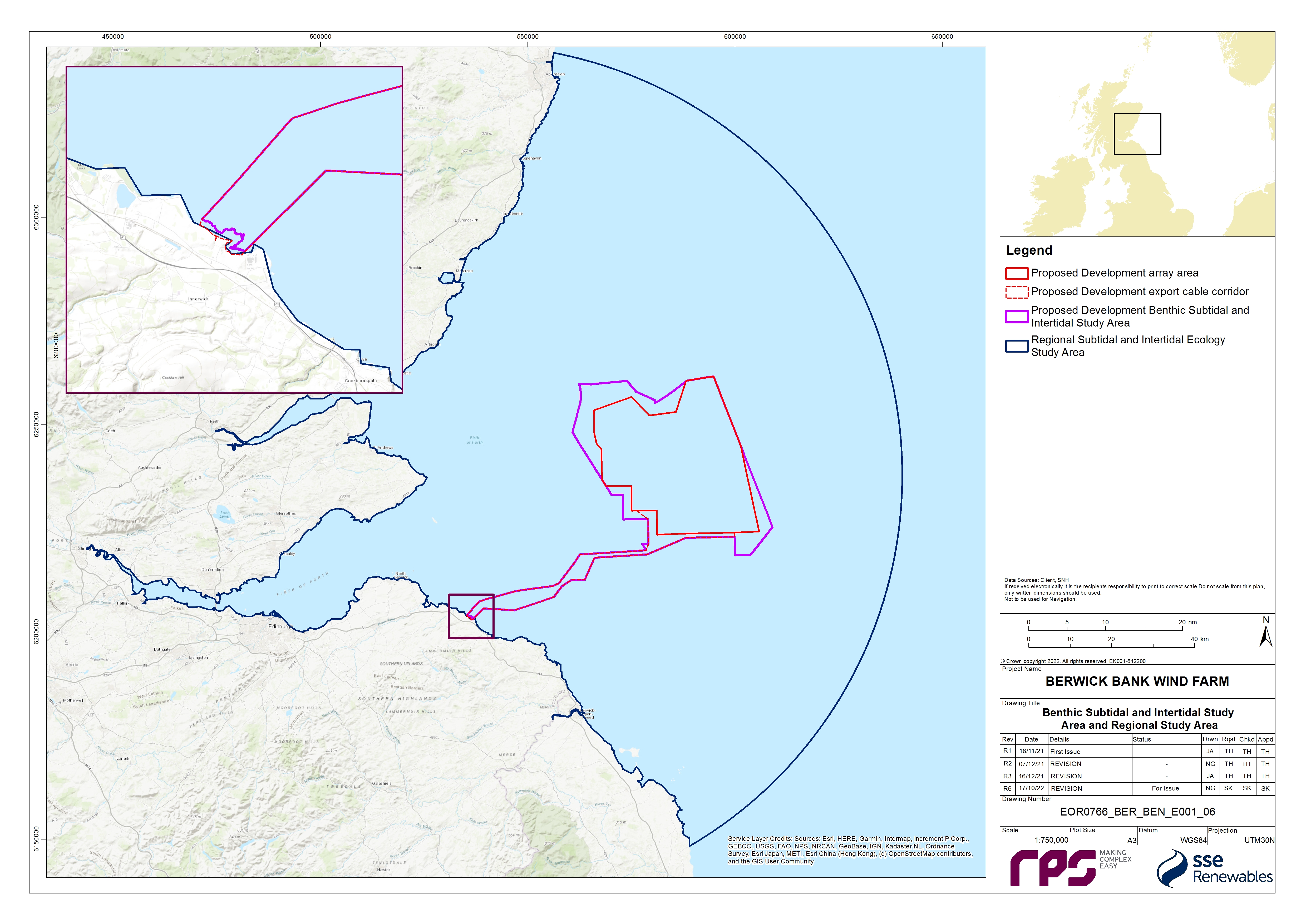
- The benthic subtidal and intertidal ecology study area has been defined as the area encompassing the Proposed Development array area, the Proposed Development export cable corridor (including intertidal habitats up to MHWS) and associated landfall. This is the area within which the site-specific benthic subtidal and intertidal surveys were undertaken ( Figure 8.1 Open ▸ ). The benthic subtidal and intertidal ecology study area extends to encompass a large area at the shore as two landfall sites were originally investigated, and one was subsequently removed from consideration. It should be noted that the spatial extent of the site-specific benthic subtidal surveys included some areas which, due to refinements to the boundary of the Proposed Development, extend beyond the boundary of Proposed Development benthic subtidal and intertidal ecology study area shown in Figure 8.1 Open ▸ . This resulted in some sampling of areas to the north-west, south-west and south-east of the Proposed Development array area, and also inshore areas to the south of the Proposed Development export cable corridor. The data collected from these areas were analysed and included in the baseline characterisation as they provide further context to the data collected within the Proposed Development benthic subtidal and intertidal ecology study area.
- The regional benthic subtidal and intertidal ecology study area encompasses the wider northern North Sea habitats and includes the neighbouring consented offshore wind farms and designated sites. It has been characterised by desktop data and has been used to provide a wider context to the site-specific data.
- Both study areas were discussed and agreed with the statutory consultees ( Table 8.5 Open ▸ ) as part of the Road Map process (see volume 3, appendix 8.2), and the regional benthic subtidal and intertidal ecology study area was reduced in size from a larger area which covered a wider section of the North Sea, on advice from Marine Scotland Science and NatureScot.
- The offshore topic of benthic subtidal and intertidal ecology study includes the intertidal area. This intertidal area overlaps with the onshore topic of ecology and ornithology (landward of MLWS).
8.4. Policy and Legislative Context
8.4. Policy and Legislative Context
- Policy and legislation on renewable energy infrastructure is presented in volume 1, chapter 2 of the Offshore EIA Report. Policy and legislation specifically in relation to benthic subtidal and intertidal ecology, is contained in Scotland’s National Marine Plan (Scottish Government, 2015), the Sectoral Marine Plan for Offshore Wind Energy (Marine Scotland Science, 2011), the Sectoral Marine Plan for Offshore Wind Energy (Scottish Government, 2020) and the United Kingdom (UK) Marine Policy Statement. A summary of the legislative provisions relevant to benthic intertidal and subtidal ecology are provided in Table 8.1 Open ▸ , with other relevant policy provisions set out in Table 8.2 Open ▸ to Table 8.4 Open ▸ .
Table 8.1: Summary of Habitat Regulations (Conservation of Offshore Marine Habitats and Species Regulations 2017, Conservation (Natural Habitats, &c.) Regulations 1994 and Conservation of Habitats and Species Regulations 2017). Relevant to Benthic Subtidal and Intertidal Ecology
Table 8.2: Summary of the Scottish National Marine Plan Relevant to Benthic Subtidal and Intertidal Ecology
Table 8.4: Summary of the UK Marine Policy Statement Relevant to Benthic Subtidal and Intertidal Ecology
8.5. Consultation
8.5. Consultation
- The Benthic Subtidal and Intertidal Ecology Road Map was a ‘live’ document which has been used as a tool to facilitate early engagement with stakeholders and subsequent engagement throughout the pre-application phase of the Proposed Development including reaching points of agreement on scoping impacts out of the assessment, and/or agreeing the level of assessment which will be presented for impacts, so that the focus in the Offshore EIA Report submission documents is on likely significant environmental effects as defined by the EIA Regulations.
- The Benthic Ecology, Fish and Shellfish Ecology and Physical Processes Road Map (up to date at the point of Application) is presented as volume 3, appendix 8.2 and documents meetings and discussion points. At the request of Marine Scotland – Licensing Operations Team (MS-LOT)[1], an Audit Document for Post-Scoping Discussions (volume 3, appendix 5.1) has been produced to document discussions on key issues, post-receipt of the Berwick Bank Wind Farm Scoping Opinion (MS-LOT, 2022).
- A summary of the key issues raised during consultation activities undertaken to date specific to benthic subtidal and intertidal ecology is presented in Table 8.5 Open ▸ , together with how these issues have been considered in the production of this Benthic Subtidal and Intertidal Ecology Offshore EIA Report chapter. Further detail is presented within volume 1, chapter 5.
Table 8.5: Summary of Key Consultation of Relevance to Benthic Subtidal and Intertidal Ecology
8.6. Methodology to Inform Baseline
8.6. Methodology to Inform Baseline
8.6.1. Desktop Study
- Information on benthic subtidal and intertidal ecology within the regional benthic subtidal and intertidal ecology study area was collected through a detailed desktop review of existing studies and datasets. These are summarised in Table 8.6 Open ▸ .
Table 8.6: Summary of Key Desktop Reports
8.6.2. Designated Sites
- All designated sites and qualifying interest features that could be affected by the construction, operation and maintenance, and decommissioning phases of the Proposed Development were identified using the three-step process as described here:
- Step 1: All designated sites of international, national, and local importance within the regional benthic subtidal and intertidal ecology study area were identified using a number of sources. These sources included the JNCC MPA mapper, and the Marine Scotland Science NMPI maps.
- Step 2: Information was compiled on the relevant IEFs for each of these sites.
- Step 3: Using the above information and expert judgement, sites were included for further consideration if:
– a designated site directly overlaps with the Proposed Development array area and the Proposed Development export cable corridor; and/or
– sites and associated features were located within the potential Zone of Influence (ZoI) for impacts associated with the Proposed Development.
- The ZoI was defined through modelling undertaken in volume 3, appendix 7.1. The ZoI identified designated sites within one tidal excursion (12 km) of the Proposed Development array area and Proposed Development export cable corridor and are therefore at the maximum range of the impacts of the Proposed Development.
8.6.3. Site-Specific Surveys
- To inform the Benthic Subtidal and Intertidal Ecology Offshore EIA Report chapter, site-specific surveys were undertaken, as agreed with the NatureScot, MS-LOT and MSS (see volume 3, appendix 8.1 for further details). A summary of the surveys undertaken to inform the benthic subtidal and intertidal ecology assessment of effects are outlined in Table 8.7 Open ▸ .
Table 8.7: Summary of Site-Specific Survey Data
8.7. Baseline Environment
8.7. Baseline Environment
8.7.1. Overview of Baseline Environment
Seabed sediments
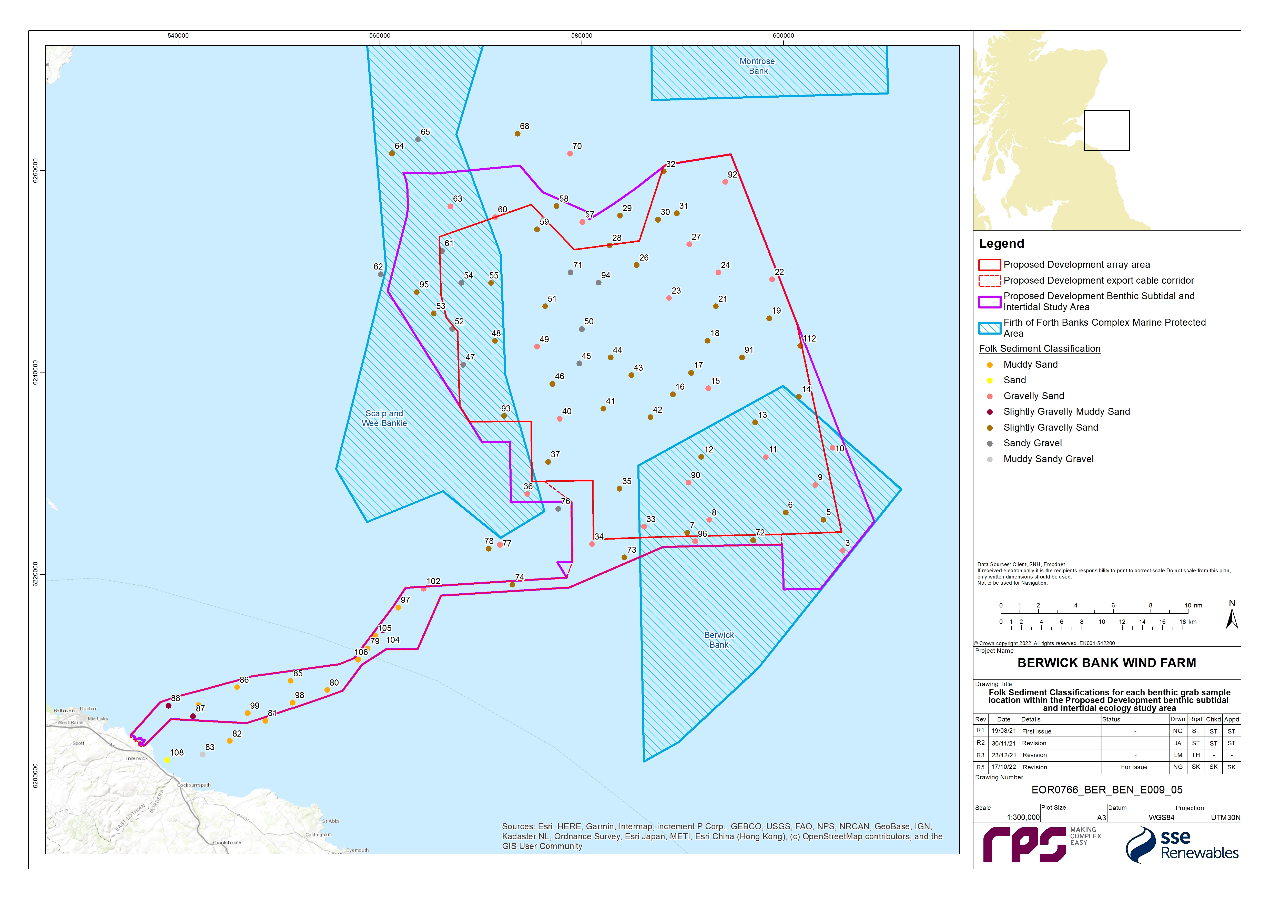
- The subtidal sediments recorded across the benthic subtidal and intertidal ecology study area range from sandy gravel to muddy sand with most samples taken during the site-specific benthic surveys classified as slightly gravelly sand ( Figure 8.2 Open ▸ ). The geophysical survey recorded extensive boulder fields across the broad topographic highs and the banks. This geophysical data also showed that the majority of the seabed is ‘featureless’, however the southern and north-western extent of the Proposed Development array area is dominated by megaripples, sand waves, ribbons and bars.
- The sediments within the eastern parts of the Proposed Development array area are dominated by slightly gravelly sands with areas of gravelly sand in the north and south. The site-specific survey data showed that the sediments within the eastern part of the Proposed Development array area are characterised by slightly gravelly sand with areas of gravelly sand in the north and south ( Figure 8.2 Open ▸ ). The sediments within the western part of the Proposed Development array area are typically slightly coarser and characterised by sandy gravel sediments in addition to slightly gravelly sand and gravelly sand ( Figure 8.2 Open ▸ ). Generally, sand makes up the highest proportion of the sediment composition, with the exception of a few samples within the western section of the Proposed Development array area which are dominated by gravel, some of which overlap with the Berwick Bank morphological features. This is aligned with the site-specific surveys’ seabed sediment results. Sediments from within the FFBC MPA are generally representative of the sediments recorded across the benthic subtidal and intertidal ecology study area.
- The sediments within the offshore section of the Proposed Development export cable corridor are characterised by muddy sand sediments which grade into slightly gravelly muddy sand, and rocky habitats with increasing proximity to the landfall ( Figure 8.2 Open ▸ ). The sample stations with the highest percentage composition of mud are generally found along the inshore section of the Proposed Development export cable corridor.
- The Skateraw landfall (which forms part of the Proposed Development) is characterised by a rock platform which is predominantly covered by sediments. A sandy bay is present at Skateraw beach which is mainly composed of fine and medium grained sand which becomes muddier at the lower shore. Larger mobile sediments (pebbles, cobbles and boulders) cover the rest of the rock platform with exposed areas of bedrock occurring in places. Additionally, some areas of bedrock contain a mosaic of deep pools cut into the sedentary platform by wave action. Rockpools frequently occur in this rocky zone. Cobbles and boulders dominate the mid to lower shore with fucoid seaweeds. Kelp beds are present in the lower shore, either attached to boulders or direct to bedrock. Pebbles and cobbles are present throughout the rocky areas of the landfall forming the beach head in the northern section of the landfall.
Sediment contamination
- Nine sediment samples from across the Proposed Development benthic subtidal and intertidal ecology study area were analysed for sediment chemistry. This analysis evaluated levels of heavy metals, organotin (dibutyltin and tributyltin), polychlorinated biphenyls, and polycyclic aromatic hydrocarbons which were then compared to the Marine Scotland Science chemical guideline Action Level 1 (AL1)/Action Level 2 (AL2) and the Canadian Sediment Quality Guidelines (CSQG; CCME, 2001). No contaminants were found to exceed AL1/AL2 or the Canadian Probable Effect Level (PEL). Only arsenic at five sample stations within the north-west of the Proposed Development array area exceeded the Canadian Threshold Effect Level (TEL).
Subtidal biotopes and habitats
- Across the benthic subtidal and intertidal ecology study area, the infaunal communities are generally dominated by annelids, molluscs and crustaceans. The most abundant individuals generally belong to Mollusca and Annelida although the tunicate Dendrodoa grossularia is overall the most abundant species. The biomass data does not reflect the dominance of Annelida with respect to the number of individuals and number of taxa, with Annelida providing the highest proportion of the biomass at only 18% of sample stations. Mollusca contribute the highest proportion of biomass at the greatest number of sample stations (45%).
- The epifaunal communities recorded by the seabed imagery are dependent on the type of sediment. In general, high numbers of epifaunal species were recorded in association with the coarser sediments. The epifaunal species recorded were dominated by crustaceans and cnidarians with low numbers of molluscs and polychaetes, however this may be due to the nature of video sampling, as most polychaetes are infaunal species therefore would not be visible to DDV sampling. Samples with coarse and mixed sediments were found associated with the presence of dead man’s fingers Alcyonium digitatum, acorn barnacles common rock barnacle Semibalanus balanoides, common starfish Asterias rubens and the polychaete Spirobranchus species.
- The epibenthic trawl analysis showed a total of 69 taxa were recorded from the 15 epibenthic trawls undertaken across the Proposed Development benthic subtidal and intertidal ecology study area. The epibenthic trawl communities were found to be generally dominated by Crustacea which contributed 73.87% to the total number of individuals and 40.42% of the total taxa. Within the Crustacea taxa the most abundant individual was brown shrimp Crangon crangon.
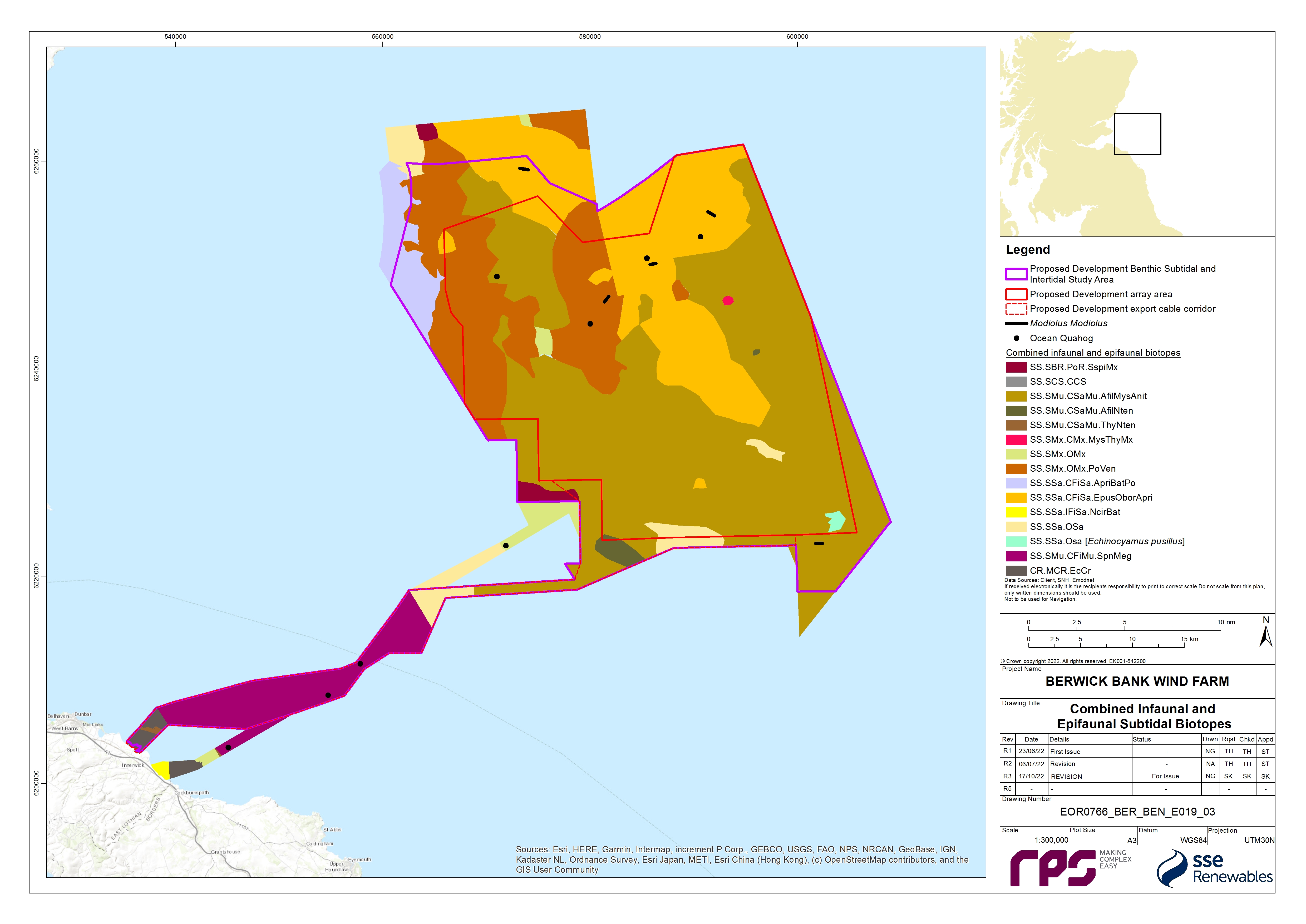
- The distribution of combined infaunal and epifaunal biotopes is presented in Figure 8.3 Open ▸ . The eastern section of the Proposed Development array area is characterised by Amphiura filiformis, Mysella bidentata and Abra nitida in circalittoral sandy mud (SS.SMu.CSaMu.AfilMysAnit) and Echinocyamus pusillus, Ophelia borealis and Abra prismatica in circalittoral fine sand (SS.SSa.CFiSa.Epus.OborApri) biotopes. There is also a small area of circalittoral sand with pea urchin (SS.SSa.OSa [Echinocyamus pusillus]) biotope in the south east and small area of Mysella bidentata and Thyasira spp. in circalittoral muddy mixed sediment (SS.SMx.CMx.MysThyMx) in the east of the Proposed Development array area. The western section of the Proposed Development array area is characterised by the polychaete-rich deep Venus community in offshore mixed sediments (SS.SMx.OMx.PoVen), and SS.SMu.CSaMu.AfilMysAnit. Just beyond the north-western boundary of the Proposed Development benthic subtidal and intertidal ecology study area the communities are characterised by the Abra prismatica, Bathyporeia elegans and polychaetes in circalittoral fine sand (SS.SSa.CFiSa.ApriBatPo) biotope. The Proposed Development export cable corridor is characterised by the SS.SMu.CSaMu.AfilMysAnit biotope in proximity to the boundary of the Proposed Development array area and by the seapens and burrowing megafauna in circalittoral fine mud (SS.SMu.CFiMu.SpnMeg) biotope in the central section. Mixed sediments and the echinoderms and crustose communities (CR.MCR.EcCr) biotope on rock were recorded in the inshore areas adjacent to the landfall.
Intertidal biotopes and habitats
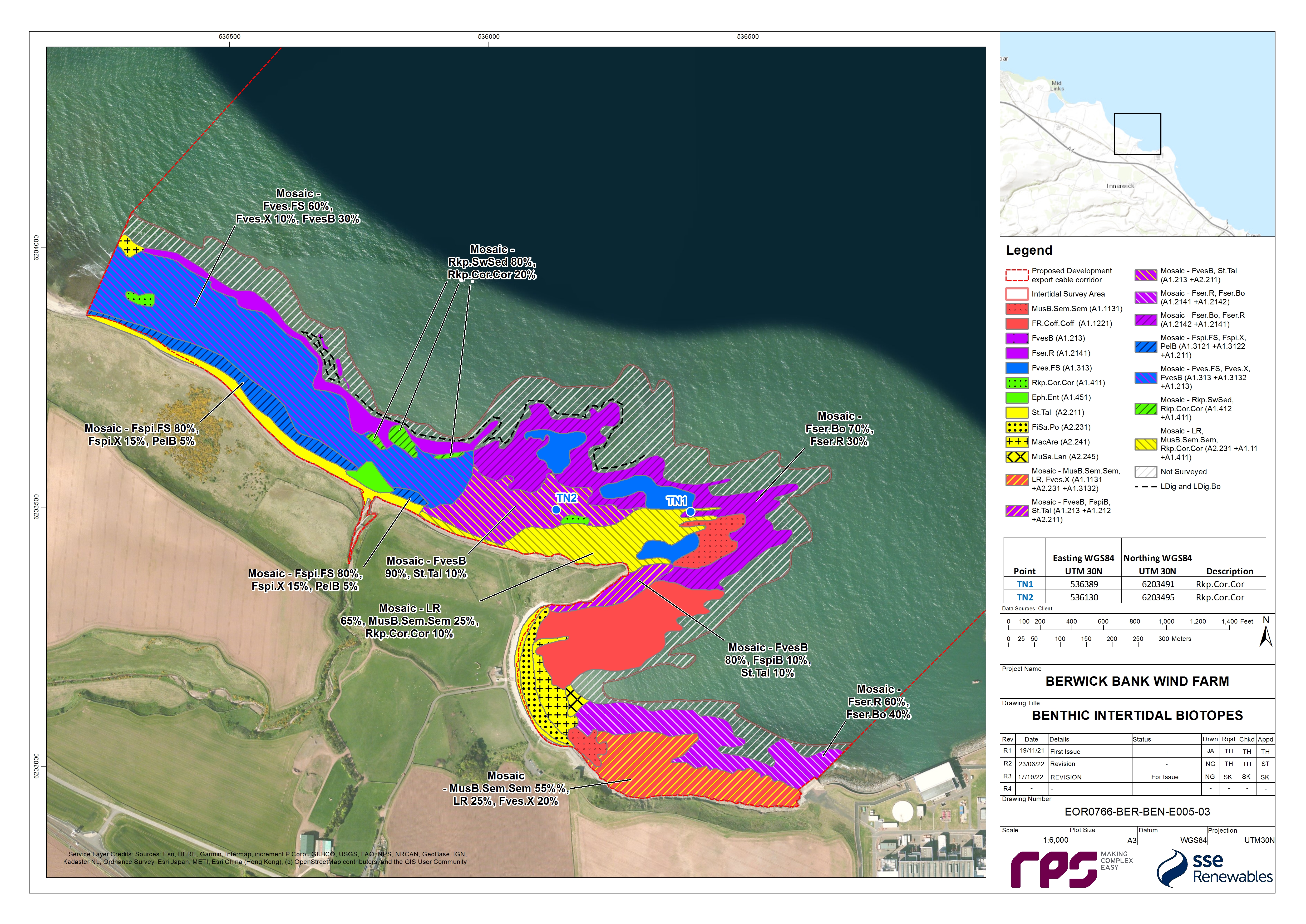
- The distribution of biotopes at the Skateraw landfall site is displayed in Figure 8.4 Open ▸ . The drift line though fairly sparse is characterised by super abundant talitrid amphipods representing the biotope talitrids on the upper shore and strand-line (LS.Lsa.St.Tal). The biotope yellow and grey lichens on supralittoral rock (LR.FLR.Lic.YG) occurs sparsely. Verrucaria maura tar lichen on littoral rock fringe (LR.FLR.Lic.Ver) occurs on upper shore bedrock, boulders and cobbles.
- The mid shore of the Skateraw landfall contains a patchwork of related biotopes, most of which are dominated by fucoids. The biotope Semibalanus balanoides, Patella vulgata and Littorina spp. on exposed to moderately exposed or sheltered vertical eulittoral rock (LR.HLR.MusB.Sem.Sem) occurs on bedrock and boulders and hosted a variety of fauna. The biotope Fucus vesiculosus and barnacle mosaics on moderately exposed mid eulittoral rock (LR.MLR.BF.FvesB) occurs predominantly on mixed rocky sediments dominated by boulders and also on bedrock. The biotope Corallina officinalis and Mastocarpus stellatus on exposed to moderately exposed lower eulittoral rock (LR.HLR.FR.Coff.Coff) is dominated by coral weed C. officinalis and coralline crusts with abundant bladder wrack F. vesiculosus. Numerous examples of the biotope coral weed and coralline crusts in shallow eulittoral rockpools (LR.FLR.Rkp.Cor.Cor) occur from the middle of the shore up to the F. spiralis zone.
- The biotope Fucus serratus on moderately exposed lower eulittoral rock (LR.MLR.BF.Fser) occurs commonly on the lower shore of the Skateraw landfall. Areas of the biotope F. serratus and under-boulder fauna on exposed to moderately exposed lower eulittoral boulders (LR.MLR.BF.Fser.Bo) and Laminaria digitata and under-boulder fauna on sublittoral fringe boulders (LR.MIR.KR.Ldig.Bo) are highly species rich with super abundant toothed wrack F. serratus and occasionally bladder wrack. Toothed wrack and the kelp L. digitata dominate the deeper waters of fucoids and kelp in deep eulittoral rockpools (LR.FLR.Rkp.FK) while coral weed and coralline crusts dominate the shallow fringes. Rockpools are predominantly characterised by the seaweeds in sediment-floored eulittoral rockpools (LR.FLR.Rkp.SwSed) biotope and large pools even contain patches of Macoma balthica and Arenicola marina in littoral muddy sand (LS.LSa.MuSa.MacAre) biotope complete with an anoxic layer.
- The biotope Macoma balthica and A. marina in littoral muddy sand (LS.LSa.MuSa.MacAre) occurs in upper shore and mid shore areas within the sandy bay at Skateraw beach. Where dense populations of sand mason worm Lanice conchilega occur and lugworm is less abundant, if present, the biotope L. conchilega in littoral sand (LS.LSa.MuSa.Lan) has been ascribed.
- In the intertidal zone at the Skateraw landfall site there are a number of habitats of conservation importance which are protected under the Conservation (Natural Habitats, &c.) Regulations 1994. These include biotopes found on sand and mudflats (e.g. LS.Lsa.St.Tal, and LS.LSa.MuSa.MacAre). Furthermore, the biotopes LR.MLR.BF.Fser.Bo and IR.MIR.KR.Ldig.Bo found in intertidal boulder communities are habitats that are listed on the Scottish Biodiversity List.
Habitat assessments
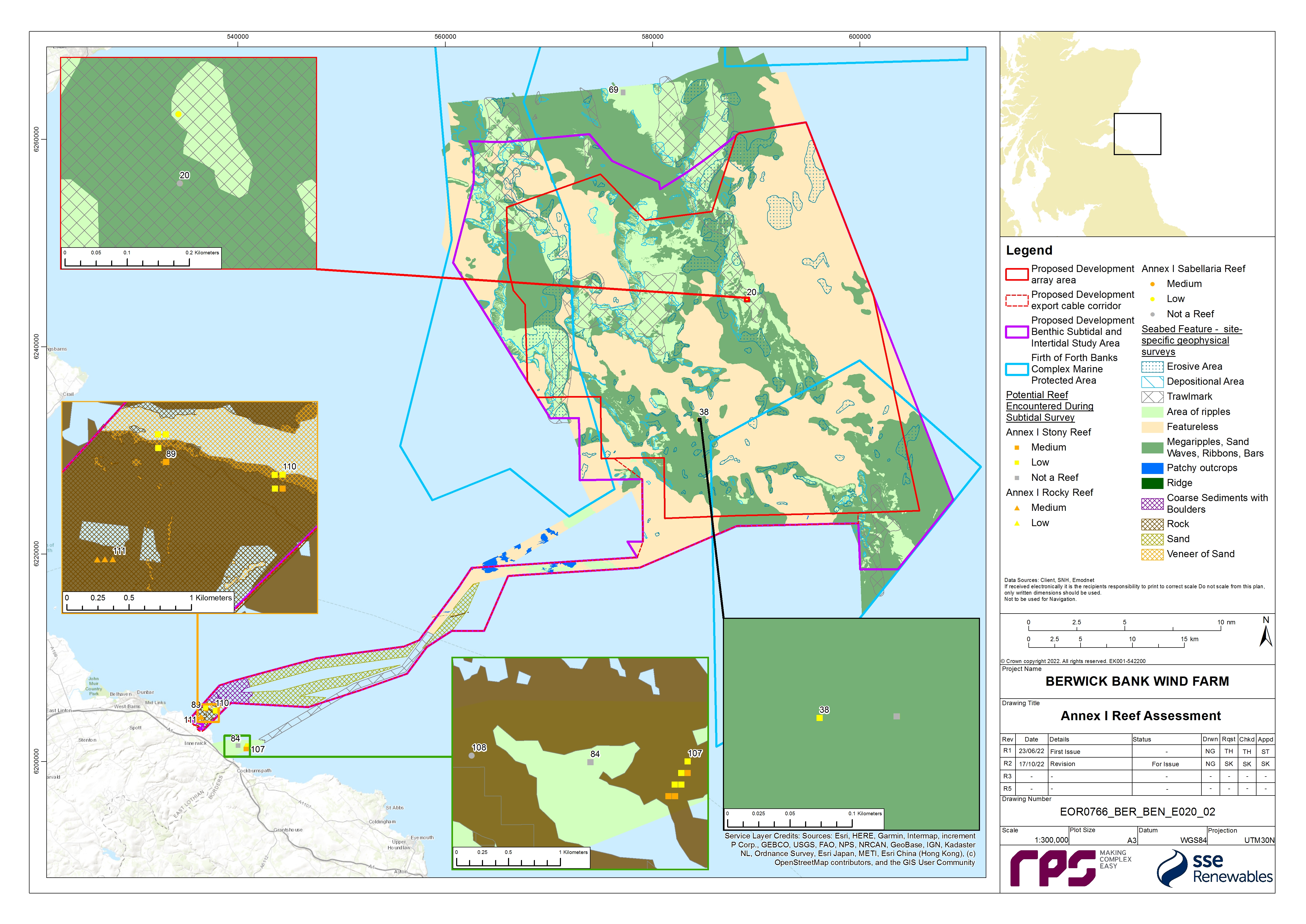
- Several seabed habitats were taken forward for further assessment to determine their potential to align with features of conservation habitats. A cobble/stony reef assessment was performed at 11 sites. These sites were found in the eastern and north-west regions of the Proposed Development array area, and in the nearshore section of the Proposed Development export cable corridor ( Figure 8.5 Open ▸ ). All the sample stations in the Proposed Development array area were classified as ‘not a reef’ or low reefiness as they all had an extent of <25 m2 and/or composition of <25% (Irving, 2009 and Jenkins et al., 2015). Therefore, it is unlikely that this would be considered Annex I cobble/stony reef habitat. Two of the stations in the Proposed Development export cable corridor, within 3 km of the Skateraw landfall, were assessed to be medium potential reef and therefore are considered to be Annex I cobble/stony reef habitat.
- One sample station in the nearshore area of the Proposed Development export cable corridor was classified as medium potential Annex I rocky reef ( Figure 8.5 Open ▸ ). The desktop data reported discrete areas of rock distributed throughout the inshore regions of the Proposed Development export cable corridor (Inch Cape Offshore Limited, 2011; EMODnet, 2019).
- A S. spinulosa reef assessment was required at three sites. These habitats were identified from the DDV and seabed imagery. The reef assessment classified two sites (ST04 and ST56) as ‘not a reef’; these areas cannot therefore be considered Annex I S. spinulosa reef habitat. A single site in the centre of the Proposed Development array area (ST20) was assigned a low reefiness score (Jenkins et al., 2015 and Gubbay, 2007) ( Figure 8.5 Open ▸ ).
- A seapen and burrowing megafauna community’s assessment was conducted on the DDV sample stations where the seapen and burrowing megafauna biotope was indicated ( Figure 8.3 Open ▸ ). Burrows were observed at 14 sample stations within the seabed stills and DDV footage. Seapens were observed at 11 of these stations but there was no indication of megafauna being present as all the burrows in the images were small in size (<1 cm). For most of the sample stations where burrows were present in the DDV footage, burrow density was classified as ‘common’ according to the SACFOR[2] scale. In accordance with the JNCC (2014) guidance, they were classified as a prominent feature of the site (frequent on the SACFOR scale is required for burrows to be classified as a prominent feature). It was therefore concluded that the 14 stations within the mid-section of the Proposed Development export cable corridor qualify as the ‘seapen and burrowing megafauna communities’ OSPAR habitat.
Species of conservation importance
- Ocean quahog were recorded in the benthic infaunal grab survey and the epibenthic trawls. The FFBC MPA is designated for ocean quahog aggregations and this species is listed on the OSPAR list of threatened and/or declining species and habitats (OSPAR, 2008). In addition, ocean quahog is a species listed as a Scottish PMF (Tyler-Walters et al., 2016). Ocean quahog individuals were recorded in eight grab samples across the Proposed Development array area and the Proposed Development export cable corridor (as shown in Figure 8.3 Open ▸ ), as well as in two epibenthic trawls in, and around, the Proposed Development array area. Most individuals recorded were juveniles (less than one year old) however four were mature specimens (estimated to be 192, 16, 166 and 193 years old). These four ocean quahog were recorded from the northern and central sections of the Proposed Development array area. One juvenile ocean quahog was recorded within the FFBC MPA.
- Horse mussel Modiolus modiolus individuals were recorded in five of the epibenthic trawls mostly at low densities except at one station in the centre of the benthic subtidal and intertidal ecology study area where 31 individuals where recorded. No M. modiolus beds were recorded during the DDV survey and no M. modiolus was recorded in the infaunal grab survey. M. modiolus were recorded in several of the benthic trawls and therefore the full extent of the benthic trawls is presented in Figure 8.3 Open ▸ as the exact location of the M. modiolus is unknown.

8.7.2. Designated Sites
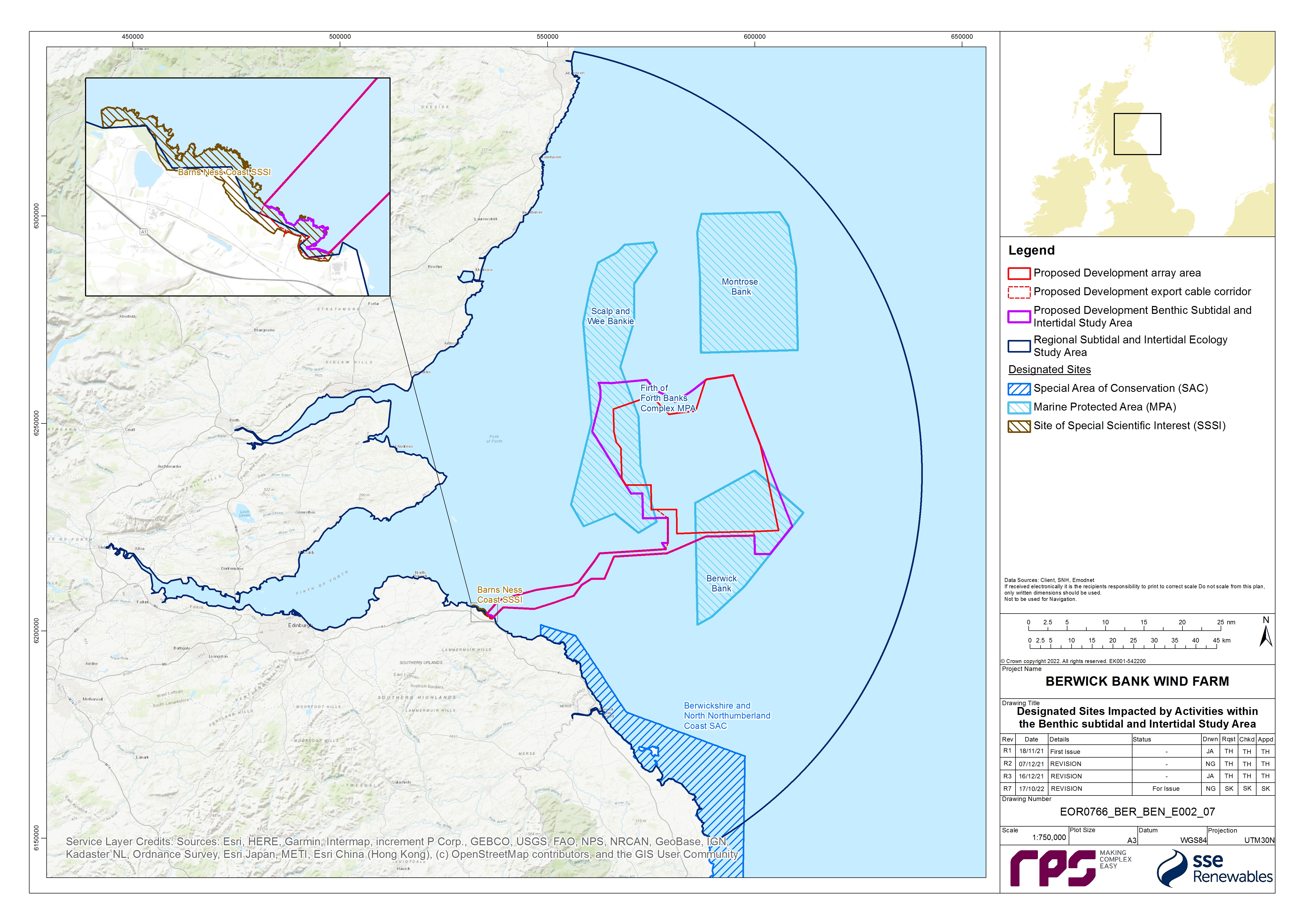
- Designated sites identified for the Benthic Subtidal and Intertidal Ecology Offshore EIA chapter are described in Table 8.8 Open ▸ . The location of these sites can be seen in Figure 8.6 Open ▸ . These sites have been identified to be within one tidal excursion (12 km) of the Proposed Development array area and Proposed Development export cable corridor and are therefore at the maximum range of the impacts of the Proposed Development. On the basis of the advice received from NatureScot in the Berwick Bank Wind Farm Scoping Opinion (MS-LOT, 2022 (see Table 8.5 Open ▸ )), the Firth of Forth SSSI, and the Berwickshire Coast (Intertidal) SSSI were subsequently screened out on the basis of no spatial overlap. With regards to European sites, as per the Berwick Bank Wind Farm Offshore HRA Screening Report (SSER, 2021b) and the Berwick Bank Wind Farm Scoping Opinion (MS-LOT, 2022) (see Table 8.5 Open ▸ ), only the Berwickshire and North Northumberland Coast SAC has been included.
Table 8.8: Designated Sites and Relevant Qualifying Interest Features for the Benthic Subtidal and Intertidal Ecology Chapter
8.7.3. Important Ecological Features
- In accordance with the best practice guidelines (CIEEM, 2019), for the purposes of the benthic subtidal and intertidal ecology EIA, IEFs have been identified. The likely significant effects of the Proposed Development which have been scoped into the assessment (see section 8.8) have been assessed against the IEFs to determine whether or not they are significant. The IEFs assessed are those that are considered to be important and potentially affected by the Proposed Development. Importance may be assigned due to quality or extent of habitats, habitat or species rarity or the extent to which they are threatened (CIEEM, 2019). Species and habitats are considered IEFs if they have a specific biodiversity importance recognised through international or national legislation or through local, regional, or national conservation plans (e.g. Annex I habitats under the Habitats Directive, OSPAR, National Biodiversity Plan or the Marine Strategy Framework Directive, Scottish PMFs and the Scottish Biodiversity list).
- All of the IEFs within the Proposed Development benthic subtidal and intertidal ecology study area are listed in Table 8.9 Open ▸ . The main habitats identified throughout the Proposed Development benthic subtidal and intertidal ecology study area comprise seven broad subtidal IEFs and three broad intertidal IEFs. The IEFs that comprise features of MPAs have also been assessed.
Table 8.9: IEFs within the Project Development Benthic Subtidal and Intertidal Ecology Study Area
8.7.4. Future Baseline Scenario
- The EIA Regulations ((The Electricity Works (Environmental Impact Assessment) (Scotland) Regulations 2017, The Marine Works (Environmental Impact Assessment) (Scotland) Regulations 2017, the Marine Works (Environmental Impact Assessment) Regulations 2007 and The Town and Country Planning (Environmental Impact Assessment) (Scotland) Regulations 2017)), require that a “a description of the relevant aspects of the current state of the environment (baseline scenario) and an outline of the likely evolution thereof without development as far as natural changes from the baseline scenario can be assessed with reasonable effort, on the basis of the availability of environmental information and scientific knowledge” is included within the Offshore EIA Report.
- In the event that the Proposed Development does not come forward, an assessment of the future baseline conditions has been carried out and is described within this section.
- Further to potential change associated with existing cycles and processes, it is necessary to take account of potential effects of climate change on the marine environment. Variability and long term changes on physical influences may bring direct and indirect changes to benthic habitats and communities in the mid to long term future (Department of Energy and Climate Change (DECC), 2016). A strong base of evidence indicates that long term changes in the benthic ecology may be related to long term changes in the climate or in nutrients (DECC, 2016), with climatic process driving shifts in abundances and species composition of benthic communities (Marine Climate Change Impacts Partnership (MCCIP), 2015). Benthic communities are also predicted to be influenced by anthropogenic activities including, contamination or seabed disturbing activities such as trawling, dredging and development (Krönke, 1995). Studies of benthic ecology over the last three decades have shown that biomass has increased by at least 250% to 400%; opportunistic and short-lived species have increased; and long-living sessile animals have decreased (Krönke, 1995; Krönke, 2011). Since the end of the 1980s, the temperature of oceanic water flowing past Scotland has increased at a rate of between 0.22°C to 0.40°C per decade, with a longer-term (1990-2006) trend of around 0.04°C (Hughes et al., 2016). The effect of this temperature rise is expected to have a different impact on each benthic group altering aspects such as distribution and reproduction (Hiscock et al., 2001). As such, the baseline in the Proposed Development benthic subtidal and intertidal ecology study area described in paragraphs 18 to 37 is a 'snapshot' of the present benthic ecosystem within a gradual yet continuously changing environment. Any changes that may occur during the 35-year design life span of the Proposed Development should be considered in the context of both greater variability and sustained trends occurring on national and international scales in the marine environment.
8.7.5. Data Limitations and Assumptions
- The data sources used in this chapter are detailed in Table 8.6 Open ▸ . The desktop data used are the most up to date, publicly available information which can be obtained from the applicable data sources as cited. To ensure an up-to-date baseline characterisation, the site-specific benthic subtidal ecology survey data have been validated with site-specific geophysical surveys undertaken in 2019 and 2021 ( Table 8.7 Open ▸ ).
- There are also specific limitations with regards to the site-specific surveys. An adjustment to the boundary of the Proposed Development export cable corridor, following the completion of the site-specific benthic subtidal surveys, resulted in a small part of the mid-section of the Proposed Development export cable corridor not being sampled during the site-specific benthic surveys. Desktop data was therefore used to extrapolate the biotope map to cover the whole Proposed Development export cable corridor. Additionally, due to the presence of dense fishing gear (potting buoys) across the western and central regions of the Proposed Development array area and western region of the Proposed Development export cable corridor, three grab stations, two DDV locations and one beam trawl were relocated/re-orientated to minimise the risk of snagging, and in terms of the beam trawl to avoid a nearby wreck. Additionally, six grab stations were abandoned, after multiple attempts, because of insufficient sediment in areas of coarse or hard ground in the east of the Proposed Development array area and the Proposed Development export cable corridor. DDV however was deployed before grabs at all stations, including where grabs were not possible, to avoid potential damage to Annex I reefs which resulted in grabs not being collected at seven stations and seven added in later after soft sediment had been identified. Furthermore, two samples were left outstanding after the surveys were stepped down due to an unfavourable long term weather forecast. Overall, 92% of grab samples were completed successfully (8% of grabs unsuccessful or left outstanding) which is sufficient to characterise the benthic subtidal and intertidal ecology study area.
- Although the sampling design and collection process for the site-specific benthic subtidal ecology survey data provided robust data on the benthic communities, interpreting these data has limitations. It can be difficult to interpolate data collected from discrete sample locations to cover a wider area and define the precise extents of each biotope. Benthic communities generally show a transition from one biotope to another and therefore boundaries of where one biotope ends and the next begins is an approximation; these boundaries indicate where communities grade into one another. The classification of the community data into biotopes is a best fit allocation, as some communities do not readily fit the available descriptions in the biotope classification system. The biotope map should be used to describe the main habitats which characterised the Proposed Development array area, Proposed Development export cable corridor and landfall site. Due to the limitations described previously, the biotope map shown in Figure 8.3 Open ▸ should not be interpreted as definitive areas. However, this does provide a suitable baseline characterisation which describes the main habitats and communities within the Proposed Development array area, Proposed Development export cable corridor and landfall site for the purposes of the assessment.
8.8. Key Parameters for Assessment
8.8. Key Parameters for Assessment
8.8.1. Maximum Design Scenario
- The maximum design scenarios identified in Table 8.10 Open ▸ have been selected as those having the potential to result in the greatest effect on an identified receptor or receptor group. These scenarios have been selected from the details provided in volume 1, chapter 3 of the Offshore EIA Report. Effects of greater adverse significance are not predicted to arise should any other development scenario, based on details within the Project Design Envelope (PDE) (e.g. different infrastructure layout), to that assessed here, be taken forward in the final design scheme.
Table 8.10: Maximum Design Scenario Considered for Each Impact as Part of the Assessment of Likely Significant Effect on Benthic Subtidal and Intertidal Ecology
8.8.2. Impacts Scoped out of the Assessment
- The Benthic Subtidal and Intertidal Ecology Road Map (see volume 3, appendix 8.2), as well as the Scoping Report (see volume 3, appendix 6.1), has been used to facilitate stakeholder engagement on topics to be scoped out of the assessment.
- On the basis of the baseline environment and the project description outlined in volume 2, chapter 3 of the EIA Report, a number of impacts are proposed to be scoped out of the assessment for benthic subtidal and intertidal ecology. These have been agreed with key stakeholders through consultation as discussed in volume 1, chapter 5, apart from impacts associated with the loss of carbon sequestrated in marine sediments. Otherwise, these impacts were proposed to be scoped-out in The Berwick Bank Wind Farm Offshore Scoping Report (SSER, 2021a), a position supported by MS-LOT, MSS and NatureScot. Where discussions with consultees took place after the publication of the Berwick Bank Wind Farm Scoping Opinion (MS-LOT, 2022), these are audited in the Audit Document Post-Scoping Discussions (volume 3, appendix 5.1).
- These impacts are outlined, together with a justification for scoping them out, in Table 8.11 Open ▸ .
Table 8.11: Impacts Scoped Out of the Assessment for Benthic Subtidal and Intertidal Ecology (Tick Confirms the Impact is Scoped Out)
8.9. Methodology for Assessment of Effects
8.9. Methodology for Assessment of Effects
8.9.1. Overview
- The benthic subtidal and intertidal ecology assessment of effects has followed the methodology set out in volume 1, chapter 6 of the Offshore EIA Report. Specific to the benthic subtidal and intertidal ecology EIA, the following guidance documents have also been considered:
- Guidelines for Ecological Impact Assessment (EcIA) in the UK and Ireland. Terrestrial, Freshwater and Coastal (CIEEM, 2019);
- Guidance on Environmental Considerations for Offshore Wind Farm Development (OSPAR, 2008);
- Best methods for identifying and evaluating Sabellaria spinulosa and cobble reef (Limpenny et al., 2010);
- Defining and Managing Sabellaria spinulosa Reefs (Gubbay, 2007);
- Identification of the Main Characteristics of Stony Reef Habitats under the Habitats Directive (Irving, 2009);
- NatureScot guidance: Guidance on Survey and Monitoring in Relation to Marine Renewables Deployments in Scotland – Volume 5: Benthic Habitats (SNH, 2011); and
- Guidelines for data acquisition to support marine environmental assessments of offshore renewable energy projects (Judd, 2012).
- In addition, the benthic subtidal and intertidal ecology assessment of effects has considered the legislative framework as defined by:
- The EIA Regulations;
- The Electricity Act 1989;
- The Marine (Scotland) Act 2010; and
- The Marine and Coastal Access Act 2009.
8.9.2. Criteria for Assessment of Effects
- The process for determining the significance of effects is a two-stage process that involves defining the magnitude of the likely significant effects and the sensitivity of the receptors. This section describes the criteria applied in this chapter to assign values to the magnitude of likely significant effects and the sensitivity of the receptors. The terms used to define magnitude and sensitivity are based on those which are described in further detail in volume 1, chapter 6 of the Offshore EIA Report.
- The criteria for defining magnitude in this chapter are outlined in Table 8.12 Open ▸ . In determining magnitude within this chapter, each assessment considered the spatial extent, duration, frequency and reversibility of impact and these are outlined within the magnitude section of each assessment of effects (e.g. a duration of hours or days would be considered for most receptors to be of short term duration, which is likely to result in a low magnitude of impact).
Table 8.12: Definition of Terms Relating to the Magnitude of an Impact
- The Marine Evidence based Sensitivity Assessment (MarESA) and the FeAST have been drawn upon to support the assessment of sensitivity of the benthic subtidal and intertidal ecology IEFs within the benthic subtidal and intertidal ecology study area.
- The MarESA is a database which has been developed through the Marine Life Information Network (MarLIN) of Britain and Ireland and is maintained by the Marine Biological Association (MBA), supported by statutory organisations in the UK (e.g. Department of Agriculture, Environment and Rural Affairs (DAERA), JNCC, Natural England and NatureScot). This database comprises a detailed review of available evidence on the effects of pressures on marine species or habitats, and a subsequent scoring of sensitivity against a standard list of pressures, and their benchmark levels of effect. The evidence base presented in the MarESA is peer reviewed and represents the largest review undertaken to date on the effects of human activities and natural events on marine species and habitats. It is considered to be one of the best available sources of evidence relating to recovery of seabed species and habitats. The benchmarks for the relevant MarESA pressures which have been used to inform each assessment of effect have also been referenced under each assessment of effect in section 8.11. The process for defining sensitivity in this chapter follows that defined by the MarESA sensitivity assessment, which correlates resistance and recoverability to categorise sensitivity, as set out in Table 8.14 Open ▸ .
- FeAST allows users to investigate the sensitivity of marine features in Scotland's seas to pressures arising from human activities. This sensitivity assessment considers feature tolerance (ability to absorb or resist change or disturbance) to a pressure and its ability to recover once the pressure stops. These pressures are defined by a benchmark which describes the extent and duration of the pressure but does not consider the intensity, frequency of pressures or any cumulative impacts. The tolerance and recoverability are then compiled into a matrix which provides a final assessment of the effects. Much of the evidence presented within FeAST has been derived from sensitivity assessments originally undertaken by MarLIN and further developed by a number of Scottish organisations such as NatureScot, MSS, Scottish Environment Protection Agency (SEPA) and JNCC. The tool focusses on features of conservation interest such as protected features of MPAs and PMFs. The process for defining sensitivity in this chapter follows that defined by the FeAST sensitivity assessment, which correlates resistance and recoverability to categorise sensitivity, as set out in Table 8.13 Open ▸ .
- The FeAST is particularly focussed on features relevant to nature conservation MPAs in Scotland and is informed more generally by the MarESA. As a result FeAST doesn’t assess all the relevant IEFs in the required level of detail therefore where the sensitivity differs between the two tools, the tool with the most relevant detail will take precedent, in most scenarios this has been the MarESA.
- The sensitivities of benthic subtidal and intertidal IEFs presented within this EIA Report have therefore been defined by an assessment of the combined vulnerability (i.e. resistance, following MarESA, or tolerance following FeAST) of the receptor to a given impact and the likely rate of recoverability to pre-impact conditions (consistent with both MarESA and FeAST). Here, vulnerability is defined as the susceptibility of a species to disturbance, damage or death, from a specific external factor. Recoverability is the ability of the same species to return to a state close to that which existed before the activity or event which caused change. Recoverability is dependent on a receptor’s ability to recover or recruit subject to the extent of disturbance/damage incurred. Information on these aspects of sensitivity of the benthic subtidal and intertidal IEFs to given impacts has been informed by the best available evidence following environmental impact or experimental manipulation in the field and evidence from the offshore wind industry and analogous activities such as those associated with aggregate extraction, electrical cabling, and oil and gas industries.
Table 8.13: Definition of Terms Relating to the Sensitivity of the Receptor (Applicable to MarESA and FeAST Sensitivity Assessment)
- The conclusions of the MarESA and FeAST assessments have been combined with the importance of the relevant IEF(s) as defined in section 8.7 and as presented in Table 8.9 Open ▸ for the benthic subtidal and intertidal IEFs considered in this assessment. The overall sensitivity of a receptor to an impact (based on the combination of vulnerability and recoverability) is then defined as presented in Table 8.14 Open ▸ .
Table 8.14: Definition of Terms Relating to the Overall Sensitivity of the Receptor
- The significance of the effect upon benthic subtidal and intertidal ecology is determined by correlating the magnitude of the impact and the sensitivity of the receptor. The particular method employed for this assessment is presented in Table 8.15 Open ▸ .
- In cases where a range is suggested for the significance of effect, there remains the possibility that this may span the significance threshold (i.e. the range is given as minor to moderate). In such cases the final significance conclusion is based upon the author’s professional judgement as to which outcome delineates the most likely effect. Where professional judgement is applied to quantify final significance from a range, the assessment will set out the factors that result in the final assessment of significance. These factors may include the likelihood that an effect will occur, data certainty and relevant information about the wider environmental context.
- For the purposes of this assessment:
- A level of residual effect of moderate or more will be considered a ‘significant’ effect in terms of the EIA Regulations; and
- A level of residual effect of minor or less will be considered ‘not significant’ in terms of the EIA Regulations.
- Effects of moderate significance or above are therefore considered important in the decision-making process, whilst effects of minor significance or less warrant little, if any, weight in the decision-making process.
Table 8.15: Matrix Used for the Assessment of the Significance of the Effect
8.9.3. Designated Sites
- Where Natura 2000 sites (i.e. nature conservation sites in Europe designated under the Habitats or Birds Directives[19]) or sites in the UK that comprise the National Site Network (collectively termed ‘European sites’) are considered, this chapter makes an assessment of the likely significant effects in EIA terms on the qualifying interest feature(s) of these sites as described within section 8.7 of this chapter. The assessment of potential impacts on the site itself are deferred to the RIAA (SSER, 2022c) for the Proposed Development. A summary of the outcomes reported in the RIAA is provided in section 8.15 of this chapter.
- With respect to locally designated sites and national designations (other than European sites), where these sites fall within the boundaries of a European site and where qualifying interest features are the same, only the features of the European site have been taken forward for assessment. This is because potential impacts on the integrity and conservation status of the locally or nationally designated site are assumed to be inherent within the assessment of the features of the European site (i.e. a separate assessment for the local or national site features is not undertaken). However, where a local or nationally designated site falls outside the boundaries of a European site, but within the benthic subtidal and intertidal ecology study area, an assessment of the likely significant effects on the overall site is made in this chapter using the EIA methodology.
8.10. Measures Adopted as part of the Proposed Development
8.10. Measures Adopted as part of the Proposed Development
- As part of the project design process, a number of measures have been proposed to reduce the potential for impacts on benthic subtidal and intertidal ecology (see Table 8.16 Open ▸ ). As there is a commitment to implementing these measures, they are considered inherently part of the design of the Proposed Development) and have therefore been considered in the assessment presented in section 8.11 (i.e. the determination of magnitude and therefore significance assumes implementation of these measures). These measures are considered standard industry practice for this type of development.
Table 8.16: Designed In Measures Adopted as Part of the Proposed Development
8.11. Assessment of Significance
8.11. Assessment of Significance
- The likely significant effects arising from the construction, operation and maintenance and decommissioning phases of the Proposed Development are listed in Table 8.10 Open ▸ , along with the maximum design scenario against which each impact has been assessed.
- An assessment of the likely significance of the effects of the Proposed Development on benthic subtidal and intertidal ecological receptors caused by each identified impact is given below.
Temporary Habitat Loss/Disturbance
- Temporary habitat loss/disturbance of subtidal and intertidal habitats within the Proposed Development benthic ecology subtidal and intertidal study area will occur during construction, operation and maintenance, and decommissioning phase ( Table 8.10 Open ▸ ). Temporary habitat loss/disturbance can result from activities including use of jack-up vessels during foundation installation, sand wave and boulder clearance, cable installation and repair as well as anchor placements associated with these activities.
- The relevant MarESA and FeAST tool pressures and their benchmarks which have used to inform this assessment of effects are described here:
- Habitat structure changes - removal of substratum (extraction): the benchmark for which is the extraction of substratum to 30 cm. This pressure is considered to be analogous to the impacts associated with sand wave and boulder clearance, and the construction of exit punches out associated with trenchless techniques such as HDD.
- Abrasion/disturbance at the surface of the substratum or seabed: the benchmark for which is damage to surface features (e.g. species and physical structures within the habitat). This pressure corresponds to the impacts associated with jack-up vessel operations, anchor placements.
- Penetration and/or disturbance of the substratum subsurface: the benchmark for which is damage to sub-surface features (e.g. species and physical structures within the habitat). This pressure corresponds to the impacts associated with cable installation and jack-up vessel operations.
- Smothering and siltation rate changes (heavy): the benchmark for which is heavy deposition of up to 30 cm of fine material added to the habitat in a single discrete event. This pressure corresponds to impacts associated with the deposition of sand wave material dredged prior to cable installation.
- As discussed in paragraph 40, this assessment has been undertaken on the broad IEFs and separately on the IEFs that comprise features of the FFBC MPA, the Berwickshire and North Northumberland Coast SAC and the Barns Ness Coast SSSI.
Construction Phase
Magnitude of Impact
Subtidal Habitat IEFs
- The installation of the Proposed Development infrastructure within the Proposed Development benthic ecology subtidal and intertidal study area will lead to temporary subtidal habitat loss/disturbance. The maximum design scenario includes for up to 113,974,700 m2 of temporary subtidal habitat loss/disturbance during the construction phase ( Table 8.10 Open ▸ ). This equates to approximately 7.86% of the benthic subtidal and intertidal ecology study area.
- Seabed preparation activities throughout the construction phase (e.g. sand wave and boulder clearance) will occur in advance of the installation of inter-array cables, OSP/Offshore convertor station platform interconnector cables and offshore export cables. Of the total temporary habitat loss, up to 69,320,500 m2 is predicted to be temporarily lost/disturbed within the benthic subtidal and intertidal ecology study area due to deposition of the material dredged during pre-construction sand wave clearance. Dredged material resulting from the seabed preparation works will be disposed within the Proposed Development array area and Proposed Development export cable corridor. Pre-construction sand wave clearance activities and disposal within the Proposed Development array area and Proposed Development export cable corridor is assumed to result in sediment deposition to a uniform depth of 0.5 m. Any mounds of cleared material will, however, erode over time and displaced material will re-join the natural sedimentary environment, gradually reducing the size of the mounds.
- Temporary habitat disturbance of up to 42,948,000 m2 may occur as a result of the burial of up to 1,225 km of inter-array cables, 94 km of OSP/Offshore convertor station platform interconnector cables and up to 872 km of offshore export cables. Sand wave clearance may be required for up to 20% of Proposed Development export cable corridor length and up to 30% of inter-array cables and OSP/Offshore convertor station platform interconnector cables. Boulder clearance may be required for up to 20% of offshore export cables length, inter-array cables and OSP/Offshore convertor station platform interconnector cables ( Table 8.10 Open ▸ ). The maximum width of seabed preparation is greater than the disturbance associated with the cable installation itself (i.e. 15 m for cable burial, 25 m for boulder clearance and 25 m for sand wave clearance). Cable burial will therefore occur within the area previously disturbed via sand wave or boulder clearance resulting in localised repeat disturbance within a 15 m wide corridor, within the wider 25 m corridor disturbed during sand wave and boulder clearance.
- A recent study reviewed the effects of cable installation on subtidal sediments and habitats, drawing on monitoring reports from over 20 UK offshore wind farms (RPS, 2019). This review showed that sandy sediments (e.g. Subtidal Sand and Muddy Sand Sediment IEF and Subtidal Sands and Gravels IEF) recover quickly following cable installation, with trenches infilling quickly following cable installation and little or no evidence of disturbance in the years following cable installation. It also presented evidence that remnant cable trenches in coarse and mixed sediments (e.g. Subtidal Coarse and Mixed Sediment IEF) were conspicuous for several years after installation. However, these shallow depressions were of limited depth (i.e. tens of centimetres) relative to the surrounding seabed, over a horizontal distance of several metres and therefore did not represent a large shift from the baseline environment (RPS, 2019). Remnant trenches (and anchor drag marks) were observed years following cable installation within areas of muddy sand sediments, although these were relatively shallow features (i.e. a few tens of centimetres).
- There will be anchor footprints from installation vessels, typically one anchor reposition per 500 m of cable may be required, with individual anchors associated with cable installation vessels having a footprint of approximately 100 m2. This area of seabed disturbance will depend on the precise vessel used and in some cases anchor placements may not be required at all (e.g. where the vessel uses dynamic positioning). The maximum design scenario accounts for up to 438,200 m2 from a 100 m2 anchor placed every 500 m during inter-array, OSP/Offshore convertor station platform interconnector and offshore export cables installation.
- Jack-up footprints associated with foundation installation will result in compression of seabed sediments beneath spud cans where these are placed on the seabed. This is estimated to disturb up to 1,268,000 m2 of seabed habitat. These depressions will infill over time, although may remain on the seabed for a number of years, as demonstrated by monitoring studies of UK offshore wind farms (BOWind, 2008; EGS, 2011). Monitoring at the Barrow offshore wind farm showed depressions were almost entirely infilled 12 months after construction (BOWind, 2008). Monitoring at the Lynn and Inner Dowsing (LID) offshore wind farm also showed some infilling of the footprints, although the depressions were still visible two years post-construction (EGS, 2011). In areas where mobile sands are present, such as in the Proposed Development array area ( Figure 8.2 Open ▸ ), jack-up depressions are likely to be temporary features which will only persist for a period of months to a small number of years.
- As outlined in Table 8.10 Open ▸ , the maximum design scenario assumes the clearance of up to 14 UXOs from the Proposed Development. The preferred method of removal is for low order clearance methods (only sub sonic combustion, with a single donor charge for each clearance event). These methods allow for the explosive content of a UXO to ignite and burn out but not detonate, these methods result in an 11 times reduction in sound emissions compared to high order detonation of UXO (UK Government, 2020) as well having a localised impact on the seabed. There is a small risk that a low order clearance could result in high order detonation of UXO. In addition, some UXOs may be deemed to be too unstable to warrant a low order approach and therefore for safety reasons would need to be cleared using high order methods.
- A study undertaken for the Norfolk Vanguard offshore wind farm found the likely diameter of UXO craters for any given charge size in the marine environment following detonation would result in a maximum crater diameter of 21.11 m (Ordteck, 2018). A crater of this size would be within the footprint of sand wave/boulder clearance activities and/or foundation footprints and therefore will not lead to any additional habitat disturbance beyond what has already been considered for these activities. Any craters created during detonation are expected to gradually backfill by natural processes, the speed of which would depend on the sediment transport regimes in the area. The depth of the crater would not increase the amount of temporary habitat disturbance/loss of the characteristic communities of the Proposed Development area as the maximum design scenario assumes the clearance of sand waves with an average height of up to 5 m of sediment in the Proposed Development export cable corridor and 1.5 m in the inter-array/interconnector cable corridor, and Ordtek (2018) estimate the maximum depth of a UXO crater to be 3.30 m. This activity will not result in an increase in habitat disturbance as the infauna in the biotopes found in the Proposed Development are associated with the top 0.5 m of sediment (Tillin and Garrard, 2019; De-Bastos, 2016; De Basto and Hill, 2016; Hill, Tyler and Garrard, 2020; Tillin Marshall, Gibb and Garrard, 2020). Recovery from large scale extraction may occur over two to ten years, however, as the habitat loss due to UXO clearance is small scale, affecting discrete areas and will occur in a limited time scale, recovery is expected to be rapid (at the lower end of the scale) (McLusky et al., 1983). Paragraph 78 provides evidence of how depressions associated with jack-up footprints are likely to infill.
- In the intertidal area trenchless techniques (e.g. HDD) will be used for cable installation which will not result in any direct habitat disturbance to intertidal habitats. The effect of habitat loss on benthic intertidal receptors is therefore not considered further for this impact.
- As outlined in Table 8.10 Open ▸ , offshore export cables installation at the landfall will be via trenchless burial techniques only (e.g. HDD) and the associated exit punches out will be located between 488 m and 1,500 m from MHWS. The implication of this is that onward cable installation in the nearshore area will be through the area of nearshore subtidal rock. Temporary habitat disturbance associated with the installation of up to eight exit punches out, at least 488 m from the MHWS mark, is included within the maximum width of disturbance for cable burial including boulder and sand wave clearance (i.e. 25 m wide corridor; see Table 8.10 Open ▸ ). The onward installation of offshore export cables, including any seabed preparation works, through the nearshore subtidal rock may occur over a distance of up to 1,416 m for each cable (the distance from the exit punches out to the nearest sedimentary biotope) with a width of disturbance of 25 m (although noting that the width of disturbance associated with cable installation alone is up to 15 m). Therefore, of the 42,948,000 m2 of temporary disturbance associated with cable installation discussed in paragraph 75, up to 283,200 m2 may occur within nearshore rock. This equates to approximately 3.5% of this nearshore rock habitat within the Proposed Development export cable corridor (this was calculated based on extents taken from JNCC Annex I reef data for the UK) and an even smaller proportion of the distribution of this habitat within the regional benthic subtidal and intertidal ecology study area. This assessment of temporary habitat disturbance primarily considers the impacts associated with abrasion of this habitat during cable installation with the impact associated with the creation of the trench itself considered in the assessment of long-term habitat loss (see paragraph 274 et seq.). As outlined in Table 8.16 Open ▸ , pre-construction Annex I reef surveys will be undertaken to determine the location, extent and composition of any geogenic reefs within the Proposed Development. Should reef features be identified appropriate measures will be discussed with the statutory consultees to avoid direct impacts to these features where reasonably practicable, and on the basis of the extent of these features at the time of construction.
- Installation of the Proposed Development infrastructure, resulting in the temporary subtidal habitat loss/disturbance will occur intermittently throughout the construction period. The offshore construction phase which includes activities resulting in temporary habitat loss/disturbance will occur over a period of up to 96 months.
- The impact is predicted to be of local spatial extent, medium term duration, intermittent and high reversibility. It is predicted that the impact will affect the receptors directly. The magnitude is therefore considered to be medium.
Firth of Forth Banks Complex MPA
- The FFBC MPA overlaps with the site boundary for the Proposed Development and therefore some temporary habitat loss/disturbance may occur within the FFBC MPA. The total area of the FFBC MPA is 2,130 km2, which includes Scalp and Wee Bankie (827.1 km2 which is 39% of the total MPA), Berwick Bank (541 km2 which is 25% of the total MPA) and Montrose Bank (761.8 km2 which is 36% of the total MPA). The Montrose Bank part of the MPA does not however overlap within the Proposed Development and, therefore, will not be affected. The total overlap of the Proposed Development and the FFBC MPA equates to a total of 331.7 km2, of which 316.5 km2 is within the Proposed Development array area (31.33% of the Proposed Development array area), and 15.2 km2 in the Proposed Development export cable corridor (13.08% of the Proposed Development export cable corridor). Overall, within the total area of overlap between the MPA and Proposed Development, 30.81% occurs within Scalp and Wee Bankie and 69.19% occurs within Berwick Bank. The maximum design scenario for the FFBC MPA has therefore been calculated on the assumption that 31.33% of the infrastructure which is to be installed in the Proposed Development array area could be placed in the part of the Proposed Development array area which overlaps with the FFBC MPA. Similarly, it is assumed that 13.08% of the infrastructure which is to be installed in the Proposed Development export cable corridor could be placed in the part of the Proposed Development array area which overlaps with the FFBC MPA.
- Based on the assumptions outlined above, and the maximum design scenario, for the purposes of this assessment is it assumed that up to 24,697,566 m2 of temporary habitat loss/disturbance may occur within the FFBC MPA (see Table 8.17 Open ▸ ), which equates to 1.16% of the total area of the FFBC MPA. This can be broken down for the composite parts of the MPA as follows: up to 17,088,005 m2 within the area of Berwick Bank (3.16% of the area of Berwick Bank) and up to 7,609,561 m2 within the area of Scalp and Wee Bankie (0.92% of the area of Scalp and Wee Bankie). The Montrose Bank will not be affected by habitat loss/disturbance.
- The total area of temporary subtidal habitat loss represents a very small percentage loss (0.003%) of the total area of the OSPAR Region II (Greater North Sea) within which ocean quahog is listed as under threat and/or decline. It also represents a small percentage (1.16%) of the offshore subtidal sands and gravels feature of the MPA, which is also equivalent to the available supporting habitat for ocean quahog.
- The impact is predicted to be of local spatial extent, medium term duration, intermittent and high reversibility. It is predicted that the impact will affect the receptors directly. The magnitude is therefore considered to be low.
Table 8.17: Area of FFBC MPA Disturbed by Activities During the Proposed Development’s Construction
Berwickshire and North Northumberland Coast SAC
Barns Ness Coast SSSI
Sensitivity of the Receptor
Subtidal Habitat IEFs
- The key IEFs which are expected to be affected by temporary subtidal habitat loss/disturbance are listed in Table 8.18 Open ▸ . The sensitivity of the IEFs to temporary subtidal habitat loss are presented in Table 8.18 Open ▸ . These sensitivities are based on assessments made by the MarESA and FeAST tool. Most IEFs have low to medium sensitivity to the MarESA pressures associated with temporary subtidal habitat loss/disturbance. All IEFs have a low to medium sensitivity to the FeAST pressures associated with temporary subtidal habitat loss/disturbance based on the related pressures.
- The subtidal sand and muddy sand sediment IEF has a medium sensitivity to the pressures associated with temporary habitat loss and disturbance. Activities such as sand wave clearance would largely be undertaken in sandy sediments, with fast recovery rates following disturbance. Based on the MarESA sensitivity assessment, recovery of the sand-based habitats following habitat structure changes - removal of substratum (extraction), is likely to occur following the construction phase, aided by wave action and sand mobility (Tillin and Garrard, 2019). As the sediment type deposited to the seabed will be similar to those in surrounding areas, benthic assemblages would be expected to recolonise these areas. Penetration and/or disturbance of the substratum subsurface however is likely to cause the loss/damage of a proportion of characterising species for biotopes such as SS.SMu.CSaMu.ThyNten and SS.SMu.CSaMu.AfilMysAnit, with muddy sand habitats reported as having the longest recovery times. Abrasion/disturbance at the surface of the substratum has a similar effect however burrowing may provide some protection, damage and loss are still expected to occur. It has been reported that benthic communities associated with soft sediments (e.g. muds, sands and gravels) readily recover into areas where disturbance by cable installation has occurred if the sediment type is reflective of the baseline environment (RPS, 2019). Sandy sediments recover over relatively short timescales (e.g. months to one to two years; Newell et al., 2004) and coarse, gravelly and mixed sediments showing longer recovery timescales, usually within five years (Desprez, 2000; Newell et al., 1998; Pearce et al., 2007), but in some cases, recovery has been reported as taking up to nine years following cessation of dredging (Foden et al., 2009).
- Within the subtidal coarse and mixed sediment IEF, the biotope SS.SMx.CMx.FluHyd is the most sensitive to the pressures associated with temporary habitat loss/disturbance. This is because this biotope is characterised by epifauna such as dahlia anemone Urticina felina and A. digitatum (Connor et al., 2004) which have no resistance to habitat structure change. The resistance to penetration and/or disturbance of the substratum subsurface or abrasion/disturbance of the substratum or seabed is dependent on the duration and magnitude of the pressure. The biotope SS.SMx.OMx.PoVen is most sensitive to heavy smothering and siltation rate changes within this IEF however this is dependent on the character of the smothering (i.e. the depth, small bivalves could migrate was 20 cm in sand for Donax; approximately 40 cm in mud for Tellina sp. and approximately 50 cm in sand (Essink, 1999)), and the type of material. Individuals are more likely to escape from a covering similar to the sediments in which the species is found than a different type (Tillin, 2016).
- The seapens and burrowing megafauna IEF has a medium sensitivity to the abrasion/disturbance at the surface of the substratum or seabed but have high sensitivity to penetration and habitat structure change MarESA pressures associated with temporary subtidal habitat loss. Habitat structure changes – removal of substratum could remove most of the resident seapens present should it meet the benchmark of the removal of 30 cm of sediment (Hill et al., 2020) and similarly penetrative activities are likely to disturb or lead to mortality of seapens and burrowing megafauna in their burrows making resistance and resilience low and sensitivity high. They are however likely to recover within two years of experiencing pressures from surface abrasion.
- The Sabellaria reef outside of an SAC IEF has a medium sensitivity to all the identified pressures for temporary habitat loss/disturbance. Sabellaria spinulosa which characterises this IEF is epifaunal and therefore vulnerable to surface abrasion and heavy smothering and siltation rate changes which can damage the tubes of the worms, however their recovery from burial events is high, especially over a short period of time (Tillin et al., 2020). Penetration and/or disturbance of the substratum subsurface is likely to damage and break-up tube aggregations leading to the loss of reef within the footprint of direct impact (Tillin et al., 2020). As outlined in Table 8.16 Open ▸ , a pre-construction Annex I reef survey will be undertaken to determine the location, extent and composition of any biogenic reefs within the Proposed Development. Should such reef features be identified during pre-construction surveys, appropriate measures will be discussed with statutory consultees to avoid direct impacts to these features, where reasonably practicable, and on the basis of the extent of these features at the time of construction.
- The moderate energy subtidal rock, cobble/stony reef outside of an SAC and rocky reef outside an SAC IEFs may all be affected by offshore export cables installation in the nearshore area including exit punches out for trenchless techniques. These IEFs were all characterised by the CR.MCR.EcCr biotope during the site-specific benthic surveys and the hard nature of the substrate. The construction activities considered within this assessment of temporary habitat loss/disturbance primarily relate to those resulting in abrasion of the surface of this habitat, with the assessment of impacts associated with the construction of the trench itself considered in the long-term habitat loss assessment (see paragraph 274 et seq.). Epifaunal communities on rocky substrates, such as bryozoans, hydroids, soft corals and sponges can be damaged or removed by passing abrasion, and where they occur on mobile substrates such as cobbles the material can be moved or turned leading to further damage (Boulcott and Howell, 2011). The organisms associated with the moderate energy subtidal rock, cobble/stony reef outside of an SAC and rocky reef outside an SAC IEFs are likely to recolonise quickly following abrasion as they are characterised by rapid growth and early reproduction as well as multiple reproductive phases which would allow the biotope to recover quickly (MarLIN, 2011). Ultimately the impact of abrasion on these IEFs will depend on the magnitude and duration of the activity. As noted in paragraph 81 the area of installation within these habitats is small (283,200 m2) representing a similarly small percentage of the total extent of this habitat within the Proposed Development export cable corridor (3.5%, which was calculated based on JNCC Annex I reef data for the UK). Siltation and smothering during cable installation may affect epifaunal communities, especially sessile organisms, by blocking out light or clogging feeding apparatus, however the amount of siltation from the selected trenchless technique and cable installation is likely to be minimal and highly localised to the installation site. There may still be some temporary localised decline of species richness in these IEFs. Additionally, research on the installation of cables through cobble reef habitats has been found to have a very limited spatial footprint (10 to 20 m wide) with no effect on adjacent communities (<50 m from the installed cable) (RPS, 2019). As outlined in Table 8.16 Open ▸ ), pre-construction Annex I reef surveys will be undertaken to determine the location, extent and composition of any biogenic reefs within the Proposed Development. Should cobble/stony or rocky reef features be identified appropriate measures will be discussed with the statutory consultees to avoid direct impacts to this feature where reasonably practicable, and on the basis of the extent of these features at the time of construction.
- The subtidal sand and muddy sand sediments IEF, and the subtidal coarse and mixed sediments IEF are deemed to be of medium vulnerability, medium to low recoverability and regional value. The sensitivity of the IEFs is therefore, considered to be medium.
- The Sabellaria reef outside of an SAC IEF is deemed to be of medium vulnerability, medium recoverability, and national value. The sensitivity of the IEF is therefore, considered to be high.
- The seapens and burrowing megafauna IEF is deemed to be of high vulnerability, low recoverability and national value. The sensitivity of the IEF is therefore, considered to be high.
- The moderate energy subtidal rock, cobble/stony reef outside of an SAC and rocky reef outside an SAC IEFs are deemed to be of medium vulnerability and medium recoverability to temporary habitat disturbance (i.e. abrasion effects) and of national value. The sensitivity of the IEFs is therefore, considered to be medium.
- Although there is an impact on PMF(s), this will not create a significant impact on the national status of these features as only a small proportion of these PMFs will be affected compared to their overall national distribution and the temporary nature of the disturbance will limit the time over which disturbance will occur. Additionally, many will recover fully within a few years of the completion of construction, resulting in no change to their overall national status.
- The construction activities will result in the displacement and potential mortality of some benthic organisms throughout the Proposed Development array area and Proposed Development export cable corridor. Molluscs and crustaceans will likely provide an increased source of food for some fish and shellfish species. This effect is applicable across all phases of the Proposed Development and the consequences for fish and shellfish receptors is considered in full in volume 2 chapter 9.
Table 8.18: Sensitivity of the Benthic Subtidal IEFs to Temporary Subtidal or Intertidal Habitat Loss/Disturbance
Firth of Forth Banks Complex MPA
- The FeAST determines that the subtidal sands and gravels IEF has a high sensitivity to surface abrasion and habitat structure change, as well as a medium sensitivity to subsurface penetration and heavy smothering and siltation rate change ( Table 8.19 Open ▸ ). Although for all pressures, the FeAST tool states that this can be reduced to low depending on the species present. The MarESA which assessed the individual biotopes of the IEFs, determines that the subtidal sands and gravels IEF, which occurs within the FFBC MPA, has a medium to low sensitivity to the pressures associated with temporary habitat loss/disturbance ( Table 8.19 Open ▸ ). The biotope SS.SSa.CFiSa.ApriBatPo has a medium sensitivity to this pressure because most of the organisms that occur in this biotope are shallow buried and sediment extraction would remove the assemblage (Tillin, 2016). This range in sensitivity based on the species present is the same for the other pressures. The MarESA assessment for surface abrasion and subsurface penetration gives a sensitivity of low for the relevant biotopes as damage may occur but recovery or high tolerance are likely. Heavy smothering and siltation rate change is assessed by the MarESA to result in a medium sensitivity by this IEF as recovery is dependent on the burrowing capacity of some species. The impact of the Proposed Development on the designated features of the FFBC MPA are also fully considered in the MPA Assessment Report (SSER, 2022b).
- The shelf banks and mounds IEF has the same sensitivity as the subtidal sands and gravel IEF outlined above as it contains the same biotopes (see Table 8.19 Open ▸ ).
- Ocean quahog IEF, a designated feature of the FFBC MPA, has high sensitivity to the abrasion, penetration, and habitat structure change MarESA pressures associated with temporary subtidal habitat loss/disturbance but are not sensitive to smothering ( Table 8.19 Open ▸ ). Similarly, to seapens, the extraction of sediment to 30 cm (the benchmark) could remove any ocean quahog present (Tyler-Walters and Sabatini, 2017). Ocean quahog are known to be vulnerable to physical abrasion, but damage is related to their body size. Thorarinsdottir and Jacobson (2005) and Thorarinsdottir et al. (2010) noted that ocean quahog was vulnerable to overfishing due to its long lifespan, slow growth, uncertain recruitment, low productivity, and poor estimates of stock biomass and capture efficiency. Studies based on trawl fishing have shown larger specimens were more affected than smaller specimens (Klein and Witbaard, 1993). This damage can increase the mortality of ocean quahog either through the damage itself, increased vulnerability to predation or high intensity pressures such as the use of hydraulic dredges (Thorarinsdottir et al., 2009). Recovery of ocean quahog populations is also dependant on the age of sexual maturity at which population expansion can begin. Ocean quahogs reach sexual maturity at between 5 and 11 years and may be dependent upon growth rate and locality (Thorarinsdóttir, 1999). Currently within the FFBC MPA demersal trawling is highest in Wee Bankie, which during 2016 recorded a total of over 2,500 hours of dredge fishing, a practice which is known to damage ocean quahogs (JNCC, 2018). These impacts are also attributed to the effect of penetration and disturbance of the substratum as ocean quahog live at the surface of the sediment while feeding but burrows to depths of 14 cm periodically (Strahl et al., 2011) where penetrative activities could damage or lead to mortalities. The recovery of ocean quahog to this kind of disturbance is slow, and a full recovery from activities such as dredge fishing which penetrate the seabed may take decades (Ragnarsson et al., 2015). Heavy smothering or siltation rate change is likely to result negligible effects to ocean quahog as they are able to burrow back to the surface. A study by Powilleit et al. (2006) deposited a till and sand/till mixture up to 1.5 m deep on to existing sediment and found the resident ocean quahogs were ‘almost’ unaffected and the population structure was similar two years later. After initial deposition, 78% and 26% reached the surface under the ‘till’ and ‘sand/till’ mixtures respectively. Finally, the removal of substratum to a depth of 30 cm will remove the substratum occupied by ocean quahog together with any other species in the assemblage (Tyler-Walters and Sabatini, 2017).
- It is worth noting that the presence of the infrastructure associated with the Proposed Development may also have some effects on ocean quahog which could facilitate the recovery following disturbance. Whilst there will be no safety zones enforced during the operation and maintenance phase (except during major maintenance events), a 50 m safe passing distance for logistical and safety reasons (i.e. to account for the offset/drifting of fishing gear that happens as a result of the tide) can be assumed for fishing vessels in the vicinity of wind turbines. The effect of this may be that trawling activity may potentially be reduced within the Proposed Development array area. As a result, ocean quahog within the area covered by these safe passing distances will potentially experience a reduced level of disturbance from commercial fishing in the long term (i.e. over the operational lifetime of the Proposed Development and potentially beyond), which may aid with the recovery of the wider population to the impact of temporary habitat disturbance/loss.
- The subtidal sands and gravel, and shelf banks and mounds IEFs are deemed to be of medium vulnerability, medium recoverability and national value. The sensitivity of the IEF is therefore, considered to be medium.
- The ocean quahog IEF is deemed to be of high vulnerability, low recoverability and national value. The sensitivity of the IEF is therefore, considered to be high.
Table 8.19: Sensitivity of the Benthic Subtidal IEFs found within the FFBC MPA to Temporary Subtidal Habitat Loss/Disturbance
Significance of the Effect
Subtidal Habitat IEFs
- For the subtidal sand and muddy sand sediments IEF, subtidal coarse and mixed sediments IEF, the moderate energy subtidal rock IEF, cobble/stony reef outside of an SAC IEF and rocky reef outside an SAC IEF the magnitude of the impact is deemed to be medium and the sensitivity of the receptor is considered to be medium. The effect will, therefore, be of moderate adverse significance in the short term(i.e. within two years of completion of construction activities), with this decreasing to minor adverse significance in the medium to long term as the sediments and communities are predicted to recover. Therefore, minor effects are predicted in the long-term which are not significant in EIA terms.
- For the seapens and burrowing megafauna IEF and the Sabellaria reef outside of an SAC IEF the magnitude of the impact is deemed to be medium and the sensitivity of the receptor is considered to be high. The effect will, therefore, be of moderate adverse significance in the short term (i.e. within two years of completion of construction), with this decreasing to minor adverse significance in the medium to long term as the sediments and communities are predicted to recover. Therefore, minor effects are predicted in the long-term which are not significant in EIA terms.
Firth of Forth Banks Complex MPA
- Overall, for the subtidal sands and gravels IEF and the shelf banks and mounds IEF, the magnitude of the impact is deemed to be low and the sensitivity of the receptor is considered to be medium. The effect will, therefore, be of minor adverse significance, which is not significant in EIA terms.
- Overall, for ocean quahog IEF, the magnitude of the impact is deemed to be low and the sensitivity of the receptor is considered to be high. The effect will, therefore, be of moderate adverse significance in the medium term (i.e. within ten years of completion of construction activities), with this decreasing to minor adverse significance in the long term as the sediments and ocean quahog populations are predicted to recover. Therefore, minor effects are predicted in the long-term which are not significant in EIA terms.
Secondary Mitigation and Residual Effect
- No benthic subtidal and intertidal ecology mitigation is considered necessary for the impact of temporary habitat loss/disturbance during the construction phase because the likely effects in the absence of further mitigation (beyond the designed in measures outlined in section 8.10), in the long term, are not significant in EIA terms.
Operation and Maintenance Phase
Magnitude of Impact
Subtidal Habitat IEFs
- Operation and maintenance activities within the Proposed Development benthic ecology subtidal and intertidal study area will lead to temporary subtidal habitat loss/disturbance. The maximum design scenario is for up to 989,000 m2 of temporary habitat loss/disturbance during the operation and maintenance phase ( Table 8.10 Open ▸ ). This will result from maintenance on each of the wind turbines and substations over the operational life. The maximum design scenario assumes up to seven major component replacements for wind turbines per year, one major component replacement every ten years for OSPs/Offshore convertor station platforms, ten access ladder replacement for wind turbines and seven access ladder replacement for OSP/Offshore convertor station platform over the lifetime of the project, and as well as cable repair and reburial when necessary ( Table 8.10 Open ▸ ). This equates to a very small proportion (0.07%) of the benthic ecology subtidal and intertidal study area. It should also be noted that only a small proportion of the total temporary habitat loss/disturbance is likely to occur at any one time over the 35 year operational lifetime.
- Temporary habitat loss will occur as a result of the use of jack-up vessels during any component replacement activities (up to 245 major component replacements for wind turbines and up to seven for the OSPs/Offshore convertor station platforms, up to ten access ladder replacements for wind turbines and seven access ladder replacements for OSPs/Offshore convertor station platforms) and during any inter-array, OSP/Offshore convertor station platform interconnector, and offshore export cables repair and reburial events. The impacts of jack-up vessel activities will be similar to those identified for the construction phase above and will be restricted to the immediate area around the wind turbine foundation or cable repair sites, where the spud cans are placed on the seabed, with recovery occurring following removal of spud cans. The spatial extent of this impact is small in relation to the total benthic ecology subtidal and intertidal study area, although there is the potential for repeat disturbance to the habitats in the immediate vicinity of the foundations because of these activities. The repair and reburial of inter-array, OSP/Offshore convertor station platform interconnector and offshore export cables will also affect benthic habitats in the immediate vicinity of these operations, with effects on seabed habitats and associated benthic communities expected to be similar to the construction phase. Activities resulting in the temporary subtidal habitat loss/disturbance will occur intermittently throughout the 35 year operation and maintenance period.
- Trenchless techniques will be used for cable installation at the landfall and therefore there will be no disturbance to intertidal habitats as a result of operation and maintenance activities to the cable at the landfall. The effect of habitat loss/disturbance on benthic intertidal receptors is therefore not considered further for this impact.
- The impact is predicted to be of local spatial extent, short term duration, intermittent and high reversibility. It is predicted that the impact will affect the receptor directly. The magnitude is therefore considered to be negligible.
Firth of Forth Banks Complex MPA
- The FFBC MPA overlaps with the site boundary for the Proposed Development and therefore some temporary habitat loss/disturbance will occur within the FFBC MPA. The overall figures for the spatial overlap are outlined in paragraph 85 together with the assumptions for the overlap of infrastructure/activities with the FFBC MPA. Based on the percentage of overlap and the maximum design scenario for the operation and maintenance phase, up to 287,961 m2 of temporary habitat loss/disturbance may occur within the FFBC MPA, which equates to 0.01% of the total area of the FFBC MPA. This can be broken down for the composite parts of the MPA as follows: up to 199,237 m2 within the area of Berwick Bank (0.04% of the area of Berwick Bank) and up to 88,723 m2 within the area of Scalp and Wee Bankie (0.01% of the area of Scalp and Wee Bankie). The Montrose Bank will not be affected.
- The total area of temporary subtidal habitat loss represents a very small percentage loss (0.00003%) of the total area of the OSPAR Region II (Greater North Sea) within which ocean quahog is listed as under threat and/or decline. It also represents a very small percentage (0.01%) of the offshore subtidal sands and gravels feature of the MPA, which is also equivalent to the available supporting habitat for ocean quahog.
- The impact is predicted to be of local spatial extent, short term duration, intermittent and high reversibility. It is predicted that the impact will affect the receptors directly. The magnitude is therefore considered to be negligible.
Sensitivity of the Receptor
Subtidal Habitat IEFs
- The sensitivity of the IEFs is as described previously for the construction phase assessment in paragraphs 91 to 102 and in Table 8.18 Open ▸ .
Firth of Forth Banks Complex MPA
- The sensitivity of the IEFs found within the FFBC MPA are as described previously for the construction phase assessment in paragraphs 103 to 107 and in Table 8.19 Open ▸ .
Significance of the Effect
Subtidal Habitat IEFs
- For the subtidal sand and muddy sand sediments IEF, the subtidal coarse and mixed sediments IEF, the moderate energy subtidal rock IEF, cobble/stony reef outside of an SAC IEF and rocky reef outside an SAC IEF the magnitude of the impact is deemed to be negligible, and the sensitivity of the receptor is considered to be medium. The effect will, therefore, be of negligible adverse significance, which is not significant in EIA terms, because of the small scale of the impact and the high rate of recovery for these habitats.
- For the seapens and burrowing megafauna IEF and the Sabellaria reef outside of an SAC IEF the magnitude of the impact is deemed to be negligible, and the sensitivity of the receptor is considered to be high. The effect will, therefore, be of minor adverse significance, which is not significant in EIA terms.
Firth of Forth Banks Complex MPA
- Overall, for the subtidal sands and gravels IEF and the shelf banks and mounds IEF, the magnitude of the impact is deemed to be negligible, and the sensitivity of the receptor is considered to be medium. The effect will, therefore, be of negligible adverse significance, which is not significant in EIA terms, because of the small scale of the impact and the high rate of recovery for these habitats.
- Overall, for ocean quahog IEF the magnitude of the impact is deemed to be negligible, and the sensitivity of the receptor is considered to be high. The effect will, therefore, be of minor adverse significance, which is not significant in EIA terms. This has been concluded on the basis that only a very small proportion of the habitat for this species in the south western North Sea is predicted to be affected and, furthermore, as described in section 8.7, with further detail in the Benthic Subtidal and Intertidal Ecology Technical Report (volume 3, appendix 8.1), this species was recorded is very low abundances within the site-specific surveys and predominately as juveniles.
Secondary Mitigation and Residual Effect
- No benthic subtidal and intertidal ecology mitigation is considered necessary for the impact of temporary habitat loss/disturbance during the operation and maintenance phase because the likely effects, in the absence of further mitigation (beyond the designed in measures outlined in section 8.10), are not significant in EIA terms.
Decommissioning Phase
Magnitude of Impact
Subtidal Habitat IEFs
- The nature and extent of temporary habitat loss/disturbance during decommissioning is likely to be similar or the same as that described for the same activities during the construction phase. However, it should be noted that this approach is considered precautionary as there is no statutory requirement for decommissioned cables to be removed. Therefore, cables may be left buried in place or alternatively partially removed by extracting the cables back out of the ducts. Such details will be included within the Decommissioning Programme which will be developed to minimise environmental disturbance and will be updated throughout the lifetime of the Proposed Development (see Table 8.16 Open ▸ ) to account for changing good practice.
- Decommissioning activities within the Proposed Development array area and Proposed Development export cable corridor will lead to temporary subtidal habitat loss/disturbance. The maximum design scenario is for up to 34,571,200 m2 of temporary habitat loss/disturbance during the decommissioning phase ( Table 8.10 Open ▸ ). The decommissioning activities includes jack-up vessels disturbing up to 1,268,000 m2 as well as up to 32,865,000 m2 for the decommissioning of inter-array, interconnector, and offshore export cables, and up to 438,200 m2 from anchor placements during cable removal. This equates to a small proportion (2.38%) of the benthic ecology subtidal and intertidal study area. In the event that cables are left in situ, the extent of temporary habitat disturbance would be reduced.
- The impact is predicted to be of local spatial extent, short term duration, intermittent and high reversibility. It is predicted that the impact will affect the receptor directly. The magnitude is therefore considered to be low.
Firth of Forth Banks Complex MPA
- The FFBC MPA overlaps with the site boundary for the Proposed Development and therefore some temporary habitat loss/disturbance will occur within the FFBC MPA. The overall figures for the spatial overlap are outlined in paragraph 85 together with the assumptions for the overlap of infrastructure/activities with the FFBC MPA. Based on this percentage of overlap and the maximum design scenario for the decommissioning phase, up to 8,412,661 m2 of temporary habitat loss/disturbance may occur within the FFBC MPA (see Table 8.20 Open ▸ ), which equates to 0.39% of the total area of the FFBC MPA. This can be broken down for the composite parts of the MPA as follows: up to 5,820,638 m2 within the area of Berwick Bank (1.08% of the area of Berwick Bank) and 2,592,023 m2 within the area of Scalp and Wee Bankie (0.31% of the area of Scalp and Wee Bankie). The Montrose Bank will not be affected.
- The total area of temporary subtidal habitat loss represents a very small percentage loss (0.001%) of the total area of the OSPAR Region II (Greater North Sea) within which ocean quahog is listed as under threat and/or decline. It also represents a very small percentage (0.39%) of the offshore subtidal sands and gravels feature of the MPA, which is also equivalent to the available supporting habitat for ocean quahog.
- The impact is predicted to be of local spatial extent, short term duration, intermittent and high reversibility. It is predicted that the impact will affect the receptor directly. The magnitude is therefore considered to be low.
Table 8.20: Area of FFBC MPA Disturbed by Activities During the Proposed Development’s Decommissioning
Sensitivity of the Receptor
Subtidal Habitat IEFs
- The sensitivity of the IEFs is as described previously for the construction phase assessment in paragraphs 91 to 102 and in Table 8.18 Open ▸ .
Firth of Forth Banks Complex MPA
- The sensitivity of the IEFs found within the FFBC MPA are as described previously for the construction phase assessment in paragraphs 103 to 107 and in Table 8.19 Open ▸ .
Significance of the Effect
Subtidal Habitat IEFs
- For the subtidal sand and muddy sand sediments IEF, the subtidal coarse and mixed sediments IEF, moderate energy subtidal rock IEF, cobble/stony reef outside of an SAC IEF and rocky reef outside an SAC IEF the magnitude of the impact is deemed to be low, and the sensitivity of the receptor is considered to be medium. The effect will, therefore, be of minor adverse significance, which is not significant in EIA terms.
- For the seapens and burrowing megafauna IEF and the Sabellaria reef outside of an SAC IEF the magnitude of the impact is deemed to be low, and the sensitivity of the receptor is considered to be high. The effect will, therefore, be of minor adverse significance because of the intermittent and localised nature of the impact which makes recovery highly likely, which is not significant in EIA terms.
Firth of Forth Banks Complex MPA
- Overall, for the subtidal sands and gravels IEF and the shelf banks and mounds IEF, the magnitude of the impact is deemed to be low, and the sensitivity of the receptor is considered to be medium. The effect will, therefore, be of minor adverse significance, which is not significant in EIA terms.
- Overall, for ocean quahog IEF the magnitude of the impact is deemed to be low, and the sensitivity of the receptor is considered to be high. The effect will, therefore, be of moderate adverse significance in the medium term (i.e. within approximately ten years of completion of construction), with this decreasing to minor adverse significance in the long term as the sediments and ocean quahog populations are predicted to recover. Therefore, minor effects are predicted in the long-term which are not significant in EIA terms.
Secondary Mitigation and Residual Effect
- No benthic subtidal and intertidal ecology mitigation is considered necessary for the impact of temporary habitat loss/disturbance during the decommissioning phase because the likely effects, in the absence of further mitigation (beyond the designed in measures outlined in section 8.10), are not significant in EIA terms.
Increased Suspended Sediment Concentrations and Associated Sediment Deposition
- Increases of suspended sediments and associated sediment deposition are predicted to occur during the construction, operation and maintenance and decommissioning phases as a result of the installation/removal of foundations, sand wave clearance activities and the installation of inter-array, OSP/Offshore convertor station platform interconnector, and offshore export cables. Increases in suspended sediments and associated sediment deposition are also predicted to occur during the operation and maintenance phase due to inter-array, OSP/Offshore convertor station platform interconnector, and offshore export cables repair and reburial events. Volume 3, appendix 7.1 provides a full description of the physical assessment, including numerical modelling used to inform the predictions made with respect to increases in suspended sediment and subsequent deposition.
- The benchmarks for the relevant MarESA pressures which have been used to inform this assessment of effect are described here.
- Changes in suspended solids (water clarity): the benchmark for which is a change in one rank on the Water Framework Directive (WFD) scale (e.g. from clear to intermediate for one year, caused by activities disturbing sediment or organic particulate material and mobilising it into the water column such as dredging, disposal at sea, cable and pipeline burial).
- Smothering and siltation rate changes (light): the benchmark for light deposition is up to 5 cm of fine material added to the habitat in a single discrete event.
- The benchmarks for the relevant FeAST pressures which have been used to inform this assessment of effect are described below.
- Water clarity changes: the benchmark for which is a change in one rank on the WFD scale, (e.g. from clear to turbid for one year (ranks are mean suspended particulate matter (SPM) in units of mg/c: >300 - very turbid; 100-300 - medium turbidity; 10-100 - intermediate; <10 - clear)).
- Siltation changes (low): the benchmark for which is 5 cm of fine material added to the seabed in a single event, or the deposition of fine material over the lifetime of the development.
- These pressures correspond to the impacts associated with the installation of wind turbines, OSPs/Offshore convertor station platforms and offshore cables (export, inter-array and interconnector) by drilling and jet trenching respectively.
- The Cefas Climatology Report 2016 shows the spatial distribution of average non-algal SPM for the majority of the UK continental shelf. For 1998 to 2005 the largest plumes are associated with large rivers such as the Thames estuary, the Wash and Liverpool Bay, which show mean values of SPM above 30 mg/l. Based on the data provided within this study, the SPM associated with the Proposed Development has been estimated as approximately 0 mg/l to 1 mg/l over the 1998 to 2005 period (Cefas, 2016) (see volume 3, appendix 7.1).
- Seabed preparation activities (e.g. sand wave and boulder clearance) will occur in advance of installation of the offshore cables. Dredged material will be disposed of within the Proposed Development array and Proposed Development export cable corridor area.
- As discussed in paragraph 40, this assessment has been undertaken on the broad IEFs and separately on the IEFs that comprise features of the FFBC MPA.
Construction Phase
Magnitude of Impact
Subtidal Habitat IEFs
- The installation of Proposed Development infrastructure within the Proposed Development array area and Proposed Development export cable corridor will lead to increases in suspended sediment concentrations and associated sediment deposition. Full details of the modelling undertaken to inform this assessment is presented in volume 3, appendix 7.1, including the individual scenarios considered and assumptions within these and full modelling outputs for suspended sediments and associated sediment deposition. For the purposes of this assessment, the following activities have been considered (see Table 8.10 Open ▸ ):
- seabed feature clearance prior to cable installation;
- drilling for foundation installation; and
- installation of inter-array, OSP/Offshore convertor station platform interconnector, and offshore export cables.
- Sand wave clearance for the offshore export cable installation would involve disturbance of seabed material within a corridor of up to 25 m in width for the 20% of offshore export cables where it may be necessary. Modelling of suspended sediments associated with the site preparation showed that during the dredging phase the plume is very small with concentrations <100 mg/l. Suspended sediment concentration is predicted to reach its peak in the deposition phase with concentrations reaching 2,500 mg/l at the release site, but the plume is predicted to be at its most extensive when the deposited material is redistributed on the successive tides. Under these circumstances’ concentrations of 100 mg/l to 250 mg/l are predicted with average values <100 mg/l extending up to 10 km, corresponding with a tidal excursion. Sedimentation of deposited material is focussed within 100 m of the site of release with a maximum depth 0.5 m to 0.75 m whilst the finer sediment fractions are distributed in the vicinity at much smaller depths circa 5 mm to 10 mm over a maximum distance of 10 km from the site of work. Following the cessation of works the turbidity levels return to baseline within a couple of tidal cycles. Sedimentation one day following cessation of operation is similar to during operation with a small extension to the area over which sedimentation has occurred but with no increase in maximum sedimentation depth.
- The maximum design scenario for the inter-array cables sand wave clearance also accounts for up to a 25 m wide corridor for 30% of the inter-array and OSP/Offshore convertor station platform interconnector cables. The resulting suspended sediment concentrations showed similar characteristics to the offshore export cables clearance. The dredging phase plumes are predicted to be smaller with concentrations <100 mg/l. The release phase plume is slightly larger than the dredging plume with concentrations reaching 2,500 mg/l at the deposition site. The greatest area of increased suspended sediment concentration is also associated with re-mobilisation of the deposited material on subsequent tides with concentrations of 100 mg/l to 250 mg/l extending a tidal excursion circa 10 km from the site, whilst average levels <100 mg/l are predicted. The average sedimentation depth is typically half that resulting from sand wave clearance for the offshore export cables, with maximum sedimentation of 600 mm, which is only reached in very small areas along the corridor, and almost all within the benthic ecology subtidal and intertidal study area (beyond the cable corridor sedimentation as a result of this work is less than 50 mm). The sedimentation one day following the cessation of the clearance activities shows deposited material at the site of release with depth 0.2 m to 0.4 m whilst in the locality lower depths, typically <5 mm, are present at 50 m distance from the release.
- The maximum design scenario for foundation installation assumes all wind turbine and OSP/Offshore convertor station platform foundations will be installed by drilling 5.5 m diameter pin piles ( Table 8.10 Open ▸ ). Drilling was modelled for three wind turbines at different locations in the Proposed Development array area. The locations represent the range of physical environmental conditions experienced in Proposed Development array area. Modelling of suspended sediments associated with the foundation installation showed the plume related directly to the sediment releases is predicted to have peak concentrations of <5 mg/l, with average values typically less than one fifth of this, and dropping to 1 mg/l to 2 mg/l within a very short distance, typically less than 500 m. The sediment plumes are expected to be temporary, returning to background levels within a few tidal cycles. The average sedimentation depth is predicted to be typically 0.05 mm to 0.1 mm during pile installation, with that maximum dropping to <0.003 mm one day following cessation of operations. This demonstrates the dispersive nature of the site, dispersing material the full extent of the tidal excursion, and this settlement would be imperceptible from the background sediment transport activity with plotted sediment depths less than typical grain diameters. Additionally drill cuttings will result from foundation installation. The assessment for this bi-production is covered by long term habitat loss as this material will be deposited on the seabed in the same area which will be occupied by scour protection and is unlikely to be redistributed as a result of hydrodynamic processes.
- The maximum design scenario for the installation of inter-array and OSP/Offshore convertor station platform interconnector cables assumes installation of all cables via jet trenching, with assumptions (e.g. trench width and depth) summarised in Table 8.10 Open ▸ . The modelling presented in volume 3 appendix 7.1 predicted peak increases in suspended sediment concentrations of 100 mg/l in the immediate vicinity of the works with the sediment subsequently re-suspended and dispersed on subsequent tides giving rise to concentrations of up to 500 mg/l. The material is predicted to settle during slack water and then be re-suspended to form an amalgamated plume. Sedimentation is predicted to be greatest at the location of the trenching and may be up to 30 mm in depth one day following cessation of inter-array cable installation. Levels of sedimentation are predicted to reduce significantly, down to single figures, within close proximity (i.e. 100 m) of the trench. Although the material is dispersed, it is retained within the transport system.
- For the installation of offshore export cables, the modelling outputs predicted average suspended sediment concentrations of up to 500 mg/l at the source whilst more generally the plume is predicted to be one tenth of this value, typically <50 mg/l and extending north and south on the tide. Suspended sediment concentrations are predicted to reduce to background levels on slack tides. Average sedimentation is predicted to be small and typically <1 mm during the works and up to 30 mm one day after cessation of operations. Sedimentation at the coastline is typically <3 mm. Due to the direction of the trenchless cable landfall being constructed from onshore to offshore there will be a potential interface between the sea and the drill fluids during physical punch out of the exit punches out. Small quantities of drill fluids may be released but these are expected to disperse rapidly on the tide due to the same processes which will disperse the suspended sediments created by the Proposed Development. Section 8.10 also highlights the commitment of the Applicant to reducing this impact as far as reasonably practicable by only using drilling fluids on the PLONOR and Cefas lists. Additionally drill cuttings from these activities will be returned to land and not deposited in the marine environment.
- The impact is predicted to be of local spatial extent, short term duration, intermittent and medium reversibility. It is predicted that the impact will affect the receptor directly. The magnitude is therefore considered to be low.
Intertidal Habitat IEFs
- The magnitude of the change in the intertidal zone will be on a very small scale, modelling from volume 2 chapter 7 showed that sedimentation at the coastline is predicted to be typically <3 mm.
- The impact is predicted to be of local spatial extent, short term duration, intermittent and high reversibility. It is predicted that the impact will affect the receptor directly. The magnitude is therefore considered to be negligible.
Firth of Forth Banks Complex MPA
- The magnitude of the change in environmental condition due to the impact of increased suspended sediment concentrations and associated sediment deposition is the same across the Proposed Development including in areas which overlap with the FFBC MPA (see paragraphs 148 and 153).
- The impact is predicted to be of local spatial extent, short term duration, intermittent and medium reversibility. It is predicted that the impact will affect the receptor directly. The magnitude is therefore considered to be low.
Berwickshire and North Northumberland Coast SAC
- The magnitude of the change in environmental condition due to the impact of increased suspended sediment concentrations and associated sediment deposition is the same across the Proposed Development however at the coast it is particularly low such as at the Berwickshire and North Northumberland Coast SAC (see paragraph 153). Sedimentation at the coastline is predicted to be typically <3 mm. During the sand wave clearance activity in the Proposed Development export cable corridor the sediment plume is expected have a width of 10 km, corresponding with the tidal excursion, with an average concentration of <100 mg/l.
- The impact is predicted to be of local spatial extent, short term duration, intermittent and high reversibility. It is predicted that the impact will affect the receptor directly. The magnitude is therefore considered to be negligible.
Sensitivity of the Receptor
Subtidal Habitat IEFs
- The subtidal sand and muddy sand sediments IEF, subtidal coarse and mixed sediments IEF and moderate energy subtidal rock IEFs have a sensitivity of low or less for the change to suspended solids pressure. Subtidal IEFs overall have a low sensitivity to smothering and siltation rate change but a number of them have been assessed as not sensitive to this pressure ( Table 8.21 Open ▸ ).
- The FeAST assesses the subtidal sand and muddy sand sediments IEF to be not sensitive to changes in water clarity and a medium sensitivity to low level siltation change although this can be lowered to low based on the species present ( Table 8.21 Open ▸ ). Within this IEF the biotopes Echinocyamus pusillus, Ophelia borealis and Abra prismatica in circalittoral fine sand (SS.SSa.CFiSa.EpusOborApri) and Nephtys cirrosa and Bathyporeia spp. in infralittoral sand (SS.SSa.IFiSa.NcirBat) were the most sensitive. For both biotopes sensitivity to changes in water clarity is low as an increase in suspended solids would also affect primary productivity. This may alter the availability of food for characteristic filter and suspension feeders in biotopes such as SS.SSa.CFiSa.EpusOborApri. According to Widdows et al. (1979), growth of filter-feeding bivalves may be impaired at SPM concentrations >250 mg/l. However, these characteristic species may have some tolerance to short-term increases in turbidity due to their survival of storms and other events (Tillin, 2016). Additionally the characteristic bivalves and polychaetes of the SS.SSa.CFiSa.EpusOborApri biotope have a low sensitivity to low siltation change due to their ability survive short periods under sediment.
- The FeAST assesses the subtidal coarse and mixed sediments IEF to have no sensitivity to water clarity change and medium sensitivity to low level siltation change ( Table 8.21 Open ▸ ) but this can be reduced based on the species involved. The biotope SS.SMx.OMx.PoVen has a low sensitivity to water clarity change because reduced water clarity may impact upon primary production reducing food availability as well as potentially clogging the feeding apparatus of characteristic bivalves, although tolerance over a short period of time is likely. Furthermore, as mentioned in paragraph 93, siltation change can lead to the burial of the characteristic epifauna of some the biotopes of this IEF, however at this benchmark and over a short period of time survival is likely.
- The seapens and burrowing megafauna IEF are found by the MarESA to not be sensitive to either of the relevant pressures associated with increases SSC and deposition. This is due to their high recovery rate once SSC returns to normal, as well as their affinity for sheltered muddy habitats which naturally have high sediment accretion rates.
- The S. spinulosa reef outside of an SAC IEF is also found by the MarESA to be not sensitive to either of the relevant pressures associated with increases SSC and deposition. This is because they are not reliant on water clarity as they do not photosynthesise. Additionally, S. spinulosa are found in areas of high-water movement which will aid in the quick dispersal of deposited material reducing exposure to potentially damaging conditions, although these are unlikely to be greater than the levels produced by storms which are S. spinulosa regularly survive.
- The FeAST at the time of writing has not assessed the moderate energy subtidal rock IEF. The MarESA however identifies a low sensitivity to both pressures. Sensitivity to water clarity change results from changes in the light availability on the seafloor which will reduce the ability of the characteristic oarweed to photosynthesise. Light siltation change in a single incident is unlikely to result in significant mortality before sediments are removed by current and wave action. Adults are more resistant but will experience a decrease in growth and photosynthetic rates (Tillin and Stamp, 2016). A similar effect will occur in relation to the cobble and stony reef outside of an SAC and rocky reef outside an SAC IEFs where smothering could result in the obstruction of the feeding apparatus of some species such as soft coral Alcyonium digitatum. Although smothering may impact specific species, and therefore the overall biological community, the physical habitat of the reef will not be affected allowing for future recovery (De-Bastos and Hill, 2016). Beyond the immediate IEFs, primary production is also considered to be sensitive to suspended sediment concentrations. The rate at which nutrients are converted into phytoplankton biomass via primary production is directly proportional to the quantity of light received (Cole and Cloen, 1987). Increasing suspended sediments can cause a shoaling or narrowing of the euphotic zone, where there is sufficient light for primary production, resulting in a reduction in the in the habitat available for phytoplankton to undergo primary production (Dupont and Aksnes, 2013). Therefore, suspended sediment concentration is a limiting factor for primary productivity in shelf seas (UKMMAS, 2016). However, both Cabré et al. (2015) and Laufkötter et al. (2015) conclude that changing light levels were not a primary driver of changes in net primary production except at the highest latitudes where there were large decreases in sea ice cover.
- The moderate energy subtidal rock IEF, cobble/stony reef outside of an SAC IEF, and rocky reef outside an SAC IEF is deemed to be of low vulnerability, medium recoverability, and national value. The sensitivity of the IEF is therefore, considered to be medium.
- The subtidal sand and muddy sand sediments IEF and the subtidal coarse and mixed sediments IEF are deemed to be of low vulnerability, high recoverability, and regional value. The sensitivity of the IEFs is therefore, considered to be low.
- The seapens and burrowing megafauna IEF, and the Sabellaria reef outside of an SAC IEF are deemed to be not sensitive and of national value. The sensitivity of the IEFs is therefore, considered to be negligible.
- Although there is an impact on PMF(s) this will not create significant impact on the national status of these features because of the negligible to low sensitivity of the IEFs and the limited scale of the impact only noticeably impacting habitats in the immediate vicinity of new infrastructure installation.
Intertidal Habitat IEFs
- The impact of changes in water clarity and smothering/siltation changes for intertidal IEFs are presented in Table 8.21 Open ▸ . With respect to the intertidal rock IEF, the biotope Ulva spp. on freshwater-influenced and/or unstable upper eulittoral rock (LR.FLR.Eph.Ent) has a high tolerance to burial and the shade produced by reduced water clarity, however is sensitive to the abrasion and scouring forces resulting from the deposition and removal of sediment (Tillin and Budd, 2015). Increases in suspended sediment may result in the clogging of the feeding apparatus of filter/deposit feeders in some biotopes such as Corallina officinalis on exposed to moderately exposed lower eulittoral rock (LR.HLR.FR.Coff), however the wave action will reduce accumulation on the algal turf of this IEF (Tillin and Tyler-Walter, 2015a). Some species, such a Fucus serratus within the biotope F. serratus and red seaweeds on moderately exposed lower eulittoral rock (LR.MLR.BF.Fser.R), are likely to experience adverse effects from the loss of light associated with reduced water clarity and smothering (d’Avack and Tyler-Walter, 2015). Similarly, in areas of reduced water clarity, Laminaria species experience significant decrease in growth from the shading of suspended matter and/or phytoplankton (Lyngby and Mortensen, 1996; Spilmont et al., 2009).
- The fucus dominated intertidal rock IEF has a higher sensitivity than the intertidal rock IEF as it is more strongly characterised by algal/seaweed communities. Biotopes such as Fucus vesiculosus on mid eulittoral mixed substrata (LR.LLR.F.Fves.X) have a medium sensitivity to changes in water clarity and smothering as these effects reduce the ability of F. vesiculosus to photosynthesise reducing its growth potential however they are likely to rapidly regain photosynthetic capabilities following the return of light levels to the baseline conditions (Perry, d’Avack and Budd, 2015). This level of recovery extends to short periods of smothering; however, spores and juvenile individuals will be more likely to experience mortality (Perry, d’Avack and Budd, 2015). The smothering of algal turf will reduce grazing by littorinids which characterise the Coralline crusts and Corallina officinalis in shallow eulittoral rockpools (LR.FLR.Rkp.Cor.Cor) biotope, however sediments are likely to be removed rapidly by eave action (Tillin and Budd, 2018).
- The communities associated with the intertidal sands IEF are characterised by species living in the sediment and are therefore unlikely to be directly affected by an increased concentration of suspended matter in the water column (Ashley, 2020). Additionally, mobile and burrowing species are generally able to reposition following periodic siltation (Ashley, 2020).
- The intertidal rock IEF and fucus dominated intertidal rock IEF are deemed to be of medium vulnerability and medium recovery and national value. The sensitivity of the IEFs is therefore, considered to be medium.
- The intertidal sands IEF is deemed to be not sensitive and national value. The sensitivity of the IEF is therefore, considered to be negligible.
Table 8.21: Sensitivity of the Benthic Subtidal and Intertidal IEFs to Increased Suspended Sediment Concentration and Associated Sediment Deposition
Firth of Forth Banks Complex MPA
- The FeAST determines that the subtidal sands and gravels IEF is not sensitive to changes in water clarity and has medium sensitivity to light smothering and siltation rate change ( Table 8.22 Open ▸ ). Although siltation change can be reduced to low depending on species present. The MarESA determines the subtidal sands and gravels IEF which occurs within the FFBC MPA to have a low sensitivity to the pressures associated with increased suspended sediment concentration and associated sediment deposition ( Table 8.22 Open ▸ ). Paragraph 162 describes how the biotope SS.SSa.CFiSa.EpusOborApri is tolerant to both pressures, which also applies to the other sensitive biotope SS.SSa.CFiSa.ApriBatPo.
- The shelf banks and mounds IEF has the same sensitivity as the subtidal sands and gravel IEF as it is represented by the same biotopes.
- The FeAST and the MarESA determine that the ocean quahog IEF is not sensitive to water clarity light smothering and siltation rate change ( Table 8.22 Open ▸ ). This is due to their ability to unbury themselves (paragraph 105) at this level of siltation (maximum of 0.5 m to 0.75 m of as well as their insensitivity to light. Ocean quahog occur in silty sediments in sheltered to wave exposed conditions, where the surface of the sediment is probably regularly mobilised, and where accretion rates are moderate to high. Therefore, increase in turbidity (suspended sediments) may not adversely affect the species, especially as it can avoid sudden changes by burrowing for several days (Tyler-Walter and Sabatini, 2017).
- The subtidal sands and gravel IEF and the shelf banks and mounds IEF are deemed to be of low vulnerability, high recoverability, and national value. The sensitivity of the IEFs is therefore, considered to be low.
- The ocean quahog IEF is deemed to be not sensitive and of national value. The sensitivity of the IEF is therefore, considered to be negligible.
Table 8.22: Sensitivity of the Benthic Subtidal IEFs found within the FFBC MPA to Increased Suspended Sediment Concentration and Associated Sediment Deposition
Berwickshire and North Northumberland Coast SAC
- The FeAST determines that tide swept coarse sands, which are representative of the mudflats and sandflats not covered by seawater at low tide IEF, are not sensitive to light smothering or siltation rate change (see Table 8.23 Open ▸ ). The MarESA largely identifies mudflats and sandflats to be low to not sensitive to water quality changes, however the seagrass Zostera noltii can be found in the SAC which has a high sensitivity as high suspended sediments can reduce light availability and therefore inhibit photosynthesis. Similarly, biotopes which are of medium sensitivity to smothering and siltation rate change site the same reason for their sensitivity as well as other fauna such as common mussel Mytilus edulis being unable undergo suspension and filter feeding due to higher-than-normal levels of suspended sediment.
- Reefs (subtidal and intertidal rocky reefs within the SAC) are not assessed within the FeAST as it is not an MPA protected feature in Scotland. The MarESA however identifies that the biotopes which represent these habitats are of medium sensitivity to smothering and siltation rate change and water quality changes on reefs is due to the inability of organisms to feed until the sediment is dispersed. The impact on intertidal reefs in particular is likely to be very small due to their distance from the Proposed Development array area as well as the small scale of the works in the nearshore zone which could result in increased suspended sediments in the intertidal zone.
- Submerged or partially submerged sea caves IEF are not assessed within the FeAST as it is not an MPA protected feature in Scotland. The MarESA finds the effects of increased siltation and changes in water quality to have a varying impact on component biotopes. The effect can either be a reduction in suspension feeding by characteristic species or many encrusting sponges, for example, prefer these conditions, and will have no problem operating in these conditions over short periods. This captures the range of fauna in these habitats.
- The large shallow inlets and bays IEF doesn’t have any specific biotopes associated with it, although the feature consists of the following sub-features: intertidal sand and muddy sand; subtidal coarse sediment; subtidal sand; subtidal mud, subtidal mixed sediment, and saltmarsh habitat. The sensitivity of the component habitats is therefore likely to be as described previously for equivalent IEFs.
- The Berwickshire and North Northumberland Coast SAC site is located 4.12 km from the Proposed Development export cable corridor, therefore the effects resulting from changes to water quality and light smothering and siltation rate change are likely to be reduced due to dilution.
- The mudflats and sandflats not covered by seawater at low tide IEF are deemed to be of low vulnerability, high recoverability and international value. The sensitivity of the IEF is therefore, considered to be low.
- The reefs (subtidal and intertidal rocky reef) IEF is deemed to be of medium vulnerability, medium recoverability and international value. The sensitivity of the IEF is therefore, considered to be medium.
- The submerged or partially submerged sea caves IEF is deemed to be of medium vulnerability, medium recoverability and international value. The sensitivity of the IEF is therefore, considered to be medium.
- The large shallow inlets and bays IEF is deemed to be of low vulnerability, high recoverability and international value. The sensitivity of the IEF is therefore, considered to be low.
Table 8.23: Sensitivity of the Benthic Subtidal and Intertidal IEFs found within the Berwickshire and North Northumberland Coast SAC to Increased Suspended Sediment Concentration and Associated Sediment Deposition
* The mudflats and sandflats not covered by seawater at low tide habitat is approximately 12 km from the Proposed Development.
Significance of the Effect
Subtidal Habitat IEFs
- For the cobble/stony reef outside of an SAC IEF, the rocky reef outside an SAC IEF and the moderate energy subtidal rock IEF, the magnitude of the impact is deemed to be low and the sensitivity of the receptors is considered to be medium. The effect will, therefore, be of minor adverse significance, which is not significant in EIA terms, because of the high likelihood of recovery for these IEF to this short-term impact.
- For the subtidal sand and muddy sand sediments IEF, and the subtidal coarse and mixed sediments IEF the magnitude of the impact is deemed to be low and the sensitivity of the receptors is considered to be low. The effect will, therefore, be of minor adverse significance, which is not significant in EIA terms, because of the high likelihood of recovery for these IEF to this short-term impact.
- For the seapens and burrowing megafauna IEF, and the Sabellaria reef outside of an SAC IEF, the magnitude of the impact is deemed to be low and the sensitivity of the receptors is considered to be negligible. The effect will, therefore, be of minor adverse significance, which is not significant in EIA terms, because of the high likelihood of recovery for these IEF to this short term impact.
Intertidal Habitat IEFs
- For the intertidal rock IEF and the fucus dominated intertidal rock IEF, the magnitude of the impacts is deemed to be negligible and the sensitivity of the receptors is considered to be medium. The effect will, therefore, be of negligible adverse significance, which is not significant in EIA terms because of the high likelihood of recovery for these IEF to this short-term impact.
- For the intertidal sands IEF, the magnitude of the impact is deemed to be negligible and the sensitivity of the receptors is considered to be negligible. The effect will, therefore, be of negligible adverse significance, which is not significant in EIA terms.
Firth of Forth Banks Complex MPA
- For the subtidal sands and gravels IEF and the shelf banks and mounds IEF, the magnitude of the impact is deemed to be low and the sensitivity of the receptors is considered to be low. The effect will, therefore, be of minor adverse significance, which is not significant in EIA terms, because of the high likelihood of recovery for this IEF to this short-term impact.
- For the ocean quahog IEF, the magnitude of the impact is deemed to be low, and the sensitivity of the receptors is considered to be negligible. The effect will, therefore, be of minor adverse significance, which is not significant in EIA terms because of the high likelihood of recovery for these IEFs to this short-term impact.
Berwickshire and North Northumberland Coast SAC
- For the mudflats and sandflats not covered by seawater at low tide IEF, the magnitude of the impact is deemed to be negligible and the sensitivity of the receptor is considered to be low. The effect will, therefore, be of negligible adverse significance, which is not significant in EIA terms, because of the high likelihood of recovery from this impact and the large distance between this IEF and any potentially active construction activities.
- For the reefs (subtidal and intertidal rocky reef) IEF, the magnitude of the impact is deemed to be negligible and the sensitivity of the receptor is considered to be medium. The effect will, therefore, be of negligible adverse significance, which is not significant in EIA terms, because of the high likelihood of recovery for this IEF and the large distance between this IEF and any potentially active construction activities.
- For the submerged or partially submerged sea caves IEF, the magnitude of the impact is deemed to be negligible and the sensitivity of the receptor is considered to be medium. The effect will, therefore, be of negligible adverse significance, which is not significant in EIA terms because of the high likelihood of recovery for these IEFs to this short-term impact and the large distance between this IEF and any potentially active construction activities.
- For the large shallow inlets and bays IEF, the magnitude of the impact is deemed to be negligible and the sensitivity of the receptor is considered to be low. The effect will, therefore, be of negligible adverse significance, which is not significant in EIA terms.
Secondary Mitigation and Residual Effect
- No benthic subtidal and intertidal ecology mitigation is considered necessary for the impact of increases in SSC and associated sediment deposition during the construction phase because the likely effects in the absence of further mitigation (beyond the designed in measures outlined in section 8.10), are not significant in EIA terms.
Operation and Maintenance Phase
Magnitude of Impact
Subtidal and Intertidal Habitat IEFs
- Maintenance activities within the Proposed Development benthic subtidal and intertidal Proposed Development array area may lead to increases in suspended sediment concentrations and associated sediment deposition over the operational lifetime of the Proposed Development. The maximum design scenario for inter-array and OSP/Offshore convertor station platform interconnector cables is for cable repair for up to 30,000 m and reburial of up to 10,000 m. The maximum design scenario for offshore export cables is for cable repair of up to 4,000 m and reburial of up to 4,000 m of offshore export cables over the Proposed Developments lifetime (35 years), using similar methods as those for cable installation activities.
- For the inter-array cables in each case the length of the repair or reburial activity may be up to 2% of the length of cable installed in the construction phase; therefore, the magnitude of the impacts would be a fraction of those quantified for the construction phase. In the case of the offshore export cables the total length of works would be approximately 0.4% of the length assessed for the construction phase with events being undertaken over the Proposed Developments lifetime. The sediment plumes and sedimentation footprints would be dependent on which section of the cable is being repaired however for the purposes of this assessment, the impacts of the operation and maintenance activities (i.e. cable repair and reburial) are predicted to be no greater than those for construction.
- The removal of encrusted growth from offshore structures may also occur during the operation and maintenance phase; however, no quantitative assessment can be made as the volume of encrusting material that may be removed is not known. An investigation conducted at the research platform Forschungsplattformen in Nord- und Ostsee 1 FINO 1 in the southwestern German Bight in the North Sea reported that yearly, 878,000 single shell halves from Mytilus edulis sink onto the seabed from the FINO 1 platform, thereby greatly extending the reef effects created by the construction of the offshore platform structure (Krone et al., 2013). Although recent monitoring from Beatrice offshore wind farm found no M. edulis colonised its structures reducing the amount of debris reaching the seabed (APEM, 2021).
- Removal of marine growth from the wind turbine foundations may cause debris to fall within the vicinity of the wind turbine foundation and smother benthic communities within the impact zone. It is likely that seaweed/algal material would disperse into the water column, with heavier material (e.g. mussels) being deposited within 10 m to 15 m of the foundation (Vattenfall Wind Power Ltd, 2018). The discharge of the fine material generated as a result of the use of high pressure jet washing to remove the encrusting fauna into the marine environment may result in a short‐term increase in suspended organic material in the water column. This material would be expected to be rapidly dispersed on the following tides and under the prevailing hydrodynamic conditions. The study by Mavraki et al. (2020) of gravity-based foundations in the Belgian part of the North Sea found that higher food web complexity was associated with zones where high accumulation of organic material such as soft substrate or scour protection which begins to describe the potential reef effect that can be found at these hard structures and is explored further in paragraphs 319 and 321.
- The impact is predicted to be of local spatial extent, short term duration, intermittent and of high reversibility. It is predicted that the impact will affect the receptor directly. The magnitude is therefore considered to be negligible.
Firth of Forth Banks Complex MPA
- The magnitude of the change in environmental condition due to the impact of increased suspended sediment concentrations and associated sediment deposition is the same across the Proposed Development including in areas which overlap with the FFBC MPA (see paragraphs 202 to 205).
- The impact is predicted to be of local spatial extent, short term duration, intermittent and medium reversibility. It is predicted that the impact will affect the receptor directly. The magnitude is therefore considered to be negligible.
Berwickshire and North Northumberland Coast SAC
- The magnitude of the change in environmental condition due to the impact of increased suspended sediment concentrations and associated sediment deposition which may affect the Berwickshire and North Northumberland Coast SAC, should it extend to the coast, is the same as described in see paragraphs 202 to 205.
- The impact is predicted to be of local spatial extent, short term duration, intermittent and medium reversibility. It is predicted that the impact will affect the receptor directly. The magnitude is therefore considered to be negligible.
Sensitivity of the Receptor
Subtidal Habitat IEFs
- The sensitivity of the subtidal IEFs is as described previously for the construction phase assessment in paragraph 161 to 170 and in Table 8.21 Open ▸ .
Intertidal Habitat IEFs
- The sensitivity of the intertidal IEFs is as described previously for the construction phase assessment in paragraphs 171 to 175 and in Table 8.21 Open ▸ .
Firth of Forth Banks Complex MPA
- The sensitivity of the IEFs is as described previously for the construction phase assessment in paragraphs 176 to 180 and in Table 8.22 Open ▸ .
Berwickshire and North Northumberland Coast SAC
- The sensitivity of the IEFs is as described previously for the construction phase assessment in paragraphs 181 to 189 and in Table 8.23 Open ▸ .
Significance of the Effect
Subtidal Habitat IEFs
- For the cobble/stony reef outside of an SAC IEF, the rocky reef outside an SAC IEF and the moderate energy subtidal rock IEF, the magnitude of the impact is deemed to be negligible, and the sensitivity of the receptors is considered to be medium. The effect will, therefore, be of negligible adverse significance, which is not significant in EIA terms, because of the very small magnitude and intermittent nature of this impact in this phase.
- For the subtidal sand and muddy sand sediments IEF, and subtidal coarse and mixed sediments IEF, the magnitude of the impact is deemed to be negligible, and the sensitivity of the receptors is considered to be low. The effect will, therefore, be of negligible adverse significance, which is not significant in EIA terms because of the very small magnitude and intermittent nature of this impact in this phase.
- For the seapens and burrowing megafauna IEF, and Sabellaria reef outside of an SAC IEF, the magnitude of the impact is deemed to be negligible, and the sensitivity of the receptors is considered to be negligible. The effect will, therefore, be of negligible adverse significance, which is not significant in EIA terms.
Intertidal Habitat IEFs
- For the intertidal rock IEF and fucus dominated intertidal rock IEF, the magnitude of the impact is deemed to be negligible, and the sensitivity of the receptors is considered to be medium. The effect will, therefore, be of negligible adverse significance, which is not significant in EIA terms because of the very small magnitude and intermittent nature of this impact in this phase and therefore high likelihood of recovery.
- For the intertidal sands IEF, the magnitude of the impact is deemed to be negligible, and the sensitivity of the receptors is considered to be negligible. The effect will, therefore, be of negligible adverse significance, which is not significant in EIA terms.
Firth of Forth Banks Complex MPA
- For the subtidal sands and gravels IEF and the shelf bank and mound IEF, the magnitude of the impact is deemed to be negligible, and the sensitivity of the receptors is considered to be low. The effect will, therefore, be of negligible adverse significance, which is not significant in EIA terms, because of the very small magnitude and intermittent nature of this impact in this phase.
- For the ocean quahog IEF, the magnitude of the impact is deemed to be negligible, and the sensitivity of the receptors is considered to be negligible. The effect will, therefore, be of negligible adverse significance, which is not significant in EIA terms.
Berwickshire and North Northumberland Coast SAC
- For the mudflats and sandflats not covered by seawater at low tide SAC IEF, the magnitude of the impact is deemed to be negligible, and the sensitivity of the receptors is considered to be low. The effect will, therefore, be of negligible adverse significance, which is not significant in EIA terms, because of the very small magnitude and intermittent nature of this impact in this phase as well as the large distance between this SAC and the Proposed Development.
- For the reefs (subtidal and intertidal rocky reef) IEF, the magnitude of the impact is deemed to be negligible, and the sensitivity of the receptors is considered to be medium. The effect will, therefore, be of negligible adverse significance, which is not significant in EIA terms, because of the very small magnitude and intermittent nature of this impact in this phase as well as the large distance between this SAC and the Proposed Development, which is not significant in EIA terms.
- For the submerged or partially submerged sea caves IEF, the magnitude of the impact is deemed to be negligible, and the sensitivity of the receptors is considered to be medium. The effect will, therefore, be of negligible adverse significance, which is not significant in EIA terms, because of the very small magnitude and intermittent nature of this impact in this phase as well as the large distance between this SAC and the Proposed Development.
- For the large shallow inlets and bays IEF, the magnitude of the impact is deemed to be negligible, and the sensitivity of the receptors is considered to be low. The effect will, therefore, be of negligible adverse, which is not significant in EIA terms, significance because of the very small magnitude and intermittent nature of this impact in this phase as well as the large distance between this SAC and the Proposed Development.
Secondary Mitigation and Residual Effect
- No benthic subtidal and intertidal ecology mitigation is considered necessary for the impact of increases of SSC and associated sediment deposition during the operation and maintenance phase because the likely effects in the absence of further mitigation (beyond the designed in measures outlined in section 8.10), are not significant in EIA terms.
Decommissioning Phase
Magnitude of Impact
Subtidal Habitat IEFs
- Decommissioning of the Proposed Development infrastructure may lead to increases in suspended sediment concentrations and associated sediment deposition. The maximum design scenario is represented by the cutting off of piled jacket foundations and the decommissioning of inter-array, OSP/Offshore convertor station platform interconnector and offshore export cables by jet dredging mobilising material from a 3 m deep and 2 m wide trench. Scour protection and cable protection, however, will remain in situ.
- Decommissioning of foundations is assumed to result in increases in suspended sediments and associated deposition that are no greater than those produced during construction. For the purpose of this assessment, the impacts of decommissioning activities are therefore predicted to be no greater than those for construction. In actuality the release of sediment in the decommissioning phase will be lower than the construction phase as it doesn’t include activities such as seabed drilling and seabed preparation.
- The impact is predicted to be of local spatial extent, short term duration, intermittent and of high reversibility. It is predicted that the impact will affect the receptor directly. The magnitude is therefore considered to be low.
Firth of Forth Banks Complex MPA
- The magnitude of the change in environmental condition due to the impact of increased suspended sediment concentrations and associated sediment deposition is the same across the Proposed Development including in areas which overlap with the FFBC MPA (see paragraphs 227 and 228).
- The impact is predicted to be of local spatial extent, short term duration, intermittent and of high reversibility. It is predicted that the impact will affect the receptors directly. The magnitude is therefore considered to be low.
Berwickshire and North Northumberland Coast SAC
- The magnitude of the change in environmental condition due to the impact of increased suspended sediment concentrations and associated sediment deposition which may affect the Berwickshire and North Northumberland Coast SAC, should it extend far enough, is as described in paragraphs 227 and 228.
- The impact is predicted to be of local spatial extent, short term duration, intermittent and of high reversibility. It is predicted that the impact will affect the receptor directly. The magnitude is therefore considered to be negligible.
Sensitivity of the Receptor
Subtidal Habitat IEFs
- The sensitivity of the subtidal IEFs is as described previously for the construction phase assessment in paragraphs 161 to 170 and in Table 8.21 Open ▸ .
Firth of Forth Banks Complex MPA
- The sensitivity of the IEFs is as described previously for the construction phase assessment in paragraphs 176 to 180 and in Table 8.22 Open ▸ .
Berwickshire and North Northumberland Coast SAC
- The sensitivity of the IEFs is as described previously for the construction phase assessment in paragraphs 181 to 189 and in Table 8.23 Open ▸ .
Significance of the Effect
Subtidal Habitat IEFs
- For the cobble/stony reef outside of an SAC IEF, the rocky reef outside a SAC IEF and the moderate energy subtidal rock IEF, the magnitude of the impact is deemed to be low, and the sensitivity of the receptors is considered to be medium. The effect will, therefore, be of minor adverse significance, which is not significant in EIA terms because of the high likelihood of recovery for these IEF to this short-term impact.
- For the subtidal sand and muddy sand sediments IEF, and subtidal coarse and mixed sediments IEF, the magnitude of the impact is deemed to be low and the sensitivity of the receptors is considered to be low. The effect will, therefore, be of minor adverse significance, which is not significant in EIA terms, because of the high likelihood of recovery for these IEF to this short-term impact.
- For the seapens and burrowing megafauna IEF and Sabellaria reef outside of an SAC IEF, the magnitude of the impact is deemed to be low and the sensitivity of the receptors is considered to be negligible. The effect will, therefore, be of minor adverse significance, which is not significant in EIA terms, because of the high likelihood of recovery for these IEF to this short-term impact.
Intertidal Habitat IEFs
- For the intertidal rock IEF and the fucus dominated intertidal rock IEF, the magnitude of the impacts is deemed to be negligible and the sensitivity of the receptors is considered to be medium. The effect will, therefore, be of minor adverse significance, which is not significant in EIA terms because of the high likelihood of recovery for these IEF to this short-term impact.
- For the intertidal sands IEF, the magnitude of the impact is deemed to be negligible and the sensitivity of the receptors is considered to be negligible. The effect will, therefore, be of negligible adverse significance, which is not significant in EIA terms.
Firth of Forth Banks Complex MPA
- For the subtidal sands and gravels IEF and shelf banks and mounds IEF, the magnitude of the impact is deemed to be low and the sensitivity of the receptors is considered to be low. The effect will, therefore, be of minor adverse significance, which is not significant in EIA terms, because of the high likelihood of recovery for these IEF to this short-term impact.
- For the ocean quahog IEF, the magnitude of the impact is deemed to be low and the sensitivity of the receptors is considered to be negligible. The effect will, therefore, be of minor adverse significance, which is not significant in EIA terms, because of the high likelihood of recovery for these IEF to this short-term impact.
Berwickshire and North Northumberland Coast SAC
- For the mudflats and sandflats not covered by seawater at low tide SAC IEF, the magnitude of the impact is deemed to be negligible, and the sensitivity of the receptors is considered to be low The effect will, therefore, be of minor adverse significance, which is not significant in EIA terms.
- For the reefs (subtidal and intertidal rocky reef) IEF, the magnitude of the impact is deemed to be negligible, and the sensitivity of the receptors is considered to be medium. The effect will, therefore, be of negligible adverse significance, which is not significant in EIA terms, because of the high likelihood of recovery for these IEFs to this short-term impact and the large distance between this SAC and the Proposed Development.
- For the submerged or partially submerged sea caves IEF, the magnitude of the impact is deemed to be negligible, and the sensitivity of the receptors is considered to be medium. The effect will, therefore, be of negligible adverse significance, which is not significant in EIA terms, because of the high likelihood of recovery for these IEF to this short-term impact and the large distance between this SAC and the Proposed Development.
- For the large shallow inlets and bays IEF, the magnitude of the impact is deemed to be negligible, and the sensitivity of the receptors is considered to be low. The effect will, therefore, be of negligible adverse significance, which is not significant in EIA terms.
Secondary Mitigation and Residual Effect
- No benthic subtidal and intertidal ecology mitigation is considered necessary for the impact of increases in SSC and associated sediment deposition during the decommissioning phase because the likely effects in the absence of further mitigation (beyond the designed in measures outlined in section 8.10), are not significant in EIA terms.
Impact to Benthic Invertebrates due to Electromagnetic Fields
- The presence and operation of inter-array, OSP/Offshore convertor station platform interconnector and offshore export cables within the Proposed Development array area and Proposed Development export cable corridor may lead to localised EMF affecting benthic subtidal and intertidal receptors.
- As discussed in paragraph 40, this assessment has been undertaken on the broad IEFs and separately on the IEFs that comprise features of the FFBC MPA.
Operation and Maintenance Phase
Magnitude of Impact
Subtidal Habitat IEFs
- EMF comprise both the electrical fields, measured in volts per metre (V/m), and the magnetic fields, measured in microtesla (µT) or milligauss (mG). Background measurements of the magnetic field are approximately 50 μT in the North Sea, and the naturally occurring electric field in the North Sea is approximately 25 μV/m (Tasker et al., 2010). It is common practice to block the direct electrical field using conductive sheathing, meaning that the only EMFs that are emitted into the marine environment are the magnetic field (B) and the resultant induced electrical field (iE). It is generally considered impractical to assume that cables can be buried at depths that will reduce the magnitude of the B field, and hence the sediment-sea water interface iE field, to below that at which these fields could be detected by certain marine organisms on or close to the seabed (Gill et al., 2005; Gill et al., 2009). By burying a cable, the magnetic field at the seabed is reduced due to the distance between the cable and the seabed surface as a result of field decay with distance from the cable (CSA, 2019).
- A variety of design and installation factors affect EMF levels in the vicinity of the cables. These include current flow, distance between cables, cable insulation, number of conductors, configuration of cable and burial depth. The flow of electricity associated with an alternating current (AC) cable (proposed for the Proposed Development) changes direction (as per the frequency of the AC transmission) and creates a constantly varying electric field in the surrounding marine environment (Huang, 2005).
- The strength of the magnetic field (and consequently, induced electrical fields) decreases rapidly horizontally and vertically with distance from source. A recent study conducted by CSA (2019) found that inter-array and offshore export cables buried between depths of 1 m to 2 m reduces the magnetic field at the seabed surface four-fold. For cables that are unburied and instead protected by thick concrete mattresses or rock berms, the field levels were found to be similar to buried cables.
- CSA (2019) investigated the link relationship between voltage, current, and burial depth, the results of which are presented in Table 8.24 Open ▸ which shows the magnetic and induced electric field levels expected directly over the undersea power cables and at distance from the cable for varying cable types. Directly above the cable, EMF levels decrease as you move away from the seafloor to 1 m above the cable, while as you move laterally away from the cable, at distances greater than 3 m), the magnetic fields at the seafloor and at 1 m above the seafloor are comparable.
Table 8.24: Typical EMF Levels over AC Undersea Power Cables from Offshore Wind Energy Projects (CSA, 2019)
- During the operation phase of the project there will be up to 1,225 km of 66 kV inter-array cables and up to 872 km of 275 kV offshore export cables ( Table 8.10 Open ▸ ). The minimum burial depth for cables will be 0.5 m.
- The impact is predicted to be of local spatial extent, long term duration, continuous and high reversibility (when the cables are decommissioned). It is predicted that the impact will affect the receptor directly. The magnitude is therefore considered to be negligible.
Firth of Forth Banks Complex MPA
- The magnitude of the impact on benthic invertebrates due to EMF is consistent across the Proposed Development including in the sections which overlap with the FFBC MPA, therefore for detail on the magnitude refer to paragraphs 251 to 255.
- Furthermore, based on the proportion of the FFBC MPA which overlaps with the Proposed Development, for the purposes of this assessment it is assumed that there may be up to 527 km of cables installed within the FFBC MPA. Of which 413 km will be associated with inter-array and interconnector cables, and 114 km will be associated with offshore export cables. For the purposes of this assessment it is assumed that up to 400 km of the cables would be within Berwick Bank and up to 127 km within Scalp and Wee Bankie.
- The impact is predicted to be of local spatial extent, long term duration, continuous and high reversibility (when the cables are decommissioned). It is predicted that the impact will affect the receptor directly. The magnitude is therefore considered to be negligible.
Berwickshire and North Northumberland Coast SAC
- The Berwickshire and North Northumberland Coast SAC is located 4.12 km from the Proposed Development export cable corridor. On the basis that there is no spatial overlap there is no pathway for impact from EMF effects and therefore no further assessment is required for this impact.
Sensitivity of the Receptor
Subtidal Habitat IEFs
- Gill and Desender (2020) summarised current research on the impact of EMF emissions on organisms and also acknowledged that relatively little is known about the effects of EMF on invertebrates such as those common in benthic communities. This is supported by a recent evaluation of knowledge of the impacts of EMF on invertebrates which concluded, globally, no direct impact on survival has been identified in the literature (Hervé, 2021). Furthermore, the methods to assess benthic invertebrates are variable therefore creating the same variability in results, as well as, in some cases, contradiction (Hutchinson et al., 2020). Some studies found that benthic communities which grow along cable routes were generally similar to those in the nearby area (Gill and Desender, 2020). These communities however are not exposed to the maximum EMF emissions due to cable burial creating a physical distance between the cable and the seabed surface, although the EMF which reaches the surface is measurable at biologically relevant scales at the seabed and in the water column (Hutchinson et al., 2020).
- Experimental evidence has demonstrated that exposure to EMF did not change the distribution of the ragworm Hediste diversicolor, the same result was also found by Jakubowska et al. (2019). Experimental evidence has however demonstrated magnetoreception in marine molluscs and arthropods and biogenic magnetite has been known to occur in marine molluscs for over five decades (Normandeau, 2011). Magneto-receptive and electro-receptive species have evolved to respond to small changes in the Earth’s geomagnetic fields and bioelectric fields making the presence of an EMF more perceivable to receptive species (Hutchinson et al., 2020). Reported sensitivities to electric fields for invertebrates range from around 3 mV/cm to 20 mV/cm (Steullet et al., 2007).
- Normandeau (2011) summarises that despite these sensitivities no direct evidence of impacts to invertebrates from undersea cable EMFs exists. What is known about invertebrate sensitivities to EMF does provides some guidance for considering likely significant effects. Likely significant effects would depend on the sensory capabilities of a species, the life functions that its magnetic or electric sensory systems support, and the natural history characteristics of the species. Life functions supported by the electric and magnetic sense indicate that species capable of detecting magnetic fields face likely significant effects different from those that detect electric fields.
- Shellfish which also occupy the sea floor, are anticipated to be more sensitive to EMF. Scott et al. (2021), investigated the effects of different strength EMF exposure on the commercially important decapod Cancer pagurus edible crab. This investigation measured stress related parameters as well as behavioural and response parameters over a 24-hour period. The results of this investigation indicated that exposure to 500 µT and 1,000 µT were found to attract crabs, limiting their time spent roaming as well as disrupting the production of chemicals associated with circadian rhythms leading to increased physiological stress when exposed to EMF of 500 µT or above. These results however are not directly applicable to the cables used in the Proposed Development as the magnetic field levels tested by Scott et al. (2021) are an order of magnitude higher than those associated with a buried cable such as those at the Proposed Development. These effects on shellfish receptors are fully considered in volume 2, chapter 9.
- Research regarding the impact of EMF on invertebrates still has a number of knowledge gaps which hinder our ability to fully understand the effects. Hervé (2021) identifies that establishing the impact on groups such as Molluscs is highly underdeveloped, the impact on species relative to the strength of the EMF, as well as the impact of different types of cable, are key knowledge gaps.
- The subtidal sand and muddy sand sediments IEF, the subtidal coarse and mixed sediments IEF and the moderate energy subtidal rock IEF are deemed to be not sensitive and of regional value. The sensitivity of the IEFs is therefore, considered to be negligible.
- The seapens and burrowing megafauna IEF, the cobble/stony reef outside of an SAC IEF, the rocky reef outside an SAC IEF and the Sabellaria reef outside of an SAC IEF are deemed to be not sensitive and of national value. The sensitivity of the IEFs is therefore, considered to be negligible.
- As the PMFs are not sensitive to this feature there will be negligible impact on their national status.
Firth of Forth Banks Complex MPA
- The IEFs within the FFBC MPA are deemed to be not sensitive and of national value. The sensitivity of the IEFs is therefore, considered to be negligible.
Significance of the Effect
Subtidal Habitat IEFs
- For the subtidal sand and muddy sand sediments IEF, the subtidal coarse and mixed sediments IEF and the moderate energy subtidal rock IEF, the magnitude of the impact is deemed to be negligible and the sensitivity of the receptors is considered to be negligible. The effect will, therefore, be of negligible adverse significance, which is not significant in EIA terms.
- For the seapens and burrowing megafauna IEF, the cobble/stony reef outside of an SAC IEF, the rocky reef outside an SAC IEF and the Sabellaria reef outside of an SAC IEF, the magnitude of the impact is deemed to be negligible and the sensitivity of the receptors is considered to be negligible. The effect will, therefore, be of negligible adverse significance, which is not significant in EIA terms.
Firth of Forth Banks Complex MPA
- Overall, the magnitude of the impact is deemed to be negligible, and the sensitivity of the receptors (subtidal sands and gravels, shelf banks and mounds, and ocean quahog) is considered to be negligible. The effect will, therefore, be of negligible adverse significance, which is not significant in EIA terms.
Secondary Mitigation and Residual Effect
- No benthic subtidal and intertidal ecology mitigation is considered necessary for the impact of EMF because the likely effects in the absence of further mitigation (beyond the designed in measures outlined in section 8.10), are not significant in EIA terms.
Long Term Subtidal Habitat Loss
- Long term subtidal habitat loss within the Proposed Development array area and Proposed Development export cable corridor will occur during the construction phase as infrastructure is gradually installed as well as during the operation and maintenance phase ( Table 8.10 Open ▸ ). Long term habitat loss will occur directly under all wind turbine and OSP/Offshore convertor station platform foundation structures (suction caisson and jacket foundations respectively). The installation of scour protection and cable protection (including at cable crossings), where this is required, will also lead to habitat alteration and a physical change to another seabed type under the scour/cable protection material. Magnitude has been considered for both phases combined as the structures will be placed during construction and will be in place during the operation and maintenance phase. The impact of habitat loss occurring during the decommissioning phase has also been considered as the maximum design scenario assumes that scour and cable protection will be left in situ following decommissioning. Although cables and cable protection may be removed where reasonably practicable and appropriate to do so.
- The relevant MarESA pressures and their benchmarks which have used to inform this assessment of effect are described here.
- Physical change (to another seabed type): the benchmark for which is change in sediment type by one Folk class (based on UK SeaMap simplified classification (Long, 2006)) and change from sedimentary or soft rock substrata to hard rock or artificial substrata or vice-versa.
- Physical change (to another seabed type): the benchmark for which is the permanent change of one marine habitat type to another marine habitat type, through the change in substratum. For instance, a change from sediment to solid substrate including artificial (e.g. concrete mattresses, rock deposition, and moorings), or from one type of sediment to another. This pressure concerns disposal or the deposit of material, whilst the removal of material is covered under abrasion pressures.
- These pressures are relevant to the installation of wind turbine and OSP/Offshore convertor station platform foundations, the associated scour protection and the cable protection which will replace the sedimentary seabed with hard structures for the duration of the construction and operation and maintenance phase (35 years). In the decommissioning phase only cable protection and scour protection may remain in situ contributing towards long term habitat loss, whereas wind turbine and OSP/Offshore convertor station platform foundations will be removed.
Construction and Operation and Maintenance Phase
Magnitude of Impact
Subtidal Habitat IEFs
- The presence of the Proposed Development infrastructure within the Proposed Development array area and offshore Proposed Development export cable corridor will result in long term habitat loss/alteration. The maximum design scenario is for up to 7,798,856 m2 of long term habitat loss due to the installation of suction caisson jacket foundations and associated scour protection and cable protection associated with wind turbines, OSP/Offshore convertor station platform interconnectors, offshore export cables, inter-array cables, interconnector cables and cable crossings ( Table 8.10 Open ▸ ). Cable protection will also be required for 78 cable crossings for the array cables and 16 crossings for the offshore export cables ( Table 8.10 Open ▸ ). The total long term habitat loss equates to a small proportion (0.54%) of the benthic subtidal and intertidal ecology study area.
- Long term subtidal habitat loss impacts will occur during the construction phase and will be continuous throughout the 35 year operation and maintenance phase.
- As outlined in Table 8.10 Open ▸ and as discussed previously in paragraph 81, cables will be installed at the landfall via trenchless techniques which means there will be no impact to, or long term loss of, any intertidal IEFs and they have not been considered further in this assessment.
- The exit punches out for the selected trenchless technique (e.g. HDD) will be located between 488 m and 1,500 m from MHWS. The seaward installation of the offshore export cables in the nearshore area will therefore be through the nearshore subtidal rock habitat resulting in potential for long term habitat loss. It should however be noted that the cable, if surface laid, would be protected by cable protection and where the cable is installed in a trench, this would be back-filled or protected with cable protection. This would therefore provide substrate for colonisation by benthic organisms after the cessation of construction activities, potentially resulting in habitat alteration rather than total habitat loss. The seaward installation of offshore export cables through the nearshore subtidal rock may cross up to 1,416 m of this habitat per cable with rock protection at a width of 20 m. Of the 7,798,856 m2 of total long term habitat loss discussed in paragraph 278, up to 226,560 m2 may occur within nearshore rock. This equates to approximately 2.8% of this nearshore rock habitat which lies within the Proposed Development export cable corridor (this extent was calculated based on JNCC Annex I reef data for the UK|) and an even smaller proportion of the distribution of this habitat within the regional benthic subtidal and intertidal ecology study area. As outlined in Table 8.16 Open ▸ , pre-construction Annex I reef surveys will be undertaken to determine the location, extent and composition of any geogenic reefs within the Proposed Development. Should reef features be identified appropriate measures will be discussed with the statutory consultees to avoid direct impacts to this feature where reasonably practicable, and on the basis of the extent of these features at the time of construction.
- Additionally designed in measures regarding the suitable implementation and monitoring of cable protection will ensure that infrastructure which should be buried will remain so and not impede on the surface sedimentary habitat ( Table 8.16 Open ▸ ).
- The impact is predicted to be of local spatial extent, long term duration, continuous and low reversibility during the lifetime of the Proposed Development. It is predicted that the impact will affect the receptor directly. The magnitude is therefore considered to be low.
Firth of Forth Banks Complex MPA
- The FFBC MPA overlaps with the site boundary for the Proposed Development and therefore some long-term habitat loss may occur within the FFBC MPA. The overall figures for the spatial overlap are outlined in paragraph 85 together with the assumptions for the overlap of infrastructure/activities with the FFBC MPA. Based on this percentage of overlap and the maximum design scenario for the construction and operation and maintenance phases, up to 1,946,445 m2 of long term subtidal habitat loss may occur within the FFBC MPA, which equates to 0.09% of the total area of the FFBC MPA. This includes up to 1,346,726 m2 within the area of Berwick Bank (0.25% of the area of Berwick Bank) and 599,719 m2 within the area of Scalp and Wee Bankie (0.07% of the area of Scalp and Wee Bankie).
- The total area of long term habitat loss represents a very small percentage loss (0.0003%) of the total area of the OSPAR Region II (Greater North Sea) within which ocean quahog is listed as under threat and/or decline. It also represents a very small percentage (0.9%) of the offshore subtidal sands and gravels feature of the MPA, which is also equivalent to the available supporting habitat for ocean quahog.
- The impact is predicted to be of local spatial extent, long term duration, continuous and low reversibility during the lifetime of the Proposed Development. It is predicted that the impact will affect the receptor directly. The magnitude is therefore considered to be low.
Berwickshire and North Northumberland Coast SAC
- The Berwickshire and North Northumberland Coast SAC is located 4.12 km from the Proposed Development export cable corridor. On the basis that there is no spatial overlap there is no pathway for impact from long term habitat loss and therefore no further assessment is required for this impact.
Sensitivity of the Receptor
Subtidal Habitat IEFs
- Long term habitat loss will affect subtidal IEFs only, including subtidal sand and muddy sand sediments, subtidal coarse and mixed sediments, and Sabellaria reef outside of an SAC.
- All subtidal IEFs have high sensitivity to long term habitat loss where a change in seabed type would cause a fundamental change in habitat character ( Table 8.25 Open ▸ ). As outlined previously, this habitat change represents a small proportion of the Proposed Development array area and offshore Proposed Development export cable corridor.
- Within the subtidal IEFs all the characterising infaunal species will be affected by long term subtidal habitat loss during the operation and maintenance phase. These species will be removed along with the substratum underneath the offshore structures and scour/cable protection, therefore all the IEFs are considered highly intolerant of, and vulnerable to, complete habitat loss. Given the small spatial scales of the total long term habitat loss outlined above (i.e. 0.54% of the benthic subtidal and intertidal ecology study area) this loss is not expected to undermine regional ecosystem functions or diminish biodiversity. During decommissioning, when the foundations will be removed (although noting this will follow best practice at the time of decommissioning), the impacts will therefore potentially be reversible with the affected habitats likely to recover.
- All the nearshore rock and reef habitats (moderate energy subtidal rock, cobble/stony reef outside of an SAC, rocky reef outside of an SAC) have a high sensitivity to a physical change of the seabed. The removal of rock or cobbles would represent a fundamental change to the physical characteristics of this biotope. The physical shift would also result in a change to the associated faunal community, ultimately changing the biotope. By backfilling the trenches for the offshore export cables with the same or similar material, as well as the placement of rock protection, means that this habitat would not be permanently lost, instead the habitat would be altered but still composed of the same physical material allowing the original community to recolonise. For example, Corallina officinalis settled on artificial substrata within one week in the field in summer months in New England (Harlin and Lindbergh, 1977). All of the relevant benthic ecology subtidal IEFs are deemed to be of high vulnerability, low recoverability, and regional to national value. The sensitivity of the IEFs is therefore, considered to be high.
- Although there is an impact on PMF(s) this will not create significant impact on the national status of these features. This is because of the highly localised nature of the impact only causing habitat loss in discrete locations spread cross the Proposed Development which amounts to 0.54% of the benthic subtidal and intertidal study area. Designed in measures, such as Annex I surveys, aim to avoid impacts to these features where reasonably practicable, and on the basis of the extent of these features at the time of construction.
Table 8.25: Sensitivity of the Benthic Subtidal IEFs to Long Term Subtidal Habitat Loss
Firth of Forth Banks Complex MPA
- The FeAST determines that the sensitivity of the subtidal sands and gravels IEF to extraction of substratum is high, although this can be reduced to low depending on the species present, as the different species which can occupy a habitat, depending on its location and the physical conditions, can have considerably different sensitivities to the same impact. The MarESA determines the subtidal sands and gravels IEF which occurs within the FFBC MPA to have a high sensitivity to the pressures associated with long term subtidal habitat loss ( Table 8.26 Open ▸ ). The reasons for sensitivity are the same as those outlined in paragraph 290.
- The shelf banks and mounds IEF has the same sensitivity as the subtidal sands and gravel IEF as it contains the same biotopes.
- As discussed in paragraph 106, the presence of the infrastructure associated with the Proposed Development may also have some effects on ocean quahog which could facilitate the recovery following disturbance. Whilst there will be no safety zones enforced during the operation and maintenance phase (except during major maintenance events), a 50 m safe passing distance for logistical and safety reasons (i.e. to account for the offset/drifting of fishing gear that happens as a result of the tide) can be assumed for fishing vessels in the vicinity of wind turbines. The effect of this may be that trawling activity may potentially reduce within the Proposed Development array area. As a result, ocean quahog within the area covered by these safe passing distances will potentially experience a reduced level of disturbance from commercial fishing in the long term (i.e. over the operational lifetime of the Proposed Development and potentially beyond), which may aid with the recovery of the wider population from the direct loss of individuals which may result from the long-term habitat loss impact.
- The subtidal sands and gravel IEF and the shelf banks and mounds IEF are deemed to be of high vulnerability, low recoverability, and national value. The sensitivity of the IEFs is therefore, considered to be high.
- The ocean quahog IEF is deemed to be of high vulnerability, low recoverability, and national value. The sensitivity of the IEF is therefore, considered to be high.
Table 8.26: Sensitivity of the Benthic Subtidal IEFs found within the FFBC MPA to Long Term Subtidal Habitat Loss
Significance of the Effect
Subtidal Habitat IEFs
Firth of Forth Banks Complex MPA
- Overall, the magnitude of the impact is deemed to be low, and the sensitivity of the receptors (subtidal sands and gravels IEF, shelf banks and mounds IEF, and ocean quahog IEF) is considered to be high. The effect will, therefore, be of minor adverse significance, which is not significant in EIA terms, because of the limited extent of this impact within the wider context of the MPA.
Secondary Mitigation and Residual Effect
- No benthic subtidal and intertidal ecology mitigation is considered necessary as a result of long term habitat loss during the construction/operation and maintenance phases because the likely effects in the absence of further mitigation (beyond the designed in measures outlined in section 8.10), are not significant in EIA terms.
Decommissioning Phase
Magnitude of Impact
Subtidal Habitat IEFs
- The potential for Proposed Development infrastructure such as cable and scour protection to remain on the seabed following the decommissioning process and to remain in perpetuity, has been assessed, as permanent habitat alteration on the basis that this habitat will be recolonised over time. The maximum design scenario is for up to 7,562,609 m2 of permanent habitat alteration due to scour protection and cable protection associated with inter-array, OSP/Offshore convertor station platform interconnector and offshore export cables being left in situ after decommissioning. Wind turbine and OSP/Offshore convertor station platform foundations will be removed as part of the decommissioning process. This equates to a small proportion (0.52%) of the benthic subtidal and intertidal ecology study area. In areas of previously soft sediments where the cables and scour protection are left in situ on the seabed, the substrate will not return to soft sediments and therefore there is no potential for recovery in these localised areas. In areas of rock based habitats in the nearshore area, as discussed in paragraph 278, the rock protection in these areas is likely to be colonised by a similar suite of species as present in the surrounding and extensive similar habitat which could effectively lead to recovery in these areas.
- The impact is predicted to be of local spatial extent, long term duration, continuous and low reversibility. It is predicted that the impact will affect the receptor directly. The magnitude is therefore considered to be low.
Firth of Forth Banks Complex MPA
- The FFBC MPA overlaps with the site boundary for the Proposed Development and therefore some permanent habitat alteration may occur within the FFBC MPA. The overall figures for the spatial overlap are outlined in paragraph 85 together with the assumptions for the overlap of infrastructure/activities with the FFBC MPA. Based on this percentage of overlap and the maximum design scenario for the decommissioning phase, for the purposes of this assessment it is assumed that up to 1,889,581 m2 of permanent subtidal habitat loss may occur within the FFBC MPA, which equates to 0.09% of the FFBC MPA. This includes 1,307,383 m2 within the area of Berwick Bank (0.24% of the area of Berwick Bank) and 582,198 m2 within the area of Scalp and Wee Bankie (0.07% of the area of Scalp and Wee Bankie).
- The impact is predicted to be of local spatial extent, long term duration, continuous and low reversibility. It is predicted that the impact will affect the receptor directly. The magnitude is therefore considered to be low.
Sensitivity of the Receptor
Subtidal Habitat IEFs
- The sensitivity of the IEFs is as described previously for the construction/operation and maintenance phase assessment in paragraphs 288 to 292 and in Table 8.25 Open ▸ .The installation of hard artificial structures may have beneficial effects to some biotopes, as it will increase the structural complexity of the substrata which will provide niche habitats (BioConsult, 2006). However, colonisation of the scour protection and cable protection may also have adverse effects on the baseline communities and habitats due to increased predation on and competition with the existing soft sediment species. Recent published papers and articles have highlighted that the industry does not have a thorough understanding of the effects of artificial hard substrate and the consequences of its removal. These recent publications have added to the scientific knowledge base on the impacts of on marine ecosystems to facilitate the development and discussion around best ecological practice for decommissioning (Cefas, 2020; Birchenough and Degaer, 2020), however, many data gaps still remain.
- All of the benthic ecology subtidal IEFs are deemed to be of high vulnerability, low recoverability, and regional to national value. The sensitivity of the IEFs is therefore, considered to be high.
Firth of Forth Banks Complex MPA
- The sensitivity of the IEFs is as described previously for the construction/operation and maintenance phase assessment in paragraphs 293 to 298 and in Table 8.25 Open ▸ .
Significance of the Effect
Subtidal Habitat IEFs
- Overall, the magnitude of the impact is deemed to be low and the sensitivity of the relevant receptors (subtidal sand and muddy sand sediments IEF, subtidal coarse and mixed sediments IEF, moderate energy subtidal rock, cobble/stony reef outside of an SAC, rocky reef outside an SAC, and Sabellaria reef outside of an SAC IEF) is considered to be high. The effect will, therefore, be of minor adverse significance, which is not significant in EIA terms, because of the limited extent of this impact and permanent infrastructure will not impact IEFs beyond the area it will occupy as well as the ability of some of these IEFs to colonise the remaining infrastructure.
Firth of Forth Banks Complex MPA
- Overall, the magnitude of the impact is deemed to be low and the sensitivity of the receptors (subtidal sands and gravels IEF, shelf banks and mounds IEF, and ocean quahog IEF) is considered to be high. The effect will, therefore, be of minor adverse significance, which is not significant in EIA terms, because of the limited extent of this impact within the wider context of the MPA and this extent will not increase as a result of these activities.
Secondary Mitigation and Residual Effect
- No benthic subtidal and intertidal ecology mitigation is considered necessary for the impact long term habitat loss during the decommissioning phase because the likely effects in the absence of further mitigation (beyond the designed in measures outlined in section 8.10), are not significant in EIA terms.
Colonisation of Hard Structures
- The introduction of infrastructure within the Proposed Development array area and offshore Proposed Development export cable corridor may result in the colonisation of foundations, scour protection and cable protection.
- The environmental pressures associated with this impact are the same as those associated with long term subtidal habitat loss because the physical change (to another substratum type) pressure involves the permanent loss of one marine habitat type but has an equal creation of a different marine habitat type component such as the installation of wind turbine foundations and cable protection (Tillin and Tyler-Walters, 2015b; 2014a,b). The pressures are described for the MarESA in paragraph 275 and FeAST in paragraph 276.
- As discussed in paragraph 40, this assessment has been undertaken on the broad IEFs and separately on the IEFs that comprise features of the FFBC MPA.
Operation and Maintenance Phase
Magnitude of Impact
Subtidal Habitat IEFs
- The maximum design scenario is for up to 10,198,971 m2 of habitat creation due to the installation of jacket foundations, associated scour protection and cable protection associated with inter-array cables, OSP/Offshore convertor station platform interconnector cables and offshore export cables ( Table 8.10 Open ▸ ). This equates to 0.70% of the benthic subtidal and intertidal ecology study area. This value however is likely an over estimation of habitat creation as it has been calculated assuming the foundations were a solid structure. In reality the jacket foundations will have a lattice design rather than a solid surface as has been assumed, which would result in a smaller surface area. It is expected that the foundations and scour and cable protection will be colonised by epifaunal species already occurring in the benthic subtidal and intertidal ecology study area (e.g. tunicates, bryozoans, mussels and barnacles which are typical of temperate seas).
- Cables will be installed at the landfall via trenchless techniques which means there will be no impact on any intertidal IEFs as there will be no cable protection and therefore, they have not been considered further in this assessment.
- The exit punches out for the selected trenchless technique (e.g. HDD) will be located between 488 m and 1,500 m from MHWS. The seaward installation of the offshore export cables in the nearshore subtidal area will therefore be through the nearshore subtidal rock habitat. It should however be noted that the offshore export cables, if surface laid in the nearshore subtidal, would be protected by cable protection and where the cable is installed in a trench, this would be back-filled or protected with cable protection. This would therefore provide substrate for colonisation by benthic organisms after the cessation of construction activities. This would however effectively replace the previously lost hard substate, noting however that the species colonising this material would likely be similar although not necessarily exactly the same as those species lost. This impact has not been considered to represent new hard substrate habitat creation in this nearshore area.
- The effects associated with the colonisation of hard structures are only considered in the operation and maintenance phase and decommissioning phase as it takes time for organisms to colonisation a structure post-installation.
- The introduction of new hard substrate will represent a shift in the baseline conditions from soft substrate areas (i.e. muds, sands and gravels) to hard substrate in the areas where infrastructure is present. This may produce some potentially beneficial effects, for example the likely increase in biodiversity and individual abundance of reef species and total number of species over time, as has been observed at the monopile foundations installed at Lysekil research site (a test site for offshore wind-based research, north of Gothenburg, Sweden) (Bender et al., 2020). Additionally, the structural complexity of the substrate may provide refuge as well as increasing feeding opportunities for larger and more mobile species. The presence of mobile benthic organisms is thought to be dependent on sufficient food sources, cover of epibenthic communities and appropriate habitat with shelter opportunities to hide from predators (Langhamer, and Wilhelmsson, 2009). This effect can also be applied to jacket foundations, a study by Lefaible et al. (2019) identified that jacket foundations had higher densities and diversity (species richness) of species in closer vicinity of the wind turbines compared to a control and a monopile foundation. Mavraki et al. (2020), study of gravity based foundations in the Belgian part of the North Sea found that higher food web complexity was associated with zones where high accumulation of organic material such as soft substrate or scour protection, suggesting potential reef effect benefits from the presence of the hard structures.
- The reef effect may be enhanced by the deposition of fouling material on the seabed. An investigation conducted at the research platform Forschungsplattformen in Nord- und Ostsee 1 FINO 1 in the south-western German Bight in the North Sea reported that yearly, 878,000 single shell halves from Mytilus edulis sink onto the seabed from the FINO 1 platform, thereby greatly extending the reef effects created by the construction of the offshore platform structure (Krone et al., 2013). Removal of marine growth from the wind turbine foundations may also cause debris to fall within the vicinity of the wind turbine foundation. It is likely that seaweed/algal material would disperse into the water column, with heavier material (e.g. mussels) being deposited within 10 m to 15 m of the foundation. This material has the potential to change the prevailing sediment type in the immediate vicinity of the wind turbines, and therefore extending the reef effect.
- The increases biodiversity, species richness and species abundance which has been noted as a feature of colonised infrastructures, such as the jacket foundations of wind turbines, will also provide greater foraging opportunities for some fish species (this has been assessed in volume 2 chapter 9). This is supported by monitoring from Beatrice offshore wind farm (APEM, 2021) which noted fish and shellfish at the base of foundations although no biological material was recorded on the seabed. Material may be rapidly consumed by organisms or relocated due to tidal currents and further monitoring will be required to clarify if biological material builds up over time (APEM, 2021). Any additionally effects up the food chain are considered in relation to marine mammals (volume 2, chapter 10) and ornithology (volume 2, chapter 11) will be considered in their individual chapters.
- A review by Degraer et al (2020) explained the process by which wind turbine foundations are colonised and the vertical zonation of species that can occur. In general biofouling communities on offshore installations are dominated by mussels, macroalgae, and barnacles near the water surface, essentially creating a new intertidal zone; filter feeding arthropods at intermediate depths; and anemones in deeper locations (De Mesel et al., 2015). Colonisation by these species will likely represent an increase in biodiversity and a change compared to the situation if no hard substrates were present (Lindeboom et al., 2011).
- Additionally, the designed in measures regarding the suitable implementation and monitoring of cable protection will ensure that no more than the than the declared amount of new hard substrate habitat is created and that any buried infrastructure remains so and does not impede upon the surface sedimentary habitat ( Table 8.16 Open ▸ ).
- The impact is predicted to be of local spatial extent, long term duration (35-year operation and mainteance phase), continuous and irreversible during the lifetime of the Proposed Development. It is predicted that the impact will affect the receptors indirectly. The magnitude is therefore considered to be low.
Firth of Forth Banks Complex MPA
- The FFBC MPA overlaps with the site boundary for the Proposed Development and therefore some habitat creation and colonisation of hard structures will occur within the FFBC MPA. The overall figures for the spatial overlap are outlined in paragraph 85 together with the assumptions for the overlap of infrastructure/activities with the FFBC MPA. Based on this percentage of overlap and the maximum design scenario for the operation and maintenance phases, for the purposes of this assessment it is assumed that up to 2,715,565 m2 of new habitat for colonisation will be introduced into the FFBC MPA, which equates to 0.13% of the FFBC MPA. For the purposes of this assessment it is assumed that up to 1,878,873 m2 may occur within Berwick Bank (0.35% of the area of Berwick Bank) and up to 836,692 m2 may occur within Scalp and Wee Bankie (0.10% of the area of Scalp and Wee Bankie).
- The impact is predicted to be of local spatial extent, long term duration (35-year operation and maintenance phase), continuous and irreversible during the lifetime of the Proposed Development. It is predicted that the impact will affect the receptors indirectly. The magnitude is therefore considered to be low.
Berwickshire and North Northumberland Coast SAC
- The Berwickshire and North Northumberland Coast SAC is located 4.12 km from the Proposed Development export cable corridor. On the basis that there is no spatial overlap there is no pathway for impact from habitat creation and therefore no further assessment is required for this impact.
Sensitivity of the Receptor
Subtidal Habitat IEFs
- The sensitivity of the IEFs to physical change (to another substratum) is as described previously for the long term subtidal habitat loss assessment and above in Table 8.25 Open ▸ .
- Within the benthic subtidal and intertidal ecology study area sediments are dominated by gravelly sand, slightly gravelly sand, and a higher proportion of muddy sand in the offshore Proposed Development export cable corridor. Furthermore, Annex I reefs have also been identified in the Proposed Development benthic subtidal and intertidal ecology study area including cobble/stony reef and rocky reef in the nearshore area, and Sabellaria reef. As such, the introduction of hard substrates due to installation of foundation structures, associated scour protection, and any cable protection, will represent a shift in community type and will have a direct effect on benthic ecology IEFs through the colonisation of these hard substrates.
- The colonisation of hard structures will affect subtidal IEFs only (subtidal sand and muddy sand sediments IEF, subtidal coarse and mixed sediments IEF, moderate energy subtidal rock IEF, seapens and burrowing megafauna IEF, cobble/stony and rocky reef outside of an SAC IEF, and Sabellaria reef outside of an SAC IEF). Cables will be installed at the landfall via trenchless techniques which means there will be no impact to, or introduction of hard structures, into any intertidal IEFs and they have not been considered further in this assessment. As outlined in Table 8.16 Open ▸ , a pre-construction Annex I reef survey will be undertaken to determine the location, extent and composition of any biogenic/geogenic reefs within the Proposed Development. Should such reef features be identified during pre-construction surveys, appropriate measures will be discussed with statutory consultees to avoid direct impacts to these features, where reasonably practicable, and on the basis of the extent of these features at the time of operation and maintenance, and on the basis of the extent of these features at the time of construction. This means that impacts to the Sabellaria reef outside of an SAC IEF will also be avoided.
- Colonisation of the wind turbine foundations, associated scour protection and cable protection may have indirect adverse effects on the baseline communities and habitats due to increased predation on and competition with the existing soft sediment species. These effects are difficult to predict, especially as monitoring to date has focused on the colonisation and aggregation of species close to the foundations rather than broad scale studies.
- Some studies have also shown that the installation and operation of offshore wind farms have no significant impact on the soft sediment environments. De Backer et al. (2020) found that eight to nine years after the installation of C-power and Belwind offshore wind farms (offshore Belgium) the soft sediment epibenthos underwent no drastic changes; and the species originally inhabiting the sandy bottom were still present and remained dominant in both wind farms. Additionally, a review of monitoring from Block Island wind farm in the United States showed no strong gradients of change in sediment grain size, enrichment, or benthic macrofauna within 30 m to 90 m distance bands of the wind turbines (Hutchison et al., 2020).
- Where scour and cable protection are deployed, use of smaller rock sizes, where reasonably practicable at the time of operation and maintenance, may facilitate the colonisation of rock protection by epifaunal species typical of coarse sediment which are found within the Proposed Development export cable corridor. Previous studies have shown that for artificial hard substrate to be colonised by a benthic community similar to that of the baseline, its structure should resemble that of the baseline habitat as far as far as reasonably practicable (Coolen, 2017). The addition of smaller grained material to scour/cable protection may therefore be of some benefit to the native epifaunal communities (Van Duren et al., 2017; Lengkeek et al., 2017).
- Coolen et al. (2020) examined the differences in communities and species richness between a natural reef and a wind farm. They found some overlap in the species found on each substrate but also a number of substrate specific species which are the result in differences in material and the depth of the structures. The impact of colonisation of wind farm structures will likely impact a small area (i.e. close to the wind turbines), and none of the reviewed studies reported impacts at entire offshore wind farm scale (Bergström et al., 2014). Therefore, it is unlikely that any of the reefs within the Proposed Development array area will be adversely impacted by habitat creation and they may even offer some benefit by providing habitat for some rocky reef species. The potential benefits of offshore wind farms for epifaunal organisms has been recognised in recent research by Hofstede et al. (2022). This research concluded that scour protection in particular can provide refuge and complex habitats for many North Sea benthic species. Species abundance was found to be higher on scour protection compared to the surrounding seabed. This suggests that these structures can provide habitat for rock-dwelling species where it has been removed or degraded by bottom-trawling over the last century.
- The most recent monitoring data to come from an operational wind farm has come from Beatrice Offshore Wind farm Post-Construction Monitoring (APEM, 2021). This monitoring was undertaken in October 2020 and used DDV, remotely operated vehicles and grab samples to gather qualitative data on the biofouling community composition on wind turbines (four wind turbines with jacketed foundations in four different locations within the wind farm, assessed to a depth of 45 m) and the surrounding seabed. The results found extensive biofouling on all the wind turbines with signs of zonation and successional development. The zonation was dependent on depth and the dominance of a few key species. Across all wind turbines Metridium senile plumose anemones and Spirobranchus triqueter keel worms were the most abundant species, with the highest biomass found at mid depths of 40 m with lower biomass above and below. The splash zone and top 5 m of the foundations was dominated by algal turf and kelp, this gave way to cnidarian dominated community at around 5 m to 10 m and this transitioned to a keel worm dominated zone between 25 m and 40 m depth. At the base in the immediate vicinity of the wind turbines the Pagurus bernhardus hermit crabs, flatfish and Echinus esculentus common sea urchin were found with decreasing abundance further from the foundation indicating a source of food although no biological matter could be seen. Gadoid fish could also be seen but not identified to species level. The zonation pattern is likely to remain constant except for small scale changes. The zonation pattern may change if the communities are disturbed by the introduction of a new species such as the Mytilus edulis blue mussel which is notably absent, although it is commonly found in other wind farms.
- All of the relevant benthic ecology subtidal IEFs are deemed to be of high vulnerability, low recoverability, and regional to national value. The sensitivity of the IEFs is therefore, considered to be high.
- Although there is an impact on PMF(s) this will not create significant impact on the national status of these features. Colonisation is likely to only occur on new infrastructure and not extend far beyond the infrastructure because the communities colonising the hard structures are unlikely to be suited to the sedimentary habitats which the Proposed Development is largely composed of. In regard to rocky and cobble/stony reefs the species which colonise the hard substrate are likely to be similar to the baseline communities therefore potentially extending the available space for communities from these IEFs. Ultimately the colonisation of new structures is unlikely to present a change in the seabed habitats and therefore the national status of the relevant PMF(s) will be preserved.
Firth of Forth Banks Complex MPA
- The sensitivity of the IEFs within the FFBC MPA to physical change (to another substratum) is as described previously for the long term subtidal habitat loss assessment and in Table 8.26 Open ▸ .
- The discussion regarding the potential adverse and beneficial impact of the introduction of hard substrate into soft sediment environments is also relevant to the IEFs found within the FFBC MPA. See paragraphs 329 to 336 for further detail on this impact.
- The subtidal sands and gravels IEF and the shelf banks and mounds IEF are deemed to be of high vulnerability, low recoverability, and national value. The sensitivity of the IEFs is therefore, considered to be high.
- The ocean quahog IEF is deemed to be of high vulnerability, low recoverability, and national value. The sensitivity of the IEF is therefore, considered to be high.
Significance of the Effect
Subtidal Habitat IEFs
- Overall, the magnitude of the impact is deemed to be low and the sensitivity of the receptors (subtidal sand and muddy sand sediments IEF, subtidal coarse and mixed sediments IEF, moderate energy subtidal rock IEF, cobble/stony reef outside of an SAC IEF, rocky reef outside an SAC IEF and Sabellaria reef outside of an SAC IEF) is considered to be high. The effect will, therefore, be of minor adverse significance, which is not significant in EIA terms. This is concluded because of the high likelihood that benthic species and communities will colonise the infrastructure in areas where soft substrates have been lost. The impact is of a limited spatial extent which will not increase over the lifetime of the project,
Firth of Forth Banks Complex MPA
- Overall, the magnitude of the impact is deemed to be low and the sensitivity of the receptors (subtidal sands and gravels IEF, shelf banks and mounds IEF, and ocean quahog IEF) is considered to be high. The effect will, therefore, be of minor adverse significance, which is not significant in EIA terms, because of the limited spatial extent of the impact and that fact that it will not increase over the lifetime of the project.
Secondary Mitigation and Residual Effect
- No benthic subtidal and intertidal ecology mitigation is considered necessary for the impact of colonisation of hard structures because the likely effects in the absence of further mitigation (beyond the designed in measures outlined in section 8.10), are not significant in EIA terms.
Decommissioning Phase
Magnitude of Impact
Subtidal Habitat IEFs
- During the decommissioning phase, some infrastructure is assumed to be left in situ with the impact of colonisation of infrastructure continuing in perpetuity following decommissioning. The maximum design scenario assumes that the wind turbine/OSP-Offshore convertor station platform foundation will be removed and that scour protection and cable protection may be left in situ. As detailed in Table 8.10 Open ▸ , the maximum design scenario assumes that up to 7,493,186 m2 of habitat associated with hard substrate may persist following decommissioning in association with scour protection and cable protection for cables and cable crossings. This equates to a small proportion (0.52%) of the Proposed Development benthic subtidal and intertidal ecology study area.
- The impact is predicted to be of local spatial extent, permanent duration continuous and irreversible. It is predicted that the impact will affect the receptors indirectly. The magnitude is therefore considered to be low.
Firth of Forth Banks Complex MPA
- The FFBC MPA overlaps with the site boundary for the Proposed Development and therefore some habitat creation and colonisation of hard structures may persist within the FFBC MPA following the decommissioning phase and beyond. The overall figures for the spatial overlap are outlined in paragraph 85 together with the assumptions for the overlap of infrastructure/activities with the FFBC MPA. Based on this percentage of overlap and the maximum design scenario for the operation and maintenance phases, for the purposes of this assessment it is assumed that up to 1,867,831 m2 of new habitat for colonisation will persist post-decommissioning within the FFBC MPA, which equates to 0.09% of the FFBC MPA. For the purposes of this assessment, it is assumed that up to 1,292,334 m2 may occur within Berwick Bank part of the MPA (0.24% of the area of Berwick Bank) and up to 575,497 m2 may occur within Scalp and Wee Bankie (0.07% of the area of Scalp and Wee Bankie).
- The impact is predicted to be of local spatial extent, long term duration (35 year operation and maintenance phase), continuous and irreversible during the lifetime of the Proposed Development. It is predicted that the impact will affect the receptors indirectly. The magnitude is therefore considered to be low.
Sensitivity of the Receptor
Subtidal Habitat IEFs
- The sensitivity of all benthic subtidal IEFs, is as described for the operation and maintenance phase assessment (paragraph 328 et seq.) and are concluded to be high.
Firth of Forth Banks Complex MPA
- The sensitivity of all benthic subtidal IEFs, is as described for the operation and maintenance phase assessment (paragraph 338 et seq.) and are concluded to be high.
Significance of the Effect
Subtidal Habitat IEFs
- Overall, the magnitude of the impact is deemed to be low and the sensitivity of the receptors (subtidal sand and muddy sand sediments IEF, subtidal coarse and mixed sediments IEF, moderate energy subtidal rock IEF, cobble/stony reef outside of an SAC IEF, rocky reef outside an SAC IEF and Sabellaria reef outside of an SAC IEF) is considered to be high. The effect will, therefore, be of minor adverse significance, which is not significant in EIA terms, because of the infrastructure will be utilised by the communities of some IEFs and has a limited extent overall.
Firth of Forth Banks Complex MPA
- Overall, the magnitude of the impact is deemed to be low and the sensitivity of the receptors (subtidal sands and gravels, shelf banks and mounds and ocean quahog) is considered to be high. The effect will, therefore, be of minor adverse significance, which is not significant in EIA terms, because of the limited spatial extent in relation to the MPA and the impact area will not increase post decommissioning.
Secondary Mitigation and Residual Effect
- No benthic subtidal and intertidal ecology mitigation is considered necessary for the impact of colonisation of hard structures because the likely effects in the absence of further mitigation (beyond the designed in measures outlined in section 8.10), are not significant in EIA terms.
Increased Risk of Introduction and Spread of Invasive and Non-Native Species
- The risk of introduction and spread of INNS during the construction, operation and maintenance and decommissioning phases has been considered in this assessment.
- The benchmark for the relevant MarESA pressure which has been used to inform this assessment of effect is described here.
- Introduction or spread of INNS: the benchmark for which is the introduction of one or more INNS.
- The benchmark for the relevant FeAST pressure which has been used to inform this assessment of effect is described below.
- Introduction or spread of non-native species and translocations (competition): the benchmark for which is a significant pathway exists for introduction of one or more INNS.
- This pressure is relevant to the introduction of new substrates into an established community.
- As discussed in paragraph 40, this assessment has been undertaken on the broad IEFs and separately on the IEFs that comprise features of the FFBC MPA.
Construction Phase
Magnitude of Impact
Subtidal Habitat IEFs
- The installation of hard substrates and the presence of construction vessels may lead to an increased risk of introduction and spread of INNS. The maximum design scenario is represented by up to 11,484 vessel round trips during the construction phase, including those required during site preparation activities, which will occur over a maximum duration of up to 96 months ( Table 8.10 Open ▸ ).
- There are a number of existing vessel movements occurring within the benthic subtidal and intertidal ecology study area, including cargo vessels, tankers, fishing vessels, recreational vessels, and service vessels (volume 3, appendix 13.1). The baseline identified in this appendix identified 14 unique vessel movements per day over the summer survey period and 16 per day in the winter period in the Proposed Development array area, cargo vessels, tankers and commercial fishing vessels were the most common vessel type. There were 24 unique vessel movements per day over the survey period in the Proposed Development export cable corridor Shipping and Navigation study area for the summer period and 18 per day in the winter period. Therefore, the additional vessels associated with the Proposed Development are unlikely to significantly add to the risk of introduction and spread of INNS.
- As presented in Table 8.10 Open ▸ , the risk of introduction and spread of INNS will be increased through the construction period due to the creation of 10,198,971 m2 of hard substrate from the installation of jacket foundations, associated scour protection and any cable protection. There are already natural hard substrates within the vicinity of the Proposed Development array area and offshore Proposed Development export cable corridor (e.g. moderate energy subtidal rock, cobble/stony reefs, and rocky reefs in the nearshore section of the Proposed Development export cable corridor). Furthermore, there are pre-existing wind turbine foundations associated with Seagreen 1, Seagreen 1A Project as well as the Neart na Gaoithe offshore wind farm which are currently under construction and Inch Cape offshore wind farm, which is consented.
- There are multiple marine INNS that are now widespread and well established in Scotland. Some of which have been reported in the Firth of Forth as well as the surrounding area (based on NBN Atlas data) and therefore have the potential to colonise the Potential Development infrastructure and surrounding area. These include Japanese skeleton shrimp Caprella mutica (MSS, 2020), carpet sea-squirt Didemnum vexillum, green sea fingers Codium fragile subsp. fragile, wakame Undaria pinnatifida and wire weed Sargassum muticum (NatureScot, 2021).
- There are several other marine INNS which are of only patchy distribution or are currently only known from the rest of the UK. These include American lobster Homarus americanus, Pacific oyster Crassostrea gigas, Chinese mitten crab Eriocheir sinensis, and slipper limpet Crepidula fornicata (NatureScot, 2021).
- The vessels used for construction will largely be local therefore the introduction of species form outside the region is unlikely, some of the species already in the region however are known to spread as fouling on ships hulls which could introduce then to the Proposed Development array area and Proposed Development export cable corridor, including wakame, green sea fingers and carpet sea-squirt (Beveridge et al., 2011; Invasive Species Compendium, 2019).
- As set out in Table 8.16 Open ▸ , an INNSMP and EMP (see volume 4, appendix 22), which will include measures such as ensuring any new infrastructure coming from another marine environment are cleaned and checked prior to installation and that vessels comply with the IMO ballast water management guidelines will be developed and adhered to for the Proposed Development. This will ensure that the risk of potential introduction and spread of INNS will be minimised.
- The latest post-construction monitoring data from the Beatrice Offshore Wind farm (APEM, 2021) found no evidence for the presence of INNS on wind turbine foundations, which is evidence to suggest that the introduction of structure such as offshore wind turbine foundation into the benthic environment doesn’t necessarily lead to the spread of INNS in Scottish waters.
- The impact is predicted to be of local spatial extent, long term duration, intermittent and low reversibility. It is predicted that the impact will affect the receptor directly. The magnitude is therefore considered to be low.
Firth of Forth Banks Complex MPA
- The FFBC MPA overlaps with the site boundary for the Proposed Development and therefore there is the potential for the introduction of infrastructure within the MPA to result in the introduction and spread of INNS. The overall figures for the spatial overlap are outlined in paragraph 85 together with the assumptions for the overlap of infrastructure/activities with the FFBC MPA. Based on this percentage of overlap and the maximum design scenario for the construction phase, for the purposes of this assessment it is assumed that up to 2,715,565 m2 of hard substrate will be installed within the FFBC MPA which could aid the spread of INNS, which equates to 0.13% of the FFBC MPA. For the purposes of this assessment it is assumed that of the total, up to 1,878,873 m2 may occur within Berwick Bank (0.35% of the area of Berwick Bank) and up to 836,692 m2 may occur within Scalp and Wee Bankie (0.10% of the area of Scalp and Wee Bankie). This however will start off as much less and increase throughout construction. Vessel movements will also occur throughout the MPA during construction, the amount of activity specifically in the MPA area is unknown.
- As set out in Table 8.16 Open ▸ , an INNSMP and EMP (see volume 4, appendix 22), which will include measures such as ensuring any new infrastructure coming from another marine environment are cleaned and checked prior to installation and that vessels comply with the IMO ballast water management guidelines will be developed and adhered to for the Proposed Development. This will ensure that the risk of potential introduction and spread of INNS will be minimised.
- The impact is predicted to be of local spatial extent, long term duration, intermittent and low reversibility. It is predicted that the impact will affect the receptor directly. The magnitude is therefore considered to be low.
Berwickshire and North Northumberland Coast SAC
- The Berwickshire and North Northumberland Coast SAC is located 4.12 km from the Proposed Development export cable corridor, and 30 km from the Proposed Development array area. On the basis that there is no spatial overlap between the Proposed Development and the SAC there will be no habitat creation within the SAC therefore there is minimal potential for the introduction and spread of INNS within the SAC. No further assessment is therefore required for this impact.
Sensitivity of the Receptor
Subtidal Habitat IEFs
- The sensitivities of the benthic subtidal IEFs to this impact are presented in Table 8.26 Open ▸ and based on the information available to inform the MarESA and FeAST, there is a range in sensitivity of the IEFs present to the increased risk of introduction and spread of INNS.
- The FeAST assessed the sensitivity of continental shelf muds, sand, and coarse sediments to be medium for INNS, although no supporting evidence is provided. The FeAST also assesses the sensitivity of continental shelf mixed sediments to be high for INNS. Based on the assessment of sensitivity made by the MarESA the subtidal sand and muddy sand sediment, and subtidal coarse and mixed sediments IEFs have a high sensitivity to INNS, noting that there is no evidence for this pressure for three of the 11 characterising biotopes ( Table 8.26 Open ▸ ). The sediments characterising all of the aforementioned IEFs are likely to be too mobile for most INNS (Tillin, 2016), based on evidence from SS.SSa.CFiSa.EpusOborApri, SS.SMx.OMx.PoVen, and IR.MIR.KR.Ldig.Bo. The INNS of concern for the aforementioned IEFs are the slipper limpet and the carpet sea-squirt. Carpet sea-squirt however are unlikely to be compatible with areas of mobile sand (Valentine et al., 2007), reducing the risk of invasion to the subtidal sand and muddy sand sediment and subtidal sands and gravel IEFs. Slipper limpets may colonise all of the aforementioned IEFs by settling on stones or bivalve shells resulting in eventual habitat change as they smother the seabed and make it unsuitable for the settlement of characteristic species larva.
- The moderate energy subtidal rock IEF also has a high sensitivity to introduction or spread of INNS. These biotopes are at risk from habitat alteration as well as the native flora and fauna being out competed by invasive species, disturbances in these biotopes can leave space for invasion. The INNS of concern in these habitats are wakame and wire weed. Wire weed has been shown to competitively replace Laminaria species in Denmark (Staehr et al., 2000) and where present an abundance of wakame has corresponded to a decline in Laminaria sp. (Hieser et al., 2014).
- Sabellaria reef outside of an SAC IEF has not been found to be impacted by INNS. C. fornicata has been recorded in association with Sabellaria reefs (Pearce, 2007), however the relationship between them has not been investigated. Likely significant effects on Sabellaria reefs could occur through changes to substratum suitability or other interactions. Sabellaria reefs support a variety of attached epifauna including species of bryozoans, hydroids and sponges. As Sabellaria reefs are known to support encrusting organisms without apparent adverse effect the impact of INNS is likely to be low.
- There is very little evidence for the Annex I reef IEFs to support an assessment of their level of sensitivity towards the introduction or spread of INNS. Cobble/stony reef outside of an SAC and rocky reef outside an SAC however have been found to have high sensitivity to D. vexillum which can form extensive mats, binding over boulders and cobbles smothering the resident biological community (Griffith et al., 2009). As a result, we can assume both of these IEFs have a high sensitivity to the introduction and spread of INNS should a species which is compatible to the habitat be introduced.
- The seapens and burrowing megafauna also has very little evidence to support an assessment of their sensitivity. They have been shown to not be sensitive to the invasive polychaete Sternapsis scutata in a laboratory experiment (Shelley et al., 2008). They may be vulnerable to voracious omnivorous predators feeding on the seabed such as Paralithodes camtschaticus, however this has yet to be proven (GBNNSIP, 2011).
- The subtidal sand and muddy sand sediments IEF, and the subtidal coarse and mixed sediments IEF are deemed to be of high vulnerability, low recoverability, and regional value. The sensitivity of all the IEFs is therefore, considered to be high.
- The moderate energy subtidal rock IEF is deemed to be of high vulnerability, low recoverability, and national value. The sensitivity of all the IEFs is therefore, considered to be high.
- The Sabellaria reef outside of an SAC IEF is deemed to be of low vulnerability, high recoverability, and national value. The sensitivity of the IEF is therefore, considered to be low.
- The seapens and burrowing megafauna IEF, cobble/stony reef outside of an SAC IEF, and rocky reef outside an SAC IEFs do not have enough evidence in the MarESA or FeAST Tool to determine their sensitivity to INNS. A precautionary approach therefore assumes that they are deemed to be of high vulnerability, low recoverability, and national value. The sensitivity of the IEFs is therefore, considered to be high.
- Although there is an impact on PMF(s) this will not create significant impact on the national status of these features. This can be justified as the potential area of impact based on the designed in measures to reduce the potential introduction of INNS coupled with the very small number of relevant INNS in the region, as well as the suitability of these habitats to the INNS in the area means the impact is unlikely to change the national status of these PMF(s).
Table 8.27: Sensitivity of the Benthic Subtidal IEFs to Introduction or Spread of INNS
Firth of Forth Banks Complex MPA
- The FeAST assesses continental shelf sand and coarse sediments to be of a medium sensitivity to INNS however no evidence to support this assessment is provided ( Table 8.27 Open ▸ ). The sensitive biotopes within the subtidal sands and gravels IEF based on the MarESA indicates a high sensitivity to INNS. The sediments characterising this IEF are likely to be too mobile for most INNS (Tillin, 2016), based on evidence from SS.SSa.CFiSa.EpusOborApri and SS.SSa.CFiSa.ApriBatPo. Additionally, as mentioned in paragraph 373, carpet sea-squirt and slipper limpets are the organisms most likely to invade, however carpet sea-squirts are unlikely to be compatible with sand-based habitats.
- The shelf banks and mounds IEF has the same sensitivity as the subtidal sands and gravel IEF as it contains the same biotopes.
- The subtidal sands and gravels IEF and the shelf banks and mounds IEF are deemed to be of high vulnerability, low recoverability, and national value. The sensitivity of the IEFs is therefore, considered to be high.
- Ocean quahog were not assessed by either the MarESA or the FeAST so their sensitivity to INNS is unknown. They are however slow to reach sexual maturity, taking between 5 and 11 years depending on growth rate (Thorarinsdóttir, 1999), which could lead to a high sensitivity to INNS which are often characterised by their ability to spread quickly, ocean quahog may struggle to compete as a result. A precautionary approach therefore assumes that they are deemed to be of high vulnerability, low recoverability, and national value. The sensitivity of the IEF is therefore, considered to be high.
Significance of the Effect
Subtidal Habitat IEFs
- Overall, the magnitude of the impact is deemed to be low, and the sensitivity of the subtidal habitat receptors (subtidal sand and muddy sand sediments, subtidal coarse and mixed sediments, moderate energy subtidal rock, seapens and burrowing megafauna, cobble/stony reef outside of an SAC, and rocky reef outside an SAC) is considered to be high. The effect will, therefore, be of minor adverse significance, which is not significant in EIA terms, because of limited ability of most invasive species to colonise the majority of these IEFs and where invasive species may be introduced measures will be put in place to reduce the overall risk.
- The Sabellaria reef outside of an SAC IEF, the magnitude of the impact is deemed to be low, and the sensitivity of the receptors is considered to be low. The effect will, therefore, be of minor adverse significance, which is not significant in EIA terms, because of the ability of this IEF to continue to thrive alongside other encrusting species.
Firth of Forth Banks Complex MPA
Secondary Mitigation and Residual Effect
- No benthic subtidal and intertidal ecology mitigation is considered necessary for the impact of the increased risk of introduction and spread of INNS during the construction phase because the likely effects in the absence of further mitigation (beyond the designed in measures outlined in section 8.10),are not significant in EIA terms.
Table 8.28: Sensitivity of the Benthic Subtidal IEFs found within the FFBC MPA to INNS
Operation and Maintenance Phase
Magnitude of Impact
Subtidal Habitat IEFs
- The installation of hard substrates and the presence of operation and maintenance vessels may lead to an increased risk of introduction and spread of INNS. The maximum design scenario is represented by up to 2,324 vessels round trips per year during the operation and maintenance phase ( Table 8.10 Open ▸ ) which is a reduction from the construction phase. Furthermore, the long-term creation of 10,198,971 m2 hard substrate, in the form of jacket foundations, associated scour protection and cable protection/crossings, has the potential to contribute to the introduction and spread of INNS. As outlined in paragraph 315 the estimate for habitat creation is considered to be conservative as the lattice nature of jacket foundations will result in a smaller area of habitat created than has been assumed for a foundation with solid sides.
- The removal of encrusted growth may also occur during the operation and maintenance phase, however, no quantitative assessment can be made as the volume of encrusting is not known. Removal of marine growth has the potential to release invasive species if the materials and equipment used in the process have not been properly cleaned after use at a previous location that may have had invasive species present. To control this however an invasive species management plan has been introduced to reduce the transmission of species through actions involved in the various phases of the Proposed Development ( Table 8.16 Open ▸ ).
- Details of INNS of concern in this region of Scotland are as outlined previously in paragraphs 362 and 363.
- As set out in Table 8.16 Open ▸ , an INNSMP and EMP (see volume 4, appendix 22), which will include measures such as ensuring any new infrastructure coming from another marine environment are cleaned and checked prior to installation and that vessels comply with the IMO ballast water management guidelines will be developed and adhered to for the Proposed Development. This will ensure that the risk of potential introduction and spread of INNS will be minimised.
- The impact is predicted to be of local spatial extent, long term duration, continuous and low reversibility. It is predicted that the impact will affect the receptor directly. The magnitude is therefore considered to be low.
Firth of Forth Banks Complex MPA
- During the operation and maintenance phase of the Proposed Development the amount of contributing infrastructure will be the same as the final construction figure detailed in paragraph 368. Vessel movement will still occur for maintenance of infrastructure however it will be greatly reduced from the construction phase, the specific figure from vessel movement within the FFBC MPA is unknown.
- The impact is predicted to be of local spatial extent, long term duration, continuous and low reversibility. It is predicted that the impact will affect the receptor directly. The magnitude is therefore considered to be low.
Sensitivity of the Receptor
Subtidal Habitat IEFs
- The sensitivity of the IEFs is as described previously for the construction phase assessment and in Table 8.27 Open ▸ .
Firth of Forth Banks Complex MPA
- The sensitivity of the IEFs is as described previously for the construction phase assessment and in Table 8.28 Open ▸ .
Significance of the Effect
Subtidal Habitat IEFs
- Overall, the magnitude of the impact is deemed to be low, and the sensitivity of the receptors (subtidal sand and muddy sand sediments, subtidal coarse and mixed sediments, moderate energy subtidal rock, seapens and burrowing megafauna, cobble/stony reef outside of an SAC, and rocky reef outside an SAC) is considered to be high. The effect will, therefore, be of minor adverse significance, which is not significant in EIA terms, because of limited ability of most invasive species to colonise the majority of these IEFs, the intermittent nature of the impact over a long period of time and where invasive species may be introduced measures will be put in place to reduce the overall risk.
- The Sabellaria reef outside of an SAC IEF is deemed of low magnitude and the sensitivity of the receptors is considered to be low. The effect will, therefore, be of minor adverse significance, which is not significant in EIA terms, because of the measures that will be put in place to reduce the overall risk, the intermittent nature of the impact over a long period of time and this IEFs ability to thrive alongside other encrusting species.
Firth of Forth Banks Complex MPA
- Overall, the magnitude of the impact is deemed to be low, and the sensitivity of the receptors (subtidal sands and gravels, shelf banks and mounds, and ocean quahog) is considered to be high. The effect will, therefore, be of minor adverse significance, which is not significant in EIA terms, because of the limited ability of most invasive species to colonise the majority of these IEFs, the intermittent nature of the impact over a long period of time and where invasive species may be introduced measures will be put in place to reduce the overall risk.
Secondary Mitigation and Residual Effect
- No benthic subtidal and intertidal ecology mitigation is considered necessary for the impact of increased risk of introduction and spread of INNS during the operation and maintenance phase because the predicted effects in the absence of further mitigation (beyond the designed in measures outlined in section 8.10), are not significant in EIA terms.
Decommissioning Phase
Magnitude of Impact
Subtidal Habitat IEFs
- The presence of decommissioning vessels may lead to an increased risk of introduction and spread of INNS. The maximum design scenario for the decommissioning phase contains the same number of vessel movements as the construction phase (11,484) ( Table 8.10 Open ▸ ). Permanent habitat creation (i.e. persisting post-decommissioning) of up to 7,493,186 m2 due to the presence of scour and cable protection, including cable protection for cable crossing, being potentially left in situ (0.52% of the Proposed Development benthic subtidal and intertidal ecology study area).
- As set out in Table 8.16 Open ▸ , an INNSMP and EMP (see volume 4, appendix 22), which will include measures such as ensuring any new infrastructure coming from another marine environment are cleaned and checked prior to installation and that vessels comply with the IMO ballast water management guidelines will be developed and adhered to for the Proposed Development. This will ensure that the risk of potential introduction and spread of INNS will be minimised.
- The impact is predicted to be of local spatial extent, long term duration, continuous and low reversibility. It is predicted that the impact will affect the receptor directly. The magnitude is therefore considered to be low.
Firth of Forth Banks Complex MPA
- The FFBC MPA overlaps with the site boundary for the Proposed Development and therefore there is the potential for the introduction of infrastructure within the MPA to result in the introduction and spread of INNS. The overall figures for the spatial overlap are outlined in paragraph 85 together with the assumptions for the overlap of infrastructure/activities with the FFBC MPA. Based on this percentage of overlap and the maximum design scenario for the construction phase, for the purposes of this assessment it is assumed that up to 1,867,831 m2 of hard substrate will be installed within the FFBC MPA which could aid the spread of INNS, which equates to 0.09% of the FFBC MPA. For the purposes of this assessment it is assumed that of the total, up to 1,292,334 m2 may occur within Berwick Bank (0.35% of the area of Berwick Bank) and up to 575,497 m2 may occur within Scalp and Wee Bankie (0.10% of the area of Scalp and Wee Bankie).
- As set out in Table 8.16 Open ▸ , an INNSMP and EMP (see volume 4, appendix 22), which will include measures such as ensuring any new infrastructure coming from another marine environment are cleaned and checked prior to installation and that vessels comply with the IMO ballast water management guidelines will be developed and adhered to for the Proposed Development. This will ensure that the risk of potential introduction and spread of INNS will be minimised.
- The impact is predicted to be of local spatial extent, long term duration, continuous and low reversibility. It is predicted that the impact will affect the receptor directly. The magnitude is therefore considered to be low.
Sensitivity of the Receptor
Subtidal Habitat IEFs
- The sensitivity of the IEFs is as described previously for the construction phase assessment and in Table 8.27 Open ▸ .
Firth of Forth Banks Complex MPA
- The sensitivity of the IEFs is as described previously for the construction phase assessment and in Table 8.28 Open ▸ .
- Significance of the effect
Subtidal Habitat IEFs
- Overall, the magnitude of the impact is deemed to be low and the sensitivity of all receptors (subtidal sand and muddy sand sediments, subtidal coarse and mixed sediments, moderate energy subtidal rock, seapens and burrowing megafauna, cobble/stony reef outside of an SAC, rocky reef outside an SAC and Sabellaria reef outside of an SAC) is considered to be high. The effect will, therefore, be of minor adverse significance, which is not significant in EIA terms, because of procedures in place to prevent invasive species introduction and the already high level of vessel traffic in the area as well as the aversion of invasive species to soft sediment habitats.
Firth of Forth Banks Complex MPA
- Overall, the magnitude of the impact is deemed to be low and the sensitivity of the receptors (subtidal sands and gravels, shelf banks and mounds, and ocean quahog) is considered to be high. The effect will, therefore, be of minor adverse significance, which is not significant in EIA terms, because of procedures in place to prevent invasive species introduction and the already high level of vessel traffic in the area as well as the aversion of invasive species to soft sediment habitats.
Secondary Mitigation and Residual Effect
- No benthic subtidal and intertidal ecology mitigation is considered necessary for the impact of increased risk of introduction and spread of INNS during the decommissioning phase because the likely effects in the absence of further mitigation (beyond the designed in measures outlined in section 8.10), are not significant in EIA terms.
Alteration of Seabed Habitats Arising from Effects of Physical Processes
- Alteration of seabed habitats may arise from the effects of changes to physical processes, including scour effects and changes in the sediment transport and wave regimes resulting in potential effects on benthic receptors. Volume 3, appendix 7.1 provides a full description of the modelling used to inform this assessment.
- The relevant MarESA pressures and benchmarks used to inform this assessment of effect are described here.
- Changes in local water flow (tidal current): change in peak mean spring bed flow velocity between 0.1 m/s to 0.2 m/s for more than one year. The pressure is associated with activities that have the potential to modify hydrological energy flows. This pressure corresponds to the impacts associated with the presence of wind turbine and OSP/Offshore convertor station platform foundations and cable protection.
- Local wave exposure changes: change in nearshore significant wave height > 3% but < 5% for one year. This pressure corresponds to the impacts associated with the presence of wind turbine and OSP/Offshore convertor station platform foundations and scour protection.
- The relevant FeAST pressures and benchmarks used to inform this assessment of effect are described below.
- Wave exposure changes – local: peak mean spring tide flow change between 0.1 m/s to 0.2 m/s over an area >1 km2 or 50% of width of water body for less than one year.
- Wave exposure (tidal current) changes – local: change in mean annual nearshore significant wave height >3% but <5%. This considers wind fetch, wind strength, duration of wind, and topography; generally, significant wave height is <1.2 m but can be up to 3 m around UK coast.
- These pressures are relevant to the installation of wind turbine and OSP/Offshore convertor station platform into the water column potentially changing the predominant wave and tidal regime on a small scale.
- As discussed, in paragraph 40, this assessment has been undertaken on the broad IEFs and separately on the IEFs that comprise features of the FFBC MPA.
Operation and Maintenance Phase
Magnitude of Impact
Subtidal Habitat IEFs
- The presence of Proposed Development infrastructure will obstruct tidal flow and alter the wave climate within the benthic subtidal and intertidal ecology study area. The maximum design scenario in terms of hydrographic effects is for the installation of up to 179 wind turbines with four legs at 5.5 m diameter, spaced 60 m apart per unit with scour protection at each 20 m caisson leg foundation of 2 m in height and 80 m diameter covering a total footprint of 12,240 m2. Additional there may be up to five HVAC OSPs/Offshore convertor station platforms each with eight jacket legs comprising suction caissons of 15 m in diameter with associated scour protection of 60 m diameter and a height of 2 m giving rise to 6,346 m2 footprint per unit. The eight legs of 4 m diameter spaced 50 m apart at the seabed were also included within the water column to model associated influence on wave climate and tidal currents. Similarly, two HVDC OSPs/Offshore convertor station platform may also be required each with eight jacket legs comprising suction caissons of 15 m in diameter with associated scour protection of 60 m diameter and a height of 2 m giving rise to 12,559 m2 footprint per unit (including scour protection). The eight legs of 5 m diameter spaced 80 m apart at the seabed were also included ( Table 8.10 Open ▸ ). Additionally, there will be cable protection along up to 15% of the inter-array, OSP/Offshore convertor station platform interconnector and offshore export cables, as well as up to 78 inter-array cable crossings and up to 16 offshore export cable crossings ( Table 8.10 Open ▸ ).
- Tidal flow is predicted to accelerate in the immediate vicinity of each structure as it is redirected around the foundation and there may be a zone of reduced speed in the lee of the structure. During peak current speed the flow is redirected in the immediate vicinity of the structures and cable protection at the south of the site. The variation is a maximum of 1 cm/s which constitutes less than 2% of the peak flows within 200 m of the structure and reduces significantly with increased distance from each structure. These changes would also be limited to the immediate the benthic subtidal and intertidal ecology study area and extend a small distance beyond the southern and western boundaries of the Proposed Development array area (volume 3, appendix 7.1). The limited nature of these changes would not influence the hydrodynamic regime which underpins offshore bank morphology and is the supporting process for aspects of the Firth of Forth Banks Complex MPA, in particular Berwick and Marr Banks.
- Modelling of the predicted changes to wave climate for a one in one-year storm found the changes will be reductions in the lee of the site and increases where the waves are deflected by the structures. These changes are in the order of 2 cm which represents less than 1% of the baseline significant wave height. For the more severe 1 in 20 year storm event, the changes are predicted to follow the same pattern with decreases in the lee of the benthic subtidal and intertidal ecology study area and increases either side. However, the changes are not significantly increased from the more frequent return period scenario and in the order of 2 cm to 4 cm whereas the baseline wave heights are increased for the greater return period events giving rise to a less marked overall impact on wave climate.
- It is important to note that the predicted changes in wave and tidal regime (volume 3, appendix 7.1) are lower than the MarESA benchmarks used to inform the assessment therefore significant effects on communities are not likely to occur. Furthermore, the sensitivities described in the Table 8.29 Open ▸ , Table 8.30 Open ▸ and Table 8.31 Open ▸ are for a much higher magnitude than will result from the Proposed Development.
- Sediment transport is driven by a combination of tidal currents and wave conditions, the magnitude of these has been individually quantified as described above. For a one in one year storm from 000° during the flood tide the wave climate is in concert with tidal flow reducing the tidal flow on the lee side of the structure further. However, during the ebb flow, the wave climate and tidal flow are in opposition reducing the magnitude of the littoral current. With the presence of infrastructure, wave climate causes a small reduction in the magnitude of flow whilst there is little difference between the magnitude of littoral current flow and the tidal flows. Changes in magnitude compared to baseline current flow are ±5% (volume 3, appendix 7.1) which would not be sufficient to disrupt beach and offshore bank morphological processes or destabilise coastal features.
- Residual currents are effectively the driver of sediment transport and therefore any changes to residual currents would have a direct impact on sediment transport which would persist for the lifecycle of the Proposed Development. However, if the presence of the foundation structures does not have a significant influence on either tide or wave conditions (see assessments of effects presented above for changes in tidal currents and changes to wave climate and littoral current) they cannot therefore have a significant effect on the sediment transport regime. For completeness, the residual current and sediment transport was simulated with the foundations in place. The maximum change in residual current and sediment transport is predicted to be approximately ±15% within close proximity to the structures (less than 300 m elongated in the direction of principal tidal currents). Changes in the residual current and sediment transport reduce with increasing distance from the wind turbines towards baseline levels.
- Changes to tides, waves, littoral currents and sediment transport due to the presence of the infrastructure are not predicted to extend to the Barns Ness Coast SSSI or the Berwickshire and North Northumberland Coast SAC.
- The impact is predicted to be of local spatial extent, long term duration, continuous and high reversibility. It is predicted that the impact will affect the receptors directly. The magnitude is therefore considered to be low.
Firth of Forth Banks Complex MPA
- The magnitude of change in wave and tidal currents as well as sediment transport is consistent across the Proposed Development array area and Proposed Development export cable corridor where there are wind turbines, scour protection and cable protection. The magnitude of impact within the MPA is therefore as described in paragraphs 422 to 426.
- The impact is predicted to be of local spatial extent, long term duration, continuous and high reversibility. It is predicted that the impact will affect the receptors directly. The magnitude is therefore considered to be low.
Berwickshire and North Northumberland Coast SAC
- The modelling presented in volume 3, appendix 7.1 demonstrates that tidal flows will not be affected in the nearshore. For some wave climates (predominately storms approaching from the northerly sectors), there is predicted to be a very small change at the coast, but these are for specific storm directions and would be imperceptible from natural variation. The combination of the two (littoral currents) and thus the impact on sediment transport is also not predicted to give rise to any discernible change in physical processes at the coast and, therefore, within the Berwickshire and North Northumberland Coast SAC.
- The impact is predicted to be of local spatial extent, long term duration, continuous and high reversibility. It is predicted that the impact will affect the receptors directly. The magnitude is therefore considered to be negligible.
Sensitivity of the Receptor
Subtidal Habitat IEFs
- The subtidal coarse and mixed sediments, moderate energy subtidal rock, cobble/stony reef outside of an SAC, rocky reef outside an SAC, Sabellaria reef outside of an SAC IEFs are not sensitive to changes in local water flow from tidal current and local wave exposure changes based on the MarESA and FeAST ( Table 8.29 Open ▸ ).
- The FeAST assesses continental shelf sands and muds to have a low sensitivity to tidal current changes and wave exposure changes however this can be lowered to not sensitive based on the species present ( Table 8.29 Open ▸ ). Using the MarESA to examine the specific biotopes within the subtidal sand and muddy sand sediments IEF, all of them are judged to be not sensitive to both pressures. This is because these biotopes occur naturally in habitats where they are subject to strong water flow or wave exposure (Tillin, 2016). Alterations to this regime may have some impact on distribution and abundance but ultimately resistance and tolerance to this kind of change is likely to be high.
- The seapens and burrowing megafauna IEF are assessed by the MarESA to have a high sensitivity to changes in local water flow from tidal currents and are not sensitive to local wave exposure changes. This community is found in low energy environments with weak tidal currents (<0.5 m/s) (Connor et al., 2004). An increase in flow rate over 0.5 m/s can cause seapens to retract their tentacles and their stalks to retreat into the mud therefore reducing their ability to feed (Hiscock, 1983). The areas of tidal flow increase overlap with a very small proportion of the mapped seapens and burrowing megafauna IEF, additionally the predicted magnitude of change of tidal flow is 1 cm/s, which is much lower than the MarESA benchmark and therefore unlikely to result in alteration of behaviour or physical damage.
- Changes to tides, waves, littoral currents and sediment transport due to the presence of the infrastructure are not predicted to extend to coastal sites including the Barns Ness Coast SSSI, which extends over the Skateraw landfall site, or the Berwickshire and North Northumberland Coast SAC.
- The subtidal sand and muddy sand sediments IEF, and the subtidal coarse and mixed sediments IEF are deemed to be not sensitive, and of regional value. The sensitivity of all the IEFs is therefore, considered to be negligible.
- The moderate energy subtidal rock IEF, the cobble/stony reef outside of an SAC IEF, the rocky reef outside an SAC IEF, and the Sabellaria reef outside of an SAC IEF are deemed to be not sensitive, and of national value. The sensitivity of all the IEFs is therefore, considered to be negligible.
- The seapens and burrowing megafauna IEF is deemed to be of high vulnerability, low recoverability, and of national value. The sensitivity of all the IEF is therefore, considered to be high.
- Although there is an impact on PMF(s) this will not create significant impact on the national status of these features.
Table 8.29: Sensitivity of the Benthic Subtidal IEFs to the Alteration of Seabed Habitat Arising from Effects of Physical Processes
Firth of Forth Banks Complex MPA
- The FeAST and the MarESA both assess the sensitivity of the subtidal sands and gravels IEF and shelf banks and mounds IEF to be not sensitive to tidal current and wave exposure changes ( Table 8.30 Open ▸ ).
- The FeAST assesses ocean quahog to have a low sensitivity to tidal current changes although an increase in flow can prevent larva or juveniles from settling and a decrease can reduce the availability of food that may be obtained by suspension feeding making them switch to deposit feeding. The MarESA identifies that a change in water flow of 1.0 m/s to 2.0 m/s is likely to be of limited effect given the species’ preferred high energy sediment type, therefore the predicted change within the Proposed Development site of 1 cm/s is very unlikely to result in a change in behaviour or physical damage to individuals. The FeAST also assesses ocean quahog to be of medium sensitivity to wave exposure change as an increase may cause the coarse sediments they settle on to become unstable and difficult to burrow in to as well as potentially causing physical damage. The MarESA states that a 3% to 5% change in significant wave height is unlikely to any significant effect on the population even in shallow waters, therefore the increase of less than 1% resulting from the Proposed Development is unlikely to adversely affect ocean quahog.
- The subtidal sands and gravels IEF and shelf banks and mounds IEFs found within the FFBC MPA are deemed to be not sensitive and of national value. The sensitivity of the IEFs is therefore, considered to be negligible.
- The ocean quahog IEF found within the FFBC MPA is deemed to be of low vulnerability and high recoverability to the scale of the predicted changes to physical processes, and of national value. The sensitivity of all the IEF is therefore, considered to be low.
Table 8.30: Sensitivity of the Benthic Subtidal IEFs found within the FFBC MPA to Alteration of Seabed Habitat Arising from Effects of Physical Processes
Berwickshire and North Northumberland Coast SAC
- The FeAST assesses the sensitivity of mudflats and sandflats not covered by seawater at low tide to changes in tidal currents and wave exposure to be low ( Table 8.31 Open ▸ ). Increases in both can lead to physical damage and reduction in suspension feeding, as well as potential shifts in sediment and community characteristics over extended periods. Whereas a reduction in flow from tides can result in the clogging of suspension and deposit feeders feeding apparatus. The MarESA finds that for both pressures’ biotopes with organisms such as Zostera noltii and Mytilus edulis are the most sensitive as changes to currents and wave exposure can impact feeding as well as their distribution due to species differing levels of tolerance.
- The sensitivity of the reefs (subtidal and intertidal rocky reef) IEF ranges from not sensitive to medium sensitivity to tidal current change and not sensitive to medium sensitivity to wave exposure change ( Table 8.31 Open ▸ ). The reasons for this classification are similar to those noted in the previous paragraph largely focussing on alteration to feeding pattern of suspension feeds, potential physical damage and changes to sediment and community characteristics.
- The submerged or partially submerged sea caves IEF is not sensitive to tidal current change and to wave exposure change ( Table 8.31 Open ▸ ). This is because of the largely sheltered nature of sea caves reducing the impact of tidal and wave exposure changes.
- The large shallow inlets and bays IEF does not have any specific biotopes associated with it, although the feature consists of the following sub-features: intertidal sand and muddy sand; subtidal coarse sediment; subtidal sand; subtidal mud, subtidal mixed sediment and saltmarsh habitat. The sensitivity of the component habitats is therefore likely to be as described previously for equivalent IEFs.
- As outlined in paragraph 422, tidal flows will not be affected in the nearshore as a result of the Proposed Development. Whilst there may be some small changes to wave climates at the coast during storm events, these are predicted to be imperceptible from natural variation. The combination of the two (littoral currents) and thus the impact on sediment transport is also not predicted to give rise to any discernible change in physical processes at the coast and, therefore, within the Berwickshire and North Northumberland Coast SAC.
- The submerged or partially submerged sea caves IEF is deemed to be not sensitive and of international value. The sensitivity of the IEF is therefore, considered to be negligible.
- The mudflats and sandflats not covered by seawater at low tide IEF and reefs (subtidal and intertidal rocky reef) IEF are deemed to be of medium vulnerability and medium recoverability and international value. The sensitivity of the IEFs is therefore, considered to be medium.
- Large shallow inlets and bays (based on similar IEFS) are deemed to be not sensitive and of international value. The sensitivity of the IEF is therefore, considered to be negligible.
Table 8.31: Sensitivity of the Benthic Subtidal IEFs found within the Berwickshire and North Northumberland Coast SAC Alteration of Seabed Habitat Arising from Effects of Physical Processes
Significance of the Effect
Subtidal Habitat IEFs
- For the seapens and burrowing megafauna IEF the magnitude of the impact is deemed to be low and the sensitivity of the receptor is considered to be high. The effect will, therefore, be of minor adverse significance, which is not significant in EIA terms, because of the small scale of the change as a result of the Proposed Development which is within the range if this IEF to adapt.
- Overall, for all other subtidal IEFs (subtidal sand and muddy sand sediments IEF, subtidal coarse and mixed sediments IEF, moderate energy subtidal rock IEF, seapens and burrowing megafauna IEF, cobble/stony reef outside of an SAC IEF, rocky reef outside an SAC IEF and the Sabellaria reef outside of an SAC IEF) the magnitude of the impact is deemed to be low and the sensitivity of the receptors is considered to be negligible. The effect will, therefore, be of negligible adverse significance, which is not significant in EIA terms, because of the small scale of the change as a result of the Proposed Development and their resilience.
Firth of Forth Banks Complex MPA
- For the subtidal sands and gravels and shelf banks and mounds IEFs the magnitude of the impact is deemed to be low and the sensitivity of the receptor is considered to be negligible. The effect will, therefore, be of negligible adverse significance, which is not significant in EIA terms, because of the small scale of the change as a result of the Proposed Development and the dynamic nature of these IEFs.
- For the ocean quahog IEF the magnitude of the impact is deemed to be low and the sensitivity of the receptor is considered to be low. The effect will, therefore, be of negligible adverse significance, which is not significant in EIA terms, because of the small scale of the change as a result of the Proposed Development and the ability of ocean quahogs to deal with a range of tidal flows.
Berwickshire and North Northumberland Coast SAC
- Overall, the magnitude of the impact is deemed to be negligible and the sensitivity of all the receptors (mudflats and sandflats not covered by seawater at low tide, large shallow inlets and bays, reefs (subtidal and intertidal rocky reef), and submerged or partially submerged sea caves) is considered to be negligible to low. The effect will, therefore, be of minor adverse significance, which is not significant in EIA terms, because of the small scale of the change as a result of the Proposed Development.
Secondary Mitigation and Residual Effect
- No benthic subtidal and intertidal ecology mitigation is considered necessary as a result of the alteration of seabed habitats may arise from the effects of changes to physical processes because the likely effects in the absence of further mitigation (beyond the designed in measures outlined in section 8.10), is not significant in EIA terms.
Removal of Hard Substrates Resulting in Loss of Colonising Communities
- The removal of hard substrates due to the decommissioning of jacket foundations, scour protection and cable protection infrastructure will have a direct effect on benthic subtidal IEFs, with the seabed returning to sandy and mixed sediments following removal of structures.
- The relevant MarESA pressures and their benchmarks which have been used to inform this assessment of effect are described below.
- Physical change (to another substratum type): change in sediment type by one Folk class (Long, 2006) (based on UK SeaMap simplified classification) and change from sedimentary or soft rock substrata to hard rock or artificial substrata or vice-versa.
- The relevant FeAST pressures and their benchmarks which have used to inform this assessment of effect are described below.
- Physical change (to another seabed type): permanent change of one marine habitat type to another marine habitat type, through the change in substratum. For instance, a change from sediment to solid substrate including artificial (e.g. concrete mattresses, rock deposition, and moorings), or from one type of sediment to another. This pressure concerns disposal or the deposit of material, whilst the removal of material is covered under abrasion pressures.
- These pressures relate to the removal of seabed infrastructure such as wind turbine and OSP/Offshore convertor station platform foundations.
- As discussed in paragraph 40, this assessment has been undertaken on the broad IEFs and separately on the IEFs that comprise features of the FFBC MPA.
Decommissioning Phase
Magnitude of Impact
Subtidal Habitat IEFs
- The decommissioning of Proposed Development infrastructure may result in the removal of 10,198,971 m2 of hard substrate, resulting in the loss of colonising communities. This includes the removal of jacket foundations for up to 307 jacket foundations for wind turbines and ten jacket foundations for OSPs/Offshore convertor station platforms as well as associated scour protection. Additionally, the maximum design scenario assumes that cable protection for 1,225 km of inter-array cables, 94 km of OSP/Offshore convertor station platform interconnector cables and 872 km of offshore export cables will be removed, as well as all cable crossings ( Table 8.10 Open ▸ ). This represents 100% of the area created by hard structures and colonised in the operation and maintenance phase.
- The impact is predicted to be of local spatial extent, long term duration, continuous and low reversibility. It is predicted that the impact will affect the receptors directly. The magnitude is therefore considered to be low.
Firth of Forth Banks Complex MPA
- The FFBC MPA overlaps with the site boundary for the Proposed Development and therefore the decommissioning of infrastructure within the site will result in the loss of colonising communities within the FFBC MPA. The overall figures for the spatial overlap are outlined in paragraph 85 together with the assumptions for the overlap of infrastructure/activities with the FFBC MPA. Based on this percentage of overlap and the maximum design scenario for the decommissioning phase, up to 2,789,582 m2 of hard substrate will be removed within the FFBC MPA, which equates to 0.13% of the FFBC MPA. For the purposes of this assessment, it is assumed that this may comprise up to 1,930,085 m2 within the area of Berwick Bank (0.36% of the area) and up to 859,497 m2 within the area of Scalp and Wee Bankie (0.10% of the area).
- The impact is predicted to be of local spatial extent, long term duration, continuous and low reversibility. It is predicted that the impact will affect the receptors directly. The magnitude is therefore considered to be low.
Berwickshire and North Northumberland Coast SAC
- The Berwickshire and North Northumberland Coast SAC is located 4.12 km from the Proposed Development export cable corridor. On the basis that there is no spatial overlap there is no pathway for impact from the removal of hard substrate and associated communities and therefore no further assessment is required for this impact.
Sensitivity of the Receptor
Subtidal Habitat IEFs
- The removal of hard substrate would result in localised declines in biodiversity. However, areas of seabed where Proposed Development infrastructure was not present prior to decommissioning would be expected to recover, with benthic communities in these areas recolonising habitats previously lost beneath offshore structures. In time, these communities are predicted to revert to their pre-construction state. Recovery of the IEFs affected is likely to be high as a result of a combination of recruitment from surrounding unaffected areas, adult migration and larval dispersal (paragraphs 92 to 95). This is highlighted in the assessment of subtidal IEFs undertaken in the assessment of long term subtidal habitat loss ( Table 8.25 Open ▸ ).
- All of the benthic subtidal IEFs are deemed to be of high vulnerability, high recoverability, and regional to national value. The sensitivity of the IEFs is therefore, considered to be low.
- Although there is an impact on PMF(s) this will not create significant impact on the national status of these features.
Firth of Forth Banks Complex MPA
- The sensitivity of IEFs found within the FFBC MPA is likely to be similar to the subtidal IEFs described in paragraph 469.
- All of the IEFs found within the FFBC MPA are deemed to be of high vulnerability, high recoverability, and national value. The sensitivity of the IEFs is therefore, considered to be medium.
Significance of the Effect
Subtidal Habitat IEFs
- Overall, the magnitude of the impact is deemed to be low and the sensitivity of the receptor (subtidal sand and muddy sand sediments, subtidal coarse and mixed sediments, and Sabellaria reef outside of an SAC) is considered to be low. The effect will, therefore, be of minor adverse significance, which is not significant in EIA terms. This is concluded because of the ability of the species associated with these IEFs to re-colonise the areas of soft sediment which may, over time, constitute a return to baseline conditions in some areas.
Firth of Forth Banks Complex MPA
- Overall, the magnitude of the impact is deemed to be low and the sensitivity of the receptor (subtidal sands and gravels, shelf banks and mounds, and ocean quahog) is considered to be medium. The effect will, therefore, be of minor adverse significance, which is not significant in EIA terms, because of the ability of these IEFs to re-colonise the areas of soft sediment.
Secondary Mitigation and Residual Effect
- No benthic subtidal and intertidal ecology mitigation is considered necessary for the impact of removal of hard substrate resulting in loss of colonising communities because the likely effects in the absence of further mitigation (beyond the designed in measures outlined in section 8.10), are not significant in EIA terms.
8.11.1. Proposed Monitoring
Table 8.32: Monitoring Commitments for Benthic Subtidal and Intertidal Ecology
8.12. Cumulative Effects Assessment
8.12. Cumulative Effects Assessment
8.12.1. Methodology
- The CEA assesses the impact associated with the Proposed Development together with other relevant plans, projects and activities. Cumulative effects are therefore the combined effect of the Proposed Development in combination with the effects from a number of different projects, on the same receptor or resource. Please see volume 1, chapter 6 for detail on CEA methodology.
- The projects and plans selected as relevant to the CEA presented within this chapter are based upon the results of a screening exercise (see volume 3, appendix 6.4 of the Offshore EIA Report). Volume 3, appendix 6.4 further provides information regarding how information pertaining to other plans and projects is gained and applied to the assessment. Each project or plan has been considered on a case-by-case basis for screening in or out of this chapter's assessment based upon data confidence, effect receptor pathways and the spatial/temporal scales involved.
- In undertaking the CEA for the Proposed Development, it is important to bear in mind that other projects and plans under consideration will have differing potential for proceeding to an operational stage and hence a differing potential to ultimately contribute to a cumulative impact alongside the Proposed Development. Therefore, a tiered approach has be adopted. This provides a framework for placing relative weight upon the potential for each project/plan to be included in the CEA to ultimately be realised, based upon the project/plan’s current stage of maturity and certainty in the projects’ parameters. The tiered approach which will be utilised within the Proposed Development CEA employs the following tiers:
- tier 1 assessment – Proposed Development (Berwick Bank Wind Farm offshore) with Berwick Bank Wind Farm onshore;
- tier 2 assessment – All plans/projects assessed under Tier 1, plus projects which became operational since baseline characterisation, those under construction and those with consent and submitted but not yet determined;
- tier 3 assessment – All plans/projects assessed under Tier 2, plus those projects with a Scoping Report; and
- tier 4 assessment – All plans/projects assessed under Tier 3, which are reasonably foreseeable, plus those projects likely to come forward where an Agreement for Lease (AfL) has been granted.
- The specific projects scoped into the CEA for benthic subtidal and intertidal ecology, are outlined in Table 8.33 Open ▸ .
- Due to the uncertainty regarding assessment of projects in the far future including when projects may be decommissioned and what activities this might involve it has been assumed that the magnitude of impact from decommissioning is likely to be similar or substantially less than those experienced for the construction phase. As a result no cumulative assessments of decommissioning phases have been undertaken.
- As described in volume 1, chapter 3, the Applicant is also developing an additional export cable grid connection to Blyth, Northumberland (the Cambois connection). Applications for necessary consents (including marine licences) will be applied for separately. The CEA for the Cambois connection is based on information presented in the Cambois connection Scoping Report (SSER, 2022e), submitted in October 2022. The Cambois connection has been scoped into the CEA for benthic subtidal and intertidal ecology on the basis that Cambois connection will overlap spatially and temporally with the Proposed Development and the project will engage in activities such as the implementation of cable protection which will impact benthic communities.
- The range of potential cumulative impacts that are identified and included in Table 8.34 Open ▸ , is a subset of those considered for the Proposed Development alone CEA assessment. This is because some of the likely significant effects identified and assessed for the Proposed Development alone, are localised and temporary in nature. It is considered therefore, that these likely significant effects have limited or no potential to interact with similar changes associated with other plans or projects. These have therefore been scoped out of the cumulative effects assessment.
- Similarly, some of the likely significant effects considered within the Proposed Development alone assessment are specific to a particular phase of development (e.g. construction, operation and maintenance or decommissioning). Where the potential for cumulative effects with other plans or projects only have potential to occur where there is spatial or temporal overlap with the Proposed Development during certain phases of development, impacts associated with a certain phase may be omitted from further consideration where no plans or projects have been identified that have the potential for cumulative effects during this period.
- For the purposes of this EIA Report, this cumulative impact has been assessed within a representative 25 km buffer of the Proposed Development ( Figure 8.7 Open ▸ ). This buffer, which is based on two tidal excursions from the Proposed Development benthic subtidal and intertidal ecology study area, is considered appropriate as the majority of impacts considered in section 8.12 will be localised in extent and this encompasses all offshore wind farm projects within the regional benthic subtidal and intertidal study area.
Table 8.33: List of Other Developments Considered Within the CEA for Benthic Subtidal and Intertidal Ecology
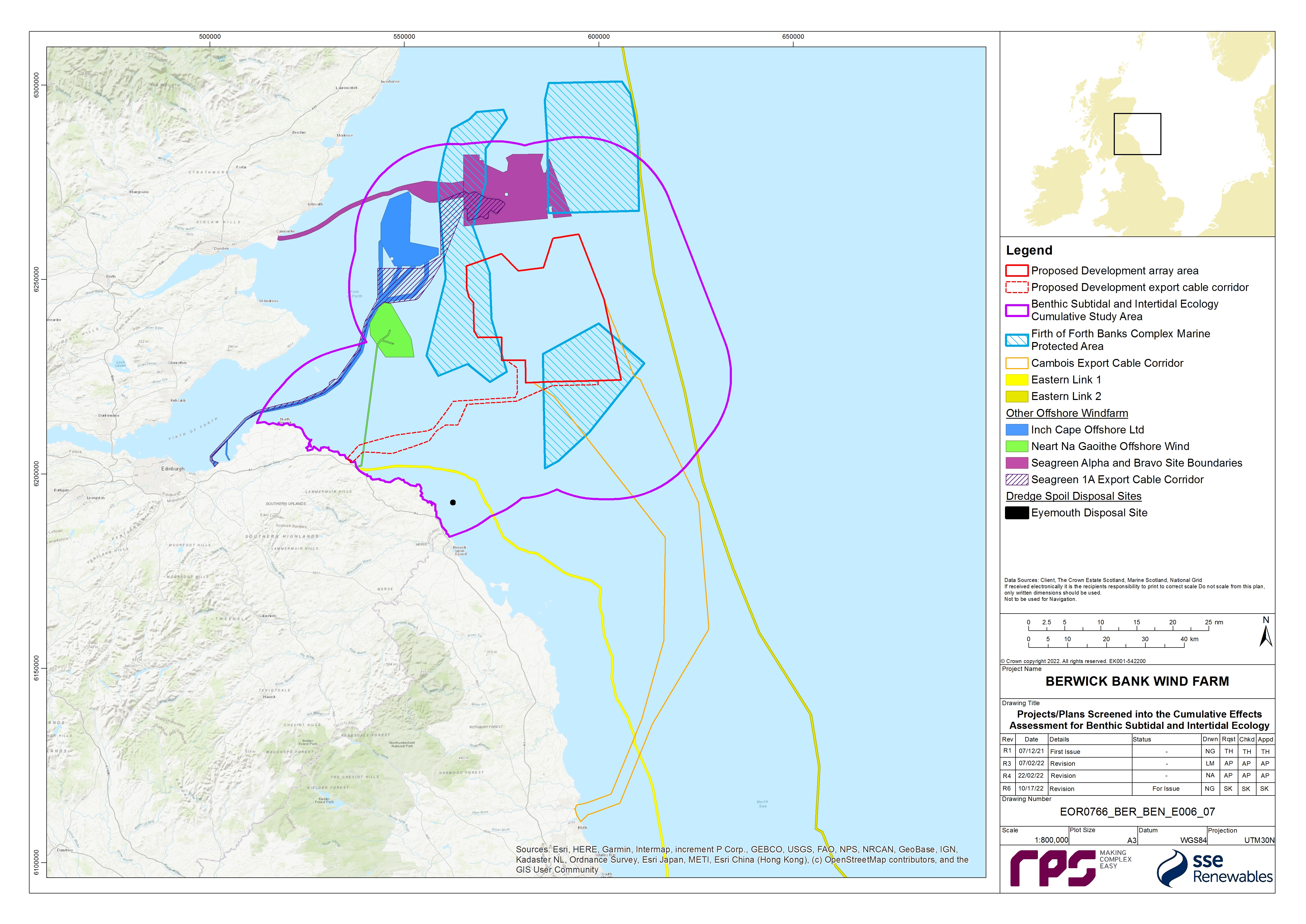
8.12.2. Maximum Design Scenario
- The maximum design scenarios identified in Table 8.34 Open ▸ have been selected as those having the potential to result in the greatest effect on an identified receptor or receptor group. The cumulative effects presented and assessed in this section have been selected from the details provided in volume 1, chapter 3 of the Offshore EIA Report as well as the information available on other projects and plans (see volume 3, appendix 6.4), to inform a ‘maximum design scenario’. Effects of greater adverse significance are not predicted to arise should any other development scenario, based on details within the PDE (e.g. different wind turbine layout), to that assessed here, be taken forward in the final design scheme.
Table 8.34: Maximum Design Scenario Considered for Each Impact as part of the Assessment of Likely Significant Cumulative Effects on Benthic Subtidal and Intertidal Ecology
8.12.3. Cumulative Effects Assessment
- An assessment of the likely significance of the cumulative effects of the Proposed Development upon benthic subtidal and intertidal ecology receptors arising from each identified impact is given in the following sections.
Temporary Habitat Loss/Disturbance
Tier 2
Construction phase
Magnitude of impact
Subtidal Habitat IEFs
- The construction and operation and maintenance of the projects/plans/activities shown in Table 8.34 Open ▸ may lead to cumulative temporary subtidal habitat loss/disturbance within the benthic subtidal and intertidal ecology CEA study area. A total cumulative area of habitat loss/disturbance has not been calculated as it is not appropriate to add all areas together. This would create an unrealistic total area as the majority of the disturbance would not occur at the same time, rather small proportions of habitat loss would occur across the CEA study area over the construction phase for the Proposed Development. Table 8.34 Open ▸ and Figure 8.7 Open ▸ show all projects/plans/activities considered in the Tier 2 assessment which are Inch Cape Offshore Wind Farm, Neart na Gaoithe Offshore Wind Farm, Seagreen 1, Seagreen 1A Project, Seagreen 1A Export Cable Corridor, Eastern Link 1, Eastern Link 2 and Eyemouth disposal site. There is small temporal overlap between construction phase for the Proposed Development and that of the Inch Cape Offshore Wind Farm and Seagreen 1A Project as well as the operation and maintenance phase once construction has been completed. The remaining projects will be in their operation and maintenance phase during the Proposed Developments construction phase.
- Table 8.35 Open ▸ shows the cumulative temporary habitat disturbance within the benthic subtidal and intertidal ecology cumulative study area, noting that the Seagreen 1A Project and Seagreen 1A Export Cable Corridor assessment does not provide estimates for temporary habitat disturbance associated with operation and maintenance. The maximum design scenario values for temporary habitat disturbance/loss during the construction phase of the Seagreen 1A Project (i.e. for the 36 wind turbines associated with this project) are presented in Table 8.35 Open ▸ and have been calculated, for the purposes of this CEA, using publicly available datasets (i.e. Seagreen Wind Energy, 2012b[21]; Seagreen Wind Energy, 2022[22]; and Seagreen Wind Energy 2020[23]). The maximum design scenario for temporary habitat loss/disturbance associated with the Seagreen 1A Project (i.e. 689,394 m2) has been subtracted from those provided in the Seagreen 1 assessment (Seagreen Wind Energy, 2012a) to calculate the realistic maximum design scenario for Seagreen 1 (i.e. to represent the scenario associated with 114 of the 150 wind turbines). This has approach has been adopted to prevent double counting and to ensure these projects are assessed realistically and proportionately. The Seagreen 1 assessment, as presented in the EIA for the project (Seagreen Wind Energy, 2012b), was undertaken on the basis that 114 of the 150 wind turbines for Seagreen 1 will have already been installed before construction of the Proposed Development is due to commence. Therefore, the Seagreen 1A Project will involve the construction of only the remaining 36 out of the 150 wind turbines.
- There is also expected to be temporary habitat disturbance from the construction and operation and maintenance of Eastern Link 1 and 2. The environmental appraisal for Eastern Link 1 does not give a specific value for temporary habitat loss in the project however it is expected to include a pre-installation footprint of 50 m and a 30 m footprint for cable installation. Additionally only 24% of the 176 km Eastern Link 1 cable will be within the Proposed Development benthic subtidal and intertidal study area therefore only a proportion of the overall impact will be cumulative. Table 8.35 Open ▸ shows that in the construction phase Eastern Link 2 will result in 15,200,000 m2 of temporary habitat disturbance however only 18% of the 436 km cables will occur with the Proposed Development benthic subtidal and intertidal ecology study area.
- There is potential for cumulative impacts to arise with disposal activities at the Eyemouth disposal site. The total area of the site is 664,761 m2 (see Table 8.35 Open ▸ ), however only a small portion of this would be affected at any one time by an individual disposal event.
- The maximum design scenario for habitat loss from the cumulative offshore wind farms, and the Eyemouth disposal site has been considered in this cumulative assessment. However, this is considered to be precautionary as activities associated with the operation and maintenance phase of wind farms occur intermittently throughout the phase and therefore are unlikely to completely overlap with the construction period of the Proposed Development.
- The cumulative impact is predicted to be of local spatial extent, short term duration, intermittent and high reversibility. It is predicted that the impact will affect the receptor directly. Given the minor temporal overlap in construction activities and that the operation and maintenance activities associated with the relevant projects will not add substantially to the total footprint associated with the Proposed Development and with only a proportion of the operation and maintenance operations occurring during the construction phase of the Proposed Development, the magnitude of the impact will not be greater than that assumed for the project alone. The magnitude is therefore, considered to be medium.
Table 8.35: Total Area and Component Parts of Temporary Habitat Disturbance of the Relevant Tier 2 Cumulative Impact Projects in the Construction Phase of the Proposed Development
Firth of Forth Banks Complex MPA
- Neither Inch Cape Offshore Wind Farm nor Neart na Gaoithe Offshore Wind Farm have a spatial overlap with the FFBC MPA, however Seagreen 1 and Seagreen 1A Project do overlap with the FFBC MPA. For the purposes of this assessment, the values for Seagreen 1 and Seagreen 1A Project have been reported together as a single value, as per the assessment that was presented in the MPA Assessment for Seagreen 1 (MS-LOT, 2014), which included the relevant elements of the Seagreen 1A Project
- The Seagreen 1 and Seagreen 1A Project, together, overlap with 7.17% of the FFBC MPA (MS-LOT, 2014), which represents 31.59% of the total combined area of Seagreen 1 and the Seagreen 1A Project. The Seagreen 1A Export Cable Corridor also overlaps with the FFBC MPA, the area of overlap represents 3.8% of the total area of the MPA (Seagreen Wind Energy Ltd., 2021). During the construction phase of Seagreen 1 and Seagreen 1A Project, up to 4,582,171 m2 of temporary habitat disturbance/loss is predicted to occur within the FFBC MPA, which accounts for 0.22% of the total area of the FFBC MPA. Neither Seagreen 1, Seagreen 1A Project or Seagreen 1A Export Cable Corridor provide specific figures for temporary habitat loss/disturbance in the operation and maintenance phase so it has not been possible to quantify the extent of temporary habitat loss that may occur within the boundary of the FFBC MPA, however it can be assumed that it will add a small amount on to the temporary habitat loss/disturbance from the Proposed Development based on the total extent of the overlap.
- The cumulative impact is predicted to be of regional spatial extent, medium term duration, intermittent and high reversibility. It is predicted that the impact will affect the receptor directly. The magnitude is therefore, considered to be medium.
Sensitivity of receptor
Subtidal Habitat IEFs
- The sensitivity of the IEFs are as detailed in paragraph 91 to 101 as well as Table 8.18 Open ▸ .
- The subtidal sand and muddy sand sediments IEF, and subtidal coarse and mixed sediments IEF are deemed to be of medium vulnerability, medium to low recoverability and regional value. The sensitivity of the IEFs is therefore, considered to be medium.
- The Sabellaria reef outside of an SAC IEF is deemed to be of medium vulnerability, medium recoverability, and national value. The sensitivity of the IEF is therefore, considered to be high.
- The seapens and burrowing megafauna IEF is deemed to be of high vulnerability, low recoverability and national value. The sensitivity of the IEF is therefore, considered to be high.
- The moderate energy subtidal rock, cobble/stony reef outside of an SAC and rocky reef outside an SAC IEFs are deemed to be of medium vulnerability and medium recoverability to temporary habitat disturbance (i.e. abrasion effects) and of national value. The sensitivity of the IEFs is therefore, considered to be medium.
- Although there is an impact on PMF(s), this will not create a significant impact on the national status of these features as only a small proportion of these PMFs will be affected compared to their overall national distribution and the temporary nature of the disturbance will limit the time over which disturbance will occur. Additionally, many will recover fully within a few years of the completion of construction, resulting in no change to their overall national status.
Firth of Forth Banks Complex MPA
- The sensitivity of the IEFs are as detailed in paragraphs 103 to 107, as well as Table 8.19 Open ▸ .
- The subtidal sands and gravels IEF, and the shelf banks and mounds IEF are deemed to be of medium vulnerability, medium recoverability and national value. The sensitivity of the IEFs is therefore, considered to be medium.
- The ocean quahog IEF is deemed to be of high vulnerability, low recoverability and national value. The sensitivity of the IEF is therefore, considered to be high.
Significance of the effect
Subtidal Habitat IEFs
- Overall, for the subtidal sand and muddy sand sediments IEF, the subtidal coarse and mixed sediments IEF, the moderate energy subtidal rock IEF, cobble/stony reef outside of an SAC IEF and rocky reef outside an SAC IEF, the magnitude of the cumulative impact is deemed to be medium and the sensitivity of the receptor is considered to be medium. The effect will, therefore, be of moderate adverse significance in the short term (i.e. within two years of completion of construction activities), with this decreasing to minor adverse significance in the medium to long term as the sediments and communities are predicted to recover. Therefore, minor effects are predicted in the long-term which are not significant in EIA terms. This is on the basis that current research suggests that hard and soft substrates can recover from this impact following the cessation of associated activities over time.
- Overall, for the seapens and burrowing megafauna IEF, and Sabellaria reef outside of an SAC IEFs the magnitude of the cumulative impact is deemed to be medium and the sensitivity of the receptor is considered to be high. The effect will, therefore, be of moderate adverse significance in the short term (i.e. within two years of completion of construction activities), with this decreasing to minor adverse significance in the medium to long term as the sediments and communities are predicted to recover. Therefore, minor effects are predicted in the long-term which are not significant in EIA terms. This is based on the limited scale of the impact on these habitats and their ability to recover after disturbance, over extended time periods.
Firth of Forth Banks Complex MPA
- Overall, for the subtidal sands and gravels IEF and the shelf banks and mounds IEF, the magnitude of the cumulative impact is deemed to be medium and the sensitivity of the receptor is considered to be medium. The effect will, therefore, be of moderate adverse significance in the short term (i.e. within two years of completion of construction activities), with this decreasing to minor adverse significance in the medium to long term as the sediments and communities are predicted to recover. Therefore, minor effects are predicted in the long-term which are not significant in EIA terms.
- Overall, for ocean quahog IEF the magnitude of the cumulative impact is deemed to be medium and the sensitivity of the receptor is considered to be high. The effect will, therefore, be of moderate adverse significance in the medium term, because of the slower rate of recovery for this species in comparison with surrounding habitats (i.e. within ten years of completion of construction activities), with this decreasing to minor adverse significance in the long term as the sediments and ocean quahog populations are predicted to recover. Therefore, minor effects are predicted in the long-term which are not significant in EIA terms.
Further mitigation and residual effect
- No benthic subtidal and intertidal ecology mitigation is considered necessary for the impact of temporary habitat loss/disturbance during the operation and maintenance phase because the likely effects, in the absence of further mitigation (beyond the designed in measures outlined in section 8.10), are not significant in EIA terms.
Operation and maintenance phase
Magnitude of impact
Subtidal Habitat IEFs
- Table 8.34 Open ▸ and Figure 8.7 Open ▸ show all projects/plans/activities considered in the Tier 2 assessment which are Inch Cape Offshore Wind Farm, Neart na Gaoithe Offshore Wind Farm, Seagreen 1, Seagreen 1A Project, Seagreen 1A Export Cable Corridor, Eastern Link 1, Eastern Link 2 and Eyemouth disposal site.
- During the operation and maintenance phase of the Proposed Development the other Tier 2 wind farms will reach their decommissioning age before the Proposed Development reaches its anticipated decommissioning in 2068. The operational lifetime of Inch Cape is expected to be up to 35 years, with construction ending in 2025 and decommissioning is expected in 2060 (Inch Cape Offshore Limited, 2018). The operational lifetime of Neart na Gaoithe is expected to be 25 years, with construction ending in 2023 and decommissioning is expected in 2049 (Mainstream Renewable Power, 2019). Seagreen 1 and Seagreen 1A Project have an operation and maintenance phase of 25 to 30 years which will lead to its decommissioning in 2048 – 2053 (Seagreen Wind Energy, 2012).
- The maximum design scenario for temporary habitat disturbance from each phase of the relevant cumulative offshore wind farms has been considered in this cumulative assessment. However, this is considered to be precautionary as activities associated with the operation and maintenance of the Proposed Development will occur intermittently throughout the lifetime of the Proposed Development and therefore are unlikely to temporally overlap with the decommissioning periods of the other offshore wind farms. Furthermore, Inch Cape Offshore Wind Farm and Neart na Gaoithe Offshore Wind Farm assume in their environmental statements that the decommissioning process will produce similar levels of temporary habitat disturbance to their construction phase however this is likely to be an over estimation because not all of the infrastructure is likely to be removed from the seabed in the final plans (Inch Cape Offshore Limited, 2018; Mainstream Renewable Power, 2019), The EIA for Seagreen 1 (including the elements of the Seagreen 1A Project) however does not include any assumption for habitat disturbance associated with maintenance activities although it is assumed that, during decommissioning, all structures will be removed and so the magnitude of the effect is that same as the construction phase impact (Seagreen Wind Energy, 2012). Values for the maximum design scenario for Seagreen 1 and the Seagreen 1A Project have been determined using the publicly available information detailed in paragraph 490.
- The environmental assessment for Seagreen 1A Export Cable Corridor provides no values for the operation and maintenance of the cable; however, it is expected to be small in comparison with the Proposed Development and the other offshore wind farms considered. The impacts during decommissioning are expected to be similar, and less significant, than those predicted during installation (Seagreen Wind Energy Ltd., 2021).
- The environmental appraisals for Eastern Link 1 (National Grid Electricity Transmission and Scottish Power Transmission, 2022) and Eastern Link 2 (National Grid Electricity Transmission and Scottish Hydro Electric Transmission plc, 2022) do not provide detail regarding the temporary habitat disturbance of their maintenance activities. They do however expect it to be highly reduced from the construction phase and repair works are likely to be highly localised to the area of concern and therefore the spatial extent of any impacts would be small in extent.
- Currently it is unknown when the Eyemouth disposal site may close therefore to ensure the worst-case scenario it has been assumed it will still be open and the area of temporary habitat loss can be seen in Table 8.36 Open ▸ (MS-LOT, 2018).
- The cumulative impact is predicted to be of local spatial extent, short term duration, intermittent and high reversibility. It is predicted that the impact will affect the receptor directly. The magnitude is therefore, considered to be low.
Table 8.36: Total Area and Component Parts of Temporary Habitat Disturbance of the Relevant Tier 2 Cumulative Projects in the Operation and Maintenance Phase of the Proposed Development
Firth of Forth Banks Complex MPA
- Neither Inch Cape Offshore Wind Farm, nor Neart na Gaoithe Offshore Wind Farm have a spatial overlap with the FFBC MPA, however Seagreen 1 and Seagreen 1A Project do overlap with the FFBC MPA. In total Seagreen 1 and Seagreen 1A Project overlap with 7.17% of the FFBC MPA, which represents 31.59% of the total area of Seagreen 1 and Seagreen 1A Project. Seagreen 1A Export Cable Corridor also overlaps with the FFBC MPA, the area of overlap represents 3.8% of the total area of the MPA (Seagreen Wind Energy Ltd., 2021).
- The MPA assessment for Seagreen 1 (which included the Seagreen 1A Project elements) (MS-LOT, 2014) provides figures for the decommissioning of the project (assuming the worst-case scenario is the removal of all infrastructure, therefore it is the same as construction) but not operation and maintenance. Based on this information 287,961 m2 of temporary habitat disturbance will occur as a result of these projects within the FFBC MPA (0.12% of the total area of the MPA).
- The cumulative impact is predicted to be of local spatial extent, short term duration, intermittent and high reversibility. It is predicted that the impact will affect the receptor directly. The magnitude is therefore, considered to be low.
Sensitivity of the receptor
Subtidal Habitat IEFs
- The sensitivity of the IEFs are as detailed in paragraphs 91 to 101 as well as Table 8.19 Open ▸ of the project alone assessment and paragraph 499 to 503 in the CEA assessment.
Firth of Forth Banks Complex MPA
- The sensitivity of the IEFs are as detailed in paragraphs 103 to 107, as well as Table 8.20 Open ▸ in the project alone assessment and in paragraphs 505 and 506 in the CEA assessment.
Significance of the effect
Subtidal Habitat IEFs
- Overall, for the subtidal sand and muddy sand sediments IEF, the subtidal coarse and mixed sediments IEF, the moderate energy subtidal rock IEF, cobble/stony reef outside of an SAC IEF and rocky reef outside an SAC IEF the magnitude of the cumulative impact is deemed to be low, and the sensitivity of the receptor is considered to be medium. The effect will, therefore, be of minor adverse significance, which is not significant in EIA terms, because of the small scale of the impact and the high rate of recovery for these habitats.
- Overall, for the seapens and burrowing megafauna, and Sabellaria reef outside of an SAC IEFs, the magnitude of the cumulative impact is deemed to be low, and the sensitivity of the receptor is considered to be high. The effect will, therefore, be of minor adverse significance, which is not significant in EIA terms, because of the small scale of the impact and the high rate of recovery for these habitats.
Firth of Forth Banks Complex MPA
- Overall, for the subtidal sands and gravels IEF and the shelf banks and mounds IEF, the magnitude of the cumulative impact is deemed to be low, and the sensitivity of the receptor is considered to be medium. The effect will, therefore, be of minor adverse significance, which is not significant in EIA terms, because of the small scale of the impact and the high rate of recovery for these habitats.
- Overall, for ocean quahog IEF the magnitude of the cumulative impact is deemed to be low, and the sensitivity of the receptor is considered to be high. The effect will, therefore, be of minor adverse significance, which is not significant in EIA terms. This has been concluded on the basis that only a very small proportion of the habitat for this species in the south western North Sea is predicted to be affected and, furthermore, as described in section 8.7, with further detail in the Benthic Subtidal and Intertidal Ecology Technical Report (volume 3, appendix 8.1), this species was recorded is very low abundances within the site-specific surveys and predominately as juveniles.
Further mitigation and residual effect
- No benthic subtidal and intertidal ecology mitigation is considered necessary for the impact of temporary habitat loss/disturbance during the operation and maintenance phase because the likely effects, in the absence of further mitigation (beyond the designed in measures outlined in section 8.10), are not significant in EIA terms.
Decommissioning phase
- There are no Tier 2 projects active in the Proposed Development decommissioning phase to consider for cumulative impacts based on current knowledge. Any programme changes resulting in decommissioning overlap with the Proposed Development are considered in paragraph 482.
Tier 3
Construction phase
Magnitude of impact
Subtidal Habitat IEFs
- The Tier 3 projects which have been identified in the CEA with the potential to result in cumulative temporary habitat loss with the Proposed Development is the Cambois connection.
- Values for the temporary habitat disturbance/loss associated with the construction of the Cambois connection are detailed in Table 8.37 Open ▸ . The values for the Cambois connection are based on information presented in the Scoping Report submitted in October 2022.
Table 8.37: Total Area and Component Parts of Temporary Habitat Disturbance of the Relevant Tier 3 Cumulative Impact Projects in the Construction Phase of the Proposed Development
- Figure 8.7 Open ▸ shows that the Cambois connection extends beyond the Proposed Development benthic subtidal and intertidal cumulative study area, therefore the majority of this disturbance will not spatially overlap with the Proposed Development. Up to 180 km of Cambois connection cables (i.e. four cables each up to 45 km in length) may however be installed within the Proposed Development array area which could result in up to 4.5 km2 of repeat disturbance to benthic habitats within the Proposed Development array area previously impacted during the construction of the Proposed Development. The disturbance associated with the Cambois connection cable installation will however be highly localised (25 m width of potential disturbance) and so the potential for repeat disturbance is considered low and unlikely to lead to cumulative impacts.
- The cumulative impact is predicted to be of local spatial extent, short term duration, intermittent and high reversibility. It is predicted that the impact will affect the receptor directly. The magnitude is therefore, considered to be medium.
Firth of Forth Banks Complex MPA
- In addition to the 4,582,171 m2 of temporary habitat disturbance from the construction of Seagreen 1 and the Seagreen 1A Project, up to 6.3 m2 of temporary habitat disturbance/loss will result from the installation of Cambois connection which represents 0.30% of the total area of the FFBC MPA or 1.16% of Berwick Bank part of the MPA. The construction phases of Seagreen 1 and Seagreen 1A Project will not however overlap with the construction of Cambois connection, and so will not interact.
- The cumulative impact is predicted to be of regional spatial extent, medium term duration, intermittent and high reversibility. It is predicted that the impact will affect the receptor directly. The magnitude is therefore, considered to be medium.
Sensitivity of the receptor
Subtidal Habitat IEFs
Firth of Forth Banks Complex MPA
- The sensitivities of the Firth of Forth Banks Complex MPA IEFs are detailed in paragraphs 504 to 506.
Significance of the effect
Subtidal Habitat IEFs
- Overall, for the subtidal sand and muddy sand sediments IEF, the subtidal coarse and mixed sediments IEF, moderate energy subtidal rock IEF, cobble/stony reef outside of an SAC IEF and rocky reef outside an SAC IEF the magnitude of the cumulative impact is deemed to be medium, and the sensitivity of the receptor is considered to be medium. The effect will, therefore, be of moderate adverse significance in the short term (i.e. within two years of completion of construction activities), with this decreasing to minor adverse significance in the medium to long term as the sediments and communities are predicted to recover. Therefore, minor effects are predicted in the long-term which are not significant in EIA terms.
- Overall, for the seapens and burrowing megafauna IEF and Sabellaria reef outside of an SAC IEF, the magnitude of the cumulative impact is deemed to be medium, and the sensitivity of the receptor is considered to be high. The effect will, therefore, be of moderate adverse significance in the short term (i.e. within two years of completion of construction activities) because of the high likelihood of recovery for these communities despite an increase in disturbance which is spread over a large area, with this decreasing to minor adverse significance in the medium to long term as the sediments and communities are predicted to recover. Therefore, minor effects are predicted in the long-term which are not significant in EIA terms.
Firth of Forth Banks Complex MPA
- Overall, for the subtidal sands and gravels IEF and the shelf banks and mounds IEF, the magnitude of the cumulative impact is deemed to be medium, and the sensitivity of the receptor is considered to be medium. The effect will, therefore, be of moderate adverse significance in the short term (i.e. within two years of completion of construction activities), with this decreasing to minor adverse significance in the medium to long term as the sediments and communities are predicted to recover. Therefore, minor effects are predicted in the long-term which are not significant in EIA terms.
- Overall, for ocean quahog IEF the magnitude of the cumulative impact is deemed to be medium, and the sensitivity of the receptor is considered to be high. The effect will, therefore, be of moderate adverse significance in the medium term (i.e. within ten years of completion of construction activities) because of the increase in magnitude leading to more widespread disturbance, with this decreasing to minor adverse significance in the long term as the sediments and ocean quahog populations are predicted to recover. Therefore, minor effects are predicted in the long-term which are not significant in EIA terms.
Further mitigation and residual effect
- No benthic subtidal and intertidal ecology mitigation is considered necessary for the impact of temporary habitat loss/disturbance during the operation and maintenance phase because the predicted effects, in the absence of further mitigation (beyond the designed in measures outlined in section 8.10), are not significant in EIA terms.
Operation and maintenance phase
- The Tier 3 projects which have been identified in the CEA with the potential to result in cumulative temporary habitat loss with the operation and maintenance of the Proposed Development is Cambois connection. There are also no specific values for the operation and maintenance of Cambois connection which will occur during the operation and maintenance phase of the Proposed Development. No quantification of Tier 3 cumulative impacts is possible at this stage.as a result, no assessment of the cumulative impacts of these projects can be made.
Decommissioning phase
- There are not any Tier 3 projects active in the Proposed Development decommissioning phase to consider for cumulative impacts based on current knowledge. Any programme changes resulting in decommissioning overlap with the Proposed Development are considered in paragraph 482.
Increased Suspended Sediment Concentrations and Associated Sediment Deposition
- Increased suspended sediment concentrations and associated deposition may arise due to the seabed preparation, installation of the wind turbines and OSP/Offshore convertor station platform foundations, the installation and/or maintenance of inter-array cables and the offshore export cables and associated decommissioning activities. Should the other projects cited take place concurrently with the Proposed Development construction or maintenance, there is potential for cumulative increases in suspended sediment concentrations and sediment deposition.
Tier 2
Construction phase
Magnitude of impact
Subtidal Habitat IEFs
- The magnitude of the increase in suspended sediment concentrations and associated deposition arising from the installation of wind turbines and OSP/Offshore convertor station platform foundations, inter-array cables and offshore export cables during the construction phase, has been assessed as low for the Proposed Development alone, as described in section 8.11.
- The construction phase of the Proposed Development coincides with the construction phase of the Seagreen 1A Project and the Inch Cape Offshore Wind Farm. It is noted that the Seagreen 1A Project is due for completion in the third quarter of 2025 with the installation of wind turbines being undertaken in the final months. Therefore, the installation of cables and foundations for this project will not coincide with the Proposed Development construction phase. The Inch Cape Offshore Wind Farm will be in the final year of construction, with the installation of the offshore export cables being programmed for the period of overlap. The offshore export cable corridor for Inch Cape is located to the east of the Proposed Development, beyond the Firth of Forth Banks Complex MPA and should trenching activities be undertaken simultaneously the sediment plumes would not interact with those from the Proposed Development.
- During the Proposed Development’s construction phase the Neart na Gaoithe Offshore Wind Farm and the Seagreen 1A Export Cable will be in the operational phase and maintenance activities may result in increased SSCs, however these activities would be of limited spatial extent and frequency and unlikely to interact with sediment plumes from the Proposed Development.
- The Eastern Link 1 Cable has Scottish landfall near Thorntonloch Beach, East Lothian. The landfall installation is proposed to be by HDD and although it is not yet confirmed which subsea trenching techniques will be used to install the cables, it is anticipated that mechanical ploughing or cutting and/or water jetting or Mass Flow Excavation (MFE) techniques will be used at different points along the route, in response to the seabed sediment conditions. Installation of the cables into soft sediments will seek to achieve a target burial depth of at least 1.5 m to 2 m and below the depth of mobile sediments depending on the nature of the seabed and potential hazards.
- The Eastern Link 2 Cable runs to the east of the Proposed Development, skirting the FFBC MPA. For the extent of the overlap with the benthic subtidal and intertidal ecology cumulative study area this is an offshore marine cable. The preferred subsea cable protection method is burial through trenching. It is not yet confirmed what subsea trenching equipment will be used to install the cables; however, it is anticipated similar methods to those proposed for Eastern Link 1 may be required, but this is dependent on the seabed conditions present within the Proposed Development export cable corridor.
- The CEA considers sea disposal of dredged material at the Eyemouth disposal site, located 31 km and 16.5 km from the Proposed Development array area and Proposed Development export cable corridor respectively. If offshore cable installation and dredge material deposition coincided both resultant plumes would be advected on the tidal currents, they would travel in parallel, and not towards one another, and are unlikely to interact in the event that offshore cable installation coincides with the use of the licensed sea disposal site.
- The cumulative impact is predicted to be of local spatial extent, short term duration and intermittent and of high reversibility. The additional impact of the cumulative projects is negligible therefore the magnitude considered to be low.
Intertidal Habitat IEFs
- The magnitude of the increase in suspended sediment concentrations and associated deposition arising from the installation of wind turbines and OSP/Offshore convertor station platform foundations, inter-array cables and offshore export cables during the construction phase in the project alone was expected to be negligible. The impact of the cumulative Tier 2 projects is also expected to be minimal with other projects located further offshore or using the same intermittent and temporary methods of installation.
- The cumulative impact is predicted to be of local spatial extent, short term duration and intermittent and of high reversibility. The magnitude is therefore, considered to be negligible.
Firth of Forth Banks Complex MPA
- A number of the projects in Tier 2 will create an increase in suspended sediment and associated deposition during the Proposed Development construction period which may result in an impact upon the FFBC MPA. Activities contributing to this impact include wind turbine and OSP/Offshore convertor station platform foundation installation, cable installation and maintenance works. One such example is the offshore export cable corridor for Inch Cape which is located to the east of the Proposed Development, beyond the Forth Banks Complex ncMPA. However, it the event that trenching activities be undertaken simultaneously, the sediment plumes would not interact with those from the Proposed Development. Seagreen 1 and Seagreen 1A may have maintenance works within the FFBC MPA during the Proposed Development construction phase which may interact with the plume created by the Proposed Development however the likelihood of a temporal overlap is very low and is unlikely to result effects greater than those assessed for the project alone assessment.
- The cumulative impact is predicted to be of local spatial extent, short term duration and intermittent and of high reversibility. The magnitude is therefore, considered to be low.
Berwickshire and North Northumberland Coast SAC
- It is predicted that the impact would not affect the SAC or other receptors as the resultant plumes from offshore cable installation for the Proposed Development and dredge material deposition at the Eyemouth disposal site are unlikely to interact and create a cumulative impact.
- The cumulative impact is predicted to be of local spatial extent, short term duration and intermittent and of high reversibility. The magnitude is therefore, considered to be negligible.
Sensitivity of receptor
Subtidal Habitat IEFs
- The sensitivity of the IEFs are as detailed in paragraphs 161 to 170, as well as Table 8.21 Open ▸ .
- The moderate energy subtidal rock IEF, cobble/stony reef outside of an SAC IEF, and rocky reef outside an SAC IEF is deemed to be of low vulnerability, medium recoverability, and national value. The sensitivity of the IEF is therefore, considered to be medium.
- The subtidal sand and muddy sand sediments IEF and the subtidal coarse and mixed sediments IEF are deemed to be of low vulnerability, high recoverability, and regional value. The sensitivity of the IEFs is therefore, considered to be low.
- The seapens and burrowing megafauna IEF and the Sabellaria reef outside of an SAC IEF are deemed to be not sensitive and of national value. The sensitivity of the IEFs is therefore, considered to be negligible.
- Although there is an impact on PMF(s) this will not create significant impact on the national status of these features because of the negligible to low sensitivity of the IEFs and the limited scale of the impact only noticeably impacting habitats in the immediate vicinity of new infrastructure installation.
Intertidal Habitat IEFs
- The sensitivity of the IEFs are as detailed in paragraphs 171 to 173, as well as Table 8.21 Open ▸ .
- The intertidal rock IEF and fucus dominated intertidal rock IEFs are deemed to be of medium vulnerability and medium recovery and national value. The sensitivity of the IEFs is therefore, considered to be medium.
- The intertidal sands IEF is deemed to be not sensitive and of national value. The sensitivity of the IEF is therefore, considered to be negligible.
Firth of Forth Banks Complex MPA
- The sensitivity of the IEFs are as detailed in paragraphs 176 to 180, as well as Table 8.22 Open ▸ .
- The subtidal sands and gravels IEF, and the shelf banks and mounds IEF are deemed to be of low vulnerability, high recoverability, and national value. The sensitivity of the IEFs is therefore, considered to be low.
- The ocean quahog IEF is deemed to be not sensitive and of national value. The sensitivity of the IEF is therefore, considered to be negligible.
Berwickshire and North Northumberland Coast SAC
- The sensitivity of the IEFs are as detailed in paragraphs 181 to 189, as well as Table 8.23 Open ▸ .
- The mudflats and sandflats not covered by seawater at low tide IEF is deemed to be of low vulnerability, high recoverability and international value. The sensitivity of the IEF is therefore, considered to be low.
- The reefs (subtidal and intertidal rocky reef) IEF is deemed to be of low vulnerability, high recoverability and international value. The sensitivity of the IEF is therefore, considered to be medium.
- The submerged or partially submerged sea caves IEF is deemed to be of medium vulnerability, medium recoverability and international value. The sensitivity of the IEF is therefore, considered to be medium.
- The large shallow inlets and bays IEF is deemed to be of low vulnerability, high recoverability and international value. The sensitivity of the IEF is therefore, considered to be low.
Significance of effect
Subtidal Habitat IEFs
- Overall, for the cobble/stony reef outside of an SAC IEF, the rocky reef outside an SAC IEF and the moderate energy subtidal rock IEF, the magnitude of the impact is deemed to be low and the sensitivity of the receptors is considered to be low. The effect will, therefore, be of minor adverse significance, which is not significant in EIA terms, because of the high likelihood of recovery for these IEF to this short-term impact.
- Overall, for the subtidal sand and muddy sand sediments IEF, and the subtidal coarse and mixed sediments IEF, the magnitude of the cumulative impact is deemed to be low and the sensitivity of the receptor is considered to be low. The cumulative impact will, therefore, be of minor adverse significance, which is not significant in EIA terms, because of the high likelihood of recovery for these IEF to this short-term impact.
- Overall, for the seapens and burrowing megafauna IEF and the Sabellaria reef outside of an SAC IEF, the magnitude of the cumulative impact is deemed to be low and the sensitivity of the receptor is considered to be negligible. The cumulative impact will, therefore, be of minor adverse significance, which is not significant in EIA terms, because of the high likelihood of recovery for these IEF to this short-term impact.
Intertidal Habitat IEFs
- Overall, for the intertidal rock IEF and the fucus dominated intertidal rock IEF, the magnitude of the cumulative impact is deemed to be negligible and the sensitivity of the receptor is considered to be medium. The cumulative impact will, therefore, be of negligible adverse significance, which is not significant in EIA terms, because of the high likelihood of recovery for these IEF to this short-term impact.
- Overall, for the intertidal sands IEF, the magnitude of the cumulative impact is deemed to be negligible and the sensitivity of the receptor is considered to be negligible. The cumulative impact will, therefore, be of negligible adverse significance, which is not significant in EIA terms, because of the high likelihood of recovery for these IEF to this short-term impact.
Firth of Forth Banks Complex MPA
- Overall, for the subtidal sands and gravels IEF, and the shelf banks and mounds IEF, the magnitude of the cumulative impact is deemed to be low and the sensitivity of the receptor is considered to be low. The cumulative impact will, therefore, be of minor adverse significance, which is not significant in EIA terms, because of the high likelihood of recovery for these IEF to this short term impact.
- Overall, for the ocean quahog IEF, the magnitude of the cumulative impact is deemed to be low and the sensitivity of the receptor is considered to be negligible. The cumulative impact will, therefore, be of minor adverse significance, which is not significant in EIA terms, because of the high likelihood of recovery for these IEF to this short term impact.
Berwickshire and North Northumberland Coast SAC
- Overall, for the mudflats and sandflats not covered by seawater at low tide SAC IEF, the magnitude of the cumulative impact is deemed to be negligible and the sensitivity of the receptor is considered to be low. The cumulative impact will, therefore, be of negligible adverse significance, which is not significant in EIA terms, because of the high likelihood of recovery from this impact and the large distance between this IEF and any potentially active construction activities.
- Overall, for the reefs (subtidal and intertidal rocky reef) IEF, the magnitude of the cumulative impact is deemed to be negligible and the sensitivity of the receptor is considered to be medium. The cumulative impact will, therefore, be of negligible adverse significance, which is not significant in EIA terms, because of the high likelihood of recovery from this impact and the large distance between this IEF and any potentially active construction activities.
- Overall, the submerged or partially submerged sea caves IEF, the magnitude of the cumulative impact is deemed to be negligible and the sensitivity of the receptor is considered to be medium. The cumulative impact will, therefore, be of negligible adverse significance, which is not significant in EIA terms, because of the high likelihood of recovery from this impact and the large distance between this IEF and any potentially active construction activities.
- Overall, for the large shallow inlets and bays IEF, the magnitude of the cumulative impact is deemed to be negligible and the sensitivity of the receptor is considered to be low. The cumulative impact will, therefore, be of negligible adverse significance, which is not significant in EIA terms, because of the high likelihood of recovery from this impact and the large distance between this IEF and any potentially active construction activities.
Further mitigation and residual effect
- No benthic subtidal and intertidal ecology mitigation is considered necessary for the impact of increases in SSC and associated sediment deposition during the construction phase because the predicted effects in the absence of further mitigation (beyond the designed in measures outlined in section 8.10), are not significant in EIA terms.
Operation and maintenance phase
Magnitude of impact
Subtidal Habitat IEFs
- The magnitude of the increase in suspended sediment concentrations and associated deposition arising from maintenance activities, has been assessed as negligible for the Proposed Development alone, as described in section 8.11.
- The Tier 2 projects outlined in Table 8.34 Open ▸ will all be in their operation and maintenance phases during the operation and maintenance phase of the Proposed Development. Therefore, as previously, maintenance activities associated with these projects may result in increased SSCs, however these activities would be of limited spatial extent and frequency. The cumulative impacts would therefore be of a lesser magnitude than the Tier 2 construction phase assessment (i.e. also negligible).
- Potential cumulative impacts may relate to maintenance and reburial of the offshore export cables coinciding with the use of the Eyemouth disposal site. Maintenance activities are both intermittent and of smaller scale than the construction phase and therefore any potential cumulative impacts are less likely to occur and be of a smaller scale.
- The cumulative impact is predicted to be of local spatial extent, short term duration, intermittent and of high reversibility. The magnitude is therefore, considered to be negligible.
Intertidal Habitat IEFs
- The magnitude of the increase in suspended sediment concentrations and associated deposition arising from the installation of wind turbines and OSP/Offshore convertor station platform foundations, inter-array cables and offshore export cables during the operation and maintenance phase for the Proposed Development alone was predicted to be negligible. The impact of the cumulative Tier 2 projects is also expected to be minimal with other projects located further offshore or using the same intermittent and temporary methods of installation.
- The cumulative impact is predicted to be of local spatial extent, short term duration and intermittent and of high reversibility. The magnitude is therefore, considered to be negligible.
Firth of Forth Bank Complex MPA
- It is predicted that the impact from the cumulative projects would result in additional impact upon the FFBC MPA although the overall effect is likely to similar to the Proposed Development.
- The cumulative impact is predicted to be of local spatial extent, short term duration, intermittent and of high reversibility. The magnitude is therefore, considered to be low.
Berwickshire and North Northumberland Coast SAC
- It is predicted that the impact would not affect the MPA or other receptors as increased suspended sediments from maintenance activities at the Proposed Development and at the Eyemouth disposal site are likely to be intermittent and on a smaller scale than the construction phase.
- The cumulative impact is predicted to be of local spatial extent, short term duration, intermittent and of high reversibility. The magnitude is therefore, considered to be negligible.
Sensitivity of the receptor
Subtidal Habitat IEFs
- The sensitivity of the IEFs are as detailed in paragraphs 161 to 170, as well as Table 8.21 Open ▸ in the project alone assessment, and in paragraphs 561 to 563 of the CEA assessment.
Intertidal Habitat IEFs
- The sensitivity of the IEFs are as detailed in paragraphs 171 to 173, as well as Table 8.21 Open ▸ in the project alone assessment, and in paragraphs 565 and 566 of the CEA assessment.
Firth of Forth Banks Complex MPA
- The sensitivity of the IEFs are as detailed in paragraphs 176 to 180, as well as Table 8.22 Open ▸ in the project alone assessment, and in paragraphs 568 and 569 of the CEA assessment.
Berwickshire and North Northumberland Coast SAC
- The sensitivity of the IEFs are as detailed in paragraphs 181 to 189, as well as Table 8.23 Open ▸ in the project alone assessment, and in paragraphs 571 to 574 of the CEA assessment.
Significance of the effect
Subtidal Habitat IEFs
- Overall, for the cobble/stony reef outside of an SAC IEF, the rocky reef outside an SAC IEF and the moderate energy subtidal rock IEF, the magnitude of the impact is deemed to be negligible, and the sensitivity of the receptors is considered to be low. The effect will, therefore, be of negligible adverse significance, which is not significant in EIA terms, because of the very small magnitude and intermittent nature of this impact in this phase.
- Overall, for the subtidal sand and muddy sand sediments IEF and the subtidal coarse and mixed sediments IEF, the magnitude of the cumulative impact is deemed to be negligible, and the sensitivity of the receptor is considered to be low. The cumulative impact will, therefore, be of negligible adverse significance, which is not significant in EIA terms, because of the very small magnitude and intermittent nature of this impact in this phase.
- Overall, for the seapens and burrowing megafauna IEF and the Sabellaria reef outside of an SAC IEF, the magnitude of the cumulative impact is deemed to be negligible, and the sensitivity of the receptor is considered to be negligible. The cumulative impact will, therefore, be of negligible adverse significance, which is not significant in EIA terms.
Intertidal Habitat IEFs
- Overall, for the intertidal rock IEF and the fucus dominated intertidal rock IEF, the magnitude of the cumulative impact is deemed to be negligible, and the sensitivity of the receptor is considered to be medium. The cumulative impact will, therefore, be of negligible adverse significance, which is not significant in EIA terms, because of the very small magnitude and intermittent nature of this impact in this phase.
- Overall, for the intertidal sands IEF, the magnitude of the cumulative impact is deemed to be negligible, and the sensitivity of the receptor is considered to be negligible. The cumulative impact will, therefore, be of negligible adverse significance, which is not significant in EIA terms.
Firth of Forth Banks Complex MPA
- Overall, for the subtidal sands and gravels IEF, and the shelf banks and mounds IEF, the magnitude of the cumulative impact is deemed to be low, and the sensitivity of the receptor is considered to be low. The cumulative impact will, therefore, be of minor adverse significance, which is not significant in EIA terms, because of the very small magnitude and intermittent nature of this impact in this phase.
- Overall, for the ocean quahog IEF, the magnitude of the cumulative impact is deemed to be low, and the sensitivity of the receptor is considered to be negligible. The cumulative impact will, therefore, be of negligible adverse significance, which is not significant in EIA terms.
Berwickshire and North Northumberland Coast SAC
- Overall, for the mudflats and sandflats not covered by seawater at low tide SAC IEF, the magnitude of the impact is deemed to be negligible, and the sensitivity of the receptors is considered to be low. The cumulative impact will, therefore, be of negligible adverse significance, which is not significant in EIA terms, because of the very small magnitude and intermittent nature of this impact in this phase as well as the large distance between this SAC and the Proposed Development.
- Overall, for the reefs (subtidal and intertidal rocky reef) IEF, the magnitude of the cumulative impact is deemed to be negligible and the sensitivity of the receptor is considered to be medium. The cumulative impact will, therefore, be of negligible adverse significance, which is not significant in EIA terms, because of the very small magnitude and intermittent nature of this impact in this phase as well as the large distance between this SAC and the Proposed Development, which is not significant in EIA terms.
- Overall, the submerged or partially submerged sea caves IEF, the magnitude of the cumulative impact is deemed to be negligible and the sensitivity of the receptor is considered to be medium. The cumulative impact will, therefore, be of negligible adverse significance, which is not significant in EIA terms, because of the very small magnitude and intermittent nature of this impact in this phase as well as the large distance between this SAC and the Proposed Development.
- Overall, for the large shallow inlets and bays IEF, the magnitude of the cumulative impact is deemed to be negligible and the sensitivity of the receptor is considered to be low. The cumulative impact will, therefore, be of negligible adverse significance, which is not significant in EIA terms.
Further mitigation and residual effect
- No benthic subtidal and intertidal ecology mitigation is considered necessary for the impact of increases in SSC and associated sediment deposition during the construction phase because the likely effects in the absence of further mitigation (beyond the designed in measures outlined in section 8.10), are not significant in EIA terms.
Decommissioning phase
- As per the maximum design scenario for the Proposed Development, during the decommissioning phase all structures above the seabed would be removed. It is proposed to remove all export, inter-array and inter-connector cables and scour protection where possible and appropriate to do so. During decommissioning cables would be removed by similar processes as undertaken during installation therefore increases in SSC would be of a similar form and magnitude. Following decommissioning, changes in suspended sediments concentration and sedimentation would return to baseline levels as it is anticipated that all structures above the seabed level will be completely removed and no further operation to disturb the seabed would be required. Therefore, the assessment for the construction phase is deemed equally applicable for the decommissioning phase and is not repeated here (see paragraphs 546 to 586).
Tier 3
Construction phase
Magnitude of impact
Subtidal Habitat IEFs
- During the construction phase of the Proposed Development there is the potential for cumulative impacts with three Tier 3 cable installations. The Cambois connection is a 170 km cable route extending southwards from the Proposed Development array area. Scoping indicates the project will consist of up to four cables installed in 2 m wide trenches up to 3 m in depth. Installation techniques may include jet trenching, cable ploughing and mass flow excavator, as ground conditions dictate. Site preparation will be required, such as boulder and sand wave clearance as part of the approximately two year construction programme.
- The cumulative impact is predicted to be of local spatial extent, short term duration, intermittent and of high reversibility. The magnitude is therefore, considered to be low.
Intertidal Habitat IEFs
- The installation parameters, described in paragraph 613, are similar to those of the Proposed Development and therefore the magnitude of the impact on the coastal receptors this would be negligible. The other projects described in this tier are unlikely to affect the intertidal habitats.
- The cumulative impact is predicted to be of local spatial extent, short term duration, intermittent and of high reversibility. The magnitude is therefore, considered to be negligible.
Firth of Forth Banks Complex MPA
- The Cambois connection export cable route extending southwards from the Proposed Development array area will directly impact the Firth of Forth Banks Complex MPA, however the scoping report does not provide detail on the potential increase in suspended sediment and associated deposition. It can be assumed that the impact will likely be similar to the installation of the offshore export cables and is unlikely to result in a cumulative impact greater than the project alone assessment.
- The cumulative impact is predicted to be of local spatial extent, short term duration and intermittent and of high reversibility. The magnitude is therefore, considered to be low.
Berwickshire and North Northumberland Coast SAC
- As a coastal SAC the magnitude as discussed in paragraph 616 is applicable and therefore the cumulative impact is predicted to be of local spatial extent, short term duration and intermittent and of high reversibility. The magnitude is therefore, considered to be negligible.
Sensitivity of the receptor
Subtidal Habitat IEFs
- The sensitivity of the IEFs are as detailed in paragraphs 161 to 170, as well as Table 8.21 Open ▸ in the project alone assessment, and in paragraphs 561 to 563 of the CEA assessment.
Intertidal Habitat IEFs
- The sensitivity of the IEFs are as detailed in paragraphs 171 to 173, as well as Table 8.21 Open ▸ in the project alone assessment, and in paragraphs 565 and 566 of the CEA assessment.
Firth of Forth Banks Complex MPA
- The sensitivity of the IEFs are as detailed in paragraphs 176 to 180, as well as Table 8.22 Open ▸ in the project alone assessment, and in paragraphs 568 and 569 of the CEA assessment.
Berwickshire and North Northumberland Coast SAC
- The sensitivity of the IEFs are as detailed in paragraphs 181 to 189, as well as Table 8.23 Open ▸ in the project alone assessment, and in paragraphs 571 to 574 of the CEA assessment.
Significance of the effect
Subtidal Habitat IEFs
- Overall, for the cobble/stony reef outside of an SAC IEF, the rocky reef outside a SAC IEF and the moderate energy subtidal rock IEF, the magnitude of the impact is deemed to be low, and the sensitivity of the receptors is considered to be medium. The cumulative impact will, therefore, be of minor adverse significance, which is not significant in EIA terms, because of the very small magnitude and intermittent nature of this impact in this phase.
- Overall, for the subtidal sand and muddy sand sediments IEF, and the subtidal coarse and mixed sediments IEF, the magnitude of the cumulative impact is deemed to be low, and the sensitivity of the receptor is considered to be low. The cumulative impact will, therefore, be of minor adverse significance, which is not significant in EIA terms, because of the very small magnitude and intermittent nature of this impact in this phase.
- Overall, for the seapens and burrowing megafauna IEF and the Sabellaria reef outside of an SAC IEF, the magnitude of the cumulative impact is deemed to be low, and the sensitivity of the receptor is considered to be negligible. The cumulative impact will, therefore, be of minor adverse significance, which is not significant in EIA terms, because of the very small magnitude and intermittent nature of this impact in this phase.
Intertidal Habitat IEFs
- Overall, for the intertidal rock IEF and the fucus dominated intertidal rock IEF, the magnitude of the cumulative impact is deemed to be negligible, and the sensitivity of the receptor is considered to be medium. The cumulative impact will, therefore, be of negligible adverse significance, which is not significant in EIA terms, because of the very small magnitude and intermittent nature of this impact in this phase.
- Overall, for the intertidal sands IEF, the magnitude of the cumulative impact is deemed to be negligible, and the sensitivity of the receptor is considered to be negligible. The cumulative impact will, therefore, be of negligible adverse significance, which is not significant in EIA terms.
Firth of Forth Banks Complex MPA
- Overall, for the subtidal sands and gravels IEF, and the shelf banks and mounds IEF, the magnitude of the cumulative impact is deemed to be low, and the sensitivity of the receptor is considered to be low. The cumulative impact will, therefore, be of minor adverse significance, which is not significant in EIA terms.
- Overall, for the ocean quahog IEF, the magnitude of the cumulative impact is deemed to be negligible, and the sensitivity of the receptor is considered to be negligible. The cumulative impact will, therefore, be of minor adverse significance, which is not significant in EIA terms.
Berwickshire and North Northumberland Coast SAC
- Overall, for the mudflats and sandflats not covered by seawater at low tide SAC IEF, the magnitude of the cumulative impact is deemed to be negligible, and the sensitivity of the receptor is considered to be low. The cumulative impact will, therefore, be of negligible adverse significance, which is not significant in EIA terms, because of the very small magnitude and intermittent nature of this impact in this phase as well as the large distance between this SAC and the Proposed Development.
- Overall, for the reefs (subtidal and intertidal rocky reef) IEF, the magnitude of the cumulative impact is deemed to be negligible and the sensitivity of the receptor is considered to be medium. The cumulative impact will, therefore, be of negligible adverse significance, which is not significant in EIA terms.
- Overall, the submerged or partially submerged sea caves IEF, the magnitude of the cumulative impact is deemed to be negligible and the sensitivity of the receptor is considered to be medium. The cumulative impact will, therefore, be of negligible adverse significance, which is not significant in EIA terms.
- Overall, for the large shallow inlets and bays IEF, the magnitude of the cumulative impact is deemed to be negligible and the sensitivity of the receptor is considered to be low. The cumulative impact will, therefore, be of negligible adverse significance, which is not significant in EIA terms.
Further mitigation and residual effect
- No benthic subtidal and intertidal ecology mitigation is considered necessary for the impact of increases in SSC and associated sediment deposition during the construction phase because the likely effects in the absence of further mitigation (beyond the designed in measures outlined in section 8.10), are not significant in EIA terms.
Operation and maintenance phase
Magnitude of impact
Subtidal Habitat IEFs
- During the operation and maintenance phase of the Proposed Development there is the potential for cumulative impacts with three Tier 3 cable installations. The CEA for the Cambois connection is based on information presented in the Scoping Report submitted in October 2022 (SSER, 2022e). The Cambois connection is a 170 km cable route extending southwards from the Proposed Development array area, it will therefore directly impact the Firth of Forth Banks Complex MPA. Scoping indicates the project will consist of four cables installed in 2 m wide trenches up to 3 m in depth. Installation techniques may include jet trenching or MFE techniques as ground conditions dictate. Site preparation will be required, such as boulder and sand wave clearance as part of the 36 month construction programme. These installation parameters are similar to those of the Proposed Development and therefore the magnitude of the impact on the MPA receptors is anticipated to be low whilst at the coastal receptors this would be negligible.
- The cumulative impact is predicted to be of local spatial extent, short term duration, intermittent and of high reversibility. The magnitude is therefore, considered to be low.
Intertidal Habitat IEFs
Firth of Forth Banks Complex MPA
- As previously noted, the Cambois connection export cable route extending southwards from the Proposed Development array area and will directly impact the Firth of Forth MPA complex. Eastern Link 1 and Eastern Link 2 are at a greater distance and therefore their operation and maintenance activities are unlikely to impact upon the MPA.
- As a result, the cumulative impact on the Firth of Forth Banks Complex MPA is predicted to be of local spatial extent, short term duration, intermittent and of high reversibility. The magnitude is therefore, considered to be low.
Berwickshire and North Northumberland Coast SAC
- As a coastal SAC the magnitude as discussed in paragraph 639 is applicable and therefore the magnitude for the Berwickshire and North Northumberland Coast SAC is expected to be negligible.
Sensitivity of the receptor
Subtidal Habitat IEFs
- The sensitivity of the IEFs are as detailed in paragraphs 161 to 170, as well as Table 8.21 Open ▸ in the project alone assessment, and in paragraphs 561 to 563 of the CEA assessment.
Intertidal Habitat IEFs
- The sensitivity of the IEFs are as detailed in paragraphs 171 to 173, as well as Table 8.21 Open ▸ in the project alone assessment, and in paragraphs 565 and 566 of the CEA assessment.
Firth of Forth Banks Complex MPA
- The sensitivity of the IEFs are as detailed in paragraphs 176 to 180, as well as Table 8.22 Open ▸ in the project alone assessment, and in paragraphs 568 and 569 of the CEA assessment.
Berwickshire and North Northumberland Coast SAC
- The sensitivity of the IEFs are as detailed in paragraphs 181 to 189, as well as Table 8.23 Open ▸ in the project alone assessment, and in paragraphs 571 to 574 of the CEA assessment.
Significance of the effect
Subtidal Habitat IEFs
- Overall, for the cobble/stony reef outside of an SAC IEF, the rocky reef outside a SAC IEF and the moderate energy subtidal rock IEF, the magnitude of the impact is deemed to be negligible, and the sensitivity of the receptors is considered to be medium. The effect will, therefore, be of negligible adverse significance, which is not significant in EIA terms, because of the very small magnitude and intermittent nature of this impact in this phase.
- Overall, for the subtidal sand and muddy sand sediments IEF and the subtidal coarse and mixed sediments IEF, the magnitude of the cumulative impact is deemed to be low, and the sensitivity of the receptor is considered to be low. The cumulative impact will, therefore, be of negligible adverse significance, which is not significant in EIA terms, because of the very small magnitude and intermittent nature of this impact in this phase.
- Overall, for the seapens and burrowing megafauna IEF and the Sabellaria reef outside of an SAC IEF, the magnitude of the cumulative impact is deemed to be low, and the sensitivity of the receptor is considered to be negligible. The cumulative impact will, therefore, be of negligible adverse significance, which is not significant in EIA terms, because of the very small magnitude and intermittent nature of this impact in this phase.
Intertidal Habitat IEFs
- Overall, for the intertidal rock IEF and the fucus dominated intertidal rock IEF, the magnitude of the cumulative impact is deemed to be negligible, and the sensitivity of the receptor is considered to be medium. The cumulative impact will, therefore, be of negligible adverse significance, which is not significant in EIA terms, because of the very small magnitude and intermittent nature of this impact in this phase and therefore high likelihood of recovery.
- Overall, for the intertidal sands IEF, the magnitude of the cumulative impact is deemed to be negligible, and the sensitivity of the receptor is considered to be negligible. The cumulative impact will, therefore, be of negligible adverse significance, which is not significant in EIA terms.
Firth of Forth Banks Complex MPA
- Overall, for the subtidal sands and gravels IEF, and the shelf banks and mounds IEF, the magnitude of the cumulative impact is deemed to be low, and the sensitivity of the receptor is considered to be low. The cumulative impact will, therefore, be of negligible adverse significance, which is not significant in EIA terms, because of the very small magnitude and intermittent nature of this impact in this phase.
- Overall, for the ocean quahog IEF, the magnitude of the cumulative impact is deemed to be low, and the sensitivity of the receptor is considered to be negligible. The cumulative impact will, therefore, be of negligible adverse significance, which is not significant in EIA terms, because of the very small magnitude and intermittent nature of this impact in this phase.
Berwickshire and North Northumberland Coast SAC
- Overall, for the mudflats and sandflats not covered by seawater at low tide SAC IEF, the magnitude of the cumulative impact is deemed to be negligible, and the sensitivity of the receptor is considered to be low. The cumulative impact will, therefore, be of negligible adverse significance, which is not significant in EIA terms because of the very small magnitude and intermittent nature of this impact in this phase as well as the large distance between this SAC and the Proposed Development.
- Overall, for the reefs (subtidal and intertidal rocky reef) IEF, the magnitude of the cumulative impact is deemed to be negligible and the sensitivity of the receptor is considered to be medium. The cumulative impact will, therefore, be of negligible adverse significance, which is not significant in EIA terms, because of the very small magnitude and intermittent nature of this impact in this phase as well as the large distance between this SAC and the Proposed Development, which is not significant in EIA terms.
- Overall, the submerged or partially submerged sea caves IEF, the magnitude of the cumulative impact is deemed to be negligible and the sensitivity of the receptor is considered to be medium. The cumulative impact will, therefore, be of negligible adverse significance, which is not significant in EIA terms, because of the very small magnitude and intermittent nature of this impact in this phase as well as the large distance between this SAC and the Proposed Development.
- Overall, for the large shallow inlets and bays IEF, the magnitude of the cumulative impact is deemed to be negligible and the sensitivity of the receptor is considered to be low. The cumulative impact will, therefore, be of negligible adverse significance, which is not significant in EIA terms, because of the very small magnitude and intermittent nature of this impact in this phase as well as the large distance between this SAC and the Proposed Development.
Further mitigation and residual effect
- No benthic subtidal and intertidal ecology mitigation is considered necessary for the impact of increases in SSC and associated sediment deposition during the operation and maintenance phase because the likely effects in the absence of further mitigation (beyond the designed in measures outlined in section 8.10), are not significant in EIA terms.
Decommissioning phase
- As per the maximum design scenario, during the decommissioning phase all structures above the seabed would be removed. It is proposed to remove all export, inter-array and inter-connector cables and scour protection where possible and appropriate to do so. During decommissioning cables would be removed by similar processes as undertaken during installation therefore increases in suspended sediment concentrations would be of a similar form and magnitude. Following decommissioning, changes in suspended sediments concentration and sedimentation would return to baseline levels as it is anticipated that all structures above the seabed level will be completely removed and no further operation to disturb the seabed would be required. Therefore, the assessment for construction phase is deemed equally applicable for the decommissioning phase and is not repeated here (paragraphs 614 to 636).
Long term subtidal habitat loss
Tier 2
Construction and operation and maintenance phase
Magnitude of impact
Subtidal Habitat IEFs
- Long term habitat loss will occur directly under all structures on the seabed, associated scour protection and cable protection, where this is required. Magnitude has been considered for the construction and operation and maintenance phases combined as the structures will be placed during construction and will be in place, with habitat loss continuing during the operation and maintenance phase.
- The installation of the Tier 2 projects outlined in Table 8.34 Open ▸ may lead to cumulative long term subtidal habitat loss of up to 15,014,156 m2 or 0.18% of the benthic subtidal and intertidal ecology CEA study area. Table 8.34 Open ▸ shows all projects/plans/activities considered in the Tier 2 assessment which are Inch Cape Offshore Wind Farm, Neart na Gaoithe Offshore Wind Farm, Seagreen 1, the Seagreen 1A Project, Seagreen 1A Export Cable Corridor, Eastern Link 1 and Eastern Link 2.
- The presence of offshore infrastructure at the Inch Cape Offshore Wind Farm may result in 2,470,000 m2 of long-term subtidal habitat loss (Inch Cape Offshore Limited, 2018). The presence of offshore infrastructure at Neart na Gaoithe Offshore Wind Farm may result in a total of 361,000 m2 of long-term habitat loss (Mainstream Renewable Power, 2019). The maximum design scenario for long term habitat loss associated with Seagreen 1 and the Seagreen 1A Project have been calculated using the approach, and the publicly available information, detailed in paragraph 490. Using this approach, the presence of offshore infrastructure at Seagreen 1 may result in a total of 2,026,045 m2 of long-term habitat loss (Seagreen Wind Energy, 2012) and the Seagreen 1A Project may result in a total of 158,055 m2 of long-term habitat loss. The Seagreen 1A Export Cable Corridor Environmental Statement does not present a specific value for long term habitat loss, however, it is assumed that cable protection will be 6 m wide and may be required for up to 20% of the 110 km offshore export cable (Seagreen Wind Energy Ltd., 2021). Eastern Link 1’s environmental appraisal does not provide specific values for long term habitat loss except to state rock berm of a 7 m width will be installed. The cables installed as a result of Eastern Link 2 (National Grid Electricity Transmission and Scottish Hydro Electric Transmission plc, 2022) will result in 2,200,200 m2 of long term habitat loss. Additionally only 24% of the 176 km Eastern Link 1 cable and only 18% of the 436 km Eastern Link 2 cables will be within the Proposed Development benthic subtidal and intertidal study area therefore only a proportion of the overall impact will be cumulative. The details of the activities resulting in long term subtidal habitat loss from each wind farm are outlined in Table 8.38 Open ▸ .
- The cumulative impact is predicted to be of local spatial extent, long term duration, continuous and high reversibility. It is predicted that the impact will affect the receptor directly. The magnitude is therefore, considered to be low.
Table 8.38: Total Area and Component Parts of Long Term Subtidal Habitat Loss of the Relevant Cumulative Projects in Tier 2 the Construction and Operation and Maintenance Phases of the Proposed Development
Firth of Forth Banks Complex MPA
- Neither Inch Cape Offshore Wind Farm, nor Neart na Gaoithe Offshore Wind Farm have a spatial overlap with the FFBC MPA, however Seagreen 1 and Seagreen 1A Project do overlap with the FFBC MPA. Together Seagreen 1 and Seagreen 1A Project overlaps with 7.17% of the FFBC MPA, which represents 31.59% of the total area of Seagreen 1 and Seagreen 1A Project. Based on the MPA assessment undertaken for Seagreen 1 (including the Seagreen 1A Project elements), up to 1,032,566 m2 of long term subtidal habitat loss from Seagreen 1 and Seagreen 1A Project infrastructure may occur within FFBC MPA, which will occur within Scalp and Wee Bankie and Montrose Bank (MS-LOT, 2014). Seagreen 1A Export Cable Corridor also overlaps with the FFBC MPA, the area of overlap represents 3.8% of the total area of the MPA. The MPA Assessment undertaken for Seagreen 1A Export Cable Corridor assumes that cable protection will be 6 m wide and may cover up to 20% of the 110 km offshore export cables. Not all cable protection, however, will be installed in the MPA and there is the possibility that no cable protection would be required in the MPA for the Seagreen 1A Export Cable Corridor (see Figure 3-4 in Seagreen Wind Energy Ltd., 2021). There may be up to 2,996,164 m2 of cumulative long term habitat loss, from Seagreen 1 and Seagreen 1A Project and the Proposed Development, within the FFBC MPA, which equates to 0.14% of the total area of the MPA.
- The cumulative impact is predicted to be of local spatial extent, long term duration, continuous and high reversibility. It is predicted that the impact will affect the receptor directly. The magnitude is therefore, considered to be low.
Sensitivity of receptor
Subtidal Habitat IEFs
- The sensitivity of the IEFs are as detailed in paragraphs 289 to 292 and Table 8.25 Open ▸ .
- The benthic ecology subtidal IEFs are deemed to be of high vulnerability, low recoverability, and regional to national value. The sensitivity of the IEFs is therefore, considered to be high.
- Although there is an impact on PMF(s) this will not create significant impact on the national status of these features. This is because of the highly localised nature of the impact only causing habitat loss in discrete locations spread cross the Proposed Development.
Firth of Forth Banks Complex MPA
- The sensitivity of the IEFs found in FFBC MPA are as detailed in paragraphs 293 to 298 and Table 8.26 Open ▸ .
- The subtidal sands and gravels IEF and shelf banks and mounds IEF are deemed to be of high vulnerability, low recoverability, and national value. The sensitivity of the IEFs is therefore, considered to be high.
- The ocean quahog IEF is deemed to be of high vulnerability, low recoverability, and national value. The sensitivity of the IEF is therefore, considered to be high.
Significance of effect
Subtidal Habitat IEFs
Firth of Forth Banks Complex MPA
- Overall, the magnitude of the cumulative impact is deemed to be low, and the sensitivity of the receptor (subtidal sands and gravels, shelf banks and mounds, and ocean quahog) is considered to be high. The cumulative impact will, therefore, be of minor adverse significance, which is not significant in EIA terms, because of the limited extent of this impact within the wider context of the MPA.
Further mitigation and residual effect
- No benthic subtidal and intertidal ecology mitigation is considered necessary for the impact long term habitat loss during the decommissioning phase because the likely effects in the absence of further mitigation (beyond the designed in measures outlined in section 8.10), are not significant in EIA terms.
Decommissioning Phase
- There are no Tier 2 projects active in the Proposed Development decommissioning phase to consider for cumulative impacts based on current knowledge. Any programme changes resulting in decommissioning overlap with the Proposed Development are considered in paragraph 482.
Tier 3
Construction and operation and maintenance phase
Magnitude of impact
Subtidal Habitat IEFs
- The only Tier 3 projects which have been identified in the CEA with the potential to result in cumulative long-term habitat loss with the Proposed Development is the Cambois connection.
- The values for the Cambois connection and the predicted extent of long term habitat loss associated with this project is presented in Table 8.39 Open ▸ and are based on information presented in the Cambois connection Scoping Report (SSER, 2022e) submitted in October 2022.
- The installation of the Tier 2 and 3 projects may lead to cumulative long term subtidal habitat loss of up to 15,320,156 m2 or 0.18% of the benthic subtidal and intertidal ecology CEA study area.
- The cumulative impact is predicted to be of local spatial extent, long term duration, continuous and high reversibility. It is predicted that the impact will affect the receptor directly. The magnitude is therefore, considered to be low.
Table 8.39: Total Area and Component Parts of Long Term Subtidal Habitat Loss of the Relevant Cumulative Projects in Tier 3 the Construction and Operation and Maintenance Phases of the Proposed Development
Firth of Forth Banks Complex MPA
- In addition to the cumulative long term habitat loss which will occur as a result of Tier 2 projects, namely Seagreen 1 and Seagreen 1A Project, within the FFBC MPA Cambois connection also overlaps with the FFBC MPA. For the Cambois connection it is assumed that cable protection will be 3 m wide and may cover up to 15% of the four 170 km offshore export cables, however only up to 252 km of the total 680 km of cables could occur within the FFBC MPA, resulting in a maximum potential habitat loss of up to 113,400 m2 associated with cable protection within the FFBC MPA. This represents 0.0053% of the total area of the MPA or 0.02% of the total area of Berwick Bank. Not all cable protection, however, will be installed in the MPA and there is the possibility that no cable protection would be required in the MPA as the locations are not yet known. This results in up to 3,109,565 m2 of cumulative long term habitat loss, from Seagreen 1, Seagreen 1A Project, Cambois connection and the Proposed Development, within the FFBC MPA, which equates to 0.15% of the total area of the MPA.
- The cumulative impact is predicted to be of local spatial extent, long term duration, continuous and low reversibility during the lifetime of the Proposed Development. It is predicted that the impact will affect the receptor directly. The magnitude is therefore, considered to be low.
Sensitivity of receptor
Subtidal Habitat IEFs
Firth of Forth Banks Complex MPA
Significance of effect
Subtidal Habitat IEFs
- Overall, the magnitude of the cumulative impact is deemed to be low, and the sensitivity of the receptors (subtidal sand and muddy sand sediments, subtidal coarse and mixed sediments, Sabellaria reef outside of an SAC, moderate energy subtidal rock IEF, cobble/stony reef outside of an SAC IEF and rocky reef outside an SAC IEF) is considered to be high. The cumulative impact will, therefore, be of minor adverse significance, which is not significant in EIA terms, because of the limited extent of this impact across these IEFs as well as the ability of some of these IEFs to utilise the new infrastructure.
Firth of Forth Banks Complex MPA
- Overall, the magnitude of the cumulative impact is deemed to be low, and the sensitivity of the receptors (subtidal sands and gravels, shelf banks and mounds, and ocean quahog) is considered to be high. The cumulative impact will, therefore, be of minor adverse significance, which is not significant in EIA terms, this is because of the limited extent of the infrastructure within these IEF and the lack of deteriorative effects.
Further mitigation and residual effect
- No benthic subtidal and intertidal ecology mitigation is considered necessary for the impact long term habitat loss during the decommissioning phase because the likely effects in the absence of further mitigation (beyond the designed in measures outlined in section 8.10), are not significant in EIA terms.
Decommissioning phase
- There are not any Tier 3 projects active in the Proposed Development decommissioning phase to consider for cumulative impacts based on current knowledge. Any programme changes resulting in decommissioning overlap with the Proposed Development are considered in paragraph 482.
Colonisation of hard structures
Tier 2
Operation and maintenance phase
Subtidal Habitat IEFs
- The introduction of hard substrate into areas of predominantly soft sediments has the potential to alter community composition and biodiversity. This impact is only relevant to the operation and maintenance phase as colonisation can only begin post construction. The presence of the projects listed in Table 8.34 Open ▸ has the potential to lead to cumulative impacts arising from the colonisation of up to 17,513,271 m2 of hard structures (0.21% of the benthic subtidal and intertidal ecology CEA study area) from 617 wind turbines, 19 OSPs/Offshore convertor station platforms, five meteorological masts, 1,049.45 km of cable protection and 88 cable crossings. Table 8.34 Open ▸ lists all projects/plans/activities considered in the Tier 2 assessment which are Inch Cape Offshore Wind Farm, Neart na Gaoithe Offshore Wind Farm, Seagreen 1, the Seagreen 1A Project, the Seagreen 1A Export Cable Corridor, Eastern Link 1 and Eastern Link 2.
- There are no values provided in the Environmental Statement for Seagreen 1A Export Cable Corridor however 20% of the 110 km may require cable protection up to 6 m wide (Seagreen Wind Energy Ltd., 2021).
- Inch Cape Offshore Wind Farm is likely to contribute to cumulative impacts from the colonisation of hard structures through the presence of 213 wind turbines, five substations, and three meteorological mast, as well as cable protection for the inter-array and offshore export cables. In the Environmental Statement, it is stated that the amount of new hard substrate resulting from Inch Cape Offshore Wind Farm is equivalent to the amount of long term habitat loss (Inch Cape Offshore Limited, 2018) which is described in Table 8.38 Open ▸ and equates to 2,470,000 m2 of new hard structures (Inch Cape Offshore Limited, 2018).
- At the Neart na Gaoithe Offshore Wind Farm colonisation of hard substrate is likely to result from the presence of gravity base foundations for the wind turbine foundations, substation foundations, scour protection and cable protection. The amount of new hard substrate available equates to 460,000 m2 of new hard structures (Mainstream Renewable Power, 2019).
- The Seagreen 1 maximum design scenarios for colonisation of hard structures, as stated in the Environmental Statement (Seagreen Wind Energy, 2012), assumes that the area available for colonisation is expected to be approximately the same area as is considered for long term habitat loss, the components of which are described in Table 8.38 Open ▸ . The methodology adopted for the purposes of this assessment to calculate the maximum design scenario for the 114 wind turbines associated with Seagreen 1 is outlined in paragraph 490. The maximum design scenario for Seagreen 1 equates to up to 2,026,045 m2 of new hard structure (Seagreen Wind Energy, 2012).
- The maximum design scenario for the Seagreen 1A Project has been calculated using the methodology and publicly available information outlined in paragraph 490. Using these assumption, the area available for colonisation as a result of the Seagreen 1A Project is expected to be approximately the same area as that considered for long term habitat loss, the components of which are described in Table 8.38 Open ▸ and equates to 158,055 m2 of new hard structure.
- The hard substrate installed for Eastern Link 1 includes rock berm with a maximum width of 7 m, no further values regarding hard substrate have been provided (National Grid Electricity Transmission and Scottish Power Transmission, 2022).
- The hard substrate installed for Eastern Link 2 includes rock berms up to 138 km, six pipeline crossings, 18 cable crossings and rock protection at the landfall. The amount of new hard substrate available is equivalent to the amount of long term habitat loss which is described in Table 8.38 Open ▸ and equates to 2,200,200 m2 of new hard structures (National Grid Electricity Transmission and Scottish Hydro Electric Transmission plc, 2022).
- The cumulative impact is predicted to be of local spatial extent, long term duration, continuous and high reversibility. It is predicted that the impact will affect the receptor directly. The magnitude is therefore, considered to be low.
Firth of Forth Banks Complex MPA
- Neither Inch Cape Offshore Wind Farm, nor Neart na Gaoithe Offshore Wind Farm have a spatial overlap with the FFBC MPA, however Seagreen 1 and Seagreen 1A Project do overlap with the FFBC MPA. In total Seagreen 1 and Seagreen 1A Project overlaps with 7.17% of the FFBC MPA, which represents 31.59% of the total area of Seagreen 1 and Seagreen 1A project. Based on the MPA assessment for Seagreen 1 and Seagreen 1A Project MS-LOT, 2014), 1,032,566 m2 of long term subtidal habitat loss from Seagreen 1 and Seagreen 1A Project infrastructure may occur within FFBC MPA, all of which within Scalp and Wee Bankie (Marine Scotland, 2014). Whilst not all of this will represent habitat creation, for the purposes of this assessment it is conservatively assumed to be equivalent. The Seagreen 1A Export Cable Corridor also overlaps with the FFBC MPA, the area of overlap represents 3.8% of the total area of the MPA. The MPA Assessment undertaken for Seagreen 1A Export Cable Corridor assumes that cable protection will be 6 m wide and may cover up to 20% of the 110 km offshore export cables. Not all cable protection, however, will be installed in the MPA and there is the possibility that no cable protection would be required in the MPA for the Seagreen 1A Export Cable Corridor (see Figure 3-4 in Seagreen Wind Energy Ltd., 2021). There may be up to 3,748,131 m2 of cumulative long term habitat creation within the FFBC MPA resulting from Seagreen 1 and Seagreen 1A Project together with the Proposed Development, which equates to 0.18% of the total area of the MPA.
- The cumulative impact is predicted to be of local spatial extent, long term duration, continuous and high reversibility. It is predicted that the impact will affect the receptor directly. The magnitude is therefore, considered to be low.
Sensitivity of the receptor
Subtidal Habitat IEFs
- The sensitivity of the IEFs are as detailed in paragraphs 329 to 336.
- All of the benthic ecology subtidal IEFs are deemed to be of high vulnerability, low recoverability, and regional to national value. The sensitivity of the IEFs is therefore, considered to be high.
- Although there is an impact on PMF(s) this will not create significant impact on the national status of these features. Colonisation is likely to only occur on new infrastructure and not extend far beyond the infrastructure because the communities colonising the hard structures are unlikely to be suited to the sedimentary habitats which the Proposed Development is largely composed of. In regard to rocky and cobble/stony reefs the species which colonise the hard substrate are likely to be similar to the baseline communities therefore potentially extending the available space for communities from these IEFs. Ultimately the colonisation of new structures is unlikely to present a change in the seabed habitats and therefor the national status of the relevant PMF(s) will be preserved.
Firth of Forth Banks Complex MPA
- The sensitivity of the IEFs are as detailed in paragraphs 338 to 340.
- The subtidal sands and gravels IEF and the shelf banks and mounds IEF are deemed to be of high vulnerability, low recoverability, and national value. The sensitivity of the IEFs is therefore, considered to be high.
- The ocean quahog IEF is deemed to be of high vulnerability, low recoverability, and national value. The sensitivity of the IEF is therefore, considered to be high.
Significance of the effect
Subtidal Habitat IEFs
Firth of Forth Banks Complex MPA
- Overall, the magnitude of the cumulative impact is deemed to be low, and the sensitivity of the receptor (subtidal sands and gravels, shelf banks and mounds, and ocean quahog) is considered to be high. The cumulative impact will, therefore, be of minor adverse significance, which is not significant in EIA terms, this is because of the limited extent of the infrastructure within these IEF and the lack of deteriorative effects.
Further mitigation and residual effect
- No benthic subtidal and intertidal ecology mitigation is considered necessary for the impact of colonisation of hard structures because the likely effects in the absence of further mitigation (beyond the designed in measures outlined in section 8.10), are not significant in EIA terms.
Tier 3
Operation and maintenance phase
Subtidal Habitat IEFs
- The Tier 3 projects which have been identified in the CEA with the potential to result in cumulative colonisation of hard substrate with the Proposed Development is the Cambois connection.
- The Cambois connection has the potential to create 306,000 m2 of new hard habitat associated with rock/mattress cable protection which represents protection covering 15% the total length the four offshore export cables, therefore it is likely that only a proportion of the cable protection will occupy the benthic subtidal and intertidal ecology CEA study area, or potentially none of it. The cable protection represents a change in seabed type, the effects of which are described in paragraphs 319 to 323, however as the cable protection does not extend in to the water column the opportunity for colonisation by some species is reduced. The presence of the Tier 2 and 3 projects has the potential to lead to cumulative impacts arising from the colonisation of up to 17,819,271 m2 of hard structures (0.21% of the benthic subtidal and intertidal ecology CEA study area).
- The cumulative impact is predicted to be of local spatial extent, long term duration, continuous and high reversibility. It is predicted that the impact will affect the receptor directly. The magnitude is therefore, considered to be low.
Firth of Forth Banks Complex MPA
- In addition to the cumulative hard structures resulting from Tier 2 projects, namely Seagreen 1 and Seagreen 1A Project, within the FFBC MPA, Cambois connection also overlaps with the FFBC MPA. For Cambois connection it is assumed that cable protection will be 3 m wide and may cover up to 15% of the four 170 km offshore export cables, however only 252 km of cable will be within the FFBC MPA, resulting in a maximum of up to 113,400 m2 of habitat creation associated with cable protection for this project within the FFBC MPA. This represents 0.005% of the total area of the MPA or 0.02% of the total area of Berwick Bank. Not all cable protection, however, will be installed in the MPA and there is the possibility that no cable protection would be required in the MPA as the locations are not yet known. This results in up to 3,861,531 m2 of cumulative area of hard structures which could be colonised, from Seagreen 1, Seagreen 1A Project, Cambois connection and the Proposed Development, within the FFBC MPA, which equates to 0.18% of the total area of the MPA.
- The cumulative impact is predicted to be of local spatial extent, long term duration, continuous and low reversibility during the lifetime of the Proposed Development. It is predicted that the impact will affect the receptor directly. The magnitude is therefore, considered to be low.
Sensitivity of the receptor
Subtidal Habitat IEFs
Firth of Forth Banks Complex MPA
- The sensitivities of the Firth of Forth banks Complex MPA IEFs is described in paragraphs 702 to 704.
Significance of the effect
Subtidal Habitat IEFs
- Overall, the magnitude of the cumulative impact is deemed to be low, and the sensitivity of the receptors (subtidal sand and muddy sand sediments, subtidal coarse and mixed sediments, Sabellaria reef outside of an SAC, moderate energy subtidal rock IEF, cobble/stony reef outside of an SAC IEF and rocky reef outside an SAC IEF) is considered to be high. The cumulative impact will, therefore, be of minor adverse significance, which is not significant in EIA terms, because of the limited extent of this impact across these IEFs as well as the ability of some of these IEFs to utilise the new infrastructure.
Firth of Forth Banks Complex MPA
- Overall, the magnitude of the cumulative impact is deemed to be low, and the sensitivity of the receptors (subtidal sands and gravels, shelf banks and mounds, and ocean quahog) is considered to be high. The cumulative impact will, therefore, be of minor adverse significance, which is not significant in EIA terms this is because of the limited extent of the infrastructure within these IEF and the lack of deteriorative effects.
Further mitigation and residual effect
- No benthic subtidal and intertidal ecology mitigation is considered necessary for the impact of colonisation of hard structures because the likely effects in the absence of further mitigation (beyond the designed in measures outlined in section 8.10), are not significant in EIA terms.
Increased risk of introduction and spread of invasive and non-native species
Tier 2
Construction, operation and maintenance and decommissioning phases
- The risk of introduction and spread of INNS during the construction, operation and maintenance, and decommissioning phases of the cumulative projects has been considered in this assessment. Magnitude has been considered for all three phases combined as the increased risk of introduction and spread of INNS is as a result of all phases combined.
Magnitude of impact
Subtidal Habitat IEFs
- The introduction of hard substrate into areas of predominantly soft sediments has the potential to alter community composition and biodiversity and to facilitate the spread/introduction of INNS. The latter may be particularly important with regards to cumulative impacts as several offshore structures in relatively close proximity could enable the spread of INNS. Table 8.34 Open ▸ lists all projects/plans/activities considered in the Tier 2 assessment which are Inch Cape Offshore Wind Farm, Neart na Gaoithe Offshore Wind Farm, Seagreen 1, the Seagreen 1A Project, Seagreen 1A Export Cable Corridor, Eastern Link 1 and Eastern Link 2. The total cumulative area of hard structures available for colonisation is expected to be up to 15,313,071 m2. Additionally, there may be up to 210,800 cumulative vessel trips, not including those for Neart na Gaoithe.
- Inch Cape Offshore Wind Farm has the potential to introduce INNS in the construction phase through the movement of vessels (six per day during the operation and maintenance phase) associated with the installation of the wind turbines, substations, inter-array and offshore export cables, and the associated works (Inch Cape Offshore Limited, 2018). In the operation and maintenance phase of the project INNS introduction can result from the introduction of new substrate installed in the construction phase, the amount of hard substrate introduced is equivalent to the long term habitat loss which is described in Table 8.38 Open ▸ (Inch Cape Offshore Limited, 2018).
- Neart na Gaoithe Offshore Wind Farm has the potential to introduce INNS in the construction and operation and maintenance phase as a result of the introduction of hard substrate, the area of the projects which is considered to be equal to the area of long term habitat loss (Mainstream Renewable Power, 2019). This involves the introduction of wind turbines, substations, meteorological masts, and inter-array and offshore export cables protection. The details of which are in paragraph 691(Mainstream Renewable Power, 2019). Vessel movements may also contribute to INNS however no quantification of this is provided in the environmental statement.
- The Seagreen 1 assessment did not consider the risk of INNS; however, INNS introduction and spread could result from the introduction of foundations for the 114 and other offshore infrastructure, the details of which are in Table 8.38 Open ▸ (Seagreen Wind Energy, 2012). Additionally, the risk of the spread and introduction of INNS may occur during operation and maintenance as a result of the potential for a maximum of 52,800 trips by maintenance vessels over the maximum 30-year lifespan of the wind farm.
- The Seagreen 1A Project did not consider the risk of INNS; however, INNS may result from the introduction of foundations for 36 wind turbines and the other offshore infrastructure detailed in Table 8.38 Open ▸ . Additionally, the risk may be increased during the operation and maintenance of Seagreen 1A Project from maintenance vessels movements within the project area over the maximum 30-year lifespan of the wind farm.
- There are no values provided for Seagreen 1A Export Cable Corridor however up to 20% of the 110 km cable may require cable protection up to 6 m wide (Seagreen Wind Energy Ltd., 2021).
- The environmental appraisals for Eastern Link 1 and 2 did not specifically evaluate this impact however there is the potential for the introduction of INNS as a result of hard substrate introduction which is considered to be equal to the area of long term habitat loss. The details of which are in Table 8.38 Open ▸ (National Grid Electricity Transmission and Scottish Power Transmission, 2022; National Grid Electricity Transmission and Scottish Hydro Electric Transmission plc, 2022). Vessel movements may also contribute to INNS however no quantification of this is provided in the environmental appraisal.
- The introduction and spread of INNS during the decommissioning phase in each project is expected to be the same as the construction phase as similar activities will occur.
- The total cumulative area of hard structures available for colonisation by INNS is expected to be up to 17,513,271 m2. Additionally, there will be 210,800 cumulative vessel trips, not including those for Neart na Gaoithe.
- The cumulative impact is predicted to be of regional spatial extent, long term duration, continuous and low reversibility for the lifetime of the Proposed Development. It is predicted that the impact will affect the receptor directly. The magnitude is therefore considered to be low.
Firth of Forth Banks Complex MPA
- Neither Inch Cape Offshore Wind Farm, nor Neart na Gaoithe Offshore Wind Farm have a spatial overlap with the FFBC MPA, however Seagreen 1 and Seagreen 1A Project do overlap with the FFBC MPA. In total Seagreen 1 and Seagreen 1A Project overlaps with 7.17% of the FFBC MPA, which represents 31.59% of the total area of Seagreen 1 and Seagreen 1A Project. Based on the MPA assessment for Seagreen 1 and Seagreen 1A Project, 1,032,566 m2 of long term subtidal habitat loss associated with Seagreen 1 and Seagreen 1A Project infrastructure may occur within FFBC MPA, all of which will occur within Scalp and Wee Bankie (MS-LOT, 2014). Seagreen 1A Export Cable Corridor also overlaps with the FFBC MPA, the area of overlap represents 3.8% of the total area of the MPA. The MPA Assessment undertaken for Seagreen 1A Export Cable Corridor (Seagreen Wind Energy Ltd., 2021) assumes that cable protection will be 6 m wide and may be required for up to 20% of the 110 km offshore export cables. Not all cable protection, however, will be installed in the MPA and there is the possibility that no cable protection would be required in the MPA for the Seagreen 1A Export Cable Corridor (see Figure 3-4 in Seagreen Wind Energy Ltd., 2021). There may be up to 3,748,131 m2 of cumulative hard structures which would increase the risk of INNS introduction and spread within the FFBC MPA resulting from Seagreen 1 and Seagreen 1A Project together with the Proposed Development, which equates to 0.18% of the total area of the MPA.
- The cumulative impact is predicted to be of local spatial extent, long term duration, continuous and low reversibility for the lifetime of the Proposed Development. It is predicted that the impact will affect the receptor directly. The magnitude is therefore, considered to be low.
Sensitivity of receptor
Subtidal Habitat IEFs
- The sensitivity of the IEFs are as detailed in paragraphs 372 to 382, as well as Table 8.27 Open ▸ .
- The subtidal sand and muddy sand sediments IEF, and the subtidal coarse and mixed sediments IEF are deemed to be of high vulnerability, low recoverability, and regional value. The sensitivity of all the IEFs is therefore, considered to be high.
- The moderate energy subtidal rock IEF is deemed to be of high vulnerability, low recoverability, and national value. The sensitivity of all the IEFs is therefore, considered to be high.
- The Sabellaria reef outside of an SAC IEF is deemed to be of low vulnerability, high recoverability, and national value. The sensitivity of the IEF is therefore, considered to be low.
- The seapens and burrowing megafauna IEF, the cobble/stony reef outside of an SAC IEF, and the rocky reef outside an SAC IEF do not have enough evidence in MarESA or FeAST to determine their sensitivity to INNS. A precautionary approach therefore assumes that they are deemed to be of high vulnerability, low recoverability, and national value. The sensitivity of the IEFs is therefore, considered to be high.
- Although there is an impact on PMF(s) this will not create significant impact on the national status of these features. This can be justified as the potential area if impact based on the designed in measures to reduce the potential introduction of INNS coupled with the very small amount of relevant INNS in the region, as well as the suitability of these habitats to the INNS in the area means the impact is unlikely to change the national status of these PMF(s).
Firth of Forth Banks Complex MPA
- The sensitivity of the IEFs within the FFBC MPA are as detailed in paragraphs 383 to 386, as well as Table 8.28 Open ▸ .
- The subtidal sands and gravels IEF and the shelf banks and mounds IEF are deemed to be of high vulnerability, low recoverability, and national value. The sensitivity of the IEFs is therefore, considered to be high.
- Ocean quahog were not assessed by either MarESA or FeAST so their sensitivity to INNS is unknown. They are however slow to reach sexual maturity, taking between 5 and 11 years depending on growth rate (Thorarinsdóttir, 1999), which could lead to a high sensitivity to INNS which are often characterised by their ability to spread quickly, ocean quahog may struggle to compete as a result. A precautionary approach therefore assumes that they are deemed to be of high vulnerability, low recoverability, and national value. The sensitivity of the IEF is therefore, considered to be high.
Significance of effect
Subtidal Habitat IEFs
- Overall, the magnitude of the cumulative impact is deemed to be low, and the sensitivity of the subtidal habitat receptors (subtidal sand and muddy sand sediments IEF, the subtidal coarse and mixed sediments IEF and moderate energy subtidal rock IEF) is considered to be high. The cumulative impact will, therefore, be of minor adverse significance, which is not significant in EIA terms, because of limited ability of most invasive species to colonise the majority of these IEFs, where invasive species may be introduced measures put in place make the overall risk low and there is already high vessel traffic in this area.
- Overall, for the Sabellaria reef outside of an SAC IEF, the magnitude is deemed to be low and the sensitivity of the receptor is considered to be low. The effect will, therefore, be of minor adverse significance, which is not significant in EIA terms, because of the ability of this IEF to continue to thrive alongside other encrusting species.
Firth of Forth Banks Complex MPA
- Overall, the magnitude of the cumulative impact is deemed to be low, and the sensitivity of all receptors (subtidal sands and gravels, shelf banks and mounds, and ocean quahog) is considered to be high. The cumulative impact will, therefore, be of minor adverse significance, which is not significant in EIA terms, because of the limited ability of most invasive species to colonise the majority of these IEFs as soft sediment habitats.
Further mitigation and residual effect
- No benthic subtidal and intertidal ecology mitigation is considered necessary for the impact of the increased risk of introduction and spread of INNS during the construction phase because the likely effects in the absence of further mitigation (beyond the designed in measures outlined in section 8.10), are not significant in EIA terms.
Tier 3
Construction, operation and maintenance and decommissioning phases
Magnitude of impact
Subtidal Habitat IEFs
- The Tier 3 projects which have been identified in the CEA with the potential to result in cumulative increased risk of introduction and spread of INNS with the Proposed Development is the Cambois connection.
- The Cambois connection has the potential to create 306,000 m2 of new hard habitat associated with rock/mattress cable protection which represents protection covering 15% the total length the four offshore export cables, therefore it is likely that only a proportion of the cable protection will occupy the benthic subtidal and intertidal ecology CEA study area, or potentially none of it. The cable protection represents a change in seabed type, the effects of which are described in paragraphs 319 to 323, however as the cable protection does not extend in to the water column the opportunity for colonisation by some species is reduced. The presence of the Tier 2 and 3 projects has the potential to lead to cumulative impacts arising from the colonisation of up to 17,819,271 m2 of hard structures (0.21% of the benthic subtidal and intertidal ecology CEA study area).
- The cumulative impact is predicted to be of local spatial extent, long term duration, continuous and high reversibility. It is predicted that the impact will affect the receptor directly. The magnitude is therefore, considered to be low.
Firth of Forth Banks Complex MPA
- In addition to the cumulative hard structures resulting from Tier 2 projects, namely Seagreen 1 and Seagreen 1A Project, within the FFBC MPA, Cambois connection also overlaps with the FFBC MPA. For Cambois connection it is assumed that cable protection will be 3 m wide and may cover up to 15% of the four 170 km offshore export cables, however only 252 km of cable will be within the FFBC MPA, resulting in a maximum of up to 113,400 m2 of habitat creation associated with cable protection for this project within the FFBC MPA. This represents 0.0053% of the total area of the MPA or 0.02% of the total area of Berwick Bank. Not all cable protection, however, will be installed in the MPA and there is the possibility that no cable protection would be required in the MPA as the locations are not yet known. This results in up to 3,861,531 m2 of cumulative area of hard structure which could be available for colonisation, from Seagreen 1, Seagreen 1A Project, Cambois connection and the Proposed Development, within the FFBC MPA, which equates to 0.18% of the total area of the MPA.
- The cumulative impact is predicted to be of local spatial extent, long term duration, continuous and low reversibility during the lifetime of the Proposed Development. It is predicted that the impact will affect the receptor directly. The magnitude is therefore, considered to be low.
Sensitivity of receptor
Subtidal Habitat IEFs
- The sensitivity of the IEFs are as detailed in paragraphs 372 to 382, as well as Table 8.27 Open ▸ .
- The subtidal sand and muddy sand sediments IEF, and the subtidal coarse and mixed sediments IEF are deemed to be of high vulnerability, low recoverability, and regional value. The sensitivity of all the IEFs is therefore, considered to be high.
- The moderate energy subtidal rock IEF is deemed to be of high vulnerability, low recoverability, and national value. The sensitivity of all the IEFs is therefore, considered to be high.
- The Sabellaria reef outside of an SAC IEF is deemed to be of low vulnerability, high recoverability, and national value. The sensitivity of the IEF is therefore, considered to be low.
- The seapens and burrowing megafauna IEF, the cobble/stony reef outside of an SAC IEF, and the rocky reef outside an SAC IEF do not have enough evidence in MarESA or FeAST to determine their sensitivity to INNS. A precautionary approach therefore assumes that they are deemed to be of high vulnerability, low recoverability, and national value. The sensitivity of the IEFs is therefore, considered to be high.
- Although there is an impact on PMF(s) this will not create significant impact on the national status of these features. This can be justified as the potential area if impact based on the designed in measures to reduce the potential introduction of INNS coupled with the very small amount of relevant INNS in the region, as well as the suitability of these habitats to the INNS in the area means the impact is unlikely to change the national status of these PMF(s).
Firth of Forth Banks Complex MPA
- The sensitivity of the IEFs within the FFBC MPA are as detailed in paragraphs 383 to 386, as well as Table 8.28 Open ▸ .
- The subtidal sands and gravels IEF and the shelf banks and mounds IEF are deemed to be of high vulnerability, low recoverability, and national value. The sensitivity of the IEFs is therefore, considered to be high.
- Ocean quahog were not assessed by either MarESA or FeAST so their sensitivity to INNS is unknown. They are however slow to reach sexual maturity, taking between 5 and 11 years depending on growth rate (Thorarinsdóttir, 1999), which could lead to a high sensitivity to INNS which are often characterised by their ability to spread quickly, ocean quahog may struggle to compete as a result. A precautionary approach therefore assumes that they are deemed to be of high vulnerability, low recoverability, and national value. The sensitivity of the IEF is therefore, considered to be high.
Significance of effect
Subtidal Habitat IEFs
- Overall, the magnitude of the cumulative impact is deemed to be low, and the sensitivity of the subtidal habitat receptors (subtidal sand and muddy sand sediments IEF, the subtidal coarse and mixed sediments IEF and moderate energy subtidal rock IEF) is considered to be high. The cumulative impact will, therefore, be of minor adverse significance, which is not significant in EIA terms, because of limited ability of most invasive species to colonise the majority of these IEFs, where invasive species may be introduced measures put in place make the overall risk low and there is already high vessel traffic in this area.
- Overall, for the Sabellaria reef outside of an SAC IEF, the magnitude is deemed to be low and the sensitivity of the receptor is considered to be low. The effect will, therefore, be of minor adverse significance, which is not significant in EIA terms, because of the ability of this IEF to continue to thrive alongside other encrusting species.
Firth of Forth Banks Complex MPA
- Overall, the magnitude of the cumulative impact is deemed to be low, and the sensitivity of all receptors (subtidal sands and gravels, shelf banks and mounds, and ocean quahog) is considered to be high. The cumulative impact will, therefore, be of minor adverse significance, which is not significant in EIA terms, because of limited ability of most invasive species to colonise the majority of these IEFs as soft sediment habitats.
Further mitigation and residual effect
- No benthic subtidal and intertidal ecology mitigation is considered necessary for the impact of the increased risk of introduction and spread of INNS during the construction phase because the predicted effects in the absence of further mitigation (beyond the designed in measures outlined in section 8.10), are not significant in EIA terms.
Alteration of seabed habitats arising from effects of physical processes
Tier 2
Construction phase
- Assessment of the Proposed Development was carried out with and without the presence of infrastructure. It can be inferred that during the construction phase there will be gradual changes to tidal currents, wave climate, littoral currents and sediment transport as infrastructure is built. With changes occurring from the baseline environment (no presence of infrastructure) to the operation and maintenance phase (maximum design scenario). This would also be the case for the offshore wind farm developments under construction during this period (i.e. Inch Cape and Seagreen 1A Project). Although, as previously noted, construction of subsea elements such as foundations and cable installation will be largely completed prior to commencing the construction phase of the Proposed Development.
Operation and maintenance phase
Subtidal Habitat IEFs
- The introduction of wind farm infrastructure into areas of predominantly soft sediments has the potential to alter the seabed through changes in the physical processes. This impact is only relevant to the operation and maintenance phase. The presence of offshore infrastructure associated with the cumulative projects outlined in Table 8.34 Open ▸ may lead to cumulative alteration of seabed habitat arising from effects of physical processes. Table 8.34 Open ▸ shows all projects/plans/activities considered in the Tier 2 assessment which are Inch Cape Offshore Wind Farm, Neart na Gaoithe Offshore Wind Farm, Seagreen 1, Seagreen 1A Project and the Seagreen 1A Export Cable Corridor.
- The magnitude of increased infrastructure leading to changes in the hydrodynamic environment and sediment transport during the operation and maintenance phase, has been assessed as low for the Proposed Development alone, in section 8.11.
- The Neart na Gaoithe Offshore Wind Farm Environmental Statement (Mainstream Renewable Power Ltd, 2012) included a comprehensive numerical modelling study which incorporated modelling of the cumulative impacts of the offshore wind farms within the CEA study area for the Proposed Development (Intertek METOC, 2011).
- The modelling and assessment for Neart na Gaoithe included Neart na Gaoithe, Inch Cape, Seagreen 1, and the Seagreen 1A Project in addition to the Proposed Development which is referred to in the documentation as Seagreen Phase 2 and Phase 3. Within the modelling, the Proposed Development was modelled with 725 wind turbines each with an 8 m tower diameter relating to 6 MW devices. The Proposed Development however incorporates a maximum of 307 wind turbines which is significantly less than the scenario modelled and therefore the impacts would, in reality, be less than those reported. The impact of multiple developments on tidal currents was predicted by the study to be low and localised to the near field of each development.
- The Neart na Gaoithe study also showed that with all offshore wind farms in situ, the cumulative impact on the wave climate is low (<3% average significant wave height) but the effect on wave climate has a larger extent than a single offshore wind farm. The cumulative impact from the combined wind farm developments on sediment transport processes is low, resulting in a 1% to 3% exceedance in the typical critical bed shear stress. Changes are within the immediate vicinity of each of the developments and it is not expected that there would be changes to the far field sediment regimes.
- The cumulative impact is predicted to be of local spatial extent, long term duration, continuous and high reversibility. It is predicted that the impact will affect receptors indirectly. The magnitude is therefore, considered to be low.
Intertidal Habitat IEFs
- The operational activities associated with the cumulative project assessed for this impact are not close to the intertidal zone and instead may only result in minor changes in the offshore environment. As a result, the magnitude of this cumulative impact on the intertidal habitat IEFs is likely to be low.
Firth of Forth Banks Complex MPA
- The impact alteration of seabed habitat arising from effects of physical processes is consistent across the Proposed Development including the sections which overlap with the FFBC MPA, therefore for more detail see paragraphs 765 to 767.
- The cumulative impact is predicted to be of local spatial extent, long term duration, continuous and high reversibility. It is predicted that the impact will affect receptors indirectly. The magnitude is therefore, considered to be low.
Berwickshire and North Northumberland Coast SAC
- The impact alteration of seabed habitat arising from effects of physical processes is consistent across the Proposed Development, therefore for more detail see paragraphs 765 to 767, which also include information on where the effects extend beyond the boundary and may impact the Berwickshire and North Northumberland Coast SAC.
- Cumulative impact is predicted to be of local spatial extent, long term duration, continuous and high reversibility. It is predicted that the impact will affect receptors indirectly. The magnitude is therefore, considered to be low.
Sensitivity of the receptor
Subtidal Habitat IEFs
- The sensitivity of the IEFs are as detailed in paragraphs 433 to 440, as well as Table 8.29 Open ▸ .
- The subtidal sand and muddy sand sediments IEF, and the subtidal coarse and mixed sediments IEF are deemed to be not sensitive, and of regional value. The sensitivity of all the IEFs is therefore, considered to be negligible.
- The moderate energy subtidal rock IEF, the cobble/stony reef outside of an SAC IEF, the rocky reef outside an SAC IEF, and the Sabellaria reef outside of an SAC IEF are deemed to be not sensitive, and of national value. The sensitivity of all the IEFs is therefore, considered to be negligible.
- The seapens and burrowing megafauna IEF is deemed to be of high vulnerability, low recoverability, and of national value. The sensitivity of all the IEF is therefore, considered to be high.
- Although there is an impact on PMF(s) this will not create significant impact on the national status of these features.
Firth of Forth Banks Complex MPA
- The sensitivity of the IEFs are as detailed in paragraphs 441 to 444 as well as Table 8.30 Open ▸ .
- The subtidal sands and gravels IEF and the shelf banks and mounds IEF found within the FFBC MPA are deemed to be not sensitive and of national value. The sensitivity of all the IEFs is therefore, considered to be negligible.
- The ocean quahog IEF found within the FFBC MPA is deemed to be of low vulnerability and high recoverability to the scale of the predicted changes to physical processes, and of national value. The sensitivity of all the IEF is therefore, considered to be low.
Berwickshire and North Northumberland Coast SAC
- The sensitivity of the IEFs are as detailed in paragraphs 445 to 452, as well as Table 8.31 Open ▸ .
- The submerged or partially submerged sea caves IEF is deemed to be not sensitive and of international value. The sensitivity of the IEF is therefore, considered to be negligible.
- The mudflats and sandflats not covered by seawater at low tide IEF and the reefs (subtidal and intertidal rocky reef) IEF are deemed to be medium vulnerability and medium recoverability and international value. The sensitivity of the IEFs is therefore, considered to be medium.
- Large shallow inlets and bays (based on similar IEFS) are deemed to be of not sensitive and international value. The sensitivity of the IEF is therefore, considered to be negligible.
Significance of the effect
Subtidal Habitat IEFs
- Overall, for the seapens and burrowing megafauna IEF the magnitude of the cumulative impact is deemed to be low and the sensitivity of the receptor is considered to be high. The effect will, therefore, be of minor adverse significance, which is not significant in EIA terms, because of the small scale of the change as a result of the Proposed Development which is within the range of this IEF to adapt.
- Overall, for all other subtidal IEFs (subtidal sand and muddy sand sediments, subtidal coarse and mixed sediments) the magnitude of the cumulative impact is deemed to be low and the sensitivity of the receptors is considered to be negligible. The effect will, therefore, be of negligible adverse significance, which is not significant in EIA terms, because of the small scale of the change as a result of the Proposed Development which is within the range of this IEF to adapt.
Firth of Forth Banks Complex MPA
- Overall, for the subtidal sands and gravels IEF and the shelf banks and mounds IEF the magnitude of the cumulative impact is deemed to be low and the sensitivity of the receptor is considered to be negligible. The effect will, therefore, be of negligible adverse significance, which is not significant in EIA terms, because of the small scale of the change as a result of the Proposed Development and the dynamic nature of these IEFs.
- Overall, for the ocean quahog IEF the magnitude of the cumulative impact is deemed to be low and the sensitivity of the receptor is considered to be low. The effect will, therefore, be of negligible adverse significance, which is not significant in EIA terms, because of the small scale of the change as a result of the Proposed Development and the tolerance of ocean quahog to this range of tidal flows.
Berwickshire and North Northumberland Coast SAC
- Overall, for the mudflats and sandflats not covered by seawater at low tide IEF and the reefs (subtidal and intertidal rocky reef) IEF, the magnitude of the cumulative impact is deemed to be negligible, and the sensitivity of the receptor is considered to be medium. The effect will, therefore, be of minor adverse significance, which is not significant in EIA terms because of the small scale of the change as a result of the Proposed Development.
- Overall, for all the other IEFs in the Berwickshire and North Northumberland Coast SAC the magnitude of the cumulative impact is deemed to be negligible, and the sensitivity of the receptor is considered to be negligible. The effect will, therefore, be of negligible adverse significance, which is not significant in EIA terms.
Further mitigation and residual effect
- No benthic subtidal and intertidal ecology mitigation is considered necessary as a result of the alteration of seabed habitats may arise from the effects of changes to physical processes because the predicted impact in the absence of further mitigation (beyond the designed in measures outlined in section 8.10), is not significant in EIA terms.
Decommissioning phase
Magnitude of impact
- The offshore wind farm developments considered within the operation and maintenance phase of the Proposed Development have a similar lifespan and would therefore also be in the decommissioning phase with residual infrastructure remaining (such as colonised scour protection). Decommissioning activity from the multiple developments would have a negligible magnitude of impact on tidal currents, wave climate and sediment transport, the effects of which would not overlap with other developments as documented in the Neart na Gaoithe Environmental Statement (Mainstream Renewable Power Ltd, 2012).
- The cumulative impact is predicted to be of local spatial extent, long term duration, and highly reversibility. The magnitude of this impact is predicted to be low.
Firth of Forth Banks Complex MPA
- It is predicted that the impact will affect the receptor Firth of Forth Banks Complex MPA directly with a low magnitude.
Berwickshire and North Northumberland Coast SAC
- It is predicted that the impact will have a negligible impact on the intertidal zone as the structures which may cause any potential change to the hydrodynamic regime are offshore and unlikely to result in change to the hydrodynamic regime.
Sensitivity of the receptor
Subtidal Habitat IEFs
- The sensitivity of the IEFs are as detailed in paragraphs 433 to 440, as well as Table 8.29 Open ▸ .
- The subtidal sand and muddy sand sediments IEF, and the subtidal coarse and mixed sediments IEF are deemed to be not sensitive, and of regional value. The sensitivity of all the IEFs is therefore, considered to be negligible.
- The moderate energy subtidal rock IEF, the cobble/stony reef outside of an SAC IEF, the rocky reef outside an SAC IEF, and the Sabellaria reef outside of an SAC IEF are deemed to be not sensitive, and of national value. The sensitivity of all the IEFs is therefore, considered to be negligible.
- The seapens and burrowing megafauna IEF is deemed to be of high vulnerability, low recoverability, and of national value. The sensitivity of all the IEF is therefore, considered to be high.
- Although there is an impact on PMF(s) this will not create significant impact on the national status of these features.
Firth of Forth Banks Complex MPA
- The sensitivity of the IEFs are as detailed in paragraphs 441 to 444 as well as Table 8.30 Open ▸ .
- The subtidal sands and gravels IEF and the shelf banks and mounds IEF found within the FFBC MPA are deemed to be not sensitive and of national value. The sensitivity of all the IEFs is therefore, considered to be negligible.
- The ocean quahog IEF found within the FFBC MPA is deemed to be of low vulnerability and high recoverability to the scale of the predicted changes to physical processes, and of national value. The sensitivity of all the IEF is therefore, considered to be low.
Berwickshire and North Northumberland Coast SAC
- The sensitivity of the IEFs are as detailed in paragraphs 445 to 452, as well as Table 8.31 Open ▸ .
- The submerged or partially submerged sea caves IEF is deemed to be not sensitive and of international value. The sensitivity of the IEF is therefore, considered to be negligible.
- The mudflats and sandflats not covered by seawater at low tide IEF and the reefs (subtidal and intertidal rocky reef) IEF are deemed to be medium vulnerability and medium recoverability and international value. The sensitivity of the IEFs is therefore, considered to be medium.
- Large shallow inlets and bays (based on similar IEFs) are deemed to be of not sensitive and international value. The sensitivity of the IEF is therefore, considered to be negligible.
Significance of the effect
Subtidal Habitat IEFs
- Overall, for the seapens and burrowing megafauna IEF the magnitude of the cumulative impact is deemed to be low and the sensitivity of the receptor is considered to be high. The effect will, therefore, be of minor adverse significance, which is not significant in EIA terms because of the small scale of the change as a result of the Proposed Development which is within the range of this IEF to adapt.
- Overall, for all other subtidal IEFs the magnitude of the cumulative impact is deemed to be low and the sensitivity of the receptors is considered to be negligible. The effect will, therefore, be of negligible adverse significance, which is not significant in EIA terms, because of the small scale of the change as a result of the Proposed Development and their adaptable nature.
Firth of Forth Banks Complex MPA
- Overall, for the subtidal sands and gravels IEF and the shelf banks and mounds IEF the magnitude of the cumulative impact is deemed to be low and the sensitivity of the receptor is considered to be negligible. The effect will, therefore, be of negligible adverse significance, which is not significant in EIA terms, because of the small scale of the change as a result of the Proposed Development and the dynamic nature of these IEFs.
- Overall, for the ocean quahog IEF the magnitude of the cumulative impact is deemed to be low and the sensitivity of the receptor is considered to be low. The effect will, therefore, be of negligible adverse significance, which is not significant in EIA terms, because of the small scale of the change as a result of the Proposed Development and the tolerance of ocean quahog to this range of tidal flows.
Berwickshire and North Northumberland Coast SAC
- Overall, for the mudflats and sandflats not covered by seawater at low tide IEF and the reefs (subtidal and intertidal rocky reef) IEF, the magnitude of the cumulative impact is deemed to be negligible, and the sensitivity of the receptor is considered to be medium. The effect will, therefore, be of minor adverse significance, which is not significant in EIA terms, because of the small scale of the change as a result of the Proposed Development.
- Overall, for all the other IEFs in the Berwickshire and North Northumberland Coast SAC the magnitude of the cumulative impact is deemed to be negligible, and the sensitivity of the receptor is considered to be negligible. The effect will, therefore, be of negligible adverse significance, which is not significant in EIA terms.
Further mitigation and residual effect
- No benthic subtidal and intertidal ecology mitigation is considered necessary as a result of the alteration of seabed habitats may arise from the effects of changes to physical processes because the predicted impact in the absence of further mitigation (beyond the designed in measures outlined in section 8.10), is not significant in EIA terms.
Tier 3
Construction, operation and maintenance, and decommissioning phases
Magnitude of impact
Subtidal Habitat IEFs, Firth of Forth Banks Complex MPA and Berwickshire and North Northumberland Coast SAC
- The Eyemouth Pontoon is a floating structure sited within Gunsgreen basin purposed to support the Neart na Gaoithe Offshore Wind Farm and would therefore be decommissioned when no longer in use. Although the development lies within the benthic subtidal and intertidal CEA study area, due to the diminutive scale and location, no impacts were predicted from the installation, operation and decommissioning of the pontoon. The Eyemouth Pontoon would not contribute to impacts on receptors and therefore no further assessment is required.
8.12.4. Proposed Monitoring
- Proposed monitoring measures for cumulative impacts are the same as outlined in Table 8.32 Open ▸ .
8.13. Transboundary Effects
8.13. Transboundary Effects
- A screening of transboundary impacts (volume 3, appendix 6.6) has been carried out and has identified that there were no likely significant transboundary effects with regard to benthic subtidal and intertidal ecology from the Proposed Development upon the interests of other European Economic Area (EEA) States.
8.14. Inter-Related Effects (And Ecosystem Assessment)
8.14. Inter-Related Effects (And Ecosystem Assessment)
- A description of the likely inter-related effects arising from the Proposed Development on benthic subtidal and intertidal ecology is provided in volume 3, appendix 20.1 of the Offshore EIA Report.
- For benthic subtidal and intertidal ecology, the following likely significant effects have been considered within the inter-related assessment:
- temporary and long-term habitat loss/disturbance;
- increased SSCs and associated sediment deposition;
- impacts to benthic invertebrates due to EMF;
- increased risk of introduction and spread of INNS; and
- alteration of seabed habitats arising from effects of physical processes.
- Table 8.40 Open ▸ lists the inter-related effects (project lifetime effects) that are predicted to arise during the construction, operation, and maintenance phase, and decommissioning of the Proposed Development and also the inter-related effects (receptor-led effects) that are predicted to arise for benthic subtidal and intertidal ecology receptors.
- As noted above, effects on benthic subtidal and intertidal ecology also have the potential to have secondary effects on other receptors and these effects are fully considered in the topic specific chapters. These receptors and effects are:
- fish and shellfish ecology
– Temporary (during construction, operation and maintenance and decommissioning phases), long- term (during operation and maintenance phase only) and permanent habitat alteration (post-decommissioning) habitat loss resulting in indirect effects on fish ecology of negligible to moderate adverse significance (volume 2, chapter 9);
- marine mammals
– Changes in fish and shellfish communities affecting prey availability (during construction, operation and maintenance and decommissioning phases); and
- ornithology
– Changes in habitat or abundance and distribution of prey across all project phases resulting in indirect effects on ornithological receptors of negligible to minor significance (volume 2, chapter 11).
Table 8.40: Summary of Likely Significant Inter-Related Effects on the Environment for Benthic Subtidal and Intertidal Ecology from Individual Effects Occurring across the Construction, Operation and Maintenance and Decommissioning Phases of the Proposed Development and from Multiple Effects Interacting Across all Phases (Receptor-led Effects)
8.15. Summary of Impacts, Mitigation Measures, Likely Significant Effects and Monitoring
8.15. Summary of Impacts, Mitigation Measures, Likely Significant Effects and Monitoring
- Information on benthic subtidal and intertidal ecology within the benthic subtidal and intertidal ecology study area was collected through a desktop study ( Table 8.6 Open ▸ ) and site-specific surveys ( Table 8.7 Open ▸ ). The sediments within the eastern parts of the Proposed Development array area were dominated by slightly gravelly sands with areas of gravelly sand in the north and south. The sediments within the western parts of the Proposed Development array area were typically slightly coarser and characterised by sandy gravel sediments in addition to slightly gravelly sand and gravelly sand. Within the Proposed Development export cable corridor, the sediments are characterised as slightly gravelly sand/gravelly sand sediments graded into muddy sand with patches of slightly gravelly muddy sand in the inshore and central sections. The benthic communities in the Proposed Development array area and Proposed Development export cable corridor were characterised by echinoderms (sea urchins and brittle stars), bivalves and polychaetes in both the Proposed Development array area and Proposed Development export cable corridor, both exhibiting similar diverse communities. The muddy sediments in the central section of the Proposed Development export cable corridor were characterised by communities of sea pens and burrowing megafauna. Additionally, both the Proposed Development Array area and Proposed Development export cable corridor overlap with the FFBC MPA which is designated for ocean quahog, offshore subtidal sand and gravels, shelf banks and mounds, moraines representative of the Wee Bankie Key Geodiversity Area.
- Table 8.41 Open ▸ presents a summary of the likely significant effects, mitigation measures and residual effects in respect to benthic subtidal and intertidal ecology. The impacts assessed include temporary habitat disturbance/loss, increased suspended concentrations and associated deposition, impacts to benthic invertebrates due to EMF, long term subtidal habitat loss, colonisation of hard structures, increased risk of introduction and spread of INNS, alteration of seabed habitat arising from effects of physical processes, and removal of hard substrate resulting in loss of colonising communities. Overall, it is concluded for temporary subtidal habitat loss/disturbance in the construction phase the overall impact would be of moderate adverse significance in the short term, which is significant in EIA terms, with this decreasing to minor adverse significance in the long term as the sediments and communities are predicted to recover. Therefore, minor effects are predicted in the long-term which are not significant in EIA terms. For all other impacts it is concluded there will be negligible to minor adverse significance effects arising from the Proposed Development during the construction, operation and maintenance and decommissioning phases. No direct impacts to benthic intertidal receptors, including features of the Barns Ness SSSI, are predicted as the Applicant is committed to using trenchless techniques (e.g. HDD) are used to cross the intertidal zone.
- Table 8.32 Open ▸ presents the monitoring commitments relevant to benthic subtidal and intertidal ecology. Monitoring includes a commitment to engaging with MSS, NatureScot and other relevant key stakeholders to identify and deliver proportionate measures for contributing to strategic monitoring to understand the impact of hard structure colonisation and change in community structure and local species diversity in the immediate vicinity of hard structures. Commitment to engaging in discussions with Marine Scotland Science and the SNCBs post consent to identify opportunities for contributing to proportionate and appropriate strategic monitoring of temporary habitat disturbance to sensitive features of the FFBC MPA features (e.g. ocean quahog).
- Table 8.42 Open ▸ presents a summary of the potential cumulative impacts, mitigation measures and the conclusion of likely significant effects on benthic subtidal and intertidal ecology in EIA terms. The cumulative effects assessed include temporary habitat disturbance/loss, increased suspended concentration and associated deposition, impact to benthic invertebrates due to EMFs, long term subtidal habitat loss, colonisation of hard structures, increased risk of introduction and spread of invasive and non-native species, alteration of seabed habitat arising from effects of physical processes, and removal of hard substrate resulting in loss of colonising communities. Overall, it is concluded for temporary subtidal habitat loss/disturbance in the construction phase the overall cumulative impact would be of moderate adverse significance in the short term, which is significant in EIA terms, with this decreasing to minor adverse significance in the long term as the sediments and communities are predicted to recover. Therefore, minor effects are predicted in the long-term which are not significant in EIA terms. For all other cumulative impacts it is concluded there will be negligible to minor adverse significance effects arising from the Proposed Development alongside other plans/projects.
- As noted in section 8.9.3, an assessment of the likely significant effects in EIA terms on the relevant features of sites that comprise part of the UK National Site Network or Natura 2000 network (i.e. European Sites) has been made in this chapter (in sections 8.11 and 8.12.3). The assessment of the potential impacts on the site itself are deferred to the RIAA (SSER, 2022c) for the Proposed Development. The RIAA concluded that no adverse effect on integrity was predicted to occur on any of the sites designated for Annex I habitats below MHWS, specifically:
- Berwickshire and North Northumberland Coast SAC.
- A finding of no adverse effects on integrity in the RIAA is considered to equate to a conclusion of an effect which not significant in EIA terms.
- An assessment on the individual qualifying interest features of the FFBC MPA has also been undertaken in this chapter. The effect of temporary habitat disturbance will be of moderate adverse significance in the medium term because of the slower rate of recovery for this species in comparison with surrounding habitats (i.e. within approximately ten years of completion of construction activities based on time to sexual maturity 105), with this decreasing to minor adverse significance in the long term as the sediments and ocean quahog populations are predicted to recover. Therefore, minor effects in the long-term, which are not significant in EIA terms, are predicted for temporary habitat loss. The same significance conclusion was reached for the decommissioning phase. The assessment of all the other impacts in the project alone assessment also found that effects on the features of the FFBC MPA are not significant in EIA terms. In the cumulative assessment the ocean quahog, subtidal sands and gravel and shelf banks and mounds features were all expected to experience an impact of moderate adverse significance in the short term for temporary habitat disturbance (i.e. within two years of completion of construction activities), with this decreasing to minor adverse significance in the medium to long term as the sediments and communities are predicted to recover. Therefore, minor effects are predicted in the long-term which are not significant in EIA terms. The assessment of all the other impacts in the cumulative assessment also found that effects on the features of the FFBC MPA are not significant in EIA terms. A full assessment of the effects on the FFBC MPA has been presented in the MPA Assessment Report. The MPA Assessment Report concludes that there is no significant risk of the Proposed Development and the relevant cumulative projects hindering the achievement of the conservation objectives for the FFBC MPA.
- No potential likely significant transboundary effects have been identified in regard to effects of the Proposed Development.
Table 8.41: Summary of Likely Significant Environmental Effects, Mitigation and Monitoring
Table 8.42: Summary of Likely Significant Cumulative Environment Effects, Mitigation and Monitoring
8.16. References
8.16. References
APEM (2021). Seagreen 1 Drop Down Video Benthic Monitoring and Annex I Reef Survey.
Ashley, M. (2020). Nephtys cirrosa - dominated littoral fine sand. Cited In: Tyler-Walters H. and Hiscock K. (2006). Marine Life Information Network: Biology and Sensitivity Key Information Reviews. Marine Biological Association of the United Kingdom, Plymouth.
Axelsson, M., Dewey, S. and Allen, C. (2014). Analysis of seabed imagery from the 2011 survey of the Firth of Forth Banks Complex, the 2011 IBTS Q4 survey and additional deep-water sites from Marine Scotland Science surveys. JNCC Report No. 471.
Bender, A., Langhamer, O. and Sundberg, Jan. (2020). Colonisation of wave power foundations by mobile mega- and macrofauna – a 12 year study. Marine Environmental Research,161.
Bergström, L., Kautsky, L., Malm, T., Rosenberg, R., Wahlberg, M. and Capetillo, N. (2014). Effects of offshore wind farms on marine wildlife - A generalized impact assessment. Environmental Research Letters, 9(3).
Beveridge, C., Cook, E.J., Brunner, L., MacLeod, A., Black, K. Brown, C. and Manson, F.J. (2011). Initial reponse to the invasive carpet sea squirt, Didemnum vexillum, in Scotland. Scottish Natural Heritage Commissioned Report No. 413.
Bioconsult (2006). Benthic communities at Horns Rev, before, during and after construction of Horns Rev offshore wind farm. Final annual report 2005.
Birchenough and Degraer (2020). Science in support of ecologically sound decommissioning strategies for offshore man-made structures: taking stock of current knowledge and considering future challenges, ICES Journal of Marine Science, 77(3), 1075-1078.
Bochert, R. and Michael L.Z. (2006). Effect of Electromagnetic Fields on Marine Organisms. Offshore Wind Energy, 25(7), 498-502.
Boulcott, P. and Howell, T.R.W., (2011). The impact of scallop dredging on rocky-reef substrata. Fisheries Research (Amsterdam), 110 (3), 415-420.
BOWind (2008). Barrow Offshore Wind Farm Post Construction Monitoring Report. First annual report.
CABI (2019). Invasive Species Compendium.
Cabré, A., Marinov, I. and Leung, S. (2015). Consistent global responses of marine ecosystems to future climate change across the IPCC AR5 earth system models, Clim. Dynam., 45, 1253–1280,
Centre for Environment, Fisheries and Aquaculture Science (Cefas) (2016). Suspended Sediment Climatologies around the UK.
Cefas (2020). Offshore man-made structures: To remove or not to remove, Available at: https://www.cefas.co.uk/news/offshore-man-made-structures-to-remove-or-not-to-remove/, Accessed on: 18 August 2020.
CIEEM (2019). Guidelines for Ecological Impact Assessment in the UK and Ireland. Terrestrial, Freshwater, Coastal and Marine, Version 1.1 – Updated September 2019.
Clarke, K.R., Gorley, R.N., Somerfield, P.J. and Warwick, R.M. (2001). Change in Marine Communities: An Approach to Statistical Analysis and Interpretation. Second Edition, PRIMER-E, Plymouth.
Cole B. and Cloern J. (1987). An empirical model for estimating phytoplankton productivity in estuaries. Marine Ecology Progress Series, 36, 299– 305.
Connor, D.W., Allen, J.H., Golding, N., Howell, K.L., Lieberknecht, L.M., Northen, K.O. and Reker, J.B. (2004). The Marine Habitat Classification for Britain and Ireland. Version 04.05. Joint Nature Conservation Committee, Peterborough.
Coolen J.W.P. (2017). North Sea Reefs. Benthic biodiversity of artificial and rocky reefs in the southern North Sea. Unpublished PhD thesis, Wageningen University and Research.
Coolen, J.W.P., B. van der Weide, J. Cuperus, M. Blomberg, G.W.N.M. van Moorsel, M.A. Faasse, O.G. Bos, S. Degraer, and H.J. Lindeboom. (2020). Benthic biodiversity on old platforms, young wind farms and rocky reefs. ICES Journal of Marine Science 77(3), 1,250–1,265.
CSA Ocean Sciences Inc. and Exponent. (2019). Evaluation of Potential EMF Effects on Fish Species of Commercial or Recreational Fishing Importance in Southern New England. U.S. Dept. of the Interior, Bureau of Ocean Energy Management,49, 59.
d'Avack, E.A.S and Tyler-Walters, H. (2015). Fucus serratus and red seaweeds on moderately exposed lower eulittoral rock. Cited In: Tyler-Walters H. and Hiscock K. (2006). Marine Life Information Network: Biology and Sensitivity Key Information Reviews. Marine Biological Association of the United Kingdom, Plymouth.
De Backer, A., Buyse, J., Hostens, K. (2020). A decade of soft sediment epibenthos and fish monitoring at the Belgian offshore wind farm area. In: Degraer, S. et al. Environmental Impacts of offshore Wind Farms in the Belgian Part of the North Sea: Empirical Evidence inspiring Priority Monitoring. pp. 79-113
De-Bastos, E.S.R. (2016). Amphiura filiformis and Ennucula tenuis in circalittoral and offshore sandy mud. Cited In: Tyler-Walters H. and Hiscock K. (2006). Marine Life Information Network: Biology and Sensitivity Key Information Reviews. Marine Biological Association of the United Kingdom, Plymouth.
De-Bastos, E.S.R. and Hill, J. (2016). Amphiura filiformis, Kurtiella bidentata and Abra nitida in circalittoral sandy mud. Cited In: Tyler-Walters H. and Hiscock K. (2006). Marine Life Information Network: Biology and Sensitivity Key Information Reviews. Marine Biological Association of the United Kingdom, Plymouth.
De-Bastos, E.S.R. and Hill, J. (2016). Brittlestars on faunal and algal encrusted exposed to moderately wave-exposed circalittoral rock. Cited in: Tyler-Walters H. Marine Life Information Network: Biology and Sensitivity Key Information Reviews. Marine Biological Association of the United Kingdom, Plymouth.
Degraer, S., Carey, D., Coolen, J., Hutchison, Z., Kerckhof, F., Rumes, B. and Vanaverbeke, J. (2020). Offshore Wind Farm Artificial Reefs Affect Ecosystem Structure and Functioning: A Synthesis. Oceanography, 33(4), 48–57.
De Mesel, I., F. Kerckhof, A. Norro, B. Rumes, and S. Degraer. (2015). Succession and seasonal dynamics of the epifauna community on offshore wind farm foundations and their role as steppingstones for non-indigenous species. Hydrobiologia 756(37), 37–50.
Department of Energy and Climate Change (2016) UK Offshore Energy Strategic Environmental Assessment. Available at: DECC OESEA3 ER (publishing.service.gov.uk), Accessed: March, 2022.
Desprez, M. (2000). Physical and biological impact of marine aggregate extraction along the French coast of the Eastern English Channel: Short-and long-term post-dredging restoration. ICES Journal of Marine Science 57(5):1428-1438
Dupont N. and Aksnes D.L. (2013). Centennial changes in water clarity of the Baltic Sea and the North Sea, Estuarine, Coastal and Shelf Science, 131, 282-289
EGS (2011). Lynn and Inner Dowsing Offshore Wind Farms Post-Construction Survey Works (2010) Phase 2 – Benthic Ecology Survey Centrica Contract No. CREL/C/400012, Final Report. p.184.
European Commission (2013). Interpretation manual of European Union habitats. EUR 28. Available at: http://ec.europa.eu/environment/nature/legislation/habitatsdirective/docs/Int_Manual_EU28. pdf. Accessed on: 1 August 2021.
Flindt, M.R., Pedersen, C.B., Amos, C.L., Levy, A., Bergamasco, A. and Friend, P., (2007). Transport, sloughing and settling rates of estuarine macrophytes: Mechanisms and ecological implications. Continental Shelf Research, 27 (8), 1096-1103.
Foden, J., Rogers, S.I. and Jones, A.P. (2009). Recovery rates of UK seabed habitats after cessation of aggregate extraction. Marine Ecology Progress Series, 390:15–26
GBNNSIP (2011). Red King Crab, Paralithodes camtschaticus. Factsheet. [online]. York, GB Nonnative Species Secretariat. Available from: http://www.nonnativespecies.org/factsheet/factsheet.cfm?speciesId=2533, Accessed on: 5 May 2016.
Gill, A.B., Huang, Y., Gloyne-Philips, I., Metcalfe, J., Quayle, V., Spencer, J. and Wearmouth, V. (2009). COWRIE 2.0 Electromagnetic Fields (EMF) Phase 2: EMF-Sensitive Fish Response to EM Emissions from Sub-Sea Electricity Cables of the Type used by the Offshore Renewable Energy Industry. COWRIE-EMF-1-06.
Gill, A. B. and Desender, M. (2020). State of the Science Report - Chapter 5: Risk to Animals from Electromagnetic Fields Emitted by Electric Cables and Marine Renewable Energy Devices.
Griffith, K., Mowat, S., Holt, R.H., Ramsay, K., Bishop, J.D., Lambert, G. and Jenkins, S.R. (2009). First records in Great Britain of the invasive colonial ascidian Didemnum vexillum Kott, 2002. Aquatic Invasions, 4 (4), 581-590.
Gubbay, S. (2007). Defining and managing Sabellaria spinulosa reefs: Report of an inter-agency 1-2 May, 2007. In JNCC Report No.405. Available online at: https://doi.org/10.1038/onc.2012.495.
Harlin, M.M., and Lindbergh, J.M. (1977). Selection of substrata by seaweed: optimal surface relief. Marine Biology, 40, 33-40.
Heiser, S., Hall-Spencer, J.M. and Hiscock, K. (2014). Assessing the extent of establishment of Undaria pinnatifida in Plymouth Sound Special Area of Conservation, UK. Marine Biodiversity Records, 7, e93.
Hill, J.M., Tyler-Walters, H. and Garrard, S. L. (2020). Seapens and burrowing megafauna in circalittoral fine mud. Cited in Tyler-Walters H. and Hiscock K. (2006). Marine Life Information Network: Biology and Sensitivity Key Information Reviews, Marine Biological Association of the United Kingdom, Plymouth.
Hervé,L. (2021). An evaluation of current practice and recommendations for environmental impact assessment of electromagnetic fields from offshore renewables on marine invertebrates and fish, A dissertation submitted the Department of Civil & Environmental Engineering, University of Strathclyde
Hiscock, K. (1983). Water movement. Cited in: Earll R., and Erwin D.G. (1983). Sublittoral ecology. The ecology of shallow sublittoral benthos. Oxford: Clarendon Press. P. 58-96.
Hiscock, K., Southward, A., Tittley, I., Jory, A. and Hawkins, S. (2001). The impact of climate change on subtidal and intertidal benthic species in Scotland. Scottish Natural Heritage
Holt, T.J., Jones, D.R., Hawkins, S.J. and Hartnoll, R.G., (1995). The sensitivity of marine communities to man induced change - a scoping report. Countryside Council for Wales, Bangor, Contract Science Report, no. 65.
Huang Y. (2005). Electromagnetic Simulations of 135-kV Three phase Submarine Power Cables. Centre for Marine and Coastal Studies, Ltd.
Hughes, S.L., Hindson, J., Berx, B., Gallego, A. and Turrell, W.R. (2018). Scottish Ocean Climate Status Report 2016. Scottish Marine and Freshwater Science, 9(4), 167. Available at: https://data.marine.gov.scot/dataset/scottish-ocean-climate-status-report-2016, Accessed: March 2022
Hutchison, Z. L., Secor, D. H. and Gill, A. B. (2020). The interaction between resource species and electromagnetic fields associated with electricity production by offshore wind farms. Oceanography, Special Issue.
Hutchison, Z., LaFrance Bartley M., Degraer S., English P., Khan A., Livermore J., Rumes B. and John W. King (2021). Offshore Wind Energy and Benthic Habitat Changes: Lessons from Block Island Wind Farm. Oceanography, vol. 33, no. 4, 1 Dec. 2020, pp. 58–69, Accessed 10 January 2021.
Inch Cape Offshore Limited (2018). Offshore Environmental Statement: Chapter 12 Benthic Ecology. Available at: tethys.pnnl.gov/sites/default/files/publications/inch2011.pdf. Accessed on: 23 December 2021.
Irving, R. (2009). Identification of the Main Characteristics of Stony Reef Habitats under the Habitats Directive. Summary of an Inter-Agency Workshop 26-27 March 2008. Joint Nature Conservation Committee, JNCC Report No. 432, 28pp.
Jakubowska, M., Urban-Malinga, B., Otremba, Z. and Andrulewicz, E. (2019). Effect of low frequency electromagnetic field on the behavior and bioenergetics of the polychaete Hediste diversicolor. Marine Environmental Research. 150. 104766.
Jasper, C. and Hill, J.M. (2015). [Laminaria digitata] on moderately exposed sublittoral fringe bedrock. Cited in Tyler-Walters H. and Hiscock K. (2006) Marine Life Information Network: Biology and Sensitivity Key Information Reviews, Marine Biological Association of the United Kingdom, Plymouth
Jenkins, C., Eggleton, J. Albrecht, J., Barry, J., Duncan, G., Golding, N. and O’Connor, J. (2015). North Norfolk Sandbanks and Saturn Reef cSAC/SCI management investigation report. JNCC/Cefas Partnership Report, No. 7.
JNCC (2014). JNCC clarifications on the habitat definitions of two habitat Features of Conservation Importance.
JNCC (2018). Supplementary Advice on Conservation Objectives for Firth of Forth Banks Complex Nature Conservation MPA, Available at: FFBC-3-SACO-v1.0.pdf, Accessed on: 26 January 2022
Klein, R. and Witbaard, R. (1993). The appearance of scars on the shell of Arctica islandica L. (Mollusca, Bivalvia) and their relation to bottom trawl fishery, Unpublished, Nederlands Instituut voor Onderzoek der Zee.
Kröncke I. (1995). Long-term changes in North Sea benthos. Senckenberg Marit, 26, 73-80.
Kröncke I. (2011). Changes in Dogger Bank macrofauna communities in the 20th century caused by fishing and climate. Estuarine, Coastal and Shelf Science, 94, 234-245.
Krone, R., Gutow, L., Joschko, T.J. and Schroder, A. (2013). Epifauna dynamics at an offshore foundation – Implications of future wind power farming in the North Sea. Marine Environmental Research, 85, 1-12.
Langhamer, O. and Wilhelmsson, D. (2009). Colonisation of fish and crabs of wave energy foundations and the effects of manufactured holes - a field experiment. Mar Environ Res. 4, 151-7.
Laufkötter, C., Vogt, M., Gruber, N., Aita-Noguchi, M., Aumont,O., Bopp, L., Buitenhuis, E., Doney, S. C., Dunne, J., Hashioka,T., Hauck, J., Hirata, T., John, J., Le Quéré, C., Lima, I. D.,Nakano, H., Seferian, R., Totterdell, I., Vichi, M. and Völker,C. (2015). Drivers and uncertainties of future global marine primary production in marine ecosystem models, Biogeosciences, 12, 6955–6984.
Lengkeek, W., Didderen, K., Teunis, M., Driessen, F., Coolen, J., Bos, O., Vergouwen, S., Raaijmakers, T., de Vries, M. and van Koningsveld, M., (2017). Eco-friendly design of scour protection: potential enhancement of ecological functioning in offshore wind farms. Towards an implementation guide and experimental set-up. Commissioned by: Ministry of Economic Affairs.
Lindeboom, H., Kouwenhoven, H., Bergman, M., Bouma, S., Brasseur, S., Daan, R., Fijn, R., de Haan, D., Dirksen, S., van Hal, R., Lambers, R., ter Hofstede, R., Krijgsveld, K., Leopold, M. and Scheidat, M. (2011). Short-Term Ecological Effects of an Offshore Wind Farm in the Dutch Coastal Zone: A Compilation. Environmental Research Letters, 6(3)
Long, D. (2006). BGS detailed explanation of seabed sediment modified Folk classification. Available at: http://www.emodnet-seabedhabitats.eu/PDF/GMHM3_Detailed_explanation_of_seabed_sediment_classification.pdf
Lyngby, J.E. and Mortensen, S.M. (1996). Effects of dredging activities on growth of Laminaria saccharina. Marine Ecology, Publicazioni della Stazione Zoologica di Napoli I, 17, 345-354.
Mainstream Renewable Power (2019). Neart Na Gaoithe Offshore Wind Farm Environmental Statement: Chapter 14 Benthic Ecology. Available at: marine.gov.scot/sites/default/files/chapter_14_-_benthic_ecology.pdf. Accessed on: 23 December 2021
Marine Climate Change Impacts Partnership (MCCIP) (2015) Marine climate change impacts: Implications for the implementation of marine biodiversity legislation. Available at: https://www.mccip.org.uk/sites/default/files/2021-07/mccip_special_topic_report_card_-2015.pdf, Accessed: March, 2015
Marine Scotland Science (2020). Non-Native Species | Scotland’s Marine Assessment. Available at: 2020.marine.gov.scot/sma/assessment/non-native-species. Accessed on: 9 November 2021.
MarLIN Marine Life Information Network (2011). The Marine Life Information Network. Available online from: http://www.marlin.ac.uk/.
McLusky, D.S., Anderson F.E. and Wolfe-Murphy S. (1983). Distribution and population recovery of Arenicola marina and other benthic fauna after bait digging. Marine Ecology Press, Vol 11, No2, p173-179
Mistakidis, M.N. (1956). Survey of the pink shrimp fishery in Morecambe Bay, Lancashire and Western Sea Fisheries Joint Committee
MS-LOT (2014). Marine Scotland’s Consideration of a Proposal Affecting a Nature Conservation Marine Protected Area (“NC MPA”) Feature, Available at: mpa_assessment.pdf (marine.gov.scot), Accessed on: 7 February 2022
MS-LOT (2018). Marine Licence - Maintenance Dredging and Sea Disposal - Eyemouth Harbour - 06746. Available at: marine.gov.scot/ml/marine-licence-maintenance-dredging-and-sea-disposal-eyemouth-harbour-06746. Accessed on: 23 December 2021.
National Grid (2021a). Scotland to England Green Link (SEGL) ~ Eastern Link 1 Marine Scheme Scoping Report. March 2021.
National Grid (2021b). Scotland to England Green Link (SEGL) ~ Eastern Link 2 Marine Scheme Scoping Report. July 2021.
National Grid Electricity Transmission and Scottish Hydro Electric Transmission plc (2022) Eastern Green Link 2 - Marine Scheme Environmental Appraisal Report Volume 2: Chapter 8 - Benthic Ecology, Accessed on: 11 August 2022, Available at: Eastern Green Link 2 - Chapter 8: Benthic Ecology (marine.gov.scot)
National Grid Electricity Transmission and Scottish Power Transmission (2022) Scotland England Green Link 1 / Eastern Link 1 - Marine Scheme Environmental Appraisal Report Volume 2: Chapter 8 - Benthic Ecology, Accessed on: 11 August 2022, Available at: Microsoft Word - SEGL1_MS_EAR_Chapter 8 Benthic Ecology v4.0_FINAL2.docx (marine.gov.scot)
NatureScot (2021). Marine Non-Native Species. Available at: www.nature.scot/professional-advice/land-and-sea-management/managing-coasts-and-seas/marine-non-native-species. Accessed on: 08 November 2021
Newell, R.C., Seiderer, L.J. and Hitchcock, D.R. (1998). The impact of dredging works in coastal waters: a review of the sensitivity to disturbance and subsequent recovery of biological resources in the sea bed. Oceanography and Marine Biology: Annual Review, 36, 127-178.
Newell, R.C., Seiderer, L.J., Simpson, N.M. and Robinson, J.E. (2004). Impacts of marine aggregate dredging on benthic macrofauna off the South Coast of the United Kingdom. Journal of Coastal Research, 20, 115-125.
Normandeau Associates (2011). Effects of EMFs from Undersea Power Cables on Elasmobranchs and Other Marine Species. Available at: 5115.pdf (boem.gov), Accessed on: 07 January 2022.
OSPAR (2009a). Background document for Intertidal mudflats. OSPAR Commission, Biodiversity Series, Available at: http://www.ospar.org/documents?v=7186, Accessed on: 07 January 2022.
OSPAR (2009b). Background Document for Modiolus beds. OSPAR Commission, Biodiversity Series, Available at: https://www.ospar.org/documents?v=7193. Accessed on: 31 March 2021.
Pearce, B., Taylor, J. and Seiderer, L.J. (2007). Recoverability of Sabellaria spinulosa Following Aggregate Extraction, Marine Ecological Surveys Limited.
Perry, F. and d'Avack, E. (2015). [Fucus vesiculosus] on full salinity moderately exposed to sheltered mid eulittoral rock. Cited In: Tyler-Walters H. and Hiscock K. (2006). Marine Life Information Network: Biology and Sensitivity Key Information Reviews. Marine Biological Association of the United Kingdom, Plymouth.
Perry, F., D'Avack, E.A.S. and Budd, G.C. (2015). [Fucus vesiculosus] on mid eulittoral mixed substrata. Cited in: Tyler-Walters H. and Hiscock K. (2006). Marine Life Information Network: Biology and Sensitivity Key Information Reviews. Marine Biological Association of the United Kingdom, Plymouth.
Powilleit, M., Kleine, J. and Leuchs, H. (2006). Impacts of experimental dredged material disposal on a shallow, sublittoral macrofauna community in Mecklenburg Bay (western Baltic Sea). Marine Pollution Bulletin, 52 (4), 386-396.
RPS (2019). Review of Cable installation, protection, migration and habitat recoverability, The Crown Estate.
Scottish Government (2015). Scotland’s National Marine Plan.
Scottish Government (2020). Sectoral Marine Plan for Offshore Wind Energy.
Seagreen Wind Energy (2012a). Chapter 11: Benthic Ecology and Intertidal Ecology, Available at: chapter_11_-_benthic_ecology_and_intertidal_ecology.pdf (marine.gov.scot), Accessed on: 22 September 2022
Seagreen Wind Energy (2012b). Appendix G4 – Detailed Worst Case Scenario Tables. Available at: Table 1 ‘Worst-case’ scenario for Project Alpha assessment (includes Turbines, intra-array cables and ancillary structures and any activities to place maintain or remove these) (marine.gov.scot), Accessed on: 22 September 2022
Seagreen Wind Energy (2020). Offshore Transmission Asset Construction Method Statement, Available at: ota_construction_method_statement.pdf (marine.gov.scot), Accessed on: 22 September 2022
Seagreen Wind Energy (2021). Seagreen 1A Export Cable Corridor Environmental Impact Assessment Report, Available at: EIA_Report-Volume_1-Main_Text.pdf (marine.gov.scot), Accessed on: 9 February 2022
Seagreen Wind Energy (2022). Seagreen S36C Application Environmental Appraisal Report, Available at:
A4 Report with Paragraph Numbering (marine.gov.scot), Accessed on: 9 February 2022
SNH (2020). Berwickshire and North Northumberland Coast European Marine Site: English Nature’s and Scottish Natural Heritage’s advice given in compliance with Regulation 33 (2) and in support of the implementation of The Conservation (Natural Habitats &c.) Regulations 1994.
Spilmont, N., Denis, L., Artigas, L.F., Caloin, F., Courcot, L., Creach, A., Desroy, N., Gevaert, F., Hacquebart, P., Hubas, C., Janquin, M.-A., Lemoine, Y., Luczak, C., Migne, A., Rauch, M. and Davoult, D. (2009). Impact of the Phaeocystis globosa spring bloom on the intertidal benthic compartment in the eastern English Channel: A synthesis. Marine Pollution Bulletin, 58 (1), 55-63.
Staehr, P.A., Pedersen, M.F., Thomsen, M.S., Wernberg, T. and Krause-Jensen, D. (2000). Invasion of Sargassum muticum in Limfjorden (Denmark) and its possible impact on the indigenous macroalgal community. Marine Ecology Progress Series, 207, 79-88.
Stamp, T.E. (2016). [Caryophyllia (Caryophyllia) smithii], sponges and crustose communities on wave-exposed circalittoral rock Cited In: Tyler-Walters H. and Hiscock K. (2006). Marine Life Information Network: Biology and Sensitivity Key Information Reviews. Marine Biological Association of the United Kingdom, Plymouth.
Steullet, P., D. H. Edwards, and Derby, C.D. (2007). An electric sense in crayfish? Biological Bulletin, Vol.213, pp.16-20.
Strahl, J., Brey, T., Philipp, E.E.R., Thorarinsdottir, G., Fischer, N., Wessels, W. and Abele, D. (2011). Physiological responses to self-induced burrowing and metabolic rate depression in the ocean quahog Arctica islandica. Journal of Experimental Biology, 214 (24), 4223-4233.
Tasker M. L., Mats A., Michel A., Hawkins T., Lang W., Merck T., Scholik-Schlomer A., Teilmann, J., Thomsen F., Werner S. and Manell Z. (2010). Marine Strategy Framework Directive - Task Group 11 Report - Underwater noise and other forms of energy,
Thorarindsottir G.G., Gunnarsson K. and Bogason E. (2009). Mass mortality of ocean quahog, Arctica islandica, on hard substratum in Lonafjordur, north-eastern Iceland after a storm. Marine Biodiversity Records.
Tillin, H.M. (2016). [Echinocyamus pusillus], [Ophelia borealis] and [Abra prismatica] in circalittoral fine sand. Cited In: Tyler-Walters H. and Hiscock K. (2006). Marine Life Information Network: Biology and Sensitivity Key Information Reviews. Marine Biological Association of the United Kingdom, Plymouth.
Tillin, H. and Tyler-Walters, H. (2014a). Assessing the sensitivity of subtidal sedimentary habitats to pressures associated with marine activities. Phase 1 Report: Rationale and proposed ecological groupings for Level 5 biotopes against which sensitivity assessments would be best undertaken. JNCC Report No. 512A, 68 pp. [View report] Available from http://jncc.defra.gov.uk/page-6790
Tillin, H. and Tyler-Walters, H. (2014b). Assessing the sensitivity of subtidal sedimentary habitats to pressures associated with marine activities. Phase 2 Report – Literature review and sensitivity assessments for ecological groups for circalittoral and offshore Level 5 biotopes. JNCC Report No. 512B, 260 pp. [View report] Available from: http://jncc.defra.gov.uk/PDF/Report 512-B_phase2_web.pdf
Tillin, H.M. and Budd, G. (2015). Ulva spp. on freshwater-influenced and/or unstable upper eulittoral rock. Cited In: Tyler-Walters H. and Hiscock K. (2006). Marine Life Information Network: Biology and Sensitivity Key Information Reviews. Marine Biological Association of the United Kingdom, Plymouth.
Tillin, H.M. and Tyler-Walters, H. (2015a). Corallina officinalis on exposed to moderately exposed lower eulittoral rock. Cited In: Tyler-Walters H. and Hiscock K. (2006). Marine Life Information Network: Biology and Sensitivity Key Information Reviews. Marine Biological Association of the United Kingdom, Plymouth.
Tillin, H.M. and Tyler-Walters, H. (2015b). Finalised list of definitions of pressures and benchmarks for sensitivity assessment. May 2015. [Internal report]
Tillin, H.M. and Budd, G. (2016). [Himanthalia elongata] and red seaweeds on exposed to moderately exposed lower eulittoral rock Cited In: Tyler-Walters H. and Hiscock K. (2006). Marine Life Information Network: Biology and Sensitivity Key Information Reviews. Marine Biological Association of the United Kingdom, Plymouth.
Tillin H.M. and Perry F. (2016). [Fucus serratus] and under-boulder fauna on exposed to moderately exposed lower eulittoral boulders Cited In: Tyler-Walters H. and Hiscock K. (2006). Marine Life Information Network: Biology and Sensitivity Key Information Reviews. Marine Biological Association of the United Kingdom, Plymouth.
Tillin H.M. and Riley K. (2016). [Rhodothamniella floridula] on sand-scoured lower eulittoral rock. Cited In: Tyler-Walters H. and Hiscock K. (2006). Marine Life Information Network: Biology and Sensitivity Key Information Reviews. Marine Biological Association of the United Kingdom, Plymouth.
Tillin H.M. and Stamp T. (2016). [Laminaria digitata] and under-boulder fauna on sublittoral fringe boulders. Cited In: Tyler-Walters H. and Hiscock K. (2006). Marine Life Information Network: Biology and Sensitivity Key Information Reviews. Marine Biological Association of the United Kingdom, Plymouth.
Tillin, H.M. and Budd, G. (2018). Coralline crusts and Corallina officinalis in shallow eulittoral rockpools. Cited In: Tyler-Walters H. and Hiscock K. (2006). Marine Life Information Network: Biology and Sensitivity Key Information Reviews. Marine Biological Association of the United Kingdom, Plymouth.
Tillin, H.M. and Garrard, S.M. (2019). Nephtys cirrosa and Bathyporeia spp. in infralittoral sand. In Tyler-Walters H. and Hiscock K. Marine Life Information Network: Biology and Sensitivity Key Information Reviews, [on-line]. Plymouth: Marine Biological Association of the United Kingdom. [cited 16-02-2022]. Available from: https://www.marlin.ac.uk/habitat/detail/154
Tillin H.M., Marshall C., Gibb N. and Garrard, S. L. (2020). [Sabellaria spinulosa] on stable circalittoral mixed sediment. Cited In: Tyler-Walters H. and Hiscock K. (2006). Marine Life Information Network: Biology and Sensitivity Key Information Reviews. Marine Biological Association of the United Kingdom, Plymouth.
Thorarinsdottir, G.G. (1999). Lifespan of two long lived bivalves Arctica islandica and Panopea generosa. Phuket Marine Biological Center Special Publication, no. 9, pp. 41 -46.
Thorarinsdottir, G.G. and Jacobson, L.D. (2005). Fishery biology and biological reference points for management of ocean quahogs (Arctica islandica) off Iceland. Fisheries Research (Amsterdam), 75 (1-3), 97-106.
Thorarindsottir G.G., Gunnarsson K. and Bogason E. (2009). Mass mortality of ocean quahog, Arctica islandica, on hard substratum in Lonafjordur, north-eastern Iceland after a storm. Marine Biodiversity Records, 2
Thorarinsdottir, G.G., Jacobson, L., Ragnarsson, S.A., Garcia, E.G. and Gunnarsson, K. (2010). Capture efficiency and size selectivity of hydraulic clam dredges used in fishing for ocean quahogs (Arctica islandica): simultaneous estimation in the SELECT model. ICES Journal of Marine Science, 67 (2), 345-354.
Tyler-Walters, H. (2001). Saltmarsh (pioneer). In Tyler-Walters H. and Hiscock K. (eds) Marine Life Information Network: Biology and Sensitivity Key Information Reviews, [on-line]. Plymouth: Marine Biological Association of the United Kingdom. Available from: https://www.marlin.ac.uk/habitat/detail/25, Accessed: 22 September 2022
Tyler-Walters, H. (2016). Yellow and grey lichens on supralittoral rock. Cited In: Tyler-Walters H. and Hiscock K. (2006). Marine Life Information Network: Biology and Sensitivity Key Information Reviews. Marine Biological Association of the United Kingdom, Plymouth.
Tyler-Walters, H., James, B., Carruthers, M. (eds.), Wilding, C., Durkin, O., Lacey, C., Philpott, E., Adams, L., Chaniotis, P.D., Wilkes, P.T.V., Seeley, R., Neilly, M., Dargie, J. and Crawford-Avis, O.T. (2016). Descriptions of Scottish Priority Marine Features (PMFs). Scottish Natural Heritage Commissioned Report No. 406.
Tyler-Walters H. and Sabatini M. (2017). Arctica islandica Icelandic cyprine. Cited In: Tyler-Walters H. and Hiscock K. (2006). Marine Life Information Network: Biology and Sensitivity Key Information Reviews. Marine Biological Association of the United Kingdom, Plymouth.
Seagreen Wind Energy (2012). Appendix G4: Detailed Worst Case Scenarios for Benthic and Intertidal Ecology.Available at:marine.gov.scot/sites/default/files/appendix_g4.pdf. Accessed on: 23 December 2021
Shelley, R., Widdicombe, S., Woodward, M., Stevens, T., McNeill, C.L. and Kendall, M.A. (2008). An investigation of the impacts on biodiversity and ecosystem functioning of soft sediments by the non-native polychaete Sternaspis scutata (Polychaeta: Sternaspidae). Journal of Experimental Marine Biology and Ecology, 366, 146-150.
SSER (2021a). Berwick Bank Wind Farm Offshore Scoping Report.
SSER (2021b). Berwick Bank Wind Farm Offshore HRA Screening Report.
SSER (2022a). Berwick Bank Wind Farm Onshore EIA Report.
SSER (2022b).Berwick Bank Wind Farm Marine Protected Area Assessment.
SSER (2022c). Berwick Bank Wind Farm Report to Inform Appropriate Assessment.
SSER (2022e). Cambois connection Scoping Report
UK Government (2020). Low Order deflagration for UXO disposal for the commercial sphere. Available at: https://committees.parliament.uk/writtenevidence/11064/pdf/, Accessed on: 28 March 2022
Valentine, P.C., Carman, M.R., Blackwood, D.S. and Heffron, E.J. (2007). Ecological observations on the colonial ascidian Didemnum sp. in a New England tide pool habitat. Journal of Experimental Marine Biology and Ecology, 342 (1), 109-121.
Van Duren L.A, Gittenberger, A., Smaal, A.C., van Koningsveld, M., Osinga, R., Cado van der Lelij, J.A., and de Vries, M.B. (2017). Rich Reefs in the North Sea: Exploring the possibilities of promoting the establishment of natural reefs and colonisation of artificial hard substrate. Report for the Ministry of Economic Affairs.
Vattenfall Wind Power Ltd. (2018). Thanet O&M Marine Licence: Supporting Environmental Information
Widdows, J., Bayne, B.L., Livingstone, D.R., Newell, R.I.E. and Donkin, P. (1979). Physiological and biochemical responses of bivalve molluscs to exposure to air. Comparative Biochemistry and Physiology, 62A, 301-308.
XOCEAN Ltd (2021). 00338 SSE Berwick Bank Lot 1 and 2 Operations and Results Report. Unpublished report for SSER.
[1] Meeting on 26 April 2022 between MS-LOT, RPS and the Applicant
[2] SACFOR classification scale, S=Superabundant, A=Abundant, C=Common, F=Frequent, O=Occasional and R=Rare.
[3] The biotope within this IEF which was recorded withing the Benthic Subtidal and Intertidal Ecology Study Area was not present in the MarESA therefore SS.SSa.OSa.MalEdef biotope has been used as a proxy for sensitivity.
[4] The biotope within this IEF which was recorded withing the Benthic Subtidal and Intertidal Ecology Study Area was not present in the MarESA therefore SS.SSa.IMuSa.AreISa biotope has been used as a proxy for sensitivity.
[5] The biotope within this IEF which was recorded withing the Benthic Subtidal and Intertidal Ecology Study Area was not present in the MarESA therefore SS.SSa.CMuSa.AalbNuc biotope has been used as a proxy for sensitivity.
[6] The biotope within this IEF which was recorded withing the Benthic Subtidal and Intertidal Ecology Study Area was not present in the MarESA therefore CR.MCR.EcCr.CarSp biotope has been used as a proxy for sensitivity.
[7] The biotope within this IEF which was recorded withing the Benthic Subtidal and Intertidal Ecology Study Area was not present in the MarESA therefore CR.MCR.EcCr.CarSp and SS.SCS.CCS.SpiB biotopes have been used as a proxy for sensitivity.
[9] The biotope within this IEF which was recorded withing the Benthic Subtidal and Intertidal Ecology Study Area was not present in the MarESA therefore LS.LSa.MoSa.AmSco.Eur biotope has been used as a proxy for sensitivity.
[10] The biotope within this IEF which was recorded withing the Benthic Subtidal and Intertidal Ecology Study Area was not present in the MarESA therefore LS.LMu.MEst.HedLim biotope has been used as a proxy for sensitivity.
[11] The biotope within this IEF which was recorded withing the Benthic Subtidal and Intertidal Ecology Study Area was not present in the MarESA therefore LS.LMp.LSgr.Znol biotope has been used as a proxy for sensitivity.
[12] The biotope within this IEF which was recorded withing the Benthic Subtidal and Intertidal Ecology Study Area was not present in the MarESA therefore SS.SBR.SMus.MytSS biotope has been used as a proxy for sensitivity.
[13] The biotope within this IEF which was recorded withing the Benthic Subtidal and Intertidal Ecology Study Area was not present in the MarESA therefore SS.SSa.IMuSa.AreISa biotope has been used as a proxy for sensitivity.
[14] The biotope within this IEF which was recorded withing the Benthic Subtidal and Intertidal Ecology Study Area was not present in the MarESA therefore CR.HCR.XFa.SpAnVt biotope has been used as a proxy for sensitivity.
[15] The biotope within this IEF which was recorded withing the Benthic Subtidal and Intertidal Ecology Study Area was not present in the MarESA therefore IR.EIR.SG.SCAs.DenCla biotope has been used as a proxy for sensitivity.
[16] The biotope within this IEF which was recorded withing the Benthic Subtidal and Intertidal Ecology Study Area was not present in the MarESA therefore CR.HCR.XFa.ByErSp biotope has been used as a proxy for sensitivity.
[17] C = Construction, O = Operation and maintenance, D = Decommissioning
[18] C = Construction, O = Operation and maintenance, D = Decommissioning
[19] Council Directive 92/43/EEC on the Conservation of natural habitats and of wild fauna and flora) and Directive 2009/147/EC of the European Parliament and of the Council of 30 November 2009 on the conservation of wild birds.
[20] C = Construction, O = Operation and maintenance, D = Decommissioning
[21] Table 1 ‘Worst-case’ scenario for Project Alpha assessment (includes Turbines, intra-array cables and ancillary structures and any activities to place maintain or remove these) (marine.gov.scot)
[22] A4 Report with Paragraph Numbering (marine.gov.scot)
[23] ota_construction_method_statement.pdf (marine.gov.scot)