

15. Seascape, Landscape and Visual
15.1. Introduction
15.1. Introduction
- This chapter of the Offshore Environmental Impact Assessment Report (EIA Report) presents the assessment of the likely significant effects of the Berwick Bank Wind Farm offshore infrastructure (hereafter referred to as “the Proposed Development”) on seascape, landscape and visual receptors. Specifically, this seascape, landscape and visual impact assessment (SLVIA) chapter considers both the potential impact of the Proposed Development seaward of Mean High Water Springs (MHWS) and onshore receptors landward of Mean Low Water Springs (MLWS) during the construction, operation and maintenance, and decommissioning phases.
- The offshore topic of the SLVIA study area includes the intertidal area. This intertidal area overlaps with the onshore topic of the Landscape and Visual Impact Assessment (LVIA) (landward of MHWS).
- The assessment presented is informed by the following technical chapters:
- Onshore EIA Report Chapter 6 Onshore Landscape and Visual Impact Assessment (LVIA);
- Chapter 16: Cultural Heritage; and
- Chapter 18 Offshore Socio-Economics and Tourism.
- A full methodology for the SLVIA is presented in Appendix 15.1: SLVIA Methodology.
- The SLVIA is also supported by plan graphics in Appendix 15.2 (Figure 15.1 to Figure 15.20) and visual representations (photomontages) as shown in Appendix 15.2 (Figure 15.21 to Figure 15.75).
15.2. Purpose of this Chapter
15.2. Purpose of this Chapter
- The primary purpose of the Offshore EIA Report is outlined in Chapter 1. It is intended that the Offshore EIA Report will provide the Scottish Ministers, statutory and non-statutory stakeholders with sufficient information to determine the likely significant effects of the Proposed Development on the receiving environment.
- In particular, this SLVIA EIA Report chapter:
- Presents the existing environmental baseline established from desk studies, site-specific surveys and consultation with stakeholders;
- Identifies any assumptions and limitations encountered in compiling the environmental information;
- Presents the likely significant environmental effects on seascape, landscape and visual resources arising from the Proposed Development, based on the information gathered and the analysis and assessments undertaken; and
- Highlights any necessary mitigation measures which are recommended to prevent, minimise, reduce or offset the possible environmental effects of the Proposed Development on seascape, landscape and visual receptors.
15.3. Study Area
15.3. Study Area
- The Proposed Development is located offshore in the outer Firth of Forth and Firth of Tay, approximately 37.8 km east of the Scottish Borders coastline (St Abb’s Head), 44.8 km from the East Lothian coastline (Torness Point), 40.3 km from the Angus coastline (Prail Castle) and 40.9 km from the Fife coastline (Fife Ness). Broadly, the SLVIA study area is formed by the outer Firth of Forth and Firth of Tay, and the Aberdeenshire, Angus, East Lothian, Scottish Borders and Northumberland coastline between Stonehaven in the north and Bamburgh in the south.
- The spatial scope of the SLVIA study area is defined as 60 km from the Proposed Development Array Area as shown in Figure 15.2 with the indicative Proposed Development wind turbine layout. This distance represents the outer limit beyond which significant seascape, landscape and visual effects are unlikely, based on professional judgement, guidance, consultations with relevant stakeholders and review of potential impact pathways using the Zone of Theoretical Visibility (ZTV) (Figure 15.6) and Met Office visibility data (Table 15.7).
- Seascape, landscape and visual effects of the Proposed Development outside the 60 km radius SLVIA study area are scoped out of the SLVIA as they are unlikely to be significant. This is supported by Met Office visibility data, which has no visibility recordings beyond 60 km ( Table 15.7 Open ▸ ) and agreement with NatureScot, which regards a 60km study area as appropriate for the Proposed Development ( Table 15.4 Open ▸ ).
15.4. Policy and Legislative Context
15.4. Policy and Legislative Context
- Policy and legislation on renewable energy infrastructure is presented in Chapter 2 of the Offshore EIA Report. Policy and legislation specifically in relation to seascape, landscape and visual amenity, is contained in the National Parks and Access to the Countryside Act (1949), The Marine and Coastal Access Act (2009), Marine (Scotland) Act 2010 and the UK Marine Planning Policy Statement (MPS) (2011). Further relevant legislation is contained within EN-1 Overarching NPS for Energy, and EN-3 National Policy Statement for Renewable Energy Infrastructure.
- Relevant local planning policies are contained within Aberdeenshire Local Development Plan 2017, East Lothian Local Development Plan 2018, Fife Local Development Plan 2017, Scottish Borders Local Development Plan 2016 and the Northumberland Draft Local Plan 2019.
- A summary of the legislative provisions relevant to seascape, landscape and visual receptors is provided in Table 15.1 Open ▸ below, with other relevant policy provisions set out in Table 15.2 Open ▸ and Table 15.3 Open ▸ .
- All the policy and legislation provided in Table 15.1 Open ▸ and Table 15.2 Open ▸ is also relevant to the intertidal area.
Table 15.1: Summary of Legislation Relevant to Seascape, Landscape and Visual Receptors
Table 15.2: Summary of National Planning Policy Relevant to Seascape Receptors
Table 15.3 Summary of Local Planning Policy Relevant to Seascape, Landscape and Visual Receptors
15.5. Consultation
15.5. Consultation
- A summary of the key issues raised during consultation activities undertaken to date, specific to seascape, landscape and visual matters is presented in Table 15.4 Open ▸ below, together with how these issues have been considered in the production of this SLVIA EIA Report chapter. Further information about stakeholder engagement is presented within volume 1, chapter 5.
Table 15.4: Summary of Key Consultation Issues Raised During Consultation Activities Undertaken for the Proposed Development Relevant to Seascape, Landscape and Visual Receptors
15.6. Methodology to Inform Baseline
15.6. Methodology to Inform Baseline
15.6.1. Overview
- Baseline data collection has been undertaken to obtain information over the SLVIA study area described in Section 15.3. The current baseline conditions presented in Section 1.15.7 set out currently available information from the SLVIA study area.
15.6.2. Desktop Study
- Information on seascape, landscape and visual receptors within the SLVIA study area was collected through a detailed desktop review of existing studies and datasets. These are summarised in Table 15.5 Open ▸ below.
Table 15.5: Summary of Key Desktop Reports
15.6.3. Identification of Designated Sites
- All designated sites within the SLVIA study area and qualifying interest features that could be affected by the construction, operation and maintenance, and decommissioning phases of the Proposed Development were identified using the three-step process described below:
- Step 1: All designated sites of international, national and local importance within the SLVIA study area were identified using a number of sources. These sources included GIS datasets and Local Development Plans (listed in Table 15.5 Open ▸ );
- Step 2: Information was compiled on the relevant special qualities for each of these sites as follows in Table 15.11 Open ▸ .
- Step 3: Using the above information and expert judgement, sites were included for further consideration if:
– located either wholly, or partially, within the ZTV;
– likely to have actual visibility of the Proposed Development, taking account of the proportion of the designated area within the ZTV and the intervening distance between it and the Proposed development but not taking account of weather and/or atmospheric effects as indicated by Met office visibility data; and
– there is potential for significant effects associated with the Proposed Development resulting from the above factors, and the potential magnitude of change and sensitivity of the receptor, with preliminary assessment undertaken for all designated sites and detailed assessment undertaken for those identified as having potential for significant effects.
15.6.4. Site-Specific Surveys
- The SLVIA undertaken as part of the preparation of the EIA Report has been informed by desk-based studies and field survey work undertaken within the SLVIA study area. The seascape baseline has been informed by desk-based review of landscape and seascape character assessments, and the ZTV, to identify receptors that may be affected by the Proposed Development and produce written descriptions of their key characteristics and value.
- Interactions have been identified between the Proposed Development and seascape, landscape and visual receptors, to predict potentially significant effects arising and measures are proposed to mitigate effects.
- For those receptors where a detailed assessment is required, primary data acquisition has been undertaken through a series of surveys. These surveys include field survey verification of the ZTV from terrestrial landscape character areas (LCAs), micro-siting of viewpoint locations, panoramic baseline photography and visual assessment survey from all representative viewpoints. The viewpoint photography, visual assessment and landscape assessment surveys were undertaken during October, November and December 2021; and January 2022 as described in Table 15.6 Open ▸ . Sea-based offshore surveys have not been undertaken as part of the SLVIA as the land-based survey from the coast was sufficient to verify the ZTV, undertake viewpoint photography and perform the visual and landscape assessment surveys. Field work over the duration of the EIA has been partly restricted due to restricted access to certain visitor locations due to closures and limited accommodation availability.
- To inform the SLVIA EIA Report chapter, site-specific surveys were undertaken, including viewpoints agreed with NatureScot, East Lothian Council, and Scottish Borders Council (as described in Table 15.4 Open ▸ ). A summary of the surveys undertaken to inform the SLVIA are outlined in Table 15.6 Open ▸ below.
Table 15.6: Summary of Site-Specific Survey Data
15.7. Baseline Environment
15.7. Baseline Environment
15.7.1. Introduction
- An overview of the current baseline conditions for seascape, landscape and visual amenity is outlined in this section and then subsequently described in further detail within each of the main receptors in the assessment in Section 15.11.
- The baseline provides a ‘description of the relevant aspects of the current state of the environment (baseline scenario)’ as required by the EIA Regulations. The ‘relevant aspects’ for seascape, landscape and visual are considered to be those that may be changed by the Proposed Development, either through physical effects or visibility/views of the Proposed Development.
- In line with GLVIA3 (Landscape Institute, 2013), the baseline therefore ‘establishes the area in which the development may be visible’ in order to define the relevant aspects of the current seascape, landscape and visual environment of the SLVIA Study Area.
15.7.2. Visual Baseline – Views and Visual Amenity
Introduction
- The baseline visual resource experienced from the Scottish coastline within the SLVIA study area is diverse. It ranges from the remote high cliffs at St Abbs and nearby landscape features such as North Berwick Law, which afford elevated and distant views; to the rocky but more settled coastlines of East Lothian and Fife; and the lower lying deposition coasts of Fife, which retain open sea views but are less elevated; and the outer Firth of Forth and Firth of Tay, which have land to land views across the Firths.
- From the remote high cliffs at St Abbs, there are wide elevated views directed along the coast and out to open sea, where there are exhilarating and awe-inspiring coastlines due to the height of cliffs giving elevated and distant views. From the rocky coastlines of East Lothian and Fife the views over the North Sea are generally wide and open, but settlements and built features often appear at regular intervals providing foci along the coast, and shipping is a common feature seen out to sea. From the deposition coasts of Fife, which are low lying, views are long and expansive along sandy beaches and extend out to the North Sea. The outer Firth of Forth and Firth of Tay have land to land views across the Firths, while also retaining open views east out to sea. Views from the outer Firths often focus on distinctive islands (such as Bass Rock/Isle of May), and land on either side of the Firths is a focus, with settlements, and often masts and other infrastructure located on ridges, forming significant features in views.
- An initial understanding of the baseline visual resource of the Northumberland coast is provided in the Seascape Character Assessment for the North-East Inshore and Offshore Marine Plan Areas (MMO, 2018), which describes the ‘Expansive undeveloped vistas out to the wider North Sea and islands, marked by distant ships and fishing vessels, as well as views from the sea and islands (recreational boat routes) back to the coast where the fortified castles form dramatic and iconic features on the skyline. Scenic views gained along, the undeveloped Heritage Coast’. It also identifies the ‘High levels of intervisibility between inland high points, such as Halidon Hill or Ros Castle, low-lying sandy beaches (Goswick Sands and Budle Bay) and the Farne Islands offshore’.
- The Berwick Bank seascape (MCA26) in which the Proposed Development is located covers an expansive offshore area of water located off the coast of Northumberland, where the visual baseline is described as being influenced by shipping activity (although less so than seascapes to the south), where the Northumberland coast ‘is visible from the westernmost parts of the MCA, with coastal landmarks providing orientation for seafarers’ and forming ‘part of the wider maritime setting to the Northumberland Coast AONB and North Northumberland Heritage Coast’ (MMO. 2018).
- The Proposed Development represents the next phase of wind farm development within the outer Firth of Forth, with the first phase formed by the under construction Neart na Gaoithe and Seagreen 1 offshore wind farms, which introduce offshore wind farm development to the baseline seascape and visual context to the west, north-west and north of the Proposed Development, and are situated between the Proposed Development array area and the coastline.
Blade Tip ZTV
- The visual baseline is largely defined by the ZTV shown in Figure 15.6 The ZTV shows the main area in which the Proposed Development would theoretically be visible, highlighting the locations where different groups of people who may experience views of wind turbines located within the Proposed Development Array Area and assisting in the identification of viewpoints where they may be affected. The ZTVs shown in Figure 15.5 to Figure 15.13 are based on wind turbines of 355 m to blade tip (above LAT) and represents the Maximum Design Scenario (MDS) for the SLVIA. The blade tip ZTV illustrates where there would be no visibility of these wind turbines, as well as areas where there will be lower or higher numbers of wind turbines theoretically visible.
- The ZTV illustrates the ‘bare ground’ situation based on an Ordnance Survey (OS) terrain model and does not take into account the screening effects of vegetation, buildings, or other local features that may prevent or reduce visibility. By using a bare ground elevation model, the results will be an over-representation of maximum visibility, as many could, in reality, be blocked by surface features not included in the model.
- The blade tip ZTV shows the areas of highest theoretical visibility of the Proposed Development will be from the North Sea within the Proposed Development Array Area and from the surrounding areas of the North Sea extending out to approximately 45-50 km, beyond which visibility experienced by users of the sea decreases with the influence of the earth’s curvature, which reduces visibility of the wind turbines at longer distances and from the low-lying seascape.
- The blade tip ZTV also illustrates the main coastal landscapes of the SLVIA where there is theoretical visibility of the Proposed Development. These areas of visibility have the potential to extend over relatively wide terrestrial areas extending from Aberdeenshire in the north to Northumberland in the south, along the coastlines of the outer Firth Forth and Firth of Tay, with the closest areas of visibility from terrestrial areas being:
- Aberdeenshire coastline between Stonehaven and St Cyrus, at distances from 40.1 km at the closest point (Milton Head near Johnshaven);
- Angus coastline between Montrose Bay, Lunan Bay, Arbroath, Carnoustie, Budden Ness, and the outer Firth of Tay at distances from 34.1 km at the closest point (near Red Head);
- Fife coast between Tentsmuir, Fife Ness and St Monan’s at distances from 36.6 km at the closest point (Fife Ness);
- East Lothian coastline between North Berwick, Dunbar and Torness at distances from 42.7 km at the closest point (where East Lothian meets Scottish Borders near Cove);
- Scottish Borders from Cockburnspath extending along the elevated cliffs between Cove / Pease Bay to St Abbs Head and Eyemouth at distances of 33.3 km at the closest point at St Abbs Head; and
- Northumberland coast between Berwick-upon-Tweed, Holy Island and Seahouses on the southern edge of the SLVIA study area, at distances from 38.5 km at the closest point near Lamberton.
- The area of theoretical visibility of the Proposed Development becomes more fragmented from the hinterland and inland areas of the SLVIA study area, where views of the sea become increasingly screened either by adjacent rising land or coastal landforms. Theoretical visibility does extend into some of the more elevated coastal farmlands of Aberdeenshire, Angus and Fife, and parts of the East Lothian coastal plain. Actual visibility from these hinterland and inland areas also becomes increasingly screened by vegetation, such as woodland and hedgerows, and / or built development and settlement. Visibility from streets, open spaces and low storey buildings within coastal, urban areas will typically be contained within the urban environment by surrounding built form, with most visibility of the Proposed Development likely to be greatest at the coastal edge and sea front. There are a number of elevated landscapes affording very distant views of the sea from inland areas of the SLVIA study area, generally at much longer distances of 50 km to 60 km from the Proposed Development, including the Mounth uplands of Aberdeenshire; the Lammermuir Hills of East Lothian and the Scottish Borders; and the Kyloe Hills of Northumberland.
Visual Receptors
- The principal visual receptors in the SLVIA study area are likely to be found along the closest sections of the Aberdeenshire, Angus, Fife, East Lothian, Scottish Borders and Northumberland coastlines. These include people within settlements, driving on roads, visitors to tourist facilities or historic environment assets, and people engaged in recreational activity such as those using walking and cycle routes, including:
- coastal settlements – including Montrose, Arbroath, St Andrews, St Abbs, settlements around the East Neuk of Fife, North Berwick, Dunbar, Cockburnspath, Coldingham, Eyemouth, Burnmouth and Berwick-Upon-Tweed;
- recreational routes - including walkers, equestrians and cyclists using the public rights of way network including long-distance trails such as the Fife Coastal Path, John Muir Way, Southern Upland Way, Berwickshire Coastal Path, Northumberland Coast Path as well as National Cycle Network (NCN) Routes 1 and 76;
- main transport routes - such as the A92, A917, A1, A1107 and the East Coast Mainline railway (ECML);
- visitors to tourist facilities - such as beaches, public open space, common land, coastal caravan and camping sites;
- visitors to historic environment assets - such as Dunnottar Castle, Tantallon Castle, Fast Castle, Lindisfarne Castle, Bamburgh Castle and Holy Island;
- links golf courses on the study area coastline, including Stonehaven, Montrose, Arbroath, St Andrews, Kings Barns, Crail, Carnoustie, Archerfield, Winterfield, Eyemouth, Magdalene Fields, Goswick and Bamburgh Castle; and
- nearshore recreational receptors – including motor cruising areas extending to the east towards the Proposed Development Array Area, as well as day boat trips to offshore islands such as the Isle of May and Bass Rock, and other recreation activities, such as kayaking and surfing that can be undertaken along the coast.
Visibility
- Atmospheric conditions will affect visibility and therefore the ability of observers to see the Proposed Development from areas where theoretical visibility is indicated in the ZTV. A range of visibility conditions prevail in the SLVIA study area, at different locations, times of day/year and in different weather, ranging from the ‘Windswept coast with frequent ‘haar’, or coastal fog, caused by warmer moist air moving over the relatively cooler North Sea’ noted in MMO (2018) to the ‘northern quality of light often gives intense clarity in views’ described in NatureScot 2005.
- Whilst ZTV mapping can model the theoretical visibility of the Proposed Development, it is important to note that atmospheric conditions will affect visibility. The Met Office defines visibility as ‘the greatest distance at which an object can be seen and recognised in daylight, or at night could be seen if the general illumination were raised to a daylight level’ (Met Office, 2000).
- A quantitative description of the existing visibility is provided using METAR visibility data from the closest Met Office weather station at Inverbervie, to highlight potential trends in the visibility conditions of the Study Area. This ‘visibility data’ shows a 10-year average of the frequency of observations at measured distances from the station between January 2011 to December 2021.
- Visibility range and frequency is mapped in Figure 15.13, in the context of the wind farm array area site using visibility ranges based on Met Office visibility definitions: < 1 km Very Poor; 1 – 4 km Poor; 4 -10 km Moderate; 10 – 20 km Good; 20 – 40 km Very Good; 40 km > Excellent. The visibility range is shown in bands extending from the wind farm array area and is combined with the ZTV of the Proposed Development to show the likely frequency of visibility at difference distances, as shown in Table 15.7 Open ▸ .
Table 15.7: Frequency of Visibility at Different Distance Ranges as a Percentage
- Although there are limitations to how this data can be applied to judgements about windfarm visibility, the visibility data provides context for an evidence basis for evaluating the visibility of the Proposed Development in the prevailing conditions.
- The visibility of the Proposed Development that will be experienced by people will be influenced substantially by the prevailing weather and visibility conditions in the area. The visibility frequency data presented Table 15.7 Open ▸ provides an understanding about the amount of time when visibility is experienced at the distances required to see the Proposed Development and Figure 15.13 relates this visibility data to the geographic extent of the SLVIA Study Area.
- The viewpoints included in the SLVIA range from 38.2 km to 60.1 km from the Proposed Development. The closest parts of the Angus, Fife and the Scottish Borders coastlines fall within 30-40 km of the Proposed Development. The Met Office data shows that visibility over 30 km occurs for approximately 44% of the time over the 10-year period. This equates to approximately 160 days per year on average when there is visibility beyond 30 km and when there may theoretically be visibility of the Proposed Development at this distance range.
- With increasing distance, the Met Office data shows that visibility frequency drops sharply for excellent visibility at longer distances, such that:
- ‘Excellent’ visibility of 40 - 50 km occurred for only approximately 18% of the time over the 10-year period. This would equate to approximately 65 days per year on average that there is visibility at 40 - 50 km range.
- ‘Excellent’ visibility of 50 - 60 km occurred for only approximately 11% of the time over the 10-year period. This would equate to approximately 39 days per year on average that there is visibility at 50 - 60 km range.
- There were no visibility recordings beyond 60 km in range.
- The Met Office visibility data allows some quantification of the likely frequency of visibility of the Proposed Development from individual viewpoints, based on the distance of each viewpoint location. The Met Office visibility frequency data is used to inform an assessment of the ‘likelihood of effect’ from each viewpoint in Section 15.11, to qualify any significant effects assessed in optimum visibility conditions with how likely they are to actually occur given the prevailing weather/ visibility conditions.
- Data analysed (OESEA, 2020) on patterns of seasonal variations on visibility illustrate a clear pattern within the visual ranges on a monthly basis. The summer months (June–September) experience a much larger ‘maximum percentage’ visual range in comparison to the winter months (November–February) which experience a much lower visual range. It is likely that more people will be viewing the seascape in the summer, and for more prolonged periods, due to holidays and weekend trips, and more equable weather conditions. There is a case that this should be weighted in consideration of frequency of visibility.
Viewpoints
- Viewpoints have been compiled based on the ZTV for the Proposed Development, the landscape and visual receptors described above and informed by other projects and feedback from stakeholders contained in the Berwick Bank Scoping Opinion (Marine Scotland, March 2021) with regard to the 2020 Berwick Bank Scoping Report and subsequent consultation. In particular, Appendix I to the Scoping Opinion (Marine Scotland, 2021), including Consultation Representations and Advice from NatureScot, East Lothian Council, Scottish Borders Council and Northumberland County Council relating specifically to viewpoint locations for the SLVIA.
- Representative and illustrative viewpoints agreed for the visual assessment are identified in Table 15.8 Open ▸ and mapped in Figure 15.5 to Figure 15.13
- Representative viewpoints – are selected to represent the experience of different types of visual receptor within an area where larger numbers of viewpoints cannot all be included. A combination of baseline panorama, cumulative wireline and full photomontage visualisations have been produced. Detailed assessment of the visual effects from these viewpoints that may experience significant visual effects is undertaken in the SLVIA, while others have been scoped out during the preliminary assessment, if no potential for significant effects is identified; and
- Illustrative viewpoints – are chosen specifically to demonstrate a particular effect or specific issue (including restricted visibility). A baseline panorama and wireline visualisation (90 degrees field of view) will be produced, but a written assessment of the visual effects from these viewpoints will not be included in the SLVIA.
Table 15.8: Viewpoints included in the SLVIA
- The existing view and sensitivity to change for each of the above viewpoints is described in Section 15.11. Baseline photographic panoramas showing the existing view from each viewpoint are shown in Figure 15.21 to Figure 15.75
Dark Skies and Night-time Lighting
- The baseline lighting conditions across the SLVIA study area vary considerably and there is no single data source that serves to provide a detailed or quantitative evidence base of the existing night-time lighting levels. The Campaign to Protect Rural England (CPRE) has produced interactive maps of the UK's light pollution and dark skies as part of a national mapping project (LUC/CPRE, 2016). The maps are divided into pixels, 400 metres x 400 metres, to show the amount of light shining up into the night sky from that area. This is measured by the satellite in nanowatts, which is then used to create a measure of night-time brightness. These have been categorised into colour bands to distinguish between different light levels. The maps do not show what the view of the night sky would be from the ground.
- The baseline lighting conditions quantified by CPRE are shown on Figure 15.14 The CPRE data shows that the coastal urbanised areas of Berwick-upon-Tweed, Eyemouth, Dunbar and North Berwick are the brightest light sources. Torness Power Station also appears as a contained but notable source of light along the coastal edge. Light sources strung out along the A1 join up the settlements along the East Lothian, Scottish Borders, and Northumberland coast. The relatively dark parts of East Lothian, Scottish Borders and Northumberland are located inland, across more sparsely settled landscapes, and elevated moorlands and hills on the western fringes of the study area.
- Across Fife, within the study area, there is a more even level of existing night-time lighting. St. Andrews, Leuchars and Newport on Tay are the brightest sources. The coastal settlements of Elie, St. Monans, Pittenweem, Anstruther and Crail are notable sources of light strung along the southern coastline of the East Neuk of Fife. Areas of relative darkness are contained to the more sparsely settled agricultural landscape and low uplands that lie broadly to the south of the A915.
- Within Angus, the urbanised area of Dundee has the greatest light influence, which extends outwards across its suburban context and surrounding landscape. The south-eastern coastline is influenced by a combination of light from Dundee, Carnoustie, Arbroath, and Montrose, leaving a very contained area of relative darkness around parts of Lunan Bay. Further inland, there are some contained areas of relative darkness around Montreathmont Moor and within sparsely settled upland areas; although further west there is a transition to areas influenced by light sources from the settlements strung out along the A90 including Forfar, Brechin, and Laurencekirk. Further north along the Angus coast, settlements are more widely distributed with notable sources of light arising from Inverbervie and Stonehaven, with some areas of relative darkness between these urban areas.
15.7.3. Wind Energy Baseline
- In accordance with GLVIA3 (Landscape Institute, 2013) (para 7.13), existing offshore and onshore wind farms and those which are under construction are included in the baseline for both landscape and visual effects assessments. These projects are shown in Figure 15.16 and Table 15.42 Open ▸ .
- Neart na Gaoithe offshore wind farm is under construction offshore as of August 2020 and is expected to be operational in 2023. Seagreen 1 offshore wind farm (Seagreen 1) is under construction offshore and is also expected to be operational in 2023. As they are both currently under-construction and expected to be operational before the Proposed Development starts construction offshore, in accordance with GLVIA3, both Neart na Gaoithe and Seagreen 1 are assumed to be part of the baseline i.e., they are assumed to be operational for the purposes of the SLVIA.
- A screening request has been submitted for a s36C variation to Seagreen 1 (SWEL, 2022) (‘Seagreen 1 variation’) to increase the wind turbine parameters of 36 wind turbines which have not yet been constructed. Seagreen 1 variation (Figure 15.16) is considered as part of the cumulative effects assessment in Section 15.12 and does not form part of the baseline. Only the 114 under-construction Seagreen 1 wind turbines (herein referred to as ‘Seagreen 1’) are assumed to form part of the baseline in this SLVIA.
- The baseline photographs shown in Figures 15.21 – 15.48 (Appendix 15.2) were taken prior to the completion of construction of Neart na Gaoithe and Seagreen 1, therefore the Neart na Gaoithe and Seagreen 1 wind turbines and their aviation lights have been added (i.e., photomontaged) into the baseline photographs to visually represent their appearance as part of the baseline. The theoretical extent of visibility of Neart na Gaoithe and Seagreen 1 in the baseline is shown in the ZTVs in Figure 15.17 and Figure 15.18 Neart na Gaoithe and Seagreen 1 will introduce offshore wind farm development to the baseline seascape context to the north and west of the Proposed Development (Figure 15.16) and are often situated between the Proposed Development array area and the coastline.
- Neart na Gaoithe is located approximately 15.5km east of Fife Ness and 29 km from the East Lothian coast at Thorntonloch. Neart na Gaoithe was assessed as resulting in moderate (significant) effects on coastal character from east Fife (Neart na Gaoithe Offshore Wind, 2018), particularly between St Andrew’s to Fife Ness (SA12 and LLA) and the east Neuk of Fife (SA13 and LLA), where Neart na Gaoithe impacts the characteristic relationship between the coasts, sea and islands in the Forth (including the Forth Island LLA). At night, wind turbine lighting was assessed as likely to alter the character of darker coastal landscapes and give rise to moderate (significant) effects on coastal character in eastern Fife (SA12 and SA13). Major effects on visual amenity were assessed within 22km and up to moderate effects within 35 km (Neart na Gaoithe Offshore Wind, 2018), with significant effects identified on high sensitivity viewers at the coastal edge. The most distant significant effects were identified where Neart na Gaoithe would be seen in the context of existing focal points in the view, such as inshore islands and the Bass Rock. Significant effects on views at night resulting from the Neart na Gaoithe aviation lighting were also identified from high-sensitivity coastal locations at up to 30 km, beyond which, the lights were assessed as becoming increasingly distant point sources and were not predicted to be particularly noticeable features.
- Seagreen 1 is located approximately 27 km from the closest part of the Angus coastline (Long Craig, near Montrose). Seagreen 1 was assessed as resulting in some visual effects upon the seascape neighbouring the Angus coastline (SWEL, 2018), including significant (major-moderate) effects on visual amenity at two viewpoints from St Cyrus and Braehead of Lunan, however the assessment identified no significant effects on coastal character as a result of Seagreen 1, and effects were assessed as generally limited by the distance that Seagreen 1 is located away from the nearest coastline, its siting within a clearly defined offshore environment, the horizontal linearity, flatness and openness of the seascape, and the levels of visibility at such distances. Night time lighting of the WTGs for navigation and aviation was not anticipated to be visible from land (SWEL, 2018), however this finding is not substantiated by current understanding of the visibility of offshore wind far aviation lighting at comparable distances and the Seagreen 1 aviation lights are expected to be visible from the closest sections of the Angus and Aberdeenshire coastlines, although are not expected to be visible at longer distances from Fife and East Lothian.
15.7.4. Coastal Character
Overview
- The Proposed Development array area covers an offshore area of 1,010 km2 located within the North Sea, approximately 33.3 km from the closest section of the mainland Scottish coastline at St Abb’s Head (Figure 15.3). Broadly, the SLVIA Study Area is formed by the North Sea, the east coast of Scotland and north-east coast of England (Northumberland), consisting of a variety of seascapes of remote high cliffs, rocky coasts, deposition coastlines of sandy beaches/dunes and the inner and outer Firth of Tay and Forth.
- The seascapes of the SLVIA study area are varied and interesting seascapes, which are valued natural and cultural assets. They contain important habitats, contribute to the setting of locally designated coastal landscapes; are important for recreation along the coast and as seaside resorts; and contribute to the culture and identity of local communities. The seascape is visually unified, with an expansive open character, but the character is influenced by the presence of vessels crossing these waters, to and from coastal ports within the Firth of Forth and Firth of Tay, which are often visible from the shore.
Seascape / Coastal / Landscape Character Approach
- The Marine Policy Statement (MPS) (UK Government, 2011) states “references to seascape should be taken as meaning landscapes with views of the coast or seas, and coasts and the adjacent marine environment with cultural, historical and archaeological links with each other”.
- In England, seascape characterisation includes both the sea surface and what lies below the waterline, however in Scotland, ‘the focus is on the coast and its interaction with the sea and hinterland, relationships that are quite distinctive in the Scottish context’ (NatureScot, 2018).
- Given the definition in the MPS and the NatureScot coastal character assessment guidance, the assessment of seascape character effects in this SLVIA focuses on areas of onshore landscape with views of the coast or seas/marine environment, in other words the ‘coastal character’, on the premise that the most important effect of offshore wind farms is on the perception of the character of the coast. Receptors at sea have been scoped out of the SLVIA as, due to the open nature of views from open sea, consideration of receptors along the coastline are considered appropriate for the purposes of the SLVIA.
- Coastal character is the ‘distinct, recognisable and consistent pattern of elements on the coast, land and sea that makes one part of the coast different from another’ (NatureScot, 2018) and is made up of the margin of the coastal edge, its immediate hinterland and areas of sea.
- The extent of the coast is principally influenced by the dominance of the sea in terms of physical characteristics, views and experience. The landward extent of the coast can be narrow where edged by cliffs or settlement; or broad where it includes raised beaches, dunes or more open coastal pasture or machair. The major determinant in defining the landward and seaward components of the coast is the sea - the key characteristic.
- Regional Coastal Character Areas (CCAs) are appropriate for the assessment of effects on coastal character. The coastal character of the SLVIA study area within Scotland is defined at the regional level within the Regional Seascape Character Assessment Aberdeen to Holy Island (Forth and Tay Offshore Windfarm Developer Group, 2011).
- The Regional Seascape Character Areas defined in the Forth and Tay Offshore Wind Developers Group Seascape Character Assessment are considered to equate to Regional CCAs as defined in the subsequent NatureScot Coastal Character Assessment Guidance (NatureScot, 2018) i.e., recognisable geographical areas with a consistent overall character at a strategic scale. Regional CCAs are shown as a simple colour line along the coast on a 1:50,000 scale OS map (Figure 15.3).
- Due to its scale, distance from shore and extent of visibility, it is necessary to consider the effects of the Proposed Development on both coastal character and landscape character.
- The effect of the Proposed Development on coastal (seascape) character is considered within the boundaries of defined coastal character areas (CCAs) and the immediately adjacent landscape character type (LCT) covering its hinterland, as defined in Figure 15.3, where there is a strong visual relationship with the sea/tidal waters and coastal landscapes such as dunes or cliffs.
- The effect of the Proposed Development on landscape character is considered on LCTs outside and inland of these CCAs and coastal LCTs, where there may be some intervisibility of the Proposed Development, but where the land is unlikely to have a strong visual relationship with the sea/tidal waters. These LCTs are identified in Figure 15.3 In general, they are considered unlikely to experience significant character effects as a result of the Proposed Development because it is located in the sea, and these landscapes do not have a strong visual relationship with the sea and their character is fundamentally defined by other characteristics.
Coastal Character - Scotland
- The coastal character of the SLVIA study area within Scotland is defined in Figure 15.3, which shows the boundaries of defined CCAs and the immediately adjacent LCT covering its hinterland, as defined in Figure 15.3, where there is a strong visual relationship with the sea/tidal waters and coastal landscapes such as dunes or cliffs. These CCAs and their associated coastal LCTs, as listed in Table 15.9 Open ▸ , form the baseline coastal characterisation and mapping for the SLVIA, against which the seascape effects of the Proposed Development are assessed.
Table 15.9: CCAs and Associated Coastal LCTs in Scotland
- A description of the baseline landscape character and sensitivity to change for each of the above CCAs that are identified in the preliminary assessment ( Table 15.26 Open ▸ ) as requiring detailed assessment, is set out in Section 15.11. An overview of the coastal character in each local authority region in the SLVIA study area is provided below.
Aberdeenshire – overview of coastal character
- The 40 km section of coastline from Cove Bay in the north to the headland of Milton Ness, south of the village of Johnshaven (SA3), comprises a predominantly rocky shore backed by cliffs or steep slopes, giving way to a predominantly agricultural hinterland with several settlements including the town of Stonehaven. Largely straight, the long, east-facing coastline has many small indentations and few significant headlands. The predominantly rocky shoreline is narrow and interspersed with small coves and shingle beaches backed by cliffs and steep slopes. Larger beaches lie at Inverbervie Bay and Stonehaven. The agricultural hinterland has occasional areas of semi-natural vegetation such as the heathland of Findon Moor. Settlement includes the towns of Portlethen, Newtonhill, Stonehaven, and Inverbervie; and smaller coastal fishing villages and harbours including Catterline, Gourdon, and Johnshaven.
Angus – overview of coastal character
- From St Cyrus and Milton Ness, Montrose Bay (SA4) extends approximately 8 km to the outflow of the River South Esk at Montrose, beyond the mouth of the North Esk. The wide, sandy beach is backed by a line of dunes and grassland and a mostly flat agricultural hinterland. Coniferous plantations lie to the south of the North Esk River and the coastal town of Montrose has a port with industrial development. Heughs of St Cyrus and St Cyrus National Nature Reserve is located along this section of coast.
- A low-lying, rocky headland with a rocky foreshore (SA5: Long Craig) backed by a gently sloping agricultural hinterland occasionally extending to the coastline stretches south from Scurdie Ness to Lunan Bay to the south. Tree cover is sparse and mainly concentrated around Usan House, with scattered farmsteads and the landmark of Scurdie Ness lighthouse.
- Lunan Bay (SA6) lies to the south of Montrose. A broad sandy beach backed by dunes and framed by low cliffs to the north and south, it extends between Boddin Point and the Lang Craig. In the middle of the bay Lunan Water empties into the sea. Woodland and shelter belts are concentrated on Lunan. The popular beach has traditional salmon fishing nets staked into the sand and is overlooked by the 15th Century ruins of Red Castle.
- South of Lunan Bay, a continuous stretch of tall sea cliffs and associated rocky coastline (SA7: Lang Craig To The Deil’s Heid) lies between Lang Craig, and Whiting Ness at the eastern edge of Arbroath by St Ninian’s Well. The Old Red sandstone cliffs display a range of erosion features, and small, narrow shingle beaches are located on the rock platform at Auchmithie, Carlingheugh Bay and Castlesea Bay. A strongly contrasting hinterland comprises sloping agricultural land with limited areas of grassland at the cliff tops supporting rare plant species. The coastline is important for conservation, has geological interest and much of it is designated as a SSSI.
- Between Whiting Ness and the eastern edge of Monifieth, the coastline is low lying with extensive rock-cut platforms interspersed with sections of sandy beach and dunes, particularly at Barry Links (SA8: Arbroath To Monifieth). The well-settled coast includes the towns of Arbroath, Carnoustie and Monifieth. The Dundee to Aberdeen railway line runs adjacent to the coastline. Golf links including the Championship course at Carnoustie provide often coniferous tree cover. Larger areas of woodland lie within Barry Links, also an MOD training ground.
- Dundee (SA9) lies on the coastline between Monifieth and Invergowrie. This coastal edge is almost entirely developed with urban development, industry, bridges and other infrastructure including a railway and airport. Here, views focus on the Tay, and inland on the Sidlaw Hills. Beaches around Monifieth and Broughty Ferry are well-used for recreation.
- South of Invergowrie the long and narrow Firth of Tay (SA10) has extensive intertidal mudflats and sandbank, and narrow shingle and cobble beaches. Behind the north bank’s extensive reed beds is the Carse of Gowrie, a broad swathe of low-lying agricultural land bisected by the A90 and backed by the Sidlaw Hills. The south bank comprises a narrow strip with areas of low cliffs, rising to relatively low-lying wooded and occasionally rocky, hills including the Ochils. The area is comparatively sparsely settled and includes linear coastal settlement at Newport on Tay between Tay Bridge and Tay Road Bridge.
Fife – overview of coastal character
- St Andrews Bay (SA11) extends southwards from Tayport to St Andrews via Tentsmuir Point and includes the Eden Estuary and West Sands. Here the coastal aspect and elevation changes abruptly, marking the transition from the long, sandy bay to the rocky foreshore of St Andrews. Eden Estuary has expansive intertidal shores, while Tentsmuir has significant dune systems, large areas of sandbars at Tentsmuir Point; and the extensive coniferous Tentsmuir Forest. The hinterland remains low-lying and agricultural with scattered farmsteads and golf links courses at the edge of St Andrews.
- From St Andrews to Fife Ness (SA12), the open and exposed coastline of rocks and low cliffs is backed by a gently sloping agricultural hinterland. The diverse coastal edge includes small sandy bays, extensive wave-cut rock platforms, low cliffs and narrow, wooded dens. Buddo Ness and Kinkell Ness are small rocky headlands. Inland the agricultural landscape gently undulates. The historic settlement of St Andrews is a landmark and focus for recreational uses along the coastline.
- The coast of the East Neuk of Fife (SA13) from the headland of Fife Ness to Chapel Ness near Earlsferry, is generally low lying and rocky coastline with shingle beaches. This exposed landscape has distinctive red sandstone cliffs and soils, reflected in the busy harbours and pantile roofing of the small traditional fishing villages regularly dispersed along the coast.
- East of the island of Inchkeith, the Forth widens greatly, forming wide bays to north and south. The wide northern bay, Largo Bay, extends from Chapel Ness to Pettycur by Kinghorn (SA14: Kirkcaldy And Largo Bay). This generally low-lying coast of sandy beaches and bays. Larger coastal settlements with an industrial character lie along the coast which has areas of reclaimed land protected by coastal defences.
East Lothian – overview of coastal character
- The built-up shoreline from Edinburgh to Gullane (SA16) includes Leith Docks, Portobello, Musselburgh, and Cockenzie and Port Seton. It becomes less developed along the East Lothian coast to the small island of Eyebroughy. This section of generally low-lying coast around a broad bay includes docks, harbours, and commercial development, to the west; and open sandy bays with extensive sand and mudflats and dune systems, with small coastal settlements, to the east. The coast’s northerly aspect often restricts views to the Firth of Forth. The less developed coast includes designed landscapes and popular, accessible recreational areas, including Gullane Bay and Aberlady Bay nature reserve.
- The north facing coastline continues from Eyebroughy, west of North Berwick, becoming more north-easterly towards Torness Point (SA17). This generally low-lying coast comprises alternating rocky headlands and sandy pocket bays, backed by relatively unfragmented and flat agricultural land. Relatively low tree cover allows extensive views across the flat terrain that is relatively densely settled by the towns of Dunbar and North Berwick. Major roads and rail forms prominent linear features broadly following the coast while a cement works and Torness Power Station are prominent in the area. The coastal scenery is diverse and the coastline sheltered, making it a popular recreational coast.
- Torness Power Station is located south-east of Dunbar at Torness Point and was scheduled to be decommissioned in 2023. However, the operation lifespan of the power station was recently extended to 2028, when it will then be decommissioned. Given the scale and complexity of this facility, as well as the hazardous nature of the materials used on the site, the decommissioning process would be lengthy and the power station is expected to remain in its current form for years beyond 2028. Decommissioning of the power station could result in a number of future offshore renewable energy proposals or other electricity generating proposals given the national grid infrastructure currently in place for Torness that would subsequently be unused.
- The north-easterly aspect of the coastline continues from Torness Point to St Abb’s Head (SA 18). This barren landscape is exposed in character with dramatic open sea views from a coastline of high, near vertical cliffs, sometimes visibly carved into strongly-folded sedimentary rocks. A pocket beach lies at Pease Sands. Behind the coast, the predominantly agricultural landscape has a varied field pattern with occasional hedgerow trees on lower ground. Scrub is common on steeper slopes and exposed locations. Settlement comprises farmsteads widely dispersed along minor roads and the village of Cocksburnpath, inland near the coastal edge. Views out to the North Sea from this section of coast are contained by Torness Point and St Abb’s Head to the north and south, respectively.
Scottish Borders – overview of coastal character
- The short section of coast from St Abb’s Head to Eyemouth (SA 19) is diverse and rugged with high sea cliffs that give it a barren, exposed character. The coastal edge rises to isolated volcanic cliffs at St Abb’s Head, which encloses dramatic open views to the North Sea. The popular headland is solely accessible via footpaths. Coastal settlement lies in sheltered folds at Coldingham, Eyemouth and St Abbs. Inland, farmsteads widely dispersed along minor roads lie within the large rolling countryside with wooded areas. Transport corridors run along the clifftops. The Berwickshire Coast Path runs alongside the coast.
- The relatively linear coastline from Eyemouth to Berwick-upon-Tweed (SA 20) mainly comprises rocky cliffs with several small headlands, including Agate Point and Horse Head, and an enclosed harbour at Burnmouth. Inland, the open and undulating landscape is medium to large scale.
Coastal Character - England
- The character of the English coastline within the SLVIA study area is described at a national scale in the Seascape Character Assessment for the North East Inshore and Offshore Marine Plan Areas (MMO, 2018), by CCA (Forth and Tay Offshore Windfarm Developer Group, 2011) and onshore LCTs in the Northumberland County Council Landscape Character Assessment (Northumberland County Council, 2010).
- In order to allow consistency of baseline description and assessment with the Scottish part of the Special Landscape Area (SLA) study area, the baseline description of the coastal character of the Northumberland coast is based on ‘SA21 Berwick-upon-Tweed to Holy Island’ (Figure 15.3) (Forth and Tay Offshore Windfarm Developer Group, 2011) and is supplemented by the baseline information provided in the Northumberland County Council Landscape Character Assessment (Northumberland County Council, 2010) and Seascape Character Assessment for the North East Inshore and Offshore Marine Plan Areas (MMO, 2018). Berwick-upon-Tweed overlooks the North Sea with Eyemouth containing views north. The busy A1 and ECML closely follow the coast while the Berwickshire Coast Path runs close to the shoreline.
- These CCAs, MCAs and associated coastal LCTs in England are listed in Table 15.10 Open ▸ and form the baseline coastal characterisation and mapping for the SLVIA, against which the seascape effects of the Proposed Development are assessed.
Table 15.10: CCAs, MCAs and Associated Coastal LCTs in England
- A description of the baseline landscape character and sensitivity to change for each of the above CCAs that are identified in the preliminary assessment ( Table 15.26 Open ▸ ) as requiring detailed assessment, is set out in Section 15.11. An overview of the coastal character in the Northumberland region in the SLVIA study area is provided below.
Northumberland – overview of coastal character
- The low-lying coastline between Berwick-upon-Tweed and Holy Island (SA 21) has a narrow, windswept coastal plain with wide views east towards the sea. The coastal scenery is diverse with spectacular high cliffs, offshore islands, and rocky headlands to the north; and wide sweeping sandy bays backed by sand dunes and intertidal flats, to the south. The landscape behind the coast is predominantly intensively farmed arable land with limited tree cover, and permanent pasture/semi-natural grassland typical of the valleys and coastal fringes. The River Tweed crosses the coastal plain at Berwick-upon-Tweed. Settlement comprises a dispersed pattern of isolated farmsteads, small, nucleated villages, fishing villages and small coastal resort towns. Berwick-upon-Tweed and Holy Island are distinctive features of the coast. Prominent medieval castles, fortifications and religious buildings reflects the historic ecclesiastical influence, and strategic importance of this coastline. The shoreline south of Berwick-upon-Tweed comprises Lindisfarne National Nature Reserve. The Northumberland Coast Path runs parallel to the coast.
- The key coastal landscape character areas in the Northumberland part of the SLVIA study area form the North Northumberland Coastal Plain:
- 1a. Broad River Mouth - Tweed River Mouth;
- 3a. Haggerston;
- 4a. North Tweed Coast; and
- 5a. Holy Island Coast.
- The coastline from the border with Scotland north of Berwick-upon-Tweed to Newbiggin Point (MCA 23: Rural Northumberland and Coastal Waters) consists of long crescent-shaped sandy bays and rocky headlands with offshore islands. The shallow inshore waters include the coastal lagoon behind Holy Island, and rocky outcrops of the sea form Coquet Island and the Farne Islands. Settlements and small harbours are associated with bays scattered along the coast. Lighthouses at Coquet Island, Longstone and Farne are notable, particularly at night within the dark skies of this relatively remote coast. While shipping lanes lie well off the coast, inshore waters are characterised by smaller fishing and recreational vessels. Coastal views encompass the largely undeveloped landscape and open sea horizons, with distinctive features including offshore islands and fortified castles at Warkworth, Dunstanburgh, Bamburgh. The island of Lindisfarne and its connecting causeway is particularly notable. Much of this coastline falls within the Northumberland Coast AONB and North Northumberland Heritage Coast.
- The seascape area located off the coast of Newcastle upon Tyne and Sunderland (MCA 25: Farne Deeps) does not have an adjacent coastline and is distinguished from the area to the north (MCA 26: Berwick Bank) by generally deeper water often over 80 m in depth. The seascape has a distant visual relationship with the coast and Tyne Estuary to the west. The movement of large ships and smaller recreational yachts further out to sea, strongly influences the area. As the deepest open water in the region, the sea environment is rich and supports a productive fishing industry. Oil rigs are located further offshore. This seascape may be visible from parts of the Northumberland National Park and North Northumberland Heritage Coast.
- Off the coast of Northumberland, the offshore area of water (MCA 26: Berwick Bank) is distinguished from Farne Deeps (MCA 25) by its generally shallower water. Clearly influenced by the coast in the west of the area, the east is typically exposed and remote. Closer to the coast are important fishing grounds and numerous wrecks as well as a firing practice range. Tidal races and currents associated with sudden changes in depth and undersea glacial features such as Berwick Bank occur in the west and north. This offshore area is inter-visible with the Northumberland Coast AONB and North Northumberland Heritage Coast.
- The extensive offshore area of open waters over a deep plain of approximately 70-90 m with occasional deeply incised troughs (MCA 28: Shallow Hole Plain), is bounded by the transition to Scottish waters; the offshore North Sea oilfields; and the reduced water depth of Dogger Bank to the north, east and south, respectively. The seascape includes part of the distant offshore North Sea. Shipping activity en route to continental European ports and oil platforms lies further east.
15.7.5. Landscape Designations
Designated Sites/Defined Areas
- The Proposed Development is located beyond the boundaries of any areas subject to international, national or regional landscape designation in Scotland and England intended to protect landscape quality. Certain designated landscapes or defined areas found within the study area in Scotland and England have been designated or defined due to their scenic qualities or historic landscape qualities and are of relevance to the SLVIA as shown in Figure 15.4
- The landscape of certain parts of the SLVIA Study Area have been designated or defined due to their scenic qualities or historic landscape qualities as shown in Figure 15.4 The ZTV has been used to identify landscape designations and defined areas within the SLVIA Study Area that may have visibility of the Proposed Development, as shown in Figure 15.10 All other landscape designations or defined areas that are not within the ZTV are scoped out of the SLVIA and are not considered further (as there is no potential for the Proposed Development to result in effects on receptors outside the ZTV).
- Designated sites and defined areas identified for the SLVIA chapter are described in Table 15.11 Open ▸ below.
Table 15.11: Landscape Designations and Defined Areas
- A preliminary assessment of the potential for the Proposed Development to result in significant effects on the perceived character of these landscape designations and defined areas is undertaken in Table 15.26 Open ▸ . A description of the special qualities of each landscape designation and how they contribute to the value of the landscape/coastal character is provided in the assessment of each CCA in Section 15.11 ( Table 15.27 Open ▸ to Table 15.38 Open ▸ ). The majority of the designated landscapes in the SLVIA study area are local landscape designations, providing an indication of their value at the local level.
Northumberland Coast AONB
- The SLVIA study area includes part of the area covered by the nationally designated Northumberland Coast AONB designation, within the north of the County between Berwick upon Tweed and Holy Island (Figure 15.4). The Northumberland Coast AONB covers an area of 138 km2 along 64 km of coastline from just south of Berwick-upon-Tweed to the Coquet Estuary and is located 47.9 km from the Proposed Development at its closest point. The AONB is only 2.5 km wide at its widest point, and contains a variety of features of natural, historical and cultural value.
- The National Parks and Access to the Countryside Act 1949 provided the framework for the establishment of National Parks and AONBs. In turn, the Countryside and Rights of Way Act 2000 (CRoW) amended the provisions relating to AONBs. In summary the provisions confer a power on Natural England, to designate an area as an AONB where an area’s outstanding natural beauty is such that it appears desirable to do. Section 82(1) of CRoW defines an AONB in England as: ‘An area that is not in a National Park but which appears to Natural England to be of such outstanding natural beauty that it is desirable that the protective provisions of Part IV of The Countryside and Rights of Way Act 2000 should apply to it for the purpose of conserving and enhancing the area’s natural beauty’. The statutory duty therefore is to have regard to this purpose of the AONB i.e., the conservation and enhancement of its natural beauty.
- The special qualities of the Northumberland Coast AONB have been defined in the Northumberland Coast AONB Management Plan (2020-2024), as indicators of what comprises its natural beauty. These special qualities are set out in Part One of the AONB Management Plan 2020-2024 and in Table 15.12 Open ▸ below.
Table 15.12: Northumberland Coast AONB Special Qualities
North Northumberland Heritage Coast
- The North Northumberland Heritage Coast is largely coincidental with the AONB (Figure 15.4) between Cocklawburn Beach in the north to the edge of the SLVIA study area at Seahouses in the south. A further area of coastline to the north is also defined within the Heritage Coast outside the AONB, consisting of the Berwickshire coastline at Berwick-upon-Tweed and the Heritage Coast includes areas of sea, which are not part of the AONB.
- Heritage Coasts were established to protect and conserve the best stretches of undeveloped coast in England. There are no statutory requirements or powers associated with the Heritage Coast definition, however, they are afforded policy protection in England under paragraph 178 of the National Planning Policy Framework:
Within areas defined as Heritage Coast (and that do not already fall within one of the designated areas mentioned in paragraph 176), planning policies and decisions should be consistent with the special character of the area and the importance of its conservation. Major development within a Heritage Coast is unlikely to be appropriate, unless it is compatible with its special character.
- As its geographic area is largely coincident with the Northumberland Coast AONB, and their purpose aligns with the statutory purpose of the Northumberland Coast AONB, the effects of the Proposed Development on the North Northumberland Heritage Coast are considered as integral to the assessment of the Northumberland Coast AONB set out in this SLVIA. Cultural heritage matters are also addressed in Chapter 16: Cultural Heritage.
15.7.6. Future Baseline Scenario
- The EIA Regulations require that a “a description of the relevant aspects of the current state of the environment (baseline scenario) and an outline of the likely evolution thereof without development as far as natural changes from the baseline scenario can be assessed with reasonable effort ,on the basis of the availability of environmental information and scientific knowledge” is included within the Offshore EIA Report.
- The baseline character of the landscape, coastline and seascape within the study area is dynamic and is likely to evolve and change in future because of the effects of climate change, land use policy, environmental improvements and development pressures, irrespective of whether the Proposed Development progresses to construction and operation or not.
- A range of policies impact on the management of the landscape, coastline, and seascape, ranging from national policy and regulation, through to community strategies and development frameworks. Planning policies covering the landscape, coastal and seascape resource within the study area generally seek to conserve and enhance the natural beauty of the area, while recognising the need to adapt to inevitable change over time, particularly in areas where natural processes may drive more rapid change, such as coastal landscapes shaped by coastal processes, changing agricultural practices and/or changes to the integrity of agricultural character, and the need to respond to development pressures that reflect the changing needs of society.
- There is overwhelming evidence that global climate change, influenced by the human use of fossil fuels, raw materials, and intensive agriculture, is occurring (IPCC 2014). Any notable change in climate is likely to present potential changes to the coastline and inland parts of the study area in a variety of ways. The legislative framework already exists to ensure that no net loss of internationally important habitat occurs, but there remains a need to increase understanding of the potential effects of climate change on the characteristic landscapes of the study area and to develop longer term strategies that will mitigate any adverse effects of climate change. NatureScot's Climate Change Commitments were published in 2019 and adaption principles are embedded in Scotland’s Biodiversity: A Route Map to 2020 (NatureScot, 2015).
- An assessment of the impacts of climate change on Scottish landscapes (Land Use Consultants, 2011) found that changes in the coastal environment ‘will result from direct impacts resulting from sea level rise and the increased risk of flooding from surge events, together with the impacts of adaptation responses. These will result in changes in the nature and distribution of coastal habitats, erosion and deposition, changing morphology, loss of land, increased flood defences (hard and soft), increased risk of flooding and implications for land use’. It also recognises that additional changes within the coastal landscape ‘may include offshore energy generation in order to help attain the Scottish Government’s greenhouse gas emission targets’ and that ‘future development of wind turbines may be concentrated in the shallower waters off the east coast’, such that the combined influence of direct, mitigation and adaptation changes ‘may be greatest in coastal landscapes’.
- Recent development management decisions / planning decision precedent has established and accepted seascape and landscape change from both offshore and onshore wind farm development within the study area. In addition to the Neart na Gaoithe and Seagreen 1 offshore wind farms which are under construction (and assumed to be part of the landscape and visual baseline), there will be further change in the outer Firth of Forth and Firth of Tay seascape through the construction of the consented Inch Cape Offshore Wind Farm (Inch Cape) (Figure 15.16), consisting of up to 72 wind turbines (with assumed maximum blade tip height of 291 m above LAT) located approximately 15.6 km from the closest point of the Angus coastline. Crucially Inch Cape is located between the Proposed Development and the Angus coastline, and closest to the coast, such that it will generally be viewed to the foreground of the Proposed Development. Inch Cape is predicted (ICOWL, 2018) to give rise to a number of daytime and night-time significant effects on seascape, landscape and visual amenity when considered in addition to Neart na Gaoithe and Seagreen 1, due to the height and horizontal extent of the wind turbines. There will be significant changes resulting from Inch Cape (ICOWL, 2018) on the coastal character of Angus and Fife between Montrose Bay and Fife Ness (15.6 km to 32 km from Inch Cape) and on the visual amenity of residents with open seaward views from the coastal settlements of Montrose, Braehead of Lunan, Arbroath, Carnoustie, St Andrews and Kingsbarns; walkers on the majority of the route of the Fife Coastal Path; for cyclists on parts of NCN1 and passengers on main railway line between Carnoustie and Arbroath. Significant night-time effects were also predicted from the aviation lighting of Inch Cape Wind Farm seen in addition to either the Seagreen 1 or Neart na Gaoithe lit wind turbines, at the same coastal areas and viewpoints as those for which significant day time effects are predicted, within approximately 30km of the nearest Inch Cape lit wind turbine.
- The future baseline conditions are likely to include the introduction of further wind energy development onshore, including the consented Crystal Rig IV wind farm, and the less-certain scenario of schemes at appeal or currently at the scoping stage progressing through to construction. Consented and application stage onshore wind farms are considered as part of the Tier 2 Cumulative Effects Assessment (CEA) (Section 15.12.3).
- Further development pressures which may change the baseline conditions include suburbanisation and increased tourist development influences, particularly around the coastal landscapes and established coastal towns within the study area, which have potential to increase the developed influence and reduces perceived naturalness of the coastline.
15.7.7. Data Limitations and Assumptions
- There are some data limitations relating to seascape, landscape and visual amenity however these do not affect the robustness of the assessment of this EIA Report as the gaps are limited and would not affect the assessments of likely significance assessed for relevant receptors.
- There are limitations in the production of photomontage and wireline visualisations and ZTVs as assessment tools, and limitations in the accuracy of digital terrain model (DTM) data, which are described in Appendix 15.1 SLVIA Methodology. The use of detailed terrain models (OS Terrain 5), production of visualisations to recognised standard and field survey assessment of impacts minimises these limitations.
- There are practical limitations to shooting viewpoint photographs only in very good or excellent visibility and at particular times of day. It is a limitation of the visual representations that photographs were not taken during summer months, when visibility conditions are typically better, however limitations have been minimised through the timing of surveys during the most favourable periods of very good or excellent visibility during surveys between October 2021 – January 2022. These limitations relating to winter viewpoint photography do not affect the assessments of likely significance assessed for relevant receptors, which assume optimum visibility using the wireline visualisations to inform assessments and are informed by professional judgement of the effects of offshore wind turbines at similar range gained from consented projects that provide precedent for magnitude of change judgements. It is a limitation of the visual representations that baseline photography from the Isle of May and Bell Rock lighthouse has not been undertaken, with wireline visualisations provided from these locations.
- Met Office visibility data has limitations in its application to judgements about wind farm visibility. The visibility data provides some understanding and evidence basis for evaluating the visibility of the wind turbines against their background. Effects have not been downgraded either in magnitude or significance due to variations as a result of weather/visibility and how frequently/infrequently the effects will be experienced. Effects are based on the worst-case with clear visibility and need to be considered in context of the limited time over which effects will actually occur.
- Some data limitations have arisen due to restrictions or delay to site surveys as a result of COVID-19 restrictions, including closure of, and therefore lack of access to certain visitor attractions locations such as Tantallon Castle, however limitations have been minimised through the timing of surveys when travel and access restrictions were eased.
- There are limitations in terms of available project design data for other projects considered as part of the landscape and visual baseline (Neart na Gaoithe and Seagreen 1) or as part of the CEA (Section 15.12). The MDS considered for each project is set out in Table 15.42 Open ▸ .
15.8. Key Parameters for Assessment
15.8. Key Parameters for Assessment
15.8.1. Maximum Design Scenario
- The maximum design scenario identified in Table 15.13 Open ▸ has been selected as having the potential to result in the greatest effect on seascape, landscape and visual receptors. These scenarios haves been selected from the details provided in volume 1, chapter 3 of the Offshore EIA Report. Effects of greater adverse significance are not predicted to arise should any other development scenario, based on details within the Project Design Envelope (e.g., different infrastructure layout), to that assessed here, be taken forward in the final design scheme.
- A Project Design Envelope (PDE) approach has been adopted in line with guidance (Scottish Government, 2022), as described in volume 1, chapter 3 of the Offshore EIA Report, which sets out a series of design scenarios for the project, containing both a realistic minimum and maximum extent/value for key project components. Further details of the use of a PDE or “Rochdale envelope” are also provided in volume 1, chapter 6: EIA Methodology.
- Assessing using a parameter-based design envelope approach means that the assessment considers a maximum design scenario (MDS) whilst allowing the flexibility to make improvements in the future in ways that cannot be predicted at the time of the application. The assessment of the MDS for each receptor establishes the maximum potential adverse impact and as a result, impacts of greater adverse significance would not arise should any other development scenario, to that assessed within this chapter, be taken forward in the final scheme design.
- The design parameters that have been identified to be relevant to seascape, landscape and visual amenity to establish the MDS for the SLVIA are outlined in Table 15.13 Open ▸ below and reflect the PDE, which is described in full in volume 1, chapter 3 of this Offshore EIA Report.
- Considering all of the factors described below in Table 15.13 Open ▸ , the MDS indicative layout shown in Figure 15.1a, is considered to be representative of the worst case in terms of seascape, landscape and visual effects, and is the MDS assessed in the SLVIA and shown in the visual representations in Appendix 15.2 (Figure 15.21 to Figure 15.75). Justification for the use of this MDS for the SLVIA, as opposed to other scenarios, is provided in Table 15.13.
Table 15.13: Maximum Design Scenario Considered for the Assessment of Potential Impacts on Seascape, Landscape and Visual Receptors
15.8.2. Impacts Scoped out of the Assessment
- On the basis of the baseline environment and the project description outlined in volume 1, chapter 3 of the Offshore EIA Report, a number of impacts are proposed to be scoped out of the assessment for Seascape. These have been agreed with key stakeholders through consultation.
- These impacts are outlined, together with a justification for scoping them out, in Table 15.14 Open ▸ .
Table 15.14: Impacts Scoped Out of the Assessment for Seascape, Landscape and Visual Receptors
15.9. Impact Assessment Methodology
15.9. Impact Assessment Methodology
15.9.1. Introduction
- The SLVIA has followed the methodology set out in Technical Appendix 15.1: SLVIA Methodology of the Offshore EIA Report, which is summarised in this section 15.9 of the offshore EIA Report. This methodology is specific to the preparation of the SLVIA and in places deviates from the EIA Methodology in volume 1, chapter 6 of the offshore EIA Report according to relevant topic specific guidance and best practice. The matrix used for the assessment of significance of seascape, landscape and visual effects is shown in Table 15.17 Open ▸ . Specific to the preparation of the SLVIA chapter of the EIA Report, the following guidance documents have also been considered:
- Landscape Institute and IEMA (2013). Guidelines for Landscape and Visual Impact Assessment: Third Edition (GLVIA3);
- Landscape Institute (2019). Visual Representation of Development Proposals;
- Landscape Institute (2021). Landscape Value and Valued Landscapes. A Technical Guidance Note;
- NatureScot (2017). Siting and Designing Wind farms in the Landscape, Guidance (Version 3) (herein referred to as ‘NatureScot Siting and Designing’);
- NatureScot (2017). Visual Representation of Wind farms, Guidance (Version 2.2) (herein referred to as ‘NatureScot Visual Representation’);
- Scottish Natural Heritage (NatureScot) (2012). Assessing the Cumulative Impact of Onshore Wind Energy Developments; and
- Natural England (2014). An Approach to Landscape Character Assessment.
15.9.2. Overview
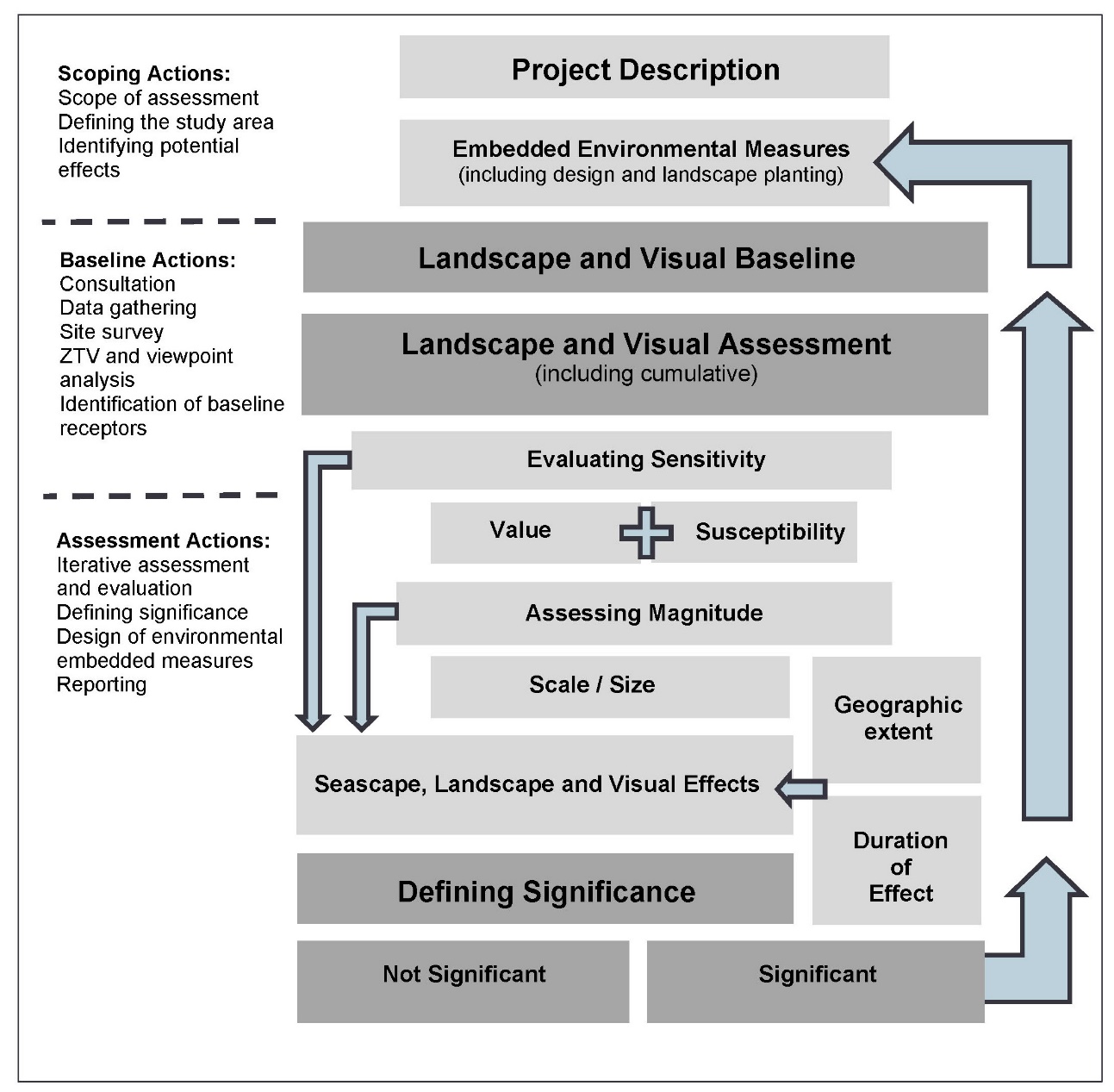
- An overview of the SLVIA process is provided here and illustrated, diagrammatically in Table 15.15 Open ▸ .
Table 15.15: Overview of approach to SLVIA
- The SLVIA assesses the likely effects that the construction, operation and decommissioning of the Proposed Development on the seascape, landscape and visual resource, encompassing effects on seascape/landscape character, designated landscapes, visual effects and cumulative effects.
- An appropriate and proportionate level of assessment has been undertaken and agreed through consultation at the scoping stage. The level of assessment may be ‘preliminary’ (requiring desk-based data analysis) or ‘detailed’ (requiring site surveys and investigations in addition to desk-based analysis).
- For those matters ‘scoped in’ for assessment ( Table 15.13 Open ▸ ), the approach to level of assessment is tiered. A ‘preliminary’ or ‘detailed’ assessment is undertaken as follows:
- a ‘preliminary assessment’ approach for an environmental aspect / effect which may include secondary baseline data collection (for example desk-based information) and qualitative assessment methodologies. Preliminary assessments are set out in Table 15.19 Open ▸ (Representative Viewpoints) Table 15.20 Open ▸ (visual receptors) and Table 15.26 Open ▸ . The preliminary assessment identifies which seascape, landscape and visual receptors are unlikely to be significantly affected, which are subject to a preliminary assessment, and those receptors that are more likely to be significantly affected by the Proposed Development, which require a ‘detailed assessment’; and
- a ‘detailed assessment’ approach is undertaken for seascape, landscape and visual receptors/effects that are identified in the preliminary assessment as requiring detailed assessment, based on evaluation of receptor sensitivity, likely magnitude of change and geographic extent of effects, with reference to the ZTV analysis (Figure 15.5 to Figure 15.13). This detailed assessment, presented in Section 15.11, may include primary baseline data collection (for example through site surveys), quantitative and qualitative assessment methodologies, and modelling such as ZTV analysis (Figure 15.5 to Figure 15.13) and wireline/photomontage visualisations (Figure 15.21 to Figure 15.75).
- The assessment of whether an effect has the potential to be of likely significance has been based upon review of existing evidence base, consideration of commitments made (embedded environmental measures), professional judgement, evaluation of sensitivity of the receptor and magnitude of change, and where relevant, recommended aspect specific methodologies and best practice.
- To ensure the provision of a proportionate EIA Report that is focused on likely significant effects, the assessment takes into account the considerable levels of existing environmental information available, extensive local geographical knowledge and understanding of the site and surroundings gained from site selection analysis and environmental surveys.
- The seascape, landscape and visual assessment unavoidably, involves a combination of quantitative and qualitative assessment and wherever possible a consensus of professional opinion has been sought through consultation, internal peer review, and the adoption of a systematic, impartial, and professional approach.
15.9.3. Impact Assessment Criteria
Defining impact significance
- The seascape, landscape and visual effects (and whether they are significant) is determined by an assessment of the 'sensitivity' of each receptor or group of receptors and the 'magnitude of change' that would result from the Proposed Development.
- The evaluation of sensitivity takes account of the value and susceptibility of the receptor to the Proposed Development. This is combined with an assessment of the magnitude of change which takes account of the size and scale of the proposed change. By combining assessments of sensitivity and magnitude of change, a level of seascape, landscape or visual effect can be evaluated and determined. The resulting level of effect is described in terms of whether it is significant or not significant, and the geographical extent, duration and the type of effect is described as either direct or indirect; temporary or permanent; reversible; cumulative; and beneficial, neutral or adverse.
Sensitivity
- The sensitivity of seascape, landscape and visual receptors is an expression of the combination of the judgements made about the value of that receptor and its susceptibility to the specific type of change or the development proposed. Landscape value is the ‘inherent’ component, which is independent of the development proposal, while the other component, susceptibility, is development specific.
- The value of a seascape, landscape or view receptor is a reflection of the value that society attaches to that seascape, landscape or view. There are a range of factors that are used to establish value but the presence of designations at national or local levels often reflects the level of value or importance they signify to society. The range of factors that can be considered when identifying landscape value include natural heritage, cultural heritage, landscape condition, associations, distinctiveness, recreational, perceptual (scenic), perceptual (wildness and tranquillity) and functional factors (Landscape Institute, 2021).
- The susceptibility of a seascape or landscape to change is a reflection of its ability to accommodate the changes that may occur as a result of the addition of the Proposed Development, based on its characteristics, robustness, scale, topography, openness/enclosure, perceptual qualities and the associations between the landscape/seascape receptor and the Proposed Development. The susceptibility of visual receptors (people) relates mainly to the activity of the viewer (residents, motorists, walkers etc); the experience of the viewer - the extent to which attention or interest may be focused on the view and visual amenity; and the visual relationship between the receptors and the Proposed Development which combine to influence how susceptible viewers are to the potential effects of the Proposed Development.
- An overall assessment of the sensitivity of each seascape, landscape and visual receptor has been made by combining the assessment of the value of the receptor and its susceptibility to change. In SLVIA, sensitivity is specific to the Proposed Development and to the location in question. An overall level of sensitivity has been applied for each visual receptor or view – high, medium-high, medium, medium-low or low. These levels are not defined as such, however the basis for sensitivity assessments has been made clear using evidence and professional judgement in the evaluation of each receptor, with reference to criteria that tend towards higher or lower sensitivity levels as set out in Technical Appendix 15.1: SLVIA Methodology.
Magnitude
- The magnitude of change affecting seascape, landscape and visual receptors is an expression of the scale of the change that will result from the Proposed Development and is dependent on a number of variables regarding the size or scale of the change that will arise as a result of the Proposed Development. The geographic extent over which the change will be experienced is also assessed, which is distinct from the size or scale of change. The criteria for defining magnitude in this chapter are outlined in Table 15.16 Open ▸ below.
Table 15.16: Definition of Terms Relating to the Magnitude of an Impact
Significance of Effect
- Information about the Proposed Development and the proposed activities with all stages of the Proposed Development life cycle (construction, operation and maintenance, and decommissioning) is combined with information about the environmental baseline to identify the potential interactions between the Proposed Development and the environment.
- These potential interactions are known as potential impacts. The potential impacts are then assessed for the level of significance of their effect on the receiving environment/receptors.
- To ensure consistency across the team of Offshore EIA Report authors, the terms impact and effect are defined below. The definitions are based on the glossary of the Highways Agency Design Manual for Roads and Bridges (DMRB) (2008):
- Impact: Change that is caused by an action. Impacts can be defined as direct, indirect, temporary, irreversible, secondary, cumulative and inter-related. They can also be either positive or negative, although the relationship between them is not always straightforward; and
- Effect: Term used to express the consequence of an impact (expressed as the 'significance of effect'), which is determined by correlating the magnitude of the impact to the importance, or sensitivity, of the receptor or resource in accordance with defined significance criteria. For example, using the inter-array cable laying example again, the laying of an inter-array cable (action) results in seabed disturbance (impact), with the potential to disturb benthic habitats and species (effect).
- The outcome of the assessment is the determination of the significance of these effects against predetermined criteria.
- The process for determining the significance of effects is a two-stage process that involves defining the magnitude of the potential impacts and the sensitivity of the receptors. This section describes the criteria applied in this chapter to assign values to the magnitude of potential impacts and the sensitivity of the receptors. The terms used to define magnitude and sensitivity are based on those which are described in further detail in volume 1, chapter 6 of the Offshore EIA Report.
- The significance of the effect upon seascape, landscape and visual receptors is determined by correlating the magnitude of the impact and the sensitivity of the receptor. The particular method employed for this assessment is presented in Table 15.17 Open ▸ .
- The significance of the effect on each seascape/landscape character and visual receptor is dependent on all of the factors considered in the sensitivity of the receptor and the magnitude of change resulting from the Proposed Development. Factors which influence levels of sensitivity and magnitude of change assessed in the SLVIA are set out in full in Technical Appendix 15.1: SLVIA Methodology. Judgements on sensitivity and magnitude of change are combined to arrive at an overall assessment as to whether the Proposed Development will have an effect that is significant or not significant on each seascape/ landscape and visual receptor.
- The matrix in Table 15.17 Open ▸ is used as a guide to help inform the threshold of significance when combining sensitivity and magnitude to assess significance. On this basis potential impacts are assessed as of negligible, minor, moderate and major. In those instances where there would be no effect, the magnitude has been recorded as ‘Zero’ and the level of effect as ‘None’.
- For the purposes of this assessment, any effects with a significance level of major and major/moderate have been deemed significant in EIA terms (dark shaded boxed in Table 15.17 Open ▸ ). ‘Moderate’ levels of effect (indicated in grey in Table 15.17 Open ▸ ) have the potential, subject to the assessor’s professional judgement, to be considered as significant or not significant, depending on the sensitivity and magnitude of change factors evaluated. These assessments are explained as part of the assessment, where they occur.
- Significance can therefore occur at a range of levels depending on the magnitude and sensitivity, however in all cases, a significant effect is considered more likely to occur where a combination of the variables results in the Proposed Development having a defining effect on the landscape/seascape character or view. Definitions are not provided for the individual categories of significance shown in the matrix and the reader should refer to the detailed definitions provided for the factors that combine to inform sensitivity and magnitude. Effects assessed as being either moderate/minor, minor, minor/negligible or negligible level are assessed as non-significant (light shaded boxes in Table 15.17 Open ▸ ).
- In line with the emphasis placed in GLVIA3 upon the application of professional judgement, an overly mechanistic reliance upon a matrix is avoided through the provision of clear and accessible narrative explanations of the rationale underlying the assessment made for each landscape and visual receptor.
Table 15.17: Matrix Used for the Assessment of the Significance of the Effect
Geographical extent
- The geographic extent over which the seascape/landscape and visual effects will be experienced is also assessed, which is distinct from the size or scale of effect. This evaluation is not combined in the assessment of the level of magnitude, but instead expresses the extent of the receptor that will experience a particular magnitude of change and therefore the geographical extents of the significant and not significant effects. The geographic extent of the effects varies depending on the specific nature of the Proposed Development and is principally assessed through analysis of the extent of perceived changes through visibility of the Proposed Development using the ZTV (Figure 15.5 and Figure 15.6) and field survey verification.
Duration and reversibility
- The duration and reversibility of seascape, landscape and visual effects is based on the period over which the Proposed Development is likely to exist and the extent to which it will be removed and its effects reversed at the end of that period. OPEN’s methodology does not include duration and reversibility as part of magnitude of change, as there is potential that the reversibility aspect could alter or reduce potentially significant effects even though they are long-term. The duration and reversibility of the effects is instead determined separately in relation to the assessed effects.
- Long-term, medium-term and short-term seascape/ landscape effects are defined as follows:
- long-term – more than 10 years;
- medium-term – 6 to 10 years; and
- short-term – 1 to 5 years.
- Duration and reversibility are not incorporated into the assessment of magnitude of change, but are stated separately in relation to the assessed effects (i.e. as short/medium/long-term and temporary/permanent) and are considered as part of drawing conclusions about significance, combining with other judgements on sensitivity and magnitude, to allow a final judgement to be made on whether each effect is significant or not significant.
Visibility
- The varied clarity or otherwise of the atmosphere will reduce the number of days (the ‘frequency’) upon which views of the Proposed Development will be available from the coastline and hinterland, and is likely to inhibit clear views, rendering the Proposed Development wind turbines located at long distance offshore, as visually recessive within the wider seascape. The effects of the construction and operation of the offshore infrastructure will vary according to the weather and prevailing visibility. This means that effects that are may be significant in the SLVIA under ‘very good’ or ‘excellent’ (i.e., worst-case/optimum) visibility conditions, may be not significant under moderate, poor or very poor visibility conditions.
- Assessments are based on a worst-case position of optimum (‘very good’ or ‘excellent’) visibility, in line with current guidance (Landscape Institute and IEMA, 2013), however within the visual assessment there is an assessment of the frequency or ‘likelihood’ of effect’ for each viewpoint, based on the distance of the Proposed Development, Met Office visibility data and professional judgement based on experience of viewing offshore wind farms in different conditions and distances. Likely visibility frequency can therefore been taken into consideration, with visibility range from viewpoints located at very long distances over 40km (where ‘excellent’ visibility is required) occurring less frequently than viewpoints at closer range.
View Range
- In assessing the visual effects of the Proposed Development, the distance between the Proposed Development and the relevant visual receptor is described as being short-range, mid-range, long range or very long range, which are defined as follows:
- very long range - over 40 km;
- long range – 25 to 40 km;
- mid-range – 15 to 25 km; and
- short range – 0 to 15 km.
15.9.4. Visual Representations Methodology
- The methodology for the production of visual representations (photomontages and ZTVs) of the Proposed Development is set out in full in Technical Appendix 15.1: SLVIA Methodology.
- The visual representations presented in Figure 15.21 to Figure 15.75, have been produced in accordance with Visual Representation of Wind farms (NatureScot, 2017) and Visual Representation of Development Proposals (TGN 06/19) (Landscape Institute, 2019).
- The ZTVs in Figure 15.5 to Figure 15.13 have also been produced in line with guidance in Visual Representation of Wind farms (NatureScot, 2017) and are generated using GIS software (ESRI ArcGIS Version 10.5) to model the theoretical visibility of the Proposed Development.
- ZTVs and visual representations are produced on the assumption that the Proposed Development wind turbines are modelled relative to Lowest Astronomical Tide (LAT) sea level at their maximum blade tip height (355 m). The sea level for LAT is modelled at -2.27 m below Ordnance datum (OD), which is equivalent of LAT for the closest tidal station in Aberdeen. The height of LAT within the Proposed Development Array Area relative to mean sea level (MSL) is between -2.46 and -2.87 m.
- The photographs used in the photomontages shown in Figure 15.21 to Figure 15.75 were captured during October, November and December 2021; and January 2022 as described in Table 15.6 Open ▸ in excellent visibility conditions and show this maximum potential visibility of the Proposed Development. In reality the degree and extent of visual effects arising from the Proposed Development will be influenced by the prevailing weather and visibility conditions and such excellent visibility occurs relatively infrequently, as described in Section 15.7.2.
15.10. Measures Adopted as part of the Proposed Development
15.10. Measures Adopted as part of the Proposed Development
- As part of the project design process, a number of measures have been proposed to reduce the potential for impacts on seascape, landscape and visual receptors (see Table 15.18 Open ▸ ). As there is a commitment to implementing these measures, they are considered inherently part of the design of the Proposed Development and have therefore been considered in the assessment presented in Section 15.11 below (i.e. the determination of magnitude and therefore significance assumes implementation of these measures). These measures are considered standard industry practice for this type of development.
Table 15.18: Designed In Measures Adopted as Part of the Proposed Development
- No secondary mitigation has been applied in response to seascape, landscape and visual receptors, therefore all effects within the following assessment of significant in Section 15.11 are assessed as residual effects.
15.11. Assessment of Significance
15.11. Assessment of Significance
Effects (daytime) of the construction and decommissioning of the offshore ELEMENTS ON visual receptors/views
- The Proposed Development will have impacts on visual receptors/views during construction and decommissioning phases (as indicated in Table 15.13 Open ▸ ).
- Construction and decommissioning phase effects on visual amenity will occur as a result of the activities, including laying offshore export cables to shore; installation of wind turbines and OSPs; use of service vessels and partially constructed/decommissioned offshore elements, all of which may combine to alter the visual amenity through visibility of the construction and decommissioning activities.
- The residual effects arising as a result of the construction and decommissioning of the Proposed Development are assessed as being of the same or lower magnitude and significance on all visual receptors and viewpoints as those arising due to their operation and maintenance, however the residual effects are assessed as being short-term and temporary, occurring during the length of the construction and decommissioning phase, and differing in nature from the operational effects mainly due to the influence of the various construction vessels in the seascape, including cable laying vessels closer to shore within the export cable array area corridor, that will not be present or result in effects during the operational phase. During the majority of the construction and decommissioning phases the magnitude of change and effects on visual receptors/views will be less than during the operational phase, while the wind turbines are not fully constructed.
Effects (daytime) of the construction and decommissioning of the offshore elements of the Proposed Development on seascape (COASTAL) character
- The Proposed Development will have impacts on perceived seascape character during construction and decommissioning phases (as indicated in Table 15.13 Open ▸ ).
- Construction and decommissioning phase effects on seascape (coastal) character will occur as a result of the construction activities, including laying new offshore export cables to shore; the construction phase for the installation of and wind turbines; windfarm service vessels and partially constructed offshore elements; all of which may combine to alter the visual amenity and seascape character through visibility of the construction and decommissioning activities.
- The residual effects arising as a result of the construction and decommissioning of the Proposed Development are assessed as being of the same magnitude and significance on all seascape receptors as those arising due to their operation and maintenance, with the residual effects being short-term and temporary, occurring during the length of the construction and decommissioning phase and differing in nature from the operational effects mainly due the influence of the various construction vessels in the seascape, including cable laying vessels closer to shore within the export cable array area corridor, that will not be present or result in effects during the operational phase. During the majority of the construction and decommissioning phases the magnitude of change and effects on coastal character will be less than during the operational phase, while the wind turbines are not fully constructed.
Effects (daytime) of the construction and decommissioning of the offshore elements of the Proposed Development on perceived landscape character/special qualities of designated landscapes
- The Proposed Development will have impacts on perceived landscape character/special qualities during construction and decommissioning phases (as indicated in Table 15.13 Open ▸ ).
- Construction and decommissioning phase effects on perceived landscape character will occur as a result of the construction activities, including laying new offshore export cables to shore; the construction phase for the installation of wind turbines; windfarm service vessels; and partially constructed offshore elements; all of which may combine to alter the perceived landscape character through visibility of the construction and decommissioning activities.
- The residual effects arising as a result of the construction and decommissioning of the Proposed Development are assessed as being of the same magnitude and significance on all landscape receptors as those arising due to their operation and maintenance, with the residual effects being short-term and temporary, occurring during the length of the construction and decommissioning phase and differing in nature from the operational effects mainly due the influence of the various construction vessels in the seascape, including cable laying vessels closer to shore within the export cable array area corridor, that will not be present or result in effects during the operational phase. During the majority of the construction and decommissioning phases the magnitude of change and effects will be less than during the operational phase, while the wind turbines are not fully constructed.
- The Proposed Development will have impacts on visual receptors/views during the operation and maintenance phase (as indicated in Table 15.13 Open ▸ ).
15.11.1. Preliminary Assessment of Viewpoints and Visual Receptors
- A preliminary assessment of the effects of the operation and maintenance of the Proposed Development on representative viewpoints in the Seascape study area is presented in Table 15.19 Open ▸ . A detailed assessment follows in Section 15.11.2 for each viewpoint that is identified in the preliminary assessment as requiring detailed assessment.
Table 15.19: Preliminary Assessment Representative Viewpoints
- A preliminary assessment of the effects of the operation and maintenance of the Proposed Development on the visual receptors in the Seascape study area is presented in Table 15.20 Open ▸ with reference to the ZTV analysis in Figure 15.5 to Figure 15.13 A detailed assessment follows in Section 15.11.3 for each visual receptor that is identified in the preliminary assessment as requiring detailed assessment.
Table 15.20: Preliminary Assessment Visual Receptors
15.11.2. Detailed Assessment of Daytime Effects on Views
Viewpoint 1 Johnshaven (NCN1)
Baseline and sensitivity
- The location and baseline panorama from Viewpoint 1 Johnshaven (NCN1) are shown in Figure 15.21a-d and a baseline 53.5° HFoV photomontage including Seagreen 1 offshore wind farm is shown in Figure 15.21e.
- Located on the Cove Bay to Milton Ness coastline (SA 3), the viewpoint lies on Fore Street, just behind the shoreline with residential development within Johnshaven behind. The view looking south-east towards the Proposed Development looks over the open North Sea to the sea horizon and is wide and long-ranging. Looking south-west, the view is enclosed by the sweeping sandy beach of Montrose Bay (SA 4); the low hills of Montreathmoor and Rossie covered by a patchwork of farm and woodland behind; Scurdie Ness lighthouse and Red Head’s rugged cliffs jutting beyond the headland of Long Craig (SA 5); and the Angus coastline between Lang Craig to Deil’s Heid (SA 7) in the distance. Johnshaven lies on a convex curve of the coastline, and its buildings enclose the view north and prevail on the coastal edge to the south. Seagreen 1 offshore wind farm is visible in the view out to sea approximately 28.1 km to the south-east, occupying 33° of the horizontal field of view and forming the main scale comparators at sea, however Neart na Gaoithe offshore wind farm is barely visible at 51.7 km.
- The sensitivity of the viewpoint is considered to be medium-high, reflecting that the view has medium-high value and the receptors experiencing the view have a medium-high susceptibility to change, for the reasons set out below.
- Value. The viewpoint is a locally valued area to enjoy the sea with view benches orientated to overlook the sea. The view is not afforded protection in planning policy, but encompasses ‘rugged and intricate scenery’ that is characteristic of the South East Aberdeenshire Coast SLA and afforded planning policy protection. Not recognised informally or known as having particular scenic qualities, the expansive view is largely representative of views from this section of coast, is simple in composition and otherwise has few specific elements or a composition from which scenic value may be derived.
- Susceptibility. The village is located within Raised Beach Coast (LCT 13), and characteristically, climbs the slope to the A92 from the shoreline and Fore Street, where the viewpoint is located. The view is representative of the view experienced by residents of the village who gain static, long duration views, often out to sea due to the coastward orientation of the village; and people using NCN1, who gain dynamic but protracted views along the southern Aberdeenshire coastline as they travel along the coastal section of the route between Inverbervie and Johnshaven, avoiding the A92. The viewpoint affords a direct view out to sea from the coastal edge, in which viewers are more liable to be influenced by development in the sea. The wide view of the sea horizon is the primary focus despite enclosure to the south-west by the sweeping Angus coastline. The offshore site boundary is remote and separated by the open seas from the viewpoint. The visual amenity experienced by the viewers is already influenced by the presence of the Seagreen 1 wind turbines as visible elements experienced in the view of the sea, which moderates the viewers susceptibility to change.
Magnitude of change
- The predicted view of the Proposed Development from Viewpoint 1 Johnshaven (NCN1) is shown in the photomontage in Figure 15.21g. The magnitude of change to the view resulting from the operation and maintenance of the Proposed Development is assessed as low, for the reasons set out below.
- The Proposed Development array area will be located a long distance, between (approximately) 48.5 km and 95.9 km offshore from the viewpoint to its closest and most distant points. At such long distances, the Proposed Development wind turbines will be in the far distance on the distant seascape skyline, beyond a broad swathe of seascape.
- The upper towers and rotors of 144 wind turbines may be visible above the skyline, with the lower parts of the towers and semi-submersible platforms hidden by the intervening horizon. The rotor blades are likely to appear oblique/side on to the viewer when operating during the prevailing south-westerly wind direction. The more distant wind turbines in the array will be substantially less visible, ensuring that the Proposed Development appears less dense overall.
- The vertical height/apparent scale of the Proposed Development wind turbines will be relatively small, due to their long distance offshore and the large scale of the seascape in the view. The vertical appearance of the wind turbines may contrast with the horizontal emphasis of the sea skyline, but the wind turbines will appear no greater in vertical scale than the coastal landform to the south-west and of similar vertical scale to Seagreen 1.
- The lateral spread of the Proposed Development wind turbines may occupy up to 28° of the horizontal field of view (HFoV) but will appear subsumed behind and overlapping much of Seagreen 1 to the north, therefore only adding a further 12° to the HFoV - a narrow portion of the view, in which much of the open sea skyline will be retained and the coastline views unaffected. Where the Proposed Development and Seagreen 1 overlap, the combined array may appear denser.
- The Proposed Development wind turbines may generally be seen beyond the horizon, viewed as a ‘horizon development’ beyond a large open seascape, rather than being viewed ‘within’ its seascape, clearly separated from the mainland coast, and headlands intervening seascape. The Proposed Development wind turbines are sufficiently distant, small scale and narrow in lateral extent, that the panoramic views to the sea either side will be retained. The majority of the Proposed Development wind turbines may be seen as blade tip only, with the closest rotors visible above horizon. The ‘rugged and intricate scenery of weathered coastal cliffs and raised beach landforms’ providing the setting to Johnshaven, and current levels of visual amenity will remain largely unchanged.
Significance of Effect in EIA terms
- Based on the combination of the medium-high sensitivity of the viewpoint and low magnitude of change, the significance of effect arising from the Proposed Development is assessed as not significant (moderate/minor), direct, long-term and reversible.
- Excellent visibility will be required for the closest Proposed Development wind turbines to be visible at distances over 48.5 km from the viewpoint. The likelihood of the effect occurring is considered to be of low frequency. Met Office visibility data indicates only 10.7% visibility frequency of the Proposed Development at distances of 50-60 km and 0% visibility frequency at distances over 60 km (the Met Office data has no records of visibility greater than 60 km). The more distant wind turbines in the array are unlikely to be visible, ensuring that the Proposed Development has less effect overall. The closest Proposed Development wind turbines are likely to be intermittently and infrequently visible due to the prevailing weather conditions, which will often prevent visibility of such distant objects at such long-range. Even during excellent visibility periods, the wind turbines will still likely be viewed as being recessive, due to the low contrast with the sky, atmospheric conditions out to sea and the visual acuity of the eye to distinguish wind turbines at such long distances.
Viewpoint 2 Montrose
Baseline and sensitivity
- The location and baseline panorama from Viewpoint 2 Montrose are shown in Figure 15.22a-c and a baseline 53.5° HFoV photomontage including Seagreen 1 offshore wind farm is shown in Figure 15.22e.
- The viewpoint is located just behind the shoreline of Montrose Bay (SA4) within Beaches, Dunes and Links (LCT 388). The view looks south-east over the seascape of Montrose Bay from parking at the Montrose Beach facilities on Traill Drive. The seascape in the view extends across a wide bay (Montrose Bay) partially enclosed to the north by the Aberdeenshire coastline between Cove Bay to Milton Ness (SA 3); and to the south by the low peninsula of Scurdie Ness within Long Craig (SA 5). The sweep of Montrose Bay’s sandy beach is backed by low hills falling to the sea at Milton Ness and settled areas within the majority of the ZTV are set slightly inland from the coast. The settled landscape is a mix of farm and woodland with a number of onshore wind turbines visible in the short-medium range on the landform backdrop northwards towards Aberdeenshire. The lighthouse at Scurdie Ness is forms a landmark and focus feature to the south-east. Seagreen 1 offshore wind farm is visible in the view out to sea approximately 31.8 km to the east/south-east, occupying 29° of the horizontal field of view and forming the main scale comparators at sea, however Neart na Gaoithe offshore wind farm is not visible.
- The sensitivity of the viewpoint is considered to be medium, reflecting that the view has medium value and the receptors experiencing the view have a medium susceptibility to change, for the reasons set out below.
- Value. The viewpoint is located at a locally valued area to enjoy views of the sea, at a recreational facility behind Montrose Beach. Car parking, toilets and other facilities are located here with benches orientated to overlook the sea. The view is not afforded protection in planning policy and neither lies within, nor does it generally overlook a designated landscape, although the coast to the north is locally designated. Not recognised informally or known as having particular scenic qualities, the expansive view is largely representative of views from this section of coast, having few specific elements or a composition from which particular scenic value may be derived.
- Susceptibility. The viewpoint is representative of people on the beach or utilising the recreational facilities behind, for whom the view is integral to their experience. The viewpoint affords a direct view out to sea from the coastal edge, in which viewers are more liable to be influenced by development in the sea, and receptors are likely to be either slow moving or stationary. The view of the wide bay is part of the primary interest in the view along with focal points such as the lighthouse at Scurdie Ness and the interface of land and coast. The offshore site boundary is remote and separated by open sea from the viewpoint location. The visual amenity experienced by the viewers is already influenced by the presence of the Seagreen 1 wind turbines as visible elements experienced in the view of the sea, which moderates the viewers susceptibility to change.
Magnitude of change
- The predicted view of the Proposed Development from Viewpoint 2 Montrose is shown in the photomontage in Figure 15.22f. The magnitude of change to the view resulting from the operation and maintenance of the Proposed Development is assessed as medium-low, for the reasons set out below.
- The Proposed Development array area will be located at long distance, between (approximately) 45.3 km and 94.5 km offshore from the viewpoint to its closest and most distant points. At such long distances, the Proposed Development wind turbines will be in the far distance on the distant seascape skyline, beyond the immediate seascape context. The Proposed Development wind turbines may be seen on and beyond the horizon, being distant and low on the horizon.
- The upper towers and rotors of 133 wind turbines may be visible above the skyline, with the lower parts of the towers and semi-submersible platforms hidden by the intervening horizon. The rotor blades are likely to appear oblique/side on to the viewer when operating during the prevailing south-westerly wind direction. The more distant wind turbines in the array will be substantially less visible, ensuring that the Proposed Development appears less dense overall.
- The vertical height/apparent scale of the Proposed Development wind turbines will be relatively small, due to their long distance offshore and the large scale of the seascape in the view. The vertical appearance of the wind turbines may contrast with the horizontal emphasis of the sea skyline and the closest may appear slightly larger than those of Seagreen 1. The wind turbines of both developments will be smaller in vertical scale than the coastal landform of Scurdie Ness and the Aberdeenshire coast. Neart na Gaoithe offshore windfarm will be screened by Scurdie Ness.
- The lateral spread of the Proposed Development wind turbines may occupy up to 28° of the HFoV but will appear partially subsumed behind and overlapping some of Seagreen 1 to the north, therefore only adding a further 20° to the HFoV - a narrow portion of the view, in which much of the open sea skyline will be retained and the coastline views unaffected. The combined extent of both windfarms may appear contiguous with the Scurdie Ness headland, further enclosing the view to the south of the wide bay yet retaining open, unaffected seascape to the north of Seagreen 1.
Significance of Effect in EIA terms
- Based on the combination of the medium sensitivity of the viewpoint and medium-low magnitude of change, the significance of effect arising from the Proposed Development is assessed as not significant (moderate/minor), direct, long-term and reversible. The simple seascape will continue to be the predominant characteristic of the view.
- Excellent visibility will be required for the closest Proposed Development wind turbines to be visible at distances over 45.3 km from the viewpoint. The likelihood of the effect occurring is considered to be of relatively low frequency. Met Office visibility data indicates only 20.2% visibility frequency of the Proposed Development at distances of 45-60 km and 0% visibility frequency at distances over 60 km (the Met Office data has no records of visibility greater than 60 km). The more distant wind turbines in the array are unlikely to be visible, ensuring that the Proposed Development has less effect overall. The closest Proposed Development wind turbines are likely to be intermittently and infrequently visible due to the prevailing weather conditions, which will often prevent visibility of such distant objects at such long-range. Even during excellent visibility periods, the wind turbines will still likely be viewed as being recessive, due to the low contrast with the sky, atmospheric conditions out to sea and the visual acuity of the eye to distinguish wind turbines at such long distances.
Viewpoint 3 St Andrews Cathedral
Baseline and sensitivity
- The location and baseline panorama from Viewpoint 3 St Andrews Cathedral are shown in Figure 15.23a-c and a baseline 53.5° HFoV photomontage including Neart na Gaoithe offshore wind farm is shown in Figure 15.23e.
- The viewpoint is located on the clifftop by the cemetery of the ruined St Andrews Cathedral. Looking just south of east, the view of the open sea is wide, yet the seascape in the view is partially enclosed beyond the foreground of stone harbour and pier, by the rocky coastline (SA 12) to the south extending into successive low headlands at Kinkell Ness, Buddo Ness and Babett Ness, and to the north by the Angus coastline beyond the Forth of Tay. In the view to the east, towards the Proposed Development, steep scrub covered slopes rising from the shoreline abruptly turn into level farmland above containing several large buildings and buildings within St Andrews can be seen in the foreground.
- To the north, the ruined St Andrews castle is prominent above the rocky coastline (SA 12) against a backdrop of successive layers of landscape: the sandy coastline of St Andrews Bay (SA 11) including West Sands and Tentsmuir Sands, with the extensive Tentsmuir forest forming a long, dark line above; the low hills of north eastern Fife; the settled landscape of Angus, slowly falling to the sea; and beyond, the low skyline of the Sidlaw Hills. Behind the sandy Angus shoreline (SA 8), the landscape is covered by farm and woodland, settlement and occasional tall structures including the wind turbines at Michelin Tyre Factory in Dundee (17.3km away) and Low Lighthouse at Barry Links. Neart na Gaoithe offshore wind farm is visible in the view along the coast approximately 28.5 km to the east, occupying 20° of the horizontal field of view and forming the main scale comparators at sea, however Seagreen 1 offshore wind farm is barely visible at 56.4 km.
- The sensitivity of the viewpoint is considered to be medium-high, reflecting that the view has medium-high value and the receptors experiencing the view have a medium susceptibility to change, for the reasons set out below.
- Value. While not an OS mapped viewpoint, the viewpoint is a well-recognised viewpoint with benches oriented towards the sea to promote the enjoyment of the view. The view is not afforded protection in planning policy, and neither lies in nor overlooks a designated landscape when looking towards the Proposed Development, however parts of the coast to the north are locally designated. It is easily accessible from the surrounding settlement and a popular location for visitors and residents alike due to the presence of the cathedral, castle and the expansive view of the coastline. Much of the Fife coastline that is visible extending east in the view to Fife Ness is locally designated as part of the St Andrews to Fife Ness LLA.
- Susceptibility. The viewpoint affords a direct view out to the sea and is representative of the view experienced by people using the clifftop path, including those following the Fife Coastal Path who are likely to make a diversion around the cathedral to view the coastline. The interest of receptors is likely to be on both features such as the cathedral and cemetery in the foreground, as well as the seascape to the east, with the main susceptibility deriving from the potential introduction of elements into the focus of the open sea view. The viewpoint is less representative of views experienced by residents of St Andrews with housing areas generally set further back from the coastal edge than this viewpoint on the coastal path. The visual amenity experienced by the viewers is already influenced by the presence of the Neart na Gaoithe wind turbines as visible elements experienced in the view along the coast towards Fife Ness, which moderates the viewers susceptibility to change.
Magnitude of change
- The predicted view of the Proposed Development from Viewpoint 3 St Andrews Cathedral is shown in the photomontage in Figure 15.23f. The magnitude of change to the view resulting from the operation and maintenance of the Proposed Development is assessed as low, for the reasons set out below.
- The Proposed Development array area will be located at long distance, between (approximately) 52.9 km and 94.5 km offshore from the viewpoint to its closest and most distant points. At such long distances, the Proposed Development wind turbines will be in the far distance on the distant seascape skyline, beyond the immediate seascape context.
- The upper towers and rotors of 164 wind turbines may be visible above the skyline, with the lower parts of the towers and semi-submersible platforms hidden by the intervening horizon. The rotor blades are likely to be slightly oblique and not fully facing the viewer when operating during the prevailing south-westerly wind direction. The more distant wind turbines in the array will be substantially less visible, ensuring that the Proposed Development appears less dense overall.
- The vertical height/apparent scale of the Proposed Development wind turbines will be relatively small, due to their long distance offshore and the large scale of the seascape in the view. The vertical appearance of the wind turbines may contrast with the horizontal emphasis of the sea skyline, but the wind turbines will be smaller in vertical scale than the neighbouring wind turbines of Neart na Gaoithe, and the coastal landform south of the viewpoint. The Proposed Development will introduce additional offshore wind turbine elements that extends the lateral extent of such development at Neart na Gaoithe in the view.
- The lateral spread of the Proposed Development wind turbines may occupy up to 27° of the HFoV but will appear subsumed behind and overlapping much of Neart na Gaoithe to the south, therefore only adding a further 13° to the HFoV - a narrow portion of the view, in which the majority of the open sea skyline to the north will be retained and the coastline views unaffected. Where the Proposed Development and Neart na Gaoithe overlap, the combined array will appear denser.
- The Neart na Gaoithe and Proposed Development wind turbines will be seen on and beyond the horizon. The combined extent of both windfarms will appear contiguous with the headland at Fife Ness, further enclosing the view to the south yet retaining open, unaffected seascape to the north of the Proposed Development. The Proposed Development wind turbines are sufficiently distant and similar to those of Neart na Gaoithe that the ‘expansive seaward views’ of the ‘rugged coastal edge’ will remain. The simplicity and composition of the seascape will be retained and will continue to be definitive.
Significance of Effect in EIA terms
- Based on the combination of the medium-high sensitivity of the viewpoint and low magnitude of change, the significance of effect arising from the Proposed Development is assessed as not significant (moderate/minor), direct, long-term and reversible.
- Excellent visibility will be required for the closest Proposed Development wind turbines to be visible at distances over 52.9 km from the viewpoint. The likelihood of the effect occurring is considered to be of low frequency. Met Office visibility data indicates only 10.7% visibility frequency of the Proposed Development at distances of 50-60 km and 0% visibility frequency at distances over 60 km (the Met Office data has no records of visibility greater than 60 km). The more distant wind turbines in the array are unlikely to be visible, ensuring that the Proposed Development has less effect overall. The closest Proposed Development wind turbines are likely to be intermittently and infrequently visible due to the prevailing weather conditions, which will often prevent visibility of such distant objects at such long-range. Even during excellent visibility periods, the wind turbines will still likely be viewed as being recessive, due to the low contrast with the sky, atmospheric conditions out to sea and the visual acuity of the eye to distinguish wind turbines at such long distances.
Viewpoint 4 Cambo Sands
Baseline and sensitivity
- The location and baseline panorama from Viewpoint 4 Cambo Sands are shown in Figure 15.24a-c and a baseline 53.5° HFoV photomontage including Neart na Gaoithe offshore wind farm is shown in Figure 15.24e.
- The viewpoint is located at the carpark associated with the popular beach on the St Andrews to Fife Ness coast (SA 12) adjoining Coastal Terraces (LCT 193). The view of the sea is expansive and long-range with the shallow slope of the low lying coastline emphasising the sea’s expanse and some containment provided by the coastlines extending north to Angus and south to Fife Ness. The sandy coastline extends northwards to Babett Ness with the mouth of the Tay behind, seen against a backdrop of the Angus coast and Sidlaw Hills inland. The Angus and distant Aberdeen coast encloses much of the view north. To the south, the sandy Fife coastline continues to Fife Ness, the low landform curtailing the view beyond. The Fife Coast Path runs behind the shoreline on this section of coast. A number of onshore wind farms are theoretically visible at long distance to the north on the inland backdrop but have limited influence on the view at such long range. Neart na Gaoithe offshore wind farm is visible in the view out to sea approximately 19.4 km to the east, occupying 30° of the horizontal field of view and forming the main scale comparators at sea, however Seagreen 1 offshore wind farm is barely visible at 50.4 km.
- The sensitivity of the viewpoint is considered to be medium-high, reflecting that the view has medium-high value and the receptors experiencing the view have a medium-high susceptibility to change, for the reasons set out below.
- Value. Facilities at the popular beach include car parking, toilets, picnic area, kiosk and benches orientated towards the sea. The area is a valued location to enjoy sea views but not afforded protection in planning policy. The viewpoint is located within the St Andrews to Fife Ness LLA and takes in its coastline, to the north and south. Scenic quality derives from the relative naturalness of the coastline, the visible expanse of sea and the sandy Fife coastline with the Tay and Angus coast behind.
- Susceptibility. The viewpoint is representative of people on the beach or the Fife Coast Path, who will appreciate the northern Fife coastline. The viewpoint affords a direct view out to sea from the coastal edge, in which viewers are more liable to be influenced by development in the sea. The presence of Seagreen 1 and Neart na Gaoithe offshore windfarms lowers the susceptibility. The visual amenity experienced by the viewers is already influenced by the presence of the Neart na Gaoithe wind turbines as visible elements experienced in the view of the sea, which moderates the viewers susceptibility to change.
Magnitude of change
- The predicted view of the Proposed Development from Viewpoint 4 Cambo Sands is shown in the photomontage in Figure 15.24f. The magnitude of change to the view resulting from the operation and maintenance of the Proposed Development is assessed as low, for the reasons set out below.
- The Proposed Development array area will be located at long distance, between (approximately) 44.8 km and 85.2 km offshore from the viewpoint to its closest and most distant points. At such long distance, the Proposed Development wind turbines will be in the far distance on the distant seascape skyline, beyond the immediate seascape context.
- The upper towers and rotors of 179 wind turbines may be visible above the skyline, with the lower parts of the towers and semi-submersible platforms hidden by the intervening horizon. The rotor blades are likely to be slightly oblique and not fully facing the viewer when operating during the prevailing south-westerly wind direction. The more distant wind turbines in the array will be substantially less visible, ensuring that the Proposed Development appears less dense overall.
- The vertical height/apparent scale of the Proposed Development wind turbines will be relatively small, due to their long distance offshore and the large scale of the seascape in the view. The vertical appearance of the wind turbines may contrast with the horizontal emphasis of the sea skyline, but the new offshore wind turbines will be noticeably smaller in vertical scale than similar and closer range wind turbines at Neart na Gaoithe. The Proposed Development will largely appear behind Neart na Gaoithe and will extend into the distance further offshore.
- The lateral spread of the Proposed Development wind turbines may occupy up to 31° of the HFoV but will appear subsumed behind and overlapping much of Neart na Gaoithe to the south, therefore only adding a further 8° to the HFoV - a narrow portion of the view, in which the majority of the open sea skyline to the north will be retained and the coastline views unaffected. Where the Proposed Development and Neart na Gaoithe overlap, the combined array will appear denser.
- The Proposed Development wind turbines will be seen on and beyond the horizon, viewed as a ‘horizon development’ beyond a large open seascape, clearly separated from the coast, rather than being viewed ‘within’ its seascape. The Proposed Development is visually separate from the headland at Fife Ness, and retains open, unaffected seascape to the north of the Proposed Development. The Proposed Development wind turbines are sufficiently distant and largely concentrated behind Neart na Gaoithe that the ‘expansive seaward views’ of the ‘rugged coastal edge’ will remain. The simplicity and composition of the seascape will be retained and will continue to be definitive.
Significance of Effect in EIA terms
- Based on the combination of the medium-high sensitivity of the viewpoint and low magnitude of change, the significance of effect arising from the Proposed Development is assessed as not significant (moderate/minor), direct, long-term and reversible.
- The Proposed Development wind turbines are likely to be intermittently and infrequently visible, having low contrast with the sky at such long-range and during the majority of prevailing visibility conditions. Met Office visibility data indicates only 20.2% visibility frequency of the wind turbines at 45 km and 10.7% at 50 km.
- Even during these ‘maximum’ visibility periods, the wind turbines will still likely be viewed as being recessive, due to the low contrast and visual acuity of the eye to distinguish shapes and details of wind turbines at such distance.
Viewpoint 5 Fife Ness
Baseline and sensitivity
- The location and baseline panorama from Viewpoint 5 Fife Ness are shown in Figure 15.25a-d and a baseline 53.5° HFoV photomontage including Neart na Gaoithe offshore wind farm is shown in Figure 15.25f.
- The viewpoint is located on the easternmost tip of the East Neuk of Fife coast, behind the shoreline of the rocky, settled coastline (SA 12) adjoining Coastal Terraces (LCT 193). The Fife Coast Path follows the shoreline on this section of coast. Encompassed by open sea, the viewpoint affords an expansive and long-range view out to sea, which is partially interrupted by the presence of Neart na Gaoithe offshore wind farm on the sea skyline at relatively short to medium range from the viewpoint. Neart na Gaoithe offshore wind farm is visible in the view out to sea approximately 15.6 km to the east, occupying 36° of the horizontal field of view and forming the main scale comparators at sea, however Seagreen 1 offshore wind farm is barely visible at 48.6 km. A number of onshore wind farms are theoretically visible at long distance to the north on the inland backdrop but have limited influence on the view at such long range.
- The sensitivity of the viewpoint is considered to be medium-high, reflecting that the view has medium-high value and the receptors experiencing the view have a medium-high susceptibility to change, for the reasons set out below.
- Value. There are no facilities provided for enjoyment of the sea view but the aspect of nearby properties reflects the value of the view for local residents. The view is not afforded protection in planning policy but is representative of the special qualities of the locally designated St Andrews to Fife Ness LLA wherein the viewpoint lies, which are afforded planning policy protection. These qualities include a perceived exposure and sense of remoteness gained from the this most easterly point of Fife and its exposure to the sea and wind. The visible coastline extending in both directions of the view is within St Andrews to Fife Ness LLA.
- Susceptibility. The viewpoint is representative of local residents and users of the Fife Coastal Path, who appreciate the coastal views. The viewpoint affords a direct view out to sea from the coastal edge and from this headland forming the most eastern and closest point of Fife to the Proposed Development, in which viewers are more liable to be influenced by development in the sea. The sea horizon and rugged coastal edge that is visually isolated from the coastal landscape inland is typical of the east coast area and provides a particular character of some scenic quality to this landscape. Static caravans, nearby houses and a coastguard station with a mast detract from the natural quality of the shoreline. The visual amenity experienced by the viewers is already influenced by the presence of the Neart na Gaoithe wind turbines as visible elements experienced in the view of the sea, which moderates the viewers susceptibility to change.
Magnitude of change
- The predicted view of the Proposed Development from Viewpoint 5 Fife Ness is shown in the photomontage in Figure 15.24g. The magnitude of change to the view resulting from the operation and maintenance of the Proposed Development is assessed as low, for the reasons set out below.
- The Proposed Development array area will be located at long distance, between (approximately) 41.7 km and 81.1 km offshore from the viewpoint to its closest and most distant points. At such long distance, the Proposed Development wind turbines will be in the far distance on the distant seascape skyline, beyond the immediate seascape context.
- The upper towers and rotors of 173 wind turbines may be visible above the skyline, with the lower parts of the towers and semi-submersible platforms hidden by the intervening horizon. The rotor blades are likely to be slightly oblique and not fully facing the viewer when operating during the prevailing south-westerly wind direction. The more distant wind turbines in the array will be substantially less visible, ensuring that the Proposed Development appears less dense overall.
- The vertical height/apparent scale of the Proposed Development wind turbines will be relatively small, due to their long distance offshore and the large scale of the seascape in the view. The vertical appearance of the wind turbines may contrast with the horizontal emphasis of the sea skyline, but the new offshore wind turbines will be noticeably smaller in vertical scale than the Neart na Gaoithe wind turbines, which are closer to the viewpoint. The Proposed Development will appear almost entirely behind Neart na Gaoithe, located at greater distance offshore.
- The lateral spread of the Proposed Development wind turbines may occupy up to approximately 32° HFoV, however due to their closer location of Neart na Gaoithe to the viewpoint, its wider HFoV and the apparently greater vertical scale, Neart na Gaoithe will appear to encompass much of the Proposed Development. The Proposed Development will only add a further 4° to the HFoV - a very narrow portion of the wide panorama, in which much of the open sea skyline will be retained and the coastline views unaffected. Where the Proposed Development and Neart na Gaoithe overlap, the combined array will appear denser.
- The Proposed Development wind turbines will be seen behind Neart na Gaoithe on and beyond the horizon, viewed as a ‘horizon development’ to a large open seascape, clearly separated from the coast, rather than being viewed ‘within’ its seascape. The Proposed Development wind turbines will be sufficiently distant that the ‘expansive seaward views’ of the ‘rugged coastal edge’ that is ‘visually isolated from the coastal landscape inland’ will largely remain unchanged. The perceived simplicity and composition of the seascape will be retained and will continue to be definitive.
Significance of Effect in EIA terms
- Based on the combination of the medium-high sensitivity of the viewpoint and low magnitude of change, the significance of effect arising from the Proposed Development is assessed as not significant (moderate/minor), direct, long-term and reversible.
- Excellent visibility will be required for the closest Proposed Development wind turbines to be visible at distances over 41.7 km from the viewpoint. The likelihood of the effect occurring is considered to be of relatively low frequency. Met Office visibility data indicates only 28.6% visibility frequency of the Proposed Development at distances of 40-60 km and 0% visibility frequency at distances over 60 km (the Met Office data has no records of visibility greater than 60 km). The more distant wind turbines in the array are unlikely to be visible, ensuring that the Proposed Development has less effect overall. The closest Proposed Development wind turbines are likely to be intermittently and infrequently visible due to the prevailing weather conditions, which will often prevent visibility of such distant objects at such long-range. Even during excellent visibility periods, the wind turbines will still likely be viewed as being recessive, due to the low contrast with the sky, atmospheric conditions out to sea and the visual acuity of the eye to distinguish wind turbines at such long distances.
Viewpoint 6 Crail
Baseline and sensitivity
- The location and baseline panorama from Viewpoint 6 Crail are shown in Figure 15.26a-c and a baseline 53.5° HFoV photomontage including Neart na Gaoithe offshore wind farm is shown in Figure 15.26e.
- The viewpoint lies on the Fife Coastal Path near Orchard Braes on the southern edge of Crail, on the East Neuk of Fife coastline (SA 14) adjoining the Coastal Terraces (LCT 193). The view is enclosed by Crail and the Fife coastline to the north east; and to the south beyond the mouth of the Firth of Forth and the Isle of May, the low lying East Lothian Coast. The distinctive village of Crail lies on the low clifftop around a small bay, dropping down steeply to a historic stone harbour and sandy beach. Another small bay, Roome Harbour lies beyond with new residential development on the clifftop and a caravan park just behind the shoreline. The Fife Coast Path largely follows the coastline. The view extends out to sea across the bay and although wide, is partially enclosed by the rocky coastline to the north within the bay and by the coastline of East Lothian beyond the Firth of Forth to the south, within which the Isle of May forms a distinctive focal point. Neart na Gaoithe offshore wind farm is visible in the view out to sea approximately 18.5 km to the north-east, occupying 32° of the horizontal field of view and forming the main scale comparators at sea, however Seagreen 1 offshore wind farm is barely visible at 52.4 km. A number of onshore wind farms grouping are theoretically visible at long distance to the south on the upland backdrop of East Lothian/Scottish Borders (Crystal Rig/Aikengall and Drone Hill/Quixwood/Penmansheil) but have limited influence on the view at such long range.
- The sensitivity of the viewpoint is considered to be medium-high, reflecting that the view has medium-high value and the receptors experiencing the view have a medium-high susceptibility to change, for the reasons set out below.
- Value. The viewpoint is a location where views of the sea and the setting of Crail may be appreciated from the settlement’s coastal edge or the Fife Coastal Path. There are no facilities provided for appreciating the view. The view is not afforded protection in planning policy, but takes in the East Neuk LLA, whose special qualities are protected, when looking in either direction along the coast. While the expansive view to the sea horizon is typical of this coastline, the addition of the Isle of May and distant East Lothian coast adds particular interest. The historic character of Crail and its harbour is uncommon and is complemented by the relatively gentle and comfortable quality of the coastline.
- Susceptibility. The viewpoint is representative of the view experienced by visitors to and residents of the town as well as people using the Fife Coast Path, who gain dynamic but protracted views along the coastline of the East Neuk. The viewpoint affords a direct view out to sea from the coastal edge, in which viewers are more liable to be influenced by development in the sea. The nearby harbour and old town offer visual interest and texture to a view otherwise dominated by the simplicity of the sea horizon. The visual amenity experienced by the viewers is already influenced by the presence of the Neart na Gaoithe wind turbines as visible elements experienced in the view of the sea, which moderates the viewers susceptibility to change.
Magnitude of change
- The predicted view of the Proposed Development from Viewpoint 6 Crail is shown in the photomontage in Figure 15.26f. The magnitude of change to the view resulting from the operation and maintenance of the Proposed Development is assessed as low, for the reasons set out below.
- The Proposed Development array area will be located at long distance, between (approximately) 45 km and 83.5 km offshore from the viewpoint to its closest and most distant points. At such long distance, the Proposed Development wind turbines will be in the far distance on the distant seascape skyline, beyond the immediate seascape context.
- The upper towers and rotors of 179 wind turbines may be visible above the skyline, with the lower parts of the towers and semi-submersible platforms hidden by the intervening horizon. The rotor blades are likely to be slightly oblique and not fully facing the viewer when operating during the prevailing south-westerly wind direction. The more distant wind turbines in the array will be substantially less visible, ensuring that the Proposed Development appears less dense overall.
- The vertical height/apparent scale of the Proposed Development wind turbines will be relatively small, due to their long distance offshore and the large scale of the seascape in the view. The vertical appearance of the wind turbines may contrast with the horizontal emphasis of the sea skyline, but the wind turbines will be smaller in vertical scale than those of Neart na Gaoithe.
- The lateral spread of the Proposed Development wind turbines may occupy 31° of the HFoV but will appear subsumed behind and overlapping Neart na Gaoithe, only adding a further 1° to the HFoV - a very narrow portion of the view, in which the majority of the sea skyline to the north between Neart na Gaoithe and the coast will be retained and the wider sea views to the south unaffected. Where the Proposed Development and Neart na Gaoithe overlap, the combined array will appear denser.
- The Proposed Development wind turbines are sufficiently distant and largely concentrated behind Neart na Gaoithe that the ‘expansive seaward views’ of the ‘rugged coastal edge’ will remain. The simplicity and composition of the seascape will be retained and will continue to be definitive.
Significance of Effect in EIA terms
- Based on the combination of the medium-high sensitivity of the viewpoint and low magnitude of change, the significance of effect arising from the Proposed Development is assessed as not significant (moderate/minor), direct, long-term and reversible.
- Excellent visibility will be required for the closest Proposed Development wind turbines to be visible at distances over 45 km from the viewpoint. The likelihood of the effect occurring is considered to be of relatively low frequency. Met Office visibility data indicates only 20.2% visibility frequency of the Proposed Development at distances of 45-60 km and 0% visibility frequency at distances over 60 km (the Met Office data has no records of visibility greater than 60 km). The more distant wind turbines in the array are unlikely to be visible, ensuring that the Proposed Development has less effect overall. The closest Proposed Development wind turbines are likely to be intermittently and infrequently visible due to the prevailing weather conditions, which will often prevent visibility of such distant objects at such long-range. Even during excellent visibility periods, the wind turbines will still likely be viewed as being recessive, due to the low contrast with the sky, atmospheric conditions out to sea and the visual acuity of the eye to distinguish wind turbines at such long distances.
Viewpoint 7 North Berwick Law
Baseline and sensitivity
- The location and baseline panorama from Viewpoint 7 North Berwick Law are shown in Figure 15.27a-d, which includes Neart na Gaoithe offshore wind farm shown in the baseline panorama in Figure 15.27c.
- Adjoining the southern edge of North Berwick, North Berwick Law is an iconic landmark feature and a popular visitor attraction. The viewpoint is located on the summit of the law within Coastal Terraces (LCT 278). The John Muir Way passes by the law to the west, following the Eyebroughy to Torness Point coastline (SA 18) west from the town centre. The summit of North Berwick Law affords a panoramic view over North Berwick and the wider landscape and coastal setting, including the Firth of Forth, Bass Rock and the islands of Fidra, Lamb and Craigleith which form distinctive characteristics in the seascape context of the view. Tantallon Castle also forms a landmark focal feature in thew view along the coast. The wider view extends across the East Lothian plain to the Lammermuir Hills, where the large onshore wind farm grouping formed by Crystal Rig and Aikengall wind farms occupies part of the upland skyline. Neart na Gaoithe offshore wind farm is visible in the view out to sea behind Bass Rock, approximately 33.1 km to the north-east, occupying 21° of the horizontal field of view and forming the main scale comparators at sea, however Seagreen 1 offshore wind farm is unlikely to be visible at 71.6 km.
- The sensitivity of the viewpoint is considered to be high, reflecting that the view has high value and the receptors experiencing the view have a medium-high susceptibility to change, for the reasons set out below.
- Value. The viewpoint is a location where views of the sea and the setting of North Berwick may be appreciated from the elevated viewpoint. There are no facilities provided for appreciating the view, although a whalebone arch provides a framing device for visitors to the summit. The specific view is not afforded protection in planning policy but is representative of the panoramic views, including the coast and setting of North Berwick, that are a special quality of the locally designated North Berwick Law SLA afforded protection by planning policy. The views take in the Tantallon Coast, and Port Seton to North Berwick Coast SLAs, covering the East Lothian coastline immediately below the law; and the Isle of May and East Neuk LLAs covering the island and the Fife coastline beyond. Looking south east, the landscape includes Leuchie, Tyninghame, and Broxmouth Park GDLs. The expansive view from elevation is not typical of this coastline, due to the flat topography and low number of high points such as the law. The islands in the Forth, Isle of May, Bass Rock and distant East Lothian coast adds particular interest. Shipping activity in the firth and development along both of its shores detracts from the quality of the view.
- Susceptibility. The viewpoint is representative of the view experienced by visitors to the summit of the law, who visit specifically to experience the view, whose interest and attention will be focused on the panorama, from a static position at the summit over relatively short duration and generally limited to occasional visits. The viewpoint affords a direct view out to sea from an elevated point, in which viewers are more liable to be influenced by development in the sea. The view out to sea includes specific focal points, such as Bass Rock, yet is part of a wider panorama that includes other features of interest in the view. The Forth, its islands and the opposing coast are the primary focus, with the nearby town and harbour, and surrounding landscape offering much visual interest and texture to a large scale view including the sea horizon. The visual amenity experienced by the viewers is already influenced by the presence of the Neart na Gaoithe wind turbines as visible elements experienced in the view of the sea, which moderates the viewers susceptibility to change.
Magnitude of change
- The predicted view of the Proposed Development from Viewpoint 7 North Berwick Law is shown in the wireline in Figure 15.27c. The magnitude of change to the view resulting from the operation and maintenance of the Proposed Development is assessed as low, for the reasons set out below.
- The Proposed Development array area will be located at very long distance, between (approximately) 56 km and 91.8 km offshore from the viewpoint to its closest and most distant points. At such long distance, the Proposed Development wind turbines will be in the far distance on the distant seascape skyline, beyond the immediate seascape context.
- The upper towers and rotors of 179 wind turbines may be visible above the skyline, with the lower parts of the towers and semi-submersible platforms hidden by the intervening horizon. The sweep of the rotor blades are likely to be oriented to face the viewer when operating during the prevailing south-westerly wind direction. The more distant wind turbines in the array will be substantially less visible, ensuring that the Proposed Development appears less dense overall.
- Due to the elevation of the viewpoint, the vertical height/apparent scale of the Proposed Development wind turbines will be greater than at other viewpoints, but still relatively small, due to their long distance offshore and the larger scale of the seascape in the view. The vertical appearance of the wind turbines may contrast with the horizontal emphasis of the sea skyline, but the wind turbines will appear smaller in vertical scale than islands within the Firth of Forth, and hills inland of the nearby opposing coastlines. The Proposed Development will introduce new offshore wind turbine elements beyond those within Neart na Gaoithe offshore windfarm.
- The lateral spread of the Proposed Development wind turbines may occupy up to 29° of the horizontal field of view (HFoV) but will appear subsumed behind and overlapping much of Neart na Gaoithe to the north, therefore only adding a further 20° to the HFoV - a relatively narrow portion of the view, in which much of the open sea skyline will be retained and the coastline views unaffected. Where the Proposed Development and Neart na Gaoithe overlap, the combined array will appear denser.
- The Proposed Development wind turbines will generally be seen beyond the horizon, viewed as a ‘horizon development’ beyond a large open seascape, rather than being viewed ‘within’ its seascape, clearly separated from the mainland coast and headlands. The Proposed Development wind turbines are sufficiently distant, small scale and contained in lateral extent, that the panoramic views to the sea either side will be retained. When visible, the Proposed Development will extend across the horizon between Bass Rock and Tantallon Castle, contributing to an increase in the distant offshore wind turbine backdrop to Bass Rock, that has been established by Neart na Gaoithe.
Significance of Effect in EIA terms
- Based on the combination of the high sensitivity of the viewpoint and low magnitude of change, the significance of effect arising from the Proposed Development is assessed as not significant (moderate/minor), direct, long-term and reversible.
- Excellent visibility will be required for the closest Proposed Development wind turbines to be visible at distances over 56 km from the viewpoint. The likelihood of the effect occurring is considered to be of low frequency. Met Office visibility data indicates only 10.7% visibility frequency of the Proposed Development at distances of 50-60 km and 0% visibility frequency at distances over 60 km (the Met Office data has no records of visibility greater than 60 km). The more distant wind turbines in the array are unlikely to be visible, ensuring that the Proposed Development has less effect overall. The closest Proposed Development wind turbines are likely to be intermittently and infrequently visible due to the prevailing weather conditions, which will often prevent visibility of such distant objects at such long-range. Even during excellent visibility periods, the wind turbines will still likely be viewed as being recessive, due to the low contrast with the sky, atmospheric conditions out to sea and the visual acuity of the eye to distinguish wind turbines at such long distances.
Viewpoint 8 Tantallon Castle
Baseline and sensitivity
- The location and baseline panorama from Viewpoint 8 Tantallon Castle are shown in Figure 15.28a-d and a baseline 53.5° HFoV photomontage including Neart na Gaoithe offshore wind farm is shown in Figure 15.28f.
- The viewpoint lies on the Eyebroughy to Torness Point coastline (SA 18) adjoining Coastal Terraces (LCT 278), east of North Berwick. The view looks north-east to the outer Firth of Forth with Tantallon Castle in the foreground and Bass Rock offshore in the middle distance forming distinctive features that frame and contain the view out to the sea skyline. The rocky Gin Head encloses the view to the northwest with the relatively unspoilt landscape of the coast to the south-east. Neart na Gaoithe offshore wind farm is visible in the view out to sea approximately 29.4 km to the north-east, occupying 23° of the horizontal field of view and forming the main scale comparators at sea, however Seagreen 1 offshore wind farm is unlikely to be visible at 68.4 km. The wider view extends across the East Lothian plain to the Lammermuir Hills, where the large onshore wind farm grouping formed by Crystal Rig and Aikengall wind farms occupies part of the upland skyline.
- The sensitivity of the viewpoint is considered to be high, reflecting that the view has high value and the receptors experiencing the view have a medium-high susceptibility to change, for the reasons set out below.
- Value. The viewpoint is a location where views of the sea and the setting of the castle may be appreciated from the castle grounds or the John Muir Way. The specific view is not afforded protection in planning policy but is representative of the special qualities of the locally designated Tantallon Coast SLA, which are afforded planning policy protection. While the expansive view to the sea horizon is typical of this coastline, the addition of the castle in the foreground and Bass Rock beyond is particularly distinctive to this location and often photographed or depicted within visual artworks. The combination of the castle and Bass Rock is unique along the southern shore of the Forth and is complemented by the relatively natural quality and comfortable scale of the coastline.
- Susceptibility. The viewpoint is representative of the view experienced by visitors to the castle and/or its grounds, and users of the John Muir Way. The viewpoint affords a direct view out to sea from the coastal edge, in which viewers are more liable to be influenced by development in the sea. The castle and Bass Rock are the principal attractors within a view otherwise characterised by the simplicity of the sea horizon, with shipping activity within the Forth, and the Neart na Gaoithe offshore windfarm on the horizon. The visual amenity experienced by the viewers is already influenced by the presence of the Neart na Gaoithe wind turbines as visible elements experienced in the view of the sea, which moderates the viewers susceptibility to change.
Magnitude of change
- The predicted view of the Proposed Development from Viewpoint 8 Tantallon Castle is shown in the photomontage in Figure 15.28g. The magnitude of change to the view resulting from the operation and maintenance of the Proposed Development is assessed as medium-low, for the reasons set out below.
- The Proposed Development array area will be located at a very long distance, between (approximately) 52.2 km and 88.1 km offshore from the viewpoint to its closest and most distant points. At such a long distance, the Proposed Development wind turbines will be on the distant seascape skyline, beyond the immediate seascape context.
- The upper towers and rotors of 179 wind turbines may be visible above the skyline, with the lower parts of the towers and semi-submersible platforms hidden by the intervening horizon. The sweep of the rotor blades are likely to be oriented to face the viewer when operating during the prevailing south-westerly wind direction. The more distant wind turbines in the array will be substantially less visible, ensuring that the Proposed Development appears less dense overall.
- The vertical height/apparent scale of the Proposed Development wind turbines will be relatively small, due to their long distance offshore and the large scale of the seascape in the view. The vertical appearance of the wind turbines may contrast with the horizontal emphasis of the sea skyline, but the wind turbines will be smaller in vertical scale than many of the other features in the view, including similar wind turbines within Neart na Gaoithe, and the coastal landforms and islands. The Proposed Development will add new offshore wind turbine elements to those at Neart na Gaoithe and Seagreen 1, visibility of the latter being limited to its blade tips.
- The lateral spread of the Proposed Development wind turbines may occupy up to 31° of the horizontal field of view (HFoV) but will appear partially behind and overlapping part of Neart na Gaoithe to the north, therefore only adding a further 22° to the HFoV, which constitutes a relatively narrow portion of the view. The additional spread of the Proposed Development also extends into the distance offshore with limited amounts of the upper parts of the Proposed Development wind turbines visible. Where the Proposed Development and Neart na Gaoithe overlap, the combined array will appear denser.
- The Proposed Development wind turbines will be seen partially behind NGG and beyond the horizon, viewed as a ‘horizon development’, but will be viewed ‘within’ the framed seascape contained between Bass Rock/Isle of May and Tantallon Castle, such that it contributes some enclosure of the view between these landmarks, contributing to an increase in the distant offshore wind turbine backdrop to Bass Rock and Tantallon, that has been established by Neart na Gaoithe.
Significance of Effect in EIA terms
- Based on the combination of the high sensitivity of the viewpoint and medium-low magnitude of change, the significance of effect arising from the Proposed Development is assessed as not significant (moderate), direct, long-term and reversible. Moderate effects are assessed as not significant on receptors experiencing this view as they fall within the ‘lower’ grey area of the matrix (indicated in mid-grey in Table 15.17 Open ▸ ) and are considered not significant on receptors experiencing this view primarily due to the magnitude of change factors evaluated, which is assessed as medium-low at worst, given the distance of the Proposed Development over 52.2 km from the viewpoint, the apparent scale of the Proposed Development wind turbines at this distance, their position beyond the sea skyline and their introduction as further elements that are already characteristic in the baseline view, in which Neart na Gaoithe has a moderating influence.
- Excellent visibility will also be required for the closest Proposed Development wind turbines to be visible at distances over 52.2 km from the viewpoint. The likelihood of the effect occurring is considered to be of low frequency. Met Office visibility data indicates only 10.7% visibility frequency of the Proposed Development at distances of 50-60 km and 0% visibility frequency at distances over 60 km (the Met Office data has no records of visibility greater than 60 km). The more distant wind turbines in the array are unlikely to be visible, ensuring that the Proposed Development has less effect overall. The closest Proposed Development wind turbines are likely to be intermittently and infrequently visible due to the prevailing weather conditions, which will often prevent visibility of such distant objects at such long-range. Even during excellent visibility periods, the wind turbines will still likely be viewed as being recessive, due to the low contrast with the sky, atmospheric conditions out to sea and the visual acuity of the eye to distinguish wind turbines at such long distances.
Viewpoint 9 Tyninghame (Ravensheugh Sands)
Baseline and sensitivity
- The location and baseline panorama from Viewpoint 9 Tyninghame (Ravensheugh Sands) are shown in Figure 15.29a-c, which includes Neart na Gaoithe offshore wind farm shown in the baseline panorama in Figure 15.29c.
- The viewpoint is located on the shoreline of the popular beach at Ravensheugh Sands within the Eyebroughy to Torness Point coastline (SA18) adjoining Coastal Terraces (LCT 278). The broad sandy beach extends across the view in the foreground with an open and long-range view of the sea beyond, partially enclosed by the sweeping landform of the bay, Bass Rock and the landform backdrop coastline of Fife to the north. Beyond St Baldred’s Boat, Bass Rock forms a distinctive focal point in the view across the sands and partially encloses the view north-west, while St Baldred’s Cradle encloses the view to the south-east. Large scale tankers often dot the sea skyline heading in and out of the Firth of Forth. Neart na Gaoithe offshore wind farm is visible in the view out to sea approximately 29.2 km to the north-east, occupying 23° of the horizontal field of view and forming the main scale comparators at sea, however Seagreen 1 offshore wind farm is not visible.
- The sensitivity of the viewpoint is considered to be medium-high, reflecting that the view has medium-high value and the receptors experiencing the view have a medium-high susceptibility to change, for the reasons set out below.
- Value. The view is not afforded protection in planning policy but is representative of the ‘relative remoteness, wildness and naturalness’ of the locally designated Tantallon Coast SLA, whose special qualities are afforded planning policy protection. The viewpoint lies on the boundary of the SLA and the near coincident Tyninghame GDL, with views encompassing both. Belhaven Bay SLA adjoins the Tantallon Coast SLA just south of the viewpoint, and its Special Quality 13 emphasises the ‘good long distance views throughout much of the area’, particularly the ‘superb views along the coast in both directions’ from St Baldred’s Cradle. The relative naturalness of the coastline, the visible expanse of sea and the sandy shores with the Fife coastline beyond are typical of this section of the East Lothian coastline. Bass Rock is particularly distinctive across the sandy back at the end of Ravensheugh Sands and the view across the sands is locally well recognised as having particular qualities that draw visitors to the beach and the nearby camping facilities.
- Susceptibility. The viewpoint is representative of the views obtainable by people on the beach or the John Muir Way, who may appreciate the East Lothian coastline. The viewpoint affords a direct view out to sea from the coastal edge, in which viewers are more liable to be influenced by development in the sea with shipping activity within the Forth, and the Seagreen 1 and Neart na Gaoithe offshore windfarms on the horizon. The visual amenity experienced by the viewers is already influenced by the presence of shipping activity and the Neart na Gaoithe wind turbines as visible elements experienced in the view of the sea, which moderates the viewers susceptibility to change.
Magnitude of change
- The predicted view of the Proposed Development from Viewpoint 9 Tyninghame (Ravensheugh Sands) is shown in the wireline in Figure 15.29c. The magnitude of change to the view resulting from the operation and maintenance of the Proposed Development is assessed as low, for the reasons set out below.
- The Proposed Development array area will be located at very long distance, between (approximately) 50.9 km and 87.3 km offshore from the viewpoint to its closest and most distant points. At such long distance, the Proposed Development wind turbines will be in the far distance on the distant seascape skyline, beyond the immediate seascape context.
- The Proposed Development wind turbines will generally appear behind the horizon, with the majority as blade tip only. The upper towers and rotors of 163 wind turbines may be visible above the skyline, with the lower parts of the towers and semi-submersible platforms hidden by the intervening horizon. The sweep of the rotor blades are likely to be oriented to face the viewer when operating during the prevailing south-westerly wind direction. The more distant wind turbines in the array will be substantially less visible, ensuring that the Proposed Development appears less dense overall.
- The vertical height/apparent scale of the Proposed Development wind turbines will be relatively small, due to their long distance offshore and the large scale of the seascape in the view. The vertical appearance of the wind turbines may contrast with the horizontal emphasis of the sea skyline, but the wind turbines will be smaller in vertical scale than other features in the view, including the coastal landform and Bass Rock.
- The lateral spread of the Proposed Development wind turbines will be partially behind and overlapping Neart na Gaoithe to the north, but generally forms a southern extension to Neart na Gaoithe on the sea skyline, adding up to a further 27° of wind farm developed skyline to the HFoV, a relatively narrow portion of the view. The additional spread of the Proposed Development also extends into the distance offshore with limited amounts of the upper parts of the Proposed Development wind turbines visible. Despite this addition, the majority of the wide, open sea skyline will be retained to the south, and the skyline north of Neart na Gaoithe remains unaffected.
- The Proposed Development wind turbines will generally be seen beyond the horizon, viewed as a ‘horizon development’ beyond a large open seascape, rather than being viewed ‘within’ its seascape, and is clearly separated from the mainland coast, avoiding focal points such as Bass Rock and the backdrop of Fife to the north.
Significance of Effect in EIA terms
- Based on the combination of the medium-high sensitivity of the viewpoint and low magnitude of change, the significance of effect arising from the Proposed Development is assessed as not significant (moderate/minor), direct, long-term and reversible.
- Excellent visibility will be required for the closest Proposed Development wind turbines to be visible at distances over 50.9 km from the viewpoint. The likelihood of the effect occurring is considered to be of low frequency. Met Office visibility data indicates only 10.7% visibility frequency of the Proposed Development at distances of 50-60 km and 0% visibility frequency at distances over 60 km (the Met Office data has no records of visibility greater than 60 km). The more distant wind turbines in the array are unlikely to be visible, ensuring that the Proposed Development has less effect overall. The closest Proposed Development wind turbines are likely to be intermittently and infrequently visible due to the prevailing weather conditions, which will often prevent visibility of such distant objects at such long-range. Even during excellent visibility periods, the wind turbines will still likely be viewed as being recessive, due to the low contrast with the sky, atmospheric conditions out to sea and the visual acuity of the eye to distinguish wind turbines at such long distances.
Viewpoint 10 Dunbar
Baseline and sensitivity
- The location and baseline panorama from Viewpoint 10 Dunbar are shown in Figure 15.30a-c and a baseline 53.5° HFoV photomontage including Neart na Gaoithe offshore wind farm is shown in Figure 15.30e.
- The viewpoint is located within a developed section of the Eyebroughy to Torness Point coastline (SA 18) adjoining Coastal Terraces (LCT 278). The viewpoint lies on a surfaced section of the John Muir Way, on the clifftop opposite Wallace’s Head and near the war memorial. The view out to the relatively wide, open seascape overlooks a small distinctive rocky sandstone bay with Dunbar castle remains and Dunbar Harbour to the east and built form within the settlement behind and to the west. Dunbar Leisure Pool sits in a prominent position at the top of the rocks to the east near the harbour. The sandstone geology and rocks that are scattered around the foreground (Scart Rock, Wallace Head, The Gripes) are distinctive and characteristic elements. Neart na Gaoithe offshore wind farm is visible in the view out to sea approximately 28.1 km to the north-east, occupying 23° of the horizontal field of view and forming the main scale comparators at sea, however Seagreen 1 offshore wind farm is unlikely to be visible at 68.3 km.
- The sensitivity of the viewpoint is considered to be high, reflecting that the view has medium-high value and the receptors experiencing the view have a high susceptibility to change, for the reasons set out below.
- Value. The view is not afforded protection in planning policy but is representative of Special Quality 13 of the locally designated Belhaven Bay SLA, ‘good long distance views’ and in particular, the ‘view from the cliff top path at Dunbar’, which is afforded planning policy protection. Benches along the path allow for appreciation of views. While the expansive view to the sea horizon is typical of this coastline, the view is made notable by the red sandstone cliffs, characteristic geology/rocks scattered around the foreground and the ruined castle at Dunbar Harbour. These elements add interest to the view and differentiates it from other views from the coastline.
- Susceptibility. The viewpoint is representative of the view experienced by residents of the neighbouring buildings, and people using the John Muir Way, who gain dynamic but protracted views along the coastline of East Lothian. The viewpoint affords a direct view out to sea from the coastal edge, in which viewers are more liable to be influenced by development in the sea. Although the sea is the largest single feature in the view, its simplicity in comparison with the settled, rocky coastline means that there is no clear focal point within the view and seaward views and views along the coast are equally of interest. The visual amenity experienced by the viewers is already influenced by the presence of shipping activity and the Neart na Gaoithe wind turbines as visible elements experienced in the view of the sea, which moderates the viewers susceptibility to change.
Magnitude of change
- The predicted view of the Proposed Development from Viewpoint 10 Dunbar is shown in the photomontage in Figure 15.30f. The magnitude of change to the view resulting from the operation and maintenance of the Proposed Development is assessed as medium-low, for the reasons set out below.
- The Proposed Development array area will be located at very long distance, between (approximately) 48.4 km and 85.2 km offshore from the viewpoint to its closest and most distant points. At such a long distance, the Proposed Development wind turbines will be on the distant seascape skyline, beyond the immediate seascape context.
- The upper towers and rotors of 179 wind turbines may be visible above the skyline, with the lower parts of the towers and semi-submersible platforms hidden by the intervening horizon. The sweep of the rotor blades are likely to be oriented to face the viewer when operating during the prevailing south-westerly wind direction. The more distant wind turbines in the array will be substantially less visible, ensuring that the Proposed Development appears less dense overall.
- The vertical height/apparent scale of the Proposed Development wind turbines will be relatively small, due to their long distance offshore and the large scale of the seascape in the view. The vertical appearance of the wind turbines may contrast with the horizontal emphasis of the sea skyline, but the new offshore wind turbines will appear smaller in vertical scale than those of Neart na Gaoithe, with which it overlaps. wind turbines within Seagreen 1 lie almost entirely below the horizon and will be imperceptible.
- The lateral spread of the Proposed Development wind turbines will be partially behind and overlapping Neart na Gaoithe to the north, but generally forms a southern extension to Neart na Gaoithe on the sea skyline, adding up to a further 30° of wind farm developed skyline to the HFoV - a relatively moderate portion of the view. Despite this addition, open sea skyline will be retained to the south, retaining seascape separation between the Proposed Development and the landform of the coast, and the skyline north of Neart na Gaoithe remains unaffected.
- The Proposed Development wind turbines will generally be seen beyond the horizon, viewed as a ‘horizon development’ beyond a large open seascape, rather than being viewed ‘within’ its seascape, and is clearly separated from the mainland coast, avoiding focal points such as Dunbar Castle. The Proposed Development will however, contribute to an increase in the influence of distant offshore wind turbines in the backdrop to the characteristic rocky coastline, which has been established by Neart na Gaoithe.
Significance of Effect in EIA terms
- Based on the combination of the medium-high sensitivity of the viewpoint and medium-low magnitude of change, the significance of effect arising from the Proposed Development is assessed as not significant (moderate), direct, long-term and reversible. Moderate effects are assessed as not significant on receptors experiencing this view as they fall within the ‘lower’ grey area of the matrix (indicated in mid-grey in Table 15.17 Open ▸ ) and are considered not significant on receptors experiencing this view primarily due to the magnitude of change factors evaluated, which is assessed as medium-low at worst, given the distance of the Proposed Development over 48.4 km from the viewpoint, the apparent scale of the Proposed Development wind turbines at this distance, their position beyond the sea skyline and their introduction as further elements that are already characteristic in the baseline view, in which Neart na Gaoithe has a moderating influence.
- Excellent visibility will also be required for the closest Proposed Development wind turbines to be visible at distances over 48.4 km from the viewpoint. The likelihood of the effect occurring is considered to be of low frequency. Met Office visibility data indicates only 10.7% visibility frequency of the Proposed Development at distances of 50-60 km and 0% visibility frequency at distances over 60 km (the Met Office data has no records of visibility greater than 60 km). The more distant wind turbines in the array are unlikely to be visible, ensuring that the Proposed Development has less effect overall. The closest Proposed Development wind turbines are likely to be intermittently and infrequently visible due to the prevailing weather conditions, which will often prevent visibility of such distant objects at such long-range. Even during excellent visibility periods, the wind turbines will still likely be viewed as being recessive, due to the low contrast with the sky, atmospheric conditions out to sea and the visual acuity of the eye to distinguish wind turbines at such long distances.
Viewpoint 11 Skateraw
Baseline and sensitivity
- The location and baseline panorama from Viewpoint 11 Skateraw are shown in Figure 15.31a-c, which includes Neart na Gaoithe offshore wind farm shown in the baseline panorama in Figure 15.31b.
- The viewpoint lies within the Eyebroughy to Torness Point coastline (SA 18) adjoining Coastal Margins (LCT 27). The viewpoint is located next to a car park with toilets, picnic area and bicycle racks on the John Muir Way. The typically low lying rocky coastline contains the view across the seascape between Skateraw Harbour lying and Chapel Point in the foreground to the distant sea skyline beyond. To the west, there is little development and the beach is characteristically sandy and largely natural in appearance. To the east, Torness Nuclear Power Station dominates the view and there are associated harbour and sea defences enclosing the view. Large scale tankers are often present on the sea skyline heading in and out of the Firth of Forth. Neart na Gaoithe offshore wind farm is visible in the view across Chapel Point out to sea approximately 28.6 km to the north-east, occupying 22° of the horizontal field of view and forming the main scale comparators at sea, however Seagreen 1 offshore wind farm is not visible. The wider view extends inland to the Lammermuir Hills, where onshore wind turbines within the grouping formed by Crystal Rig and Aikengall wind farms occupy part of the upland skyline.
- The sensitivity of the viewpoint is considered to be medium, reflecting that the view has medium value and the receptors experiencing the view have a medium susceptibility to change, for the reasons set out below.
- Value. The view is not afforded protection in planning policy but parts of the visible coastline are representative of the rugged and rocky coast that is afforded planning policy protection as Special Quality 1 of the locally designated Thorntonloch to Dunglass Coast SLA. The scenic qualities that contribute to value have been particularly influenced at this location by the influence of large scale development, notably the bulk of Torness Nuclear Power Station and is associated development. Facilities at the location including visitor parking access to the small sandy beach, and benches oriented towards the sea, reflect the value of the seaward view.
- Susceptibility. The viewpoint is representative of the view experienced by people using the John Muir Way, and visitors to Skateraw beach and harbour, who gain dynamic but protracted views along the coastline of East Lothian, and users of the facilities. The viewpoint affords a direct view out to sea from the coastal edge, in which viewers are more liable to be influenced by development in the sea. The visual amenity experienced by the viewers is already influenced by the presence of shipping activity, Torness Nuclear Power Station and the Neart na Gaoithe wind turbines as visible elements experienced in the view of the sea, which moderates the viewers susceptibility to change.
Magnitude of change
- The predicted view of the Proposed Development from Viewpoint 11 Skateraw is shown in the wireline in Figure 15.31b. The magnitude of change to the view resulting from the operation and maintenance of the Proposed Development is assessed as medium-low, for the reasons set out below.
- The Proposed Development array area will be located at very long distance, between (approximately) 45.9 km and 82.9 km offshore from the viewpoint to its closest and most distant points. At such long distance, the Proposed Development wind turbines will be in the far distance on the distant seascape skyline, beyond the immediate seascape context.
- The upper towers and rotors of 179 wind turbines may be visible above the skyline, with the lower parts of the towers and semi-submersible platforms hidden by the intervening horizon. The sweep of the rotor blades are likely to be oriented to face the viewer when operating during the prevailing south-westerly wind direction. The more distant wind turbines in the array will be substantially less visible, ensuring that the Proposed Development appears less dense overall.
- The vertical height/apparent scale of the Proposed Development wind turbines will be relatively small, due to their long distance offshore and the large scale of the seascape in the view. The vertical appearance of the wind turbines may contrast with the horizontal emphasis of the sea skyline, but the wind turbines will be smaller in vertical scale than those of Neart na Gaoithe, and nearby buildings comprising Torness Power Station. The Proposed Development will introduce new offshore wind turbine elements similar to those of Neart na Gaoithe.
- The Proposed Development will be visually separate from Neart na Gaoithe with a small gap between them on the sea skyline, forming a distinct new array to the south of Neart na Gaoithe that may occupy up to approximately 37° of the HFoV - a relatively moderate portion of the view. The Proposed Development may contribute to increasing the enclosure of the seascape horizon to the bay formed at Skateraw Harbour between Chapel Point and the breakwater, contributing to an increase in the distant offshore wind turbine backdrop, that has been established by Neart na Gaoithe. Despite this increased enclosure, the Proposed Development wind turbines will generally be seen beyond the horizon viewed as a ‘horizon development’ at long range, with wind turbines that will appear to be of smaller vertical scale than those of Neart na Gaoithe offshore wind farm and will relate legibly to the existing energy generation characteristics that are distinctive in the view.
Significance of Effect in EIA terms
- Based on the combination of the medium sensitivity of the viewpoint and medium-low magnitude of change, the significance of effect arising from the Proposed Development is assessed as not significant (moderate/minor), direct, long-term and reversible.
- Excellent visibility will be required for the closest Proposed Development wind turbines to be visible at distances over 45.9 km from the viewpoint. The likelihood of the effect occurring is considered to be of relatively low frequency. Met Office visibility data indicates only 20.2% visibility frequency of the Proposed Development at distances of 45-60 km and 0% visibility frequency at distances over 60 km (the Met Office data has no records of visibility greater than 60 km). The more distant wind turbines in the array are unlikely to be visible, ensuring that the Proposed Development has less effect overall. The closest Proposed Development wind turbines are likely to be intermittently and infrequently visible due to the prevailing weather conditions, which will often prevent visibility of such distant objects at such long-range. Even during excellent visibility periods, the wind turbines will still likely be viewed as being recessive, due to the low contrast with the sky, atmospheric conditions out to sea and the visual acuity of the eye to distinguish wind turbines at such long distances.
Viewpoint 12 Cove (SUW)
Baseline and sensitivity
- The location and baseline panorama from Viewpoint 12 Cove (SUW) are shown in Figure 15.32a-c, which includes Neart na Gaoithe offshore wind farm shown in the baseline panorama in Figure 15.32c.
- The viewpoint lies on a clifftop section of the Torness Point to St Abb’s Head (SA 18) coastline east of the village of Cove, where the Berwickshire Coastal Path/Southern Upland Way heads inland. Rough grassland on the clifftop is backed by improved grassland of Coastal Farmland (LCT 110) and the eastern coastline appears similarly settled behind relatively low cliffs. The coastline to the west is more developed with housing at Cove nearby and beyond, the cement works and Torness Nuclear Power Station prominent against a backdrop of Bass Rock, the Firth of Forth, and the Fife coast beyond. The elevation of the viewpoint and orientation of the coastline affords a long-range view out to a wide, open seascape. Shipping in the Forth is evident. Neart na Gaoithe offshore wind farm is visible in the view out to sea approximately 31.1 km to the north-east, occupying 19° of the horizontal field of view and forming the main scale comparators at sea, however Seagreen 1 offshore wind farm is unlikely to be visible at 69.9 km.
- The sensitivity of the viewpoint is considered to be medium-high, reflecting that the view has medium value and the receptors experiencing the view have a medium-high susceptibility to change, for the reasons set out below.
- Value. The view is not afforded protection in planning policy but takes in ‘dramatic and wild, expansive and exciting’ coastline within the locally designated Berwickshire Coast SLA, whose special qualities are protected. There are no facilities promoting enjoyment of the seaward view apart from a small sculpture placed at a vantage point above the cliff. The industrial nature of the power station and nearby cement works, alongside shipping activity in the Forth, detract from the quality and scenic value of the view. The view is generally typical of views from clifftop sections of this stretch of coastline but appears less ‘dramatic and wild, expansive and exciting’ than sections further east due the influence of settlement and development.
- Susceptibility. The viewpoint is representative of the view experienced by users of the Berwickshire Coastal Path/Southern Upland Way, who gain dynamic but protracted views along the coastline of East Lothian and residents of the small village of Cove, who gain long-term views from their primary place of residence. The viewpoint affords a direct view out to sea from the coastal edge, in which viewers are more liable to be influenced by development in the sea, however the Proposed Development is separated from the viewpoint by large areas of open seascape. While the open sea horizon is the natural focus of attention, Torness Nuclear Power Station seen against a backdrop of Bass Rock and the Fife coastline, provides another visual focus. The visual amenity experienced by the viewers is already influenced by the presence of shipping activity, Torness Nuclear Power Station and the Neart na Gaoithe wind turbines as visible elements experienced in the view of the sea, which moderates the viewers susceptibility to change.
Magnitude of change and significance of effect in EIA terms
- The predicted view of the Proposed Development from Viewpoint 12 Cove (SUW) is shown in the wireline in Figure 15.32c. The magnitude of change to the view resulting from the operation and maintenance of the Proposed Development is assessed as medium-low, for the reasons set out below.
- The Proposed Development array area will be located at very long distance, between (approximately) 45.6 km and 82.6 km offshore from the viewpoint to its closest and most distant points. At such long distance, the Proposed Development wind turbines will be in the far distance on the distant seascape skyline, beyond the immediate seascape context.
- The upper towers and rotors of 179 wind turbines may be visible above the skyline, with the lower parts of the towers and semi-submersible platforms hidden by the intervening horizon. The sweep of the rotor blades are likely to be oriented to face the viewer when operating during the prevailing south-westerly wind direction. The more distant wind turbines in the array will be substantially less visible, ensuring that the Proposed Development appears less dense overall.
- The vertical height/apparent scale of the Proposed Development wind turbines will be relatively small, due to their long distance offshore and the large scale of the seascape in the view. The vertical appearance of the wind turbines may contrast with the horizontal emphasis of the sea skyline and appear similar in scale to the Neart na Gaoithe wind turbines, and smaller in vertical scale than the coastal landform to the south east, and Torness Nuclear Power Station.
- The Proposed Development will be visually separate from Neart na Gaoithe with a clear gap between them on the sea skyline, forming a distinct new array to the south of Neart na Gaoithe. The lateral spread of the Proposed Development may occupy up to approximately 38° of the HFoV, a relatively moderate portion of the view, representing an increase in the undeveloped sea skyline to the south of Neart na Gaoithe, while avoiding change to the seascape to the north of Neart na Gaoithe where the open sea skyline will be retained and the coastline views unaffected.
- The Proposed Development and wind turbines will be seen on and beyond the horizon, viewed as a ‘horizon development’ to a large open seascape, rather than being viewed ‘within’ its seascape, clearly separated from the mainland coast by areas of intervening seascape. The Proposed Development wind turbines are sufficiently distant, separate from the coast and relatively small in vertical scale such that the perceived qualities of a ‘dramatic and wild, expansive and exciting’ coast will remain and continue to be definitive in the view despite the presence of the Proposed Development.
Significance of Effect in EIA terms
- Based on the combination of the medium-high sensitivity of the viewpoint and medium-low magnitude of change, the significance of effect arising from the Proposed Development is assessed as not significant (moderate), direct, long-term and reversible. Moderate effects are assessed as not significant on receptors experiencing this view as they fall within the ‘lower’ grey area of the matrix (indicated in mid-grey in Table 15.17 Open ▸ ) and are considered not significant on receptors experiencing this view as they fall within the ‘lower’ grey area of the matrix (indicated in mid-grey in Table 15.17 Open ▸ ) and are considered not significant primarily due to the magnitude of change factors evaluated, which is assessed as medium-low at worst, given the distance of the Proposed Development over 45.6 km from the viewpoint, the apparent scale of the Proposed Development wind turbines at this distance, their position beyond the sea skyline and their introduction as further elements that are already characteristic in the baseline view, in which Neart na Gaoithe has a moderating influence.
- Excellent visibility will also be required for the closest Proposed Development wind turbines to be visible at distances over 45.6 km from the viewpoint. The likelihood of the effect occurring is considered to be of relatively low frequency. Met Office visibility data indicates only 20.2% visibility frequency of the Proposed Development at distances of 45-60 km and 0% visibility frequency at distances over 60 km (the Met Office data has no records of visibility greater than 60 km). The more distant wind turbines in the array are unlikely to be visible, ensuring that the Proposed Development has less effect overall. The closest Proposed Development wind turbines are likely to be intermittently and infrequently visible due to the prevailing weather conditions, which will often prevent visibility of such distant objects at such long-range. Even during excellent visibility periods, the wind turbines will still likely be viewed as being recessive, due to the low contrast with the sky, atmospheric conditions out to sea and the visual acuity of the eye to distinguish wind turbines at such long distances.
Viewpoint 13 Fast Castle
Baseline and sensitivity
- The location and baseline panorama from Viewpoint 13 Fast Castle are shown in Figure 15.33a-d, which includes Neart na Gaoithe offshore wind farm shown in the baseline panorama in Figure 15.33c.
- The ruined castle lies in the immediate foreground with the unspoilt coastline (SA 18) stretching north-west and south-east; and Coastal Moorland (LCT 112) extending up the steep slope behind the exposed and isolated viewpoint. The elevation of the viewpoint and orientation of the coastline affords a long-range view out to a wide, open seascape. To the north-west, Torness point, the power station, and the distinctive profile of North Berwick Law are visible in the distance. To the south-east, the headland of a neighbouring small bay screens the view with the very tip of St Abb’s Head just visible beyond. Neart na Gaoithe offshore wind farm is visible in the view out to sea approximately 31.4 km to the north-east, occupying 17° of the horizontal field of view and forming the main scale comparators at sea, however Seagreen 1 offshore wind farm is unlikely to be visible at 67.9 km.
- The sensitivity of the viewpoint is considered to be high, reflecting that the view has medium-high value and the receptors experiencing the view have a high susceptibility to change, for the reasons set out below.
- Value. The view is not afforded protection in planning policy but is largely representative of the ‘dramatic and wild, expansive and exciting’ special quality of the locally designated Berwickshire Coast SLA, which is protected. The viewpoint is most valued for the remains of Fast Castle in the foreground, which stand on a plateau promontory surrounded by cliffs falling to the sea, creating a dramatic and distinctive setting. There are no particular facilities promoting enjoyment of the seaward view, which is dominated by the sea and the steep rocky coastline, typical of views from this stretch of coastline. Torness Nuclear Power Station, North Berwick Law and Bass Rock are visible in the distance to the north, with the power station detracting from the natural quality of the view. albeit without the drama and complexity evident further east.
- Susceptibility. The viewpoint is representative of the view experienced by users of the John Muir Way, who gain dynamic but protracted views along the coastline of East Lothian. The attention of viewers at this location is likely to be focused on the seascape and in particular the coastal setting of Fast Castle, which is in the foreground of the principal outlook towards the Proposed Development. The viewpoint affords a direct view out to sea from an elevated area of the coastal edge, in which viewers are more liable to be influenced by development in the sea due to the elevation and exposure. The view is representative of views from this section of coastline and apart from the ruins of the small castle, generally lacks built elements, with the exception of Torness Nuclear Power Station to the north and the Neart na Gaoithe wind turbines are visible elements experienced in the view of the sea, which moderates the viewers susceptibility to change.
Magnitude of change
- The predicted view of the Proposed Development from Viewpoint 13 Fast Castle is shown in the photomontage in Figure 15.33g. The magnitude of change to the view resulting from the operation and maintenance of the Proposed Development is assessed as medium, for the reasons set out below.
- The Proposed Development array area will be located at long distance, between (approximately) 40.4 km and 78.1 km offshore from the viewpoint to its closest and most distant points. At such long distance, the Proposed Development wind turbines will be in the far distance on the distant seascape skyline, beyond the immediate seascape context.
- The upper towers and rotors of 179 wind turbines may be visible above the skyline, with the lower parts of the towers and semi-submersible platforms hidden by the intervening horizon. The sweep of the rotor blades are likely to be oriented to face the viewer when operating during the prevailing south-westerly wind direction. The more distant wind turbines in the array will be substantially less visible, ensuring that the Proposed Development appears less dense overall.
- The vertical height/apparent scale of the Proposed Development wind turbines will be relatively small, due to their long distance offshore and the large scale of the seascape in the view. The vertical appearance of the wind turbines may contrast with the horizontal emphasis of the sea skyline and will appear larger than those of Neart na Gaoithe but will appear much smaller than the coastal landform.
- The Proposed Development will be visually separate from Neart na Gaoithe with a clear gap between them on the sea skyline, forming a distinct new array to the south of Neart na Gaoithe. The lateral spread of the Proposed Development may occupy up to approximately 43° of the HFoV, a relatively moderate portion of the view, representing an increase in the undeveloped sea skyline to the south of Neart na Gaoithe, while avoiding change to the seascape to the north of Neart na Gaoithe where the open sea skyline will be retained and the coastline views unaffected.
- The Proposed Development and wind turbines will be seen on and beyond the horizon, viewed as a ‘horizon development’ to a large open seascape, rather than being viewed ‘within’ its seascape, clearly separated from the mainland coast by areas of intervening seascape. The Proposed Development will add a wind farm influence in the seascape backdrop of Fast Castle, which is in the foreground of the principal outlook towards the Proposed Development. The Proposed Development wind turbines are sufficiently distant and visually separate from the coastline, that the perceived qualities of a ‘dramatic and wild, expansive and exciting’ coast will remain and continue to be definitive in the views along the coastline despite the presence of the Proposed Development offshore.
Significance of Effect in EIA terms
- Based on the combination of the high sensitivity of the viewpoint and medium magnitude of change, the significance of effect arising from the Proposed Development is assessed as significant (major/moderate), direct, long-term and reversible. It is a combination of the higher sensitivity of this more remote and less developed section of coastline, its elevation affording longer range views down over the Proposed Development, together with its closer proximity and wider HFoV without strong influence of Neart na Gaoithe in the baseline, which results in the significant visual effect assessed at this viewpoint.
- Excellent visibility will be required for the closest Proposed Development wind turbines to be visible at distances over 40.4 km from the viewpoint. The likelihood of the effect occurring is considered to be of relatively low frequency. Met Office visibility data indicates only 28.6% visibility frequency of the Proposed Development at distances of 40-60 km and 0% visibility frequency at distances over 60 km (the Met Office data has no records of visibility greater than 60 km). The more distant wind turbines in the array are unlikely to be visible, ensuring that the Proposed Development has less effect overall. The closest Proposed Development wind turbines are likely to be intermittently and infrequently visible due to the prevailing weather conditions, which will often prevent visibility of such distant objects at such long-range. Even during excellent visibility periods, the wind turbines will still likely be viewed as being recessive, due to the low contrast with the sky, atmospheric conditions out to sea and the visual acuity of the eye to distinguish wind turbines at such long distances.
Viewpoint 14 Tun Law
Baseline and sensitivity
- The location and baseline panorama from Viewpoint 14 Tun Law are shown in Figure 15.34a-c, which includes Neart na Gaoithe offshore wind farm shown in the baseline panorama in Figure 15.34c.
- The viewpoint lies above vertiginous cliffs at Heathery Carr and Snuffhole Stells, on the John Muir Way and near the eponymous Scheduled Monument. Within the Torness Point to St Abbs Head (SA18) coastline adjoining Coastal Moorland (LCT 112), the cliffs are topped with grazing land and appear remote and nearly unsettled. While the western coastline is obscured by tall cliffs jutting into the sea, the lower St Abb’s Head (SA19) is visible to the east. The elevation of the viewpoint and orientation of the coastline affords a long-range view out to a wide, open seascape. Neart na Gaoithe offshore wind farm is visible in the view out to sea approximately 33.3 km to the north-east, occupying 15° of the horizontal field of view and forming the main scale comparators at sea, however Seagreen 1 offshore wind farm is unlikely to be visible at 68.4 km. The wider view extends inland across Coldingham Moor to the Drone Hill/Quixwood/Penmansheil onshore wind farm cluster and to the more distant Crystal Rig/Aikengall wind farm grouping on the upland skyline of the Lammermuir Hills.
- The sensitivity of the viewpoint is considered to be high, reflecting that the view has medium-high value and the receptors experiencing the view have a high susceptibility to change, for the reasons set out below.
- Value. The view is not afforded protection in planning policy but is largely representative of the ‘dramatic and wild, expansive and exciting’ special quality of the locally designated Berwickshire Coast SLA, which forms the visible coastline extending to the north and south of the view. There are no facilities such as benches or signage specifically promoting enjoyment of the seaward view, however the Berwickshire Coastal Path provides access and affords opportunity to experience the sea views while walking this coastal edge between St Abb’s Head and Fast Castle Head. The view from the exposed viewpoint on the largely natural coastline is dominated by the wide, open seascape and lacks built elements apart from St Abbs lighthouse just visible to the east and the distant Neart na Gaoithe offshore wind turbines. The view is largely typical of views from clifftop sections of this stretch of coastline.
- Susceptibility. The viewpoint is representative of the view experienced by users of the Berwickshire Coastal Path, who gain dynamic but protracted views along this coastal section of the Scottish Borders. The attention of viewers at this location is likely to switch focus between the oblique view to the seascape and the view of the coastline in the direction of travel along the Berwickshire Coastal Path. The viewpoint affords a direct view out to sea from an elevated position on the coastal edge, in which viewers are more liable to be influenced by development in the sea due to the elevation and exposure. The viewpoint lacks views of the dramatic cliffs due to its contained location. The visual amenity experienced by the viewers is already influenced by the presence of shipping activity and the distant Neart na Gaoithe wind turbines as visible elements experienced in the view of the sea, which moderates the viewers susceptibility to change.
Magnitude of change
- The predicted view of the Proposed Development from Viewpoint 14 Tun Law is shown in the photomontage in Figure 15.34f. The magnitude of change to the view resulting from the operation and maintenance of the Proposed Development is assessed as medium, for the reasons set out below.
- The Proposed Development array area will be located at long distance, between (approximately) 39.6 km and 77.7 km offshore from the viewpoint to its closest and most distant points. At such long distance, the Proposed Development wind turbines will be in the far distance on the distant seascape skyline, beyond the immediate seascape context.
- The upper towers and rotors of 179 wind turbines may be visible above the skyline, with the lower parts of the towers and semi-submersible platforms hidden by the intervening horizon. The sweep of the rotor blades are likely to be oriented to face the viewer when operating during the prevailing south-westerly wind direction. The more distant wind turbines in the array will be substantially less visible, ensuring that the Proposed Development appears less dense overall.
- The vertical height/apparent scale of the Proposed Development wind turbines will be relatively small, due to their long distance offshore and the large scale of the seascape in the view. The vertical appearance of the wind turbines may contrast with the horizontal emphasis of the sea skyline and appear larger than those of Seagreen 1 and Neart na Gaoithe, but the wind turbines will be smaller in vertical scale than the coastal landform.
- The Proposed Development will be visually separate from Neart na Gaoithe with a clear gap between them on the sea skyline, forming a distinct new array to the south of Neart na Gaoithe. The lateral spread of the Proposed Development may occupy up to approximately 44° of the HFoV, a relatively moderate portion of the view, representing an increase in the undeveloped sea skyline to the south of Neart na Gaoithe, while avoiding change to the seascape to the north of Neart na Gaoithe where the open sea skyline will be retained and the coastline views unaffected.
- The Proposed Development and wind turbines will be seen on and beyond the horizon, viewed as a ‘horizon development’ to a large open seascape, rather than being viewed ‘within’ its seascape, clearly separated from the mainland coast by areas of intervening seascape. The Proposed Development wind turbines are sufficiently distant, separate from the coast and relatively small in vertical scale such that the perceived qualities of a ‘dramatic and wild, expansive and exciting’ coast will remain and continue to be definitive in the view despite the presence of the Proposed Development offshore.
Significance of Effect in EIA terms
- Based on the combination of the high sensitivity of the viewpoint and medium magnitude of change, the significance of effect arising from the Proposed Development is assessed as significant major/moderate), direct, long-term and reversible. It is a combination of the higher sensitivity of this more remote and less developed section of coastline, its elevation affording longer range views down over the Proposed Development, together with its closer proximity and wider HFoV without strong influence of Neart na Gaoithe in the baseline, which results in the significant visual effect assessed at this viewpoint.
- Excellent visibility will be required for the closest Proposed Development wind turbines to be visible at distances over 39.6 km from the viewpoint. The likelihood of the effect occurring is considered to be of low frequency. Met Office visibility data indicates only 28.6% visibility frequency of the Proposed Development at distances of 40-60 km and 0% visibility frequency at distances over 60 km (the Met Office data has no records of visibility greater than 60 km). The more distant wind turbines in the array are unlikely to be visible, ensuring that the Proposed Development has less effect overall. The closest Proposed Development wind turbines are likely to be intermittently and infrequently visible due to the prevailing weather conditions, which will often prevent visibility of such distant objects at such long-range. Even during excellent visibility periods, the wind turbines will still likely be viewed as being recessive, due to the low contrast with the sky, atmospheric conditions out to sea and the visual acuity of the eye to distinguish wind turbines at such long distances.
Viewpoint 15 St Abb's Head
Baseline and sensitivity
- The location and baseline panorama from Viewpoint 15 St Abb's Head are shown in Figure 15.35a-d, which includes Neart na Gaoithe offshore wind farm shown in the baseline panorama in Figure 15.35c.
- The OS mapped viewpoint lies on a peak slightly set back from the lighthouse and coastline between St Abbs Head and Eyemouth (SA 19) within Coastal Moorland (LCT 112). The elevation of the viewpoint and orientation of the coastline affords a long-range view out to a wide, open seascape. The view extends along the coastline of East Lothian to the north, with dramatic coastal cliffs and Torness power station on Torness Point (SA 18) barely discernible beyond; and along the Scottish Borders coastline (SA 19, SA 20) to the south. Much of the immediate foreground and the land above the vertiginous cliffs to the west is covered by rough grassland. Apart from the lighthouse and associated infrastructure within St Abbs NNR, there is little human influence on the landscape beyond grazed fields, while shipping activity and offshore windfarms at Neart na Gaoithe and Seagreen 1 are notable at sea. Neart na Gaoithe offshore wind farm is visible in the view out to sea approximately 33.2 km to the north-east, occupying 14° of the horizontal field of view and forming the main scale comparators at sea, however Seagreen 1 offshore wind farm is unlikely to be visible at 68.4 km.
- The sensitivity of the viewpoint is considered to be high, reflecting that the view has high value and the receptors experiencing the view have a high susceptibility to change, for the reasons set out below.
- Value. The viewpoint is an OS marked viewpoint, reflecting its location as a specific destination viewpoint that people visit to experience the view. There are no particular facilities such as benches or signage provided for enjoyment of the view, however it is accessible via the Berwickshire Coastal Path, which facilitates access to experience the views from this section of coast. The view is not afforded protection in planning policy but is representative of the special qualities of the locally designated Berwickshire Coast SLA wherein the viewpoint lies, which are afforded planning policy protection. The view is represents one of the most dramatic sections of Scotland’s east coast, due the elevation of the cliff and drama created at their interface with the sea, and the elevated coastal moorland unique to this part of the Scottish Borders. As this distinctive coastline has few built elements that detract from the ‘dramatic and wild, expansive and exciting’ qualities of the view, there is a strong sense of place. The visible coastline is also highly valued for its geological interest.
- Susceptibility. The viewpoint is representative of the view experienced by walkers on the Berwickshire Coastal Path, who gain dynamic and protracted views along this section of Scotland’s eastern coastline; and visitors to St Abb’s Head lighthouse and OS marked viewpoint, who may visit specifically to experience the view from this exposed point. The direct view out to sea from the elevated coastal edge takes in a large area of wide, open sea with large-scale and simple composition. The drama, vertical scale and interest is focused particularly in view north-west along the steep cliffs of the Berwickshire coastline and their interface with the nearshore seas in which the main focal points of interest are concentrated. The visual amenity experienced by the viewers is already influenced by the presence of shipping activity and the Neart na Gaoithe wind turbines as visible elements experienced in the view of the sea, which moderates the viewers susceptibility to change.
Magnitude of change
- The predicted view of the Proposed Development from Viewpoint 15 St Abb's Head is shown in the photomontage in Figure 15.35g. The magnitude of change to the view resulting from the operation and maintenance of the Proposed Development is assessed as medium, for the reasons set out below.
- The Proposed Development array area will be located at long distance, between (approximately) 38.2 km and 76.6 km offshore from the viewpoint to its closest and most distant points. At such long distance, the Proposed Development wind turbines will be in the far distance on the distant seascape skyline, beyond the immediate seascape context.
- The towers and rotors of 179 wind turbines may be visible above the skyline, with the semi-submersible platforms hidden by the intervening horizon. The sweep of the rotor blades are likely to be oriented to face the viewer when operating during the prevailing south-westerly wind direction. The more distant wind turbines in the array will be substantially less visible, ensuring that the Proposed Development appears less dense overall.
- The vertical height/apparent scale of the Proposed Development wind turbines will be moderate, due to their relative distance offshore and the large scale of the seascape in the view. The Proposed Development wind turbines will appear slightly larger than those of Neart na Gaoithe, which are located more inshore; and much larger than those of Seagreen 1, which are located behind and to the north of the Proposed Development. The towers of a relatively large number of the Proposed Development wind turbines may be visible in their entirety, while many other towers may be largely visible.
- The Proposed Development will be visually separate from Neart na Gaoithe with a clear gap between them on the sea skyline, forming a distinct new array to the south of Neart na Gaoithe. The lateral spread of the Proposed Development may occupy up to approximately 44° of the HFoV, a relatively moderate portion of the view, representing an increase in the undeveloped sea skyline to the south of Neart na Gaoithe, while avoiding change to the seascape to the north of Neart na Gaoithe where the open sea skyline will be retained and the coastline views unaffected.
- The Proposed Development and wind turbines will be seen on and beyond the horizon, viewed as a ‘horizon development’ to a large open seascape, rather than being viewed ‘within’ its seascape, clearly separated from the mainland coast by areas of intervening seascape. The Proposed Development will increase the wind farm influenced seascape backdrop, however it is sufficiently distant and visually separate from the coastline forming the main focus of the view, that the perceived qualities of a ‘dramatic and wild, expansive and exciting’ coast will remain and continue to be definitive in the views along the coastline despite the presence of the Proposed Development offshore.
Significance of Effect in EIA terms
- Based on the combination of the high sensitivity of the viewpoint and medium magnitude of change, the significance of effect arising from the Proposed Development is assessed as significant (major/moderate), direct, long-term and reversible. It is a combination of the higher sensitivity of this more remote and less developed section of coastline, its elevation affording longer range views down over the Proposed Development, together with its closer proximity and wider HFoV without strong influence of Neart na Gaoithe in the baseline, which results in the significant visual effect assessed at this viewpoint.
- Excellent visibility will be required for the closest Proposed Development wind turbines to be visible at distances over 38.2 km from the viewpoint. The likelihood of the effect occurring is considered to be of relatively low frequency. Met Office visibility data indicates only 28.6% visibility frequency of the Proposed Development at distances of 40-60 km and 0% visibility frequency at distances over 60 km (the Met Office data has no records of visibility greater than 60 km). The more distant wind turbines in the array are unlikely to be visible, ensuring that the Proposed Development has less effect overall. The closest Proposed Development wind turbines are likely to be intermittently and infrequently visible due to the prevailing weather conditions, which will often prevent visibility of such distant objects at such long-range. Even during excellent visibility periods, the wind turbines will still likely be viewed as being recessive, due to the low contrast with the sky, atmospheric conditions out to sea and the visual acuity of the eye to distinguish wind turbines at such long distances.
Viewpoint 16 Eyemouth
Baseline and sensitivity
- The location and baseline panorama from Viewpoint 16 Eyemouth are shown in Figure 15.36a-c, which includes Neart na Gaoithe offshore wind farm shown in the baseline panorama in Figure 15.36c.
- The viewpoint lies on a trodden path at the northeast corner of the ruined Fort Point on Hairy Ness and is surrounded by sea. The elevation of the viewpoint and orientation of the coastline affords a long-range view out to a wide, open seascape. The rugged cliffs and rocky coastline to St Abbs Head (SA 19) partially enclose the view north-west and comprises successive bays: Killiedraught, Coldingham and beyond St Abbs, Starney. The adjoining Coastal Valley (LCT 121) is predominantly farmland with clustered small settlements. The lighthouse at St Abb’s Head is just visible behind the headland. To the south-east, the gentler coastline to Ramfauds (SA 20) including Eyemouth harbour and rising land behind the town, foreshortens the view. Neart na Gaoithe offshore wind farm is visible in the view out to sea approximately 37.6 km to the north-east, occupying 13° of the horizontal field of view and forming the main scale comparators at sea, however Seagreen 1 offshore wind farm is unlikely to be visible at 72 km. The wider view extends inland across Coldingham Moor to the wind turbine blade tips of Drone Hill and Penmansheil onshore wind farms and the single wind turbine at Pressmains Farm.
- The sensitivity of the viewpoint is considered to be medium-high, reflecting that the view has medium-high value and the receptors experiencing the view have medium-high susceptibility to change, for the reasons set out below.
- Value. The viewpoint is not an OS marked viewpoint, nor is it a specific viewpoint with facilities for visitors, however its location provides a striking view of Coldingham Bay and St Abb’s Head. The view is not afforded protection in planning policy, but the ‘very attractive’ Coldingham Bay and the surrounding cliff features are characteristic of this part of the locally designated Berwickshire Coast SLA, which is afforded protection in planning policy. The relatively coastline in the view is less dramatic than the views experienced from sections of coast further north, taking in the agricultural hinterland and pockets of settlement, but is relatively unusual due to the visibility of the coastal cliffs, its low level, gentler topography and pocket sandy bays set within the rocky coast with associated clustered settlement.
- Susceptibility. The viewpoint is representative of the view experienced by walkers on the Berwickshire Coastal Path and visitors to Fort Point, whose attention and interest are likely to be on the surrounding seascape, the rocky coastline, the cliffs enclosing Coldingham Bay, and St Abb’s Head. The viewpoint affords a direct view out to sea from the coastal edge, in which viewers are more liable to be influenced by development in the sea. To a degree the viewpoint represents worst-case views from residential areas of Eyemouth, however these are set further back from the coast and do not generally have the same level of exposure to the sea as is gained at Fort Point. The view encompasses distinctive features of coastline such as Coldingham Bay and St. Abb’s Head. The visual amenity experienced by the viewers is already influenced by the presence of shipping activity and by the distant Neart na Gaoithe wind turbines as visible elements experienced in the view of the sea, which moderates the viewers susceptibility to change.
Magnitude of change
- The predicted view of the Proposed Development from Viewpoint 16 Eyemouth is shown in the photomontage in Figure 15.36f. The magnitude of change to the view resulting from the operation and maintenance of the Proposed Development is assessed as medium, for the reasons set out below.
- The Proposed Development array area will be located at long distance, between (approximately) 39.1 km and 78.5 km offshore from the viewpoint to its closest and most distant points. At such long distance, the Proposed Development wind turbines will be in the far distance on the distant seascape skyline, beyond the immediate seascape context.
- The upper towers and rotors of 179 wind turbines may be visible above the skyline, with the lower parts of the towers and semi-submersible platforms hidden by the intervening horizon. The sweep of the rotor blades are likely to be oriented to face the viewer when operating during the prevailing south-westerly wind direction. The more distant wind turbines in the array will be substantially less visible, ensuring that the Proposed Development appears less dense overall.
- The vertical height/apparent scale of the Proposed Development wind turbines will be moderate, due to their relative distance offshore and the large scale of the seascape in the view. The Proposed Development wind turbines will appear slightly larger than those of Neart na Gaoithe, which are located more inshore than the Proposed Development. wind turbines within Seagreen 1, will be imperceptible as they lie beyond the horizon. A relatively large number of the Proposed Development wind turbine towers will be largely visible.
- The Proposed Development will be visually separate from Neart na Gaoithe with a clear gap between them on the sea skyline, forming a distinct new array to the south of Neart na Gaoithe. The lateral spread of the Proposed Development may occupy up to approximately 44° of the HFoV, a relatively moderate portion of the view, representing an increase in the undeveloped sea skyline to the south of Neart na Gaoithe, while avoiding change to the seascape to the north of Neart na Gaoithe where the open sea skyline will be retained and the coastline views unaffected.
- The Proposed Development and wind turbines will be seen on and beyond the horizon, viewed as a ‘horizon development’ to a large open seascape, rather than being viewed ‘within’ its seascape, clearly separated from the mainland coast by areas of intervening seascape. The Proposed Development will increase the wind farm influenced seascape backdrop however, it is sufficiently distant and visually separate from the St Abbs coastline forming the main focus of the view, that the perceived qualities of a ‘dramatic and wild, expansive and exciting’ coast will remain and continue to be definitive in the views along the coastline despite the presence of the Proposed Development offshore.
Significance of Effect in EIA terms
- Based on the combination of the medium-high sensitivity of the viewpoint and medium magnitude of change, the significance of effect arising from the Proposed Development is assessed as significant (moderate), direct, long-term and reversible. Moderate effects are assessed as significant on receptors experiencing this view as they fall within the ‘upper’ grey area of the matrix (indicated in mid-grey in Table 15.17 Open ▸ ) and are considered significant primarily due the combination of the medium magnitude of change assessed (in comparison to the medium-low magnitude at other viewpoints with not significant (moderate) effects and the sensitivity of this more remote and less developed section of coastline, its elevation affording longer range views down over the Proposed Development, together with its closer proximity and wider HFoV without a strong influence of Neart na Gaoithe in the baseline, which results in the significant visual effect assessed at this viewpoint.
- Excellent visibility will be required for the closest Proposed Development wind turbines to be visible at distances over 39.1 km from the viewpoint. The likelihood of the effect occurring is considered to be of relatively low frequency. Met Office visibility data indicates only 28.6% visibility frequency of the Proposed Development at distances of 40-60 km and 0% visibility frequency at distances over 60 km (the Met Office data has no records of visibility greater than 60 km). The more distant wind turbines in the array are unlikely to be visible, ensuring that the Proposed Development has less effect overall. The closest Proposed Development wind turbines are likely to be intermittently and infrequently visible due to the prevailing weather conditions, which will often prevent visibility of such distant objects at such long-range. Even during excellent visibility periods, the wind turbines will still likely be viewed as being recessive, due to the low contrast with the sky, atmospheric conditions out to sea and the visual acuity of the eye to distinguish wind turbines at such long distances.
Viewpoint 17 Berwick-upon-Tweed
Baseline and sensitivity
- The location and baseline panorama from Viewpoint 17 Berwick-upon-Tweed are shown in Figure 15.37a-b and e.
- The viewpoint is set back from the coastline and elevated on the medieval and post medieval ramparts within Berwick-upon-Tweed, within the North Tweed Coast (LCT 4a), and looks north-east over the Rural Northumberland and Coastal Waters (MCA 23), and Berwick Bank (MCA 26) to the sea horizon. The elevation of the viewpoint and orientation of the coastline affords a long-range view out to a wide, open seascape beyond the foreground of Magdalene Fields Golf Club and holiday parks containing static caravans. Small groups of trees and woodland in the middle ground screen the view along the coast north-west and there are views inland of the developed areas of Berwick-upon-Tweed. Neart na Gaoithe offshore wind farm is theoretically visible in the view north along the coast at very long range, approximately 50.0 km from the viewpoint, occupying 1° of the horizontal field of view, however there is foreground screening and as Seagreen 1 offshore wind farm is also not visible, there is a general lack of scale comparators at sea.
- The sensitivity of the viewpoint is considered to be medium-high, reflecting the medium-high value of the view and the medium susceptibility to change of receptors experiencing the view, for the reasons set out below.
- Value. The view is not afforded specific protection in planning policy but is located within and encompasses a view over part of the North Northumberland Heritage Coast at Berwick-upon-Tweed. This section of coastline is strongly settled with little notable interaction between the sea and the landscape behind. The reduced naturalness of the view is due in part to the Magdalene Fields Golf Club and permanent caravans that detract from the coastline. The landscape in view is not representative of the ‘natural coastline of rocky headlands and cliffs’ or the ‘extensive sweeping sandy beaches and dynamic sand dune systems’ of the Northumberland Coast AONB, which extends to the south but is largely out of view. The view is valued primarily be people visiting and walking the ramparts which afford an elevated view of the coastal setting of the town.
- Susceptibility. The viewpoint is representative of the view experienced by users of Berwickshire Coastal Path and visitors to Berwick-upon-Tweed ramparts, which can be walked as a complete circuit Viewers attention is likely to be on the surrounding landscape with the points of interest and focus likely to vary between Berwick-upon-Tweed Ramparts and Barracks in the immediate context, and the wider view of the seascape and coastal setting. This moderates susceptibility as the viewers’ attention is more likely to be on the Ramparts and aspects of the view into the town than out to sea. The viewpoint affords a view out to sea from the elevated ramparts, in which viewers are liable to be influenced by development in the sea beyond the immediate coastal landscape setting, however the viewpoint is separated by large areas of open seascape and the focal points of views is within the immediate landscape of the Ramparts. The susceptibility of viewers to change is partially moderated by the influence of existing development in the view, including a golf course and holiday park in the foreground.
Magnitude of change
- The predicted view of the Proposed Development from Viewpoint 17 Berwick-upon-Tweed is shown in the photomontage in Figure 15.37e. The magnitude of change to the view resulting from the operation and maintenance of the Proposed Development is assessed as medium-low, for the reasons set out below.
- The Proposed Development array area will be located at long distance, between (approximately) 46 km and 86.5 km offshore from the viewpoint to its closest and most distant points. At such long distance, the Proposed Development wind turbines will be in the far distance on the distant seascape skyline, beyond the immediate seascape context.
- The upper towers and rotors of 179 wind turbines may be visible above the skyline, with the lower parts of the towers and semi-submersible platforms hidden by the intervening horizon. The sweep of the rotor blades are likely to be oriented to face the viewer when operating during the prevailing south-westerly wind direction. The more distant wind turbines in the array will be substantially less visible, ensuring that the Proposed Development appears less dense overall.
- The vertical height/apparent scale of the Proposed Development wind turbines is likely to appear small, due to their long distance offshore and the large scale of the seascape in the view, however the lack of scale comparators at sea is likely to make the scale of the wind turbines difficult to determine. The vertical appearance of the wind turbines may contrast with the horizontal emphasis of the sea skyline. The Proposed Development will introduce new offshore wind turbine elements to the view as Neart na Gaoithe is screened by landform and tree cover.
- The lateral spread of the Proposed Development wind turbines may occupy up to approximately 38° of the HFoV, a relatively moderate portion of the wider sea view, in which a larger proportion of the open sea skyline will be retained and the coastline unaffected.
- The Proposed Development wind turbines will be seen on and beyond the horizon, viewed as a ‘horizon development’ to a large open seascape, rather than being viewed ‘within’ its seascape, clearly separated from the mainland coast by areas of intervening seascape. The Proposed Development wind turbines are sufficiently distant and small scale, that the open views to the sea are retained and the perception of a ‘predominantly horizontal landscape and seascape’ providing the setting to ‘iconic historic and cultural landmark features’ will largely remain and will continue to be definitive in the moderate levels of visual amenity experienced.
Significance of Effect in EIA terms
- Based on the combination of the medium-high sensitivity of the viewpoint and medium-low magnitude of change, the significance of effect arising from the Proposed Development is assessed as not significant (moderate), direct, long-term and reversible. Moderate effects are assessed as not significant on receptors experiencing this view as they fall within the ‘lower’ grey area of the matrix (indicated in mid-grey in Table 15.17 Open ▸ ) and are considered not significant primarily due to the magnitude of change factors evaluated, which is assessed as medium-low at worst, given the distance of the Proposed Development over 46 km from the viewpoint, the apparent scale of the Proposed Development wind turbines at this distance and their position beyond the sea skyline.
- Excellent visibility will also be required for the closest Proposed Development wind turbines to be visible at distances over 46 km from the viewpoint. The likelihood of the effect occurring is considered to be of low frequency. Met Office visibility data indicates only 20.2% visibility frequency of the Proposed Development at distances of 45-60 km and 0% visibility frequency at distances over 60 km (the Met Office data has no records of visibility greater than 60 km). The more distant wind turbines in the array are unlikely to be visible, ensuring that the Proposed Development has less effect overall. The closest Proposed Development wind turbines are likely to be intermittently and infrequently visible due to the prevailing weather conditions, which will often prevent visibility of such distant objects at such long-range. Even during excellent visibility periods, the wind turbines will still likely be viewed as being recessive, due to the low contrast with the sky, atmospheric conditions out to sea and the visual acuity of the eye to distinguish wind turbines at such long distances.
Viewpoint 18 Cocklawburn Beach
Baseline and sensitivity
- The location and baseline panorama from Viewpoint 18 Cocklawburn Beach are shown in Figure 15.38a-b and d.
- The viewpoint lies on the Holy Island Coast (LCT 5a) adjoining the Rural Northumberland and Coastal Waters (MCA 23). The broad sandy beach of Cocklawburn Burn extends across the view, framed by grass covered dunes, interrupted by the rocky features of Jock’s Linn and the Near Skerrs. The elevation of the viewpoint and orientation of the coastline affords a long-range view out to a wide, open seascape beyond the beach, partially framed by the low-lying rocky coast between the sandy beaches. To the north, Sea House stands on the low coast bounded by Saltpan Rocks, with farmland inland and the lighthouse at Berwick-upon-Tweed harbour is a focal point, however the offshore view is a relatively simple composition of sand, sea and sky. Neart na Gaoithe offshore wind farm is visible in the view north along the coast at very long range approximately 55.2 km from the viewpoint, occupying 8° of the horizontal field of view, however Seagreen 1 offshore wind farm is not visible and there is a general lack of scale comparators at sea.
- The sensitivity of the viewpoint is considered to be high, reflecting that the view has high value and the receptors experiencing the view have a high susceptibility to change, for the reasons set out below.
- Value. The viewpoint is not an OS marked viewpoint but is located at one of several public parking areas associated with the popular beach and represents a valued location to enjoy sea views. The view is not afforded protection in planning policy but is representative of the ‘extensive sweeping sandy beaches and dynamic sand dune systems’ that are a special quality of the Northumberland Coast AONB and are afforded protected by planning policy. The view includes the North Northumberland Heritage Coast, which implies a higher value to the seascape in the view due to high scenic qualities derived from the dramatic coastline, its relative naturalness and exposure that are characteristic of this stretch of coastline.
- Susceptibility. The viewpoint is representative of people visiting Cocklawburn Beach or using the Northumberland Coast Path and cyclists using NCN 1, who will appreciate the coastline of the Northumberland Coast AONB. The attention of these receptors is likely to be all, or in part, focused on enjoyment of the views and seascape setting, particularly views across the sweeping sandy beach and dunes, which are the primary focus of the view. The viewpoint affords a direct view out to sea from the beach, in which viewers are more liable to be influenced by development in the sea, however its relatively low elevation and expanse of wide, open seas between the viewpoint and Proposed Development partially moderates susceptibility. The ECML passes near the viewpoint, however few other built elements influence the expansive view which is dominated by the sea, and the low-lying, sparsely developed and largely natural coastline.
Magnitude of change
- The predicted view of the Proposed Development from Viewpoint 18 Cocklawburn Beach is shown in the photomontage in Figure 15.38e. The magnitude of change to the view resulting from the operation and maintenance of the Proposed Development is assessed as low, for the reasons set out below.
- The Proposed Development array area will be located at very long distance, between (approximately) 49.4 km and 89.9 km offshore from the viewpoint to its closest and most distant points. At such long distance, the Proposed Development wind turbines will be in the far distance on the distant seascape skyline, beyond the immediate seascape context.
- The upper towers and rotors of 177 wind turbines may be visible above the skyline, with the lower parts of the towers and semi-submersible platforms hidden by the intervening horizon. The sweep of the rotor blades are likely to be oriented to face the viewer when operating during the prevailing south-westerly wind direction. The more distant wind turbines in the array will be substantially less visible, ensuring that the Proposed Development appears less dense overall.
- The vertical height/apparent scale of the Proposed Development wind turbines will be relatively small, due to their long distance offshore and the large scale of the surrounding seascape, however the lack of scale comparators at sea is likely to make the scale of the wind turbines difficult to determine. The vertical appearance of the wind turbines may contrast with the horizontal emphasis of the sea skyline and will be smaller in vertical scale than the coastal landform at Saltpan Rocks. As there are no other offshore wind farms present in the view, the Proposed Development will introduce a new offshore wind farm component to the view.
- The lateral spread of the Proposed Development wind turbines may occupy up to approximately 36° of the HFoV, a relatively moderate portion of the wider sea view, in which a larger proportion of the open sea skyline will be retained and the coastline unaffected.
- The Proposed Development wind turbines will be seen on and beyond the horizon, viewed as a ‘horizon development’ to a large open seascape, rather than being viewed ‘within’ its seascape, clearly separated from the mainland coast, and headlands by areas of intervening seascape. The Proposed Development wind turbines are sufficiently distant that the wide, open views to the sea are retained and the perception of ‘huge skies and wide seascape views’ and a ‘predominantly horizontal landscape and seascape’ (special qualities of the AONB) will largely remain and continue to be definitive in the visual amenity experienced.
Significance of Effect in EIA terms
- Based on the combination of the high sensitivity of the viewpoint and low magnitude of change, the significance of effect arising from the Proposed Development is assessed as not significant (moderate/minor), direct, long-term and reversible.
- Excellent visibility will be required for the closest Proposed Development wind turbines to be visible at distances over 49.4 km from the viewpoint. The likelihood of the effect occurring is considered to be of low frequency. Met Office visibility data indicates only 10.7% visibility frequency of the Proposed Development at distances of 50-60 km and 0% visibility frequency at distances over 60 km (the Met Office data has no records of visibility greater than 60 km). The more distant wind turbines in the array are unlikely to be visible, ensuring that the Proposed Development has less effect overall. The closest Proposed Development wind turbines are likely to be intermittently and infrequently visible due to the prevailing weather conditions, which will often prevent visibility of such distant objects at such long-range. Even during excellent visibility periods, the wind turbines will still likely be viewed as being recessive, due to the low contrast with the sky, atmospheric conditions out to sea and the visual acuity of the eye to distinguish wind turbines at such long distances.
Viewpoint 19 Holy Island (near Lindisfarne Castle)
Baseline and sensitivity
- The location and baseline panorama from Viewpoint 19 Holy Island (near Lindisfarne Castle) are shown in Figure 15.39a-c and e.
- Lindisfarne Castle lies a short distance (approximately 1 km) from Lindisfarne Heritage Centre at the centre of the settlement of Holy Island. The viewpoint lies just east of Lindisfarne Castle, within the Holy Island Coast (LCT5a) and Rural Northumberland and Coastal Waters (MCA 23), looking north-east over the island to the open sea. Land cover on the island is grazed farmland bounded by stone walls with the similarly enclosed Gertrude Jekyll designed garden nearby. The elevation of the viewpoint and orientation of the coastline affords a long-range view out to a wide, open seascape. To the west, Lindisfarne Castle forms a distinctive focal point at close range elevated on its rocky outcrop above the sea and Holy Island. Beyond the castle, settlement on the island and the mainland beyond forms the backdrop to the view. The relatively undeveloped coastline to the north-west and south-east lies within the Northumberland AONB and North Northumberland Heritage Coast. There are no offshore wind farms visible in the existing view and there is a general lack of scale comparators at sea.
- The sensitivity of the viewpoint is considered to be high, reflecting the high value of the view and the high susceptibility to change of receptors experiencing the view, for the reasons set out below.
- Value. Holy Island is a popular tourist destination with facilities for visitors, public car parking and a Heritage Centre. Views of the island and the surrounding sea are integral to the experience of visitors to Holy Island and a large part of its appeal. The view is not afforded protection in planning policy but encompasses elements that are described within the special qualities of the Northumberland Coast AONB, which are afforded planning policy protection. These comprise the ‘coastal and riverside setting of iconic historic and cultural landmark features’; ‘extensive sweeping sandy beaches and dynamic sand dune systems’; and a ‘Feeling of exposure and tranquillity on the flat, low lying open coastal plain and windswept coast, with sparse tree cover, huge skies and wide seascape views’ (special qualities of the AONB). The view overlooks the North Northumberland Heritage Coast, which implies a higher value to the landscape due to high scenic qualities derived from the dramatic coastline, its relative naturalness and the historic buildings that are characteristic of this stretch of coastline. The slightly elevated view over the coastline is relatively rare in the low-lying area.
- Susceptibility. The viewpoint is representative of the view experienced by people walking on Holy Island and visitors to Lindisfarne Castle, who gain dynamic but protracted views while walking across the island or up to the Castle; and the static but short-term views from the castle itself. Appreciation of their surroundings, including the panoramic view over the seascape, is the main focus for visitors to Holy Island; while for visitors to the castle, whose primary focus will be the castle itself, the seascape is of great interest as the setting of the castle. The viewpoint affords a direct view out to sea from an elevated position near the coastal edge, in which viewers are more liable to be influenced by development in the sea. The main susceptibility is the potential introduction of man-made elements into the panoramic view of the Rural Northumberland and Coastal Waters (MCA 23), Berwick Bank (MCA 26) and the open sea. The offshore site boundary is separated by open sea from the viewpoint location. Few elements detract from the expansive view, which is dominated by the sea, and the low-lying, sparsely developed and largely natural coastline.
Magnitude of change
- The predicted view of the Proposed Development from Viewpoint 19 Holy Island (near Lindisfarne Castle) is shown in the photomontage in Figure 15.39f. The magnitude of change to the view resulting from the operation and maintenance of the Proposed Development is assessed as low, for the reasons set out below.
- The Proposed Development array area will be located at very long distance, between (approximately) 53.7 km and 93.5 km offshore from the viewpoint to its closest and most distant points. At such long distance, the Proposed Development wind turbines will be in the far distance on the distant seascape skyline, beyond the immediate seascape context.
- The upper towers and rotors of 172 wind turbines may be visible above the skyline, with the lower parts of the towers and semi-submersible platforms hidden by the intervening horizon. The rotor blades are likely to be slightly oblique and not fully facing the viewer when operating during the prevailing south-westerly wind direction. The more distant wind turbines in the array will be substantially less visible, ensuring that the Proposed Development appears less dense overall.
- The vertical height/apparent scale of the Proposed Development wind turbines will be relatively small, due to their long distance offshore and the large scale of the seascape in the view, however the lack of scale comparators at sea is likely to make the scale of the wind turbines difficult to determine. The vertical appearance of the wind turbines may contrast with the horizontal emphasis of the sea skyline. The Proposed Development will introduce offshore wind turbine elements to the view as neither offshore nor onshore wind turbines are evident in the baseline view.
- The lateral spread of the Proposed Development wind turbines may occupy up to approximately 18° of the HFoV, which is a relatively narrow portion of the wide sea view panorama, in which most of the open sea skyline will be retained and the wider coastline in other directions remains unaffected, including the views of Lindisfarne Castle itself and its immediate setting.
- The Proposed Development wind turbines will be seen on and beyond the horizon, viewed as a ‘horizon development’ beyond Holy Island and the seascape, rather than being viewed ‘within’ its seascape due to the intervening open sea. The Proposed Development wind turbines are sufficiently distant and low on the horizon that the ‘huge skies and wide seascape views’ of the ‘low lying open coastal plain and windswept coast’ (special qualities of the AONB) are retained. The ‘predominantly horizontal landscape and seascape’ providing the remote coastal setting for Holy Island will largely remain unchanged and will continue to be definitive in the visual amenity experienced.
Significance of Effect in EIA terms
- Based on the combination of the high sensitivity of the viewpoint and low magnitude of change, the significance of effect arising from the Proposed Development is assessed as not significant (moderate/minor), direct, long-term and reversible.
- Excellent visibility will be required for the closest Proposed Development wind turbines to be visible at distances over 53.7 km from the viewpoint. The likelihood of the effect occurring is considered to be of low frequency. Met Office visibility data indicates only 10.7% visibility frequency of the Proposed Development at distances of 50-60 km and 0% visibility frequency at distances over 60 km (the Met Office data has no records of visibility greater than 60 km). The more distant wind turbines in the array are unlikely to be visible, ensuring that the Proposed Development has less effect overall. The closest Proposed Development wind turbines are likely to be intermittently and infrequently visible due to the prevailing weather conditions, which will often prevent visibility of such distant objects at such long-range. Even during excellent visibility periods, the wind turbines will still likely be viewed as being recessive, due to the low contrast with the sky, atmospheric conditions out to sea and the visual acuity of the eye to distinguish wind turbines at such long distances.
Viewpoint 20 Bamburgh Castle
Baseline and sensitivity
- The location and baseline panorama from Viewpoint 20 Bamburgh Castle are shown in Figure 15.40a-c.
- Bamburgh Castle lies on the coastline of the Farne Islands Coast (LCT 4b) and Rural Northumberland and Coastal Waters (MCA 23). The viewpoint lies on the castle battlements on the seaward side of the castle with an unimpeded view out to sea across Bamburgh Beach. While the castle itself encloses the view inland to the south-east, the view extends along the coastline and broad sandy beach stretching past Harkess Rocks north-west to Holy Island. The elevation of the viewpoint and orientation of the coastline affords a long-range view out to a wide, open seascape. Much of the landscape/seascape in view lies within the Northumberland AONB and North Northumberland Heritage Coast. There are no offshore wind farms visible in the existing view and there is a general lack of scale comparators at sea.
- The sensitivity of the viewpoint is considered to be high, reflecting that the view has high value and the receptors experiencing the view have a high susceptibility to change, for the reasons set out below.
- Value. The viewpoint is not an OS marked viewpoint but is located at a popular tourist destination with facilities for visitors, including public car parking. The view is not afforded protection in planning policy, but encompasses elements that are described within the special qualities of the Northumberland Coast AONB, which are afforded planning policy protection. These comprise the ‘coastal and riverside setting of iconic historic and cultural landmark features’; ‘extensive sweeping sandy beaches and dynamic sand dune systems’; and a ‘Feeling of exposure and tranquillity on the flat, low lying open coastal plain and windswept coast, with sparse tree cover, huge skies and wide seascape views’ (special qualities of the AONB). The viewpoint overlooks the North Northumberland Heritage Coast, which implies a higher value to the landscape due to high scenic qualities derived from the dramatic coastline, its relative naturalness and the historic buildings that are characteristic of this stretch of coastline. The slightly elevated view over the coastline is relatively rare in the low-lying area.
- Susceptibility. The viewpoint is representative of visitors to the Bamburgh Castle and users of the Northumberland Coast Path, who will appreciate the coastal setting. The attention of viewers is likely to vary between Bamburgh Castle itself in the immediate context, and the wider view of the seascape and coastal setting. The viewpoint affords a direct view out to sea from the coastal edge, from an elevated position, in which viewers are more liable to be influenced by development in the sea, however the viewpoint is separated by wide, open areas of seascape. Few other built elements influence the expansive view, which is dominated by the castle itself, the sea, and the low-lying, sparsely developed and largely natural coastline.
Magnitude of change
- The predicted view of the Proposed Development from Viewpoint 20 Bamburgh Castle is shown in the wireline in Figure 15.40c. The magnitude of change to the view resulting from the operation and maintenance of the Proposed Development is assessed as low, for the reasons set out below.
- The Proposed Development array area will be located at very long distance, between (approximately) 60.1 km and 99.2 km offshore from the viewpoint to its closest and most distant points. At such long distance, the Proposed Development wind turbines will be in the far distance on the distant seascape skyline, beyond the immediate seascape context.
- The upper towers and rotors of 177 wind turbines may be visible above the skyline, with the lower parts of the towers and semi-submersible platforms hidden by the intervening horizon. The rotor blades are likely to be slightly oblique and not fully facing the viewer when operating during the prevailing south-westerly wind direction. The more distant wind turbines in the array will be substantially less visible, ensuring that the Proposed Development appears less dense overall.
- The vertical height/apparent scale of the Proposed Development wind turbines will be relatively small, due to their long distance offshore and the large scale of the seascape in the view, however the lack of scale comparators at sea is likely to make the scale of the wind turbines difficult to determine. The vertical appearance of the wind turbines may contrast with the horizontal emphasis of the sea skyline, but the wind turbines will be smaller in vertical scale than the coastal landforms in the view. The Proposed Development wind turbines will introduce offshore windfarm development to the view.
- The lateral spread of the Proposed Development wind turbines may occupy up to 29° of the HFoV, which is a relatively narrow portion of the wider 180° sea view panorama, in which a large proportion of the open sea skyline will be retained and the coastline remain unaffected.
- The Proposed Development wind turbines will be seen on and beyond the horizon, viewed as a ‘horizon development’ to a large open seascape, rather than being viewed ‘within’ its seascape, clearly separated from the mainland coast, headlands and islands by areas of intervening seascape. The Proposed Development wind turbines are sufficiently distant, small scale and low on the horizon, that the special qualities of the Northumberland Coast AONB and the North Northumberland Heritage Coast will remain largely unchanged and will continue to be definitive in the visual amenity experienced.
Significance of Effect in EIA terms
- Based on the combination of the high sensitivity of the viewpoint and low magnitude of change, the significance of effect arising from the Proposed Development is assessed as not significant (moderate/minor), direct, long-term and reversible.
- Excellent visibility will be required for the closest Proposed Development wind turbines to be visible at distances over 60.1 km from the viewpoint. The likelihood of the effect occurring is considered to be of negligible frequency. Met Office visibility data indicates 0% visibility frequency of the Proposed Development at distances of over 60 km (the Met Office data has no records of visibility greater than 60 km). The more distant wind turbines in the array in particular are unlikely to be visible, ensuring that the Proposed Development has less effect overall. The closest Proposed Development wind turbines may be intermittently and infrequently visible due to the prevailing weather conditions, which will often prevent visibility of such distant objects at such long-range. Even during excellent visibility periods, the wind turbines will still likely be viewed as being recessive, due to the low contrast with the sky, atmospheric conditions out to sea and the visual acuity of the eye to distinguish wind turbines at such long distances.
Viewpoint 21 Pencraig Brae
Baseline and sensitivity
- The location and baseline panorama from Viewpoint 21 Pencraig Brae are shown in Figure 15.41a-c.
- The viewpoint lies within Coastal Terrace (LCT 278) in East Lothian, inland of the Eyebroughy to Torness Point (SA 17) coastline. The viewpoint lies just off the A199, on a rise west of the town of East Linton. Due to the inland location, view is primarily one of the landscapes of the East Lothian coastal plain, rather than the seascape, however the sea does form the backdrop and is representative of the ‘arrival’ view heading east on the A199 affording some of the first views of the sea over Belhaven Bay. The elevation of the viewpoint affords distant views of the sea, framed between foreground trees, beyond the typically flat farmland behind the coastal areas around Belhaven Bay. Bass Rock and North Berwick Law form distinctive landscape elements and focal points in the view due their elevation and form. Neart na Gaoithe offshore wind farm is visible in the view out to sea approximately 36.5 km to the north-east, occupying 20° of the horizontal field of view and forming the main scale comparators at sea, however Seagreen 1 offshore wind farm is unlikely to be visible at 76.2 km.
- The sensitivity of the viewpoint is considered to be medium, reflecting that the view has medium-high value and the receptors experiencing the view have a medium-low susceptibility to change, for the reasons set out below.
- Value. The viewpoint is an OS marked viewpoint, reflecting its location as a specific destination viewpoint that people visit to experience the view. The viewpoint has a raised viewing platform built of stone, served by a layby with parking, picnic area and toilets. The view is not afforded protection in planning policy, however it is situated on the northern boundary of the locally designated Traprain SLA, with inland views taking in this SLA. Seaward views look across the characteristic, virtually flat farmland of East Lothian’s coastal terraces towards the coastal Balgone & Whitekirk Outcrops, Belhaven Bay, and Tantallon Coast SLAs, alongside Tyninghame GDL. The viewpoint is relatively unusual due to its elevation above the surrounding landscape and the visibility of the sea alongside the ubiquitous North Berwick Law. Despite the viewpoint location, the A1 has little influence on the view and there is little to detract from the rural quality of the landscape.
- Susceptibility. The viewpoint is representative of the view experienced by visitors to this OS marked viewpoint and people stopping at the picnic area/layby off the A199. The attention and interest of people at this location may only be partially towards the distant sea views to the north, with the locally designated landscape of the Traprain SLA and Traprain Law forming a focus inland to the north. The viewpoint looks overs the coastal plain and landscape of East Lothian from an inland location, with the views out to sea forming the backdrop this landscape, such that viewers are less liable to be influenced by development in the sea as the view encompasses surrounding farmland and development along the coast. The view which is representative of the ‘arrival’ view heading east on the A199, affording some of the first views of the sea over Belhaven Bay which are locally valued by people visiting this coast. The visual amenity experienced by the viewers is also already influenced by the presence of the other development in the landscape and distant views of the Neart na Gaoithe wind turbines in the view of the sea, which moderates the viewers susceptibility to change.
Magnitude of change
- The predicted view of the Proposed Development from Viewpoint 21 Pencraig Brae is shown in the wireline in Figure 15.41c. The magnitude of change to the view resulting from the operation and maintenance of the Proposed Development is assessed as low, for the reasons set out below.
- The Proposed Development array area will be located at very long distance, between (approximately) 58.2 km and 94.6 km offshore from the viewpoint to its closest and most distant points. At such long distance, the Proposed Development wind turbines will be in the far distance on the distant seascape skyline, beyond the immediate seascape context.
- The upper towers and rotors of 179 wind turbines may be visible above the skyline, with the lower parts of the towers and semi-submersible platforms hidden by the intervening horizon. The sweep of the rotor blades are likely to be oriented to face the viewer when operating during the prevailing south-westerly wind direction. The more distant wind turbines in the array will be substantially less visible, ensuring that the Proposed Development appears less dense overall.
- The vertical height/apparent scale of the Proposed Development wind turbines will be relatively small, due to their long distance offshore and the large scale of the seascape in the view. The vertical appearance of the wind turbines may contrast with the horizontal emphasis of the East Lothian coast, but the wind turbines will be smaller in vertical scale than other features in the view, notably North Berwick Law. The Proposed Development will increase the number of offshore wind turbine elements in view, alongside those of Neart na Gaoithe and Seagreen 1.
- The lateral spread of the Proposed Development wind turbines may occupy up to 30° of the HFoV but will appear partially subsumed behind and overlapping part of Neart na Gaoithe to the north, therefore only adding a further 25° to the HFoV, a relatively moderate portion of the view, in which much of the view will be unaffected.
- The Proposed Development wind turbines will generally be seen beyond the horizon, viewed as a ‘horizon development’ beyond the intervening landscape and seascape, as distant as a ‘horizon development’ to the large open landscape of East Lothian. The Proposed Development wind turbines are sufficiently distant, small scale and contained in lateral extent, that the panoramic views will be retained. When visible, the Proposed Development may contribute to an increase in the distant offshore wind turbine backdrop, that has been established by Neart na Gaoithe, however the Proposed Development wind turbines are sufficiently distant and low on the horizon, that the open views will be retained and will continue to be definitive in the visual amenity experienced.
Significance of Effect in EIA terms
- Based on the combination of the medium sensitivity of the viewpoint and low magnitude of change, the significance of effect arising from the Proposed Development is assessed as not significant (minor), direct, long-term and reversible.
- Excellent visibility will be required for the closest Proposed Development wind turbines to be visible at distances over 58.2 km from the viewpoint. The likelihood of the effect occurring is considered to be of low frequency. Met Office visibility data indicates only 10.7% visibility frequency of the Proposed Development at distances of 50-60 km and 0% visibility frequency at distances over 60 km (the Met Office data has no records of visibility greater than 60 km). The more distant wind turbines in the array are unlikely to be visible, ensuring that the Proposed Development has less effect overall. The closest Proposed Development wind turbines are likely to be intermittently and infrequently visible due to the prevailing weather conditions, which will often prevent visibility of such distant objects at such long-range. Even during excellent visibility periods, the wind turbines will still likely be viewed as being recessive, due to the low contrast with the sky, atmospheric conditions out to sea and the visual acuity of the eye to distinguish wind turbines at such long distances.
Viewpoint 22 Ewelair Hill
Baseline and sensitivity
- The location and baseline panorama from Viewpoint 22 Ewelair Hill are shown in Figure 15.42a-c.
- The viewpoint lies towards the north facing slope of the hill summit, within the Dissected Plateau Moorland (LCT 90) of the Scottish Borders, inland of the Eyebroughy to Torness Point (SA 17) coastline. Due to the inland location, view is primarily of the wind farm influenced, upland moorland landscape of the Lammermuir Hills, rather than the seascape, however the sea is partially visible in the view between the hills forming a relatively contained and distant seascape backdrop in this direction. There are no offshore wind farms visible in the existing view with a general lack of scale comparators at sea, however large scale onshore wind turbines within Aikengall and Cyrstal Rig windfarms surround the viewpoint at close range, with further onshore wind turbines visible to the east towards the coast at Penmanshiel and Drone Hill.
- The sensitivity of the viewpoint is considered to be medium, reflecting that the view has medium value and the receptors experiencing the view have a medium-low susceptibility to change, for the reasons set out below.
- Value. The view is not afforded protection in planning policy but is partially representative of the special qualities of the locally designated Lammermuir Hills SLA, within which it is located. The landscape of this LLA that is visible in the view has been extensively modified by onshore wind energy development at close range. The view is not particularly well known or valued at a local level, with limited access and no facilities for the enjoyment of the view are provided at the viewpoint. The view is relatively typical of views from this part of the Lammermuir Hills SLA due to its elevation above the surrounding landscape and the distant visibility of the East Lothian/Scottish Borders coastline.
- Susceptibility. The view is representative of the view experienced by walkers on the hill, who may access via an informal track and looks over Plateau Farmland – Borders (LCT 100) and Upland Fringes - Lothians (LCT 269), to the Coastal Margins - Lothians (LCT 277) and Coastal Farmland – Borders (LCT 110) along the coast. The attention of people walking at the viewpoint is likely to be on the surrounding landscape, and partially on the distant views east to the sea. Onshore wind turbines within Aikengall windfarm surround the viewpoint, with further onshore wind turbines visible relatively nearby, such that viewers are less liable to be influenced by distant offshore windfarm development in the sea as the visual amenity is strongly influenced by the operational onshore wind turbines at close range in the baseline view.
Magnitude of change
- The predicted view of the Proposed Development from Viewpoint 22 Ewelair Hill is shown in the wireline in Figure 15.42c. The magnitude of change to the view resulting from the operation and maintenance of the Proposed Development is assessed as low, for the reasons set out below.
- The Proposed Development array area will be located at very long distance, between (approximately) 54.2 km and 91.2 km offshore from the viewpoint to its closest and most distant points. At such long distance, the Proposed Development wind turbines will be in the far distance on the distant seascape skyline, beyond the immediate seascape context.
- The upper towers and rotors of 171 wind turbines may be visible above the skyline, with the lower parts of the towers and semi-submersible platforms hidden by the intervening horizon. The sweep of the rotor blades are likely to be oriented to face the viewer when operating during the prevailing south-westerly wind direction. The more distant wind turbines in the array will be substantially less visible, ensuring that the Proposed Development appears less dense overall.
- The vertical height/apparent scale of the Proposed Development wind turbines will be small, due to their long distance offshore, the large scale of the seascape in the view, and the much larger vertical scale of nearby wind turbines. While the vertical appearance of the Proposed Development wind turbines may contrast with the horizontal emphasis of the sea skyline, this will appear negligible in comparison to the vertical emphasis of nearby onshore wind turbines. The Proposed Development will introduce offshore wind turbine elements to the view, which includes onshore wind turbines nearby at Aikengall IIa; Hoprigshiels and Neuk Farm, directly beyond; and further away at Moorhouse, Drone Hill, Penmanshiel and Blackburn Rig Farm.
- The lateral spread of the Proposed Development wind turbines may occupy up to 34° of the HFoV, a relatively moderate portion of the wider 360° panorama, distantly enclosing part of the open sea skyline that is visible to the east between the hills of the upland foreground.
- The Proposed Development wind turbines will be seen on and beyond the horizon, viewed as a ‘horizon development’ to the landscape and open seascape beyond. The Proposed Development will appear on the periphery of the seascape, rather than ‘within’ it, and will be isolated from the mainland coast by open sea. The Proposed Development wind turbines are sufficiently distant, small scale and low on the horizon, that despite the extension of wind farm influence form the uplands to the seascape that is evident, the existing wind farm landscape of this upland moorland will experience low levels of change and will continue to be defined by the existing baseline elements, particularly the onshore wind turbines at close range in the foreground.
Significance of Effect in EIA terms
- Based on the combination of the medium sensitivity of the viewpoint and low magnitude of change, the significance of effect arising from the Proposed Development is assessed as not significant (minor), direct, long-term and reversible.
- Excellent visibility will be required for the closest Proposed Development wind turbines to be visible at distances over 54.2 km from the viewpoint. The likelihood of the effect occurring is considered to be of low frequency. Met Office visibility data indicates only 10.7% visibility frequency of the Proposed Development at distances of 50-60 km and 0% visibility frequency at distances over 60 km (the Met Office data has no records of visibility greater than 60 km). The more distant wind turbines in the array are unlikely to be visible, ensuring that the Proposed Development has less effect overall. The closest Proposed Development wind turbines are likely to be intermittently and infrequently visible due to the prevailing weather conditions, which will often prevent visibility of such distant objects at such long-range. Even during excellent visibility periods, the wind turbines will still likely be viewed as being recessive, due to the low contrast with the sky, atmospheric conditions out to sea and the visual acuity of the eye to distinguish wind turbines at such long distances.
Viewpoint 23 Isle of May
Baseline and sensitivity
- The location of Viewpoint 23 Isle of May is shown in Figure 15.43a. The selected viewpoint lies on the path following the island’s spine, above the slope down to the eastern shore. The island has a rugged, rocky perimeter and dramatic cliffs, giving it a strong sense of naturalness. Lighthouse buildings contribute to the diverse landscape and its high scenic value. Views from the island are extensive. The coastline of the Scottish mainland frames the panoramic view: to the south, along East Lothian and the Scottish Borders; and to the north, along Fife, Angus and Aberdeenshire. Within the open sea to the east, are Neart na Gaoithe offshore windfarm, 16.2 km away at its nearest point; and further north, Seagreen 1 offshore windfarm, approximately 53.8 km away at its nearest point. The rotors of nearer wind turbines within Neart na Gaoithe are visible above the horizon while, generally, only the blade tips of the more distant Seagreen 1 wind turbines are visible. Neart na Gaoithe and Seagreen 1 offshore wind farm occupy a total of 70° of the HFoV and forming the main scale comparators at sea.
- The designation statement for the Forth Islands SLA describes its qualities as follows: ‘The Isle of May is the most remote and largest of the three (Forth) islands and has a distinctive long, low profile with steep cliffs on the eastern shore and a central lighthouse. The island is located close to the mouth of the Forth and is more exposed and isolated than the inner islands, but less strongly influenced by former military activity. The combination of the rugged natural island with the cultural heritage features of the lighthouse buildings creates a diversity of landscape with high scenic value. The rugged rocky perimeter of the island and dramatic cliffs, alongside the clamour and constant motion of seabirds convey the strong sense of naturalness of the island. Views from the island are extensive, however views to the island from the shore are strongly influenced by the prevailing weather conditions, which sometimes limit visibility’.
- The sensitivity of the viewpoint and the Isle of May area of the Forth Islands SLA is considered to be medium-high, reflecting the high value of the views from the island and the high value of its landscape character and qualities reflected by the designation of the Isle of May SLA, combined with its medium-high susceptibility to change, for the reasons set out below.
- Value. The Isle of May is part of the Forth Islands SLA and is afforded protection in local planning policy. Its designation as an SLA is reflective of the value afforded by society to the landscape character and qualities of the island, which is recognised as a ‘rugged natural island’ with a ‘diversity of landscape with high scenic value’ given its ‘distinctive long, low profile’, and ‘rugged rocky perimeter’ with ‘dramatic cliffs, alongside the clamour and constant motion of seabirds’ which convey a strong sense of naturalness and exposure. Views from the island are valued as being extensive and there is a visitor centre on the island to aid access and experience of the sea views.
- Susceptibility. The view is located in an elevated position that is representative of the views experienced by visitors to the Isle of May. Visitors are typically day trips from boat tour operators in Anstruther or North Berwick, only during the period from April to September. The attention and interest of visitors to the island is likely to be on both the immediate features and wildlife of the island itself as we all the wider seascape context and extensive views over the Firth of Forth. Views are strongly influenced by the prevailing weather conditions, which sometimes limit visibility and may reduce susceptibility to change. Neart na Gaoithe offshore wind farm is a prevailing feature in the seascape context to the east, located approximately 16.4km from the Isle of May, while Seagreen 1 has limited influence in the distance over 53 km from the islands. The visual amenity experienced by the viewers will therefore already influenced by the presence of the Neart na Gaoithe wind turbines as visible elements at relatively closer range, experienced in the view of the sea, which moderates the viewers susceptibility to further changes associated with offshore wind farm development in the outer Firth of Forth beyond Neart na Gaoithe.
Magnitude of change
- The predicted view of the Proposed Development from Viewpoint 23 Isle of May is shown in the wireline in Figure 15.43b. The magnitude of change to the view resulting from the operation and maintenance of the Proposed Development is assessed as medium-low, for the reasons set out below.
- The Proposed Development array area will be located at very long distance, between (approximately) 41.5 km and 69.9 km, offshore from the viewpoint to its closest and most distant points. At such long distance, the Proposed Development wind turbines will be in the far distance on the distant seascape skyline, beyond the immediate seascape context.
- The upper towers and rotors of 179 wind turbines may be visible above the skyline, with the lower parts of the towers and semi-submersible platforms hidden by the intervening horizon.
- The vertical height/apparent scale of the Proposed Development wind turbines will be small, due to their long distance offshore, the large scale of the seascape in the view, and the larger vertical scale of nearer offshore wind turbines within Neart na Gaoithe. The vertical appearance of the Proposed Development wind turbines in combination with those of Neart na Gaoithe, may contrast with the horizontal emphasis of the sea skyline.
- The lateral spread of the Proposed Development wind turbines may occupy up to 33° of the HFoV, however will appear to be mainly subsumed behind and overlapping Neart na Gaoithe to the north, therefore only adding a further 10° to the HFoV, which is considered to be a narrow additional portion of the view, in which much of the wider view of the seascape will remain unaffected. The Proposed Development will appear to overlap with approximately half of Neart na Gaoithe offshore wind farm and the lateral extent of offshore windfarm development will increase only slightly to the south of Neart na Gaoithe. The number of wind turbines and their layout behind Neart na Gaoithe will make the wind turbine array of Neart na Gaoithe appear denser and extend over greater depth into the distance. This may continuing to increase the enclosure of the seascape by offshore wind farm development as there is a greater density of wind turbines and fewer lines of sight to the skyline between wind turbines, however on balance, the position of the Proposed Development behind Neart na Gaoithe contributes to limiting the additional lateral spread of offshore wind farm development and ensure that the open sea will remain to the north and south of the two offshore wind farms. The coastlines of the Scottish mainland and the Isle of May will remain unaffected.
- The proposed wind turbines will be seen on and beyond the horizon, viewed as a ‘horizon development’ to the island and the open seascape beyond. The Proposed Development will appear on the periphery of the seascape, rather than ‘within’ it, and will be isolated from the Isle of May by open sea. The Proposed Development wind turbines are sufficiently distant, small scale and low on the horizon, that the existing character of the view will barely change and will continue to be definitive.
- The physical qualities of the island including its ‘distinctive long, low profile with steep cliffs’ and ‘rugged rocky perimeter of the island and dramatic cliffs’, will remain unaffected, with changes only resulting on its perceptual qualities, including its perceived remoteness and sense of naturalness. The magnitude of change to these perceived qualities of the Isle of May area of the Forth Islands SLA arising in the extensive views from the island is assessed as medium-low. In terms of the quality of remoteness and naturalness, there is potential for the Proposed Development to influence the perceived remoteness of the Isle of May, through the addition of man-made structures in the wider seascape setting reducing the sense of having a relative lack of human influence, however the magnitude of change is moderated by the very distant location of the Proposed Development well outside the immediate seascape context, and by the presence of a number of other man-made elements that are visible and already influence perceived remoteness, including Neart na Gaoithe offshore wind farm located at closer range, commercial shipping, ferries, and development on the mainland coastline including settlement and onshore wind turbines. The sense of naturalness conveyed by the clamour and constant motion of seabirds will continue to prevail on the island in the presence of the distant additional offshore wind farm influence beyond Neart na Gaoithe.
Significance of Effect in EIA terms
- Based on the combination of the medium-high sensitivity of the viewpoint and the Isle of May area of the Forth Islands SLA and the medium-low magnitude of change to the view and perceived qualities of the SLA, the significance of effect arising from the Proposed Development is assessed as not significant (moderate), direct, long-term and reversible on the views from the Isle of May SLA and its perceived qualities. The diversity of the landscape, sense of naturalness and perceived remoteness will continue to prevail and views from the island will remain extensive. Moderate effects are assessed as not significant on receptors experiencing this view as they fall within the ‘lower’ grey area of the matrix (indicated in mid-grey in Table 15.17 Open ▸ ) and are considered not significant primarily due to the magnitude of change factors evaluated, which is assessed as medium-low at worst, given the distance of the Proposed Development over 41.5 km from the viewpoint, the apparent scale of the Proposed Development wind turbines at this distance, their position beyond the sea skyline mainly subsumed behind Neart na Gaoithe and their introduction as further elements that are already characteristic in the baseline.
- Excellent visibility will also be required for the closest Proposed Development wind turbines to be visible at distances over 41.5 km from the viewpoint. The likelihood of the effect occurring is considered to be of relatively low frequency. Met Office visibility data indicates only 28.6% visibility frequency of the Proposed Development at distances of 40-60 km and 0% visibility frequency at distances over 60 km (the Met Office data has no records of visibility greater than 60 km). The more distant wind turbines in the array are unlikely to be visible, ensuring that the Proposed Development has less effect overall. The closest Proposed Development wind turbines are likely to be intermittently and infrequently visible due to the prevailing weather conditions, which will often prevent visibility of such distant objects at such long-range. Even during excellent visibility periods, the wind turbines will still likely be viewed as being recessive, due to the low contrast with the sky, atmospheric conditions out to sea and the visual acuity of the eye to distinguish wind turbines at such long distances.
Summary of Effects on Viewpoints
- A summary of the effects of the operation and maintenance of the Proposed Development on the representative viewpoints is presented in Table 15.21 Open ▸ .
Table 15.21: Summary of Effects of the Proposed Development during Operation and Maintenance on Representative Viewpoints
15.11.3. Detailed Assessment of Visual Receptors
- The principal visual receptors in the SLVIA study area are likely to be found along the closest sections of the Aberdeenshire, Angus, Fife, East Lothian, Scottish Borders and Northumberland coastlines, and are assessed as follows.
John Muir Country Park
Baseline and sensitivity
- The John Muir Country Park lies near the village of West Barns, within Dunbar. Named after the famous naturalist and geologist born in Dunbar, it has been designated since 1976. 1,763 acres in area, it covers 13 km of coast between Pfeffer Sands and Dunbar Castle. The park forms part of the Firth of Forth Ramsar Site, Firth of Forth SSSI. and is also an SPA. The park comprises a mix of semi-natural habitats including woodland, grassland, saltmarsh, coastal dunes, and rocky and sandy shorelines.
- The sensitivity of the John Muir Country Park is considered to be high, reflecting the high value of the park and the high susceptibility to change of receptors using the park, for the reasons below.
- Value. The coastal country park lies within the ‘dynamic coastline’ of the Belhaven Bay SLA, and is representative of several of its special qualities that are afforded planning policy protection: 1. The ‘high scenic value’ of the area; 2. its recreational value; 4. the landscape setting of Belhaven Bay; and 13. The ‘good long distance views throughout much of the area’. In particular, views from the Belhaven Bay area, including the much-photographed Bridge to Nowhere, are notable.
- Susceptibility. While the park is bounded by trees to the north east and by the Hedderwick Hill plantation to the north, part of its appeal is the landscape setting of Belhaven Bay and Dunbar Beach. Seascape views are likely to be a large part of the visitor experience that is appreciated intermittently within the area bounded by trees, and for more protracted periods from the beach and dunes. The coastline has a northerly aspect that, in combination with the intervening distance, and the presence of Neart na Gaoithe on the skyline, somewhat reduces susceptibility to the Proposed Development.
Magnitude of change and significance of effect in EIA terms
- The magnitude of change to the visual amenity at John Muir country park resulting from the operation and maintenance of the Proposed Development is assessed as medium-low, for the reasons set out below.
- The Proposed Development array area will be located at very long distance, between 48.3 km from at its closest point, and the Proposed Development wind turbines will be in the far distance on the distant seascape skyline, beyond the immediate seascape context. Their low contrast with the sky and prevailing visibility conditions means that the Proposed Development wind turbines are likely to be intermittently and infrequently visible. During these periods the upper towers and rotors of the wind turbines may be visible above the skyline, with the lower parts of the towers and semi-submersible platforms hidden by the intervening horizon.
- The Proposed Development wind turbines will appear relatively small, due to the intervening distance and the large scale of their seascape context. While their verticality may contrast with the sea horizon skyline, the new offshore wind turbines will appear smaller than those of the overlapping Neart na Gaoithe. The lateral extent of offshore windfarm development will increase but will remain a narrower portion of the wider panorama with much of the open sea skyline and coastline remaining unaffected.
- Based on the combination of the high sensitivity of the receptor and medium-low magnitude of change, the significance of effect arising from the Proposed Development is assessed as not significant (moderate), direct, long-term and reversible. Moderate effects are assessed as not significant on views from this receptor primarily due to the magnitude of change factors evaluated, which is assessed as medium-low at worst, given the distance of the Proposed Development over 48.3 km from the viewpoint, the apparent scale of the Proposed Development wind turbines at this distance, their position beyond the sea skyline and their introduction as further elements that are already characteristic in the baseline view, in which Neart na Gaoithe has a moderating influence.
Major Settlements - Aberdeenshire
Inverbervie
Baseline and sensitivity
- Inverbervie lies on the south easterly facing Aberdeenshire coast, between Stonehaven and Montrose. The town lies on a slope down to the shoreline of Bervie Bay.
- The sensitivity of Inverbervie is considered to be medium-high, reflecting the medium-high value of the town’s visual context and the medium-high susceptibility to change of receptors within the town.
- Value. The coastal village overlooks ‘rugged and intricate scenery’ that is characteristic of the South East Aberdeenshire Coast SLA and afforded planning policy protection. Views from the town are typical of this section of coast, which has south easterly aspect and is defined by the open sea. Although there is no formal recognition of the views, the views of the sea from this settlement will be valued at the local level by residents as the backdrop that is fundamental to the seascape setting of the settlement.
- Susceptibility. Seascape views are limited to the coastal edge of the village by the pattern and density of development within the village. Residents of properties along the shoreline, and streets leading down to it, may have static, long-term views of the seascape from their primary place of residence. The coastline has a south easterly aspect and properties along Halgreen Drive are most susceptible to changes arising from the Proposed Development. Residents of Inverbervie experience varying levels of visual amenity, with views influenced by built development in the settlement and offshore views influenced by Seagreen 1 offshore wind farm, moderating susceptibility, but there is a general of lack visual detractors and a distinctive seascape setting that contributes to the visual amenity experienced.
Magnitude of change and significance of effect in EIA terms
- At Inverbervie operation and maintenance of the Proposed Development will result in a low magnitude of change for residents and users of the seafront, with remaining areas observing a negligible magnitude of change.
- The Blade Tip ZTV (Figure 15.6) indicates potential visibility of higher numbers of the Proposed Development wind turbines from the entire town. However, the combination of local topography and the density and pattern of built development will limit views to those from the seafront, along roads leading to the seafront and partial views from higher up the landform. Seafront views will be defined by open, direct views of the offshore elements of the Proposed Development, at a range of approximately 51.8 km. While there will be an observable increase in the number and lateral extent of offshore wind turbines, these will occupy a relatively small proportion of the open sea horizon and will represent a smaller element of the view in good visibility.
- Based on the combination of the medium-high sensitivity of the receptor and low magnitude of change for residents and users of the seafront, the significance of effect arising from the Proposed Development is assessed as not significant (moderate/minor), direct, long-term and reversible. For remaining areas observing a negligible magnitude of change, the significance of effect arising from the Proposed Development is assessed as not significant (minor), direct, long-term and reversible.
Minor Settlements – Aberdeenshire
Gourdon
Baseline and sensitivity
- The village lies on the Aberdeenshire coast between Inverbervie and Johnshaven. The picturesque coastal village is based on a natural harbour, with views to Inverbervie. The coastal village adjoins the harbour and extends along a minor road along the coast. This part of the village lies on the steep slope down to the shore. Behind this sleep, the village extends over more gently sloping land to the A92, along Brae Road. Buildings within the lower part of the village tend to look south east, while those in the upper part tend to face east.
- The sensitivity of Gourdon is considered to be medium-high, reflecting the medium-high value of its visual context and the medium-high susceptibility to change of receptors within the village.
- Value. The coastal village lies within the South East Aberdeenshire Coast SLA which is afforded planning policy protection. Either side of the harbour, the coastline is characteristically rugged and intricate. Views from the village are typical of this section of coast, which has a south easterly aspect and is dominated by the open sea. Although there is no formal recognition of the views, the views of the sea from this settlement will be valued at the local level by residents as the backdrop that is fundamental to the seascape setting of the settlement.
- Susceptibility. Seascape views are generally limited to properties along the seafront, which generally align with and back onto the coast; and the more inland part of the town at Brae Road, which face the sea. The density and pattern of urban form limits views of the sea from remaining parts of the town. Residents on the settlement edge may have ccc. Residents of Gourdon experience varying levels of visual amenity, with views influenced by built development in the settlement, around the harbour and offshore views influenced by Seagreen 1 offshore wind farm, moderating susceptibility, but a general of lack visual detractors and a distinctive seascape setting that contributes to the visual amenity and scenic quality experienced
Magnitude of change and significance of effect in EIA terms
- Lying 50.3 km from the Proposed Development array, the coastal part of the village lies on the short, slope to the coast, while the inland part lies on more gently sloping ground. While the entire village lies within the ZTV (Figure 15.6), high to medium numbers of the proposed wind turbines are potentially visible from it.
- For Gourdon the magnitude of change resulting from the operation and maintenance of the Proposed Development is assessed as low. The Proposed Development will increase the lateral extent of offshore wind farms seen from Gourdon but its location beyond Seagreen 1; the considerable remaining open sea horizon; and the clear separation between the offshore wind farms and the coast will limit its effect.
- Based on the combination of the medium-high sensitivity of the receptor and low magnitude of change, the significance of effect arising from the Proposed Development is assessed as not significant (moderate/minor), direct, long-term and reversible.
Johnshaven
Baseline and sensitivity
- The village lies on the Aberdeenshire coast between Inverbervie and Montrose. The village’s economy is historically based on the flax industry, sail making and fishing. The coastal village occupies the lower slopes below the A92 and stretches along the coast with its roads and some of its building being orientated towards the coastline.
- The sensitivity of Johnshaven is considered to be medium-high, reflecting the medium value of its visual context and the medium-high susceptibility to change of receptors within the village.
- Value. The coastal village lies within the South East Aberdeenshire Coast SLA which is afforded planning policy protection. The village aligns with a characteristically ‘rugged and intricate’ section of coast. Views from the low-level village are typical of this section of coast, being panoramic and having a south easterly aspect dominated by the open sea. Although there is no formal recognition of the views, the views of the sea from this settlement will be valued at the local level by residents as the backdrop that is fundamental to the seascape setting of the settlement.
- Susceptibility. Seascape views are generally limited to the settlement edges: properties along the seafront, and properties on the upper slopes, which generally align with and face the coast. The density and pattern of urban form limits views of the sea from remaining parts of the town. Residents on the settlement edge may have static, long-term views of the seascape from their primary place of residence. Residents of Johnshaven experience varying levels of visual amenity, with views influenced by built development in the settlement and offshore views influenced by Seagreen 1 offshore wind farm, moderating susceptibility, but a general of lack visual detractors and a distinctive seascape setting that contributes to the visual amenity and scenic quality experienced.
Magnitude of change and significance of effect in EIA terms
- The village lies 48.5 km from the Proposed Development array, at the foot of a steep seaward slope on such that the entire village lies within the ZTV (Figure 15.6), with visibility of high to medium numbers of the proposed wind turbines.
- For Johnshaven the magnitude of change resulting from the operation and maintenance of the Proposed Development is assessed as low. The Proposed Development will increase the lateral extent of offshore wind farms seen from Johnshaven, but its location beyond Seagreen 1; the considerable remaining open sea horizon; and the clear separation between the offshore wind farms and the coast will limit its effect.
- Based on the combination of the medium-high sensitivity of the receptor and low magnitude of change, the significance of effect arising from the Proposed Development is assessed as not significant (moderate/minor), direct, long-term and reversible.
Major Settlements - Angus
Arbroath
Baseline and sensitivity
- Arbroath (Viewpoint C: Figure 15.45) is the largest town in Angus and dates to the founding of Arbroath Abbey in 1178, growing to become one of Scotland's larger fishing ports.
- The Arbroath coastline has a south easterly aspect and relatively flat local topography. The seafront comprises open recreational space south of the harbour with residential properties around and to the north of the harbour. These are generally aligned with the coast. Expansive, open sea views are typical of much of the seafront area, becoming intermittent and partial along roads leading to the coast. Views of the coastline and sea are restricted for the much of the town by the density and pattern of built development.
- The sensitivity of Arbroath is considered to be medium-high, reflecting the medium value of the town’s visual context and the medium-high susceptibility to change of receptors within the town.
- Value. The coastal village overlooks the Angus coast, which is not afforded planning policy protection but locally valued. Views from the town are typical of this section of coast, which has a south easterly aspect and is dominated by the open sea. Although there is no formal recognition of the views, the views of the sea from the coastal edges of the town will be valued at the local level by residents as the backdrop that is fundamental to the seascape setting of the settlement.
- Susceptibility. Seascape views are limited to the coastal edge of the town by the pattern and density of development within it. Users of open space along the seafront, residents of properties along the shoreline, and streets leading down to it, may have static, long-term views of the seascape from their primary place of residence, however properties in areas set back from the coastal edge have a reduced susceptibility to changes in the seascape. The coastline has a south easterly aspect and properties along the seaward edge are most susceptible to changes arising from the Proposed Development. Residents of Arbroath experience a moderate level of visual amenity at this location, due to the urban nature of the area and the influence of the Edinburgh to Aberdeen rail line, and industrial and commercial activity with the town’s seafront and harbour. Residents of Arbroath experience varying levels of visual amenity, with views influenced by built development in the settlement, industrial and commercial activity at the town’s seafront and offshore views influenced by Seagreen 1 offshore wind farm, moderating susceptibility, but with a distinct seascape setting that contributes to the visual amenity experienced.
Magnitude of change and significance of effect in EIA terms
- At Arbroath operation and maintenance of the Proposed Development will result in a low magnitude of change for residents of the seaward edge and users of the seafront, with remaining areas observing a negligible magnitude of change.
- The Blade Tip ZTV (Figure 15.6) indicates potential visibility of higher numbers of the Proposed Development wind turbines from much of the town, while no visibility is indicated from lower areas including: the college grounds; the much larger area of open green space and woodland north of Cairnie Road and the A92; and east of Burnside Drive as far as Hayshead Primary School. However, the combination of local topography and the density and pattern of built development will limit views to those from the seaward edge of the town, the seafront, and along roads leading to the coast. Seafront views will be defined by open, direct views of the offshore elements of the Proposed Development, at a range of approximately 43.1 km. While there will be an observable increase in the number and lateral extent of offshore wind turbines, these will occupy a relatively small proportion of the open sea horizon and will represent a smaller element of the view in good visibility.
- Based on the combination of the medium-high sensitivity of the receptor and low magnitude of change for residents of the seaward edge and users of the seafront, the significance of effect arising from the Proposed Development is assessed as not significant (moderate/minor), direct, long-term and reversible. For remaining areas observing a negligible magnitude of change, the significance of effect arising from the Proposed Development is assessed as not significant (minor), direct, long-term and reversible.
Carnoustie
Baseline and sensitivity
- Founded in the late 18th century, the town grew with the local textile industry throughout the 19th century, becoming a tourist resort from the early Victorian era. Now considered a dormitory town for Dundee, it is best known for the Carnoustie Golf Links course that has hosted the Open Championship.
- At Carnoustie, much of the town is separated from the south easterly facing coastline by Carnoustie Golf Links, and a relatively small proportion of the town lies on the shoreline. The Edinburgh to Aberdeen rail line runs along the coastline, intervening between much of the town and the sea. Behind Carnoustie Beach, much of the seafront area comprises recreational open space. Expansive, open sea views are typical of much of the seafront area, and the seaward edge of the town beyond the intervening golf course, becoming intermittent and partial along roads leading east, to the coast. Views of the coastline and sea are restricted for the much of the town by the density and pattern of built development.
- The sensitivity of Carnoustie is considered to be medium-high, reflecting the medium value of its visual context and the medium-high susceptibility to change of receptors within the town.
Magnitude of change and significance of effect in EIA terms
- At Carnoustie, operation and maintenance of the Proposed Development will result in a low magnitude of change for residents of the Westhaven area, the seaward edge and users of the seafront and golf course, with remaining areas observing a negligible magnitude of change.
- The Blade Tip ZTV (Figure 15.6) indicates potential visibility of higher numbers of the Proposed Development wind turbines from much of the town west of Barry Road, with visibility of lower numbers west of the Edinburgh to Aberdeen rail line. However, the combination of local topography and the density and pattern of built development limits sea views to those from the Westhaven Area, the seaward edge of the town, the seafront, and along roads leading east to the coast. Views from these areas will be defined by open, direct views of the offshore elements of the Proposed Development, at a range of approximately 48.7 km. While there will be an observable increase in the number and lateral extent of offshore wind turbines, these will occupy a relatively small proportion of the open sea horizon and will represent a smaller element of the view in good visibility.
- Based on the combination of the medium-high sensitivity of the receptor and low magnitude of change for residents of West Haven, the seaward edge and users of the seafront and golf course, the significance of effect arising from the Proposed Development is assessed as not significant (moderate/minor), direct, long-term and reversible. For remaining areas observing a negligible magnitude of change, the significance of effect arising from the Proposed Development is assessed as not significant (minor), direct, long-term and reversible.
Montrose
Baseline and sensitivity
- Situated north of Dundee and south of Aberdeen, Montrose (Viewpoint 2 Montrose: Figure 15.22) is the northernmost coastal town in Angus. It lies between the mouths of the North and South Esk rivers and developed around a natural harbour. To its western boundary, the tidal lagoon of Montrose Basin is the largest inland salt water basin in the UK, and an LNR. Montrose is known for its wide thoroughfare and high street leading to picturesque closes containing secluded gardens. The 67 m high steeple of Old and St Andrew's Church, designed by James Gillespie Graham, dominates the Montrose skyline. Just outside Montrose is the 18th century House of Dun, designed by the Scottish architect William Adam.
- The sensitivity of Montrose is considered to be medium-high, reflecting the medium value of its visual context and the medium-high susceptibility to change of receptors within the town.
- Value. The Montrose coastline is not covered by a designation that recognises its scenic value, or that affords it protection in planning policy. While Scurdie Ness and its Lighthouse make the coastline distinctive, the expansive views to the sea horizon from the area are typical of this coastline. Although there is no formal recognition of the views, the views of the sea from this settlement will be valued at the local level by residents as the backdrop that is fundamental to the seascape setting of the settlement
- Susceptibility. Residents of the town may have static, long-term views of the seascape from their primary place of residence from properties that address the coast or may view the sea at an angle as they look along roads leading to the coast. The settled landscape surrounding the town, the pattern and density of its urban form and industrial development contrast with the adjoining sections of coast. Seascape views are likely to be a large part of their experience and the north easterly aspect of the coast makes them particularly liable to development at sea. The presence of Seagreen 1 on the skyline in offshore views, somewhat moderates susceptibility to the Proposed Development.
Magnitude of change and significance of effect in EIA terms
- At Montrose, the magnitude of change resulting from the operation and maintenance of the Proposed Development is assessed as medium-low for properties located on Whinfield Road and Faulds Road; and low for remaining parts of the town.
- The south and east of the town has potential visibility of high numbers of Proposed Development wind turbines, with moderate to lower numbers from other areas. The western edge overlooking Montrose Basin and the southern extent including Ferryden have no potential visibility, as indicated by the ZTV. Properties along the towns seaward edge may have unobstructed views of the Proposed Development but the pattern of development largely ignores the coast and in combination with its density, receptors within much of the town are unlikely to have more than glimpsed views of it and the surrounding seascape.
- Based on the combination of the medium-high sensitivity of the receptor and medium-low magnitude of change to the limited area of the town along the eastern coastal edge, the significance of effect arising from the Proposed Development is assessed as not significant (moderate), direct, long-term and reversible. Moderate effects are assessed as not significant on receptors experiencing this view as they fall within the ‘lower’ grey area of the matrix (indicated in mid-grey in Table 15.17 Open ▸ ) and are considered not significant primarily due to the magnitude of change factors evaluated, which is assessed as medium-low at worst, given the distance of the Proposed Development over 45.3 km from the viewpoint, the apparent scale of the Proposed Development wind turbines at this distance, their position beyond the sea skyline and their introduction as further elements that are already characteristic in the baseline view, in which Seagreen 1 has a moderating influence. For remaining areas set further back from the coast, experiencing a low magnitude of change, the significance of effect arising from the Proposed Development is assessed as not significant (minor), direct, long-term and reversible.
Minor Settlements – Angus
Auchmithie
Baseline and sensitivity
- The small, clifftop village lies on the Aberdeenshire coast, 4.8 km north east of Arbroath. Unusually, the small village stretches along a central road running at an angle to the coast, due to the topography and elevation of the area. Houses generally lie along and face the road. The dilapidated Auchmithie Harbour was designed by James Barron.
- The sensitivity of Auchmithie is considered to be medium-high, reflecting the medium value of its visual context and the medium-high susceptibility to change of receptors within the village.
- Value. The coastal village overlooks cliffs along this section of the Angus coast, which is not afforded planning policy protection but is locally valued. Views from the town are typical of this section of coast, which has an easterly aspect and is dominated by the open sea. Although there is no formal recognition of the views, the views of the sea from this settlement will be valued at the local level by residents as the backdrop that is fundamental to the seascape setting of the settlement.
- Susceptibility. Seascape views are limited to the coastal edge of the town by the pattern and density of development within it. Users of open space along the seafront, residents of properties along the shoreline, and streets leading down to it, may have prolonged views of the seascape. Properties along the seaward edge are most susceptible to changes arising from the Proposed Development. Offshore views are influenced by Seagreen 1 offshore wind farm, moderating susceptibility, but a general of lack visual detractors and a distinctive seascape setting that contributes to the visual amenity and scenic quality experienced.
Magnitude of change and significance of effect in EIA terms
- For Auchmithie the magnitude of change resulting from the operation and maintenance of the Proposed Development is assessed as medium-low.
- The village lies 41.1 km from the Proposed Development array, with high numbers of the proposed wind turbines potentially visible from it as it lies entirely within the ZTV (Figure 15.6).As the pattern of development is not closely related to the coastline, much of the town is unlikely to have more than glimpsed views of the Proposed Development and the surrounding seascape. Properties adjoining and overlooking the coast will have clear views of the Proposed Development, behind and largely encompassed by the wind turbines of Seagreen 1 and Neart na Gaoithe. Beyond these offshore wind farms, the Proposed Development will increase the presence of offshore wind farm development but not its lateral extent within views from the village.
- Based on the combination of the medium-high sensitivity of the village and medium-low magnitude of change, the significance of effect arising from the Proposed Development is assessed as not significant (moderate), direct, long-term and reversible. Moderate effects are assessed as not significant on receptors experiencing this view as they fall within the ‘lower’ grey area of the matrix (indicated in mid-grey in Table 15.17 Open ▸ ) and are considered not significant primarily due to the magnitude of change factors evaluated, which is assessed as medium-low at worst, given the distance of the Proposed Development over 41.1 km from the receptor, the apparent scale of the Proposed Development wind turbines at this distance, their position beyond the sea skyline and their introduction as further elements that are already characteristic in the baseline view, in which Seagreen 1 has a moderating influence.
East Haven
Baseline and sensitivity
- East Haven lies 2 km east of Carnoustie and 8 km south west of Arbroath. The coastal village lies on the shoreline of the sandy East Haven Beach and straddles the coast hugging Edinburgh-Aberdeen rail line. The village, which extends along the coast, the embanked rail line and slightly inland; and the pattern of constituent buildings, addresses the open sea.
- The sensitivity of Montrose is considered to be medium-high, reflecting the medium value of its visual context and the medium-high susceptibility to change of receptors within the settlement.
- Value. The coastal village overlooks a section of the Angus coast, which is not afforded planning policy protection but is locally valued. Views from the town are typical of this section of coast, which has a south easterly aspect and is dominated by the open sea. Although there is no formal recognition of the views, the views of the sea from this settlement will be valued at the local level by residents as the backdrop that is fundamental to the seascape setting of the settlement.
- Susceptibility. The embanked rail line interrupts seascape views from properties inland, many of chich are bungalows. Users of open space along the seafront and residents of properties along the shoreline may have static, long-term views of the seascape from their primary place of residence. The coastline has a south easterly aspect and properties along the seaward edge at Craig Road are more susceptible to changes arising from the Proposed Development. Residents of East Haven experience a moderate level of visual amenity at this location, due to the influence of the Edinburgh to Aberdeen rail line, and offshore wind farms. These comprise Seagreen 1 and Neart na Gaoithe which are clearly visible and separate within the wider, open sea horizon, moderating susceptibility. The railway line also runs along the coastline, intervening between much of the town and the sea.
Magnitude of change and significance of effect in EIA terms
- The magnitude of change to East Haven resulting from the operation and maintenance of the Proposed Development is assessed as low.
- The coastal village lies 46.6 km from the Proposed Development array on the Angus coast between Carnoustie and Arbroath. It lies entirely within the ZTV (Figure 15.5), which indicates that moderate numbers of the Proposed Development WTGs may be visible from the settlement. The coastal part of East Haven will have clear views of the Proposed Development, beyond the wind turbines of Seagreen 1 and Neart na Gaoithe. The Proposed Development will increase the presence of offshore wind farm development and its lateral extent within views from the village.
- Based on the combination of the medium-high sensitivity of East Haven and low magnitude of change, the significance of effect arising from the Proposed Development is assessed as not significant (moderate/minor), direct, long-term and reversible.
Major Settlements – East Lothian
Dunbar
Baseline and sensitivity
- Approximately 50 km east of Edinburgh and north of the border with England, the town of Dunbar (Viewpoint 10 Dunbar: Figure 15.30) lies on the East Lothian coastline. Dunbar’s civil parish includes the villages of West Barns and Belhaven. Dunbar’s harbour dates to 1574 and Dunbar Lifeboat Station is the second-oldest station in Scotland. The town’s railway station links to Edinburgh and the rest of Scotland, London and stations along the ECML. Dunbar is the birthplace of the explorer, naturalist, and influential conservationist John Muir. He is commemorated by a statue beside the town clock, and John Muir Country Park to the town’s north-west. The eastern section of the John Muir Way coastal path starts from the harbour.
- The sensitivity of Dunbar is considered to be medium-high, reflecting the medium-high value of the town’s visual context and the medium-high susceptibility to change of receptors within the town, for the reasons below.
- Value. The coastline of Dunbar lies within the Belhaven Bay SLA, which affords protection in planning policy to ‘good long distance views’ and in particular, the ‘view from the cliff top path at Dunbar’, in Special Quality 13. While coastal cliffs of red stone and a ruined castle lend a particular sense of place to Dunbar, the expansive views to the sea horizon from the town are typical of this coastline. Although there is no formal recognition of the views, the views of the sea from this settlement will be valued at the local level by residents as the backdrop that is fundamental to the seascape setting of the settlement. Views from the settlement itself may be less valued than those from the rural areas and nearby beaches where higher scenic value is evident in adjoining sections of coast.
- Susceptibility. Residents of the coastal edges of the town may have static, long-term views of the seascape from their primary place of residence from properties that address the coast or may view the sea at an angle as they look along roads leading to the coast. Seascape views are likely to be a large part of their experience and the north easterly aspect of the coast makes them particularly liable to development at sea. The presence of Neart na Gaoithe on the skyline, somewhat moderates susceptibility to the Proposed Development. Residents of Dunbar experience varying levels of visual amenity, with views influenced by built development in the settlement, nearby industrial and major transport routes, and offshore views influenced by Seagreen 1 offshore wind farm, moderating susceptibility, but with a distinctive seascape setting that contributes to the visual amenity experienced from the town.
Magnitude of change and significance of effect in EIA terms
- The magnitude of change resulting from the operation and maintenance of the Proposed Development is assessed as medium-low for parts of Dunbar along the north and east defined by the coastline and the A1087. Remaining areas of the settlement set further back from the coastal edge are assessed as experiencing a negligible magnitude of change.
- High numbers of Proposed Development wind turbines are potentially visible from much of the north- east facing coastline and the town, which includes the isolated West Barns to the west, as indicated by the ZTV. Properties within the north and east of the town, between the ECML and the coast, tend to address the coastline and are the areas likely to be most affected by the Proposed Development. The vertical height/apparent scale of the Proposed Development wind turbines will be relatively small, due to their long distance offshore and the large scale of the seascape in the view, the relatively contained lateral spread of the Proposed Development, amount of open sea skyline retained with seascape separation to the coast, and the Proposed Development wind turbines generally being seen beyond the horizon, as a ‘horizon development’ beyond a large open seascape. Newer development to the south and adjoining the A1 does not address the coast and is likely to be less affected, in part due to the combination of urban form and topography. The north east around Belhaven; and north and east of Lochend Wood, have no potential visibility of the Proposed Development.
- Based on the combination of the medium-high sensitivity of the town and medium-low magnitude of change, the significance of effect arising from the Proposed Development for north and east areas defined by the coastline with visibility of the Proposed Development is assessed as not significant (moderate), direct, long-term and reversible, with effects reducing to not significant (minor) from residential areas of the town set further back from the coastal edge. Moderate effects are assessed as not significant on receptors experiencing views as they fall within the ‘lower’ grey area of the matrix (indicated in mid-grey in Table 15.17 Open ▸ ) and are considered not significant primarily due to the magnitude of change factors evaluated, which is assessed as medium-low at worst, given the distance of the Proposed Development over 45.3 km from the viewpoint, the apparent scale of the Proposed Development wind turbines at this distance, their position beyond the sea skyline and their introduction as further elements that are already characteristic in the baseline view, in which Neart na Gaoithe has a moderating influence.
Minor settlements - East Lothian
Bilsdean
Baseline and sensitivity
- The village lies between Thorntonloch and Cockburnspath on the East Lothian coast. It lies approximately 400 m from the sea to the west of the A1 and the ECML. The small linear village lies along a minor road adjoining the A1, its houses facing the road and backing onto the ECML. Expansive seascape views are contained by woodland to the south and landform to the north.
- The sensitivity of Bilsdean is considered to be medium-high, reflecting the medium-high value of its visual context and the medium-high susceptibility to change of receptors within the village.
- Value. The coastal village overlooks the East Lothian coast and lies on the edge of the Thorntonloch to Dunglass Coast SLA which is afforded planning policy protection. Views from the town are typical of this section of coast, which has a north easterly aspect and is dominated by the open sea. Although there is no formal recognition of the views, the views of the sea from this settlement will be valued at the local level by residents as the backdrop to the settlement.
- Susceptibility. Residents may have static, long-term views of the seascape from their primary place of residence particularly from the rear of their properties. These are largely unimpeded by landform, built form or land cover, apart from infrastructure associated with the rail line; and intermittently interrupted by activity on the A1 and ECML. Torness Nuclear Power Station lies approximately 2.7 km to the north, moderating susceptibility. Residents experience varying levels of visual amenity, with views influenced by built development, including Torness Nuclear Power Station, the A1 and ECML, and offshore views influenced by Seagreen 1 offshore wind farm, moderating susceptibility, but with a distinct seascape backdrop that contributes to the visual amenity experienced.
Magnitude of change and significance of effect in EIA terms
- The magnitude of change to Bilsdean resulting from the operation and maintenance of the Proposed Development is assessed as medium-low.
- The coastal village lies 46.2 km from the Proposed Development array on the East Lothian coast between Dunbar and Cockburnspath. It lies entirely within the ZTV (Figure 15.6), which indicates that high numbers of the proposed wind turbines may be visible from the settlement.
- The Proposed Development will appear to extend the level and lateral extent of existing offshore windfarm development on the sea horizon. The intervening open seascape will largely remain unchanged and much of the wider open sea horizon will be retained.
- Based on the combination of the medium-high sensitivity of the receptor and medium-low magnitude of change, the significance of effect arising from the Proposed Development is assessed as not significant (moderate), direct, long-term and reversible. Moderate effects are assessed as not significant on receptors experiencing this view as they fall within the ‘lower’ grey area of the matrix (indicated in mid-grey in Table 15.17 Open ▸ ) and are considered not significant primarily due to the magnitude of change factors evaluated, which is assessed as medium-low at worst, given the distance of the Proposed Development over 46.2 km from the receptor, the apparent scale of the Proposed Development wind turbines at this distance, their position beyond the sea skyline and their introduction as further elements that are already characteristic in the baseline view, in which Neart na Gaoithe has a moderating influence.
Innerwick
Baseline and sensitivity
- The village lies approximately 2.6 km from the sea, between Dunbar and Cockburnspath, within open farmland that slopes down gently to the coast. Wide, open views to the sea from the village encompass the A1, ECML, the Torness Nuclear Power Station and the cement works at Oxwell Mains. Beyond the farmland the coastline has a north easterly aspect and is designated as the Dunbar to Barns Ness Coast SLA. Many properties on the settlement edge face north, overlooking the mouth of the Firth of Forth towards the Angus and Aberdeenshire coast. The main axis of the village is north to south, focussing attention between the cement works and power station which frame Neart na Gaoithe and Seagreen 1 beyond. Seascape views are available from the northern edge of the town, while views from remaining parts are partially obstructed by built form due to the pattern and density of development behind.
- The sensitivity of Innerwick is considered to be medium-high, reflecting the medium value of its visual context and the medium-high susceptibility to change of receptors within the village.
- Value. The coastal village overlooks the East Lothian coast, part of which lies within the Dunbar to Barns Ness Coast SLA, which is afforded planning policy protection. Views from the village are typical of this section of coast, which has a north easterly aspect over the coastal hinterland to the sea beyond. Although there is no formal recognition of the views, the views to the sea from this village will be valued at the local level by residents as the backdrop to the settlement.
- Susceptibility. Residents may have static, long-term views of the seascape from their primary place of residence, however seascape views are limited by the village’s inland location and surrounding landform. Residents of Innerwick experience varying levels of visual amenity, with views towards the sea influenced by built development including Torness Nuclear Power Station, cement works at Oxwell Mains, and major transport routes and offshore views influenced by Neart na Gaoithe offshore wind farm, moderating susceptibility, but with the distant seascape setting contributes to the visual amenity experienced. Offshore wind farm development lies at Neart na Gaoithe and Seagreen 1, on the horizon.
Magnitude of change and significance of effect in EIA terms
- The magnitude of change to Innerwick resulting from the operation and maintenance of the Proposed Development is assessed as medium-low.
- The village lies 48.1 km from the Proposed Development array and entirely within the ZTV (Figure 15.6), which indicates that high numbers of the proposed wind turbines may be visible from the settlement. The Proposed Development will be seen on the distant sea horizon beyond Neart na Gaoithe offshore wind farm, extending the level and lateral extent of offshore wind farm development in the village’s wider context. This will largely remain unchanged with the wide seascape retaining much of the existing open sea horizon.
- Based on the combination of the medium-high sensitivity of the receptor and medium-low magnitude of change, the significance of effect arising from the Proposed Development is assessed as not significant (moderate), direct, long-term and reversible. Moderate effects are assessed as not significant on receptors experiencing this view as they fall within the ‘lower’ grey area of the matrix (indicated in mid-grey in Table 15.17 Open ▸ ) and are considered not significant primarily due to the magnitude of change factors evaluated, which is assessed as medium-low at worst, given the distance of the Proposed Development over 48.1 km from the receptor, the apparent scale of the Proposed Development wind turbines at this distance, their position beyond the sea skyline and their introduction as further elements that are already characteristic in the baseline view, in which Neart na Gaoithe and onshore energy generation infrastructure has a moderating influence.
Major Settlements - Fife
Anstruther
Baseline and sensitivity
- Anstruther is a small coastal town comprising two settlements, Anstruther Easter and Anstruther Wester, which are divided by a stream, the Dreel Burn. The largest community on the East Neuk, it merges with the village of Cellardyke, to the east. Founded as a fishing village, tourism is now Anstruther’s main industry, and recreational vessels now moor in the harbour, with sightseeing/wildlife cruises from the harbour to the Isle of May, operate from April to October and it is home to the Scottish Fisheries Museum.
- The sensitivity of Anstruther is considered to be medium-high, reflecting the medium-high value of the town’s visual context and the medium-high susceptibility to change of receptors within the town.
- Value. The village overlooks coastline within the East Fife Coast and the East Neuk LLAs, which are afforded local planning policy protection and locally valued. Views from the town are typical of this section of coast, which has a south easterly aspect across the outer Firth of Forth, to the Isle of May, the open sea to the east and landform backdrop of East Lothian to the south. Although there is no formal recognition of the views, the views of the sea from this village will be valued at the local level by residents as the backdrop that is fundamental to the seascape setting of the settlement.
- Susceptibility. Seascape views are limited to the coastal edge of the town by the pattern and density of development within it. Users of open space along the seafront, residents of properties along the shoreline, and streets leading down to it, may have static, long-term views of the seascape from their primary place of residence. The coastline has a south easterly aspect which is oblique to the Proposed Development. Properties along the seaward edge are most susceptible to changes arising from the Proposed Development. Residents of Anstruther experience varying levels of visual amenity, with views influenced by built development in the settlement and offshore views influenced by Neart na Gaoithe offshore wind farm, moderating susceptibility, but a general of lack visual detractors and a distinctive seascape setting that contributes to the visual amenity and scenic quality experienced.
Magnitude of change and significance of effect in EIA terms
- The magnitude of change to the view resulting from the operation and maintenance of the Proposed Development is assessed as low.
- 49.4 km from the Proposed Development array and centred on the harbour, the town rises to west and east where the ZTV indicates higher numbers of Proposed Development wind turbines are potentially visible. The harbour itself and the surrounding area, including Shore Street, as far as Bankie park has no potential visibility.
- High numbers of Proposed Development wind turbines are potentially visible from much of the south east facing coastline and the town, as indicated by the ZTV. Properties along the coast, tend to address or back onto the coastline and are the areas likely to be most affected by the Proposed Development. Views of its offshore elements from the town will be open, direct and long range. The Proposed Development will appear almost entirely behind Neart na Gaoithe. The increase in the number and lateral extent of offshore wind turbines, will be barely noticeable.
- Based on the combination of the medium-high sensitivity of the viewpoint and low magnitude of change, the significance of effect arising from the Proposed Development is assessed as not significant (moderate/minor), direct, long-term and reversible.
Crail
Baseline and sensitivity
- Crail (Viewpoint 6 Crail: Figure 15.26) is a historic fishing village in the East Neuk of Fife with cobbled streets and a miniature harbour, is sheltered by cliffs. The village lies on the picturesque Fife Coastal Route, a 136.7 km drive around the northeast coast of the Kingdom of Fife. The Fife Coastal Path passes by Crail and other fishing villages including Elie and St Monans.
- The sensitivity of Crail is considered to be medium-high, reflecting the medium-high value of the town’s visual context view and the medium-high susceptibility to change of receptors within the town.
- Value. The Fife visible coastline to the east and to the west of Anstruther are covered by the East (Fife) Coast LLA and East Neuk LLA. While sea views from the town are expansive and long ranging, the pattern and density of its urban form contrast with the adjoining rural areas of coastline. Although there is no formal recognition of the views, the views of the sea from this village will be valued at the local level by residents as the backdrop that is fundamental to the seascape setting of the settlement.
- Susceptibility. Residents of the town may have static, long-term views of the seascape from their primary place of residence that address the coast. Seascape views are likely to be a large part of their experience, as the coastal village and its residential properties overlook and tend to address the sea, along the coastline. Residents of Inverbervie experience varying levels of visual amenity, with views influenced by built development in the settlement and offshore views influenced by Neart na Gaoithe offshore wind farm, moderating susceptibility, but a general of lack visual detractors and a distinctive seascape setting that contributes to the visual amenity and scenic quality experienced.
Magnitude of change and significance of effect in EIA terms
- At Crail, operation and maintenance of the Proposed Development will result in a low magnitude of change for receptors at the seafront south of Crail Harbour, with remaining areas observing a negligible magnitude of change.
- The Blade Tip ZTV (Figure 15.6) indicates that high numbers of Proposed Development wind turbines are potentially visible from the northern and southern ends of the village. However, the combination of the coastal aspect, local topography and the density and pattern of built development will restrict views to those from its coastal edge, south of the harbour where the coastal aspect is more easterly. Views of the offshore elements of the Proposed Development from this area will be open and direct views, at a range of approximately 44.7 km. While there will be an observable increase in the number and lateral extent of offshore wind turbines, these will occupy a relatively small proportion of the open sea horizon and will represent a smaller element of the view in good visibility.
- Based on the combination of the medium-high sensitivity of the receptors and low magnitude of change to the limited area of the town’s seafront south of the harbour, the significance of effect arising from the Proposed Development is assessed as not significant (moderate/minor), direct, long-term and reversible, dropping to not significant (minor) in areas with restricted visibility.
Pittenweem
Baseline and sensitivity
- Pittenweem has existed as a fishing village since early medieval times. It sits astride a raised beach with the lower part of the village containing the harbour and the older houses. The upper part has the main shopping area, churches, school, and the more recent houses. The town is well preserved and attractive, with many historic buildings and white houses with red roofs that illustrate the classic East Neuk building style, influenced by trade with the Low Countries.
- The sensitivity of Pittenweem is considered to be medium-high, reflecting the medium-high value of the town’s visual context view and the medium-high susceptibility to change of receptors within the town.
- Value. The Fife visible coastline to the east and to the west of Anstruther are covered by the East (Fife) Coast LLA and East Neuk LLA. While sea views from the town are expansive and long ranging, the pattern and density of its urban form contrast with the adjoining rural areas of coastline. Although there is no formal recognition of the views, the views of the sea from this village will be valued at the local level by residents as the backdrop that is fundamental to the seascape setting of the settlement.
- Susceptibility. Residents of the town may have static, long-term views of the seascape from their primary place of residence from properties that address the coast. Seascape views are likely to be a large part of their experience, as the coastal village and its residential properties overlook the harbour to face the sea. Residents of Pittenweem experience varying levels of visual amenity, with views influenced by built development in the settlement and harbour, and offshore views influenced by Neart na Gaoithe offshore wind farm, moderating susceptibility, but a general of lack visual detractors and a distinctive seascape setting that contributes to the visual amenity and scenic quality experience.
Magnitude of change and significance of effect in EIA terms
- 51.6 km from the Proposed Development array, the entire coastal town lies within the ZTV with higher numbers of Proposed Development wind turbines potentially visible from much of the town. Topography and the pattern of development is likely to limit visibility of the Proposed Development in combination with the aspect of the coastline which is more southerly than Anstruther to the east.
- At Pittenweem, operation and maintenance of the Proposed Development will result in a low magnitude of change for receptors on the coastal edge, with remaining areas observing a negligible magnitude of change.
- The Blade Tip ZTV (Figure 15.6) indicates that high numbers of Proposed Development wind turbines are potentially visible from the entire coastal town. However, the combination of the coastal aspect, local topography and the density and pattern of built development will restrict views to those from the town’s coastal edge. Views of the offshore elements of the Proposed Development from this area will be open, direct views, and at a range of approximately 51.6 km. While there will be an observable increase in the number and lateral extent of offshore wind turbines, these will occupy a relatively small proportion of the open sea horizon and will represent a smaller element of the view in good visibility.
- Based on the combination of the medium-high sensitivity of receptors within Pittenweem and low magnitude of change to the limited area of the town’s coastal edge, the significance of effect arising from the Proposed Development is assessed as not significant (moderate/minor), direct, long-term and reversible, dropping to not significant (negligible) in areas with restricted visibility.
St Andrews
Baseline and sensitivity
- 16 km southeast of Dundee and 50 km northeast of Edinburgh, the town of St Andrews (Viewpoint 3 St Andrews Cathedral: Volume 3, Figure 15.23) is Fife's fourth-largest settlement. The town grew around St Andrews Cathedral to become the ecclesiastical capital of Scotland, until the Scottish Reformation. Once one of the largest buildings in Europe, the famous cathedral, the largest in Scotland, now lies in ruins. The town is home to the University of St Andrews, the third oldest university in the English-speaking world and the oldest in Scotland. St Andrews is also known as the "home of golf", because The Royal and Ancient Golf Club of St Andrews exercised legislative authority over the game; and the famous Old Course of St Andrews Links is the most frequent venue for The Open Championship, the oldest of golf's four major championships. Several of St Andrews’ golf courses are ranked amongst the finest in the world, and draw many visitors as do its sandy beaches.
- The sensitivity of St Andrews is considered to be medium-high, reflecting the medium-high value of the town’s visual context and the medium-high susceptibility to change of receptors within the town.
- Value. The coastline within St Andrews itself is not covered by a designation that recognises its scenic value, or that affords it protection in planning policy, however the visible landscape to the east falls within the St Andrews to Fife Ness LLA and the Links LLA to the north. Sea views from the town are expansive and long ranging. Although there is no formal recognition of the views from the town itself, the views of the sea from this settlement will be valued at the local level by residents as the backdrop that is fundamental to the seascape setting of the town.
- Susceptibility. Residents of the town may have static, long-term views of the seascape from their primary place of residence from properties that address the coast. Seascape views are likely to be a large part of their experience. The coastline has a largely north easterly aspect that makes them slightly less liable to development at sea, and the coastal village and its residential properties overlook and gently slope down to the harbour to face the sea. Residents of St Andrews experience varying levels of visual amenity, with views influenced by built development in the settlement and offshore views influenced by Neart na Gaoithe offshore wind farm, moderating susceptibility, but a general of lack visual detractors and a distinctive seascape setting that contributes to the visual amenity and scenic quality experienced.
Magnitude of change and significance of effect in EIA terms
- At St Andrews operation and maintenance of the Proposed Development will result in a low magnitude of change for receptors between St Andrews Aquarium and East Sands, with remaining areas observing a negligible magnitude of change.
- The Blade Tip ZTV (Figure 15.6) indicates that high numbers of Proposed Development wind turbines are potentially visible from the northern part of St Andrews bounded by the shoreline, Bell St to the west, and the A918 to the south; gradually lowering to lower numbers inland. Properties along the towns northern edge, between St Andrews Aquarium and East Sands may have largely unobstructed views of the Proposed Development. The density and pattern of built development will limit views to those from the towns northern edge, between St Andrews Aquarium and East Sands, and along roads leading to the seafront. Seafront views will be defined by open, direct views of the offshore elements of the Proposed Development, at a range of approximately 53.5 km. While there will be an observable increase in the number and lateral extent of offshore wind turbines, these will largely appear behind Neart na Gaoithe and will extend further offshore, into the distance. The Proposed Development will occupy a relatively small proportion of the open sea horizon and will represent a smaller element of the view in good visibility.
- Based on the combination of the medium-high sensitivity of receptors within St Andrews and low magnitude of change to the limited area of the town along the northern edge, the significance of effect arising from the Proposed Development is assessed as not significant (moderate/minor), direct, long-term and reversible, dropping to not significant (negligible) in areas with restricted visibility.
Major Settlements - Scottish Borders
Eyemouth
Baseline and sensitivity
- Eyemouth is a small town in Berwickshire, 13 km north of Berwick-upon-Tweed. Named for its location at the mouth of the Eye Water, the town is a fishing port that holds a yearly Herring Queen Festival. Its narrow streets and 'vennels’ are preserved features of a traditional fishing village that gave shelter from the sea. The main road north–south, the A1, lies 3 km away. The town is centred around a deep bay between Hairy Ness and Nestends.
- Eyemouth’s sensitivity is considered to be medium-high, reflecting the medium-high value of the town’s visual context view and the medium-high susceptibility to change of receptors within the town.
- Value. The coastline of Eyemouth lies within the Berwickshire Coast SLA, whose ‘dramatic and wild, expansive and exciting’ special quality is afforded protection in local planning policy. This stretch of coastline is untypical of the wider Borders landscape and represents ‘one of the most dramatic sections of Scotland’s east coast’. Although there is no formal recognition of the views, the views of the sea from this settlement will be valued at the local level by residents as the backdrop that is fundamental to the seascape setting of the town.
- Susceptibility. Residents of the town may have static, long-term views of the seascape from their primary place of residence from properties that address the coast. Seascape views are likely to be a large part of their experience. The coastline has a largely north easterly aspect that makes them liable to development at sea, and the coastal village and its residential properties overlook and gently slope down to the harbour to face the sea. Residents of Eyemouth experience varying levels of visual amenity, with views influenced by built development in the settlement and harbour, and offshore views influenced by Neart na Gaoithe offshore wind farm, moderating susceptibility, but a general of lack visual detractors and a distinctive seascape setting that contributes to the visual amenity and scenic quality experienced.
Magnitude of change and significance of effect in EIA terms
- At Eyemouth, the magnitude of change resulting from the operation and maintenance of the Proposed Development is assessed as medium, for properties along the town’s northern edge and the seafront; and low for remaining parts of the village.
- High numbers of Proposed Development wind turbines are potentially visible from this section of coastline and almost the entire coastal town, excluding the narrow harbour, the area to its east, and the area towards Eyemouth High School in the south, as indicated by the ZTV. A large caravan park lies to the northwest, inland of the ruined Fort Point, whose earthworks screen the sea from view. Properties along the town’s northern edge may have largely unobstructed views of the Proposed Development. Seafront properties may have a partial view of it, channelled by the bays enclosing headlands. The pattern of development largely ignores the coast and in combination with the density of development, receptors within much of the town are unlikely to have more than glimpsed views of it and the surrounding seascape.
- Based on the combination of the medium-high sensitivity of residents of Eyemouth and medium magnitude of change to the limited area of the town along the northern edge and the seafront, the significance of effect arising from the Proposed Development is assessed as significant (moderate), direct, long-term and reversible. Moderate effects are assessed as significant on receptors experiencing these views as they fall within the ‘upper’ grey area of the matrix (indicated in mid-grey in Table 15.17 Open ▸ ) and are considered significant primarily due the combination of the medium magnitude of change assessed (in comparison to the medium-low magnitude at other viewpoints with not significant (moderate) effects and the sensitivity of this elevated section of coastline, affording longer range views down over the Proposed Development, together with its closer proximity and wider HFoV without a strong influence of Neart na Gaoithe in the baseline. For remaining areas of the town set-back further inland, which experience a low magnitude of change, the significance of effect arising from the Proposed Development is assessed as not significant (moderate/minor), direct, long-term and reversible.
Minor Settlements - Scottish Borders
Cove
Baseline and sensitivity
- The village of Cove (Viewpoint 12 Cove (SUW), Figure 15.32) lies on the Scottish Borders coast between Berwick-upon-Tweed and Edinburgh. The village lies on the Berwickshire Coast, on the dramatic clifftops overlooking Cove Beach. The small linear village aligns a road to the coast. Its buildings lie in varying orientations. The elevated location allows panoramic views to the sea from the village, limited by the coastline, with Torness Nuclear Power Station and shipping in the Forth detracting from a largely natural seascape.
- The sensitivity of Cove is considered to be medium-high, reflecting the medium value of the visual context and the medium-high susceptibility to change of receptors within the village.
- Value. The coastal village overlooks the Scottish Borders coastline within the locally designated Berwickshire Coast SLA, whose special qualities are protected in local planning policy. Views from the village are typical of the ‘dramatic and wild, expansive and exciting’ qualities of this section of coast, which has a north easterly aspect and is dominated by the open sea. Although there is no formal recognition of the views, the views of the sea from this settlement will be valued at the local level by residents as the backdrop that is fundamental to the seascape setting of this elevated coastal settlement.
- Susceptibility. Residents have prolonged views of the expansive seascape and the coastal aspect and the village’s elevation means there are direct views out to sea from the coastal edge. Cove’s residents are more liable to be influenced by development in the sea. Residents of Cover experience varying levels of visual amenity, with views influenced by built development in the settlement, Torness Nuclear Power Station to the north and offshore views are influenced by Neart na Gaoithe offshore wind farm, moderating susceptibility, but a general of lack visual detractors and a distinctive seascape setting that contributes to the visual amenity and scenic quality experienced.
Magnitude of change and significance of effect in EIA terms
- For Cove the magnitude of change resulting from the operation and maintenance of the Proposed Development is assessed as medium-low.
- Cove lies 45.7 km from the Proposed Development array, entirely within the ZTV (Figure 15.6) with potential visibility of a high number of proposed wind turbines. The Proposed Development will be seen on the distant sea horizon beyond Neart na Gaoithe offshore wind farm, extending the level and lateral extent of offshore wind farm development in the village’s wider context. The seascape and coastline will largely remain unchanged apart from the greater enclosure of the seascape by offshore windfarm development on the horizon.
- Based on the combination of the medium-high sensitivity of the village and medium-low magnitude of change, the significance of effect arising from the Proposed Development is assessed as not significant (moderate), direct, long-term and reversible. Moderate effects are assessed as not significant on receptors experiencing this view as they fall within the ‘lower’ grey area of the matrix (indicated in mid-grey in Table 15.17 Open ▸ ) and are considered not significant primarily due to the magnitude of change factors evaluated, which is assessed as medium-low at worst, given the distance of the Proposed Development over 45.7 km from the receptor, the apparent scale of the Proposed Development wind turbines at this distance, their position beyond the sea skyline and their introduction as further elements that are already characteristic in the baseline view, in which Neart na Gaoithe has a moderating influence.
St. Abb’s
Baseline and sensitivity
- St Abb’s is a small fishing village Berwickshire. Originally known as Coldingham Shore, the village adopted its name in the 1890s, deriving it from the rocky promontory located to the north of the village, itself named after the 7th century saint Æbbe of Coldingham. The coastline has a near easterly aspect, and the coastal village and its residential properties overlook and slope down to the harbour. The village and its buildings tend to face the open sea, particularly in areas adjoining the harbour. Offshore windfarm development at Neart na Gaoithe lie on the open sea horizon, beyond and partially screened by St Abb’s Head.
- The sensitivity of St Abb’s is considered to be medium-high, reflecting the medium-high value of the town’s visual context and the medium-high susceptibility to change of receptors within the town.
- Value. The coastal village overlooks the Scottish Borders coastline within the locally designated Berwickshire Coast SLA, whose special qualities are protected in local planning policy. Views from the village are more enclosed and less typical of the ‘dramatic and wild, expansive and exciting’ qualities of this section of coast and less dominated by the open sea than the coastline further north. Although there is no formal recognition of the views, the views of the sea from this settlement will be valued at the local level by residents as the backdrop that is fundamental to the seascape setting of the settlement.
- Susceptibility. Residents have static, long-term views of the seascape from their primary place of residence of the expansive seascape framed by St Abb’s Head to the north. The village is slightly elevated with direct views out to sea and its residents are more liable to be influenced by development in the sea. Residents of St Abb’s experience varying levels of visual amenity, with views influenced by built development in the settlement and the harbour, and offshore views influenced by Neart na Gaoithe offshore wind farm, moderating susceptibility, but a general of lack visual detractors and a distinctive seascape setting that contributes to the visual amenity and scenic quality experienced.
Magnitude of change and significance of effect in EIA terms
- The magnitude of change to St Abb’s from the operation and maintenance of the Proposed Development is assessed as medium.
- The ZTV (Figure 15.6) encompasses the entire village with potential visibility of a high number of proposed wind turbines which drops of sharply beyond the village’s limits. The Proposed Development will be seen on the distant sea horizon beyond Neart na Gaoithe offshore wind farm, considerably extending the level and lateral extent of offshore wind farm development in the village’s wider context. Offshore wind farm development will enclose much of the seascape framed by the Scottish Borders coastline.
- Based on the combination of the medium-high sensitivity of the viewpoint and medium magnitude of change, the significance of effect arising from the Proposed Development is assessed as significant (moderate), direct, long-term and reversible.
Major Settlements - Northumberland
Berwick-Upon-Tweed
Baseline and sensitivity
- The town of Berwick-upon-Tweed (Viewpoint 17 Berwick-upon-Tweed: Figure 15.37) lies 4 km south of the Anglo-Scottish border, in the English county of Northumberland. 90 km north-west lies Edinburgh, 105 km south is Newcastle upon Tyne. The traditional market town has some notable architectural features, including its medieval town walls, Georgian Town Hall, Elizabethan ramparts, and Britain's earliest barracks buildings, built by Nicholas Hawksmoor for the Board of Ordnance. English since 1482, the town was central to the historic border wars between the Kingdoms of England and Scotland for more than 400 years.
- The sensitivity of Berwick-upon-Tweed is considered to be medium-high, reflecting the high value of the town’s visual context and the medium-high susceptibility to change of receptors within the town.
- Value. The Berwick-upon-Tweed coastline lies within the North Northumberland Heritage Coast, but is outside the Northumberland Coast AONB. This stretch of coastline is not typical of the ‘Dramatic natural coastline of rocky headlands and cliffs’ or the ‘extensive sweeping sandy beaches and dynamic sand dune systems’ within AONB and is instead defined by the heavily settled townscape of Berwick-upon-Tweed. The visible seascape is valued as part of the Heritage Coast and views of the sea from this settlement will be valued at the local level by residents as the backdrop that is fundamental to the seascape setting.
- Susceptibility. Residents of the town may have static, long-term views of the seascape from their primary place of residence from properties that address the coast. Seascape views are likely to be a large part of their experience. The coastline has a largely easterly aspect that makes them liable to development at sea, while the coastal town and its residential properties equally addresses and overlooks the sea and the River Tweed. Residents of Berwick-upon-Tweed experience varying levels of visual amenity, with views influenced by built development in the settlement, golf courses and holiday parks at the coast, however offshore views are not currently influenced by offshore wind farm development, and there is a distinctive seascape setting that contributes to the visual amenity experienced.
Magnitude of change and significance of effect in EIA terms
- For receptors within the north-east of Berwick-upon-Tweed’s old town and the newer area of Highfields, the magnitude of change resulting from the operation and maintenance of the Proposed Development is assessed as medium-low, with remaining areas observing a negligible magnitude of change.
- Due to the topography around the sweeping River Tweed, high numbers of Proposed Development wind turbines are only potentially visible from the north and north-east of the town, as indicated by the ZTV. This includes the newer area of Highfields and the old town north of the Castle Gate Car Park. Properties on the A6105 and south of the Castle Gate Car Park have little to no potential visibility of the Proposed Development, further reduced in the old town by the pattern and density of development. Areas likely to be most affected by the Proposed Development lie on the seaward edge of the town where properties tend to address the coast, including, Newfields and Sea View in Highfields and Lord’s Mount in the old town. Receptors on the eastern boundary of Haven Berwick Holiday Park will observe a similar magnitude of change to these areas.
- Based on the combination of the medium-high sensitivity of the receptor and medium-low magnitude of change to the seaward edge of Berwick-upon-Tweed, the significance of effect arising from the Proposed Development is assessed as not significant (moderate), direct, long-term and reversible. Remaining areas of Berwick-upon-Tweed set-back from the coast with little to no visibility of the Proposed Development will observe a negligible magnitude of change that is assessed as not significant (minor), direct, long-term and reversible.
Minor Settlement – Northumberland
Spittal
Baseline and sensitivity
- The village lies on the south bank of the River Tweed. Its sandy beach led to the village’s development as a seaside resort and a Victorian promenade and a 'Venetian' pavilion, built in 1928, lends a traditional feel to the popular beach. The village lies between the shoreline and Sunnyside Cut/A1167 with the ECML dividing the lower part of the town, abutting the shoreline, from the upper part, on the elevated hinterland. Main Street, which echoes the coastline, defines the pattern of the lower village and much of its housing faces or backs on to the sea, particularly at the Promenade. Apart from its seaward edge, the upper village’s housing has a more complex pattern that relates less well to the coastline.
- The sensitivity of Spittal is considered to be medium-high, reflecting the medium-high value of the town’s visual context view and the medium-high susceptibility to change of receptors within the town.
- Value. The Spittal coastline does not lie within the North Northumberland Heritage Coast or the Northumberland Coast AONB, falling within the undesignated break in the Heritage Coast to the south of Berwick-upon-Tweed. The visible seascape to the north and south does however fall within the North Northumberland Heritage Coast and the coast to the south marks the north edge of the AONB. While untypical of the ‘Dramatic natural coastline of rocky headlands and cliffs’; Spittal Beach is sandy with some dunes at the mouth to the River Tweed and similar to the ‘extensive sweeping sandy beaches and dynamic sand dune systems’ that are characteristic of the AONB. Although there is no formal recognition of the views, the views of the sea from this settlement will be valued at the local level by residents as the backdrop that is fundamental to the seascape setting of the settlement.
- Susceptibility. Residents of the town may have static, long-term views of the seascape from their primary place of residence from properties that address the coast. Seascape views are likely to be a large part of their experience. The coastline has a largely easterly aspect that makes them liable to development at sea, while the coastal town and its residential properties equally predominantly addresses and overlooks the sea. Residents of Spittal experience varying levels of visual amenity, with views influenced by built development in the settlement, the ECML and holiday parks however offshore views are not influenced by wind farm development, and the seascape setting contributes to the visual amenity experienced.
Magnitude of change and significance of effect in EIA terms
- For receptors within Spittal that have clear sea views, the magnitude of change resulting from the operation and maintenance of the Proposed Development is assessed as medium-low, with those in remaining areas observing a negligible magnitude of change.
- Due to the topography inland, high numbers of the proposed wind turbines are potentially visible from the seaward edge of the upper town, between the ECML and A1167; and lower numbers are potentially visible from the lower town, backing the beach, as indicated by the ZTV (Figure 15.6). Properties on the Promenade, Albert Road, Spittal Hall Road and Eastcliffe will be most affected. Beyond these parts of the town the pattern and density of development will limit visibility of the Proposed Development.
- Based on the combination of the medium-high sensitivity of the receptor and medium-low magnitude of change to the seaward edges of the upper and lower town of Spittal, the significance of effect arising from the Proposed Development is assessed as not significant (moderate), direct, long-term and reversible. Remaining areas of the settlement set-back from the coast with little to no visibility of the Proposed Development will observe a negligible magnitude of change that is assessed as not significant (minor), direct, long-term and reversible. Moderate effects are assessed as not significant on receptors experiencing this view as they fall within the ‘lower’ grey area of the matrix (indicated in mid-grey in Table 15.17 Open ▸ ) and are considered not significant primarily due to the magnitude of change factors evaluated, which is assessed as medium-low at worst, given the distance of the Proposed Development from the receptor, the apparent scale of the Proposed Development wind turbines at this distance and their position beyond the sea skyline.
Recreational Routes
Berwickshire Coastal Path
- A preliminary assessment of the visual effects arising from the operation and maintenance of the Proposed Development on the Berwickshire Coastal Path is set out in Table 15.22 Open ▸ , which is informed by the ZTV analysis of the Berwickshire Coastal Path presented in Figure 15.12
Table 15.22: Preliminary Assessment Berwickshire Coastal Path
- The Berwickshire Coastal Path covers 48 km from Cockburnspath south, crossing the border between Scotland and England, to Berwick-upon-Tweed. Much of the route is well waymarked and reasonably straightforward with some steep ascents and descents. The northern end of the route links up with the Southern Upland Way, and the John Muir Way, via the John Muir link, to continue around the coastline of East Lothian. The route map and description of sections is available online[4]. This route is identified by NatureScot as one of Scotland’s ‘Great Trails’[5], and accordingly is considered to have national value as a recreational asset.
Cockburnspath to Dowlaw (12 km)
- Cockburnspath is the terminus of the Southern Upland Way which links with Portpatrick, 340 km away in Dumfries and Galloway. A linking path connects to the John Muir Way at Dunbar, 17 km away, via Dunglass.
- The 12 km section heads east and under the A1 and ECML to join the coast at Cove (Viewpoint 12 Cove (SUW): Figure 15.32). It follows the clifftop before descending to Pease Bay SSSI where it passes behind a caravan park before climbing to the higher ground behind the cliff edge. The route passes St Helen’s Church, dedicated to the mother of Emperor Constantine, and Siccar Point (Hutton’s Unconformity) where James Hutton, James Hall and John Playfair found horizontal layers of red sandstone overlying older, steeply pitched sedimentary rocks known as greywacke. Passing through farmland the route eventually joins Dowlaw Road, to Dowlaw.
- The sensitivity of receptors using the Cockburnspath to Dowlaw section is considered to be medium-high, reflecting the medium-high value of its visual context and the medium-high susceptibility to change of receptors. The whole of this route section passes through the Berwickshire Coast SLA (see Figure 15.4) which recognises the value of this coastal landscape at a local level. The relevant qualifying interest features of the SLA are summarised in Table 15.11 Open ▸ . The (2012) SLA Designation Statement notes that this is a particularly dramatic, and unique section of Scotland’s east coast. The qualities of this coastal landscape are referred to as wild and rugged, particularly around Cockburnspath and Coldingham Moor; the latter is also noted for its very high scenic quality. Users of this route would correspondingly be susceptible to changes to their views that might affect an appreciation of these qualities; however, a moderating factor is the presence of Torness Nuclear Power Station in views along the coast and Neart na Gaoithe offshore wind farm which is visible from this section of the route in views out to sea (Figure 15.18).
- The magnitude of change to the Cockburnspath to Dowlaw section resulting from the operation and maintenance of the Proposed Development is assessed as medium-low from the most distant part of the path to the closest areas near Dowlaw. Even at its closest point, the Proposed Development will be located a long distance, approximately 41.3 km, from this section of the Berwickshire Coastal Path. The ZTV (Figure 5.12d) and Table 15.22 Open ▸ show that walkers on this section of the route would experience long-duration theoretical visibility of the Proposed Development. The route follows the broadly north-west to south-east alignment of this section of the coast and typically the Proposed Development would appear oblique to the direction of travel, although there will be intermittent sections that align more directly, for example heading eastwards from Harly Darlies to Dowlaw. The uniformity of the high rugged cliff landform, punctuated by occasional rocky inlets, offers long stretches of coastline with elevated views out to sea; as the landform continues to rise inland, albeit more gently, there is a greater emphasis on the seaward nature of views along this section of the route.
- Based on the combination of the medium-high sensitivity of the Cockburnspath to Dowlaw section and medium-low magnitude of change, the significance of effect arising from the Proposed Development is assessed as significant (moderate), direct, long-term and reversible. Moderate effects are assessed as not significant on receptors experiencing views from this section of the route as they fall within the ‘lower’ grey area of the matrix (indicated in mid-grey in Table 15.17 Open ▸ ) and are considered not significant primarily due to the magnitude of change factors evaluated, which is assessed as medium-low at worst, given the distance of the Proposed Development over 41.3 km from the receptor, the apparent scale of the Proposed Development wind turbines at this distance, their position beyond the sea skyline and their introduction as further elements that are already characteristic in the baseline view, in which Neart na Gaoithe has a moderating influence.
Dowlaw to St Abbs (10km)
- An optional diversion to Fast Castle (Viewpoint 13 Fast Castle: Figure 15.33) heads north from Dowlaw down the steep slopes to the coastline. The ruined castle occupies a dramatic, sheer-sided rock jutting out into the sea best viewed from the higher ground on the landward side. Sir Walter Scott set part of his novel, Bride of Lammermuir here, calling it ‘Wolf’s Crag’.
- From Dowlaw the route continues away from the clifftops, re-joining them near Oatlee Hill, before passing two Admiralty Distance Poles. These poles over a measured mile enabled shipping companies to test the speed of ocean-going vessels. The route follows the clifftops to Tun Law (Viewpoint 14 Tun Law: Figure 15.34), the highest cliff on the Berwickshire coast at 150 m. Tun Law is also the site of two Iron Age forts, represented by defensive banks and ditches on the landward side. From Tun Law the route descends to Pettico Wick which has magnificent views of the coastline of cliffs. The jetty was built to land supplies for the lighthouse prior to the road and this was also the location of an early salmon fishing station. The route then ascends to St Abbs Lighthouse (Viewpoint 15 St Abb’s Head: Figure 15.35) and Kirk Hill, the site of a 7th century monastery of St Æbba and a later chapel. It passes through St Abbs Head NNR, famous for its many thousands of seabirds and wild coastal plants, to the coastal village of St Abbs.
- The sensitivity of the Dowlaw to St Abbs section is considered to be high, reflecting the medium-high value of its visual context, and the high susceptibility to change of receptors across much of the route.
- The whole of this route section passes through the Berwickshire Coast SLA (Figure 15.4) which recognises the value of this coastal landscape at a local level. The relevant qualifying interest features of the SLA are summarised in Table 15.11 Open ▸ . The (2012) SLA Designation Statement notes that this is a particularly dramatic, and unique section of Scotland’s east coast. The qualities of this coastal landscape are referred to as wild and rugged, particularly the seas around St. Abbs. St. Abbs Head is also noted as an important coastal landmark.
- The susceptibility of receptors is considered to be high on the short detour to Fast Castle. The attention and interest of people would tend to be focused on the steeply sloping coastal edge and coastal headland site of the historic castle ruins. The publicised Berwickshire Coastal Path description recommends that the castle is best viewed from higher ground on the landwards side, from where it is appreciated against the vast expanse of the seascape to the east. The susceptibility of travellers on the route around St. Abbs headland is also considered to be high on account of its popularity as a destination for tourist visitors, scenic quality of views along the coastline, and as a panoramic viewpoint identified on OS mapping. Users of this route would correspondingly be susceptible to changes to their views that might affect an appreciation of these qualities; however, a moderating factor is the presence of Neart na Gaoithe offshore wind farm which is visible from this section of the route in views along the coastline and out to sea (Figure 15.18 and Viewpoints 13, 14 and 15).
- The magnitude of change to the Dowlaw to St Abbs section resulting from the operation and maintenance of the Proposed Development is assessed as medium. At its closest point, the Proposed Development array area would be located some 37.9 km from this section of the route. The ZTV (Figure 15.12) and Table 15.22 Open ▸ show that walkers on this section would experience long-duration theoretical visibility of the Proposed Development. The route follows the broadly north-west to south-east alignment of this section of the coast and typically the Proposed Development array would typically appear oblique to the direction of travel, although short sections may align more directly. The uniformity of the high rugged cliff landform, punctuated by occasional rocky inlets, offers long stretches of coastline with elevated views out to sea; as the landform continues to rise inland, albeit more gently, there is a greater emphasis on the seaward nature of views along this section of the route.
- Based on the combination of the high sensitivity of the Dowlaw to St Abbs section and medium magnitude of change, the significance of effect arising from the Proposed Development on the route section as a whole is assessed as significant (major/moderate), direct, long-term and reversible.
St Abbs to Eyemouth (6 km)
- From St Abbs, the 6 km section goes around Coldingham Bay, an award-winning beach lying about a mile from the village of Coldingham, following the clifftops behind the ruined Fort Point (Viewpoint 16 Eyemouth: Figure 15.36) to Eyemouth. Once Scotland’s largest south-eastern port, Eyemouth is the largest town in Berwickshire.
- The sensitivity of receptors on the St Abbs to Eyemouth section is considered to be high, reflecting the medium-high value of the visual context of this section, and the high susceptibility to change of receptors using this section. The whole of this route section passes through the Berwickshire Coast SLA (Figure 15.4) which recognises the value of this coastal landscape at a local level that contributes to its visual context. The relevant qualifying interest features of the SLA are summarised in Table 15.11 Open ▸ . The (2012) SLA Designation Statement notes the continuation of the dramatic cliffs from St. Abbs to Eyemouth. Views along this section of the Berwickshire Coastal Path are influenced by settlement at St. Abbs and Eyemouth and the working agricultural hinterland, which is considered to slightly moderate the susceptibility to change of walkers when compared to the more rugged and remote coast to the north of St. Abbs. A further moderating factor is the presence of Neart na Gaoithe offshore wind farm, which is visible from this section of the route in views along the coastline and out to sea (Figure 15.18).
- The magnitude of change to the St Abbs to Eyemouth section resulting from the operation and maintenance of the Proposed Development is assessed as medium. At its closest point, the Proposed Development would be located some 38.9 km from this section. The ZTV (Figure 15.12) and Table 15.22 Open ▸ show that walkers on this section would experience long-duration theoretical visibility of the Proposed Development, although with fewer wind turbines theoretically visible from the more sheltered part of the route which rounds the north of Coldingham Bay. The route follows the broadly north-west to south-east alignment of this section of the coast and typically the Proposed Development would appear oblique to the direction of travel, although there will be short sections that align more directly. The uniformity of the exposed high cliffs offers distant views along the shoreline and out to the North Sea.
- Based on the combination of the high sensitivity and medium magnitude of change, the significance of effect arising from the Proposed Development is assessed as significant (major/moderate), direct, long-term and reversible.
Eyemouth to Berwick upon Tweed (20 km)
- After following the bay’s shoreline through Eyemouth and turning inland to cross the River Eye behind the harbour, the route ascends to follow the cliffs to Burnmouth and on to Berwick-upon-Tweed. The route follows the coast past Berwick’s ramparts which provide a popular promenade around the town (Viewpoint 17 Berwick-upon-Tweed: Figure 15.37). Their present form was a response to the construction of Fort Point at Eyemouth by the French. Designed by Nicholas Hawksmoor, famous for his London churches, and built in 1711, they are the oldest in Britain. Finally turning west to follow the north bank of the River Tweed, the route ends at Quay Walls with views of Old Berwick Bridge with its fifteen sandstone arches, the Royal Tweed Bridge and Robert Stephenson’s Royal Border Bridge, which carries the ECML.
- The sensitivity of the Eyemouth to Berwick upon Tweed section is considered to be medium-high, reflecting the medium-high value of its visual context, and the medium-high susceptibility to change of receptors. Part of this section, between Eyemouth and Lamberton, lies within the Berwickshire Coast SLA (see Figure 15.12e), which recognises the value of this coastal landscape at a local level. The section of the route in England, south of Lamberton to Berwick upon Tweed, lies within the North Northumberland Heritage Coast. This section of the route closely follows the elevated landform along the coastal edge with distant views out across the North Sea experienced relatively consistently on this section of the route. Although users of this route would be susceptible to changes to their views that might affect an appreciation of these qualities, there are several moderating factors; the Neart na Gaoithe offshore wind farm is distantly visible from this section of the route in views along the coastline and out to sea (see Figure 15.18 and Viewpoint 17). Furthermore, settlement, tourist development, the A1 and ECML railway, have a greater influence on the visual amenity experienced from this section compared to those further north.
- The magnitude of change to the Eyemouth to Berwick upon Tweed section resulting from the operation and maintenance of the Proposed Development is assessed as low. At its closest point, the Proposed Development would be located at a minimum distance of 39.0 km from this section of the Berwickshire Coastal Path. The ZTV (Figure 15.12) and Table 15.22 Open ▸ show that walkers on this section would experience long-duration theoretical visibility of the Proposed Development. This is a relatively linear stretch of coastline, and this section of the route largely follows its north-west to south-east alignment; thus, the Proposed Development would typically appear oblique to the prevailing direction of travel, although there would be short sections that may align more directly.
- Based on the combination of the medium-high sensitivity and low magnitude of change, the significance of effect arising from the Proposed Development is assessed as not significant (moderate/minor), direct, long-term and reversible.
Fife Coastal Path
- A preliminary assessment of the visual effects arising from the operation and maintenance of the Proposed Development on the Fife Coastal Path is set out in Table 15.23 Open ▸ , which is informed by the ZTV analysis of the Fife Coastal Path presented in Figure 15.12
Table 15.23: Preliminary Assessment Fife Coastal Path
- The extended Fife Coast Path runs between the Kincardine Bridge and Newburgh, generally keeping to the shore. Apart from the exposed but optional Elie Chainwalk at Kincraig Point, the path is quite accessible although some places use the foreshore. The route passes castles, fishing villages, rock formations, caves, and long sandy beaches. This route is one of Scotland’s Great Trails and is considered to have national value as a recreational asset.
Elie to Cambo Sands (25.8 km)
- The section From Elie to Cambo, or Kingsbarns, begins at Ruby Bay, once a site famous for Red Garnet gemstones. There is an optional short detour to Elie Lighthouse and Lady Tower. From here to St Monans (Viewpoint E: Figure 15.47) the route passes the ruins of Ardross and Newark Castles and the 14th century St Monans Church. Passing the restored St. Monans Windmill, the route continues to Pittenweem, Fife’s only working fishing harbour, to skirt the golf course and the rocky shore, past Billow Ness to the four old Royal Burghs which constitute Anstruther. The path then continues through Cellardyke, towards Crail and onto open pasture. A prominent sandstone feature, the Caiplie Caves, lie almost midway between the two villages. Continuing past an old salt works, the path winds to Crail, a traditional fishing village with a 17th century harbour, passes through the Scottish Wildlife Trust’s Kilminning Coast Wildlife and on to Fife Ness. Now at the most easterly point in Fife, the path passes King Constantine’s Cave, a golf course, and continues along the shore beneath the Randerston cliffs before leading to a bridge over the Cambo Burn. It then continues along a sandy track through the dunes or follows Kingsbarns beach to end at the Kingsbarns Beach Car Park (Viewpoint 4 Cambo Sands: Figure 15.24).
- The sensitivity of the Elie to Cambo Sands section is considered to be medium-high, reflecting the medium-high value of its visual context and the medium-high susceptibility to change of receptors using this section of the Fife Coastal Path, which include people Dolphin spotting along this stretch of coast, often using telescopes and cameras. Parts of this section fall within the East Neuk SLA and St Andrews to Fife Ness SLA (Figure 15.12), which recognises the value of this coastal landscape at a local level.
- The relevant qualifying interest features of the SLAs are summarised in Table 15.11 Open ▸ . The (2009) Fife Local Landscape Designation Review for the East Neuk SLA notes that this stretch of the coastline is particularly wide and open, with extensive seaward views and a relatively open farmland character. The (2009) Review also identifies that the coastal path provides a key access route along the coastal edge for recreation. Open sea views which extend to the southern shore of the Forth are noted as being vulnerable to inappropriate offshore development. Views from this section of coast look outwards towards the distant Lothian coast to the south, with East Neuk villages generally focused inwards on their harbours. The Isle of May is noted as a particular feature in views from this coastline.
- Further east, the Coastal Path passes through parts of the St Andrews to Fife Ness SLA. The (2009) Review notes the scenic quality of the landscape as a result of the intricate, rugged coastal edge of promontories and incisions that is somewhat isolated from the inland coastal landscape. Extensive seaward views and perceptions of openness and exposure are identified as qualities of the SLA.
- Users of this route would be susceptible to changes to their views that might affect an appreciation of these qualities and their attention is likely to be transitory but focused on sea views from this coastal path, which is the principal outlook, and often experienced over relatively long duration. A moderating factor will be the presence of Neart na Gaoithe offshore wind farm which is visible from this section of the route at moderate range in views along the coastline and out to sea (see Figure 15.18 and Viewpoints 6 and E).
- The magnitude of change to the Elie to Cambo Sands section of the Fife Coast Path resulting from the operation and maintenance of the Proposed Development is assessed as low from this section of the route. At its closest point, the Proposed Development would be located some 41.6 km from this section of the route. The ZTV (Figure 15.12) and Table 15.22 Open ▸ show that walkers on this section would experience long-duration theoretical visibility of the Proposed Development. The orientation of walkers travelling east from Elie to Fife Ness would also be frequently towards the Proposed Development. The Proposed Development will however, appear subsumed behind and overlapping Neart na Gaoithe, making the combined array appear denser yet only adding a small amount to the HFoV, in which the majority of the sea skyline will be retained and the wider sea views unaffected.
- The effect to views from the Coastal Path occurs mainly between Cambo Sands and Pittenweem, although farther west of Pittenweem towards Elie the number of visible wind turbines would start to reduce beyond approximately 50 km from the Proposed Development array area, aside from at some isolated, elevated sections of the route.
- Based on the combination of the medium-high sensitivity of the receptor and low magnitude of change, the significance of effect arising from the Proposed Development is assessed as not significant (moderate/minor), direct, long-term, and reversible.
Cambo Sands to Leuchars (22.5 km)
- The Cambo Sands (also known as Kingsbarns Beach) to Leuchars part of the Fife Coastal Path follows rough terrain along this stretch of coast. From Kingsbarns to Boarhills the route hugs the slope between the rocky shore and farmland, descending to the beach before Babbet Ness. Boarhills to St Andrew’s (Viewpoint 3 St Andrews Cathedral: Figure 15.23) is possibly the roughest section of the route with prominent geological features: Buddo Rock, an impressive stack of pink sandstone; and the Rock and Spindle, the weathered remains of a volcanic plug. Leaving the beach, the route ascends a flight of steps to Kinkell Ness and descends to East Sands, a popular spot for watersports. The route splits here, following the cliffs and past St Andrews Castle, or passing through the town: behind the Old Course Hotel and along the Fife Cycle Way/road to Guardbridge to Coble Shore point. Here are views of the Eden Estuary Nature Reserve. The Eden Visitor Centre overlooks the upper estuary, a wildfowl hotspot and SSSI.
- The sensitivity of the Elie to Cambo Sands section is considered to be medium-high, reflecting the medium-high value of its visual context and the medium-high susceptibility to change of receptors using this section of the Fife Coastal Path. Parts of this section fall within the St Andrews to Fife Ness SLA (Figure 15.12), which recognises the value of stretches of this coastal landscape at a local level, as described above. Users of this route would be susceptible to changes to their views that might affect an appreciation of these qualities; however, a moderating factor will be the presence of Neart na Gaoithe offshore wind farm which will be visible from this section of the route in views along the coastline and out to sea (Figure 15.18).
- The magnitude of change to the Cambo Sands to Leuchars section resulting from the operation and maintenance of the Proposed Development is assessed as low. Even at its closest point, the Proposed Development will be located a long distance, approximately 44.6 km, from this section of the route. The ZTV (Figure 15.12) and Table 15.22 Open ▸ show that receptors would experience long-duration theoretical visibility of the Proposed Development, however the lateral spread of the Proposed Development wind turbines will appear subsumed behind and overlapping much of Neart na Gaoithe to the south, making the combined array appear denser, yet only adding a small amount to the HFoV, in which the majority of the open sea skyline will be retained and the coastline views unaffected. Where the Proposed Development and Neart na Gaoithe overlap, the combined array will appear denser.
- The route follows the broadly north-west to south-east alignment of the coastline, with the Proposed Development oblique to the direction of travel along the path. The full array would theoretically be visible between Cambo Sands and Buddo Ness, however farther west of Buddo Ness to Leuchars the number of visible wind turbines would start to reduce with distance beyond approximately 50 km, aside from at some isolated, elevated sections of the route.
- Based on the combination of the medium-high sensitivity of the receptor and low magnitude of change, the significance of effect arising from the Proposed Development is assessed as not significant (moderate/minor), direct, long-term and reversible.
John Muir Way
- A preliminary assessment of the visual effects arising from the operation and maintenance of the Proposed Development on the John Muir Way is set out in Table 15.24 Open ▸ , which is informed by the ZTV analysis of the John Muir Way presented in Figure 15.12
Table 15.24: Preliminary Assessment John Muir Way
- The John Muir Way runs for 215 km between Helensburgh on the Clyde to Dunbar on the North Sea coast. The route is suitable for cyclists and walkers and can be tackled as a long-distance coast-to-coast route, or approached in sections: ten for walkers, five for cyclists. En route, users will see Charles Rennie Mackintosh's Hill House, the scenic Loch Lomond, two famous canals, the Falkirk Wheel, the Roman Antonine Wall, Linlithgow Palace, Blackness Castle, the Forth Bridges and Edinburgh. It ends at Dunbar in East Lothian, with its ruined castle and John Muir's birthplace cottage.
- The John Muir Way offers generally easy walking and part of it passes through the John Muir Country Park and includes much of East Lothian's varied coastline with its many harbours and fishing ports, the lowland below the Lammermuir Hills, and landmarks such as the ruined Dunbar castle. The route is one of Scotland’s ‘Great Trails’.
Section 10 North Berwick to Dunbar (24 km)
- From North Berwick Section 10 follows different routes for cyclists and walkers. For walkers, the route leaves the town passing North Berwick Law (Viewpoint 7 North Berwick Law: Figure 15.27) to the east. It continues southwards through farmland, sometimes on rural roads, to East Linton, where it briefly follows the River Tyne eastwards. On meeting the A198, the way briefly turns south along the road before turning east again, then skirts Tyne Mouth and Belhaven Bay. Now following the coastline, the way passes Winterfield Golf Club and enters Dunbar from the north to end on High Street.
- The sensitivity of Section 10 of the John Muir Way is considered to be medium-high, reflecting the medium-high value of its visual context, and the medium-high susceptibility to change of receptors using this section. This section of the John Muir Way passes through several SLAs: North Berwick Law SLA; Balgone and Whitekirk Outcrops SLA; and Belhaven Bay SLA (Figure 15.4). The relevant qualifying interest features of the SLAs are summarised in Table 15.11 Open ▸ . Of these locally valued landscapes, The Belhaven Bay SLA has particularly close association to the coast. Users of this route would be susceptible to changes to their views that might affect an appreciation of these qualities; however, a moderating factor is the presence of Neart na Gaoithe offshore wind farm which will be visible from parts of this section of the route in views out to sea (Figure 15.18).
- The magnitude of change resulting from the operation and maintenance of the Proposed Development is assessed as low across this section of the route. At its closest point, the Proposed Development would be located over 47.5 km from this section of the John Muir Way. The ZTV (Figure 15.12) and Table 15.22 Open ▸ show that users of this section would experience some intermittent theoretical visibility of the Proposed Development. In actuality, the visibility from this section of the route would be reduced by blocks of woodland and shelterbelt planting within the wider East Lothian landscape (as shown Figure 15.7). Between North Berwick and East Linton this section runs inland, orientated broadly north-south and therefore, any visibility of the Proposed Development would largely be oblique to the direction of travel, until the section aligned east from East Linton to Dunbar where views may be aligned towards the sea towards the Proposed Development, but largely from inland, low-lying areas set back at distances of approximately 48 km to 56 km.
- Based on the combination of the medium-high sensitivity of Section 10 of the John Muir Way and low magnitude of change, the significance of effect arising from the Proposed Development is assessed as not significant (moderate-minor), direct, long-term and reversible.
John Muir Way Link (16.6 km)
- This is the final, unofficial section of the John Muir Way and extends its route to join up with The Southern Upland Way (SUW), at Cockburnspath.
- From Dunbar, the route largely follows the coast before turning inland to follow the Dunglass Burn. From a junction just south-west of the remains of Dunglass Church the route follows the edge of Eildbanks Wood to the centre of Cockburnspath.
- The sensitivity of the John Muir Way Link is considered to be medium-high, reflecting the medium-high value of its visual context, and the medium susceptibility to change of receptors using this section. The route lies within Dunbar to Barns Ness Coast SLA and Thorntonloch to Dunglass Coast SLA, and briefly passes through the Berwickshire Coast SLA (Figure 15.4). The relevant qualifying interest features of the SLAs are summarised in Table 15.11 Open ▸ . All three SLAs are closely associated with the coast. Users of this route would be susceptible to changes to their views that might affect an appreciation of these qualities. A moderating factor is the presence of Neart na Gaoithe offshore wind farm which is visible from the route in views along out to sea (see Figure 15.18) and the presence of other large-scale built development along the coast particularly Torness Nuclear Power Station, cement works, the A1 road corridor and ECML, which influence the experience of the viewer and their visual amenity from this section of the John Muir Way.
- The magnitude of change resulting from the operation and maintenance of the Proposed Development is assessed as medium-low across this section of the route. At its closest point, the Proposed Development would be located over 42.9 km from this route. The ZTV (Figure 15.12) and Table 15.22 Open ▸ indicates that theoretical visibility of the Proposed Development would be consistent for users of this section, however there are local variations in visibility due to local landforms, built development and vegetation screening along the route, despite the mainly open views to the sea. The vertical height/apparent scale of the Proposed Development wind turbines will be relatively small due to their long distance offshore, the large scale of the seascape in the view and built development along the route. However, it will be visually separate from Neart na Gaoithe, forming a distinct new array to the south of Neart na Gaoithe that may occupy a relatively moderate portion of the view. The north-east aspect of this section of coast means that the Proposed Development would largely be oblique to the direction of travel, apart from the section descending along the Dunglass Burn, where riparian woodland will screen it from northbound users.
- Based on the combination of the medium-high sensitivity of the John Muir Way Link and medium-low magnitude of change, the significance of effect arising from the Proposed Development is assessed as not significant (moderate-minor), direct, long-term and reversible.
St. Cuthbert’s Way
- A preliminary assessment of the visual effects arising from the operation and maintenance of the Proposed Development on the St. Cuthbert’s Way is set out in Table 15.25 Open ▸ , which is informed by the ZTV analysis of the St. Cuthbert’s Way presented in Figure 15.12 St Cuthbert’s Way is one of Scotland’s Great Trails.
Table 15.25: Preliminary Assessment St. Cuthbert’s Way
Wooler to Fenwick (19 km)
- From Wooler, this section crosses Weetwood Moor. A short diversion on a circular short walk off the route takes in prehistoric rock carvings. It crosses the16th century Weetwood Bridge across the River Till, follows quiet lanes to Horton, and onto the Devil’s Causeway, a section of Roman road that linked Corbridge and Tweedmouth. It then takes tracks through farmland and woodland to St. Cuthbert’s Cave, where St. Cuthbert’s body was taken in 875AD after Viking raids on Lindisfarne. Crossing the rocky ridge of the Kyloe Hills, the Holy Island and Bamburgh Castle just to the south are visible above the sandy coastline. Joining with St. Oswald’s Way, another long-distance route, the route continues through Shiellow Wood towards the village of Fenwick.
- The sensitivity of the Wooler to Fenwick section is considered to be medium, reflecting the medium value of its visual context and the medium susceptibility to change of receptors using this section. This section the of St. Cuthbert’s Way passes through LCT 11: Sandstone Fringe Farmland and LCT 8: Outcrop Hills and Escarpments, which are not designated for their landscape or scenic qualities. Nonetheless, the national importance of this recreational route contributes to its value in the context of this assessment. In seaward views, Neart na Gaoithe offshore wind farm would theoretically be visible, albeit at very long range, from some sections of the route (see Figure 15.18).
- The magnitude of change to the Wooler to Fenwick section resulting from the operation and maintenance of the Proposed Development is assessed as low. At its closest point, the Proposed Development would be located at a minimum distance of 56.5km from this section. The ZTV (Figure 15.12) and Table 15.25 Open ▸ show that slightly less than half of this section of would experience theoretical visibility, generally from elevated hilltops and seaward-facing slopes to the east of Greensheen Hill. The orientation of this section is broadly south-west to north-east and, where theoretically visible, users of this route travelling northwards would more frequently have direct views towards the Proposed Development array area.
- Based on the combination of the medium sensitivity of the viewpoint and low magnitude of change, the significance of effect arising from the Proposed Development is assessed as not significant (minor), direct, long-term and reversible.
Fenwick to Holy Island (10 km)
- This section leads from Fenwick to the coast along historic paths and tracks, past Fenwick Granary, across the ECML and Beal Cast Burn, and past World War 2 coastal defences to the Holy Island causeway. The route splits to include the Causeway Road or the post-lined historic Pilgrims Path across the sands to Holy Island (Viewpoint 19 Holy Island (near Lindisfarne Castle).
- The sensitivity of the Fenwick to Holy Island section is considered to be high, reflecting the high value of its visual context and the high susceptibility to change of receptors using this section. Parts of this section to the east of the ECML railway fall within the nationally valued Northumberland Coast AONB and North Northumberland Heritage Coast (shown on Figure 15.12). The relevant qualifying interest features of the AONB are summarised in Table 15.11 Open ▸ . Users of this route would be highly susceptible to changes to their views that might affect an appreciation of these qualities.
- The magnitude of change to the Fenwick to Holy Island section resulting from the operation and maintenance of the Proposed Development is assessed as low. At its closest point, the Proposed Development array area would be located at a minimum distance of 52.4 km from this section. The ZTV (Figure 15.12) and Table 15.25 Open ▸ show that slightly less than half of this section would experience theoretical visibility, from open locations on the mainland coastal edge and causeway to Holy Island. On Holy Island the route hugs the southern shoreline, which is backed by high dunes to the north, and as a result there would be very limited, if any, visibility of the Proposed Development from much of the island section of the route. A small patch of theoretical visibility is shown around the elevated settlement on Holy Island, although in reality views would be screened by intervening built form and vegetation within the village.
- The vertical height/apparent scale of the Proposed Development wind turbines will be relatively small, due to their long distance offshore and the large scale of the seascape in the view. The lateral spread of the Proposed Development wind turbines may occupy a relatively narrow portion of the sea views, and are sufficiently distant and low on the horizon that the ‘huge skies and wide seascape views’ of the ‘low lying open coastal plain and windswept coast’ (special qualities of the AONB) are retained in views from this section of the St Cuthbert’s Way. The ‘predominantly horizontal landscape and seascape’ providing the remote coastal setting for Holy Island will largely remain unchanged and will continue to be definitive in the visual amenity experienced.
- Based on the combination of the high sensitivity of the viewpoint and low magnitude of change, the significance of effect arising from the Proposed Development is assessed as not significant (moderate-minor), direct, long-term and reversible.
NCN 1
Baseline and sensitivity
- The route of NCN1 leads through open farmland to St Andrews, where it turns north to Leuchars, around Tentsmuir Forest, and on to Tayport and Dundee. In Angus, the route of NCN1 crosses Barry Links and follows the coastline to Arbroath, north of which it diverts inland slightly on its route to Montrose, around Montrose Bay and then extending along the Aberdeenshire coast to Inverbervie, north of which the route passes through the Aberdeenshire coastal farmland to Stonehaven. Sea views from the route are an intrinsic feature of the baseline experienced cycling the route. NCN 1 is a nationally important recreational asset.
- The sensitivity of cyclist users of NCN 1 is considered to be medium overall. Within the 60 km study area, the route passes through, or along the edges of, several SLAs across the Lothians, Fife and Angus. The relevant qualifying interest features of the SLAs are summarised in Table 15.11 Open ▸ . Within these areas the value of the visual context is considered to be medium-high, but outwith these locally valued landscapes value would be medium at most, and in many cases lower where NCN 1 passes through urban areas, and alongside major transport routes. There are many factors that reduce susceptibility including the transience of cyclists passing through the landscape, duration of views and changeable experiences and views from the route, which is often partially within or alongside urbanised coast. A further moderating factor will be the operational Kincardine offshore wind farm and the presence of Neart na Gaoithe and Seagreen 1 offshore wind farms which are visible from various sections of NCN 1 in views along the coastline and out to sea.
Magnitude of change and significance of effect in EIA terms
- The magnitude of change to NCN 1 resulting from the operation and maintenance of the Proposed Development is assessed as ranging between low to medium-low on its route through Fife, Angus and Aberdeenshire. At its closest point, the Proposed Development would be located at a minimum distance of 41.7 km from the section of NCN 1 along the Angus coastline. The ZTV (Figure 15.12) shows that theoretical visibility of the Proposed Development would be limited in Fife between St Andrews and Tayport, around Tentsmuir, where the magnitude of change would be low. The amount of the Proposed Development wind turbines that will be visible increases along the Angus coastline between Carnoustie and Montrose, where a medium-low magnitude of change will be experienced intermittently, with longer sections of the route affording sea views. However, the Proposed Development array area is located at very long distance from the receptor and adds a relatively narrow portion of the view in addition to Neart na Gaoithe and Seagreen 1. Visibility is partially restricted by the intervening localised landforms, vegetation and buildings along sections of the route, with the local screening influence being greater on sections further inland away from the coastline. Although visibility of the Proposed Development will be higher towards the coastal edges which afford more open sea views, potential for effects is limited by the very long distance, the relatively small apparent scale and limited amount of the Proposed Development wind turbines visible above the distant horizon, and their position partially subsumed behind and overlapping either Neart na Gaoithe or Seagreen 1 offshore wind farms, which results in a narrow additional portion of the view being affected and the majority of the open sea skyline being retained and unaffected.
- Based on the combination of the medium sensitivity and medium-low to low magnitude of change, the significance of effect arising from the Proposed Development is assessed as not significant (minor to moderate/minor), direct, long-term and reversible on views experienced by receptors using NCN1.
NCN 76
Baseline and sensitivity
- Tracing the south banks of the Forth Estuary, NCN Route 76 connects Edinburgh to Musselburgh and Haddington in the east, entering the SLVIA Study Area between Haddington and East Linton and taking a route along the Tyne to Dunbar, where the route passes along roads through the town. To the south of Dunbar, NCN 76 extends south on a traffic free route past the cement works to Skateraw near Torness Power Station, beyond which the route uses a cycle path adjacent to the A1 to Bilsdean and then climbs up over Coldingham Moor to Eyemouth. To the south of Eyemouth, the route extends inland to Ayton and to the River Tweed, before routing east to Berwick-upon-Tweed. NCN 76 is a nationally important recreational asset.
- The sensitivity of cyclist users of NCN 76 is considered to be medium overall. Within the 60 km study parts of the route lie within parts of the Traprain, Belhaven Bay and Berwickshire Coast SLAs (Figure 15.4). The relevant qualifying interest features of these SLAs are summarised in Table 15.11 Open ▸ and the value of the visual context of the NCN 76 is considered to be medium-high overall. There are many factors that reduce susceptibility including the transience of cyclists passing through the landscape, duration of views and changeable experiences and views from the route, which passes through settlement, and also runs in close proximity to ‘A’ roads, including the A199, A1 and also the ECML for at least part of this section within East Lothian. A further moderating factor will be the presence of energy generation and industrial features including Torness Power Station, and the offshore influence of Neart na Gaoithe offshore wind farms which is visible from various sections of NCN 76 in views along the coastline and out to sea.
Magnitude of change and significance of effect in EIA terms
- The magnitude of change to NCN 76 resulting from the operation and maintenance of the Proposed Development is assessed as medium-low to low. At its closest point, the Proposed Development would be located at a minimum distance of 46.0 km from this section of NCN 76. The ZTV (Figure 15.12) shows that theoretical visibility of the Proposed Development would be limited between East Linton and Dunbar along the Tyne, with a low magnitude of change arising. Coastal views including the Proposed Development will be affected mainly over the coastal sections of the route, intermittently between Dunbar and Coldingham Moor, over which the baseline landscape in views from the route is often heavily influenced by transport infrastructure, settlement, industrial and energy generation developments, including Torness Power Station, where a medium-low magnitude of change will be experienced intermittently, with longer sections of the route affording sea views. The Proposed Development array area is however located at very long distance from the receptor and is an addition to views that are already influenced by Neart na Gaoithe offshore wind farm. Visibility is partially restricted by the intervening localised landforms, vegetation and buildings along sections of the route, with the local screening influence being greater on sections further inland away from the coastline. Although visibility of the Proposed Development will be higher towards the coastal edges which afford more open sea views, potential for effects is limited by the very long distance, the relatively small apparent scale and limited amount of the Proposed Development wind turbines visible above the distant horizon, and their position in the context of Neart na Gaoithe. The ZTV (Figure 15.12 shows that there will be very limited visibility from NCN 76 between Coldingham Moor, Eyemouth and Berwick-upon-Tweed, where the route is largely inland and away from the coast, or passing through the settlement of Eyemouth.
- Based on the combination of the medium sensitivity and low magnitude of change, the significance of effect arising from the Proposed Development is assessed as not significant (minor to moderate/minor), direct, long-term and reversible.
Main Road Routes
A1
Baseline and sensitivity
- The A1 connects Edinburgh with London. Passing north through the western suburbs of Newcastle upon Tyne, the road passes Morpeth, Alnwick, and Berwick-upon-Tweed, before entering Scotland at Marshall Meadows. The route passes Alnwick via a bypass and over the tight Mousen Bends, becoming wide and open with good sightlines. A roundabout marks the southern end of the Berwick bypass with dual carriageway from another roundabout to the northern end. Entering Scotland the road follows the coastline providing elevated, panoramic views of the coast. Passing Heugh Head and Cockburnspath on dual carriageway, a roundabout gives access to Cove, while the road continues past Dunbar to the Thistly Cross roundabout and Edinburgh. The roundabout adjoins the A199, where the A198 leaves for North Berwick. The road leaves the coast to cross East Lothian, while the ECML takes a more northerly route via Drem just before East Linton. The road crosses the River Tyne, running alongside it to the market town of Haddington. A junction at Meadowmill provides access to Cockenzie and Port Seton, and the former coal mining town of Tranent. Crossing the A6124 without a connection, the road continues to Old Craighall Junction which provides access to the A720 Edinburgh city bypass, or north to Monktonhall and Musselburgh. After passing Haddington and Musselburgh it enters Edinburgh at the East End of Princes Street near Waverley Station, at the junction of the A7, A8 and A900 roads.
- The sensitivity of road users on the A1 is considered to be low, reflecting the low value of the road’s visual context to road users and their low susceptibility to change to this visual context, with the reduced sensitivity of road users reflective of their focus on the road and views are in many cases transient.
Magnitude of change and significance of effect in EIA terms
- The ZTV indicates largely continuous potential visibility of the Proposed Development along four stretches of the A1. The northernmost stretch, between Pencraig Brae (Viewpoint 21 Pencraig Brae: Figure 15.41) and Grantshouse, passes around the north of the Lammermuir Hills through East Lothian inland of Dunbar (Viewpoint 10: Figure 15.30) and Skateraw (Viewpoint 11 Skateraw: Figure 15.31), before approaching the coast as it enters the Scottish Borders at Cockburnspath (Viewpoint 12 Cove (SUW): Figure 15.32). Between Burnmouth and Berwick-upon-Tweed (Viewpoint 17 Berwick-upon-Tweed), the A1 runs largely parallel to the coastline before exiting the ZTV as it abruptly turns inland to cross the River Tweed. The road then re-enters the ZTV as it approaches the coast again between Tweedmouth and Scremerston, before a short gap with no potential visibility of the Proposed Development and the southernmost stretch within the ZTV, between Haggerston and Adderstone.
- The Proposed Development will lie at an angle to much of the road apart from the Pencraig Brae to Broxburn and Burnmouth to Marshal Meadows sections. For road users heading towards the Proposed Development, topography and land cover will likely restrict visibility of the Proposed Development between Pencraig Brae and Broxburn, while it will be seen in the distance for receptors heading north from Marshall Meadows. South of Haggerston the road is more inland and undulating, and the Proposed Development will be glimpsed intermittently. Visibility of the Proposed Development will be highest between Marshall Meadows and Burnmouth due to the elevation of the road and its alignment, and the intervening distance means the magnitude of change will be low. The remaining sections with lower visibility will observe a negligible magnitude of change.
- Based on the combination of the low sensitivity of road users, and low to negligible magnitude of change, the significance of effect arising from the Proposed Development on users of the A1 is assessed as not significant (minor) direct, long-term and reversible.
A1107
Baseline and sensitivity
- Passing one large village and one small town, the rural A1107 provides a more scenic alternative to the A1 within Berwickshire. 21.2 km long, it is generally aligned north west to south east. The road leaves the A1 south of the village of Cockburnspath, heads east to cross the ECML and crosses a narrow bridge over the Pease Burn. After some gentle bends, the road is more straight and level as it traverses the plateau of Coldingham Moor. South of Hawthorn Dean, the road heads east to descend steeply to the village of Coldingham and on to Eyemouth, where the road bypasses the town centre to the south. It then crosses a bridge over the Eye Water to a roundabout, before continuing straight to the south west to adjoin the A1.
- The sensitivity of road users on the A1107 is considered to be low, reflecting the low value of the road’s visual context to road users and their low susceptibility to change to this visual context, with the reduced sensitivity of road users reflective of their focus on the road and views are in many cases transient.
Magnitude of change and significance of effect
- The ZTV indicates largely continuous potential visibility of the Proposed Development from the northern and southern sections of the A1107, as it climbs to Coldingham Moor. Southbound receptors will view the Proposed Development on axis before Old Cambus, and at an angle to the road elsewhere. It will always appear in the distance and in the context of the Scottish Borders coastline and will largely appear behind northbound receptors.
- Based on the combination of the low sensitivity of road users, and low magnitude of change, the significance of effect arising from the Proposed Development on users of the A1107 is assessed as not significant (minor) direct, long-term and reversible.
A917
Baseline and sensitivity
- The A917 is the East Fife Coast Road, providing a scenic alternative to the shorter, direct route of the A915, which lies inland. It runs for 39.1 km, generally following the coastline, between Largo and St Andrews but avoiding Fife Ness. From Kirkton of Largo’s Main Street, the road heads east past Kilconquhar Loch before reaching Elie. The sea is just visible between the houses ahead as it turns sharply to follow the coast eastwards. As it runs close to the sea, the road passes the coastal villages of St Monans, Pittenweem, Anstruther, and Crail. Here the road turns sharply to cut off the corner of Fife Ness, passing through Kingsbarns to approach the coast again. Passing Boarhills the road turns sharply left to approach St Andrews before ending at the north end of City Road where it meets the A91 and A915.
- The sensitivity of road users on the A917 is considered to be low, reflecting the low value of the road’s visual context to road users and their low susceptibility to change to this visual context, with the reduced sensitivity of road users reflective of their focus on the road and views are in many cases transient.
Magnitude of change and significance of effect in EIA terms
- The ZTV indicates largely continuous potential visibility of the Proposed Development from Elie to St Andrews, with higher numbers of wind turbines visible from the route north and east of Pittenweem. Along the south coast of Fife, northbound receptors will see the Proposed Development at a slight angle to the road while along the north coast, as far east as Kingsbarns, eastbound receptors will see it directly ahead. The Proposed Development wind turbines will be seen in the far distance and within the context of the Fife coastline.
- The A917 lies between 40 and 50 km from the Proposed Development array and closer sections of the road, between Cellardyke and Crail, and Kingsbarns and Boarhills, will observe a low magnitude of change due to distance from the Proposed Development. More distant sections will observe a lower magnitude of change.
- Based on the combination of the low sensitivity of road users, and low magnitude of change, the significance of effect arising from the Proposed Development on users of the A1107 is assessed as not significant (negligible) direct, long-term and reversible.
A92
Baseline and sensitivity
- The long (178.6 km) road is an important route through Fife, Angus and Aberdeen linking Dunfermline to Stonehaven. From Dunfermline and Kirkcaldy the road passes through Newport-on-Tay and Dundee before turning to loosely follow the coast to Stonehaven, via Arbroath and Montrose. At its closest, the route lies 43.0 km from the Proposed Development.
- The sensitivity of road users on the A92 is considered to be low, reflecting the low value of the road’s visual context to road users and their low susceptibility to change to this visual context, with the reduced sensitivity of road users reflective of their focus on the road and views are in many cases transient.
Magnitude of change and significance of effect in EIA terms
- The ZTV indicates that potential visibility of the Proposed Development is patchy between Kilmany and Newport-on-Tay; and largely continuous between Dundee and Arbroath (Viewpoint C: Figure 15.45), west of Lunan Bay (Viewpoint B: Figure 15.44) and between Montrose (Viewpoint 2 Montrose: Figure 15.22) and Stonehaven.
- Urban form and distance from the Proposed Development will limit its visibility from Dundee. The remaining length of road is aligned along the coast such that it will appear at an angle to the road for northbound and southbound receptors as far as Arbroath. Elsewhere, the Proposed Development will largely appear behind the receptors as they travel. The road predominantly travels through open farmland that in combination with relatively level topography enables views to the sea from many parts of the road. Within these views, the Proposed Development will appear in the distance and between the nearer windfarms of Seagreen 1 and Neart na Gaoithe. The nearest sections of road, inland of Lunan Bay (Viewpoint B: Figure 15.44) and between Arbroath and Monifieth will observe a medium-low magnitude of change. This will decrease with distance for remaining sections of the road.
- Based on the combination of the low sensitivity of road users, and medium-low magnitude of change, inland of Lunan Bay and between Arbroath and Monifieth, the significance of effect arising from the Proposed Development on users of the A92 is assessed as not significant (minor) direct, long-term and reversible. For remaining areas of the road, where a low magnitude of change will be observable, the significance of effect is assessed as not significant (negligible) direct, long-term and reversible.
A933
Baseline and sensitivity
- From Brechin the A933 runs for 22 km south to Arbroath in east Angus. It crosses the River South Esk on a narrow bridge, climbs from the bridge, turns east briefly, then heads south. The road gradually becomes straight but undulating, preventing prolonged visibility of the surrounding landscape. After bending to meet the A932 and the B965 at Fricokheim, the road follows a series of long straights before passing the RM Condor airbase en route to Arbroath.
- The sensitivity of road users on the A92 is considered to be low, reflecting the low value of the road’s visual context to road users and their low susceptibility to change to this visual context, with the reduced sensitivity of road users reflective of their focus on the road and views are in many cases transient.
Magnitude of change and significance of effect in EIA terms
- The ZTV indicates that potential visibility of the Proposed Development is continuous between Friockheim and Arbroath (Viewpoint C: Figure 15.45). South of Colliston, a high number of wind turbines is potentially visible. Within this section of road, the Proposed Development will appear intermittently between screening landscape elements including vegetation and built form, particularly the urban form of Arbroath. Beyond this area a lower number of wind turbines may be visible but distance from the Proposed Development in combination with intervening landscape elements will restrict its visibility. Where visible, the Proposed Development will appear in the distance and between the nearer windfarms of Seagreen 1 and Neart na Gaoithe. The pattern and density of development within Arbroath will screen the Proposed Development from the nearest sections of road, while the sporadic nature of views from other sections means the magnitude of change for receptors on the A933 is considered negligible.
- Based on the combination of the low sensitivity of road users, and negligible magnitude of change, the significance of effect arising from the Proposed Development on users of the A1107 is assessed as not significant (negligible) direct, long-term and reversible.
B940
Baseline and sensitivity
- The B940 is a relatively long (27.5 km) cross-country road between Cupar and Crail. From the east of Cupar town centre the road heads roughly east to Pitscottie then south to Baldinnie, skirting the Tarvit and Ceres LLA. Further south east, the road turns east at Peat Inn where the road turns left, to cross the A915 at a staggered crossroads. Continuing east through open farmland the road, crosses a valley the road begins to descend to the coast. After a staggered crossroads with the B9131 the road passes Scotland’s Secret Bunker, bends sharply south, crosses the B9171 and approaches Crail from the west. The road adjoins the A917 just north of Crail.
- The sensitivity of road users on the A92 is considered to be low, reflecting the low value of the road’s visual context to road users and their low susceptibility to change to this visual context, with the reduced sensitivity of road users reflective of their focus on the road and views are in many cases transient.
Magnitude of change and significance of effect in EIA terms
- The ZTV indicates that potential visibility of a high number of the Proposed Development wind turbines is largely continuous for much of the road, between West Lingo and Crail. This section for the road lies between 40 and 50 km from the Proposed Development, which may be seen directly ahead by eastbound receptors as they approach Crail. As the larger part of the road runs inland to Cupar, the Proposed Development will be intermittently seen at an angle to the road, due to intervening distance and landscape elements. The section of road near Crail will observe a low magnitude of change, decreasing as the road progresses west.
- Based on the combination of the low sensitivity of road users, and low magnitude of change, the significance of effect arising from the Proposed Development on users of the A1107 is assessed as not significant (minor) direct, long-term and reversible.
B9120
Baseline and sensitivity
- The B9120 runs 15.1 km south east from Fettercairn to cross the A90 and join the A92 between Johnshaven and St Cyrus. From the B966 the road runs to Laurencekirk via Blackiemuir, crossing the Edinburgh to Aberdeen railway line en route. Briefly following the A937 High Street through the town, the road continues across the town's bypass, over the Hill of Garvock and through Longleys and past Lauriston Castle. The road ends at a crossroads with the A92 within sight of the sea.
- The sensitivity of road users on the B9120 is considered to be low, reflecting the low value of the road’s visual context to road users and their low susceptibility to change to this visual context, with the reduced sensitivity of road users reflective of their focus on the road and views are in many cases transient.
Magnitude of change and significance of effect in EIA terms
- The ZTV indicates that potential visibility of a high number of the Proposed Development wind turbines is largely continuous from the southern part of the route, between Laurencekirk and the A92. This section of the road lies between 40 and 50 km from the Proposed Development, which may be seen directly ahead by south eastbound receptors beyond Hill of Garvock as they approach the coast. The orientation and slope of this section of the road means that the Proposed Development will be readily seen from the road and occasionally screened by landscape elements. The section of road near Crail will observe a medium-low magnitude of change, decreasing as the road progresses north west.
- Based on the combination of the low sensitivity of road users and medium-low magnitude of change, the significance of effect arising from the Proposed Development is assessed as not significant (minor), direct, long-term and reversible.
B9131
Baseline and sensitivity
- The B9131 is a 13.8 km direct route across east Fife via Stravithie and Drumrack connecting to the A917 at Brownhills (just east of St Andrews) and Anstruther Easter. Here, the road loops through the conjoined village of Cellardyke and returns to the A917. The road briefly traverses the St Andrews to Fife Ness LLA just outside St Andrews.
- The sensitivity of road users on the B9131 is considered to be low, reflecting the low value of the road’s visual context to road users and their low susceptibility to change to this visual context, with the reduced sensitivity of road users reflective of their focus on the road and views are in many cases transient.
Magnitude of change and significance of effect in EIA terms
- The ZTV indicates that potential visibility of a high number of the Proposed Development wind turbines is largely continuous for a considerable proportion of the road apart from the approach to and within Anstruther, where there is little to no potential visibility. The Proposed Development may be seen directly ahead by northbound receptors, while it will lie behind southbound receptors. As the road runs north west to south south east, the Proposed Development will be seen at an angle to the road. Intervening distance and landscape elements, due to the inland nature of much of the road, means that visibility of the Proposed Development will be severely restricted and a negligible magnitude of change will be observed from the road.
- Based on the combination of the low sensitivity of road users, and negligible magnitude of change, the significance of effect arising from the Proposed Development on users of the A1107 is assessed as not significant (negligible) direct, long-term and reversible.
B9171
Baseline and sensitivity
- The 12.1 km B9171 is a narrow rural road through fields dotted with farms in the East Neuk of Fife. Starting on the B942 at a bend between Easter Pitcorthie and Abercrombie, the road heads north west, before turning north east. After many twists and bends, the route ends at a fork junction on the A917 about a 1.6 km north of Crail.
- The sensitivity of road users on the B9171 is considered to be low, reflecting the low value of the road’s visual context to road users and their low susceptibility to change to this visual context, with the reduced sensitivity of road users reflective of their focus on the road and views are in many cases transient.
Magnitude of change and significance of effect in EIA terms
- The ZTV indicates that potential visibility of a high number of the Proposed Development wind turbines is continuous for almost the entire length of the road. The Proposed Development may be seen directly ahead by northbound receptors, while it will lie behind southbound receptors. The road generally lies over 2 km inland and at least 40 km from the Proposed Development. The combination of intervening distance and landscape elements is likely to severely restrict potential visibility of the Proposed Development such that a negligible magnitude of change will be observed from the B9171.
- Based on the combination of the low sensitivity of road users, and negligible magnitude of change, the significance of effect arising from the Proposed Development on users of the B9171 is assessed as not significant (negligible) direct, long-term and reversible.
Edinburgh to Aberdeen Line
Baseline and sensitivity
- The Edinburgh to Aberdeen line connects the two cities via a route along the Fife and Angus coasts, and inland through Aberdeenshire to Stonehaven, where it re-joins the coast. The route passes through the city of Dundee and smaller settlements en route including: Arbroath, Montrose, and Stonehaven. From Dundee, the line passes through Broughty Ferry, Monifieth, Carnoustie and Arbroath. Cutting slightly inland to Arbroath, the line then turns more inland north of Montrose, to skirt Howe of the Mearns. At Stonehaven the line follows the coast to Aberdeen.
- The sensitivity of receptors on the Edinburgh to Aberdeen Line is considered to be medium, reflecting the medium value of the rail line’s visual context to passengers and their medium-low susceptibility to change to this visual context, due to the transient nature of their views.
Magnitude of change and significance of effect in EIA terms
- The Edinburgh to Aberdeen Line lies 43.3 km from the Proposed Development at its closest point. The ZTV indicates that potential visibility of a high number of the Proposed Development wind turbines is largely continuous between Dundee and Arbroath and between Lunan and Fishtown of Usan, west and north of Lunan Bay; and within a small area just north of Montrose. The nature of the coastline, lying north of the Proposed Development with a south westerly aspect, limits the impact of the Proposed Development which will be largely peripheral to receptors on the line.
- Northbound receptors between Carnoustie and Arbroath; and southbound receptors west and north of Lunan Bay may see the entire Proposed Development flanked by Seagreen 1 and Neart na Gaoithe, at an angle to the line. At 10 km and 6 km in length, these sections represent a small proportion of the route. While the Proposed Development may be seen in its entirety, the intervening distance and relatively short sections with potential visibility, will limit the impact of the Proposed Development. Sections of the line within cuttings near Lunan Bay, further limiting this impact. The orientation of this section of the line varies and the Proposed Development will at times be readily seen from it but will be perpendicular to the direction of travel and occasionally screened by landscape elements or cuttings. Between Carnoustie and Arbroath, and west and north of Lunan Bay, receptors will observe a low magnitude of change.
- Based on the combination of the medium sensitivity of rail users, due to the transient nature of their views, and low magnitude of change, the significance of effect arising from the Proposed Development is assessed as not significant (minor), direct, long-term and reversible.
ECML Railway
Baseline and sensitivity
- The ECML railway connects London and Edinburgh via Peterborough, Doncaster, York, Darlington, Durham and Newcastle. The 632 km line is a key transport artery on the eastern side of Great Britain that broadly runs parallel to the A1 road. From Longniddry, the ECML runs through the countryside of East Lothian via East Linton to Dunbar, where it loosely follows the coast before turning inland behind Coldingham Moor to Burnmouth. It continues along the coast, through Berwick-upon-Tweed, and start to leave the coast west of Holy Island.
- Passing through East Lothian, the ECML runs in between the SLA adjoining the Lammermuir Hills in the Scottish Borders and the Belhaven Bay, Dunbar to Barns Ness Coast and Thorntonloch to Dunglass Coast SLAs on the coast. The line briefly skirts the Berwickshire Coast SLA at Cockburnspath and Burnmouth, and briefly enters Berwick AHLV, as it crosses the River Tweed.
- The sensitivity of passengers on the ECML is considered to be medium, reflecting the medium value of the rail line’s visual context and their medium-low susceptibility to change to this visual context.
Magnitude of change and significance of effect in EIA terms
- A high proportion of the route west of Dunbar and south of Berwick-upon-Tweed lies within the ZTV. A moderate proportion between Dunbar and Berwick-upon-Tweed lies within the ZTV. Potential visibility of a high number of the Proposed Development wind turbines is largely continuous between East Linton and south of Cockburnspath; between Burnmouth and Berwick-upon-Tweed; between Tweedmouth and Cheswick; and between Haggerston and Adderstone.
- The ECML lies 41.6 km from the Proposed Development at its closest point, and the north easterly aspect of the coast means the Proposed Development will lie at an angle to much of the route. Eastbound receptors on the section between East Linton and Dunbar; and northbound receptors leaving the northern edge of Berwick-upon-Tweed, will see the Proposed Development almost directly ahead. West of Dunbar intervening distance and vegetation in combination with the relatively flat topography of the area will limit visibility of the Proposed Development. Between Dunbar and Cockburnspath there is limited and potential visibility of the Proposed Development due to the route of the ECML through cuttings, intervening landforms and built development influences alongside the A1 including Dunbar cement works, quarries/landfill site and Torness Power Station. South of Burnmouth, the ECML runs close to the cliff edge whose elevation allows wide, clear views of the North Sea. Here, the Proposed Development will be seen at an angle to the line which limits its impact. The Proposed Development will form part of the wider seascape context and clearly separated from the coastline, with distance and the detracting influences of shipping, transport infrastructure and existing offshore wind farm development limiting its impact. This section of the ECML will observe a low magnitude to change due to the Proposed Development. Other sections of the route will observe a lower magnitude of change.
- Based on the combination of the medium sensitivity of rail passengers, and low magnitude of change, the significance of effect arising from the Proposed Development on users of the ECML is assessed as not significant (minor) direct, long-term and reversible.
- The Proposed Development will have impacts on seascape (coastal) character during the operation and maintenance phase (as indicated in Table 15.13 Open ▸ ). These are assessed as follows.
15.11.4. Preliminary Assessment of Coastal Character
- A preliminary assessment of the effects of the operation and maintenance of the Proposed Development on regional coastal character areas (CCAs) is presented in Table 15.26 Open ▸ with reference to the ZTV analysis in Figure 15.9 A detailed assessment follows in Table 15.27 Open ▸ to Table 15.38 Open ▸ for each CCA that is identified in the preliminary assessment as requiring detailed assessment.
Table 15.26: Preliminary Assessment Coastal Character
15.11.5. Detailed Assessment of Coastal Character
- A detailed assessment of the effects of the operation and maintenance of the Proposed Development on coastal character is presented in Table 15.27 Open ▸ to Table 15.38 Open ▸ for the regional coastal character areas (CCAs) that are identified in the preliminary assessment ( Table 15.26 Open ▸ ) as requiring detailed assessment.
Table 15.27: SA4 Montrose Bay CCA
Table 15.29: SA6 Lunan Bay CCA
Table 15.30: SA7 Long Craig to Deil’s Head CCA
Table 15.31: SA12 St Andrews to Fife Ness CCA (including St Andrews to Fife Ness LLA)
Table 15.32: SA13 East Neuk of Fife CCA (including East Neuk LLA)
Table 15.33: SA17 Eyebroughty to Torness Point (including Tantallon Coast, Belhaven Bay and Dunbar to Barns Ness SLAs)
Table 15.34: SA18 Torness Point to St Abbs Head (including Thorntonloch to Dunglass Coast SLA and Berwickshire Coast SLA)
Table 15.35: SA19 St Abbs Head to Eyemouth (including the Berwickshire Coast SLA)
Table 15.36: SA20 Eyemouth to Berwick upon Tweed (including the Berwickshire Coast SLA)
Table 15.37: SA21 Berwick-upon-Tweed to Holy Island
Table 15.38: MCA 23 Rural Northumberland and Coastal Waters / LCT 4b Rocky Coastline: Farne Islands Coast
EFFECTS (DAYTIME) OF THE OPERATION AND MAINTENANCE OF THE OFFSHORE ELEMENTS OF THE PROPOSED DEVELOPMENT ON PERCEIVED LANDSCAPE CHARACTER
15.11.6. Preliminary Assessment of Landscape Character
- The effect of the Proposed Development on landscape character is considered on landscape character areas (LCTs) outside and inland of CCAs and their associated coastal LCTs ( Table 15.39 Open ▸ ), where there may be some intervisibility of the Proposed Development, but where the land is unlikely to have a strong visual relationship with the sea/tidal waters. These LCAs that fall outside the defined CCAs are shown in Figure 15.3 They are considered unlikely to experience significant effects as a result of the Proposed Development because it is located in the sea, and these are landscapes that do not have a strong visual relationship with the sea, where character is fundamentally defined by other characteristics.
- The ZTV has been used to identify all of the LCA receptors within the SLVIA Study Area that may have visibility of the Proposed Development and are also primarily located outside the CCAs, away from the coast. These LCTs are shown with the ZTV in Figure 15.9 and identified in Table 15.39 Open ▸ .
- These LCTs outside the defined CCAs and associate coastal LCTs, generally consist of the inland parts of the SLVIA Study Area, away from the coast, consisting of farmed ridges, hills and uplands of Aberdeenshire in the north; the dipslope farmlands and low moorland hills of Angus; the lowland farmlands, hills and valleys of Fife; the lowland plain, upland fringes and moorlands of East Lothian; and the lowland margins, plateau farmland, upland fringes and moorlands of Scottish Borders.
- A preliminary assessment of the effects of the operation and maintenance of the Proposed Development on landscape character types (LCTs) is presented in Table 15.39 Open ▸ with reference to the ZTV analysis in Figure 15.9
Table 15.39: Preliminary Assessment of Landscape Character
Landscape Character Effects
- The preliminary assessment of LCAs in Table 15.39 Open ▸ identifies that there are no LCTs that are likely to be significantly affected by the Proposed Development outside those coastal landscapes already considered as being associated with the CCAs and assessed in Table 15.27 Open ▸ to Table 15.38 Open ▸ .
- The effect of the Proposed Development on landscape character is considered on LCTs outside and inland of CCAs and their associated coastal LCTs (Figure 15.3) where the land is, by definition, unlikely to have a strong visual relationship with the sea/tidal waters. CCAs already include and define the characteristics of land which has a strong visual relationship with the sea/tidal waters and coastal landscapes and are assessed in Table 15.27 Open ▸ to Table 15.38 Open ▸ .
- LCTs that fall outside the CCA and associated coastal landscapes, as assessed in Table 15.39 Open ▸ are considered unlikely to experience significant effects because the Proposed Development is located at long distance offshore, and these are landscapes that do not have a strong visual relationship with the sea, where its character is fundamentally defined by other landscape based, terrestrial characteristics.
- These LCAs are all located at very long distance from the Proposed Development, where views of the Proposed Development may only occur during infrequent periods of excellent visibility at long range. The majority of their area falls outside the ZTV, with only a limited geographic areas visibility. They are also essentially inland landscapes, that have limited visual relationship with the sea and derive their key characteristics from the agricultural, rolling landscape, valleys, rough grazing, uplands and settlement, generally with only limited views of the sea, such that sea views are not a key characteristic. Views from inland areas are also often across modified lowland and coastal landscapes, or are influenced by large scale existing onshore wind farms in the uplands. There is no likelihood of the perceived landscape characteristics of these LCTs set out in the preliminary assessment in Table 15.39 Open ▸ being significantly affected by the Proposed Development.
- In summary, significant and adverse effects on landscape character have been avoided due to the location of the Proposed Development at long distance offshore resulting in low levels of effect on the perception of key landscape characteristics of terrestrial areas.
EFFECTS (DAYTIME) OF THE OPERATION AND MAINTENANCE OF THE PROPOSED DEVELOPMENT ON SPECIAL QUALITIES OF DESIGNATED LANDSCAPES
15.11.7. Preliminary Assessment of Designated Landscapes
- A preliminary assessment of the effects of the operation and maintenance of the Proposed Development on the landscape designations in the SLVIA Study Area is presented in Table 15.40 Open ▸ with reference to the ZTV analysis in Figure 15.9
Table 15.40: Preliminary Assessment of Landscape Designations
15.11.8. Detailed assessment of Designated Landscapes
Northumberland Coast AONB
- An assessment of the magnitude of change and residual effects arising from the operation and maintenance of the Proposed Development on the defined special qualities of the Northumberland Coast AONB is set out in respect of each special quality that has potential to be affected in Table 15.41 Open ▸ . This assessment of special qualities is informed by the preceding assessments of representative viewpoints and visual receptors and CCAs within the Northumberland Coast AONB. In these sections, the effects on special qualities evident from representative viewpoints are assessed, as well as the residual effects on the perceived qualities of each CCA within the Northumberland Coast AONB. The following assessment of special qualities supplements those undertaken in the preceding viewpoint and coastal character assessments, directly addressing the defined special qualities in the citation for each special quality set out in the Northumberland Coast AONB Management Plan (Northumberland Coast AONB, 2020-2024).
- The effects of the Proposed Development on the North Northumberland Coast Heritage Coast are considered as integral to the assessment of the Northumberland Coast AONB set out this assessment of special qualities and for the relevant CCAs in Table 15.37 Open ▸ and Table 15.38 Open ▸ . There is potential for inter-related effects between SLVIA and cultural heritage, as recognised in Section 15.14, which are assessed in volume 3,chapter 16.
- The assessment of CCAs has highlighted that in general the landscape value of the coastal areas within the Northumberland Coast AONB is high and this is recognised by society through its designation as an AONB. The sensitivity of the Northumberland Coast AONB to changes arising from the Proposed Development is therefore assessed as high and the following assessments of each of the Northumberland Coast AONB’s special qualities are based on these qualities of the AONB having a high sensitivity to change. Occasionally the sensitivity of parts of the AONB may vary locally on account of some variations in susceptibility of different areas within the Northumberland Coast AONB to the specific nature of changes associated with the Proposed Development, for example, areas away from coast may be less susceptible to changes associated with offshore wind farm development. A worst-case assessment is however made with regards to the consideration of effects in Table 15.41 Open ▸ in respect of the AONBs special qualities being considered to be of high sensitivity to change.
Table 15.41: Assessment of Northumberland Coast AONB Special Qualities
15.11.9. Assessment of Night-time Effects on Views
Introduction
- The Proposed Development will have impacts on visual receptors/views at night during the operation and maintenance phase (as indicated in Table 15.13 Open ▸ ).
- This section provides an assessment of the visual effects arising from the visible lighting requirements (aviation and marine navigational) of the Proposed Development.
- Civil Aviation Authority (CAA) guidance requires that 'en-route obstacles' at or above 150 m above ground level are lit with visible lighting to assist their detection by aircraft. As such, there is potential that parts of the Proposed Development may be visible at night. A description of the proposed lighting is found within Chapter 3: Project Description. The effect of the Proposed Development at night would result primarily from visible medium intensity (2,000 candela) flashing red coloured aviation light fittings located on the top of each nacelle of the peripheral wind turbines.
- This visual assessment of wind turbine lighting is supported by ZTVs (Figure 15.15) and night-time photomontage visualisations from six viewpoints in Figure 15.21h-j, Figure 15.22g-i, Figure 15.25h-j, Figure 15.30g-i, Figure 15.35h-j and 15.38f-h.
Regulations and Guidance
- In the UK, the International Civil Aviation Organization (ICAO) requirements for lighting wind turbines are implemented through CAA publication CAP 764: Policy and Guidelines on Wind Turbines (CAA, 2016), and CAP 393: Air Navigation Order 2016 (CAA, 2016).
- The proposed wind turbines, at a maximum of 355 m to blade tip, would require lighting under Article 223 of the Air Navigation Order (CAA, 2016). This requires that wind turbine generators in UK territorial waters of 60 m or more above sea level HAT), are ‘fitted with one medium intensity steady red light positioned as close as reasonably practicable to the top of the fixed structure’ and that ‘the periphery of the group need to be fitted with a light’. For the purpose of the assessment, medium intensity aviation lighting is assumed to be 2,000 candela fitted on the top of each nacelle, positioned on peripheral structures as show in Figure 15.1b
- For 2,000 candela medium intensity steady or fixed red lights, ICAO indicates a requirement for no lighting to be switched on until ‘Night’ has been reached, as measured at 50 cd/m2 or darker. CAA have confirmed that UK policy broadly aligns with the International standards, including insofar as the point at which lights must be switched on at ‘Night’ rather than ‘Twilight’.
- Article 223 of Air Navigation Order (CAA, 2016) also requires that ‘the angle of the plane of the beam of peak intensity emitted by the light must be elevated to between 3-4° degrees above the horizontal plane’, but that 20-45% of the peak intensity is to be visible at the horizontal plane and not more than 10% of the peak intensity is visible at 1.5 degrees or more below the horizontal plane. This focusses the 2,000cd lighting in the horizontal plane between 3-4° above horizontal and allows for a reduced intensity of the light at and below the horizontal plane.
- Article 223 of Air Navigation Order (CAA, 2016) also allows for 2,000 cd aviation lights to be dimmed to ‘not less than 10% of the minimum peak intensity’ if ‘visibility in all directions from every wind turbine generator in a group is more than 5km’. Visibility conditions are measured using a visibility sensor, to allow the aviation lights to dimmed automatically to respond to prevailing meteorological conditions. 2,000 cd lights will therefore only be experienced in visibility of <5 km; and their intensity would be dimmed to 200 cd in visibility of >5 km.
- GLVIA3 (Landscape Institute, 2013) recommends that ‘the visual effects assessment will need to include qualitative assessments of the effects of the predicted light levels on night-time visibility’ and that ‘reference should be made to appropriate guidance, such as that provided by the Institution of Lighting Professionals (ILP, 2011)’.
- Guidance produced by the Institute of Lighting Professionals (ILP, 2011) is useful in setting out some key terminology that is used in this visual assessment of wind turbine lighting:
- ‘Obtrusive Light - whether it keeps you awake through a bedroom window or impedes your view of the night sky, is a form of pollution, which may also be a nuisance in law and which can be substantially reduced without detriment to the lighting task;
- Skyglow – the brightening of the night sky;
- Glare – the uncomfortable brightness of a light source when viewed against a darker background; and
- Light Intrusion – the spilling of light beyond the boundary of the property or area being lit, are all forms of obtrusive light which may cause nuisance to others’.
Assessment Methodology
- The assessment of night-time visual effects is based on the description of proposed wind turbine lighting set out in the MDS in Table 15.13 Open ▸ and the ICAO/CAA regulations and standards described above, utilising the methodology set out in Appendix 15.1 (section 1.6).
- The effect of the visible lights will be dependent on a range of factors, including the intensity of lights used, the clarity of atmospheric visibility and the degree of negative/ positive vertical angle of view from the light to the receptor. In compliance with EIA Regulations, the likely significant effects of a ‘worst-case’ scenario for wind turbine lighting are assessed and illustrated in this visual assessment.
- A worst-case approach is applied to the assessment that considers the potential effects of medium-intensity 2,000 cd lights in clear visibility. It should be noted however, that medium intensity lights are only likely to be operated at their maximum 2,000 cd during periods of poor visibility. A further assessment of the likely residual effects is therefore made factoring in embedded mitigation, i.e., that the 2,000cd aviation lights will be dimmed to 10% of their value (200 cd) if meteorological conditions permit (when visibility is greater than 5 km).
- It should be noted that the Proposed Development wind turbines would also include infra-red lighting on the hubs, which would not be visible to the human eye. Details of the lighting would be agreed with the MoD. The focus of the night-time visual assessment in this assessment is on the visible lighting requirements of the Proposed Development.
- The study area for the visual assessment of wind turbine lighting is shown in Figure 15.14 and is coincident with the 60 km SLVIA Study Area, however is particularly focused on the closest areas of the coastline, within approximately 40 km.
- ICAO indicates a requirement for no lighting to be switched on until ‘Night’ has been reached, as measured at 50 cd/m2 or darker. It does not require 2,000 candela medium intensity to be on during ‘twilight’, when seascape and landscape character may be discerned. The aviation and marine navigational lights may be seen for a short time during the twilight period when some recognition of landscape features/ profiles/ shapes and patterns may be possible. It is considered however, that level of recognition does not amount to an ability to appreciate in any detail landscape character differences and subtleties, nor does it provide sufficient natural light conditions to undertake a landscape character assessment.
- The assessment of the lighting of the Proposed Development is primarily intended to determine the likely significant effects on the visual resource i.e., it is an assessment of the visual effects of aviation lighting on views experienced by people at night. The matter of visible aviation and marine navigation lighting assessment is primarily a visual matter and the assessment presented focusses on that premise.
- The Scottish Government’s Aviation Lighting Working Group is working on guidance to streamline the process for night-time lighting assessments. While this guidance has yet to be published, there is some consensus that the perception of landform/skylines at night is a relevant consideration (with perception being a component of visual effects), however there is also widespread agreement that it is not possible to undertake landscape/coastal character assessment after the end of civil twilight, when it is technically 'dark' and wind turbine aviation lighting is switched on.
- To date the only formal recognition of this approach to assessment is the Scottish Ministers’ Decision for the Crystal Rig IV PLI. The Reporters concluded in their report at paragraph 4.141: “It can be seen from the summaries of evidence above that the parties differ as to whether the proposed aviation lighting would be a visual impact alone. We consider that without being able to see and fully appreciate the features of the landscape and the composition of views it is not possible to carry out a meaningful landscape character assessment. On this matter, we find that the proposed lighting is indeed a visual concern, as the applicant asserts.”
- In the absence of guidance being available, it is considered reasonable to adopt the findings of Scottish Ministers, following a detailed Public Inquiry as this provides support for focusing on the assessment of effects of wind turbine lighting as a visual matter.
- Assessment of proposed wind turbine lighting on coastal character at night is therefore focused on particular areas where the landform of the foreshore, coastal landforms and inshore islands etc may be perceived at night with lights in the background on the sea skyline i.e. where a perceived character effect may occur as a component of visual effects; and for particular designations where dark skies are a specific ‘special quality’ defined in their citation.
Visual representations
- A ZTV map has been produced to show the areas from which the medium-intensity aviation lights may be seen (Figure 15.15). This ZTV can be used to identify where the aviation lights may theoretically be visible and how many lights may be theoretically visible from different locations. The ZTV illustrates the ‘bare ground’ situation and does not take into account the screening effects of vegetation, buildings, or other local features that may prevent or reduce visibility. It also does not indicate the decrease in visibility of the lights that occurs with increased distance. The nature of what is visible from 5 km away would differ markedly from what is visible from 15 km or 30 km away, although both are indicated on the Nacelle Light ZTV as having the same level of visibility in terms of number of aviation lights visible.
- Night-time baseline view panoramas and photomontage visualisations showing medium-intensity nacelle mounted aviation lighting are presented from six viewpoints:
- Viewpoint 1 Johnshaven (NCN1) (Figure 15.21h-j);
- Viewpoint 2 Montrose (Figure 15.22g-i);
- Viewpoint 5 Fife Ness (Figure 15.25h-j);
- Viewpoint 10 Dunbar (Figure 15.30g-i);
- Viewpoint 15 St Abb’s Head (Figure 15.35h-j); and
- Viewpoint 18 Cocklawburn Beach (Figure 15.38f-h).
- The night-time photography has therefore been captured in low light conditions, after the end of civil twilight, when ‘night’ has been reached and when other artificial lighting, such as streetlights, car headlamps and lights on buildings are on, to show how the aviation lighting would look compared to the existing baseline at such times, being optimum and worst case for the purposes of the assessment.
- Although aviation lighting manufacturers must meet the minimum requirements, their products may vary in relation to recommended limits set out in ICAO standards, which makes it difficult producing accurate visualisations as the lighting characteristics of different light fittings, of the same intensity, may vary outside the minimum requirements stipulated by ICAO. The night-time photomontages shown in these figures have been produced to show 2,000 cd lighting, to inform the assessment of worst-case effects assessed and are likely to over-represent the visibility of aviation warning lighting experienced in reality, as they are likely to operate at reduced intensity (200 cd) in clear visibility conditions.
Aviation Lighting Zone of Theoretical Visibility (ZTV)
- Visual effects of the aviation lighting will only occur where their introduction influences the visual amenity and views experienced by people in the area. The geographic areas where these visual effects may occur is defined by the ZTV shown in Figure 15.15 The nacelle aviation light ZTV can be used to identify where the aviation lights may theoretically be visible and how many lights may be visible from different locations. The ZTV is based on the nacelle mounted position of the aviation lights, at 200 m hub height, on each of the Proposed Development wind turbines. The base mapping has been darkened to give an indication of those areas that will not be affected by visibility of the aviation lighting.
- The ZTV has been calculated using digital terrain data, which does not account for the screening effects of vegetation or built form. It also does not indicate the decrease in visibility of wind turbine aviation lights that occurs with increased distance from the array area or atmospheric visibility due to the weather conditions. The aviation lighting ZTV therefore shows a worst-case and is likely to overstate the actual visibility of the Proposed Development, which would be further screened by vegetation or built form and visibility of the lights reduced by prevailing atmospheric conditions.
- The ZTV (Figure 15.15) shows that the wind turbine aviation lights will not be visible from large geographic areas shown in ‘dark grey’ in the mapping with no ZTV colouring, where the terrain prevents views of the wind turbine aviation lights. Notably, these areas where the wind turbine aviation lights will not be visible include:
- The inner seascape of the Firth of Forth, broadly west of Eyebroughy on the East Lothian coastline and Ruddons Point on the East Neuk of Fife coastline;
- The inner seascape of the Firth of Tay broadly to the west of the Tay Road Bridge;
- The sheltered seascape of Holy Island Sands and Fenham Flats to the west of Lindisfarne; and
- The majority of the inland areas of Aberdeenshire, Angus, Scottish Borders, and Northumberland.
- The ZTV (Figure 15.15) shows that the main areas of higher theoretical visibility of the wind turbine aviation lights will be from the open seas within the SLVIA Study Area, the offshore and inshore waters and the east facing coastlines, including:
- The coastline and coastal waters between Berwick-Upon-Tweed and Dunbar;
- The coastline and coastal waters around parts of the East Neuk of Fife, from Pittenweem in the south to Boarhills in the north;
- The Angus coastline and inner coastal waters from Barry Sands in the south to Montrose in the north; and
- A relatively short section of the Aberdeenshire coastline and coastal waters north of Montrose to the south of Inverbervie.
- The assessment of effects of aviation lighting on users of the Northumberland Coast AONB is informed by the nacelle light ZTV (Figure 15.15) and an understanding of the nature of the likely effects of the proposed lighting, gained from observing windfarm aviation lighting at operational windfarms. The ZTV and wirelines of the Proposed Development have been used to review the visibility of lighting from viewing locations within the SLVIA study area and consider the potential effects.
- The assessment of night-time visual effects is undertaken with reference to six representative night-time viewpoints, with one viewpoint in each local authority area of the SLVIA study area. There are no specific dark sky parks with viewing locations promoted for viewing the night skies. Night-time viewpoints have been considered in the visual assessment due to their potential sensitivity as locations that people may visit at night, either incidentally, such as within a settlement, or with the express intention of viewing the night sky, such as from St Abb’s Head.
Viewpoint 1 Johnshaven (NCN1)
Baseline and sensitivity to change
- This existing night-time view from Viewpoint 1 Johnshaven is shown in Figure 15.21i, which includes a baseline photomontage representation the night-time lighting of Seagreen 1 offshore wind farm. The viewpoint lies on Fore Street, just behind the shoreline with residential development within Johnshaven behind. The viewpoint is located within the Cover Bay to Milton Ness coastline character area (SA 3).
- Aviation lighting on the Seagreen 1 offshore wind farm will, under certain conditions, be visible in night-time views at a minimum distance of 28.1 km from the viewpoint, within the distant seascape backdrop to the rocky foreshore that characterises the foreground of the view. Further, albeit less noticeable, point features of light, include distant cardinal marks and oil platforms rising just over the horizon. Lights from shipping traffic and boats occasionally visible as transient moving features at sea. Inland, lighting from dwellings facing the coast to the north and south of this location is visible at close proximity along New Road and Dock Street. High level street column lighting is also visible along the settlement edge, which tends to be slightly brighter than light from dwellings, although more widely spaced. Further south, lighting within Montrose and Rossie are visible beyond the largely dark sweep of Montrose Bay, seen at the foot of Montreathmoor. The low dark outline of the Montreathmoor hills, Red Head, Long Craig, and the Angus coastline between Land Craig to Deil’s Heid jut out into the seascape and are largely unlit aside from a small number of visible light sources, notably Scurdie Ness lighthouse.
- The sensitivity of the viewpoint at night is considered to be medium-low, reflecting a low value and the receptors experiencing the view having medium susceptibility to change. There is no formal recognition of this view having value at night-time (for example, as a dark skies discovery site) and it is not specifically promoted to encourage visitors with the express intention of viewing the night sky. The visual context of the Cove Bay to Milton Ness coastline (SA 3) or South-East Aberdeenshire Coast SLA do not identify any special night-time or dark sky qualities. With the exception of the rocky foreshore and low dark outline of the coast to the south, the details of the coast that add value during the day are not readily discernible at night. Although this is an accessible location from which to look out to sea at night, the susceptibility of people experiencing the night-time view is influenced by existing baseline lighting of housing and streets within Johnshaven and the existing Seagreen 1 offshore wind turbine lighting out to sea, such that the susceptibility of receptors is lower than areas where the baseline contains no or limited existing lighting. The influence of wind turbine lighting offshore in this portion of the view and at close proximity within the settlement of Johnshaven, notably reduces the perception of this viewpoint being a dark location and is considered to moderate the susceptibility to change to the appearance of further distant wind turbine lighting out to sea.
Magnitude of change and significance of effect in EIA terms
- The predicted view of the aviation lights at 2,000 cd is shown on the photomontage in Figure 15.21j.
- Aviation lighting at the nacelle height of the wind turbines of the Proposed Development is predicted to be visible in the view at night only in excellent visibility conditions, with the closest potential wind turbine aviation light located 51.4 km from this viewpoint. Marine navigational lights at platform level will not be visible from the viewpoint due to their relatively low position and the effect of earth curvature forming an intervening horizon that prevents them from being visible at such long distance offshore.
- The aviation lighting of the Proposed Development wind turbines will introduce further point sources of red light into the distance, at slightly varying heights, that will be seen low to the horizon; limiting the intrusion into views of stars in the night-sky that may be seen above. The lateral spread of the Proposed Development wind turbine aviation lights will appear subsumed behind and overlapping much of Seagreen 1 to the north, therefore only adding up to a further 12° to the HFoV - a narrow portion of the view, in which much of the dark sea skyline will be retained and the coastline views unaffected. Where the Proposed Development and Seagreen 1 overlap, the combined lighting array may appear slightly denser. The angle of view to the Proposed Development may result in some grouping of aviation lighting to the north and south of the array. The visible aviation lights would be small scale and very distant from this location and would integrate with the context of other distant wind turbine aviation lighting seen offshore. Overall, this is not a dark location and as such the introduction of aviation lighting would be appreciated in the context of other light sources, at a range of distances.
- As a result of these factors, the magnitude of change on the night-time view resulting from the wind turbine aviation lights operating at 2,000 cd is assessed as low, and when combined with the medium-low sensitivity of receptors at this viewpoint, results in a not significant (minor), indirect, long-term, and reversible visual effect. The aviation lights may influence the continuity between the dark sea below and the dark skies above, however they are low to the horizon and do not extend into, nor impede, the view of sky at night. The aviation lights are not expected to result in obtrusive light that impedes the wider expanse of night sky, which can be experienced readily above the viewer, nor result in brightening of the night sky (skyglow) or glare on to the sea surface and would therefore not be of detriment to the overall experience of the night skies in this view.
- The operation of aviation lighting at the lower intensity of 200 cd when visibility from every wind turbine is >5km will provide further mitigation and reduction in the perceived intensity of the visible lighting.
Viewpoint 2 Montrose
Baseline and sensitivity to change
- The existing night-time view from Viewpoint 2: Montrose is shown on Figure 15.22h, which includes a baseline photomontage representation of the night-time lighting of Seagreen 1 offshore wind farm. The viewpoint is located just behind the shoreline of Montrose Bay (SA4) within the Beaches, Dunes and Links (LCT 388). The view looks south-east over the open sea from parking at the Montrose Beach facilities on Traill Drive.
- Aviation lighting on the Seagreen 1 offshore wind farms will, under certain conditions, be visible in night-time views, seen at a minimum distance of 31.8 km. Lights on shipping traffic and boats are transient moving features seen at sea. Low-level street lighting around the Montrose Beach facilities is visible at close range providing a lighting influence in the nearby baseline environment. The settlement of Montrose sits slightly inland of the coast and lights from the settlement are screened by dunes and separated from this location by the links course to the west. In more distant views, Scurdie Ness lighthouse is a prominent, isolated lit feature visible above the dark mass of the Scurdie Ness headland and seascape to the south-east. In the far distance to the north, clusters of light within the scattered settlement of St. Cyrus and Johnshaven appear along the broad arc of the coastline.
- The sensitivity of the viewpoint at night is considered to be medium-low, reflecting a low value and the receptors experiencing the view having medium susceptibility to change. There is no formal recognition of this view having value at night-time and it is not specifically promoted to encourage visitors with the express intention of viewing the night sky. The visual context of Montrose Bay (SA4) or the Beaches, Dunes and Links (LCT 388) do not identify any special night-time or dark sky qualities. With the exception of Scurdie Ness and lighthouse, the details of the coastline’s character that add value during the day are not readily discernible at night. Although this is an accessible location from which to look out to sea at night, the susceptibility of people experiencing the night-time view is influenced by existing baseline street lighting, settlements along the coastline, vessels and the existing Seagreen 1 offshore wind turbine lighting out to sea, such that the susceptibility of receptors is lower than areas where the baseline contains no or limited existing lighting. Taking into consideration a baseline that will include wind turbine aviation lighting and the localised influence of lighting in close proximity to this viewpoint, and other distant onshore sources of light, receptors at this location would not be at a dark location and are considered to have reduced susceptibility to the type of change proposed.
Magnitude of change and significance of effect in EIA terms
- The predicted view of the aviation lights at 2,000 cd is shown on the photomontage in Figure 15.22i.
- Aviation lighting at the nacelle height of the wind turbines of the Proposed Development is predicted to be visible in the view at night only in excellent visibility conditions, with the closest wind turbine aviation light located 48.9 km from this viewpoint. Marine navigational lights at platform level will not be visible from the viewpoint due to their relatively low position and the effect of earth curvature forming an intervening horizon that prevents them from being visible at such long distance offshore.
- The magnitude of change is assessed as low. The visible aviation lighting would be seen as distant point sources of red light, at slightly varying heights but generally seen low to the horizon, which would limit intrusion into the views of stars in the night-sky overhead. The lateral spread of the Proposed Development wind turbine aviation lights will partially overlap with Seagreen 1 to the north, however the majority of aviation lights are visible to the south of Seagreen 1, adding up to a further 20° to the HFoV and extending lights towards Scurdie Ness. The wind turbine aviation lights would appear relatively evenly spaced across much of the northern and central parts of the Proposed Development array area, with a more notable cluster at its southern extent which would be seen in the context of Scurdie Ness headland and lighthouse. The visible aviation lights would be small scale and very distant from this location and would integrate with the context of other distant wind turbine aviation lighting seen offshore.
- As a result of these factors, the magnitude of change on the night-time view resulting from the wind turbine aviation lights operating at 2,000 cd is assessed as low, and when combined with the medium-low sensitivity of receptors at this viewpoint, results in a not significant (minor), indirect, long-term, and reversible visual effect. The aviation lights may influence the continuity between the dark sea below and the dark skies above, however they are low to the horizon and do not extend into, nor impede, the view of sky at night. The aviation lights are not expected to result in obtrusive light that impedes the wider expanse of night sky, which can be experienced readily above the viewer, nor result in brightening of the night sky (skyglow) or glare on to the sea surface and would therefore not be of detriment to the overall experience of the night skies in this view.
- The operation of aviation lighting at the lower intensity of 200 cd when visibility from every wind turbine is >5 km will provide further mitigation and reduction in the perceived intensity of the visible lighting.
Viewpoint 5 Fife Ness
Baseline and sensitivity to change
- The existing night-time view from Viewpoint 5: Fife Ness is shown on Figure 15.25i, which includes a baseline photomontage representation the lighting of Neart na Gaoithe offshore wind farm. The viewpoint is located on the easternmost tip of the East Neuk of Fife coast, behind the shoreline of the rocky, settled coastline (SA 12) and adjoining Coastal Terraces (LCT 193).
- Aviation lighting on the Neart na Gaoithe offshore wind farm may be visible in night-time views seen at a minimum distance of 15.6 km and aviation lighting on the Seagreen 1 offshore wind farm may be visible, under certain conditions, further offshore 48.6 km to the north. Lights on shipping traffic and boats are occasional, transient moving features seen at sea. Onshore, there are a small number of light sources seen at close proximity from the cluster of caravans and properties to the south, and ‘Fifeness Cottage’ to the north. In more distant views, light sources are limited to scattered points along the long sweep of the Angus and Aberdeenshire coast seen to the north, including from settlement and communications masts. The light of the Isle of May lighthouse is visible to the south.
- The sensitivity of the viewpoint at night is considered to be medium, reflecting a medium value and the receptors experiencing the view having medium susceptibility to change. There is no formal recognition of this view having value at night-time, nor does the visual context of the rocky, settled coastline (SA 12), Coastal Terraces (LCT 193), or St. Andrews to Fife Ness SLA identify any defined night-time or dark sky qualities. The viewpoint at Fife Ness is not specifically promoted to encourage visitors with the express intention of viewing the night sky, however the dark sky qualities may be more readily appreciated at this viewpoint in its more remote position at the eastern extremity of the East Neuk than from the villages around the Fife coast that are lit at night. Some of the details of the coastline character that add value during the day are not readily discernible at night, however the sea skyline beyond the rocky foreshore, profile of the Isle of May and low dark outline of the landform of the coasts to the north and south may be perceived at night.
- Given the small number of local light sources onshore seen in close proximity this is considered to be a relatively dark location in the context of the wider settled coast. However, wind turbine aviation lighting at Neart na Gaoithe offshore wind farm at mid-range (15.6 km) will be an established part of the baseline in the portion of the view towards the Proposed Development, which is considered to moderate the receptor’s susceptibility to the type of change proposed.
Magnitude of change and significance of effect in EIA terms
- The predicted view of the aviation lights at 2,000 cd is shown on the photomontage in Figure 15.25j.
- Aviation lighting at the nacelle height would be visible in the view at night only in excellent visibility conditions, with the closest wind turbine aviation light located 43.3 km from this viewpoint. Marine navigational lights at platform level will not be visible from the viewpoint due to their relatively low position and the effect of earth curvature forming an intervening horizon that prevents them from being visible at such long distance offshore.
- The magnitude of change is assessed as low. The aviation lighting of the Proposed Development wind turbines will introduce distant point sources of red, seen at slightly varying heights low to the horizon; limiting the intrusion into views of stars in the night-sky that might be seen overhead. The lateral spread of the Proposed Development wind turbine aviation lights will appear subsumed behind and overlapping much of Seagreen 1, therefore only adding up to a further 4° to the HFoV to the north of Neart na Gaoithe - a narrow portion of the view, in which much of the dark sea skyline will be retained and the coastline views unaffected. Where the Proposed Development and Neart na Gaoithe overlap, the combined lighting array may appear slightly denser. The visible aviation lights would be small scale and very distant from this location and would integrate with the context of other distant wind turbine aviation lighting seen offshore.
- As a result of these factors, the magnitude of change on the night-time view resulting from the wind turbine aviation lights operating at 2,000 cd is assessed as low, and when combined with the medium sensitivity of receptors at this viewpoint, results in a not significant (minor), indirect, long-term, and reversible visual effect. The aviation lights may influence the continuity between the dark sea below and the dark skies above, however they are low to the horizon and do not extend into, nor impede, the view of sky at night. The aviation lights are not expected to result in obtrusive light that impedes the wider expanse of night sky, which can be experienced readily above the viewer, nor result in brightening of the night sky (skyglow) or glare on to the sea surface and would therefore not be of detriment to the overall experience of the night skies in this view.
- The operation of aviation lighting at the lower intensity of 200 cd when visibility from every wind turbine is >5 km will provide further mitigation and reduction in the perceived intensity of the visible lighting.
Viewpoint 10 Dunbar
Baseline and sensitivity to change
- The predicted view of the aviation lights at 2,000 cd is shown on the photomontage in Figure 15.30h, which includes a baseline photomontage representation the lighting of Neart na Gaoithe offshore wind farm. The viewpoint is located within a developed section of the Eyebroughy to Torness Point coastline (SA 17) and adjoining Coastal Terraces (LCT 278), and within the Belhaven Bay SLA. The viewpoint is on the John Muir Way, on the clifftop opposite Wallace’s Head and near the war memorial.
- Aviation lighting on the Neart na Gaoithe offshore wind farm will, under certain conditions, be visible in night-time views within the same portion of the seascape as the Proposed Development, seen at a minimum distance of 28.1 km. Lights from shipping traffic and boats are transient moving features seen at sea. Robert Stevenson’s lighthouse on the Isle of May is visible as a single, distant point of light in views to the north. Regarding the influence of artificial lighting seen in the round, inland sources seen at close proximity include the extensively glazed Dunbar Leisure Pool, hotels and residential properties along the clifftop, and some low-level street lighting.
- The sensitivity of the viewpoint at night is considered to be medium, reflecting a medium value and the receptors experiencing the view having a medium susceptibility to change. The viewpoint is located within a settled, developed section of coast within which lighting is a feature of night-time views, including street lighting in Dunbar, and some lighting from ships at sea. The viewpoint is located within the Belhaven Bay SLA, shown of Figure 15.4 Under ‘Special Qualities and Features’, the citation notes: ‘Lack of artificial lighting as well as accessibility makes the Bay a good place to observe the night sky, including on occasion the Aurora Borealis, as there is little lighting directly to the north, with the lights of Fife being largely obscured by landform’. Under ‘Guidelines for Development’, the SLA citation states: ‘Any Proposed Development must not harm the night-time darkness of this area of the coast’. In respect of the SLA, this viewpoint is within the settlement and, therefore, the qualities of a lack of artificial lighting and night-time darkness are not appreciated in the same way from this viewpoint as they are in parts of this SLA to the west of Winterfield Mains, within the John Muir Country Park, and within the Tyne Estuary to St. Balred’s Cradle.
- While the night-time value of views from the SLA are recognised and protected by planning policy, these qualities and special features are not fully appreciated from this location. Some of the details of the coastline that add value during the day are not readily discernible at night, however the sea skyline beyond the distinctive rocky foreshore, small islands and profile of Dunbar Castle may be perceived at night. Taking into consideration a baseline that will include wind turbine aviation lighting from offshore wind farms, the localised influence of lighting in close proximity to this viewpoint, receptors would not be at a dark location, which moderates their susceptibility to the type of change proposed.
Magnitude of change and significance of effect in EIA terms
- The predicted view of the aviation lights at 2,000 cd is shown on the photomontage in Figure 15.30i.
- Aviation lighting at the nacelle height of the wind turbines of the Proposed Development is predicted to be visible in the view at night only in excellent visibility conditions, with the closest wind turbine aviation light located 50.8 km from this viewpoint. Marine navigational lights at platform level will not be visible from the viewpoint due to their relatively low position and the effect of earth curvature forming an intervening horizon that prevents them from being visible at such long distance offshore.
- The magnitude of change is assessed as medium-low. The visible aviation lighting would be seen as distant point sources of red light, at slightly varying heights but generally seen low to the horizon, which would limit intrusion into views of stars in the night-sky overhead. The lateral spread of the Proposed Development wind turbine aviation lights will partially overlap with Neart na Gaoithe to the north, however the majority of aviation lights are visible to the south of Neart na Gaoithe, adding up to a further 30° to the HFoV and extending lights across the skyline backdrop to the distinctive rocky foreshore and small islands near Dunbar Harbour. The wind turbine aviation lights would be fairly unevenly spaced across the view, seen as individual and small groupings of lights. The visible aviation lights would be small scale and very distant from this location and would integrate with the context of other distant wind turbine aviation lighting seen offshore.
- As a result of these factors, the magnitude of change on the night-time view resulting from the wind turbine aviation lights operating at 2,000 cd is assessed as medium-low, and when combined with the medium sensitivity of receptors at this viewpoint, results in a not significant (moderate/minor), indirect, long-term, and reversible visual effect. The aviation lights may influence the continuity between the dark sea below and the dark skies above, however they are low to the horizon and do not extend into, nor impede, the view of sky at night. The aviation lights are not expected to result in obtrusive light that impedes the wider expanse of night sky, which can be experienced readily above the viewer, nor result in brightening of the night sky (skyglow) or glare on to the sea surface and would therefore not be of detriment to the overall experience of the night skies in this view.
- The operation of aviation lighting at the lower intensity of 200 cd when visibility from every wind turbine is >5km will provide further mitigation and reduction in the perceived intensity of the visible lighting.
Viewpoint 15 St Abb’s Head
Baseline and sensitivity to change
- The predicted view of the aviation lights at 2,000 cd is shown on the photomontage Figure 15.35i.
- The viewpoint lies is set back from the lighthouse and coastline between St Abbs head and Eyemouth (SA 19), at the transition to Torness Point to St Abbs Head (SA 18), within Coastal Moorland (LCT 112). The viewpoint lies within the Berwickshire Coast SLA.
- Aviation lighting on the Neart na Gaoithe offshore wind farm will, under certain conditions, be visible in night-time views seen at a minimum distance of 33.2 km from the viewpoint. Occasional lights on shipping traffic and boats seen as transient moving features at sea. Onshore, there would be some localised, close-proximity views of artificial light from the ‘Mast Lighthouse Keepers Cottage’. The St Abbs Head lighthouse itself is set part-way down the steep cliffs to the east, and thus is not visible from this location due to the screening effect of intervening landform. In more distant views to the south, street lighting and lights from residential properties within Eyemouth are visible across the shoreline and low hills to the south of Coldingham Bay. In distant views to the north, Torness Power Station is a noticeable source of lighting, with some less bright lighting scattered along the East Lothian coastline farther north.
- The sensitivity of the viewpoint at night is considered to be medium-high, reflecting a medium value and the receptors experiencing the view having medium-high susceptibility to change. There is generally relatively little lighting on land and at sea, apart from ships and the distant presence of the Neart na Gaoithe offshore windfarm aviation lights. The viewpoint at St Abbs Head is not specifically promoted to encourage visitors with the express intention of viewing the night sky, however the dark sky qualities may be more readily appreciated at this viewpoint in its more remote position than from the villages around the Berwickshire coast where lighting is a feature of views, including street lighting in Eyemouth, Coldingham and St Abbs and along the A1107. Given the small number of local light sources onshore seen in close proximity this is considered to be a relatively dark location in the context of the wider settled coast. However, wind turbine aviation lighting will be an established, although distant, part of the baseline in the portion of the view towards the Proposed Development, which is considered to moderate the receptor’s susceptibility to the type of change proposed.
Magnitude of change and significance of effect in EIA terms
- The predicted view of the aviation lights at 2,000 cd is shown on the photomontage in Figure 15.35j.
- Aviation lighting at the nacelle height of the wind turbines of the Proposed Development is predicted to be visible in the view at night only in excellent visibility conditions, with the closest wind turbine aviation light located 40.8 km from this viewpoint. Due to the elevation of the viewpoint, marine navigational lights at platform level may also be visible in excellent visibility, despite their relatively low position at platform level.
- The magnitude of change is assessed as medium. The visible aviation lighting would be seen as distant point sources of red light, at slightly varying heights, seen close to the horizon which would limit intrusion into views of stars in the night sky overhead. The extent of wind turbine aviation lights will be visually separate from Neart na Gaoithe with a clear gap between them on the sea skyline, forming a distinct new array of lights to the south of Neart na Gaoithe. The lateral spread of the aviation lights may occupy up to approximately 44° of the HFoV, representing an increase in the lighting of the undeveloped sea skyline, while avoiding change to the seascape to the north of Neart na Gaoithe where the open sea skyline will be retained and the coastline views unaffected. In particular, the aviation lights being located out to sea, contrasting with the dark seascape yet avoiding effects on the perception of the rugged and dramatic landforms of the coastline extending north.
- As a result of these factors, the magnitude of change on the night-time view resulting from the wind turbine aviation lights operating at 2,000 cd is assessed as medium, and when combined with the medium-high sensitivity of receptors at this viewpoint, results in a significant (moderate), indirect, long-term, and reversible visual effect. Moderate effects are assessed as significant on receptors experiencing this view at night as they fall within the ‘upper’ grey area of the matrix (indicated in mid-grey in Table 15.17 Open ▸ ) and are considered significant primarily due the combination of the medium magnitude of change assessed (in comparison to the medium-low magnitude at other viewpoints with not significant (moderate) effects) and the sensitivity of this more remote and less developed section of coastline, its elevation affording longer range views down over the Proposed Development, together with its closer proximity and wider HFoV without a strong influence of Neart na Gaoithe in the baseline. The aviation lights may influence the continuity between the dark sea below and the dark skies above, however they are low to the horizon and do not extend into, nor impede, the view of sky at night. The aviation lights are not expected to result in obtrusive light that impedes the wider expanse of night sky, which can be experienced readily above the viewer, nor result in brightening of the night sky (skyglow) or glare on to the sea surface and would therefore not be of detriment to the overall experience of the night skies in this view.
- The operation of aviation lighting at the lower intensity of 200 cd when visibility from every wind turbine is >5km will provide further mitigation and reduction in the perceived intensity of the visible lighting.
Viewpoint 18 Cocklawburn Beach
Baseline and sensitivity to change
- The existing night-time view from Viewpoint 18: Cocklawburn Beach is shown on Figure 15.38g. The viewpoint lies on the regional coast character Berwick Upon Tweed to Holy Island (SA 21), within Holy Island Coast (LCT 5a) and adjoining the Rural Northumberland and Coastal Waters (MCA 23). The viewpoint is located within the Northumberland AONB and North Northumberland Heritage Coast.
- The night-time view across the seascape is essentially unlit with dark skies above, interrupted only by occasional lights on shipping traffic and boats seen as transient moving features at sea. Inland, this is a relatively dark section of the coastline, floodlighting at the Scremerston level crossing and less bright residential lights at ‘Sea House’ are visible to the north, and transient lighting of trains passing on the ECML will be visible at night. Farther north, Berwick Lighthouse is visible as a single distant light, seen close to the coast beyond the northern sweep of Cocklawburn Beach. However, in the main, this is a relatively dark location on the Northumberland coast. with relatively few other lights along the coast, and it is characterised by dark skies.
- The sensitivity of the viewpoint at night is considered to be medium-high, reflecting a high value, and the receptors experiencing the view having medium-high susceptibility to change. Although there is no formal recognition of this view having value at night-time and it is not specifically promoted to encourage visitors with the express intention of viewing the night sky, the Northumberland Coast AONB is recognised for its dark sky qualities, which is reflected in the character description for this section of coastline. The AONB Management Plan (2020-24) defines one of the special qualities of the AONB as ‘Dark Skies’, in which it states: ‘Ever-increasing levels of outdoor lighting are constantly diminishing our view of the spectacular sky visible on a clear night, and most people have to travel far from their homes to experience a good view of the night sky. Areas of the Northumberland Coast AONB still retain such dark skies, and these are a special quality of the area, valued by residents and visitors alike’.
- The character description for Berwick upon Tweed to Holy Island (SA 21) also notes: ‘There is little lighting on land and none at sea, apart from ships. There would be some lighting from Berwick-upon-Tweed and Holy Island on the coast’ and the description for MCA 23 notes: ‘The MCA forms part of a wider maritime setting to the Northumberland Coast AONB and the North Northumberland Heritage Coast defined to conserve the best stretches of undeveloped coast, characterised by ‘dark skies’ and high levels of tranquillity’.
- This is an accessible location from which residents and visitors would be able to appreciate the night-time qualities of the coast and seascape. The general lack of visible light sources in the part of the view towards the Proposed Development, in which there are no existing offshore wind farm lights visible, and limited influence of artificial lights onshore, are considered to increase the susceptibility to change to the appearance of distant lights out to sea.
Magnitude of change and significance of effect in EIA terms
- The predicted view of the aviation lights at 2,000 cd is shown on the photomontage in Figure 15.38h.
- Aviation lighting at the nacelle height of the wind turbines of the Proposed Development is predicted to be visible in the view at night only in excellent visibility conditions, with the closest wind turbine aviation light located 51.9 km from this viewpoint. Marine navigational lights at platform level will not be visible from the viewpoint due to their relatively low position and the effect of earth curvature forming an intervening horizon that prevents them from being visible at such long distance offshore.
- The magnitude of change is assessed as low. Within the view, the wind turbine aviation lights would appear spaced out at intervals around the perimeter of the array and may occupy up to 36 degrees of the HFoV, however the visible aviation lighting may be seen as very distant point sources of red light, very low to, or on, the horizon. This would limit the intrusion of wind turbine aviation lights into the views of the night-sky overhead. The wind turbine aviation lights would be small scale and very distant from this location, with the very long range impeding the ability of receptors to perceive the intensity of lights out to sea against the relatively dark background.
- As a result of these factors, the magnitude of change on the night-time view resulting from the wind turbine aviation lights operating at 2,000 cd is assessed as low, and when combined with the medium-high sensitivity of receptors at this viewpoint, results in a not significant (moderate/minor), indirect, long term and reversible visual effect. The aviation lights may influence the continuity between the dark sea below and the dark skies above, however they are low to the horizon and do not extend into, nor impede, the view of sky at night. The aviation lights are not expected to result in obtrusive light that impedes the wider expanse of night sky, which can be experienced readily above the viewer, nor result in brightening of the night sky (skyglow) or glare on to the sea surface and would therefore not be of detriment to the overall experience of the night skies in this view.
15.11.10. Assessment of Night-time Effects on Perception of Coastal Character
- An assessment of the likely visual effects that would arise from visibility of the proposed aviation and marine navigation lighting has been undertaken in section 15.11.9, which has informed the following assessment of the effects of the proposed lighting on coastal character.
- The viewpoint assessment in Section 15.11.9 found that the proposed wind turbine aviation lighting results in not significant (minor) effects on visual receptors at night from the Angus and Fife coastline, due to the aviation lights mainly appearing behind, further offshore and with less intensity than the existing Seagreen 1 or Neart na Gaoithe aviation lights; increasing to not significant (moderate/minor) from parts of the East Lothian coast, where they would increase the spread of lights on the horizon, but will be very distant and partially integrate with the Neart na Gaoithe aviation lighting seen offshore; with significant (moderate) effects concentrated to the coastline at St Abbs Head.
- An assessment of effects from visible aviation lighting on coastal character rests to a large extent on a perceptual appreciation of the lighting effects that someone might experience in different levels of darkness at night in the context of the features that define coastal character (such as the skyline and coastal landforms).
- The SLVIA study area includes several rural coastal areas that are both intrinsically darker at night (Figure 15.14), afford opportunity to perceive coastal character at night and see the proposed aviation lighting (Figure 15.15). In particular, these areas afford potential to experience the sea skyline and its relationship with foreground landforms, including distinctive rocky foreshores, cliffs and inshore islands, contributing to character, where effects on perceived character may occur as a component of visual effects. These areas consist of parts of the coastlines within the following CCAs (which are assessed further below):
- SA6 Lunan Bay – particularly the dark landform outline of the low headland of Lang Craig to south and the cliffs of Rickle Craig to the north;
- SA12 St Andrews to Fife Ness – particularly from rocky headlands such as Fife Ness and small sandy bays within the rock platforms/low cliffs such as Cambo Sands and Balcomie Sands;
- SA13 East Neuk of Fife – particularly from the rocky coastline and sheltered bays, where there are views along the rocky landforms and out to the Isle of May;
- SA17 Eyebroughty to Torness Point – particularly from the Tantallon Coast and Belhaven Bay SLAs; and
- SA18/SA19 Torness Point to St Abbs Head – particularly from the Berwickshire coast between Fast Castle Head and St Abbs Head.
- The assessment also focuses on landscapes with defined dark skies qualities, including the Northumberland Coast AONB, where areas ‘still retain such dark skies, and these are a special quality of the area’ (Northumberland Coast AONB 2020-2024) and SLAs in East Lothian such as Tantallon Coast and Belhaven Bay ‘where proposed development must not harm the night-time darkness of this area of the coast’ (East Lothian Council, 2018).
- Effects of the proposed aviation and marine navigation lighting on the character of urban areas, which do not have dark skies (Figure 15.15) are scoped out of the assessment (however visual effects from certain viewpoints in urban areas is assessed in section 15.11.9).
SA6 – Lunan Bay
Baseline and Sensitivity to Change
- Aside from the small settlement of Lunan and isolated farmsteads and holiday enclaves, there is little illumination in this character area, however aviation lighting of the Neart na Gaoithe offshore wind farm may be visible in night-time views out to sea from Lunan Bay at a minimum distance of 35 km. The sensitivity of the CCA to changes associated with the lighting of the Proposed Development at night is considered to be medium, reflecting a medium value and a medium susceptibility to change. Although the limited illumination of the CCA and general lack of development is recognised and it is a popular beach that people may visit at night, the CCA is not designated, nor well recognised by society for any defined dark skies qualities. The key characteristic that is susceptible to change is the perceived relationship of the sea skyline at night with the dark landform outline of the low headland of Lang Craig to south and the cliffs of Rickle Craig to the north, which provide a limited sense of enclosure. The open sea skyline, however, appears simple across the wide sandy bay that is framed by these headlands, which moderates the susceptibility of the perceived character at night to changes associated with distant lighting of the Proposed Development.
Magnitude of change and significance of effect in EIA terms
- The dark landform outline of the low headland of Lang Craig to south and the cliffs of Rickle Craig to the north may be perceived during civil twilight (dusk), however these characteristics will be appreciated less after the end of civil twilight, when it is technically 'dark' and wind turbine aviation lighting is switched on. Aviation lighting associated within the Proposed Development will be located at long distance in the offshore portion of views from the CCA, on the sea skyline, and will not interrupt the perception of the dark landform outline of the Lang Craig headland to the south, nor the Rickle Craig cliffs to the south. The aviation lights will appear to extend the influence of distant wind turbine aviation lights on the sea skyline to the south of the Seagreen 1 lights, be viewed with separation from the landform, offshore, on or close to the horizon in the backdrop to the simple, large-scale seascape and sandy beach. Lunan Bay is located at distances over 41.5 km from the potential sources of light, which reduces the magnitude of change as viewers are unlikely to perceive the aviation lights to any degree of intensity at such long range. As a result of these factors, the magnitude of change on the perceived character of the CCA at night, resulting from the wind turbine aviation lights operating at 2,000 cd is assessed as low, and when combined with the medium sensitivity of the receptor, results in a not significant (minor), indirect, long term and reversible effect.
SA12 St Andrews to Fife Ness
Baseline and Sensitivity to Change
- Outside of the settlement of St Andrews this is not a well-lit area, particularly on and adjacent to the coastal edge, although there is some illumination associated with small settlements, farms and other developments such as the St Andrews Bay Hotel. There is a small lighthouse at Fife Ness and the Isle of May lighthouse is visible from Fife Ness. Dundee forms a distant light source to the north, the influence of which diminishes towards the south. Aviation lighting of the Neart na Gaoithe offshore wind farm may be visible in night-time views out to sea at distances between 28.5 km (at St Andrews) and 15.6 km (at Fife Ness). The sensitivity of the CCA to changes associated with the lighting of the Proposed Development at night is considered to be medium, reflecting a medium value and a medium susceptibility to change. The influence of the Neart na Gaoithe aviation and marine navigation lights is notable in the baseline. Although the CCA is recognised as not being well-lit at the coastal edge and affords opportunities to access the small sandy bays such as Cambo Sands and Balcomie Sands and headlands such as Fife Ness at night, the CCA is not designated, nor well recognised by society for any defined dark skies qualities. The key characteristic that is susceptible to change is the perceived relationship of the indented coastal edge, low cliffs, rocky platforms and occasional sandy bays (such as Cambo Sands and Balcomie Sands) with the dark seascape beyond. The seascape character does however have a simple form comprising relatively straight and low-lying coastal edge, with simple composition that is open to the seascape, which moderates the susceptibility of the perceived character at night to changes associated with distant lighting of the Proposed Development.
Magnitude of change and significance of effect in EIA terms
- The indented coastal edge, low cliffs, rocky platforms and occasional sandy bays of the CCA may be perceived during civil twilight (dusk), however these characteristics will be appreciated less after the end of civil twilight, when it is technically 'dark' and wind turbine aviation lighting is switched on. Aviation lighting associated within the Proposed Development will be located at long distance in the offshore portion of views from the CCA, as part of the sea skyline backdrop to the indented, rocky coastal edge. The rocky platforms and occasional clusters of small, rocky islands dotted around the sandy bays, such as the Lecks and Cambo Brigs (Cambo Sands) and the skellies off Balcomie Sands, are very low lying, almost at sea level, so they will remain visually separate from the distant offshore aviation lights of the Proposed Development, which will not interrupt the perceived character of these coastal landforms. The lateral spread of the Proposed Development wind turbine aviation lights will appear subsumed behind and overlapping much of Neart na Gaoithe in views from this CCA at night, therefore only adding a small amount to the HFoV of aviation lighting on the skyline, in which much of the dark sea skyline will be retained and the coastline views unaffected. The CCA is located at distances between 41.7 km (Fife Ness) and 52.9 km (St Andrews) from the potential sources of light, which reduces the magnitude of change as viewers are unlikely to perceive the aviation lights to any degree of intensity at such long range. The visible aviation lights would be small scale and very distant and would integrate with the context of other distant wind turbine aviation lighting seen offshore. As a result of these factors, the magnitude of change on the perceived character of the CCA at night, resulting from the wind turbine aviation lights operating at 2,000 cd is assessed as low, and when combined with the medium sensitivity of the receptor, results in a not significant (minor), indirect, long term and reversible effect.
SA13 – East Neuk of Fife
Baseline and Sensitivity to Change
- The area is influenced by the lighting from the regular pattern of villages within the area and the influence of towns along both the northern and southern shores of the Firth of Forth, including the city of Edinburgh to the southwest. There is a small lighthouse at Fife Ness and the Isle of May lighthouse is visible to the south/south-east across the Firth of Forth. Aviation lighting of the Neart na Gaoithe offshore wind farm may be visible in night-time views out to sea at distances between 15.6 km (at Fife Ness) and 32km (at Elie). The sensitivity of the CCA at night to the offshore wind farm lighting associated within the Proposed Development at night is considered to be medium, reflecting a medium-low value and a medium susceptibility to change. The CCA is not designated, nor well recognised by society for any defined dark skies qualities. At Fife Ness in particular, but also extending along the coastline to St Monans, the influence of the Neart na Gaoithe aviation and marine navigation lights is notable in the baseline. The CCA is also recognised as being well-lit at the coastal edge by the regular pattern of villages and by larger urban areas visible at night to the south across the Firth of Forth. Generally, the coastline is accessed at the small fishing villages (Crail, Anstruther, Pittenweem etc) which are lit at night and have busy harbours. The key characteristic that is susceptible to change is the relationship between the coastline of exposed rock platforms, small headlands, sheltered bays and the Isle of May in easterly views along the coast, however the Neart na Gaoithe aviation and marine navigation lighting already occupy much of the sea skyline between the coast and the Isle of May, moderating the susceptibility to further offshore wind turbine lighting in this area.
Magnitude of change and significance of effect in EIA terms
- The landform of exposed rock platforms, small headlands, sheltered bays and the Isle of May will be perceived during civil twilight (dusk), however these characteristics will be appreciated less after the end of civil twilight, when it is technically 'dark' and wind turbine aviation lighting is switched on. The Proposed Development wind turbine aviation lights will appear subsumed behind much of Neart na Gaoithe in views from this CCA at night, increasing the density of lighting where they overlap, but only adding a small amount to the HFoV of aviation lighting on the skyline, into the sea skyline area between Neart na Gaoithe and the Isle of May. The aviation lighting associated with the Proposed Development may marginally decrease the extent of dark sea skyline between Neart na Gaoithe and the Isle of May, extending lights on the horizon slightly nearer to the Isle of May in excellent visibility conditions, however, the CCA is located at distances between 41.7 km (Fife Ness) and 57 km (Elie) from the potential sources of light, which reduces the magnitude of change as viewers are unlikely to perceive the aviation lights to any degree of intensity at such long range. The visible aviation lights would be small scale and very distant and would integrate with the context of other distant wind turbine aviation lighting seen offshore. As a result of these factors, the magnitude of change on the perceived character of the CCA at night, resulting from the wind turbine aviation lights operating at 2,000 cd is assessed as low, and when combined with the medium sensitivity of the receptor, results in a not significant (minor), indirect, long term and reversible effect.
SA17 – Eyebroughty to Torness Point
Baseline and Sensitivity to Change
- This coastline is settled and developed in places and lighting is a feature of night-time views, particularly around the urban areas of North Berwick and Dunbar, but also from areas including industrial lighting such as at Torness and Dunbar Cement Plant, as well as street and car lighting along the A1. There is also some lighting from ships at sea. Aviation lighting of the Neart na Gaoithe offshore wind farm may also be visible in night-time views out to sea, at distances between 33 km (at North Berwick) and 46 km (at Skateraw). Due to the influence of existing lighting in the baseline, the character of much of the CCA therefore has a low sensitivity to the offshore wind farm lighting associated within the Proposed Development at night. There are three main areas of the CCA that are considered susceptible to change at night. These are within the coastal areas designated as part of the North Berwick to Seton Sands Coast SLA and Tantallon Coast SLA (between Eyebroughty and Tantallon) and the Belhaven Bay SLA.
- North Berwick to Seton Sands Coast SLA - Dark skies are not identified as a special quality of this SLA. The character description notes that ‘at night the lights of Fife sparkle across the Forth’, however the guidelines for development note that ‘Any proposed development must not harm the night-time darkness of those areas of the coast that are currently darker; Gosford Bay to Craigielaw and Gullane Bents to Broad Sands’ (East Lothian Council, 2018). Gosford Bay and Craigielaw are outside the SLVIA study area (beyond 60 km), with the main area with susceptibility to change being the area between Eyebroughty and Broad Sands, where there is potential for distant offshore wind turbine lighting to appear in the seascape backdrop to the small volcanic islands that are distinctive along the shore from Yellowcraig to North Berwick (e.g. Fidra, Lamb, Craigleith). The susceptibility is however moderated by these perceived characteristics already being influenced by a coastal baseline context that is partially lit at night, locally around the settlements of North Berwick, Dirleton and Archerfield, as well as in views across the Firth of Forth to the lights of Fife’s coastal settlements, masts and coastal wind turbines, oil rigs and the Neart na Gaoithe offshore wind farm aviation lighting at sea, and by the limited and oblique association of the coast with the Proposed Development at such long range offshore to the east. The sensitivity of this part of the North Berwick to Seton Sands Coast SLA of SA17 to the offshore wind farm lighting associated within the Proposed Development at night is considered to be medium-low, reflecting a medium value and a medium-low susceptibility to change.
- Tantallon Coast SLA - Dark skies are not identified as a special quality of this SLA, however the guidelines for development note that ‘Any proposed development must not harm the night-time darkness of this area of the coast’ (East Lothian Council, 2018). The main characteristics that are susceptible to change at night is the perception of the distinctive landform of Bass Rock and the steep coastal cliffs particularly around Tantallon, topped by the imposing ruins of Tantallon Castle, from the coastline between North Berwick and St Baldred’s Point (Seacliff). Together these are highly distinctive landmarks and their form may be appreciated at night in views out to the Forth of Forth, in the context of the seascape backdrop. The susceptibility is however moderated by these perceived characteristics already being influenced by a coastal baseline context that is partially lit at night, locally around the settlement of North Berwick, as well as in views across the Firth of Forth to the lights of Fife’s coastal settlements, masts and coastal wind turbines, oil rigs and the Neart na Gaoithe offshore wind farm aviation lighting at sea. The sensitivity of this part of the Tantallon Coast SLA of SA17 to the offshore wind farm lighting associated within the Proposed Development at night is considered to be medium, reflecting a medium value and a medium susceptibility to change. The sensitivity to change lessens in the southern part of the SLA where these characteristics are not within the more open offshore views and the hinterland is extensively wooded around Tyninghame.
- Belhaven Bay SLA – Dark skies are one of the defined special qualities of the Belhaven Bay SLA of SA17, identified as the ‘Lack of artificial lighting as well as accessibility makes the Bay a good place to observe the night sky, including on occasion the Aurora Borealis, as there is little lighting directly to the north, with the lights of Fife being largely obscured by landform’. The guidelines for development also note ‘Any proposed development must not harm the night-time darkness of this area of the coast’ (East Lothian Council, 2018). Although there is limited lighting to the north (towards the coast), the southern edges of the SLA are influenced by lighting at night within the urban edges of Dunbar and the A1 and ECML on its southern edge. The main characteristics that are susceptible to change at night derives from the openness of the wide Tyne estuary and Belhaven Bay, which allows for appreciation of the night skies which are a feature of the area, and on occasions the Aurora Borealis to the north. The perception of the red sandstone cliffs, offshore rocks, skerries and reefs of Dunbar at night are also susceptible to changes in their seascape backdrop. Although they are not high, they are dramatic due to their varied form – bays, vertical cliffs, platforms, with interesting formations and the historic Dunbar castle with the sea swirling round them. The susceptibility of the southern parts of the SLA near the edges of Dunbar and A1 are however moderated by the baseline context that is partially lit at night, as well there being existing lighting in views to the sea including vessels and the Neart na Gaoithe offshore wind farm aviation lighting. The sensitivity of the Belhaven Bay SLA of SA17 to the offshore wind farm lighting associated within the Proposed Development at night is considered to be medium-high, reflecting a medium-high value and a medium susceptibility to change.
Magnitude of change and significance of effect in EIA terms
- The coastal landforms of the North Berwick, Tantallon and Belhaven Bay will be perceived during civil twilight (dusk), however these characteristics will be appreciated less after the end of civil twilight, when it is technically 'dark' and wind turbine aviation lighting is switched on.
- North Berwick to Seton Sands Coast SLA - Gosford Bay, Craigielaw and Gullane Bents are outside the SLVIA study area (beyond 60 km) and outside the ZTV, therefore the Proposed Development will result in zero change and no effect to the night-time darkness of those areas of the coast. The coastline between Eyebroughty and Broad Sands is located at distances between 57 - 60 km from the potential sources of light, which reduces the magnitude of change as viewers are unlikely to perceive the aviation lights to any degree of intensity at such long range. The majority of the aviation lights are also likely to be on or below the horizon at such distance from this relatively low-lying section of coast and will result in little change to the seascape backdrop of the small volcanic islands that are distinctive along the shore from Yellowcraig to North Berwick (e.g., Fidra, Lamb, Craigleith). As a result of these factors, the magnitude of change on the perceived character of the North Berwick to Seton Sands Coast SLA of SA17 at night, resulting from the wind turbine aviation lights operating at 2,000 cd is assessed as negligible, and when combined with the medium-low sensitivity of the receptor, results in a not significant (negligible), indirect, long term and reversible effect.
- Tantallon Coast SLA - The coastline between North Berwick and St Baldred’s Point (Seacliff) is located at distances between approximately 51 - 55 km from the potential sources of light, which reduces the magnitude of change as viewers are unlikely to perceive the aviation lights to any degree of intensity at such long range. The majority of the aviation lights are also likely to be low to the horizon or beyond it at such distance and will result in low levels of change to the seascape backdrop of the distinctive landform of Bass Rock and the steep coastal cliffs particularly around Tantallon. From the closest sections of the SLA coastline at Ravensheugh Sands (51 km away), these distinctive coastal landforms are to the north and not seen within the more open north-easterly offshore views towards the Proposed Development. As a result of these factors, the magnitude of change on the perceived character of Tantallon Coast SLA of SA17 at night, resulting from the wind turbine aviation lights operating at 2,000 cd is assessed as low, and when combined with the medium sensitivity of the receptor, results in a not significant (moderate/minor), indirect, long term and reversible effect.
- Belhaven Bay SLA - The coastline of the Belhaven Bay SLA is located at distances between approximately 47 - 52 km from the potential sources of light, extending further inland along the Tyne, which reduces the magnitude of change as viewers are unlikely to perceive the aviation lights to any degree of intensity at such long range. The visible aviation lighting would be seen as distant point sources of red light, at slightly varying heights but generally seen low to the horizon, which would limit intrusion into views of stars in the night-sky overhead. The majority of aviation lights are visible to the south of Neart na Gaoithe, avoiding the views to dark skies (and on occasions the Aurora Borealis) the north across Belhaven Bay, which is also generally very low lying around the bay and Tyne Estuary. From the Dunbar cliffs, the Proposed Development aviation lights may extend the influence of offshore wind farm lighting across the skyline backdrop to the distinctive red sandstone cliffs, offshore rocks and skerries of Dunbar, to the south of Neart na Gaoithe, however would be of low intensity and would integrate with the context of other distant wind turbine aviation lighting seen offshore. As a result of these factors, the magnitude of change on the perceived character of the Belhaven Bay SLA of SA17 at night, resulting from the wind turbine aviation lights operating at 2,000 cd is assessed as low, and when combined with the medium-high sensitivity of the receptor, results in a not significant (moderate/minor), indirect, long term and reversible effect.
- From all areas of the SA17 – Eyebroughty to Torness Point, the Proposed Development aviation lights are not expected to result in obtrusive light that impedes the wider expanse of night sky, which can be experienced readily, nor result in brightening of the night sky (skyglow) or glare on to the sea surface and would therefore not be of detriment to the character of these areas perceived at night or the experience of the night skies.
SA18/SA19 Torness Point to St Abbs Head
Baseline and Sensitivity to Change
- This coastline is settled and developed in places and lighting is a feature of views, including street lighting in Eyemouth, Coldingham and St Abbs and along the A1107. There is also some lighting from ships at sea and the lighthouse at St Abb’s Head. Aviation lighting of the Neart na Gaoithe offshore wind farm may also be visible in night-time views out to sea, at distances between 29 km (at Torness Point) and 33 km (at St Abbs Head). Due to the influence of existing lighting in the baseline, the character of much of the northern part of the CCA, between Torness Point and Pease Bay has a low sensitivity to the offshore wind farm lighting associated within the Proposed Development at night. The main area of the CCA that is considered susceptible to change at night is the coastal areas designated as part of the Berwickshire Coast SLA between Fast Castle Head and St Abbs Head.
- Berwickshire Coast SLA - Dark skies are not identified as a special quality of this SLA (Scottish Borders Council, 2012) and there are no dark skies planning policy protection for this area, a reflection of reflection of the value that society attaches to coast at night. The main characteristic that is susceptible to change at night is the perception of the elevated moorland and dramatic, steep rocky coastline of cliffs and bays, recognised in the SLA citation (SBC, 2012) as a ‘unique landscape on the east coast of Scotland’. The landform of this steep rocky coastline of cliffs extending between Fast Castle Head and St Abbs Head in particular, may be perceived at night in the context of the wider the sea skyline. The susceptibility of this stretch of coastline, between Fast Castle Head and St Abbs Head, is relatively higher than other parts of this CCA as there is generally relatively little lighting on land and at sea, apart from ships and the distant presence of the Neart na Gaoithe offshore windfarm aviation lights. In distant views to the north, Torness Power Station is a noticeable source of lighting, with some less bright lighting scattered along the East Lothian coastline farther north. The sensitivity of this part of the Berwickshire Coast SLA of SA18/SA19 between Fast Castle and St Abbs Head, to the offshore wind farm lighting associated within the Proposed Development at night is considered to be medium-high, reflecting a medium value and a medium-high susceptibility to change.
Magnitude of change and significance of effect in EIA terms
- Berwickshire Coast SLA - The coastline of the Berwickshire Coast SLA of SA18/SA19 between Fast Castle and St Abbs Head is located at distances between approximately 40 km (Fast Castle) to 38 km from the potential sources of light, which reduces the magnitude of change as viewers are unlikely to perceive the aviation lights to any degree of intensity at such long range.
- The visible aviation lighting would be seen as distant point sources of red light, at slightly varying heights, seen close to the horizon which would limit intrusion into views of stars in the night sky overhead. The extent of wind turbine aviation lights will be visually separate from Neart na Gaoithe with a clear gap between them on the sea skyline, forming a distinct new array of lights to the south of Neart na Gaoithe, representing an increase in the lighting of the undeveloped sea skyline. The aviation lights are located out to sea, contrasting with the dark seascape, yet being located in an area which is visually separated from the coast and therefore avoids effects on the perception of the elevated moorland and dramatic, steep rocky coastline of cliffs and bays, extending to the north. As a result of these factors, the magnitude of change on the night-time view resulting from the wind turbine aviation lights operating at 2,000 cd is assessed as medium, and when combined with the medium-high sensitivity of receptors at this viewpoint, results in a significant (moderate), indirect, long-term, and reversible visual effect. Moderate effects are assessed as significant on receptors experiencing the perceived character at night as they fall within the ‘upper’ grey area of the matrix (indicated in mid-grey in Table 15.17 Open ▸ ) and are considered significant primarily due the combination of the medium magnitude of change assessed (in comparison to the medium-low magnitude at other receptors with not significant (moderate) effects and the sensitivity of this more remote and less developed section of coastline, its elevation affording longer range views down over the Proposed Development, together with its closer proximity and wider HFoV without a strong influence of Neart na Gaoithe in the baseline.
- The aviation lights may influence the continuity between the dark sea below and the dark skies above, however they are low to the horizon and do not extend into, nor impede, the view of sky at night. The aviation lights are not expected to result in obtrusive light that impedes the wider expanse of night sky, which can be experienced readily above the viewer, nor result in brightening of the night sky (skyglow) or glare on to the sea surface and would therefore not be of detriment to the overall experience of the night skies experienced from SA18/SA19 Torness Point to St Abbs Head.
Northumberland Coast AONB
- Northumberland Coast AONB Special Quality 8 ‘Dark Skies’ is described in the AONB Management Plan (Northumberland Coast AONB, 2020-2024) as follows:
- ‘Ever-increasing levels of outdoor lighting are constantly diminishing our view of the spectacular sky visible on a clear night, and most people have to travel far from their homes to experience a good view of the night sky. Areas of the Northumberland Coast AONB still retain such dark skies, and these are a special quality of the area, valued by residents and visitors alike’.
- The Northumberland Coast AONB is not a dark sky park (the Northumberland Dark Sky Park lies inland and outside the SLVIA study area, within the Northumberland National Park), however part of the appreciation of the Northumberland Coast AONB defined in Special Quality 8 is the ability to experience ‘a good view of the night sky’ and areas that ‘retain such dark skies’. Areas with night-time light pollution within the AONB are centred upon the main settlements of Haggerston and Bamburgh, which are relatively small in size, however lighting from the larger settlement of Berwick-upon-Tweed located outside the AONB influences the night skies viewed from the northern part of the AONB. Lights from cars and street lighting along the main A1 road corridor and scattered settlement also provide sources of baseline lighting at night. The areas with darkest nights skies and low levels of night light pollution (Figure 15.15) are the coastal areas and nearshore seascape in the southern part of the SLVIA study around Holy Island sands, Lindisfarne NNR/Fenham Flats and the Farne Islands.
- The WTG aviation lights are not located within the Northumberland Coast AONB. The closest part of Northumberland Coast AONB is located 47.9 km from the Proposed Development at its closest point, with the areas of darkest nights skies around Holy Island sands/Lindisfarne NNR being located 53 km to 60 km from the Proposed Development. The WTG aviation lights may however be visible offshore from viewpoints in the Northumberland Coast AONB at very long range, during limited periods of excellent visibility, and therefore have the potential to affect the experience of dark skies qualities in views from the AONB.
- As shown in the WTG aviation lighting ZTV (Figure 15.10e), there is theoretical visibility of the WTG aviation lights from the area of the AONB between Cocklawburn (Viewpoint 18) and Holy Island (Viewpoint 19) to people viewing the sky at night, however there is no visibility or very low visibility from the areas of darkest nights skies around Hold Island sands/Lindisfarne NNR, which are low lying and largely screened by the intervening landforms of Holy Island to the north. These principal areas of the Northumberland Coast AONB where qualities of the night-time skies may be appreciated will not be affected by the Proposed Development.
- Changes to the appreciation of dark night skies could occur principally in long distance views from the closest coastline of the Northumberland Coast AONB, however as demonstrated in the assessment of Viewpoint 18 from Cocklawburn Beach (Figure 15.38h), the magnitude of change on views from this part of the AONB at night is assessed as low. The aviation lighting may only be seen as very distant point sources of red light, very low to, or on, the horizon, at very long range, which would limit the intrusion of wind turbine aviation lights into the views of the night-sky overhead. The wind turbine aviation lights would be small scale and very distant, with the very long range impeding the ability of receptors to perceive the intensity of lights out to sea against the relatively dark background.
- The magnitude of change to Special Quality 8 ‘Dark Skies’ resulting from the wind turbine aviation lights operating at 2,000 cd is assessed as low to negligible, and when combined with the high sensitivity of receptors at this viewpoint, results in a not significant (minor), indirect, long term and reversible visual effect. The aviation lights are low to the horizon and do not extend into, nor impede, the view of sky at night. The aviation lights are not expected to result in obtrusive light that impedes the wider expanse of night sky, which can be experienced readily above the viewer, nor result in brightening of the night sky (skyglow) or glare on to the sea surface and would therefore not be of detriment to the overall experience of the night skies experienced from the Northumberland Coast AONB and it is assessed that ‘good views of the night sky’ and areas that ‘retain such dark skies’ will be retained.
15.12. Cumulative Effects Assessment
15.12. Cumulative Effects Assessment
15.12.1. Methodology
Approach to Additional or Combined Cumulative Effects
- The Cumulative Effects Assessment (CEA) takes into account the impact associated with the Proposed Development together with other relevant plans, projects and activities. Cumulative effects are therefore the additional or combined effect of the Proposed Development in combination with the effects from a number of different projects, on the same receptor or resource. Please see volume 1, chapter 6 for detail on CEA methodology.
- GLVIA3 (Landscape Institute and IEMA 2013, p120) defines cumulative landscape and visual effects as those that ‘result from additional changes to the landscape and visual amenity caused by the proposal in conjunction with other developments (associated with or separate to it), or actions that occurred in the past, present or are likely to occur in the foreseeable future.’
- NatureScot’s guidance, Assessing the Cumulative Impact of Onshore Wind Energy Developments (NatureScot 2012) is widely used across the UK to inform the specific assessment of the cumulative effects of windfarms. Both GLVIA3 and NatureScot’s guidance provide the basis for the methodology for the cumulative SLVIA undertaken in the SLVIA. The NatureScot (2012) guidance defines:
- “Cumulative effects as the additional changes caused by a Proposed Development in conjunction with other similar developments or as the combined effect of a set of developments taken together (NatureScot, 2012: p4);
- Cumulative landscape effects are those effects that ‘can impact on either the physical fabric or character of the landscape, or any special values attached to it’ (NatureScot, 2012, p10); and
- Cumulative visual effects are those effects that can be caused by combined visibility, which occurs where the observer is able to see two or more developments from one viewpoint and / or sequential effects which occur when the observer has to move to another viewpoint to see different developments” (NatureScot, 2012, p11).
- In line with NatureScot guidance and GLVIA3, cumulative effects are assessed in this SLVIA as the additional changes caused by the Proposed Development in conjunction with other similar developments (not the totality of the cumulative effect). The CEA assesses the cumulative effect of the proposed development with other projects (Table 15.42) against the baseline (Section 15.7), with the assessment of significance apportioning the amount of the effect that is attributable to the Proposed Development. The contribution of the proposed development to the cumulative effect upon the baseline character/view is assessed and information provided on ‘how the effects of the applicant’s proposal would combine and interact with the effects of other development’ (PINS, 2019). Adjacent developments may complement one another, or may be discordant with one another, and it is the increased or reduced level of significance of effects which arises because of this change that is assessed in the CEA, such as through design discordance or proliferation of multiple developments affecting characteristics or new geographic areas, and ultimately if character changes occur because of multiple developments becoming a prevailing characteristic of the seascape or view.
Tiered Approach to CEA
- In accordance with NatureScot guidance and GLVIA3 (para 7.13), existing projects and those which are under construction ( Table 15.42 Open ▸ ) are included in the SLVIA baseline and described as part of the baseline conditions, including the extent to which these have altered character and views, and affected sensitivity to windfarm development. An assessment of the additional effect of the Proposed Development is undertaken in conjunction with a baseline that includes operational and under-construction projects as part of the main assessment in Section 15.11. This includes assessment of the Proposed Development against magnitude factors such as its size, scale, spread and landscape context, as well as cumulative effect factors relating to the operational and under-construction wind farms, such as its increase in spread, aesthetic relationship, and contrasts of size and spacing of wind turbines of the projects.
- A further assessment of the additional cumulative seascape, landscape and visual effects of the Proposed Development with other potential future projects is undertaken in the Cumulative Effects Assessment (CEA) in this Section 15.12.
- In undertaking this CEA for the Proposed Development, it is important to bear in mind that other projects and plans under consideration will have differing potential for proceeding to an operational stage and hence a differing potential to ultimately contribute to a cumulative impact alongside the Proposed Development. Therefore, a tiered approach has been adopted. This provides a framework for placing relative weight upon the potential for each project/plan to be included in the CEA to ultimately be realised, based upon the project/plan’s current stage of maturity and certainty in the projects’ parameters. The tiered approach which will be utilised within the Proposed Development CEA employs the following tiers:
- tier 1 assessment – Proposed Development (Berwick Bank Wind Farm offshore) with Berwick Bank Wind Farm onshore (whole project effect assessment);
- tier 2 assessment – All plans/projects assessed under Tier 1, plus projects with consent and submitted but not yet determined;
- tier 3 assessment – All plans/projects assessed under Tier 2, plus those projects with a Scoping Report; and
- tier 4 assessment – All plans/projects assessed under Tier 3, plus those projects likely to come forward where an Agreement for Lease (AfL) has been granted.
- This tiered approach has been adopted to provide an explicit assessment of the Proposed Development as a whole.
- The projects and plans selected as relevant to the CEA presented within this chapter are based upon the results of a screening exercise (see volume 3, appendix 6.4 of the Offshore EIA Report). Each project or plan has been considered on a case by case basis for screening in or out of this chapter's assessment based upon data confidence, effect-receptor pathways and the spatial/temporal scales involved. A comprehensive ‘long list’ of projects was reviewed, and projects within the cumulative search area base plan compiled within the 60 km SLVIA study area (Figure 15.16), with potential for cumulative impact interactions. The specific projects scoped into the CEA for seascape, landscape and visual receptors, are set out in Table 15.42 Open ▸ .
- As described in volume 1, chapter 3, the Applicant is developing an additional export cable grid connection to Blyth, Northumberland (the Cambois connection). Therefore, applications for necessary consents (including marine licences) associated with the Cambois connection will be applied for separately. The CEA for the Cambois connection is based on information presented in the Cambois Connection Scoping Report (SSER, 2022e), submitted in October 2022. The Cambois connection has been scoped out of the CEA in this SLVIA on the basis that there will be no potential for significant cumulative effect-receptor pathways for coastal character and visual receptors. During construction there may be an increase in vessel movements visible during cable laying however these will be at long distance offshore within the Cambois Connection export cable route located approximately 40 km from the nearest coastline of the SLVIA study area (at St Abbs Head and Holy Island). During operation, the offshore cables will be located below the sea surface so would not be visible as part of the seascape or views once operational and would therefore have no potential for operational cumulative effects with the Proposed Development on seascape, landscape and visual receptors.
- The range of potential cumulative effects that are identified and included in the CEA, is a subset of those considered for the Proposed Development alone assessment. This is because some of the potential impacts identified and assessed for the Proposed Development alone, are of low magnitude, or localised geographic extent and temporary in nature. It is considered therefore, that these potential impacts have limited or no potential to interact with similar changes associated with other plans or projects. These have therefore been scoped out of the cumulative effects assessment.
- Similarly, some of the potential impacts considered within the Proposed Development alone assessment are specific to a particular phase of development (e.g., construction, operation and maintenance or decommissioning). Where the potential for cumulative effects with other plans or projects only have potential to occur where there is spatial or temporal overlap with the Proposed Development during certain phases of development, impacts associated with a certain phase may be omitted from further consideration where no plans or projects have been identified that have the potential for cumulative effects during this period.
Maximum Design Scenario
- The maximum design scenarios identified in Table 15.42 Open ▸ have been selected as those having the potential to result in the greatest effect on an identified receptor or receptor group. The cumulative effects presented and assessed in this section have been selected from the details provided in volume 1, chapter 3 of the Offshore EIA Report as well as the information available on other projects and plans, to inform a ‘maximum design scenario’. Effects of greater adverse significance are not predicted to arise should any other development scenario, based on details within the PDE (e.g., different wind turbine layout), to that assessed here, be taken forward in the final design scheme.
Table 15.42: List of Other Projects and MDS Considered Within the CEA for Seascape, Landscape and Visual
15.12.2. Tier 1 Cumulative Effects Assessment
- The tier 1 assessment considers the cumulative effects of the Proposed Development (Berwick Bank Wind Farm offshore) with Berwick Bank Wind Farm onshore, forming a ‘whole project effect assessment’. A description of the significance of cumulative effects upon seascape, landscape and visual receptors arising from each identified impact is given below.
- Seascape, landscape and visual receptors may be affected by both the construction and operation of the Proposed Development (Berwick Bank Wind Farm offshore) and the construction and operation of the Berwick Bank Wind Farm onshore (i.e., onshore substation, onshore cable corridor and landfall location). There is potential for effects to interact, spatially and temporally, to create cumulative effects on a receptor.
- An assessment of these tier 1 cumulative effects has been undertaken in the sections below to assess any areas where the construction and operation of the Proposed Development (Berwick Bank Wind Farm offshore) and the construction and operation of the onshore infrastructure (Berwick Bank Wind Farm onshore) combine, or inter-relate, to have an effect. For example, visibility of the Proposed Development and the onshore substation or landfall, from a particular viewpoint or landscape designation, may interact to produce a different, or greater effect on a receptor than when the effects are considered in isolation.
CUMULATIVE EFFECT (Tier 1) OF THE Construction and Decommissioning OF THE PROPOSED DEVELOPMENT ON coastal (SEASCAPE) CHARACTER, Landscape character and views/visual amenity
- The majority of seascape, landscape and visual receptors in the SLVIA Study Area will not experience tier 1 cumulative effects during construction and decommissioning, since they have either no visibility, or very limited/distant visibility, of either the construction of the onshore infrastructure or the construction of the offshore elements of the Proposed Development, and therefore have limited potential for tier 1 cumulative effects to occur.
- Berwick Bank Wind Farm offshore is located entirely offshore and will not result in tier 1 cumulative effects on physical landscape features, which occur entirely due to Berwick Bank Wind Farm onshore.
- The construction and decommissioning of Berwick Bank Wind Farm Offshore may only result in changes to views and visual aspects of perceived character, as apparent to people with views of both the construction of Berwick Bank Wind Farm Offshore and the construction of the landfall, onshore cable corridor and onshore substation.
- These effects during construction will only occur during overlapping construction phases, on receptors in relatively close proximity to the landfall, onshore cable route and onshore substation, where their construction will be visible together with the construction of the offshore infrastructure, which may affect visual amenity or influence the perceived character.
- The residual effects arising as a result of the construction and decommissioning of the Proposed Development are assessed as being of the same or lower magnitude and significance on all seascape receptors (CCAs), landscape receptors (LCTs and landscape designations) and visual receptors/viewpoints as those arising due to their operation and maintenance, however the residual effects are assessed as being short-term and temporary, occurring during the length of the construction and decommissioning phase.
- In terms of landscape and coastal character, the tier 1 cumulative effect of the Proposed Development (Berwick Bank Wind Farm Offshore) and Berwick Bank onshore substation will be concentrated largely within the Coastal Margins LCT (277) and Upland Fringes (269) (Lothians) and derives primarily from the construction of the landfall, onshore cable corridor and onshore substation. The magnitude of change to the landscape character is predicted to be large and the effect significant temporarily during construction, but over a restricted geographic extent adjacent to the landfall, onshore cable route and onshore substation, and short-term during construction. The construction of Berwick Bank wind Farm offshore is likely to increase these effects temporarily during the construction period, from areas within its ZTV, due to views of the offshore export cable laying to shore; distant installation of wind turbines, vessel movements and partially constructed offshore elements, all of which may combine with changes resulting from the landfall, cable route and/or onshore substation to increase the influence of energy development in views and the perceived character. The additional contribution of the Berwick Bank Wind Farm Offshore to the tier 1 cumulative effect is however, assessed as not significant, fundamentally because its construction will have a limited influence on the perceived character of these LCTs at such long range offshore and results in a low level of additional cumulative change over and above the effect of the onshore infrastructure alone during construction.
- In terms of views/visual receptors, there is potential for the construction of the Proposed Development (Berwick Bank Wind Farm Offshore) to be viewed offshore to the north-east in successive and in-combination views with the construction of the Berwick Bank onshore substation, onshore cable route and landfall. The whole project effect derives primarily from the construction of the onshore substation and onshore cable corridor in local views from within the LVIA study area between Skateraw, Torness, Thurston, Innerwick and Thornton, as identified in Table 15.45 Open ▸ and shown in Figure 6.9 of the onshore LVIA (Chapter 6 of the onshore EIAR). The construction of Berwick Bank Wind Farm onshore is assessed as significant (moderate or major/moderate) in these views due to the change arising mainly from the onshore substation at close proximity (as assessed in Chapter 6 of the Onshore EIAR). The additional contribution of the Proposed Development (Berwick Bank Wind Farm Offshore) to the cumulative effect during construction is however, assessed as not significant, fundamentally because it will have a limited influence on these views at such long range offshore and results in a low level of additional cumulative change over and above the effect of the construction of Berwick Bank onshore substation and onshore cable route.
- The main tier 1 cumulative effect during construction and decommissioning is likely to occur in views experienced by walkers along a short section on the John Muir Link between Torness, Skateraw and Chapel Point, and visitors to Skateraw Beach and Harbour, where the construction of the landfall will be visible at close range near Chapel Point (Viewpoint 3, Figure 6.17c) in combination with the construction of Berwick Bank Wind Farm offshore in views to the seascape beyond to the north-east, and the construction of the onshore substation in inland views to the south-west. The tier 1 cumulative effects (whole project effect) during construction is assessed as significant (major/moderate) in views from this section of the John Muir Link, due to the change arising mainly from the landfall and onshore substation at close proximity, however the offshore export cable laying will also contribute notably to the effect over a short-term duration when cable installation and vessels near the landfall will be visible at relatively close range. The effects are moderated to some degree by the influence of large-scale industrial developments visible at close range in the baseline at Torness Nuclear Power Station and Dunbar Cement Works. The additional contribution of the Berwick Bank Wind Farm to the cumulative effect during construction is however assessed as not significant, fundamentally because it will have a limited influence on the view at such long range offshore and results in a low level of additional cumulative change over and above the effect of the construction of Berwick Bank onshore.
CUMULATIVE EFFECT (Tier 1) OF THE OPERATION AND MAINTENANCE OF THE PROPOSED DEVELOPMENT ON coastal and landscape CHARACTER
- As described in Chapter 6 of the onshore EIAR, the landscape and visual effects of the onshore cable corridor and landfall would largely relate to the construction phase. Since the onshore export cable is proposed to be buried, there would be little or no residual effects on coastal character or landscape character resulting from the proposed onshore cable once operational. This assessment of Tier 1 cumulative effects during operation and maintenance therefore focuses on the potential effects resulting from the proposed onshore substation.
- The majority of CCAs and LCTs in the SLVIA Study Area will not experience tier 1 cumulative effects during operation and maintenance, primarily because they have no visibility or very limited/distant visibility of the onshore substation, therefore have limited potential for cumulative effects to occur. Tier 1 cumulative effects during operation and maintenance will only occur on those CCAs and LCTs near the onshore substation, where both the operational onshore substation and the Berwick Bank Wind Farm offshore may be visible and influence the perceived character.
- It is assessed that the potential for such Tier 1 cumulative effects will be limited to the CCAs and LCTs identified in Table 15.43 Open ▸ and as shown in Figure 6.3 (of the Onshore LVIA). The cumulative effect of the Proposed Development (Berwick Bank Wind Farm offshore) with Berwick Bank Wind Farm onshore during operational and maintenance is assessed as not significant on all other CCAs and LCTs in the SLVIA study Area (Figure 15.3).
Table 15.43: Cumulative Effects (Tier 1) on Coastal and Landscape Character
CUMULATIVE EFFECT OF THE OPERATION AND MAINTENANCE OF THE PROPOSED DEVELOPMENT ON special qualities of designated landscapes
- As described in Chapter 6 of the onshore EIAR, the landscape and visual effects of the onshore cable corridor and landfall would largely relate to the construction phase. Since the onshore export cable is proposed to be buried, there would be little or no residual effects on special qualities of designated landscapes resulting from the proposed onshore cable once operational. This assessment of Tier 1 cumulative effects during operation and maintenance therefore focuses on the potential effects resulting from the proposed onshore substation.
- The majority of landscape designations in the SLVIA Study Area will not experience tier 1 cumulative effects during operation and maintenance, primarily because they have no visibility or very limited/distant visibility of the onshore substation, therefore have limited potential for cumulative effects to occur. Tier 1 cumulative effects during operation and maintenance will only occur on those landscape designations near the onshore substation, where both the operational onshore substation and the Berwick Bank Wind Farm offshore may be visible.
- It is assessed that the potential for such Tier 1 cumulative effects will be limited to the landscape designations identified in Table 15.44 Open ▸ and as shown in Figure 6.4 (of the Onshore LVIA). The cumulative effect of the Proposed Development (Berwick Bank Wind Farm offshore) with Berwick Bank Wind Farm onshore during operation and maintenance is assessed as not significant on all other landscape designations in the SLVIA Study Area (Figure 15.4).
Table 15.44: Cumulative Effects (Tier 1) on Landscape Designations
CUMULATIVE EFFECT (Tier 1) OF THE OPERATION AND MAINTENANCE OF THE PROPOSED DEVELOPMENT ON views/visual amenity
- As described in Chapter 6 of the onshore EIAR, the landscape and visual effects of the onshore cable corridor and landfall would largely relate to the construction phase. Since the onshore export cable is proposed to be buried, there would be little or no residual visual effects resulting from the proposed onshore cable once operational. This assessment of Tier 1 cumulative effects during operation and maintenance therefore focuses on the potential effects resulting from the proposed onshore substation.
- The majority of viewpoints and visual receptors in the SLVIA Study Area will not experience tier 1 cumulative effects during operation and maintenance, primarily because they have no visibility or very limited/distant visibility of the onshore substation, therefore have limited potential for cumulative effects to occur. Tier 1 cumulative effects during operation and maintenance will only occur on those viewpoints and visual receptors near the onshore substation, where both the operational onshore substation and the Berwick Bank Wind Farm offshore may be visible.
- It is assessed that the potential for such Tier 1 cumulative effects will be limited to the viewpoints and visual receptors identified in Table 15.45 Open ▸ and as shown in Figure 6.5 and Figure 6.8 (of the Onshore LVIA). The cumulative effect of the Proposed Development (Berwick Bank Wind Farm offshore) with Berwick Bank Wind Farm onshore during operation and maintenance is assessed as not significant on all other representative viewpoints and visual receptors in the SLVIA study Area (Figure 15.11).
Table 15.45: Cumulative Effects (Tier 1) on Viewpoints and Visual Receptors
15.12.3. Tier 2 Cumulative Effects Assessment
- The tier 2 assessment considers all plans/projects assessed under Tier 1, plus projects which are operational, under construction, those with consent and submitted but not yet determined applications, as listed in Table 15.42 Open ▸ . A description of the significance of cumulative effects upon seascape, landscape and visual receptors arising from each identified impact is given below.
- Tier 2 projects within the SLVIA study area consist of the offshore and onshore wind farms in Figure 15.16 and shown in the viewpoint wireline visualisations where visible, in Figure 15.21 to Figure 15.75. Of particular relevance for the SLVIA is the consented Inch Cape Offshore Wind Farm and Seagreen 1A, for which a Screening Report (SWEL, 2022) has been submitted for a s36C variation to increase the wind turbine parameters of 36 consented Seagreen 1 wind turbines which have not yet been constructed, which is considered as a consented project in the SLVIA Tier 2 CEA to ensure that the worst-case parameters are assessed. ICOL have also submitted a screening request to modify the consented wind turbine spacing, however the proposed variation is at a very early stage in the development process, and the conclusion of the screening request is that there are no new or materially different impacts from the variation proposals for EIA, therefore this screening request to modify the consented wind turbine spacing is not considered further in the CEA.
- Operational and under construction projects are considered as part of the baseline conditions and an assessment of the additional effect of the Proposed Development is undertaken in conjunction with this baseline as part of the main assessment in Section 15.11.
- This tier 2 assessment concentrates on the additional cumulative seascape, landscape and visual effects of the Proposed Development with consented and submitted but not yet determined applications. The preliminary assessment in Table 15.42 Open ▸ has identified that there is potential for further change to the landscape and visual baseline and cumulative effects on coastal (seascape) character, designated landscapes and views/visual amenity, as a result of the consented Inch Cape and Seagreen 1A.
- The tier 2 assessment also factors in the influence of consented and application stage onshore windfarms, as listed in Table 15.42 Open ▸ , however these are somewhat secondary to the effects arising principally in relation to Inch Cape. These consented and application stage onshore windfarms may on occasion be visible in the wider panorama from coastal viewpoints, however they are all located over between 43 - 60 km from the Proposed Development array area and are not visible in offshore views towards the Proposed Development.
- The Tier 2 CEA assesses the additional cumulative effect of the proposed development with other tier 2 projects (Table 15.42) against the baseline (Section 15.7), with the assessment of significance apportioning the amount of the effect that is attributable to the Proposed Development.
- The effects identified are considered as being likely to arise, on the assumption that the consented projects have received planning consent and are likely to be built and become operational, however it is the case that some consented and application stage projects may not ultimately built in the form that they are consented or submitted, or may not be built at all, introducing some uncertainty that effects assessed in the tier 2 assessment may not arise in full.
CUMULATIVE EFFECT (Tier 2) OF THE OPERATION AND MAINTENANCE OF THE PROPOSED DEVELOPMENT ON views/visual amenity
- The potential for cumulative effects on views and visual amenity arising in the tier 2 assessment is informed by the assessments undertaken in the visual assessment undertaken in Section 15.11. The range of potential cumulative effects that are identified and included in this CEA are a subset of those considered for the Proposed Development alone assessment, in the context of an assumed baseline with operational and under-construction projects.
- Some of these potential impacts on views and visual receptors identified and assessed for the Proposed Development alone (in Section 15.11) are of negligible or low magnitude or of localised geographic extent, and certain visual receptors do not require further detailed assessment due to the unlikelihood of significant effects occurring. It is considered likely that these potential impacts have limited or no potential to interact with similar changes associated with other plans or projects, and therefore only the views and visual receptors assessed in detail Section 15.11 are assessed further for potential cumulative effects in this tier 2 assessment. This assessment is undertaken as follows for all representative viewpoints and in Table 15.46 Open ▸ (Visual Receptors), Table 15.47 Open ▸ (CCAs/Local Landscape Designations) and Table 15.48 Open ▸ (Northumberland Coast AONB Special Qualities).
Viewpoint 1 Johnshaven
- The cumulative wireline from Johnshaven (Figure 15.21c) illustrates that there may be potential for the Proposed Development to be visible in combination with the consented Inch Cape offshore wind farm, as well as Seagreen 1 Variation, located to the south-east in the same sector of the offshore view. In this context the Proposed Development will form a visually recessive distant element at 48.3 km, however may appear to visually link Seagreen 1A (33.5 km) and Inch Cape (25.0 km) in the central section of the view between these offshore wind farms. Inch Cape will be visible at closer proximity and larger vertical scale in the view, contributing more to the cumulative effect. The Proposed Development, by comparison, is located at greater distance offshore and overlaps with Seagreen 1, which it is partially subsumed behind. The Proposed Development will appear more distant and recessive yet may (when visible) create further visual linkage between Inch Cape and Seagreen 1, resulting in a further loss of open sea skyline in the space between Inch Cape and Seagreen 1, contributing to a wider combined lateral spread of distant wind turbines on the sea skyline. The open sea aspect will be retained to the north and south of this combined array of offshore wind farms in the view, with open sea separating them from Red Head/Lang Craig headland. The Neart na Gaoithe wind turbines are highly unlikely to be perceived given that only a limited number of blade tips may just intermittently appear above the horizon line at 51.7 km.
- The contribution of the Proposed Development to the cumulative effect with tier 2 projects on this view will be medium-low, due to it being visually recessive at long distance offshore partially behind Seagreen 1 and Inch Cape, with Inch Cape contributing most to the overall cumulative effect on the view given its closer proximity and larger vertical scale. On balance, the additional cumulative magnitude of change resulting from the contribution of the Proposed Development is assessed as low and for the identified medium-high sensitivity receptors at this location the additional cumulative effect of the Proposed Development with Inch Cape is assessed as not significant (moderate). Moderate effects are assessed as not significant on receptors experiencing this view as they fall within the ‘lower’ grey area of the matrix (indicated in mid-grey in Table 15.17 Open ▸ ) and are considered not significant on receptors experiencing this view primarily due to the magnitude of change factors evaluated, which is assessed as medium-low at worst, due to it being visually recessive at long distance offshore partially behind Seagreen 1A and Inch Cape.
Viewpoint 2 Montrose
- The cumulative wireline from Montrose (Figure 15.22c) illustrates that there may be potential for the Proposed Development to be visible in combination with the consented Inch Cape offshore wind farm and Seagreen 1 Variation, located to the south-east in the same sector of the offshore view. In this context the Proposed Development will form a visually recessive distant element at 45.3 km, however it may appear to slightly increase the perceived visual linkage between Seagreen 1A (34.4 km) and Inch Cape (20.1 km) in the section of the view between these offshore wind farms. Inch Cape contributes more to the cumulative effect due to its closer proximity and larger vertical scale in the view, and due to it be seen at the coastal edge beyond Scurdie Ness, where the Inch Cape wind turbines will affect views of coastal features/landmarks and create some enclosure to the south of Montrose Bay. The Proposed Development, by comparison, is located at greater distance offshore and will be largely located behind Inch Cape and Seagreen 1A and is therefore subsumed within and behind the array of Inch Cape and Seagreen 1A wind turbines. The Proposed Development may result in some increase in the density of the array and the addition of distant wind turbines across a narrow section of sea view between Inch Cape and Seagreen 1A, which is likely to be a relatively subtle change, due to the proximity of Inch Cape and Seagreen 1A on the sea skyline. The Proposed Development results in no changes to the wider undeveloped sea views to the north of Seagreen 1, where the open sea aspect will be retained, separating the combined array from the coastline.
- The contribution of the Proposed Development to the cumulative effect with tier 2 projects on this view will be low, due to it being viewed predominantly behind Inch Cape and Seagreen 1A, within which it is subsumed, with only a slight increase in the density of the array and the addition of distant wind turbines across a narrow section of sea view in the gap between Inch Cape and Seagreen 1A. On balance, the additional cumulative magnitude of change resulting from the contribution of the Proposed Development is assessed as low and for the identified medium sensitivity receptors at this location the additional cumulative effect of the Proposed Development with Inch Cape is assessed as not significant (minor).
Viewpoint 3 St Andrews Cathedral
- The cumulative wireline from St Andrews Cathedral (Figure 15.23c) illustrates that there would be potential for the Proposed Development to be visible in combination with the consented Inch Cape offshore wind farm and Seagreen 1A, located to the east in the same sector of the offshore view. In this context the Proposed Development will form a visually recessive distant element at 52.9 km, however it may (when visible) appear to visually link Neart na Gaoithe (28.5 km) and Inch Cape (34.6 km)/Seagreen 1A (57.6 km) in the central section of the view between these offshore wind farms. Inch Cape will be visible at closer proximity and larger vertical scale in the view, contributing more to the cumulative effect. The Proposed Development, by comparison, is located at greater distance offshore and overlaps with Neart na Gaoithe, which it is partially subsumed behind. The Proposed Development will appear more distant and recessive, occupying a smaller HFoV, and therefore contributes less to the cumulative effect, yet the northern part of the array is likely (when visible) to create visual linkage between Neart na Gaoithe and Inch Cape, resulting in some further loss of open sea skyline in the space between Neart na Gaoithe and Inch Cape which will be principally influenced by Inch Cape and Neart na Gaoithe. The open sea aspect will however be retained to the north of this combined array of offshore wind farms in the view, with open sea separating them from St Andrew’s Bay, the Firth of Tay and Angus coastline to the north.
- The contribution of the Proposed Development to the cumulative effect with Inch Cape on this view is assessed as medium-low, due to it being viewed partially behind Neart na Gaoithe, within which it is partially subsumed, with only a slight increase in the density of the Neart na Gaoithe array and the addition of distant wind turbines across a section of sea view between Neart na Gaoithe and Inch Cape. On balance, the additional cumulative magnitude of change resulting from the contribution of the Proposed Development is assessed as medium-low and for the identified medium-high sensitivity receptors at this location the additional cumulative effect of the Proposed Development with Inch Cape is assessed as not significant (moderate). Moderate effects are assessed as not significant on receptors experiencing this view as they fall within the ‘lower’ grey area of the matrix (indicated in mid-grey in Table 15.17 Open ▸ ) and are considered not significant on receptors experiencing this view primarily due to the magnitude of change factors evaluated, which is assessed as medium-low at worst, due to it being visually recessive at long distance offshore partially behind Neart na Gaoithe and Inch Cape.
Viewpoint 4 Cambo Sands
- The cumulative wireline from Cambo Sands (Figure 15.24c) illustrates that there would be potential for the Proposed Development to be visible in combination with the consented Inch Cape offshore wind farm and the more distant Seagreen 1A, as well as Neart na Gaoithe offshore wind farm (which is part of the assumed baseline conditions), located to the east in the same sector of the offshore view. In this context the Proposed Development will form a visually recessive distant element at 44.8 km however, may appear to visually link Neart na Gaoithe (19.4 km) and Inch Cape (29.7 km) in the central section of the view between these offshore wind farms. Inch Cape will be visible at closer proximity and larger vertical scale in the view, contributing more to the cumulative effect. The Proposed Development, by comparison, is located at greater distance offshore and overlaps with Neart na Gaoithe, which it is partially subsumed behind. The Proposed Development will appear more distant and recessive, contributing a narrow increase in the lateral spread of wind turbines in the gap on the sea skyline between Inch Cape and Neart na Gaoithe, with just the northern part of the array likely (when visible) to extend across part of the space between Inch Cape and Neart na Gaoithe and increasing the perceived visual linkage between them. The open sea aspect will be retained to the north and south of this combined array of offshore wind farms in the view, with open sea separating them from the Fife and Angus coastlines to the north-west and Fife Ness to the south-east.
- On balance, the additional cumulative magnitude of change resulting from the contribution of the Proposed Development with tier 2 projects is therefore assessed as medium-low and for the identified medium-high sensitivity receptors at this location the additional cumulative effect of the Proposed Development with Inch Cape is assessed as not significant (moderate).
Viewpoint 5 Fife Ness
- The cumulative wireline from Fife Ness (Figure 15.25c) illustrates that there would be potential for the Proposed Development to be visible in combination with the consented Inch Cape offshore wind farm and Seagreen 1A, as well as Neart na Gaoithe offshore wind farm (which is part of the assumed baseline conditions), located to the east in the same sector of the offshore view. In this context the Proposed Development will form a visually recessive distant element at 41.7 km in the context of the visually more pronounced Neart na Gaoithe (15.6 km) and Inch Cape (28.2 km) in the central section of the view. Inch Cape will be visible at closer proximity and larger vertical scale in the view, contributing more to the cumulative effect, while Seagreen 1A (49.3 km) is subsumed behind Inch Cape. The Proposed Development will appear more distant and recessive, contributing a very small increase in the lateral spread of wind turbines in the gap on the sea skyline between Inch Cape and Neart na Gaoithe, with just the northern edge of the array likely (when visible) to extend into part of the space between Inch Cape and Neart na Gaoithe, with minimal perceived extension of the visual linkage between them. The open sea aspect will be retained to the north and south of this combined array of offshore wind farms in the view, with open sea separating them from the Fife and Angus coastlines to the north-west and Firth of Forth to the south.
- The contribution of the Proposed Development to the cumulative effect with Inch Cape on this view will be low, due to it being viewed primarily behind Neart na Gaoithe, within which it is subsumed, with only a slight increase in the density of the Neart na Gaoithe array and the addition of distant wind turbines across a section of sea view in the gap between Neart na Gaoithe and Inch Cape. On balance, the additional cumulative magnitude of change resulting from the contribution of the Proposed Development is assessed as low and for the identified medium-high sensitivity receptors at this location the additional cumulative effect of the Proposed Development with Inch Cape is assessed as not significant (moderate/minor).
Viewpoint 6 Crail
- The cumulative wireline from Crail (Figure 15.26b) illustrates that there would be potential for the Proposed Development to be visible in combination with the consented Inch Cape offshore wind farm and Seagreen 1A, as well as Neart na Gaoithe offshore wind farm (which is part of the assumed baseline conditions), located to the east in the same sector of the offshore view. In this context the Proposed Development will form a visually recessive distant element at 45km, in the context of the visually more pronounced Neart na Gaoithe (18.5 km) and Inch Cape (32 km). Inch Cape contributes more to the cumulative effect due to its closer proximity and larger scale in the view, and due to it being seen as a separate offshore wind farm at the coastal edge beyond Fife Ness/Roome Rocks, where the Inch Cape wind turbines will affect views of coastal features/landmarks and create some enclosure to the north of Crail Bay. The Proposed Development, by comparison, is located at greater distance offshore and will be largely located behind Neart na Gaoithe and is therefore subsumed within and behind the array of Neart na Gaoithe wind turbines. The Proposed Development results in some increase in the density of the array in combination with Neart na Gaoithe, which is likely to be a relatively subtle change, and may contribute a very small increase in the lateral spread of wind turbines in the gap on the sea skyline between Inch Cape and Neart na Gaoithe, with just the northern edge of the array likely (when visible) to extend into part of the space between Inch Cape and Neart na Gaoithe, with minimal perceived extension of the visual linkage between them. The Proposed Development results in no changes to the wider undeveloped sea views to the south of Neart na Gaoithe, where the open sea aspect will be retained, separating the combined array from the coastline and landmarks in the Outer Firth of Forth to the south.
- On balance, the additional cumulative magnitude of change resulting from the contribution of the Proposed Development with tier 2 projects is assessed as low and for the identified medium-high sensitivity receptors at this location the additional cumulative effect of the Proposed Development with Inch Cape is assessed as not significant (moderate/minor).
Viewpoint 7 North Berwick Law
- The cumulative wireline from North Berwick Law (Figure 15.27c) illustrates that there would be potential for the Proposed Development to be visible in combination with the consented Inch Cape offshore wind farm, located to the north-east in the same sector of the offshore view, but that Seagreen 1A is highly unlikely to be perceived given that only a limited number of blade tips may just intermittently appear above the horizon line at 72.9 km. In this context the Proposed Development will form a visually recessive distant element at 56 km however, may appear to visually extend the combined Neart na Gaoithe (33.1 km) and Inch Cape (52.4 km) array to the south. Inch Cape and Neart na Gaoithe will both be visible at closer proximity, but with similar vertical scale in the view. Inch Cape forms a northern extension to Neart na Gaoithe, roughly doubling the lateral spread of wind farm influence on the sea skyline. The Proposed Development, by comparison, is located at greater distance offshore and overlaps with Neart na Gaoithe, which it is partially subsumed behind. This northern portion of the Proposed Development will appear more distant and recessive, however the southern part of the Proposed Development is likely (when visible) to form a southern extension of the offshore wind farm influence, contributing to a wider combined lateral spread of distant wind turbines on the sea skyline extending southwards in the distant seascape backdrop between Bass Rock and Tantallon Castle. The open sea aspect will be retained to the north and south of this combined array of offshore wind farms in the view, with open sea separating them from the Firth of Forth to the north-west and East Lothian coastline to the east.
- On balance, the additional cumulative magnitude of change resulting from the contribution of the Proposed Development with tier 2 projects is assessed as low and for the identified high sensitivity receptors at this location the additional cumulative effect of the Proposed Development with Inch Cape is assessed as not significant (moderate/minor).
Viewpoint 8 Tantallon Castle
- The cumulative wireline from Tantallon Castle (Figure 15.28c) illustrates that there would be potential for the Proposed Development to be visible in combination with the consented Inch Cape offshore wind farm and Seagreen 1A, as well as Neart na Gaoithe offshore wind farm (which is part of the assumed baseline conditions), located to the north-east in the same sector of the offshore view. In this context the Proposed Development will form a visually recessive distant element at 52.2 km however, may appear to visually extend the combined Neart na Gaoithe (29.4 km) and Inch Cape (49.5 km) array to the south. Inch Cape forms a northern extension to Neart na Gaoithe, with its most notable cumulative effect arising from it appearing in the immediate context of the Isle of May and connecting to Neart na Gaoithe across the sea skyline to the south of the island. The Proposed Development, by comparison, is located at greater distance offshore and partially overlaps with Neart na Gaoithe, which it is partially subsumed behind. This northern portion of the Proposed Development will appear more distant and recessive however, the southern part of the Proposed Development is likely (when visible) to form a southern extension of the offshore wind farm influence, contributing to a wider combined lateral spread of distant wind turbines on the sea skyline extending southwards in the seascape backdrop between Neart na Gaoithe and Tantallon Castle. The open sea aspect will be retained to the south of Tantallon Castle, with open sea separating them from the East Lothian coastline.
- Although the Proposed Development may theoretically result in an additional notable southern extension of wind farm influence on the distant sea skyline, the contribution of the Proposed Development to the cumulative effect with tier 2 projects on this view will be medium-low, due to it being visually recessive at such long distance offshore (52.2 km) from this viewpoint, and partially behind Neart na Gaoithe, within which it is partially subsumed. On balance, the additional cumulative magnitude of change resulting from the contribution of the Proposed Development is assessed as medium-low and for the identified high sensitivity receptors at this location the additional cumulative effect of the Proposed Development with Inch Cape is assessed as not significant (moderate).
Viewpoint 9 Tyninghame (Ravensheugh Sands)
- The cumulative wireline from Tyninghame (Ravensheugh Sands) (Figure 15.29c) illustrates that there would be limited potential for the Proposed Development to be viewed in combination with the consented Inch Cape offshore wind farm and Seagreen 1A, due to the Inch Cape wind turbines being highly unlikely to be perceived given that only a limited number of blade tips may just intermittently appear above the horizon line at 50.9 km and Seagreen 1A being barely visible at 70.3 km from the viewpoint. The Proposed Development may be visible with Neart na Gaoithe offshore wind farm (which is part of the assumed baseline conditions), located to the east in the same sector of the offshore view. In this context the Proposed Development will form a visually recessive distant element at 50.9 km, viewed from a relatively low-lying location on Tyninghame Beach. The Proposed Development may appear to visually extend the combined Neart na Gaoithe (29.2 km) and Inch Cape (50.9 km) array to the south, however its contribution to the additional cumulative effect is limited as the Proposed Development wind turbines only intermittently appear above the horizon line as blade tips and upper towers, with the majority of the wind turbines partially screened by the intervening horizon.
- Although the Proposed Development will result in a southern extension of wind farm influence on the distant sea skyline, the contribution of the Proposed Development to the cumulative effect with Inch Cape on this view will be low, fundamentally because Inch Cape is barely visible, such that there is very limited additional cumulative change over and above the scenario already assessed in Section 15.11 (which considered the effect of the Proposed Development as an addition to Neart na Gaoithe and Seagreen 1 in the assumed baseline). There are also restricted views of the Proposed Development wind turbines, which appear as distant blade tips/upper towers, being visually recessive at 50.9 km and located partially behind Neart na Gaoithe (within which it is partially subsumed). On balance, the additional cumulative magnitude of change resulting from the contribution of the Proposed Development is assessed as low and for the identified medium-high sensitivity receptors at this location the additional cumulative effect of the Proposed Development with Inch Cape is assessed as not significant (moderate/minor).
Viewpoint 10 Dunbar
- The cumulative wireline from Dunbar (Figure 15.30c) illustrates that there would be potential for the Proposed Development to be visible in combination with the consented Inch Cape offshore wind farm (51.1km) however Seagreen 1A is highly unlikely to be perceived given that only a limited number of blade tips may just intermittently appear above the horizon line behind Neart na Gaoithe at 69.6 km. In this context the Proposed Development will form a visually recessive distant element at 48.4 km however, it may appear to visually extend the combined Neart na Gaoithe (28.1 km) and Inch Cape (51.1 km) array to the south. Inch Cape forms a slight northern extension to Neart na Gaoithe but is visually recessive at such long distance and is viewed partially behind Neart na Gaoithe and at smaller vertical scale. The Proposed Development is located at similarly long distance to Inch Cape and also overlaps with Neart na Gaoithe, which it is partially subsumed behind, to form a contiguous wind farm array with both projects. The southern part of the Proposed Development is likely (when visible) to form a southern extension of the offshore wind farm influence, contributing to a wider combined lateral spread of distant wind turbines on the sea skyline extending southwards in the seascape backdrop beyond Dunbar Harbour. The scale of cumulative change is however likely to be restricted by the distance offshore and limited frequency of visibility at such long range. The open sea aspect will be retained to the north and south, with open sea separating the combined Neart na Gaoithe/Inch Cape/Berwick Bank offshore wind farm array from the East Lothian coastline.
- Although the Proposed Development will result in an additional notable southern extension of wind farm influence on the distant sea skyline, the contribution of the Proposed Development to the cumulative effect with tier 2 projects on this view will be medium-low, due to it being visually recessive at such long distance offshore (48.4 km) from this viewpoint, and partially behind Neart na Gaoithe, within which it is partially subsumed. On balance, the additional cumulative magnitude of change resulting from the contribution of the Proposed Development with tier 2 projects is assessed as medium-low and for the identified medium-high sensitivity receptors at this location the additional cumulative effect of the Proposed Development with Inch Cape is assessed as not significant (moderate/minor).
Viewpoint 11 Skateraw
- The cumulative wireline from Skateraw (Figure 15.31b) illustrates that there would be limited potential for the Proposed Development to be viewed in combination with Seagreen 1A, which is 69.7 km from the viewpoint, or with the consented Inch Cape offshore wind farm, which is unlikely to be distinguished at distance behind Neart na Gaoithe offshore wind farm and given that only a limited number of blade tips and upper towers/rotors may just intermittently appear above the horizon line and intervening landforms of Chapel Point at 52.6 km. The Proposed Development may be visible with the combined Inch Cape and Neart na Gaoithe array, located to the north-east in the same sector of the offshore view. In this context the Proposed Development will form a visually recessive distant element at 45.9 km, viewed from a relatively low-lying location at Skateraw. The Proposed Development also overlaps with Neart na Gaoithe, which it is partially subsumed behind, to form a contiguous wind farm array with both projects.
- Although the Proposed Development will result in a southern extension of wind farm influence on the distant sea skyline, the contribution of the Proposed Development to the cumulative effect with Inch Cape on this view will be low, fundamentally because Inch Cape will have a negligible and barely perceptible influence on the view behind Neart na Gaoithe, such that there is very limited additional cumulative change over and above the scenario already assessed in Section 15.11 (which considered the effect of the Proposed Development as an addition to Neart na Gaoithe and Seagreen 1 in the assumed baseline). On balance, the additional cumulative magnitude of change resulting from the contribution of the Proposed Development is assessed as low and for the identified medium sensitivity receptors at this location the additional cumulative effect of the Proposed Development with Inch Cape is assessed as not significant (minor).
Viewpoint 12 Cove (SUW)
- The cumulative wireline from Cove (Figure 15.32c) illustrates that there would be limited potential for the Proposed Development to be viewed in combination with Seagreen 1A, which is 71.3 km from the viewpoint, and that the consented Inch Cape offshore wind farm is subsumed entirely behind Neart na Gaoithe at long distance (55.2 km). Although the Proposed Development will visually extend the combined Neart na Gaoithe (31.1 km) and Inch Cape (55.2 km) array to the south, resulting in an additional southern extension of wind farm influence on the distant sea skyline, the contribution of the Proposed Development to the cumulative effect with Inch Cape and Seagreen 1A on this view will be low, fundamentally because these tier 2 projects will have a limited influence on the view behind Neart na Gaoithe and at very long range, such that there is very limited additional cumulative change or interaction of the Proposed Development with Inch Cape, over and above the scenario already assessed in Section 15.11 (which considered the effect of the Proposed Development as an addition to Neart na Gaoithe and Seagreen 1 in the assumed baseline). On balance, the additional cumulative magnitude of change resulting from the contribution of the Proposed Development with tier 2 projects is assessed as low and for the identified medium-high sensitivity receptors at this location the additional cumulative effect of the Proposed Development with tier 2 projects is assessed as not significant (moderate/minor).
Viewpoint 13 Fast Castle
- The cumulative wireline from Fast Castle (Figure 15.33c) illustrates that there would be limited potential for the Proposed Development to be viewed in combination with Seagreen 1A, which is 69.3 km from the viewpoint, and that the consented Inch Cape offshore wind farm is subsumed entirely behind Neart na Gaoithe at long distance (54.9 km). Although the Proposed Development will form a distinct new offshore wind farm to the south of the combined Neart na Gaoithe (31.4 km) and Inch Cape (54.9 km) array, resulting in an additional southern extension of wind farm influence on the distant sea skyline, the contribution of the Proposed Development to the cumulative effect with Inch Cape and Seagreen 1A on this view will be low, fundamentally because these tier 2 projects will have a limited influence on the view behind Neart na Gaoithe and at very long range, such that there is very limited additional cumulative change or interaction of the Proposed Development with Inch Cape, over and above the scenario already assessed in Section 15.11 (which considered the effect of the Proposed Development as an addition to Neart na Gaoithe and Seagreen 1 in the assumed baseline). On balance, the additional cumulative magnitude of change resulting from the contribution of the Proposed Development with tier 2 projects is assessed as low and for the identified high sensitivity receptors at this location the additional cumulative effect of the Proposed Development with tier 2 projects is assessed as not significant (moderate/minor).
Viewpoint 14 Tun Law
- The cumulative wireline from Tun Law (Figure 15.34c) illustrates that there would be limited potential for the Proposed Development to be viewed in combination with Seagreen 1A, which is 69.9 km from the viewpoint, and that the consented Inch Cape offshore wind farm is subsumed largely behind Neart na Gaoithe at long distance (56.9 km), partially extending it to the south. Although the Proposed Development will form a distinct new offshore wind farm to the south of the combined Neart na Gaoithe (33.3 km) and Inch Cape (56.9 km) array, resulting in an additional southern extension of wind farm influence on the distant sea skyline, the contribution of the Proposed Development to the cumulative effect with Inch Cape and Seagreen 1A on this view will be low, fundamentally because these tier 2 projects will have a limited influence on the view behind Neart na Gaoithe and at very long range, such that there is very limited additional cumulative change or interaction of the Proposed Development with Inch Cape, over and above the scenario already assessed in Section 15.11 (which considered the effect of the Proposed Development as an addition to Neart na Gaoithe and Seagreen 1 in the assumed baseline). The southern part of Inch Cape is likely (when visible) to combine with the Proposed Development to reduce the space between Neart na Gaoithe and the Proposed Development, resulting in some increase in the perceived visual linkage of offshore wind farms on the distant sea skyline. The open sea skyline between Neart na Gaoithe and the Proposed Development is however, generally likely to be perceived due to the long distance and low visibility of Inch Cape and Seagreen 1A in this area of skyline. On balance, the additional cumulative magnitude of change resulting from the contribution of the Proposed Development with tier 2 projects is assessed as low and for the identified high sensitivity receptors at this location the additional cumulative effect of the Proposed Development with tier 2 projects is assessed as not significant (moderate/minor).
Viewpoint 15 St Abb's Head
- The cumulative wireline from St Abb’s Head (Figure 15.35c) illustrates that there would be limited potential for the Proposed Development to be viewed in combination with Seagreen 1A, which is 69.9 km from the viewpoint, and that the consented Inch Cape offshore wind farm is subsumed largely behind Neart na Gaoithe at long distance (56.8 km), partially extending it to the south. Although the Proposed Development will form a distinct new offshore wind farm to the south of the combined Neart na Gaoithe (33.2 km) and Inch Cape (56.8 km) array, resulting in an additional southern extension of wind farm influence on the distant sea skyline, the contribution of the Proposed Development to the cumulative effect with Inch Cape and Seagreen 1A on this view will be low, fundamentally because these tier 2 projects will have a limited influence on the view behind Neart na Gaoithe and at very long range, such that there is very limited additional cumulative change or interaction of the Proposed Development with Inch Cape, over and above the scenario already assessed in Section 15.11 (which considered the effect of the Proposed Development as an addition to Neart na Gaoithe and Seagreen 1 in the assumed baseline). The southern part of Inch Cape is likely (when visible) to combine with the Proposed Development to reduce the space between Neart na Gaoithe and the Proposed Development, resulting in some increase in the perceived visual linkage of offshore wind farms on the distant sea skyline. The open sea skyline between Neart na Gaoithe and the Proposed Development is however, generally likely to be perceived due to the long distance and low visibility of Inch Cape and Seagreen 1A in this area of skyline. On balance, the additional cumulative magnitude of change resulting from the contribution of the Proposed Development with tier 2 projects is assessed as low and for the identified high sensitivity receptors at this location the additional cumulative effect of the Proposed Development with tier 2 projects is assessed as not significant (moderate/minor).
Viewpoint 16 Eyemouth
- The cumulative wireline from Eyemouth (Figure 15.36c) illustrates that there would be limited potential for the Proposed Development to be viewed in combination with Seagreen 1A, which is 73.5 km from the viewpoint, and that the consented Inch Cape offshore wind farm is subsumed largely behind Neart na Gaoithe and located largely beyond the skyline at very long distance (61.2 km). Although the Proposed Development will form a distinct new offshore wind farm to the south of the combined Neart na Gaoithe (37.6 km) and Inch Cape (61.2 km) array, resulting in an additional southern extension of wind farm influence on the distant sea skyline, the contribution of the Proposed Development to the cumulative effect with Inch Cape and Seagreen 1A on this view will be low, fundamentally because these tier 2 projects will have a limited influence on the view behind Neart na Gaoithe and at very long range, such that there is very limited additional cumulative change or interaction of the Proposed Development with Inch Cape, over and above the scenario already assessed in Section 15.11 (which considered the effect of the Proposed Development as an addition to Neart na Gaoithe and Seagreen 1 in the assumed baseline). The southern part of Inch Cape may in theory combine with the Proposed Development to reduce the space between Neart na Gaoithe and the Proposed Development, however is unlikely to be distinguished given that only a limited number of blade tips and upper towers/rotors may just intermittently appear above the horizon line at 61.2 km. The open sea skyline between Neart na Gaoithe and the Proposed Development is likely to continue to be perceived due to the long distance and low visibility of Inch Cape and Seagreen 1A in this area of skyline. On balance, the additional cumulative magnitude of change resulting from the contribution of the Proposed Development with tier 2 projects is assessed as low and for the identified medium-high sensitivity receptors at this location the additional cumulative effect of the Proposed Development with tier 2 projects is assessed as not significant (moderate/minor).
Viewpoint 17 Berwick-upon-Tweed
- The cumulative wireline from Berwick-upon-Tweed (Figure 15.37d) illustrates that there would be limited potential for the Proposed Development to be visible in combination with the consented Inch Cape offshore wind farm and Seagreen 1A. Inch Cape is located 73.5 km to the north and Seagreen 1A 84.5 km offshore, with both projects being barely visible above the horizon in the cumulative wireline and will be even less visible in the prevailing atmospheric conditions at very long range. Although the Proposed Development will result in an additional wind farm influence on the sea skyline 43.6km from the viewpoint, the contribution of the Proposed Development to the cumulative effects with Inch Cape on this view will be negligible, fundamentally because Inch Cape and Seagreen 1A will have a negligible influence on the view, such that there is essentially no additional cumulative change or interaction between the Proposed Development and Inch Cape, over and above the scenario already assessed in Section 15.11 (which considered the effect of the Proposed Development as an addition to Neart na Gaoithe and Seagreen 1 in the assumed baseline). On balance, the additional cumulative magnitude of change resulting from the contribution of the Proposed Development is assessed as negligible and for the identified medium-high sensitivity receptors at this location the additional cumulative effect of the Proposed Development with tier 2 projects is assessed as not significant (minor).
Viewpoint 18 Cocklawburn Beach
- The cumulative wireline from Cocklawburn Beach (Figure 15.38b) illustrates that there would be essentially no potential for the Proposed Development to be visible in combination with the consented Inch Cape offshore wind farm or Seagreen 1A as neither project will be visible at all due to the distance and screening by the intervening horizon. The potential for additional changes resulting from the Proposed Development with Inch Cape will be avoided as these tier 2 projects are not visible.
- Although the Proposed Development will result in an additional wind farm influence on the sea skyline 49.4 km from the viewpoint, the contribution of the Proposed Development to the cumulative effects with Inch Cape on this view will be zero, fundamentally because Inch Cape and Seagreen 1A will not be visible, such that there is essentially no additional cumulative change or interaction between the Proposed Development and Inch Cape, over and above the scenario already assessed in Section 15.11 (which considered the effect of the Proposed Development as an addition to Neart na Gaoithe and Seagreen 1 in the assumed baseline). On balance, the additional cumulative magnitude of change resulting from the contribution of the Proposed Development is assessed as zero and for the identified high sensitivity receptors at this location the additional cumulative effect of the Proposed Development with Inch Cape is assessed as not significant (there is no cumulative effect).
Viewpoint 19 Holy Island (near Lindisfarne Castle)
- The cumulative wireline from Lindisfarne Castle (Figure 15.39c) illustrates that there would be no potential for the Proposed Development to be visible in combination with the consented Inch Cape offshore wind farm or Seagreen 1A, as neither project will be visible at all due to the distance and screening by the intervening horizon. The potential for additional cumulative changes resulting from the Proposed Development with tier 2 projects will be avoided as there are no tier 2 projects visible.
- Although the Proposed Development will result in an additional wind farm influence on the sea skyline 53.7 km from the viewpoint, the contribution of the Proposed Development to the cumulative effects with Inch Cape and Seagreen 1A on this view will be zero, fundamentally because Inch Cape will not be visible, such that there is essentially no additional cumulative change or interaction between the Proposed Development and tier 2 projects, over and above the scenario already assessed in Section 15.11 (which considered the effect of the Proposed Development as an addition to Neart na Gaoithe and Seagreen 1 in the assumed baseline). On balance, the additional cumulative magnitude of change resulting from the contribution of the Proposed Development is assessed as zero and for the identified high sensitivity receptors at this location the additional cumulative effect of the Proposed Development with tier 2 projects is assessed as not significant (there is no cumulative effect).
Viewpoint 20 Bamburgh Castle
- The cumulative wireline from Bamburgh Castle (Figure 15.40c) illustrates that there would be no potential for the Proposed Development to be visible in combination with the consented Inch Cape offshore wind farm or Seagreen 1 Variation, as neither project will be visible at all due to the distance and screening by the intervening horizon. The potential for additional cumulative changes resulting from the Proposed Development with tier 2 projects will be avoided as there are no tier 2 projects visible.
- Although the Proposed Development will result in an additional wind farm influence on the sea skyline 60.1 km from the viewpoint, the contribution of the Proposed Development to the cumulative effects with tier 2 projects on this view will be zero, fundamentally because no tier 2 projects will not be visible, such that there is essentially no additional cumulative change or interaction between the Proposed Development and tier 2 projects, over and above the scenario already assessed in Section 15.11 (which considered the effect of the Proposed Development as an addition to Neart na Gaoithe and Seagreen 1 in the assumed baseline). On balance, the additional cumulative magnitude of change resulting from the contribution of the Proposed Development is assessed as zero and for the identified high sensitivity receptors at this location the additional cumulative effect of the Proposed Development with tier 2 projects is assessed as not significant (there is no cumulative effect).
Viewpoint 21 Pencraig Brae
- The cumulative wireline from Pencraig Brae (Figure 15.41c) illustrates that there would be limited potential for the Proposed Development to be viewed in combination with Seagreen 1A, which is 77.5 km from the viewpoint, and has limited potential to be visible in combination with the consented Inch Cape offshore wind farm which is 57.8 km from the viewpoint, located to the north-east in the same sector of the view towards the sea across the East Lothian plain. In this context the Proposed Development will form a visually recessive distant element at 58.2 km however, it may appear to visually extend the combined Neart na Gaoithe (36.5 km) and Inch Cape (57.8 km) array to the south. Inch Cape forms a northern extension to Neart na Gaoithe but is visually recessive at such a long distance and is viewed partially behind Neart na Gaoithe and at smaller vertical scale. The Proposed Development is located at similarly long distance to Inch Cape and also overlaps with Neart na Gaoithe, which it is partially subsumed behind, to form a contiguous wind farm array with both projects. The southern part of the Proposed Development is likely (when visible) to form a southern extension of the offshore wind farm influence, contributing to a wider combined lateral spread of distant wind turbines on the distant seascape backdrop. The scale of cumulative change is however likely to be restricted by the distance offshore and limited frequency of visibility at such long range.
- Although the Proposed Development will result in an additional southern extension of wind farm influence on the distant sea skyline, the contribution of the Proposed Development to the cumulative effect with tier 2 projects on this view will be low, due to it being visually recessive at such a long distance offshore (58.2 km) from this viewpoint, and partially behind Neart na Gaoithe, within which it is partially subsumed. On balance, the additional cumulative magnitude of change resulting from the contribution of the Proposed Development is assessed as low and for the identified medium sensitivity receptors at this location the additional cumulative effect of the Proposed Development with tier 2 projects is assessed as not significant (minor).
Viewpoint 22 Ewelair Hill
- The cumulative wireline from Ewelair Hill (Figure 15.42c) illustrates that there would be no potential for the Proposed Development to be visible in combination with the consented Inch Cape offshore wind farm or Seagreen 1 Variation, as neither project will be visible at all due to the distance and screening by the intervening landform. Although the Proposed Development will result in an additional wind farm influence on the sea skyline 54.2 km from the viewpoint, the contribution of the Proposed Development to the cumulative effects with tier 2 projects on this view will be zero, fundamentally because no tier 2 projects will not be visible, such that there is essentially no additional cumulative change or interaction between the Proposed Development and tier 2 projects, over and above the scenario already assessed in Section 15.11 (which considered the effect of the Proposed Development as an addition to Neart na Gaoithe and Seagreen 1 in the assumed baseline). On balance, the additional cumulative magnitude of change resulting from the contribution of the Proposed Development is assessed as zero and for the identified medium sensitivity receptors at this location the additional cumulative effect of the Proposed Development with tier 2 projects is assessed as not significant (there is no cumulative effect).
Viewpoint 23 Isle of May
- The cumulative wireline from the Isle of May (Figure 15.43c) illustrates that there would be potential for the Proposed Development to be visible in combination with the consented Inch Cape offshore wind farm and Seagreen 1A, as well as Neart na Gaoithe offshore wind farm (which is part of the assumed baseline conditions), located to the east in the same sector of the offshore view. In this context the Proposed Development will form a visually recessive distant element at 41.5km, in the context of the visually more pronounced Neart na Gaoithe (16.4 km) and Inch Cape (34.3 km). Inch Cape contributes more to the cumulative effect due to its closer proximity and larger scale in the view, and due to it being seen as a northerly extension of Neart na Gaoithe, where the Inch Cape wind turbines may result in an increase in the wind farm developed skyline and further loss of the open seascape to the north of Neart na Gaoithe. The Proposed Development, by comparison, is located at greater distance offshore and will be largely located behind Neart na Gaoithe and is therefore largely subsumed within and behind the array of Neart na Gaoithe wind turbines. The Proposed Development results in some increase in the density of the array in combination with Neart na Gaoithe and may contribute a small increase in the lateral spread of wind turbines on the sea skyline to the south of Neart na Gaoithe, with just the southern part of the array likely (when visible) to extend into the distance on the skyline to the south of Neart na Gaoithe, contributing to a wider overall spread of wind turbines on the sea skyline in combination with Inch Cape and Neart na Gaoithe.
- On balance, the additional cumulative magnitude of change resulting from the contribution of the Proposed Development with tier 2 projects is assessed as medium-low and for the identified medium-high sensitivity receptors at this location the additional cumulative effect of the Proposed Development with tier 2 projects is assessed as not significant (moderate).
Visual Receptors
- An assessment of the additional cumulative effects arising as a result of the Proposed Development with tier 2 projects on the views and visual amenity experienced by the principal visual receptors is undertaken in Table 15.46 Open ▸ .
Table 15.46: Cumulative Effects (Tier 2) on Visual Receptors
CUMULATIVE EFFECT (Tier 2) OF THE OPERATION AND MAINTENANCE OF THE PROPOSED DEVELOPMENT ON coastal (seascape) CHARACTER
- The potential for cumulative effects on coastal (seascape) character arising in the tier 2 assessment is informed by the assessments undertaken in the cumulative visual assessment above and the coastal character effects assessment undertaken in Section 15.11. The range of potential cumulative effects that are identified and included in this CEA are a subset of those considered for the Proposed Development alone assessment, in the context of an assumed baseline with operational and under-construction projects.
- Some of these potential impacts on coastal character identified and assessed for the Proposed Development alone (in Section 15.11) are of negligible or low magnitude or of localised geographic extent, and certain coastal character receptors do not require further detailed assessment due to the unlikelihood of significant effects occurring. It is considered likely that these potential impacts have limited or no potential to interact with similar changes associated with other plans or projects, and therefore only the coastal character receptors assessed in detail Section 15.11 ( Table 15.27 Open ▸ to Table 15.38 Open ▸ ) are assessed further for potential cumulative effects in this tier 2 assessment. This assessment of relevant CCAs is undertaken in Table 15.47 Open ▸ and is informed by the cumulative ZTV for Seagreen 1A (Figure 15.17b) and Inch Cape offshore wind farm (Figure 15.20).
Table 15.47: Cumulative Effects (Tier 2) on Coastal Character (CCAs)
CUMULATIVE EFFECT (Tier 2) OF THE OPERATION AND MAINTENANCE OF THE PROPOSED DEVELOPMENT ON special qualities of designated landscapes
- The potential for cumulative effects on defined special qualities of the Northumberland Coast AONB arising in the tier 2 assessment is informed by the assessments undertaken in the coastal character effects assessment above and the special qualities assessment undertaken in Table 15.41 Open ▸ . The range of potential cumulative effects that are identified and included in this CEA are a subset of those considered for the Proposed Development alone assessment, in the context of an assumed baseline with operational and under-construction projects.
- A cumulative effect assessment of the operation and maintenance of the Proposed Development on the special qualities of the Northumberland Coast AONB is undertaken in Table 15.48 Open ▸ .
Table 15.48: Cumulative Effects (Tier 2) on Northumberland Coast AONB Special Qualities
15.12.4. Tier 3 Cumulative Effects Assessment
- The tier 3 assessment considered all plans/projects assessed under Tier 2, plus those projects with a Scoping Report as listed in Table 15.42 Open ▸ and shown in Figure 15.16 Tier 3 projects within the SLVIA study area consist of scoping stage onshore wind farms, all of which are located between 43 - 60 km from the Proposed Development array area.
- The cumulative landscape and visual effects of scoping stage sites are not generally considered in CEAs for onshore wind farm development, in line with best practice guidance (NatureScot, 2021), which states that:
- 'An assessment of cumulative impacts associated with a specific development proposal should encompass the effects of the proposal in combination with:
- existing development, either built or under construction;
- approved development, awaiting implementation; and
- proposals awaiting determination within the planning process with design information in the public domain. Proposals and design information may be deemed to be in the public domain once an application has been lodged, and the decision-making authority has formally registered the application'.
- This guidance generally recommends cumulative assessment goes only as far as assessing projects where an application has been lodged, however, it does also state that 'occasionally it may be appropriate to include proposals which are in the early stages of development in an assessment, particularly where clusters of development or “hotspots” emerge. However, a degree of pragmatism is required to enable proposals to progress to determination'.
- GLVIA3 (Landscape Institute, 2013) also supports the approach of assessing projects with planning consent and those that are subject of a valid planning application, stating (7.14) that ‘schemes that are at the pre-planning or scoping stage are not generally considered in the assessment of cumulative effects because of uncertainty about what will actually occur, that is, is not ‘reasonably foreseeable’.
- GLVIA3 does however note, that ‘there may be occasions where such schemes may be included in the assessment if the competent authority or consultation bodies consider this to be necessary. Such a request should only be made if absolutely necessary to make a realistic assessment of potential cumulative effects’.
- Consultations with stakeholders have taken place on the approach to the SLVIA ( Table 15.4 Open ▸ ), which have not indicated it necessary to assess the cumulative effects of Proposed Development with scoping stage (tier 3) projects.
- Offshore specific guidance (PINS, 2019) recommends that projects where a scoping report has been submitted are considered in the CEA. A preliminary assessment of the position and spatial extent of scoping stage onshore wind farms, listed in Table 15.42 Open ▸ and shown in Figure 15.16, indicates that they are all located at long distance between 43 - 60 km from the Proposed Development array area, are not visible in offshore views towards the Proposed Development due to their inland locations, and if visible in the wider inland view panorama, are likely to be subsumed within existing onshore wind farm groupings. The Proposed Development will therefore have limited effect interaction with scoping stage projects and it is assessed that the Proposed Development will result in no additional significant cumulative seascape, landscape and visual effects with scoping stage projects included in the Tier 3 assessment.
- The totality of the potential effects arising in respect of scoping stage projects (tier 3) is also considered unlikely to arise, as it is likely that at least some the scoping stage projects will not ultimately be taken forward to application, gain consent or become operational, which reduces the likelihood of tier 3 effects arising in full.
15.12.5. Tier 4 Cumulative Effects Assessment
- The tier 4 assessment considers all plans/projects assessed under Tier 3, plus those projects likely to come forward where an AfL has been granted.
- Tier 4 projects within the SLVIA study area consist of Scotwind Leasing Area 1 (BP) and Scotwind Leasing Area 2 (SSER) located 31.6 km and 56.8 km to the east of the Proposed Development array area respectively; and Scotwind Leasing Area 6 (DEME) located 46.5 km to the north as shown in Figure 15.16 AfL wind farms are not shown in the viewpoint wireline visualisations in Figures 15.21 to 15.75 due to the uncertainty of information available for these projects.
- Offshore specific guidance (PINS, 2019) recommends that projects where a scoping report has yet to be submitted are considered in the CEA, however LVIA generally follows an approach whereby early pre-scoping stage sites (such as AfL projects) are not considered in the CEA, based on guidance (NatureScot, 2021 and Landscape Institute, 2013.
- In line with the offshore specific guidance (PINS, 2019), a preliminary CEA informed by the position and spatial extent of these AfL projects (Figure 15.16) and the distance of each AfL project form each local authority coastline within the SLVIA study area is presented in Table 15.49 Open ▸ .
Table 15.49: Preliminary CEA of Tier 4 Projects
- The preliminary assessment identifies that there is no likelihood of Scotwind Leasing Area 1 (BP) and Scotwind Leasing Area 2 (SSER) AfL projects to result in significant cumulative effects with the Proposed Development on coastal (seascape) character, special qualities of designated landscapes or views/visual amenity due to their very long distance from all coastlines within the SLVIA study area.
- Similarly, Scotwind Leasing Area 6 (DEME) AfL project has no likelihood of significant cumulative effects on coastal (seascape) character, special qualities of designated landscapes or views/visual amenity experienced from Angus, Fife, East Lothian, Scottish Borders or Northumberland. Scotwind Leasing Area 6 (DEME) AfL does however, have potential for cumulative effect interactions with the Proposed Development on coastal (seascape) character and views/visual amenity of the Aberdeenshire coastline, due to its closer proximity to this coastline, albeit it is located 38.4 km offshore from the closest point of the Aberdeenshire coast.
- Crown Estate Scotland has only recently announced, in January 2022, the outcome of its application process for ScotWind Leasing. Scotwind Leasing Area 6 (DEME) is one of the successful projects selected and offered an option agreement. This is just the first stage of the long process this project will have to go through before wind turbines are operational, as the project progresses through consenting, financing, and planning stages. There are considerable uncertainties still present, in particular, geophysical and geotechnical studies have not been undertaken, the location of wind turbines within the AfL is not decided and the dimensions of the wind turbines are unknown. The Scotwind Leasing Area 6 (DEME) AfL project is not currently well defined to the point that a full assessment can be made and the effects arising as a result of this AfL project are not reasonably foreseeable at the current time due to a lack of specific information on which to base an assessment and low data confidence, therefore it is screened out of further assessment in this SLVIA.
15.13. Transboundary Effects
15.13. Transboundary Effects
- A screening of transboundary impacts has been carried out and has identified that there was no potential for significant transboundary effects with regard to seascape, landscape and visual from the Proposed Development upon the interests of other European Economic Area (EEA) States.
15.14. Inter-Related Effects
15.14. Inter-Related Effects
- A description of the likely inter-related effects arising from the Proposed Development on seascape, landscape and visual receptors is provided in volume 3, appendix 18.1 of the Offshore EIA Report.
- For seascape, landscape and visual receptors, the following likely significant effects have been considered within the inter-related assessment:
- Changes to views experienced by people from specific and representative viewpoints and from visual receptors;
- Changes to the perceived seascape (coastal) character of coastal character areas;
- Changes to the perceived landscape character and qualities of designated landscapes; and
- Changes to night-time views and perceived character of coastal character as a result proposed development lighting.
- Table 15.50 Open ▸ lists the inter-related effects (project lifetime effects) that are predicted to arise during the construction, operation and maintenance phase, and decommissioning of the Proposed Development and also the inter-related effects (receptor-led effects) that are predicted to arise for seascape, landscape and visual receptors.
- As noted above, effects on seascape, landscape and visual receptors also have the potential to have secondary effects on other receptors and these effects are fully considered in the topic-specific chapters. These receptors and effects are:
- Cultural Heritage (Chapter 16)
– Temporary (during construction, operation and maintenance and decommissioning phases), long-term (during operation and maintenance phase only) and reversible (post-decommissioning) addition of Proposed Development resulting in direct effect to views from and indirect effect to perceived character of Gardens and Designed Landscapes (GDLs) and Registered Parks and Gardens (RPGs), including Lindisfarne Castle, and the North Northumberland Heritage Coast;
- Socio-Economics and Tourism (Chapter 18)
– Temporary (during construction, operation and maintenance and decommissioning phases), long-term (during operation and maintenance phase only) and reversible (post-decommissioning) addition of Proposed Development resulting in indirect effect to visitor and tourist use of the coast including receptors such as beaches, recreational routes, golf courses and visitor attractions.
Table 15.50: Summary of Potential Inter-Related Effects for Seascape, Landscape and Visual Receptors
15.15. Summary of Impacts and Mitigation Measures
15.15. Summary of Impacts and Mitigation Measures
15.15.1. Introduction
- Information on Seascape within the SLVIA study area was collected through desktop review, site surveys and consultation. The SLVIA identifies and assesses the significance of changes resulting from the construction, operation and decommissioning of the Proposed Development. This is carried out in relation to both the coastal (seascape) and landscape character as environmental resources in their own right, and on people’s views and visual amenity, as well considering the cumulative effects of the Proposed Development with other projects.
- The Proposed Development array area has been sited 37.8 km offshore from closest part of the array area to the closest section of coast. The eastern edge of the array area is generally located at distances over 60 km from the coast. The siting of the Proposed Development at long distance offshore forms the key designed in measure which minimises potential for significant seascape, landscape and visual effects experienced in coastal views. The spatial extent of the northern part of the Proposed Development array area was also reduced during the project design which increased its distance offshore from the coast of Aberdeenshire, Angus and Fife, contributing to minimising the effects on receptors in these parts of the SLVIA study area.
- Table 15.51 Open ▸ presents a summary of the residual effects in respect to seascape, landscape and visual receptors and Table 15.52 Open ▸ presents a summary of the potential cumulative effects.
- The SLVIA is based on the design envelope described in Chapter 4. In compliance with EIA regulations, the likely significant effects of a realistic ‘worst-case’ scenario are assessed and illustrated in the SLVIA. The realistic worst-case layout assessed as the PDE for the SLVIA is the 179 x 355m wind turbine layout, as shown in Figure 15.1a. This layout has the highest wind turbine blade tip height (355m), with largest rotor diameter (310m) with wind turbines occupying locations that represent the impacts arising from the full extent of the wind farm array area.
- In accordance with GLVIA3 (Landscape Institute, 2013) (para 7.13), existing offshore and onshore wind farms and those which are under construction are included in the baseline for both landscape and visual effects assessments. These projects are shown in Figure 15.16 and Table 15.42. Neart na Gaoithe offshore wind farm (Neart na Gaoithe) is under construction offshore as of August 2020 and is expected to be operational in 2023. Seagreen 1 is under construction offshore as of December 2020 and is also expected to be operational in 2023. As they are both currently under-construction and expected to be operational before the Proposed Development starts construction offshore, in accordance with GLVIA3, both Neart na Gaoithe and Seagreen 1 are assumed to be part of the baseline i.e., they are assumed to be operational for the purposes of the SLVIA.
- The spatial scope of the SLVIA study area is defined as 60 km from the Proposed Development Array Area as shown in Figure 15.2 The Proposed Development is located offshore in the outer Firth of Forth and Firth of Tay, approximately 37.8 km east of the Scottish Borders coastline (St Abb’s Head), 44.8 km from the East Lothian coastline (Torness Point), 40.3km from the Angus coastline (Prail Castle) and 40.9 km from the Fife coastline (Fife Ness). A summary of the seascape, landscape and visual effects arising within each of the main geographic regions within the SLVIA study area is provided as follows.
15.15.2. Angus
- The Angus coastline is located to the north-west of the Proposed Development and is over 40.3km from the Proposed Development. The wide Montrose Bay (SA4) with its sandy beach extends from Milton Ness to the outflow of the River South Esk at the coastal town of Montrose. Dunes, grassland and a level agricultural hinterland lie behind. The low-lying, rocky headland of Long Craig (SA 5) is backed by a gently sloping agricultural hinterland that stretches south from Scurdie Ness to Lunan Bay. The bay’s broad sandy beach is backed by dunes and framed by low cliffs to the north and south and extends to Boddin Point. A continuous stretch of tall, Old Red sandstone sea cliffs and associated small bays with narrow shingle beaches (SA 7: Lang Craig To The Deil’s Heid) south of Lunan Bay extends to the eastern edge of Arbroath.
- Much of the coastline provides expansive, unrestricted sea views out to open seas and the coastline extending north and south, which provide a partial sense of enclosure to the wide views. The headlands of Milton Ness and Scurdie Ness provide some enclose in views from Montrose Bay, the bay itself prominent when looking north from Scurdie Ness. The projection of Long Craig diverts attention away from the open sea and along the coastline, while at Lunan Bay the broad sandy bay is framed by low cliffs to the north and south. Farmland on clifftops within Long Craig to Deil’s Head also afford views inland, to the west.
- The seascape and visual effects of the Proposed Development will be experienced from coastline defined by Montrose Bay (SA4), Long Craig (SA5), Lunan Bay (SA6) and Land Craig to Deil’s Head (SA7). These will primarily be experienced in areas with views out to sea, including the coastal seafronts of Arbroath, Carnoustie and Montrose; coastal cliff top paths; and coastal sections of National Cycle Network Route 1, the A92 tourist route and the Edinburgh to Aberdeen rail line. Viewpoint 2 Montrose provides a representative viewpoint from a settlement on this section of coastline.
- The Angus coastline is not subject to landscape designation for its scenic quality, and its generally medium value derives principally from the informal attraction of the seaside. Lunan Bay has an additional degree of naturalness and the broad sandy bay is particularly well valued by society and considered to have a medium-high value. Much of the Angus coastline is of medium sensitivity, rising to medium-high and high at Montrose Bay and Lunan Bay, respectively, and reflecting their higher susceptibility. Despite the inter-visibility between the coastline and the Proposed Development, residents and visitors to the seafront areas of settlements in Angus will observe a medium-low magnitude of change. Principally, this derives from the long distance of the Proposed Development from the coast; its peripheral location with regards to the expansive open seascape; the relatively small apparent scale of the Proposed Development with regards to its seascape context; and it being partially subsumed behind Seagreen 1 offshore wind farm such that it adds a relatively narrow additional lateral spread of wind turbines as an extension of the wind turbine elements that are already characteristic in the baseline view. The Proposed Development will therefore result in no significant effects on the coastal character of the Angus coastline.
- Effects on views experienced by people at Montrose (Viewpoint 2) have been identified as not significant. This reflects the medium sensitivity of receptors within Montrose, and the medium-low magnitude of change resulting from the Proposed Development. The long distance (45.3 km) separating the viewpoint from the Proposed Development means that it will appear within a peripheral location with regards to the expansive, open seascape; low on the horizon and relatively small in vertical scale; and extending over a smaller proportion of the wider panorama of open sea. Much of the open sea horizon will remain unaffected by the Proposed Development. The Proposed Development will result in no significant effects on views experienced by people from the Angus coastline.
15.15.3. Fife
- The coastline of Fife is located to the west of the Proposed Development, with coastline between St Andrews an St Monans, with the closest point at Fife Ness situated 40.9 km from the Proposed Development. From St Andrews to Fife Ness (SA12) the open and exposed coastline of rocks and low cliffs is backed by a gently sloping agricultural hinterland. With small sandy bays, extensive wave-cut rock platforms, low cliffs and narrow, wooded dens, the coastal edge is complemented by the historic settlement of St Andrews, a landmark and focus for recreational uses along the coastline. From the headland of Fife Ness to Chapel Ness, the East Neuk of Fife coast (SA 13) is generally low lying and rocky with shingle beaches, distinctive red sandstone cliffs and traditional fishing villages around busy harbours.
- Views of the sea from the northern coastline are generally large scale and open, becoming more extensive at Fife Ness. From the hinterland, the proximity of the sea is an underlying perception. The southern coastline affords wide and extensive views out across the Firth of Forth and along the coast to the open sea in the east. Views from sheltered harbours and further inland are limited and focus on the Firth of Forth.
- The seascape and visual effects of the Proposed Development will be experienced from coastline defined by St Andrews to Fife Ness (SA12) and East Neuk of Fife (SA13). Changes to their perceived character will primarily be experienced from coastal areas with views out to sea, by residents; visitors to sea fronts of settlements such as St Andrews, Anstruther, Crail and Pittenweem; walkers on the Fife Coastal Path; and motorists on parts of the A917 route. Representative viewpoints are provided for the most notable settlement on the coastline (Viewpoint 3 St Andrews); a beach (Viewpoint 4 Cambo Sands); the nearest section of coast to the Proposed Development (Viewpoint 5 Fife Ness); and a settlement on the south coast (Viewpoint 6 Crail).
- Despite the high and medium-high sensitivity of the coastal character and views from parts of the Fife coastline to change, the effect of the Proposed Development on the perceived character and visual amenity is assessed as not significant due to the low magnitude of change arising from the Proposed Development on the character and views of the coastlines of the St Andrew’s to Fife Ness coast (SA12) and East Neuk of Fife (SA13). The Proposed Development will largely be subsumed behind Neart na Gaoithe offshore wind farm in views from the Fife coastline, contributing mainly to an increase in the density of wind turbines where they overlap and a very narrow increase in lateral spread, in which the majority of open sea skyline will be retained and remain unaffected. Effects will be limited to visual aspects of the setting of the Fife coast. Views towards the Proposed Development are long range (over approximately 40.9 km from the coast at its closest point, Fife Ness); are oblique to the predominant coastal aspect; and are partially enclosed by the coastline. In views from north of Fife Ness, the coastline provides much of the focus and interest, while views from the southern coastline tend to look south across the Firth of Forth and the Isle of May towards the East Lothian coast. These views are also influenced by shipping activity in the Forth and the operational Neart na Gaoithe offshore wind farm at closer range (at distances of around 15.6 km from Fife Ness).
- The effect of the Proposed Development on the Special Qualities of the St Andrews to Fife Ness LLA and East Neuk LLA is assessed as not significant, due to their distance from the proposed wind farm array (41.3 km and 41.5 km, respectively), therefore effects are limited to indirect, visual effects on the setting of the LLAs, and as their special qualities will all fundamentally continue to be experienced despite the presence of the Proposed Development in the ‘expansive seaward views’, which will continue to define the character and quality of the coast. Not significant effects on views experienced by people along the Fife coastline have been identified at representative viewpoints including, from north to south, St Andrews Cathedral (Viewpoint 3), Cambo Sands (Viewpoint 4), Fife Ness (Viewpoint 5) and Crail (Viewpoint 6). The long distance (41.7 km to 52.9 km) separating the viewpoints from the Proposed Development means that it will appear generally appear low on the horizon and relatively small in vertical scale, extending mainly behind Neart na Gaoithe offshore wind farm over a smaller proportion of the wider panorama of open sea, and is often within a peripheral location with regards to the expansive, open seascape.
15.15.4. East Lothian
- The East Lothian coastline is located to the south-west of the Proposed Development and is situated over approximately 45 km from the Proposed Development at its closest point (Torness Point). In the western part of the SLVIA study area, the coast is north facing, but becomes north-east facing between Tantallon and Dunglass near the Scottish Borders. The coast consists of alternating rocky headlands and sandy bays, generally low-lying with relatively unfragmented flat agricultural land behind and low tree cover. The area includes the towns of Dunbar and North Berwick, transport routes and industrial/energy generation and transmission developments, that broadly follow the coast and its margins. The sheltered coastline, sandy bays and diverse coastal scenery make for a popular recreational coast, however the experience is influenced by the presence of development. Views from the flat terrain are defined by headlands at North Berwick and Torness Point. From the north these predominantly look across the mouth of the Forth of Firth, past the Isle of May to Fife Ness and the East Neuk of Fife coastline; whereas further south the views are more expansive out to the open North Sea.
- The coastal character of the East Lothian coast (SA17 and SA18) is of assessed as being medium-high to high value, reflecting its coverage by local SLA designations covering all of the East Lothian coastline within the SLVIA study area, and consisting of the North Berwick Law, Tantallon Coast, Belhaven Bay, Dunbar to Barns Ness Coast, Monynut to Blackcastle, and Thorntonloch to Dunglass Coast SLAs. The coastal character is assessed as being of medium-high sensitivity, reflecting its recognised value while being moderated in part by its medium susceptibility due to the extent of modification by settlement, industrial/energy generation development and busy transport routes, as well as the presence of Neart na Gaoithe offshore wind farm visible in the seascape setting approximately 28 km from the closest parts of the coast.
- Changes to the perceived seascape character of the East Lothian coast will primarily be experienced from coastline defined by Eyebroughy to Torness Point (SA17) and the northern parts of Torness Point to St Abbs Head (SA18). These will be experienced in areas with views out to sea, by residents; visitors to the sea fronts of North Berwick and Dunbar; people at beaches, on recreational routes and at specific viewpoints/attractions; and travellers on main transport routes. Representative viewpoints are provided at visitor locations at North Berwick Law and Tantallon Castle (Viewpoints 7 and 8, respectively); a popular beach (Viewpoint 9 Tyninghame (Ravensheugh Sands)); one of the main settlements (Viewpoint 10 Dunbar); and on the John Muir link coastal path (Viewpoint 11 Skateraw). Not significant effects on views experienced by people along the East Lothian coastline have been identified at all representative viewpoints. Despite the medium-high to high sensitivity of receptors along the East Lothian coast, the magnitude of change resulting from the Proposed Development is assessed as low or medium-low, and therefore effects are not significant. The long distance (45.9 km to 56 km) separating the viewpoints from the Proposed Development means that it will appear relatively small in vertical scale, generally appearing low on the horizon and viewed in the context of a southern extension to the existing Neart na Gaoithe offshore wind farm, while retaining the wider open sea horizon and separation between the Proposed Development and the coast.
- Not significant effects on the perceived coastal (seascape) character of the East Lothian coastline are also assessed as occurring as a result of the Proposed Development, due to the medium-low magnitude of change that is predicted. Although East Lothian’s coastline is largely of medium-high sensitivity, the perceived coastal character will largely experience a medium-low magnitude of change arising from the Proposed Development, due to the intervening distance (over approximately 45 km) and its influence on the perceived landscape qualities of the Eyebroughy to Torness Point (SA17) and northern parts of Torness Point to St Abbs Head (SA18) coast at such range. The effect of the Proposed Development on the Special Qualities of the Tantallon Coast, Belhaven Bay and Dunbar to Barns Ness SLA is assessed as not significant as the special qualities of these SLAs will all fundamentally continue to be experienced despite the presence of the Proposed Development, at distances of over 45km, and will continue to define to the character and quality of the coast. These effects will be limited to indirect, visual aspects of the seascape setting of these SLAs.
15.15.5. Scottish Borders
- The Scottish Borders coastline includes section of more remote, exposed and dramatic coastline within the SLVIA Study Area within the Berwickshire Coast SLA and the section at St Abbs Head forms the closest section of coast, situated approximately 37.8 km to the east of the Proposed Development.
- The coastline from Torness Point to St Abbs Head is formed by high, near vertical cliffs carved into strongly folded, resistant sedimentary rocks, with a small beach at Pease Bay. Rising to the volcanic cliffs at St Abb’s Head, the coastal edge then drops to the sheltered beach of Coldingham Bay, set into cliffs. The relatively linear coast extending southwards is mainly comprised of rocky cliffs with small headlands including Agate Point and Horse Head and an enclosed harbour at Burnmouth, surrounded by rocky cliffs. The elevated, exposed coastline provides expansive views along the rugged coast and over the horizon of the North Sea that become from more dramatic and panoramic from St Abb’s Head. The headland itself encloses views from nearby while Ramfauds, south of Eyemouth, contains southward views and landform tends to limit views inland.
- The seascape and visual effects of the Proposed Development will be experienced from coastline defined by Torness Point to St Abbs Head (SA18); St Abbs Head to Eyemouth (SA19); and Eyemouth to Berwick upon Tweed (SA20). Changes to the perceived seascape character of the coastline will primarily be experienced in areas with views out to sea, by residents; visitors to the sea fronts of St Abbs and Eyemouth; people at Coldingham beach, Berwickshire Coastal Path, and at specific OS marked viewpoints (St Abbs Head). Representative viewpoints are provided at locations on long distance recreational routes Viewpoint 12 Cove (SUW), the Berwickshire coastal path (Viewpoint 13 Fast Castle and Viewpoint 14 Tun Law); a recognised OS marked viewpoint (Viewpoint 15 St Abb’s Head); and settlement (Viewpoint 16 Eyemouth).
- The scenic quality of much of the Scottish Borders coastline is recognised by the Berwickshire Coast SLA designation at a local level and historic environment assets, including a registered park and garden (Nethebyres) and scheduled monuments/National Trust properties (Fast Castle/Tun Law) also contribute to the societal recognition of its value, which is assessed as high. The coastline within the St Abbs area is strongly associated with the sea, particularly where cliffs provide elevation, and has a high susceptibility to development at sea associated with the Proposed Development, particularly given the relatively lower influence of Neart na Gaoithe offshore wind farm compared to the coastline further north (due to its increased distance offshore). St Abb’s Head, being more exposed, windswept and remote than other sections of the coast, is of high sensitivity. The remaining coastline ranges from medium-high sensitivity, north of St Abb’s Head due to modification by busy transport routes on land and at sea; to medium sensitivity, south of Eyemouth, due to modification by settlement and major transport routes, which preclude any sense of remoteness and tranquillity.
- Significant effects will arise from the Proposed Development on the perceived character of the coastline between Fast Castle Head and Eyemouth, within parts of the Torness Point to St Abbs Head CCA (SA18) and St Abbs Head to Eyemouth CCA (SA19). The addition of the Proposed Development to the associative seascape context will alter specific aesthetic/perceptual aspects, particularly the open and exposed character of the dramatic cliffs along the coast. Open seascape will be partially occupied by the Proposed Development, increasing offshore windfarm development in association with Neart na Gaoithe offshore wind farm, and changing the seascape composition. A high number of Proposed Development wind turbines (151-179) may be visible in the wider seascape setting of the characteristic ‘dramatic distant views over the Rugged Coast’ in the panorama out to the open North Sea. The resulting medium magnitude of change will be moderated by the location of the Proposed Development 37.8 km from the closest part of the coast (at St Abbs Head) and its relatively small apparent vertical scale within a medium to large scale, open and expansive seascape. The man-made nature of the Proposed Development may appear to contrast with the more natural areas of the rugged coast, but its relation to the action of the wind and waves will moderate this perception. The defining sense of exposure, remoteness and naturalness along the shoreline/cliff tops and the dynamic presence of the sea will remain, regardless of the Proposed Development.
- The effect of the Proposed Development is assessed as significant on the special quality of ‘wide views out to sea’ of the Berwickshire Coast SLA, however due to its position offshore, it avoids the ‘dramatic coastal scenery’, the ‘rocky coastline’ and ‘stretch of cliffs and bays’ in ‘views along the coast', and the ‘wild, expansive and exciting’ qualities will fundamentally continue to be experienced despite the presence of the Proposed Development and will continue to define to the character and quality of the coast.
- Not significant effects on the perceived character of the Eyemouth to Berwick-upon-Tweed coastline (SA20), further south and at increased distance, will arise due to the medium sensitivity of the CCA and the medium magnitude of change arising from the Proposed Development. Introduction of the Proposed Development wind turbines to the seascape context of Eyemouth to Berwick upon Tweed will partially change ‘distant and dramatic’ views to the North Sea from the area. This section of coastline being lower and relatively robust, is less susceptible to changes in perceived character/perceptual qualities than the coastline adjoining to the north. While it will relate to the perception of exposure, the Proposed Development may influence the perceived scale and character of the dramatic coastal edge.
- Significant effects on views experienced by people along this stretch of coastline have been identified at a number of representative viewpoints including, from north to south, Fast Castle (Viewpoint 13), Tun Law (Viewpoint 14), St Abbs Head (Viewpoint 15) and Eyemouth (Viewpoint 16). These effects will primarily be experienced by people walking on the Berwickshire Coastal Path or visiting the coast at these locations. A medium magnitude of change will be observed resulting from the elevation of the coast, which affords visibility ‘over’ the Proposed Development with a greater amount of the Proposed Development wind turbines and offshore infrastructure being visible above the skyline relative to other viewpoints; a greater proportion of the horizon occupied (44° of the HFoV from St Abbs Head) and the relatively closer location of the Proposed Development, at approximately 38 km to 40 km from these viewpoints. These effects are moderated by the appearance of the Proposed Development wind turbines in the context of Neart na Gaoithe offshore wind farm, to which it will relate, the visual exposure and large scale of the seascape, and the clear separation between it and the coast.
15.15.6. Northumberland
- The Northumberland coastline is located over 40 km to the south of the Proposed Development. The coastline has a north-easterly aspect and a strong visual relationship with the sea. Views to the open sea are extensive and include striking vistas to coastal landmarks, such as Lindisfarne and Holy Island; and dramatic distant views from the beaches along the northern rugged coastline. Further south, these are almost continuous with the low profile of the Farne Islands forming a visual focus within open horizons. Frequent ‘haar’ (coastal fog) restricts visibility.
- The seascape and visual effects of the Proposed Development will be experienced from coastline defined by SA21 Berwick-upon-Tweed to Holy Island; and the remaining coastal areas to the south of Holy Island, within MCA23 Rural Northumberland and Coastal Waters and LCT 4b Rocky Coastline: Farne Islands Coast. Changes to the perceived character of the coast will primarily be experienced from areas with views out to sea, including Berwick-upon-Tweed, Holy Island, several beaches, the Northumberland Coast Path and transport corridors. Representative viewpoints are provided for the largest settlement on this stretch of coast (Viewpoint 17 Berwick-upon-Tweed); a popular beach (Viewpoint 18 Cocklawburn Beach); and popular tourist attractions (Viewpoint 19 Holy Island and Viewpoint 20 Bamburgh Castle).
- Not significant effects on views experienced by people along the Northumberland coastline have been identified at representative viewpoints including, from north to south, Berwick-upon-Tweed (Viewpoint 17), Cocklawburn Beach (Viewpoint 18), Lindisfarne Castle (Viewpoint 19) and Bamburgh Castle (Viewpoint 20). This reflects the sensitivity of receptors, which ranges from medium to high, and the magnitude of change resulting from the Proposed Development, which ranges from medium to low. The long distance (46.0 to 60.1 km) separating the viewpoints from the Proposed Development means that it will appear within a peripheral location with regards to the expansive, open seascape and will generally appear low on the horizon and relatively small in vertical scale, extending over a smaller proportion of the wider panorama of open sea. Much of the open sea horizon that will remain unaffected by the Proposed Development.
- The scenic quality of the Berwick-upon-Tweed to Holy Island coastline is recognised by designation of the Northumberland Coast AONB and North Northumberland Heritage Coast. A registered park and garden, Lindisfarne Castle on Holy Island and Lindisfarne National Nature Reserve along the shoreline, also contribute it the value of the coastline, which is highly valued by tourists and visitors. The susceptibility of the coast to changes associated with the Proposed Development derives principally from its strong association with the sea and the potential for development in the seascape to disrupt visual unity and the loss of open sea views. Factors reducing sensitivity include modification by major transport routes, settlement and tourism infrastructure, which detractor from the scenic/perceptual qualities. The seascape is also of large, expansive scale, with a simple broad coastal landform and is separated from the Proposed Development by open sea.
- The Proposed Development will result in changes to the visual aspects of the perceived character of SA21 Berwick-upon-Tweed to Holy Island, and MCA23 Rural Northumberland and Coastal Waters / LCT 4b Rocky Coastline: Farne Islands Coast. The addition of the Proposed Development to the associative seascape context of the Scottish waters to the north, will change specific aesthetic/perceptual aspects of the seascape, particularly its exposed character open and open views out to the sea horizon. Characteristic views along the coastline and out to sea will remain, and it will remain an exposed, relatively undeveloped landscape whose character is governed by the dynamic influences of the sea and weather. The magnitude of change to the perceived character of the Northumberland coast is assessed as low, with effects that are not significant.
- Not significant effects on the Northumberland Coast AONB (and North Northumberland Heritage Coast) and are assessed, due to their distance from the proposed wind farm array (47.9 km and 41.8 km respectively). These will be limited to indirect, visual effects on the setting of the designated landscapes. An assessment of the effects arising from the Proposed Development on the defined special qualities of the Northumberland Coast AONB found that the Proposed Development will result in low levels of change and not significant residual effects on the majority of the Northumberland Coast AONB’s special qualities, including the ‘coastal setting of iconic historic and cultural landmark features’ (SQ2) such as Bamburgh Castle; the ‘Remote historic, cultural and spiritual qualities’ (SQ3) of the Holy Island; the ‘striking views’ and ‘spectacle’ of the ‘Rocky Farne Islands’ (SQ4); and the ‘Feeling of exposure and tranquillity’ (SQ7) derived from the relatively lowly settled, low-lying and open character of the AONB. The Proposed Development will result in zero change and no residual effect on ‘Traditional coastal fishing villages’ (SQ5), as it will neither change the perceived association between coastal settlements and the sea, nor alter their simple vernacular design; and ‘views inland’ (SQ6), due to the offshore nature of the Proposed Development.
- Due to the limited and localised significant effects on views across the coast and seascape, and the context in which these occur, neither the Natural Beauty nor the purposes of designation of the Northumberland Coast AONB will be compromised, nor will its integrity be harmed or undermined.
15.15.7. Night-time Effects
- An assessment of night-time visual effects is based on the description of proposed wind turbine lighting set out in the MDS in Table 15.13 and the ICAO/CAA regulations and standards, utilising the methodology set out in Appendix 15.1 (section 1.6). The effect of the visible lights will be dependent on a range of factors, including the intensity of lights used, the clarity of atmospheric visibility and the degree of negative/ positive vertical angle of view from the light to the receptor.
- ICAO indicates a requirement for no lighting to be switched on until ‘Night’ has been reached, as measured at 50 cd/m2 or darker. It does not require 2,000 candela medium intensity to be on during ‘twilight’, when coastal character may be discerned. The assessment of the lighting of the Proposed Development is primarily intended to determine the likely significant effects on the visual resource i.e. it is an assessment of the visual effects of aviation lighting on views experienced by people at night, however the assessment also considers effects on coastal character at night of particular areas where the landform of the foreshore, coastal landforms and inshore islands etc may be perceived at night with lights in the background on the sea skyline i.e. where a perceived character effect may occur as a component of visual effects.
- There are no specific dark sky parks with viewing locations promoted for viewing the night skies and the baseline lighting conditions across the SLVIA study area vary considerably, with coastal urbanised areas and settlement forming the brightest light sources and the darker landscapes often being located inland associated with areas of upland and restricted to sections of less developed coast such as the Berwickshire Coast in the Scottish Borders. The assessment of night-time visual effects is undertaken with reference to representative night-time viewpoints in each local authority area of the SLVIA study area. In general, the sensitivity of visual receptors at night is assessed as being relatively lower at night than during the day, and of medium-low or medium sensitivity for viewpoints in urban areas, such as Johnshaven, Montrose and Dunbar, where there is no formal recognition of the view having value at night-time or having visitors with the express intention of viewing the night sky; and where susceptibility of people experiencing the night-time view is influenced by existing baseline lighting of housing, street lights and the existing Seagreen 1 and/or Neart na Gaoithe offshore wind turbine lighting out to sea. The sensitivity to change for viewpoints in relatively darker locations such as Fife Ness and St Abbs Head is assessed as rising to medium or medium-high sensitivity, which are relatively dark locations in the context of the wider settled coast, despite the moderating influence of Neart na Gaoithe offshore wind turbine lighting out to sea.
- The effect of the Proposed Development lighting at night is however assessed to be of low magnitude and not significant in views from Angus and Fife, where the additional lighting will appear subsumed behind and overlapping much of Seagreen 1 or Neart na Gaoithe, in which much of the dark sea skyline will be retained and remain unaffected. The magnitude of change is considered to increase to medium-low in views from East Lothian (such as Viewpoint 10 Dunbar) where the lateral spread of lighting is greater, however this is moderated by the increased distance of the lights offshore at over 45 km from the closest parts of the East Lothian coast. The effect of the Proposed Development lighting at night is only assessed as being significant in views from the coastline around St Abbs Head, such as Viewpoint 15, due to the combination of its medium-high sensitivity and medium magnitude of change, resulting in a significant change to the dark seascape in the view off this coast at night. Significant effects are however avoided on the perception of the rugged and dramatic landforms of the coastline due to the separation between the coast and the lighting offshore.
- In all night time views, the addition of the aviation lights of the Proposed Development may influence the continuity between the dark sea below and dark skies above, however they will be low to the horizon and do not extend into, nor impede, the wider expanse of night sky, which will continue to be experienced readily, nor result in brightening of the night sky (skyglow) or glare on to the sea surface and would therefore not be of detriment to the character of the coastline perceived at night or the experience of the night skies. The distance of the Proposed Development lighting over approximately 38 km from the closest (Scottish Borders) coastline and over 40 km from other local authority areas from the potential sources of light reduces the effects as viewers are unlikely to perceive the aviation lights to any degree of intensity at such long range.
- Further mitigation of effects arising from night-time lighting is likely to be provided during the operation of the lighting at night in accordance with Article 223 of Air Navigation Order (CAA, 2016) which allows for 2,000 cd aviation lights to be dimmed to ‘not less than 10% of the minimum peak intensity’ if ‘visibility in all directions from every wind turbine generator in a group is more than 5km’. 2,000 cd lights will therefore only be experienced in visibility of <5 km and their intensity would be dimmed to 200 cd in visibility of >5 km. CAA, 2016 also requires that ‘the angle of the plane of the beam of peak intensity emitted by the light must be elevated to between 3-4° degrees above the horizontal plane’ and ‘not more than 10% of the peak intensity is visible at 1.5 degrees or more below the horizontal plane’ which ensures that lighting intensity is focused between 3-4° above horizontal and allows for a reduced intensity of the light below the horizontal plane, where distant views from the coastline will be experienced.
15.15.8. Cumulative Effects
- The CEA undertaken within this SLVIA takes account the impact associated with the Proposed Development together with other relevant plans, projects and activities. In accordance with guidance (NatureScot, 2021 and Landscape Institute 2013), existing projects and those which are under construction are considered as part of the baseline conditions. The CEA addresses the additional cumulative effects of the Proposed Development with other potential future projects ( Table 15.42 Open ▸ ). A tiered approach to the CEA is adopted based on the differing potential of projects for proceeding and ultimately contributing to a cumulative impact.
- The Tier 1 assessment (Section 15.12.2) considers the Proposed Development (Berwick Bank Wind Farm offshore) with Berwick Bank Wind Farm onshore i.e., a whole project assessment. It found that the majority of receptors will not experience tier 1 cumulative effects since they have either no visibility, or very limited/distant visibility, of either the onshore infrastructure or the Berwick Bank Wind Farm offshore. The main tier 1 cumulative effect during construction is likely to occur in views experienced by walkers along a short section of the John Muir Way between Torness and Chapel Point, and visitors to Skateraw Harbour, where the construction of the landfall will be visible at close range in combination with the construction of the Berwick Bank Wind Farm offshore and the construction of the onshore substation in inland views, which are assessed to be significant (major/moderate), although temporary during construction. Tier 1 cumulative effects during operation and maintenance will only occur on receptors near the onshore substation, where both the operational onshore substation and the Berwick Bank Wind Farm offshore may be visible and influence views and perceived character. These tier 1 cumulative effects have been found to be significant when considering the whole project effect (i.e. the total effect of the onshore substation and the Berwick Bank Wind Farm offshore) on localised parts of the landscape around the onshore substation where there are also sea views to the Proposed Development, including geographically contained areas of the Coastal Margins LCT (277) (Lothians), Dunbar to Barns Ness Coast SLA and Thorntonloch to Dinglass Coast SLA, and a number of representative viewpoints in these areas at Skateraw, John Muir Link and Innerwick. When considered as an additional contribution of the Proposed Development (Berwick Bank Wind Farm Offshore), the cumulative effect is however assessed as not significant, fundamentally because the Proposed Development will have a limited influence on the perceived character and views at such long range offshore and results in a low level of additional cumulative change over and above the effect of Berwick Bank onshore substation alone (as assessed in Chapter 6 of the Onshore EIAR). These changes also occur in the context of major transport corridors and industrial development (Torness Power Station, Dunbar Cement Works and Dunbar Energy Recovery Facility (ERF) and are likely to reduce over time as the landscape mitigation scheme takes effect.
- The Tier 2 assessment (Section 15.12.3) considers projects consented and submitted but not yet determined. These consist of offshore and onshore wind farms within the SLVIA study area (Figure 15.16) but the primary impact interactions result from the Proposed Development with the consented Inch Cape offshore wind farm and Seagreen 1A, for which a Screening Report (SWEL, 2022) has been submitted for a s36C variation to increase the wind turbine parameters of 36 consented Seagreen 1 wind turbines which have not yet been constructed. The contribution of the Proposed Development to the cumulative effect with tier 2 projects on views and perceived character of the South-East Aberdeenshire, Fife and Angus coastline of the SLVIA study area has been found to be medium-low to low with effects not significant (moderate to minor), due to it being visually recessive at long distance offshore partially behind Inch Cape and Seagreen 1A, with Inch Cape contributing most to the overall cumulative effect on the views given its closer proximity and larger vertical scale. The Proposed Development may appear to further the visual link between Inch Cape and Seagreen 1 in the section of sea skyline between these offshore wind farms in some viewing directions from South-East Aberdeenshire, Fife and Angus coastline, contributing to a wider combined lateral spread of wind turbines, however Inch Cape and Seagreen 1A will both be visible at closer proximity and larger vertical scale in these views, contributing more to the cumulative effect in comparison to the more distant Proposed Development, which is often subsumed completely or partially behind Inch Cape and/or Neart na Gaoithe. The cumulative effect of the Proposed Development with tier 2 projects is also assessed as medium-low and not significant in views and perceived character of the East Lothian coast and progressively reduces to low in views from the Scottish Borders coastline, fundamentally because tier 2 projects (Inch Cape and Seagreen 1A in particular) will have a limited influence on views, as they are located at very long range (over approximately 56km and 69km respectively from the coast), and Inch Cape is located behind Neart na Gaoithe, such that there is very limited additional cumulative change or interaction of the Proposed Development with these Tier 2 projects, over and above the scenario already assessed in Section 15.11 (which considered the effect of the Proposed Development as an addition to Neart na Gaoithe and Seagreen 1 in the assumed baseline). The cumulative effect of the Proposed Development with tier 2 projects is assessed as zero and not significant in views and the perceived character of the Northumberland coast, including the Northumberland Coast AONB, fundamentally because Inch Cape and Seagreen 1A will not be visible, and there will be no additional cumulative change or interaction.
- The Tier 3 assessment (15.12.4) considers projects with a Scoping Report. Tier 3 projects within the SLVIA study area consist of scoping stage onshore wind farms, all of which are located between 43 - 60 km from the Proposed Development array area, are not visible in offshore views towards the Proposed Development due to their inland locations, and if visible in the wider inland view panorama, are likely to be subsumed within existing onshore wind farm groupings. The Proposed Development will therefore have limited effect interaction with Tier 3 projects and it is assessed that the Proposed Development will result in no additional significant cumulative seascape, landscape and visual effects with scoping stage projects included in the Tier 3 assessment.
- The Tier 4 assessment (15.12.5) considers projects likely to come forward where an AfL has been granted. Tier 4 projects within the SLVIA study area consist of Scotwind Leasing Area 1 (BP) and Scotwind Leasing Area 2 (SSER) located to the east of the Proposed Development; and Scotwind Leasing Area 6 (DEME) located to the north as shown in Figure 15.16 The assessment identifies that there is no likelihood of Scotwind Leasing Area 1 (BP) and Scotwind Leasing Area 2 (SSER) AfL projects to result in significant cumulative effects with the Proposed Development on coastal (seascape) character, special qualities of designated landscapes or views/visual amenity due to their very long distance from all coastlines within the SLVIA study area. Scotwind Leasing Area 1 (BP) is located approximately 61 km and Scotwind Leasing Area 2 (SSER) 80 km from the closest (Aberdeenshire) coastline and are even more distant from the other local authority areas within the SLVIA study area. Scotwind Leasing Area 6 (DEME) AfL does however, have potential for cumulative effect interactions with the Proposed Development on coastal (seascape) character and views/visual amenity of the Aberdeenshire coastline, due to its closer proximity to this coastline, albeit it is located 38.4 km offshore from the closest point of the Aberdeenshire coast. Scotwind Leasing Area 6 (DEME) AfL project is however, not currently well defined to the point that a full assessment can be made and the effects arising as a result of this AfL project are not reasonably foreseeable at the current time due to a lack of specific information on which to base an assessment and low data confidence, therefore it is screened out of assessment in the SLVIA.
15.15.9. Frequency of Effects
- The varied clarity or otherwise of the atmosphere will reduce the number of days (the ‘frequency’) upon which views of the Proposed Development will actually be available from the coastline and hinterland, and is likely to inhibit clear views, rendering the Proposed Development wind turbines located at long distance offshore, as visually recessive within the wider seascape. The effects of the construction and operation of the Proposed Development will vary according to the weather and prevailing visibility. This means that effects that may be assessed as being significant in the SLVIA under ‘very good’ or ‘excellent’ (i.e., worst-case/optimum) visibility conditions, may be not significant under moderate, poor or very poor visibility conditions.
- Assessments are based on a worst-case position of optimum (‘very good’ or ‘excellent’) visibility, in line with current guidance (Landscape Institute and IEMA, 2013), however the matter of the frequency of the effects, and in particular, concerning weather and visibility, other than in a worst-case good visibility scenario, is an important matter to consider in understanding the likely effects upon visual amenity and the perceived character and qualities of the coast, and people’s enjoyment of them.
- The judgements concerning the significance of the effects have not considered the limitations of visibility out to sea at these distances where clear visibility to the horizon occurs infrequently, instead taking the ‘worse-case’ assumption that good visibility would apply at all times.
- The SLVIA addresses the matter of frequency that clear visibility is likely to occur, and this confirms that the assessed worst case optimum visibility out towards the wind turbines and the horizon is infrequent. For the greater part of the time the clarity of long-distance views out to sea will not be part of the experience of those enjoying the coast. Under the more frequent sub optimal conditions, the effect of the wind turbines on views will not be significant. This needs to be taken into consideration alongside the nature of the effects (magnitude) and the effects subsequently being on the threshold of significance, alongside the geographical extent over which they are likely to be experienced.
- Although some significant effects on views and the perceived coastal character were identified, these were all concluded to be of only medium magnitude. The effects would occur only in certain weather and visibility conditions and therefore on limited occasions during the year. Under the more frequent sub-optimal weather conditions, the effect of the wind turbines on views and perceived character will not be significant.
Table 15.51: Summary of Potential Environmental Effects
Table 15.52: Summary of Potential Cumulative Environment Effects
15.16. References
15.16. References
Literature
Inch Cape Offshore Limited (2018) Environmental Impact Assessment Report.
Forth and Tay Offshore Wind Developers Group (2011) Regional Seascape Character Assessment: Aberdeen to Holy Island.
Kincardine Offshore Wind Farm (April 2019). Development Specification and Layout Plan.
Kincardine Offshore Wind Farm (April 2019). Lighting and Marking Plan.
Land Use Consultants (2011). An assessment of the impacts of climate change on Scottish landscapes and their contribution to quality of life: Phase 1 - Final report. Scottish Natural Heritage Commissioned Report No. 488.
Landscape Institute and IEMA (2013). Guidelines for Landscape and Visual Impact Assessment: Third Edition (GLVIA3). Routledge.
Landscape Institute (2019). Visual Representation of Development Proposals.
Landscape Institute (2021). Assessing landscape value outside national designations, Technical Guidance Note (TGN) 02/21.
MarineSpace Ltd (2019). Simply Blue Energy 1 Floating Offshore Wind Farm: Environmental Impact Assessment Scoping Report.
MMO (2018) Seascape Character Assessment for the South West Inshore and Offshore marine plan areas.
Natural England (2012). An Approach to Seascape Character Assessment.
Natural England (2014). An Approach to Landscape Character Assessment.
NatureScot (2015). Scotland’s Biodiversity – a Route Map to 2020.
NatureScot (2021). Assessing the Cumulative Impact on Onshore Wind Energy Developments.
NatureScot (2012). Guidance on Assessing the Impact of Coastal Landscape and Seascape.
NatureScot (2017). Siting and Designing Wind farms in the Landscape, Guidance (Version 3) (herein referred to as ‘NatureScot Siting and Designing’).
NatureScot (2017). Visual Representation of Wind farms, Guidance (Version 2.2).
NatureScot (2018). Guidance Note. Coastal Character Assessment.
NatureScot (2019) Scottish Landscape Character Types Map and Descriptions.
Neart na Gaoithe Offshore Wind Farm (March 2018). Environmental Impact Assessment Report.
Neart na Gaoithe Offshore Wind Farm (August 2020). Lighting and Marking Plan.
Neart na Gaoithe Offshore Wind Farm (June 2020) Development Specification and Layout Plan.
Northumberland Coast AONB (2020-2024). Northumberland Coast AONB Management Plan.
Scottish Government (July 2021) Inch Cape Offshore Wind Farm decision to vary s36 consent.
Seagreen 1 Offshore Wind Farm (May 2020). Development Specification and Layout Plan.
Seagreen 1 Offshore Wind Farm (May 2020). Lighting and Marking Plan.
Seagreen 1 Wind Energy Limited (September 2018). Environmental Impact Assessment Report.
Seagreen 1 Wind Energy Limited (January 2022). Seagreen 1 S36C Application, Screening Report.
The Planning Inspectorate (2019). Advice Note 17 Cumulative Effects Assessment.
The Planning Inspectorate (2018). Advice Note Nine: Rochdale Envelope.
Planning Policy
Aberdeenshire Council (2017). Aberdeenshire Local Development Plan.
Aberdeenshire Council (2017) Aberdeenshire Local Development Plan – Special Landscape Areas Supplementary Planning Guidance.
Angus Council (2016). Angus Local Development Plan 2016.
East Lothian Council (2018). East Lothian Local Development Plan.
East Lothian Council (2018). East Lothian Local Development Plan, Special Landscape Areas Supplementary Planning Guidance.
Fife Council (2017). Fife Local Development Plan.
Fife Council (2009) Fife Local Landscape Designation Review.
Northumberland Coast AONB (2013) Northumberland Coast AONB Landscape Sensitivity and Capacity Study.
Northumberland County Council (2019). Northumberland Draft Local Plan.
Northumberland County Council (2010). Landscape Character Assessment.
Scottish Borders Council (2016). Scottish Borders Local Development Plan.
Scottish Borders Council (2012). Local Landscape Designations Supplementary Planning Guidance.
Scottish Government (2014). National Planning Framework 3 (NPF3).
Scottish Government (2015). Scotland’s National Marine Plan: A Single Framework for Managing Our Seas.
Scottish Government (2014). Scottish Planning Policy (SPP).
Scottish Government (2021). Scotland 2045 (Fourth National Planning Framework – Draft).
UK Department for Business, Energy and Industrial Strategy, White Consultants with Northumbria University (2020). Offshore Energy Strategic Environmental Assessment, Review and Update of Seascape and Visual Buffer Study for Offshore Wind Farms.
Legislation
Civil Aviation Authority (2016). The Air Navigation Order 2016.
HM Government (1949). National Parks and Access to the Countryside Act 1949. Available at: https://www.legislation.gov.uk/ukpga/Geo6/12-13-14/97.
HM Government (2000). Countryside and Rights of Way Act 2000. Available at: https://www.legislation.gov.uk/ukpga/2000/37/contents.
HM Government (2009). Marine and Coastal Access Act 2009. Available at: https://www.legislation.gov.uk/ukpga/2009/23/contents.
[1] All figures are presented in volume 3, appendix 15.2. No figures have been presented within this chapter.
[2] C = Construction, O = Operational and maintenance, D = Decommissioning
[3] C = Construction, O = Operational and maintenance, D = Decommissioning
[4] https://www.scotborders.gov.uk/downloads/download/354/coastal_paths . Accessed 11 February 2022
[5] https://www.nature.scot/enjoying-outdoors/routes-explore/scotlands-great-trails . Accessed 10 February 2022.
[6] C = Construction, O = Operational and maintenance, D = Decommissioning
[7] C = Construction, O = Operation and Maintenance, D = Decommissioning
[8] C = Construction, O = Operation and Maintenance, D = Decommissioning