

1 Introduction
1.1 Purpose of the Report
Pell Frischmann (PF) has been commissioned by ITPEnergised (on behalf of SSE Renewables) to undertake a Transport Assessment (TA) for the Onshore Transmission Works (OnTW) (the Proposed Development) associated with the proposed Berwick Bank Wind Farm which is to be located 33.5km offshore of the East Lothian and the Scottish Borders coastline.
No liability is accepted for the use of all or part of this report by third parties. This report is © Copyright of Pell Frischmann 2022 and prepared for ITPEnergised. The ultimate client is SSE Renewables. No section of this report may be reproduced without prior written approval.
The report identifies the key transport and access issues associated with the Proposed Development, including the route for abnormal loads associated with the OnTW. The TA identifies where the Proposed Development may require mitigation works to accommodate the predicted traffic; however, the detailed design of these remedial works is beyond the agreed scope of this report.
1.2 Report Structure
Following this introduction, the TA report is structured as follows:
- Chapter Two describes the Proposed Development;
- Chapter Three reviews the relevant transport and planning policies;
- Chapter Four sets out the methodology used within this assessment;
- Chapter Five describes the baseline transport conditions;
- Chapter Six describes the trip generation and distribution of traffic in the study area;
- Chapter Seven summarises the traffic impact assessment;
- Chapter Eight considers mitigation proposals for development related traffic within the study network; and
- Chapter Nine summarises the findings of the TA and outlines the key conclusions.
2 Site Background
2.1 Site Location
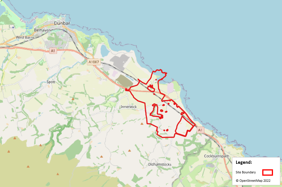
The Proposed Development site is shown in Figure 1 The site is located to the east of Dunbar and Innerwick in East Lothian.
2.2 Proposed Development
The layout of the Proposed Development is presented in Figure 2
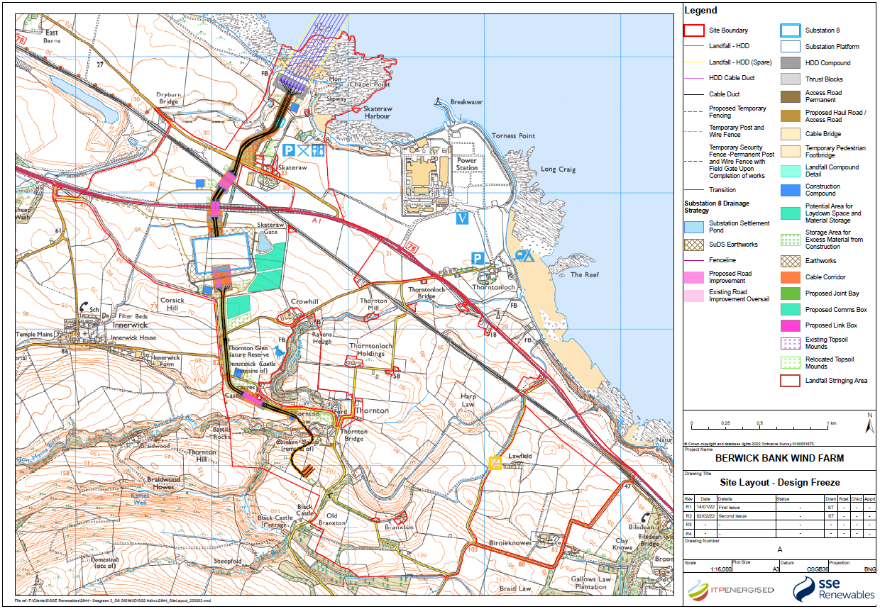
Figure 2 Substation Locations and Landfall Locations (courtesy of ITPEnergised and SSE Renewables)
In summary, the Proposed Development (the OnTW) will comprise the following:
- A new onshore substation;
- Cable landfall;
- Underground cable route connections between the landfall and the onshore substation, and between the onshore substation and the grid connection substation; and
- Associated ancillary infrastructure.
The onshore substation is located on an agricultural field, approximately 350 m south of Skateraw, and 380 m north-west of Crowhill. Its location is shown in Figure 2 by a blue rectangle. The location of the cable landfall at Skateraw is also presented in Figure 2
The Proposed Development will be designed to have an operational life of 35 years.
A complete description of the Proposed Development for the purposes of the EIA regulations is presented in Volume 1; Chapter 5.
3 Policy Context
3.1 Introduction
An overview of relevant transport planning policies has been undertaken and is summarised below for national and local government policies.
3.2 National Policy
3.2.1 National Planning Framework 4 (2023)
The Revised Draft National Planning Framework 4 was laid in Parliament on 08 November 2022. The Revised Draft National Planning Framework 4 was approved by Scottish Parliament on 11 January 2023 and was then passed to Scottish Ministers who adopted the National Planning Framework 4 (NPF4) on 13 February 2023.
With regards to traffic and transport and the Proposed Development, Policy 11: Energy within the NPF4 notes that:
“Development proposals for all forms of renewable, low-carbon and zero emissions technologies will be supported. These include:
- Wind farms including repowering, extending, expanding and extending the life of existing wind farms; and
- Enabling works, such as grid transmission and distribution infrastructure.
In addition, project design and mitigation will demonstrate how the following impacts are addressed:
- Impacts on communities and individual dwellings, including, residential amenity, visual impact, noise and shadow flicker;
- Public access, including impact on long distance walking and cycling routes and scenic routes;
- Impacts on road traffic and on adjacent trunk roads, including during construction; and
- Cumulative impacts.”
3.2.2 Transport Assessment Guidance (2012)
Transport Scotland’s (TS) Transport Assessment Guidance was published in 2012. It aims to assist in the preparation of TA for development proposals in Scotland such that the likely transport impacts can be identified and dealt with as early as possible in the planning process. The document sets out requirements according to the scale of development being proposed.
The document notes that a TA will be required where a development is likely to have significant transport impacts but that the specific scope and contents of a TA will vary for developments, depending on location, scale, and type of development.
3.2.3 Planning Advice Note (PAN) 75
Planning Advice Note (PAN) 75: Planning for Transport provides advice on the requirements for TA. The document notes that:
“… transport assessment to be produced for significant travel generating developments. Transport Assessment is a tool that enables delivery of policy aiming to integrate transport and land use planning.”
“All planning applications that involve the generation of person trips should provide information which covers the transport implications of the development. The level of detail will be proportionate to the complexity and scale of the impact of the proposal...For smaller developments the information on transport implications will enable local authorities to monitor potential cumulative impact and for larger developments it will form part of a scoping exercise for a full transport assessment. Development applications will therefore be assessed by relevant parties at levels of detail corresponding to their potential impact.”
3.3 Local Policy
3.3.1 East Lothian Local Development Plan (2018)
The East Lothian Local Development Plan (LDP) was adopted by East Lothian Council (ELC) in September 2018 and is established planning policy for ELC area. It sets out a planning strategy and policies to guide the future development. The following policies are relevant to the Proposed Development:
Policy T1: Development Location and Accessibility
“New developments shall be located on sites that are capable of being conveniently and safely accessed on foot and by cycle, by public transport as well as by private vehicle, including adequate car parking provision in accordance with the Council’s standards. The submission of Travel Plans may also be required in support of certain proposals.”
Policy T2: General Transport Impact
New development must have no significant adverse impact on:
- Road safety;
- The convenience, safety and attractiveness of walking and cycling in the surrounding area;
- Public transport operations in the surrounding area, both existing and planned, including convenience of access to these and their travel times;
- The capacity of the surrounding road network to deal with traffic unrelated to the proposed development; and
- Residential amenity as a consequence of an increase in motorised traffic. Where the impact of development on the transport network requires mitigation, this will be provided by the developer and secured by the Council by planning condition and / or legal agreement where appropriate.
Policy T4: Active Travel Routes and Core Paths as part of the Green Network Strategy
“The Council will protect its existing core path and active travel networks and ensure that new development does not undermine them, including the convenience, safety and enjoyment of their use.”
3.3.2 East Lothian Local Transport Strategy (2018 – 2024)
The East Lothian Local Transport Strategy (LTS) was prepared by ELC and details the transport strategy for the period between 2018 and 2024. It is noted that the main aim of the LTS is to provide a mechanism for clean, green and safe travel patterns across the County and beyond.
In relation to Strategic Road Network, the LTS notes that:
“The A1 road is a major transport artery through the country but is now approaching capacity in some places. In particular, it is single carriageway south of Dunbar causing congestion and unreliable journey times.”
3.4 Policy Summary
The Proposed Development can align with the stated policy objectives and the design of the site and proposed mitigation measures will ensure compliance with national and local objectives.
4 Study Methodology
4.1 Introduction
There are three phases of the life of the Proposed Development. All three phases have been considered in this assessment and are as follows:
- The Construction Phase;
- The Operational and Maintenance Phase; and
- The Decommissioning Phase.
4.2 Project Phases – Transport Overview
Of all of the three phases, the construction phase is considered to have the greatest impact in terms of transport. Construction plant and bulk materials will be transported to site, potentially have a significant increase in traffic on the study network.
The decommissioning phase involves fewer trips on the network than the construction phase, as minor elements of infrastructure are likely to be left in place, adding to local infrastructure that can potentially be used for further agricultural or leisure uses in the future.
The operational and maintenance phase is restricted to occasional maintenance operations which generate significantly lower volumes of traffic that are not considered to be in excess of daily traffic variation levels on the road network.
It should be noted however the construction effects are short lived and transitory in nature.
4.3 Scoping Discussions
The Applicant submitted a request in August 2020 for Scoping Opinion to ELC in respect of the Environmental Impact Assessment which included a section considering traffic and transport.
A full review of that Scoping Opinion is provided in the Traffic and Transport Chapter of the Onshore EIA (Volume 1: Chapter 12).
5 Baseline Conditions
5.1 Access Arrangements
It is proposed that all construction related vehicles will use the A1 trunk road (T) to access the site from the surrounding areas. The various elements of the Proposed Development are subsequently accessed via the local road network where upgraded access junctions will be provided. Indicative drawings of the access junctions are provided in Appendix A.
The Abnormal Load Route Assessment Report[1] was prepared by Sweco and shows the assessment of delivery routes for abnormal transformer loads. This is presented in EIA Volume 4, Appendix 12.2.
5.2 Study Area Determination
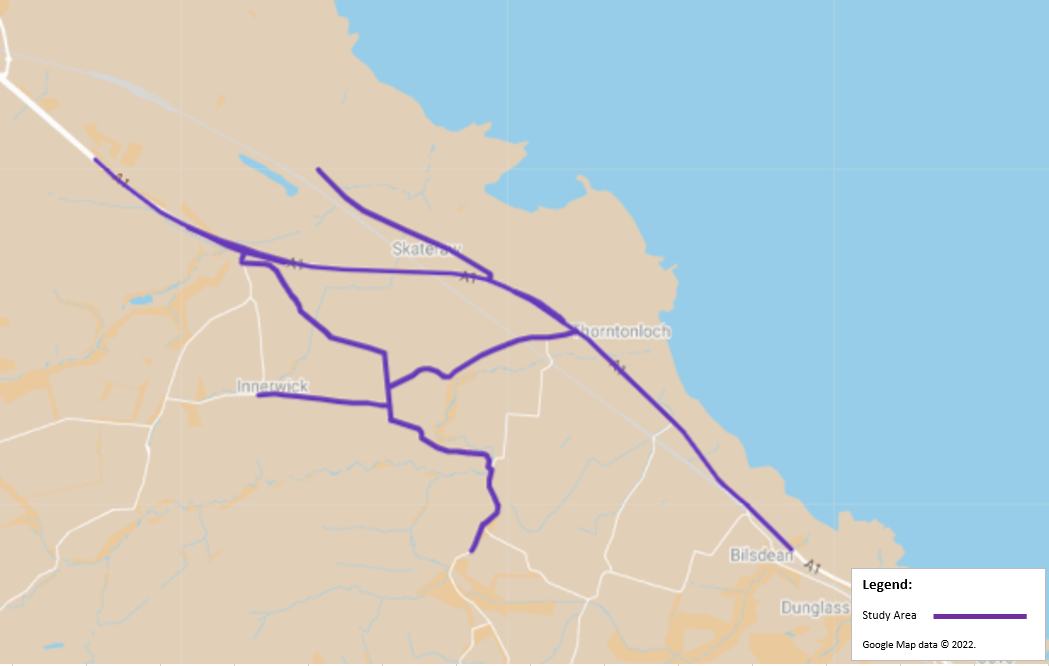
Scoping was undertaken with ELC and Transport Scotland in order to agree the scope of the TA and develop a transport study area. The traffic and transport study area includes local roads that are likely to experience increased traffic flows from the Proposed Development.
The traffic and transport study area was determined through a review of Ordnance Survey (OS) plans and an assessment of the likely points of origin for construction materials and construction staff.
Strategic access to the site is available from the A1 (T) network which is operated by Bear Scotland on behalf of Transport Scotland. Access to the different elements of the Proposed Development will be via the local road network.
The study area for this assessment is as follows:
- The A1 (T) between Easter Pinkerton and Bilsdean;
- The local road network in Skateraw; and
- Th local road network around Innerwick and Thorntonloch, including the U209, the C121, the C122 and the C124.
The study area network is illustrated by the purple line in Figure 3
5.3 Pedestrian and Cyclist Networks
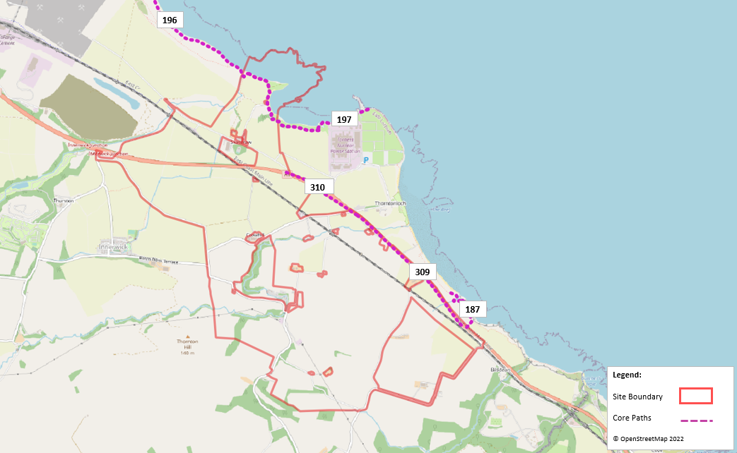
A review of ELC’s Core Path Plans on East Lothian Council’s Map K[2] Innerwick and Surrounding Area indicates core paths which are located within the site.
Core Paths 309 connects to Core Path 310 and comprises a tarred path which runs along the boundary of the A1 (T), within the eastern section of the site.
Core Path 196 connects to Core Path 197 and forms part of John Muir Way. Core Path 187 also forms part of John Muir Way. The Walks around Dunbar paths leaflet notes that:
“The John Muir Way is being developed by East Lothian Council to provide a continuous path between Edinburgh and the Scottish Borders. The route is still being developed and much of what currently exists follows the coast line. It is planned for the route to link into East Linton, North Berwick and Gullane.”
The Core Path network in the vicinity of the Site are presented in Figure 4
A review of Sustran’s National Cycle Network online mapping resource (The National Cycle Network - Sustrans.org.uk) shows that National Cycle Route (NCR) 76 is located within the site and comprises both on-road and off-road cycle route. NCR 76 connects the site to Edinburgh, Musselburgh, Haddington and Skateraw to the west. To the east of the site, the cycle route comprises an on-road route, which is not on the National Cycle Network, and connects to Eyemouth, Scotland and Berwick-upon-Tweed, England.
5.4 Road Access
Access to the different elements of the Proposed Development will be as follows:
- In order to access the onshore substation, construction vehicles will leave the A1 (T) at Innerwick junction and will continue towards the onshore substation site access via the U209 (north of Barnes Ness Terrace) .
- To access the cable landfall, construction vehicles will leave the A1 (T) at the A1 (T) / Skateraw priority junction and will continue towards the landfall site via the unclassified road to Skateraw.
- In relation to the cable route, there are several site access / egress locations which are as follows:
- Cable (1 – 3) Sites – Construction vehicles will leave the A1 (T) at the A1 (T) / Skateraw priority junction and will continue towards the site access via the unclassified road to Skateraw;
- Cable (4) Site – Construction vehicles will leave the A1 and access the Site via a newly formed left-in access junction from the A1. Vehicles exiting the site will egress via Skateraw and through the A1 (T) / Skateraw priority junction;
- Cable (5) Sites – Construction vehicles will leave the A1 (T) at Innerwick junction and join the local road network. Approximately 70m after the Innerwick junction, vehicles will turn left towards Crowhill / Oldhamstocks. Approximately 180m along this road, vehicles will access the Cable (5) site via a newly upgraded access junction. Vehicles will access /egress the site at this location;
- Cable (6 – 8) Sites – Construction vehicles will leave the A1 (T) at Innerwick junction and join the local road network. Approximately 70m after the Innerwick junction, vehicles will turn left towards Crowhill / Oldhamstocks and will continue along this road until they reach their respective accesses; and
- Cable (9) Site – Construction vehicles will leave the A1 (T) at Innerwick junction and join the local road network. Approximately 70m after the Innerwick junction, vehicles will turn left towards Crowhill / Oldhamstocks and will continue along this road and across Thornton Bridge towards the site access.
The location of the proposed access and egress locations are shown in Figure 5
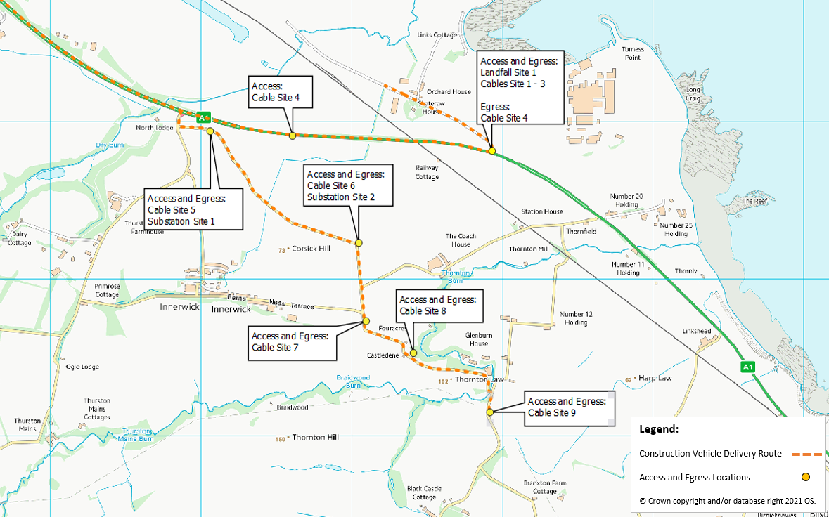
Figure 5 Access / Egress Locations for the various elements of the Proposed Development
The East Coast Main Line railway runs through the study area. Bridges are located along the C124 (near Blackberry Farm Paddocks) and the A1 (T), to the south of Skateraw to enable the railway to run underneath the roads.
It is proposed that permanent, surfaced single carriageway roads will be constructed to connect the onshore substation to the public highway which will include the provision of passing places.
Some sections of the public roads will require works such as permanent widening, resurfacing or passing places to enable access to the Proposed Development site. Such works will be agreed with ELC and TS.
The unnamed road at Skateraw is a two-way single carriageway which is subject to the national speed limit and bounded by mainly agricultural land.
The C122 leading from the A1 (T) to Innerwick and Crowhill (near Thurston Doggy Daycare) is a two-way single carriageway which is subject to the national speed limit.
The U209 (north of Barnes Ness Terrace) which forms a priority junction with the above road and is signed as Crowhill and Oldhamstocks appears to be a narrow two-way single carriageway road which is bound by agricultural land.
The C121, to the north of Border Belles garden centre, is a narrow two-way single carriageway which is bound by mainly hedgerows, trees and agricultural land.
The C124, near Blackberry Farm Paddocks, is a two-way single carriageway which is bound by mainly agricultural land. The road is deemed unsuitable for HGVs and a narrow bridge is located along the road to cross the East Coast Main Line.
C121 Barns Ness Terrace is a two-way single carriageway. The western section of C121 Barns Ness Terrace runs along the south of Innerwick village and is subject to a speed limit of 30mph. The eastern section of C121 Barns Ness Terrace is bound mainly by agricultural land and is subject to the national speed limit.
The A1 (T) provides strategic access to the Proposed Development and provides a connection between Edinburgh and London. In the vicinity of the study area, the A1 (T) is a two-way single carriageway which is subject to the national speed limit, which is enforced by the presence of speed cameras.
5.5 Existing Traffic Conditions
In order to assess the impact of the Proposed Development traffic on the study area Automatic Count (ATC) sites were established in November and December 2021 at the following locations:
- Skateraw;
- C122 (near Thurston Doggy Daycare);
- U209 (north of Barns Ness Terrace);
- C121 (north of Border Belles);
- C124 (near Blackberry Farm Paddocks); and
- C121 (Barns Ness Terrace).
Additional traffic data was obtained from existing traffic sources from the TS database. The TS database contains live traffic information. Available traffic data for 2019 was extracted as this traffic information would not be affected by Covid-19 traffic restrictions.
National Road Traffic Forecasts (NRTF) low growth factors were applied to the 2019 data to estimate 2021 flows (2019/2021 = 1.016).
The location for the TS traffic survey site which is closest to the site is as follows:
- TS Count Number JTC00418 – A1 Thortonloch.
The locations of the count sites are illustrated in Figure 6
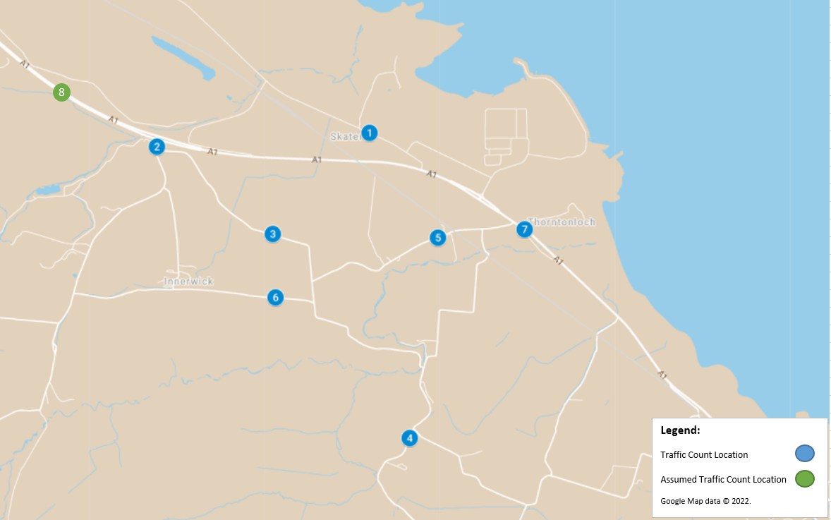
Figure 6 ATC Traffic Count Locations
Although the traffic count site along the A1 (T) (counter 7 in Figure 6) is to the east of the A1 (T) / Skateraw junction, it is assumed that the traffic volume at this location equates to traffic to the west of the Innerwick junction (counter 8 in Figure 6).
These sites were identified as being areas where sensitive receptors on the access route would be located. A full receptor sensitivity and effect review is prepared in the Traffic and Transport Chapter of the EIA Report (Volume 1: Chapter 12).
The traffic counters allowed the traffic flows to be split into vehicle classes and the data have been summarised into cars/ light goods vehicles (LGVs) and heavy goods vehicles (HGVs) (all goods vehicles >3.5 tonnes gross maximum weight).
Table 1 summarises the 24-hour average daily traffic data collected at the count sites.
Table 1 24-hour Average Traffic Data (2021)
The ATC sites used to provide traffic volume data were also used to collect speed statistics. The two-way five-day average and 85th percentile speeds observed at the count locations are summarised in Table 2.
* 2021 two-way seven-day average and 85th percentile speeds
**There is no speed data available at count location no. 8, as this is an estimated count location based on traffic flows sourced from count location 7
The speed survey data indicates that there is compliance with the current speed limits within the study area.
5.6 Accident Review
Road traffic accident data for the five-year period commencing 01 January 2016 through to the 31 December 2020 was obtained from the online resource crashmap.co.uk which uses data collected by the police about road traffic crashes occurring on British roads.
The statistics are categorised into three categories, namely “Slight” for damage only incidents, “Serious” for injury accidents and “Fatal” for accidents that result in a death.
A summary analysis of the incidents indicates that:
- A total of 14 accidents were recorded within the study area roads within the five year period;
- Of those, 10 were classified as slight, four as serious and none were recorded as a fatality;
- A total of 13 accidents were recorded along the A1 (T), while one accident was recorded along an unnamed road approximately 300m north west of Bilsdean;
- A total of three of the recorded accidents involved HGVs. Two incidents were recorded as slight and occurred at A1 (T) / Torness Power Station junction and the other occurred along the A1 (T), to the north of the Pet Crematorium. One incident involving HGVs was recorded as serious and occurred at the A1 (T) / C124(near Blackberry Farm Paddocks) priority junction;
- Four accidents were recorded along the A1 (T) in the vicinity of the Torness Power Station, which were all classified as slight;
- A total of two accidents along the A1 (T) resulted in child casualties; and
- It should be noted that two of the recorded accidents along the A1 (T) did not include vehicle type information.
5.7 Baseline Traffic Conditions
Construction of the Proposed Development could commence during 2025 if consent is granted and is anticipated to take up to 40 months depending on weather conditions and ecological considerations. For the purpose of the TA, it is proposed that future year which is assessed as the future year baseline will be 2026, as it is anticipated that the peak construction period is anticipated to occur in this year.
To assess the likely effects during the construction and typical operational phase, base year traffic flows were determined by applying a NRTF low growth factor to the surveyed traffic flows.
The NRTF low growth factor for 2021 to 2026 is 1.027. These factors were applied to the 2021 survey data to estimate the 2026 Base traffic flows shown in Table 3. This will be used in the Construction Peak Traffic Impact Assessment.
6 Trip Generation and Distribution
6.1 Construction Phase
6.1.1 Trip Derivation
Average monthly traffic flow data was used to establish the construction trips associated with the Proposed Development. These trip estimates were provided by SSE Renewables and are based upon their experience from similar projects.
Trip generation estimates associated with each element of the Proposed Development is provided in Appendix B of this TA.
6.1.2 Distribution of Construction Trips
The trip estimates have been based upon first principle estimates of traffic movements to and from the site, having established the likely volumes of construction materials, resources and components.
It is proposed that material associated with the construction phase of the Proposed Development will be sourced from the Central Belt and will be delivered to the site via the A1 (T).
All staff are expected to arrive to the site from the north, along the A1 (T).
The Port of Entry (PoE) for any abnormal loads will be the Port of Dundee. Abnormal load deliveries will subsequently travel to the site via East Dock Street, Kingsway East, A90, M90, A720 and the A1 (T) towards the site.
The trip estimates have been assigned to the proposed construction programme to allow the identification of the peak of construction traffic to be established. The construction programme is provided in Appendix C.
The peak of construction traffic activity was identified as being Month 14 of the programme. The traffic associated with this month was then assigned to the study area network using the distribution of traffic described above.
The peak traffic flows associated with the Proposed Development’s construction phase results in an average of 669 movements per day (335 trips in and 335 trips out), of which 522 would be made by light vehicles (261 inbound and 261 outbound) and 147 by HGV (74 inbound and 74 outbound).
The construction traffic was compared against the future baseline traffic to estimate the increase in traffic associated with this phase of the Proposed Development. Table 4 illustrates the potential traffic impact at the peak of construction activity.
Table 4 Peak Construction Traffic
Based on an assumption of 22 working days per month.
6.2 Committed Developments
During the Scoping Opinion stage ELC’s response regarding Roads and Transport noted that there are no other developments or infrastructure schemes to be taken into account when considering potential cumulative traffic and transport impacts other than Neart na Gaoithe construction activities.
A review of the Neart na Gaoithe development’s website indicates that it is anticipated that full commissioning of Neart na Gaoithe is expected to be completed in 2023. Meanwhile it is anticipated that construction of the Proposed Development will commence in 2025, should planning be granted in 2022. It can be reasonable concluded that Neart na Gaoithe will be fully commissioned prior to construction activities commencing at the Proposed Development. While the transport impacts associated with Neart na Gaoithe will not be assessed as part of the cumulative assessment, the traffic activities associated with Neart na Gaoithe are captured in the baseline traffic flows as noted in Table 1.
Crystal Rig IV Wind Farm was granted planning permission for up to 11 wind turbines, with a maximum tip height of up to 200m since the Scoping Opinion was issued (October 2020). Traffic flows associated with the consented Crystal Rig IV Wind Farm have not been included in the 2026 Baseline Flows as the inclusion of further traffic flows in the baseline will dilute the potential impact that the Berwick Bank OnTW proposals will have. This approach is considered to be an overly robust assessment.
In order to inform the planning authorities of possible issues if Crystal Rig IV Wind Farm was to be constructed concurrently with the Proposed Development, a combined sensitivity review will be undertaken as part of the cumulative assessment in Volume 1 Chapter 12.
The Eastern Link Project proposals (Northern Point of Connection Converter Station and Cables and Northern Point of Connection Substation) and Branxton Grid Substation developments are to comprise a new substation, overhead line, converter station, underground cables and marine cables near Torness, East Lothian. The planning submission for the Branxton Grid Substation is withdrawn, however it is expected to be resubmitted in the future, while a planning submission for the Eastern Link Project’s proposals are in the planning system. While these planning applications have not been consented and are not considered committed developments, they are examined within the sensitivity review in Volume 1: Chapter 12 at the request of the Applicant in order to inform the planning authorities of possible issues if the Eastern Link Project is constructed simultaneously with the Proposed Development.
It should be noted that any crossover of traffic with the Proposed Development’s flows would be addressed via an overarching traffic management plan.
The use of NRTF growth factors for background traffic is considered robust for addressing smaller, non-significant traffic generation caused by smaller developments within the study area.
6.3 Decommissioning Phase
Prior to decommissioning of the site, a traffic assessment will be undertaken and appropriate traffic management procedures followed.
The decommissioning phase would result in fewer trips on the road network than the construction or operational phases as it is likely that elements of infrastructure such as access tracks would be left in place and structures may be broken up onsite to allow a reduced number of HGVs.
7 Traffic Impact Assessment
7.1 Construction Impact
The peak month traffic data was combined with the future year (2026) traffic data to allow a comparison between the baseline results to be made. The increase in traffic volumes is illustrated in percentage increases for each class of vehicle. This is illustrated in Table 5.
Table 5 2026 Peak Month Daily Traffic Data
Please note minor variances may occur due to rounding.
The total traffic movements are predicted to increase by more than 30% along Skateraw and U209 (north of Barns Ness Terrace).
The table shows that traffic movements will increase by a total of 179.6% and the HGV movements are predicted to increase by 117.2% along the road leading to Skateraw. Whilst these increases are statistically significant, they are generally caused by relatively low total and HGV flows on this road which will see an additional 262 Cars & LGV and 59 HGV daily journeys during the peak. This represents a total of approximately 13 inbound trips every hour which is not considered overly significant in terms of overall traffic flows.
Along the U209 (north of Barns Ness Terrace) it is anticipated that traffic movements will increase by a total of 157.6% and the HGV movements will increase by 194.0%. Although these increases are statistically significant, they are caused by relatively low total and HGV flows on this road which will see an additional 170 Cars & Lights and 52 HGV daily journeys during the peak. This represents a total of approximately seven inbound Car & LGV trips and approximately two HGV trips every hour which is not considered significant in terms of overall traffic flow terms.
It should also be noted the construction phase is transitory in nature and the peak of construction activities is short- lived.
A review of existing road capacity has been undertaken using the Design Manual for Roads and Bridges, Volume 15, Part 5 “The NESA Manual”. The theoretical road capacity has been estimated for each of the road links for a 12-hour period that makes up the study area. The results are summarised in Table 6.
Table 6 2026 Daily Traffic Data
The results indicate there are no road capacity issues with the proposed development and ample spare capacity exists within the trunk and local road network to accommodate construction phase traffic.
8 Proposed Traffic Mitigation Measures
8.1 Construction Phase
The following measures are to be implemented through a Construction Traffic Management and Routeing Plan (CTMRP) during the construction phase of the Proposed Development:
- Proposed Works – including identified road improvements and bridge improvements;
- Route Assessment – including proposed site access, route condition survey, routeing management and details of vehicles accessing the site;
- Abnormal Load Assessment – including details on the abnormal loads to be delivered to the site, abnormal load delivery vehicles, vehicle routeing, escort strategy and contingency plan; and
- Traffic Impact Mitigation Measures – including measures for abnormal loads, such as advanced warning signage and providing information to the general public, measures for all traffic such as site induction briefings and each HGV delivery vehicle being individually marked.
A CTMRP is presented in Appendix D and contains full details of the proposed measures to be implemented during the construction phase of the Proposed Development. The measures outlined in the CTMRP will be agreed with ELC and TS prior to construction works commencing.
8.2 Abnormal Load Management Plan
There are a number of traffic management measures that could help reduce the effect of abnormal load deliveries.
All abnormal load deliveries would be undertaken at appropriate times (to be discussed and agreed with the relevant roads authorities and police) with the aim to minimise the effect on the local road network. It is likely that the abnormal load convoys would travel in the early morning periods, before peak times while general construction traffic would generally avoid the morning and evening peak periods.
The majority of potential conflicts between construction traffic and other road users will occur with abnormal load traffic. General construction traffic is not likely to come into conflict with other road users as the vehicles are smaller and road users are generally more accustomed to them.
Advance warning signs would be installed on the approaches to the affected road network. Information signage could be installed to help assist drivers and an example is illustrated in Figure 7 Flip up panels (shown in grey) would be used to mask over days where convoys would not be operating. When no convoys are moving, the sign would be bagged over by the Traffic Management contractor.

Figure 7 Example Information Sign
This signage will assist in helping improve driver information and allow other road users to consider alternative routes or times for their journey (where such options exist).
The location and numbers of signs would be agreed post consent and would form part of the wider Traffic Management Proposal for the Proposed Development.
The Abnormal Load Transport Management Plan would also include:
- Procedures for liaising with the emergency services to ensure that police, fire and ambulance vehicles are not impeded by the loads. This is normally undertaken by informing the emergency services of delivery times and dates and agreeing communication protocols and lay over areas to allow overtaking;
- A diary of proposed delivery movements to liaise with the communities to avoid key dates such as local events;
- A protocol for working with local businesses to ensure the construction traffic does not interfere with deliveries or normal business traffic; and
- Proposals to establish a construction liaison committee to ensure the smooth management of the project / public interface with the Applicant, the construction contractors, the local community, and if appropriate, the police forming the committee. This committee would form a means of communicating and updating on forthcoming activities and dealing with any potential issues arising.