

EXECUTIVE SUMMARY
Overview
Berwick Bank Wind Limited (the Applicant) is proposing the development of the Berwick Bank Wind Farm (the Project) in the outer Firth of Forth and Firth of Tay, 39.2 km east, at its closest point, of the East Lothian coastline. The export cables will make landfall on the East Lothian coast, at Thorntonloch and/or at Skateraw Harbour. From here, the onshore cable route will connect to a proposed substation and then onto Scottish Power Transmission’s 400kV Grid Substation located at Branxton, south of Torness Power Station.
This document requests an Environmental Impact Assessment (EIA) Scoping Opinion from East Lothian Council (ELC) in consultation with statutory and non-statutory consultees in relation to the scope of the EIA (for the Onshore Transmissions Works [the Proposed Development] associated with the Project). It provides the background to the Project and the Proposed Development and legislative context, an overview of the site selection and development design, a summary of the proposed EIA methodology including cumulative assessment, the proposed receptors and impacts to be included (scoped in) and excluded (scoped out) from the EIA, and a preliminary list of tertiary mitigation measures.
A separate Offshore EIA Scoping Report (and associated Offshore EIA Report) relating to offshore infrastructure will be submitted to Marine Scotland in support of the offshore Proposed Development consent Application. Where there is an overlap in jurisdiction in the intertidal area between Mean High Water Spring and Mean Low Water Spring of the onshore and offshore consenting and regulatory regimes, both the Onshore Scoping Report and the Offshore Scoping Report presents the relevant technical assessments. The proposed method for cumulative assessment addresses this overlap and the potential for cumulative effects from both the offshore and onshore Project infrastructure.
Key Scoping Outcomes
Key potential impacts on receptors which have the potential to result in significant effects, beneficial and adverse, from the construction, operation or decommissioning of the Proposed Development, following the proposed implementation of tertiary mitigation, have been identified and scoped into the Onshore EIA Report for further assessment. Generally, these include:
- Landscape and visual – landscape and visual impacts on receptors as a result of the substation’s construction, operation and decommissioning; and impacts from the landfall(s) and cable route during construction only.
- Ecology and ornithology – impacts on nature conservation designations, coastal habitats and woodland during construction only; impacts on field boundaries and protected species including birds during construction and decommissioning; and impacts from invasive species during construction, operation or decommissioning.
- Noise - impacts on receptors as a result of traffic noise, substation vibration activities, landfall(s) and cable route noise and vibration activities during construction only; and impacts on receptors from substation noise activities during construction and operation.
- Cultural heritage – impacts on the setting of heritage assets (within 5km of the Proposed Development) during construction and operation; and direct effects on heritage assets from the landfall(s) and cable route, and substation during construction only.
- Geology, hydrology, flood risk and soils – impacts on statutory designated sites, soil erosion, flood risk and private water supplies during construction only.
- Traffic and transport – impacts from construction traffic only.
- Socio-economics - direct, indirect and induced employment impacts and gross value added impacts during construction, operation and decommissioning.
- Land use, recreation and tourism – direct impacts on land use, recreation and tourism receptors during construction; and indirect impacts on recreation and tourism receptors during construction and operation.
The technical topics of air quality and electric and magnetic fields have been scoped out of further assessment. It is anticipated that through the implementation of identified tertiary mitigation measures any potential effects would be reduced to non-significant.
How to Get Involved
If you would like more information on the Project or Proposed Development please visit https://www.sserenewables.com/berwickbankandmarrbank or email enquiries to berwickandmarr.enquiries@sse.com.
Next Steps
Following submission of this Onshore Scoping Report to ELC, the Applicant will undertake further consultation with statutory and non-statutory consultees where necessary, undertake environmental surveys and studies, finalise the design of the Proposed Development and submit a planning application to ELC accompanied by the Onshore EIA Report. Submission of the application is anticipated to be towards the end of 2021.
ACRONYMS AND ABBREVIATIONS
Acronym | Definition |
|---|---|
AADT | Annual Average Daily Traffic |
AAWT | Annual Average Weekday Traffic |
ACoW | Archaeological Clerk of Works |
APR | Annual Progress Report |
AQMA | Air Quality Management Area |
AQS | Air Quality Standard |
ASA | Archaeologically Sensitive Area |
AWI | Ancient Woodland Inventory |
BCT | Bat Conservation Trust |
BGS | British Geological Society |
BPM | Best Practicable Means |
BSI | British Standards Institution |
BTO | British Trust for Ornithology |
CAR | Controlled Activities Regulations |
CBC | Common Bird Census |
CEMP | Construction Environment Management Plan |
CIEEM | Chartered Institute of Ecology and Environmental Management |
CTMP | Construction Traffic Management Plan |
DECC | Department of Energy and Climate Change |
DEFRA | Department for Environment Food and Rural Affairs |
DfT | Department for Transport |
DMRB | Design Manual for Roads and Bridges |
EcIA | Ecological Impact Assessment |
ECML | East Coast Main Line |
ECoW | Ecological Clerk of Works |
EIA | Environmental Impact Assessment |
EIAR | Environmental Impact Assessment Report |
ELC | East Lothian Council |
ELCAS | East Lothian Council Archaeological Service |
EMF | Electric and Magnetic Fields |
EPUK | Environmental Protection UK |
GDL | Garden and Designed Landscape |
GIS | Gas Insulated Switchgear |
GLVIA | Guidelines for Landscape and Visual Impact Assessment |
GPP | Guidance for Pollution Prevention |
GPS | Global Positioning System |
GVA | Gross Value Added |
HDD | Horizontal Directional Drilling |
HER | Historic Environment Record |
HES | Historic Environment Scotland |
HGV | Heavy Goods Vehicle |
HLA | Historic Land-Use Assessment |
HVAC | High Voltage Alternating Current |
HVDC | High Voltage Direct Current |
IAQM | Institute of Air Quality Management |
IEFs | Important Ecological Features |
IEMA | Institute of Environmental Management and Assessment |
ITPE | ITPEnergised |
JNCC | Joint Nature Conservation Committee |
LAQM | Local Air Quality Management |
LB | Listed Building |
LBAP | Local Biodiversity Action Plan |
LCS | Landscape Capacity Study |
LCA | Land Capability for Agriculture |
LCT | Landscape Character Type |
LDV | Light Duty Vehicle |
LVIA | Landscape and Visual Impact Assessment |
MLWS | Mean Low Water Spring |
NCR | National Cycle Route |
NIDL | Non-Inventory Designed Landscape |
NOx | Nitrogen Oxide |
NO2 | Nitrogen Dioxide |
NnG | Neart na Gaoithe |
NPF | National Planning Framework |
NRC | National Cycle Route |
NRHE | National Record of the Historic Environment |
NRMM | Non-Road Mobile Machinery |
NVC | National Vegetation Classification |
OHL | Over Head Line |
OnTW | Onshore Transmission Works |
OSEC | Outline Schedule of Environmental Commitments |
PDT | Passive Diffusion Tube |
PiC | Property in Care |
PM10 | Particulate matter with a diameter of less than 10 micrometres |
PM2.5 | Particulate matter with a diameter of less than 2.5 micrometres |
PPG | Pollution Prevention Guidelines |
PPV | Peak Particle Velocity |
PRoW | Public Rights of Way |
SEPA | Scottish Environment Protection Agency |
SSER | SSE Renewables |
SSSI | Site of Special Scientific Interest |
SLA | Special Landscape Area |
SM | Scheduled Monument |
SNH | Scottish Natural Heritage |
SPG | Supplementary Planning Guidance |
SPA | Special Protection Area |
SPP | Species Protect Plan |
SUDS | Sustainable Urban Drainage System |
SWT | Scottish Wildlife Trust |
WeBS | Wetland Bird Survey |
WFD | Water Framework Directive |
WQMP | Water Quality Monitoring Programme |
ZAP | Zone Appraisal and Planning |
ZDA | Zone Development Agreement |
ZTV | Zone of Theoretical Visibility |
UNITS
Definition | |
dB(A) | Decibels measured on a sound level meter incorporating a frequency weighting (A weighting) which differentiates between sounds of different frequency (pitch) in a similar way to the human ear. Measurements in dB(A) broadly agree with people’s assessment of loudness. |
GW | Gigawatts |
Hz | Is the derived unit of frequency in the International System of Units (SI) and is defined as one cycle per second |
km | Kilometre |
m | Metre |
MW | Mega Watt |
µg/m3 | Ambient concentration of a pollutant in micrograms per cubic metre |
ha | Hectare |
GLOSSARY
Term | Definition |
|---|---|
Trenchless technology | Trenchless technology is a type of subsurface construction work which can be completed without the need for continuous open trenches. The operation can be completed using a number of methods, materials and equipment capable of installing new below ground cabling with minimal disruption to the at-surface infrastructure or activities. Some examples of this construction method include Horizontal Direction Drilling (HDD), Pipe Thrusting and Micro-tunnelling. |
Open Cut Trenching (on land) | Open cut trenching is a traditional method of cable installation. On land it requires opening up the surface of the ground through excavation to the required depth to lay the cable. Following installation, the trench will be backfilled and land that is used for temporary access will be restored. |
Open Cut Trenching (at landfall(s)) | Open cut trenching at the landfall(s) location would follow the method described above but also require temporary sheet pile walls allowing the opening of a trench through unstable wet beach sands. Across the nearshore, high-energy littoral zone, shallow water dredging techniques would be employed. Once sufficient depth is reached, submerged trenching equipment will take over. |
High Voltage Direct Current (HVDC) | High Voltage Direct Current (HVDC) is used to transmit power from offshore substations to onshore substations. HVDC systems use direct current for the transmission of electrical power, using converters at the offshore substation to converter AC power generated by the WTG to DC, and returning the power to AC at the onshore substation for connection to the AC transmission grid. |
High Voltage Alternating Current (HVAC) | High Voltage Alternating Current (HVAC) is used to transmit power from the offshore substation to the onshore substations. HVAC systems use alternating current for the transmission of electrical power, increasing the voltage of the AC power generated by the WTG’s to a higher voltage to allow efficient transmission over long distances and connection to at the transmission system. |
Search Area for the Site Boundary | Due to ongoing investigations, the Proposed Development site boundary cannot be defined at the time of reporting. Therefore, a Search Area for the Site Boundary has been defined. No infrastructure will be located outwith this area. For the purposes of scoping the Environmental Impact Assessment, this Search Area has been used for the identification of receptors which are considered to have potential to be impacted by the Proposed Development. |
Planning Application Boundary | The Proposed Development site boundary which will be finalised with submission of the EIA and will encompass the boundary of the land to be developed. |
- INTRODUCTION
- Background
Background
INTRODUCTION Background
In 2009 Seagreen Wind Energy Limited (“Seagreen”) was awarded development rights to R3 Zone 2 (named ‘Firth of Forth Zone’), and subsequently Seagreen and the Crown Estate entered into a Zone Development Agreement (ZDA) with a target Zone generation capacity of circa 3.5 gigawatts (GW).
The ZDA granted Seagreen certain seabed rights within the Zone, such as to identify specific areas for the development of offshore wind farms. Although the boundary of the Zone was fixed, development phase and project boundaries remained flexible within the Zone.
Seagreen opted for a phased approach to the delivery of the projects within the Zone to achieve the target capacity of around 3.2 GW. This approach involved prioritising areas considered to have the least potential constraints and considering the practicalities of resourcing delivery of the target capacity for the Zone. To support the definition of Phases and Project boundaries rationally and strategically, Seagreen adopted the Zone Appraisal and Planning (ZAP) approach.
Sites were ranked on the level of constraint and ability to construct. Phase 1, Phase 2 and Phase 3 project boundaries were developed. The Phase 1 projects consist of Project Alpha and Project Bravo laterally Seagreen Offshore Wind Farm which was awarded consent in November 2017 for 1.5 GW, with construction commencing in 2020. Phase 2 projects of the Firth of Forth Zone consists of Project Charlie, now Berwick Bank Wind Farm, and Project Delta, now Marr Bank Wind Farm, which could generate a combined potential of around 3.2 GW of renewable electricity.
The Applicant is now proposing to take forward the second area (Berwick Bank Wind Farm, formerly named Seagreen 2 and hereafter referred to as “the Project”) and apply for 50 year consent required to build, operate and decommission the offshore and onshore infrastructure. This document is the Environmental Impact Assessment (EIA) Scoping Report for the proposed Onshore Transmission Works (OnTW) associated with Berwick Bank Wind Farm (hereafter referred to as “the Proposed Development”).
A separate EIA scoping exercise is being progressed in respect of offshore elements of the Project (“the offshore works”). Responsibility for that scoping response lies with Marine Scotland, with ELC a statutory consultee in the process.
For the purpose of EIA, the following distinctions are made:
- The Proposed Development, which is the subject of the onshore EIA to which this scoping request relates to the OnTW elements of the Project located above (i.e. on landward side of) Mean Low Water Springs (MLWS);
- The offshore works, which are covered in the offshore EIA, which is the subject of the aforementioned separate scoping request to Marine Scotland – elements of the Project located below (i.e. of the seaward side of) Mean High Water Springs (MHWS); and
- It is acknowledged that this approach creates a theoretical and potentially practical area of overlap between the two EIAs, i.e. the “inter-tidal” area between MLWS and MHWS. This is considered appropriate given the identical overlap between the two respective consenting regimes.
- The Applicant
The Applicant
Berwick Bank Wind Limited is a wholly owned subsidiary of SSE Renewables Developments (UK) Limited (“SSE Renewables”). Berwick Bank Wind Limited (BBWL) is the Applicant.
SSE Renewables is a leading developer, owner and operator of renewable energy across the UK and Ireland, with a portfolio of around 4GW of onshore wind, offshore wind and hydro. Part of the FTSE-listed SSE plc, its strategy is to drive the transition to a net zero future through the world class development, construction and operation of renewable energy assets.
1.3. The Consultant
1.3. The Consultant
ITPEnergised (here after referred to as “ITPE”) has been appointed by the Applicant as the Project Manager for EIA on the Proposed Development. In addition to the preparation of the EIAR, ITPE will undertake the ecology and ornithology, geology, hydrology and flood risk, noise, air quality, land use, and tourism assessments. ITPE will be supported by the following specialists:
- OPEN – landscape and visual;
- Cundall – traffic and transport;
- RPS – socio-economics and intertidal ornithology surveys;
- CFA Archaeology – cultural heritage; and
- Young Planning & Energy Consenting – planning and policy.
- Project and Proposed Development Overview
- The Project
Project and Proposed Development Overview The Project
- Project and Proposed Development Overview
As per Section 1.1, the Project (Berwick Bank Wind Farm) comprises an offshore element[1] and an onshore element.
The Applicant proposes to submit two distinct packages of applications, one for the offshore infrastructure comprising applications for a Marine Licence and consent under Section 36 of the Electricity Act 1989 and a second, comprising a planning application for the Proposed Development under the Town and Country Planning (Scotland) Act 1997.
This approach has been discussed with ELC and details are provided in Annex B2, no feedback has been received to date.
1.4.2. The Proposed Development
The Proposed Development (the OnTW) comprises the following:
- a new wind farm onshore substation;
- up to two landfall locations;
- underground cable route connections between the landfall(s) and the new substation, and between the new substation and the grid connection substation, with the option of a short section of overhead line (OHL) (which may require a separate application under Section 37 of the Electricity Act 1989); and
- associated ancillary infrastructure.
The Proposed Development comprises the onshore elements of the Project, i.e. the infrastructure located above MLWS. The Search Area for the Site Boundary for the Proposed Development is shown in Figure 1.1 and facilitates options for landfall location(s), substation sites and connecting cables. The Search Area for the Site Boundary will be refined and its exact size will be subject to an iterative process informed by environmental and geo-technical surveys to identify the Planning Application Boundary. Further details on this and the Proposed Development are provided in Chapter 5.
1.5. Purpose of Scoping Report
1.5.1. Screening
The Applicant proposes to apply to ELC for planning permission (under the Town and Country Planning (Scotland) Act 1997) to build and operate the Proposed Development.
EIA screening is the process by which it is determined whether or not an EIA should be undertaken for a proposed development and accompany the planning application.
The Proposed Development is considered to be a Schedule 2 development within The Town and Country Planning (Environmental Impact Assessment) (Scotland) Regulations 2017 (as amended) (hereafter referred to as the “2017 EIA Regulations”). Schedule 3 of the 2017 EIA Regulations sets out the criteria that should be considered in determining whether a development is likely to have significant environmental effects and hence require a formal EIA. These criteria are:
- the characteristics of the development (e.g. its size, culmination with other developments, use of natural resources, resultant pollution, waste generated);
- the environmental sensitivity of the location; and
- the characteristics of the potential impacts (including extent, magnitude, probability and duration).
A formal screening opinion has not been sought from ELC. In considering the criteria set out in Schedule 3, the Applicant accepts that an EIA should be undertaken for the Proposed Development.
1.5.2. Scoping
Regulation 17 of the 2017 EIA Regulations provides for potential applicants to ask the planning authority to state in writing the information that ought to be provided within the EIAR. The ‘Scoping Opinion’ is to be offered following discussion with the consultation bodies.
The Applicant recognises the value of the Scoping approach and the purpose of this report is to ensure that relevant issues are identified, and to confirm that the assessment process intended will meet legislative requirements.
This Scoping Report provides a description of the known environmental baseline, identifies additional surveys or studies required to confirm the baseline, describes the proposed methodology of the assessment of effects, and determines what receptors and/or impacts can be scoped out of the EIA.
1.6. Onshore Scoping Report Structure
This report is structured as follows:
- EIA scoping approach;
- Planned consultation and stakeholder engagement;
- Overview of the relevant policy and legislation;
- Overview of site section process;
- Proposed Development description;
- The proposed generic methodology for the assessment of effects;
- A description of each environmental topic, including baseline information, study area, embedded mitigation, potential effects and cumulative effects, receptors and impacts scoped out of further assessment and key queries to consultees; and
- A summary of this Onshore EIA Scoping Report.
As per Section 1.1 above, a separate Offshore EIA Scoping Report (and associated Offshore EIAR) relating to offshore infrastructure will be submitted in support of the offshore Proposed Development consent Application. Where there is an overlap in jurisdiction in the intertidal area between MHWS and MLWS of the onshore and offshore consenting and regulatory regimes, both the Onshore Scoping Report and the Offshore Scoping Report presents the relevant technical assessments (refer to Diagram 1.1).
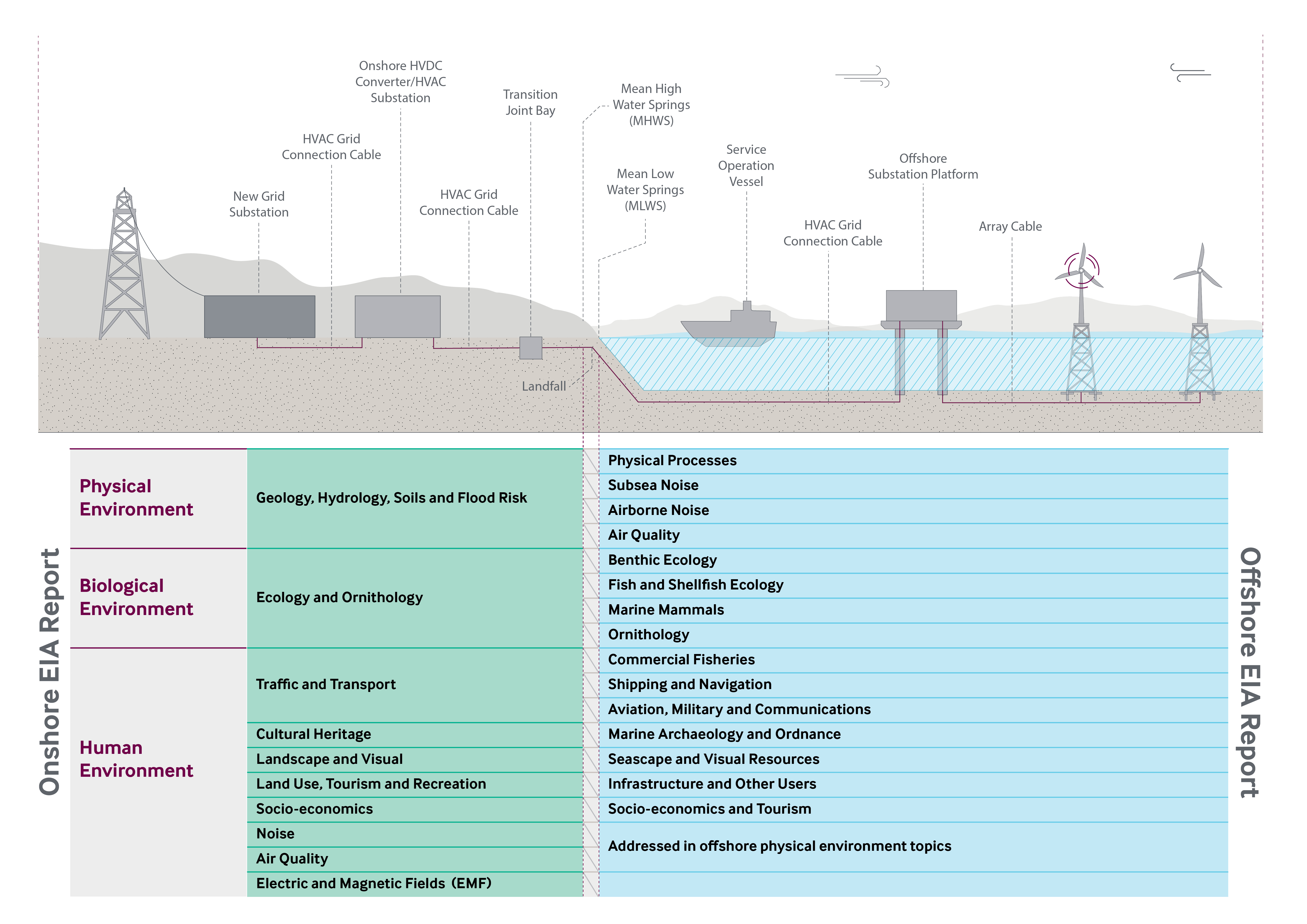
Diagram 1.1 Offshore and Onshore EIA Report Split
1.7. References
1.7. References
1.7. References
- Scottish Executive (1997). The Town and Country Planning (Scotland) Act 1997. Available at: http://www.legislation.gov.uk/ukpga/1997/8/contents
- Scottish Government (2017). The Town and Country Planning (Environmental Impact Assessment) (Scotland) Regulations 2019. Available at: http://www.legislation.gov.uk/ssi/2017/102/contents/made
- EIA SCOPING APPROACH
- Introduction
Introduction
EIA SCOPING APPROACH Introduction
This chapter details how the Applicant has approached the scoping of the EIAR.
2.2. Approach to Scoping
2.2. Approach to Scoping
The Applicant is undertaking a comprehensive site selection process, identifying the most suitable landfall(s), substation and cable route locations from a range of environmental, engineering and land perspectives. The site selection process will be completed following more detailed assessments by the Applicant, due to be undertaken at the time of submission of this Scoping Report. Therefore, this Scoping Report considers the siting of the Proposed Development within the Search Area for the Site Boundary identified on Figure 1.1, including three potential substation locations and two potential landfall options (refer to Chapter 5 for further details).
2.2.1. The Town and Country Planning (Environmental Impact Assessment) (Scotland) Regulations 2017
As per Section 1.5, the Applicant has opted to undertake an EIA on a voluntary basis.
In accordance with Regulation 17(2) the “scoping request” of which this EIA Scoping Report is part includes:
- “a description of the location of the development, including a plan sufficient to identify the land” – identified in Chapter 5 and Figure 1.1;
- “a brief description of the nature and purpose of the development and of its likely significant effects on the environment” – provided in Chapter 6 and Chapters 7-16 of this Scoping Report;
- “such other information or representations as the developer may wish to provide or make”.
In forming a scoping opinion, Regulation 17(5) requires the planning authority to take into account “the information provided by the developer, in particular information provided by the developer in respect of the specific characteristics of the development, including its location and technical capacity and its likely impact on the environment”.
The Applicant has proposed a scope of EIA which is proportionate, reasonable, and takes account of the above mentioned points. This proposed scope is summarised in Chapter 17 of this Scoping Report.
2.2.2. Study Areas
The study areas to be assessed by the technical disciplines are different depending on each discipline and their receptors. However, all are based on the Search Area for the Site Boundary shown in Figure 1.1 As described above, the final site boundary will be within this Search Area and will be confirmed prior to the final EIA assessment of the Proposed Development.
2.2.3. Baseline Environment
To appropriately scope the EIA, each technical discipline has identified their study area. Each technical assessor has described, where possible, their environmental baseline, the characteristics/nature of the receiving environment and receptors. This information has been gathered from desk-studies and publicly available information.
Where there are aspects of the baseline which are unknown, the Scoping Report identifies the surveys and /or studies proposed to be undertaken to provide this information. Although some of these surveys have commenced at the time of the submission, COVID-19 restrictions have meant that the majority of these have not yet commenced.
2.2.4. Assessment
The Applicant is a keen supporter of a proportionate EIA (IEMA, 2017). A proportionate EIA is one which has been scoped to focus on the potential significant adverse environmental effects. It scopes out receptors which would not be impacted by the Proposed Development or impacts which we can confidently predict will not result in significant adverse effects.
2.2.5. Application of Embedded Measures
In order to ensure a proportionate EIA this Scoping Report assumes that a range of mitigation measures will be embedded within the Proposed Development. These mitigation measures will be undertaken by the Applicant, no matter the findings of the EIA, or whether or not the measures are specifically required by the planning permission, and are therefore part of the Proposed Development, rather than in addition to the Proposed Development.
Annex A provides an Outline Schedule of Environmental Commitments (OSEC). This OSEC details all the embedded mitigation measures and will be expanded upon based on the findings of the EIA.
When considering the potential significance of the effects due to the Proposed Development, the EIA Scoping Report takes into consideration the mitigation measures described in the OSEC. Therefore, receptors and impacts are only proposed to be taken forwards for further assessment within the EIA if it is considered that there is potential for significant effects to arise even with the implementation of the OSEC.
2.2.6. Approach to Scoping of Cumulative Impacts
The cumulative assessment of the Proposed Development will be two-tiered:
- Tier 1 - An assessment of the cumulative effects where there is potential for onshore receptors to be affected by the onshore and offshore infrastructure of the Project; and
- Tier 2 - An assessment of the cumulative effects of the Project in combination with other proposed (in planning) and consented developments in the onshore environment.
. As per Scottish Planning Policy (Scottish Government, 2014) only developments which are submitted to planning, consented or under construction will be considered cumulatively. Developments which have not yet submitted a planning application (i.e. developments who are at Scoping or have submitted a Proposal of Application Notice) will not be included within the cumulative assessment due to the lack of certainty over their design and potential environmental effects.
This list of cumulative developments will continually be updated throughout the assessment of the Proposed Development and any exceptional circumstances considered. However, the list will be “frozen” three months prior to the submission of the application to allow assessments to be made and reported within the EIAR.
The Applicant would be grateful if ELC would review this list and confirm if there any additional developments which they are aware of.
2.3. Community Consultation & Stakeholder Engagement
2.3.1. Regulatory Basis to Community Consultation
Since the Proposed Development falls within the scope of National Planning Framework (NPF) 3’s national development number 4, it is afforded national development status in accordance with the Town and Country Planning (Hierarchy of Developments) (Scotland) Regulations 2009. Such status requires applicants to engage with local communities during a formal pre-application consultation process triggered by the submission of a Proposal of Application Notice to the relevant planning authority. That pre-application process must then be documented within a Consultation Statement which forms part of the suite of planning application documentation. The Applicant confirms that these Regulatory obligations will be delivered as part of a comprehensive programme of pre-application consultation programmed for Q4 2020-Q2 2021.
2.3.2. Engagement to Date
The Applicant has undertaken early engagement with statutory consultees, ELC, Scottish Environment Protection Agency (SEPA), Scottish Natural Heritage (SNH) and Historic Environment Scotland (HES). This engagement has taken the form of introductory correspondence to identify the appropriate contact with the organisation and introductory meetings where the Applicant has provided the consultee with an overview of the Proposed Development, the background and the proposed timescales of the application. This has provided consultees with the opportunity to raise queries and provide feedback early in the application process.
Correspondence received from this engagement is provided for reference within Annex B.
2.3.3. Proposed Approach to Engagement
The Applicant proposes to continue to consult throughout the pre-application stage of the Proposed Development, following receipt of consultee comments as part of the EIA Scoping Opinion.
The Applicant’s technical team will contact consultees directly on matters of technical expertise, agreement of surveys, discussion of mitigation, etc. and all consultation will be reported fully within the EIAR.
2.3.4. Public Consultation
The Applicant will undertake a number of public exhibitions on the Project (including the Proposed Development), as well as meeting with the Community Councils to ensure the public is fully informed and that their views are considered in the design of the Proposed Development. If at the time of undertaking public exhibitions there is still a risk posed by COVID-19, then these will be carried out in accordance with relevant legislation, and may be held virtually (Scottish Government, 2020).
Details of the proposed approach to public consultation will be set out in the Pre-Application Notification (PAN) submitted to ELC.
Full details and outcomes of the public engagement will be provided within a Pre-Application Consultation Report which will be submitted in support of the planning application.
2.4. Application and Consenting Process
In defining an appropriate consenting strategy, the Applicant has drawn from a wide range of experience of comparable projects, both in East Lothian and elsewhere. The consenting strategy is underpinned by the Proposed Development’s national development status by way of NPF3’s national development 4, as well as NPF3’s identification of the Torness area as a hub for energy-related investment (refer to Chapter 3 for further details).
The Applicant has considered a series of potential consenting options. Marine Scotland advocates a streamlined “one stop shop” consenting process including ancillary onshore infrastructure associated with offshore generation being consented via a direction for deemed planning permission under S57 of the Town and Country Planning (Scotland) Act 1997 (as amended by the Growth and Infrastructure Act 2013) as part of a single application for consent under Section 36 of the Electricity Act 1989. Whilst the option of a single application for off- and onshore elements of the Project remains available to the Applicant, this is not the option the Applicant is currently proposing.
Instead, as previously discussed it is intended that separate offshore and onshore applications will be made to Marine Scotland and ELC, respectively, the latter being a single application for full planning permission, in accordance with the Town and Country Planning (Scotland) Act 1997. It is currently anticipated that the applications will be made in 2021.
2.5. References
2.5. References
- Institute of Environmental Management and Assessment (IEMA) (2017), Delivering Proportionate EIA – A Collaborative Strategy Enhancing UK Environmental Impact Assessment Practice. Available at: https://www.iema.net/policy/ia/proportionate-eia-guidance-2017.pdf
- Scottish Government (2020), Coronavirus (COVID-19): Planning Guidance of Pre-Application Consultations for Public Events. Available at: https://www.gov.scot/publications/coronavirus-covid-19-planning-guidance-on-pre-application-consultations-for-public-events/
- POLICY & LEGISLATION
- Introduction
Introduction
POLICY & LEGISLATION Introduction
This chapter provides an overview of the policy and legislation context for the Proposed Development. A detailed discussion and evaluation of relevant policies will be included within the Planning Statement which will be submitted in support of the planning application.
3.2. Legislative Context
3.2. Legislative Context
3.2.1. The Town and Country Planning (Scotland) Act 1997 (as amended)
The consenting approach described within Section 2.4 is underpinned by Section 25(1) of the Town and Country Planning (Scotland) Act 1997 (as amended by the Town and Country Planning (Scotland) Act 2019) (Scottish Government, 2019), which states: “Where, in making any determination under the planning Acts, regard is to be had to the development plan, the determination is, unless material considerations indicate otherwise, to be made in accordance with that plan.”
In the case of the Proposed Development, the development plan, the parameters of which are defined by Section 24 of the Town and Country Planning (Scotland) Act 1997 (as amended by the Town and Country Planning (Scotland) Act 2019), comprises:
- NPF3 (Scottish Government, 2014a);
- “SESplan” Strategic Development Plan (The Strategic Development Planning Authority for Edinburgh and South East Scotland, 2013); and
- East Lothian Council Local Development Plan 2018 (East Lothian Council, 2018) (hereafter “the LDP”).
This chapter considers the statutory development plan and relevant other policy-based material considerations, the latter including:
- Emerging development plan policy, specifically:
- NPF4; and
- SESplan 2;
- Scottish planning policy and advice notes; and
- UK and Scottish energy policy.
- National Planning Framework
- NPF3
National Planning Framework NPF3
- National Planning Framework
Section 6 of NPF3 notes that national developments have been defined in recognition of their “need” in the delivery of the Scottish Government’s wider spatial strategy for Scotland. It continues within paragraph 6.1 by specifically noting that “…national development status establishes the need for a project…”.
With the need for national developments clearly established, the remainder of this section demonstrates the applicability of national development status to the Proposed Development, before summarising relevant parts of NPF3.
3.3.1.1. National Development Number 4
NPF3’s national development 4 relates to the high voltage electricity transmission network, specifically:
“a. new and/or upgraded onshore electricity transmission cabling of or in excess of 132 kilovolts, and supporting pylons.
b. new and/or upgraded onshore sub stations directly linked to electricity transmission cabling of or in excess of 132 kilovolts.
c. new and/or upgraded onshore converter stations directly linked to onshore and/or offshore electricity transmission cable(s) of or in excess of 132 kilovolts.
d. new and/or upgraded offshore electricity transmission cabling of or exceeding 132 kilovolts.”
Annex A to NPF3 confirms that planning applications for development within one or more classes listed in the aforementioned points a-d is designated as “national” for the purpose of the Section 26A of the Town and Country Planning (Scotland) Act 1997 (as amended) and the associated Town and Country Planning (Hierarchy of Developments) (Scotland) 2009.
In describing national development designations, Annex A to NPF3 includes the following statement of need in respect of national development number 4:
“These classes of development are needed to support the delivery of an enhanced high voltage electricity transmission grid which is vital in meeting national targets for electricity generation, statutory climate change targets, and security of energy supplies.”
The Proposed Development falls within the scope of national development number 4 by way of relating to:
- New onshore electricity transmission cabling in excess of 132 kilovolts (kV); and
- A new onshore substation directly linked to such cables (i.e. consistent with the aforementioned paragraph b).
As such, the Proposed Development will, in the forthcoming planning application, be afforded national development status.
3.3.1.2. Torness Area
The strategic importance of the Torness area is recognised elsewhere in NPF3:
- On page 14: “The Fife Energy Corridor, which extends from Methil to Longannet, has potential for significant investment in energy-related business development, as do the Cockenzie and Torness areas in East Lothian”;
- On page 29: as part of the area of East Lothian illustrated as being subject to the “High Voltage Energy (sic) Transmission Network” national development designation; and
- On page 39: “Cockenzie, and the Forth coast extending to Torness, is also a potentially important energy hub. There are significant plans for offshore wind to the east of the Firths of Forth and Tay. Proposals for grid connections for these projects are now emerging, requiring undersea cabling connecting with converter stations and substations…”
- NPF4
Given its relative infancy following the 30 April completion of the Scottish Government’s “Call for Ideas” process, the emerging NPF4 is of very limited weight at this stage. However, preparation of NPF4 is likely to have progressed by the anticipated time of planning application submission; it will be appropriately referenced and relevant weight will be applied to its content.
The Applicant has engaged in the NPF4 Call for Ideas process, recommending and requesting continued national development status for transmission-scale electricity infrastructure proposals, as well as continued recognition of the strategic importance of the Torness area as part of East Lothian’s energy coast.
3.4. Other Extant and Emerging Development Plan Policy
3.4.1. Strategic Development Plan
3.4.1.1. Status of Extant and Emerging Strategic Development Plans
As referenced above, SESplan retains status as part of the statutory development plan. However, SESplan is aged and pre-dates the approval of NPF3. Given the advanced stage of its successor, “SESplan2”, SESplan is considered to be of limited weight in respect of applications for national developments defined by NPF3. Further, it is likely that SESplan2 will have been formally adopted by summer 2021, removing any residual relevance of SESplan. As such, SESplan is not considered further and SESplan2 is considered from a strategic development planning perspective.
3.4.1.2. SESplan2
SESplan2 has reached an advanced stage in its preparation, having been submitted to Ministers for approval following the July 2018 conclusion of an examination process. Whilst the submission was rejected by Ministers, the reasons for that rejection are of no relevance to the Proposed Development. As such, SESplan2, as it relates to matters of relevance to the Proposed Development, can be considered acceptable to Ministers. SESplan2 can therefore be considered representative of up-to-date strategic policy in respect of the Proposed Development, and significant weight can be attached to the Proposed SESplan2 (October 2016), incorporating the findings of Scottish Government Reporters, dated 20 July 2018.
Parts of relevance to the Proposed Development are outlined below, from SESplan2’s commentary on “A Low Carbon Economy”:
- Table 4.1: Significant Business Case – Torness identified as part of the “Forth Coast Cluster” a significant cluster area identified primarily for development associated with energy and port uses: “Cluster of coastal sites providing opportunities for a range of uses [including]…low carbon energy generation or other uses associated with Area of Coordinated Action…”; and
- In considering Table 4.1, Reporters consider that: “…the description of the principal sectors and opportunities associated with the Forth Coast Cluster within the proposed plan would encompass supporting infrastructure including cables and substations for major offshore wind farm developments…”.
Although not in the form of specific policies, SESplan2 also compels planning authorities, through development planning processes (as opposed to from a development management perspective), to provide sufficient protections for the natural environment, protected cultural heritage features and local communities, as well as ensuring sufficient infrastructure is placed to deliver sustainable development.
3.4.2. The LDP
LDP policy can be considered in three parts:
- site specific policies;
- policies relevant given the nature of the Proposed Development; and
- general LDP policies.
Within the supporting documentation which will accompany the planning application, policies within parts 1 and 2 above will be addressed within the supporting Planning Statement, and generally relate to the principle of the Proposed Development, whilst for those within part 3 above, forms part of the technical EIA assessment. LDP policies are outlined on these three bases, below.
3.4.2.1. Site Specific Policies
The Search Area for the Site Boundary (as described within Section 5.2) includes areas covered by the policy designations referenced within Table 3.1.
Table 3.1: Policy Designations
As previously noted, the Search Area for the Site Boundary will be refined through further design work and it may be that some of the designations are not relevant to the final form of the Proposed Development which progressed to planning application stage. Relevant site specific policies will be considered within the Planning Statement which accompanies the planning application and will form part of the detailed assessment within the relevant EIAR technical chapter.
3.4.2.2. Policies Relevant Specifically to the Proposed Development
In addition to relevant site specific policies, a small number of LDP policies are specific to proposals of character similar to the Proposed Development:
- Policy EGT4: Enhanced High Voltage Electricity Transmission Network.
Policy EGT4 outlines ELC support for development within the scope of NPF3’s national development number 4, subject to acceptable impacts on:
- landscape;
- visual amenity;
- communities;
- natural heritage; and
- cultural heritage.
Policy NGT4 also references Strategy Diagram 3, which illustrates the area of co-ordinated action and identifies “potential electricity grid connection” nearby Torness, as well as the Branxton sealing end compound within the area of co-ordinated action.
3.4.2.3. General LDP Policies
Of the LDP policies which are theoretically relevant to all planning applications, those referenced in Table 3.2 are relevant, or potentially could be relevant, to the consideration of the Proposed Development.
Table 3.2: Relevant LDP Policies
Relevant policies will form part of the assessment of the Proposed Development within the relevant EIAR technical chapter.
3.5. Other Policy-Based Material Considerations
3.5.1. Scottish Energy Policy
3.5.1.1. Scotland’s Emission Reduction Targets
The Climate Change (Emissions Reduction Targets) (Scotland) Act 2019 (Scottish Government, 2019a) sets targets for the reduction of greenhouse gases emissions. The objective is to contribute appropriately to the world’s efforts to deliver on the Paris Agreement reached at the 21st Conference of the Parties of the United Nations Framework Convention on Climate Change. The Emissions Reduction Targets include a reduction of all greenhouse gases to net-zero by 2045 at the latest, with interim targets for reductions of at least 56% by 2020, 75% by 2030 and 90% by 2040.
3.5.1.2. The Scottish Energy Strategy: The Future of Energy in Scotland
The Scottish Energy Strategy: The Future of Energy in Scotland (Scottish Government, 2017) sets out the Scottish Governments 2050 vision for energy in Scotland. One of the six 2050 vision includes renewable and low carbon solutions, specifically championing and exploring Scotland’s huge renewable energy resources and ability to support energy targets.
3.5.1.3. Draft Sectoral Marine Plan for Offshore Wind Energy
Scotland is committed to ensuring secure, reliable and affordable energy supplies, within the context of long-term decarbonised energy generation. In 2011, the first Sectoral Marine Plan for Offshore Wind Energy (Blue Seas Green Energy) (Marine Scotland, 2011) was adopted. In 2013, draft wind, wave and tidal plans were subsequently produced (Marine Scotland, 2013).
Building upon the work undertaken in the 2011 and 2013 plans, the Draft Sectoral Marine Plan for Offshore Wind Energy (Scottish Government, 2019b) incorporates recent technological, policy, regulatory and market developments to develop a new strategic planning process. This plan seeks to contribute to the achievement of Scottish and UK energy targets through the provision of a spatial strategy to inform the seabed leasing process for commercial offshore wind energy in Scottish waters, which:
- minimises the potential adverse effects on other marine users, economic sectors and the environment resulting from further commercial-scale offshore wind development; and
- maximises opportunities for economic development, investment and employment in Scotland, by identifying new opportunities for commercial scale offshore wind development, including deeper water wind technologies.
This plan identifies 17 draft plan options across five regions which are capable of generating several GW of renewable energy. There is the potential for up to 10 GW to be deployed to reflect the anticipated future demand and market appetite, exceeding the Scottish Offshore Wind Energy Council’s goal to deliver at least 8 GW of offshore wind in Scottish waters by 2030. The final Sectoral Marine Plan for Offshore Wind Energy will guide relevant consenting bodies with decision making on licence and consent applications but will not predetermine decision-making processes.
This plan has been developed in accordance with the strategic aims of the National Marine Plan (Marine Scotland, 2015a), which addresses the potential for interactions between renewable energy development and other marine users. The National Marine Plan also recognises that significant development of the offshore wind energy sector will require investment and improvement to the current electricity transmission and distribution systems, and efforts to reduce barrier connection costs for generators.
3.5.1.4. Draft Offshore Wind Policy Statement
The Draft Offshore Wind Energy Policy Statement (Scottish Government, 2019c) sets out ambitions to capitalise offshore wind development and the role this technology could play in meeting commitments of net zero by 2045, as required by The Climate Change (Emissions Reduction Targets) (Scotland) Act 2019. The Draft Offshore Wind Energy Policy Statement builds upon the ambitions outlined in Scotland’s Energy Strategy (Scottish Government, 2017), which sets out the 2050 energy vision. Scotland’s Energy Strategy forms a key component of the implementation of The Draft Offshore Wind Energy Policy Statement through the identification of suitable offshore wind farm development areas. The Draft Offshore Wind Energy Policy Statement is currently undergoing consultation and will be finalised in 2020.
3.5.2. Scottish Planning Policy and Advice Notes
Relevant sections of Scottish Planning Policy (SPP) (June 2014b) and relevant Planning Advice Notes (PANs) are summarised in Table 3.3, below, and are documented in respect of relevant environmental topics. Technical assessment of those environmental topics which are “scoped-in” to the EIA process will include consideration of the relevant parts of SPP and PANs.
Table 3.3: Summary of SPP and PANs
At paragraph 169, SPP sets out likely considerations to be taken into account in the determination of applications for renewable energy-related infrastructure. It acknowledges that the scope of considerations will be specific to the characteristics of specific proposals. Considerations of relevance to the Proposed Development are referenced within Table 3.3.
In addition to the topic specific PANs referenced in Table 3.3, PAN 1/2013: Environmental Impact Assessment (Scottish Government, 2013) is relevant to the forthcoming planning application, albeit elements are effectively outdated following the publication of the 2017 EIA Regulations.
3.6. The Need for the Proposed Development
The need for the Proposed Development can be considered from two perspectives: (i) the policy-based need for the Proposed Development; (ii) the practical need for the Proposed Development. Each perspective is considered, below.
3.6.1. The Policy-Based Need for the Proposed Development
As documented in Section 3.2 of this Scoping Report, by falling within the scope of NPF3’s national development number 4, the need for the Proposed Development is established in the context of Scottish planning policy. This is recognised in ELC LDP policy.
In the context of the wider Scottish and UK energy policy discussed within Section 3.5 of this Scoping Report, the need for the Project, focussed upon the role of offshore wind energy as part of a sustainable long-term mix of generating sources across Scotland and the UK, is established. The Project will contribute towards Scotland’s climate change targets, specifically 2045 net-zero targets.
3.6.2. The Practical Need for the Proposed Development
As part of the Project, the policy-based need for the Proposed Development is established, and therefore, the practical need for the Proposed Development is clear.
The Proposed Development is needed to connect a major offshore wind electricity generating facility to the national electricity transmission grid. Without such a connection the electricity generated offshore could not connect to the grid and in turn, could not be used to power residential, commercial and other properties across East Lothian, Scotland and the UK.
3.7. References
3.7. References
- East Lothian Council (2018). Local Development Plan. Available at: https://www.eastlothian.gov.uk/info/210547/planning_and_building_standards/12242/local_development_plan/2
- Marine Scotland (2011). Sectoral Marine Plan for Offshore Wind Energy (Blue Seas Green Energy). Available at: https://www2.gov.scot/Topics/marine/marineenergy/wind
- Marine Scotland (2015). National Marine Plan. Available at: https://www.gov.scot/publications/scotlands-national-marine-plan/
- Scottish Executive (1997). Town and Country Planning (Scotland) Act 1997 (as amended by the Town and Country Planning (Scotland) Act 2019). Available at: http://www.legislation.gov.uk/ukpga/1997/8/contents
- Scottish Government (2014a). National Planning Framework 3. Available at: https://www2.gov.scot/Topics/Built-Environment/planning/NPF3-SPP-Review/NPF3
- Scottish Government (2014b). Scottish Planning Policy. Available at: https://www.gov.scot/publications/scottish-planning-policy/
- Scottish Government (2017). The Scottish Energy Strategy: The Future of Energy in Scotland. Available at: https://www.gov.scot/publications/scottish-energy-strategy-future-energy-scotland-9781788515276/
- Scottish Government (2019b). Draft Sectoral Marine Plan for Offshore Wind Scottish Government (2019a). The Climate Change (Emissions Reduction Targets) (Scotland) Act 2019. Available at: http://www.legislation.gov.uk/asp/2019/15/enactedEnergy. Available at: https://www2.gov.scot/Topics/marine/marineenergy/Planning/draftSMPcons2019
- Scottish Government (2019c). The Draft Offshore Wind Energy Policy Statement. Available at: https://www.gov.scot/publications/draft-offshore-wind-policy-statement/
- Scottish Government (various). Planning Advice Notes. Available at: https://www.gov.scot/collections/planning-advice-notes-pans/
- The Strategic Development Planning Authority for Edinburgh and South East Scotland (2013). Strategic Development Plan. Available at: https://www.sesplan.gov.uk/assets/files/docs/290813/SESplan%20Strategic%20Development%20Plan%20Approved%2027%20June%202013.pdf
- OVERVIEW OF SITE SELECTION PROCESS
- Introduction
Introduction
OVERVIEW OF SITE SELECTION PROCESS Introduction
The Applicant has a grid connection agreement with National Grid Electricity System Operator at a point close to the existing Branxton compound, approximately 8 km south of Dunbar.
From this, the Applicant has considered a number of landfall and substation options within the vicinity of Branxton. These have been evaluated from an engineering, consents (planning and environment), land use and cost perspective.
4.2. Site Selection
4.2. Site Selection
The following process has been followed to identify the key infrastructure sites currently being considered within the Search Area for the Site Boundary:

Diagram 4.1: Site Selection Process Overview
Note that reference to landfall 3 is the Skateraw landfall option, landfall 5 is the Thorntonloch landfall option, substation 3 is the Thorntonloch Holdings substation option, substation 8 is the Skateraw substation option and substation 9 is the Crowhill substation option.
The preferred indicative options, shown on Figure 5.1 and further detailed in Chapter 5 below, will continue to be refined as part of the iterative design process of the Proposed Development.
- PROPOSED DEVELOPMENT DESCRIPTION
- Introduction
Introduction
PROPOSED DEVELOPMENT DESCRIPTION Introduction
This chapter provides a description of the Search Area for the Site Boundary and its geographical context, and also presents a description of the Proposed Development.
As per Section 1.4, the Proposed Development consists of the onshore infrastructure of the Project down to MLWS.
5.2. Search Area for the Site Boundary
The Search Area for the Site Boundary is situated near Torness and the village of Innerwick, south-east of Dunbar located in East Lothian, Scotland (refer to Figure 1.1). The centre of the site boundary is OSGB36, British National Grid (BNG) 373976, 674081. The site is approximately 678.9 ha in size. It should be noted that the final Planning Application Boundary will be smaller than that shown in Figure 1.1 as it will be refined through further investigations and design evolution processes.
The site runs from the hamlet of Branxton in the south, Bilsdean in the south-east, the coastline at Thorntonloch and Torness in the north-east, Oxwell Mains Cement Works and Quarry and the coastline at Chapel Point in the north, and Fouracres in the west. The area is predominantly agricultural land with sparse hamlets and villages spread throughout the area connected by small local roads and tracks. The A1 trunk road and East Coast Main Line (ECML) railway cut through the centre of the site in a north-west to south-east direction running parallel to the coast. The Torness Nuclear Power Station is located to the north-east of the site, between the two points where the Search Area for the Site Boundary meets the North Sea.
Ground levels within the site vary due to the sloping topography (west to east) and due to deeply incised glacial outwash valleys.
The main existing infrastructure within the site and adjacent area is:
- Torness Nuclear Power Station and associated infrastructure (jetties, outfalls and cables);
- Torness nuclear waste railway loading dock;
- A1 trunk road;
- ECML railway;
- the two existing cable sealing end compounds at Branxton;
- existing 400 kV Overhead Lines and Underground Cables at Branxton
- Innerwick electricity substation associated with the ECML railway; and
- utilities, including water, gas and electricity services.
Chapter 4 provides a summary of the collaborative engineering and environmental consideration which have informed the site selection process and the potential options the Applicant is currently investigating.
5.3. Proposed Development
5.3. Proposed Development
The Proposed Development comprises the onshore elements of the Project, and consists of the following;
- up to two landfall locations and transition pits;
- a new wind farm onshore substation;
- the connecting primarily underground onshore cables (between landfall(s) and the new substation and between the new substation and the grid connection substation) with the option of a short section of OHL and cable bridge (which may be the subject of a separate application under the appropriate legislation);
- potential new and upgraded access tracks to the substation, cable construction corridor and landfall(s); and
- associated ancillary infrastructure.
The lifetime of the Proposed Development is currently anticipated to be 50 years from the commencement of operation to commencement of decommissioning.
5.3.1. Landfalls and Transition Pits
A landfall is where the offshore (sub-marine) export cables come to shore and are connected to the onshore cables at a buried transition pit. The Proposed Development will either have one transition pit for each cable or one large transition pit for all cables. The transition pit(s) will comprise a box-like structure where the cables will be buried. The dimensions of the transition pits will be determined following more detailed assessment.
5.3.1.1. Landfall Options
The Applicant is currently considering two different landfall options, one or both will be used to land the cables from the offshore infrastructure (refer to Figure 5.1):
- Landfall 3 (hereafter referred to as Skateraw landfall option) – BNG 373619, 675786; and
- Landfall 5 (hereafter referred to as Thorntonloch landfall option) – BNG 375457, 673893
Skateraw landfall option is located near Skateraw at Chapel Point, north-west of Torness Power Station. This area is mainly rocky shore, with small areas of sand. The landfall would intersect the Barns Ness Coast Geological Site of Special Scientific Interest (SSSI) and the John Muir Link coastal path.
From the landfall the cable would be routed underground through an area of relatively flat agricultural land to the transition pit, located approximately 170 m north-west of Skateraw harbour and then onto the substation.
Thorntonloch landfall option is located on Thorntonloch beach, south of Torness Power Station. This area is sandy beach and is designated as ‘bathing waters’ by SEPA. The John Muir Link coastal path would also be intersected by Thorntonloch landfall option.
From the landfall the cable would be routed underground through an area of agricultural land located on a gentle, north-eastern facing slope between Thorntonloch beach and the A1 trunk road to the transition pit and then onto the substation. The transition pit would be located approximately 500 m south-east of Thorntonloch on land used for arable agriculture.
In respect of both landfalls, the cable route option beyond the transition pits will depend on the final substation site selection.
5.3.2. Substation
The onshore substation will either be a High Voltage Alternating Current (HVAC) Substation comprising of external HV equipment and Gas Insulated Switchgear; or a High Voltage Direct Current (HVDC) substation comprising of a converter building, HV external equipment and Gas Insulated Switchgear. For the remainder of this EIA Scoping Report the generic term “substation” is used to cover both scenarios. The substation will contain electrical components for transforming the power supplied from the wind farm to the grid voltage.
The footprint of the substation infrastructure is anticipated to be approximately 360 m (length) by 250 m (width) by 20 m (height – 26 m including aerials and lightening conductors). The substation will include, but is not limited to, transformers, switchgear, coolers, harmonic filters, reactive power compensation equipment, common building, Gas Insulated Switchgear (GIS) building (if selected), Converter Hall (if HVDC is selected) blast walls, industrial low voltage systems, heating, ventilation and air conditioning. The equipment will be both housed inside buildings and located outside. The configuration of buildings and external equipment (worst case) will be defined within the planning application in order to facilitate assessment of the Proposed Development; however, the final specifications will be the subject of a planning condition, to be approved by ELC prior to the commencement of substation structures.
In addition to the aforementioned substation infrastructure, it is anticipated that there will be landscaping, security fencing, car parking and drainage in the land around the substation.
5.3.2.1. Substation Options
The Applicant is currently considering three potential substation locations, from which one option will be progressed:
- Substation 3 (hereafter referred to as Thorntonloch Holdings substation option): BNG 374586, 673725
- Substation 8 (hereafter referred to as Skateraw substation option): BNG 373348, 674627
- Substation 9 (hereafter referred to as Crowhill substation option): BNG 373748, 674392
Thorntonloch Holdings substation option is located in an agricultural field, on a north-eastern facing slope approximately 650 m south-east of Thorntonloch and 400 m north-east of Thornton (refer to Figure 5.1). The land is currently used for arable agriculture. The ECML railway is located 135 m to the north and the A1 trunk road and NCR76 are located approximately 420 m to the north-east.
Skateraw substation option is located on an agricultural field, at the bottom of a gentle north-eastern facing slope approximately 350 m south of Skateraw, and 380 m north of Crowhill (refer to Figure 5.1). The land is currently used for arable agriculture. The ECML railway is located 80 m to the north-east and the A1 trunk road 150 m to the north.
Crowhill substation option is located in an agricultural field, on a gentle north-eastern facing slope approximately 550 m south-east of Skateraw, and 180 m north of Crowhill (refer to Figure 5.1). The land is currently used for arable agriculture. The ECML railway is located 110 m to the north and the A1 trunk road are located approximately 280 m to the north. There is also an existing small substation, operated by Scottish Power Energy Networks and Network Rail, 110 m east of Crowhill substation option.
5.3.3. Access Roads
Permanent, surfaced single carriageway roads with passing places, to connect the substation to the public highway will be constructed. These will be private and include appropriate drainage.
In addition, some sections of the public roads may require permanent widening, resurfacing or passing places added to allow access to the Proposed Development site. Any proposed road works will be agreed with ELC.
5.3.4. Onshore Cable Routes
Various options to connect the transition pit(s) to the substation, and the substation to the grid connection point (a new Scottish Power Energy Networks substation being progressed under a separate consenting process) are being considered. The preferred route will be selected following the determination of the substation, landfall location(s), requirements of grid connection, and the undertaking of more detailed investigations.
The cable route from landfall(s) to the substation will intersect the A1 trunk road and ECML railway. Here, trenchless techniques will be employed (refer to below).
Based on the preferred substation, the cable route from the new substation to the substation grid connection will intersect with Thornton Burn.
The proposed cable route will be underground, however a short section of OHL and a cable bridge may be required.
5.3.5. Drainage
Permanent drainage may be required for the substation site and along the cable route. The design and locations of this will be developed as the Proposed Development progresses and will meet national standards and guidance.
5.4. Construction Phase
5.4. Construction Phase
Construction of the Proposed Development is anticipated to take approximately 36 months, commencing in 2025, following consent in 2022. The exact construction methodologies for the permanent infrastructure are yet to be determined, however potential options are described below. The design and the construction methodology (including required temporary infrastructure) will be determined in advance of the planning application submission and included in the EIAR.
The EIAR will include appropriate assumptions in respect of construction phasing. A detailed construction phasing plan will be submitted for ELC approval pursuant to a planning condition and may include:
- Landfall(s);
- Cable enabling works;
- Cable route construction;
- If required, cable bridge and OHL construction;
- Substation enabling works;
- Substation civils works;
- Substation structural works. and [2]
- Substation electrical installation works
Discharge of planning conditions will relate to agreed phases of construction.
Normal construction hours will be Monday to Sunday 07.00-19.00.
If these times require to be controlled this will be agreed with ELC via an appropriately worded condition. Details of the construction programme will be provided to ELC in the Construction Environmental Management Plan (CEMP) prior to the commencement of construction and secured via an appropriately worded planning condition.
Any construction outwith these hours, due to construction time constraints (e.g. specific works are required to be undertaken within one session), weather windows and/or health and safety requirements, will be in line with the noise limits and advance warning of any works outwith the normal working hours will be provided to ELC Environmental Services and local residents.
5.4.1. Construction Environmental Management Plan (CEMP)
As part of the construction contract, the Applicant and their Contractor will develop, and adhere to, a CEMP which will cover all aspects of the Proposed Development and describe how the Contractor will ensure the suitable implementation and control of the mitigation measures described in the EIAR.
5.4.2. Landfalls and Transition Pits
5.4.2.1. Methodology
The offshore cable will be brought to shore using trenchless technology or open cut trenching (refer to the Glossary). The offshore cable will be pulled from sea to land, while the drill, or trench, will be constructed from land to sea.
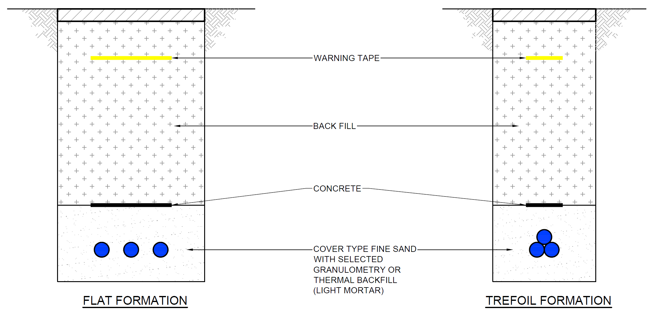
Drawing 5.1: Typical Cross-Section of Open Trenching Method
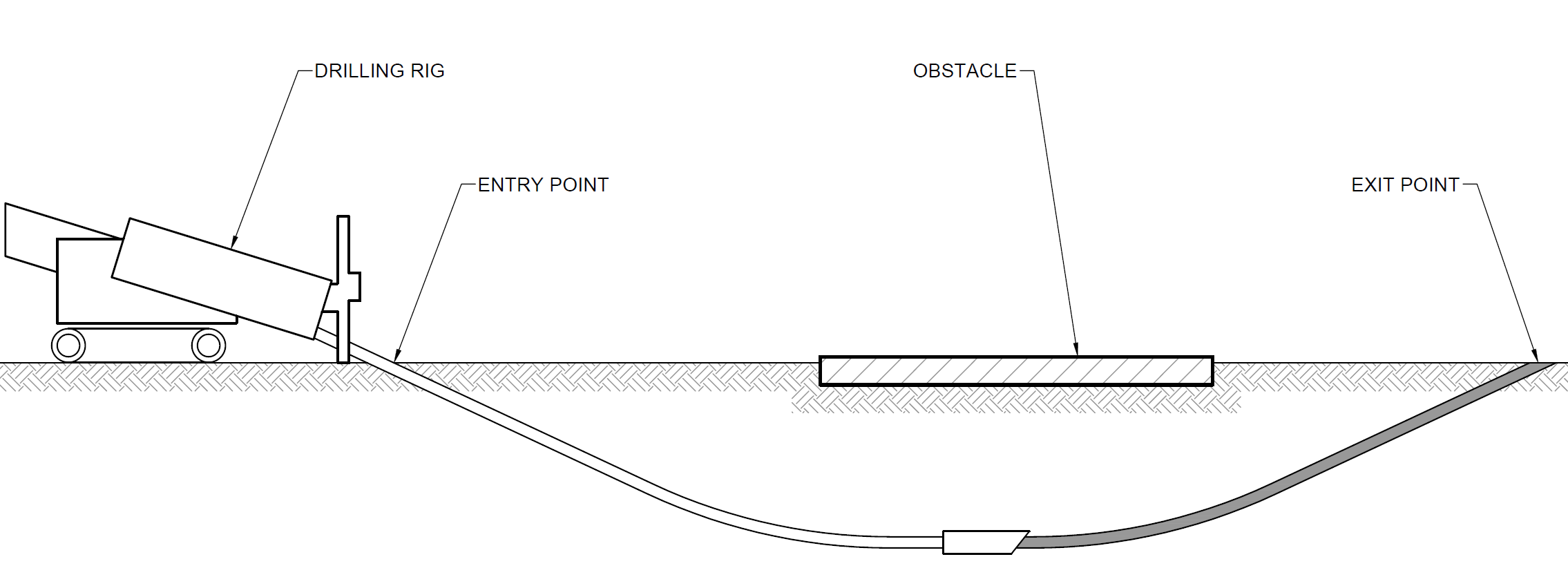
Drawing 5.2: Typical Long-Section of HDD Method[3]
The transition pit(s) will be dug using the same methodology as open cut trenching. Following construction and installation, the transition pit(s) will be back-filled with only minor structures being visible above ground such as a low link pillar for earthing requirements and potentially fencing. Other smaller excavations in the vicinity may also be necessary for fibre optic link joints and earthing requirements.
5.4.2.2. Temporary Infrastructure
During construction a temporary welfare and construction compound will require to be built adjacent to the transition pit(s). The size of the construction compound is not yet known and will depend upon the construction methodology but may range from 4,000-10,000 m2.
Temporary access tracks to the landfall and transition pit(s) may be required to be built to connect the landfall and transition pit(s) to the public highway.
5.4.3. Substation
5.4.3.1. Methodology
The construction of the substation is anticipated to require the following:
- Construction of spread foundations to support small structures and pavements including car parking;
- Construction of piled foundations to support the high loads of the transformers;
- Construction of a flat platform. The exact depth and volume of cut and fill will be determined following more detailed investigations. Depending on the topography this may require the construction of retaining structures;
- Installation of utilities and services;
- Installation of drainage and construction of attenuation pond;
- Installation of substation infrastructure; and
- Landscaping, fencing and restoration of site.
- Temporary Infrastructure
It is anticipated that a construction compound of similar sizing to the substation will be required nearby to the substation during construction. It will generally include welfare facilities, portacabin office(s), plant and equipment, laydown areas, and car parking.
5.4.4. Access Tracks
5.4.4.1. Methodology
Sections of existing roads may require widening, specifically on bends and require passing laybys, or resurfacing. Where possible impacts to trees and hedgerows along existing roads will be minimised. The selection of these roads and the dimensions for widening/upgrading will be developed prior to submission of the application. The upgrading of temporary and permanent access roads will be carried out to an acceptable standard to accommodate abnormal load delivery vehicles.
5.4.4.2. Temporary Infrastructure
Temporary borrow pit(s) may be required to provide aggregate for the construction of the substation and access roads. The requirement for borrow pit(s), their location, and their method of excavation will be determined through more detailed investigations and reported within the EIAR. Land affected by temporary works will be reinstated upon completion of such works.
5.4.5. Onshore Cables
5.4.5.1. Methodology
Open cut trenching will be required for the majority of onshore cable route installation with trenchless technology being considered for landfall, to cross infrastructure such as underground cables, the A1 trunk road and ECML railway (refer to the Glossary). The preferred technique(s) will be determined through more detailed investigations.
There is also potentially a requirement for piled foundations to support bridge crossings of watercourses and OHL, if such structures are required.
5.4.5.2. Temporary Infrastructure
Depending on the cable route there is potential for several small construction compounds to be located along the cable route.
5.4.6. Drainage
During construction temporary Sustainable Urban Drainage Systems (SUDS) will be constructed around the temporary infrastructure (access tracks and construction compounds) to manage and control surface run-off.
Prior to commencement of construction activities, a pollution prevention plan, part of a Construction Site Licence, will be approved by SEPA to ensure that appropriate measures are put in place to protect watercourses and the surrounding environment.
5.4.7. Water Abstraction
As well as water being tanked into the Proposed Development site for use during construction, water may also be obtained from the site e.g. pumped from boreholes. If water is to be abstracted from the site for use in construction the Applicant will provide an assessment of this within the EIAR and submit appropriate Controlled Activities Regulations (CAR) applications to SEPA.
5.5. Operation & Maintenance Phase
The Proposed Development will be managed, operated and maintained initially by Berwick Bank Wind Limited and then Offshore Transmission Owners for the duration of its lifetime, currently anticipated at 50 years.
During operation access will be required to the Proposed Development for operation and maintenance activities 24 hours per day, 365 days per year, however the Proposed Development will not be permanently staffed.
Security at the substation during operation will comprise likely appropriate fencing, CCTV and access control systems. It is anticipated that fencing may also be required at the transition joint bays along the cable route.
5.6. Decommissioning Phase
For the purpose of the EIA the Applicant assumes that the decommissioning will occur 50 years after the commencement of operation and will take 18-24 months to complete.
The methodology for decommissioning will be similar to that described above for construction, but in reverse. It is anticipated that all the infrastructure will be removed with the exception of buried ducting, the foundations of the substation and any bridge crossings outwith the top 1 m of the reinstated surface level. It is anticipated that a Decommissioning Plan will be required by a planning condition, to be approved by ELC prior to the commencement of decommissioning activities.
- ENVIRONMENTAL IMPACT ASSESSMENT METHODOLOGY
- Introduction
Introduction
ENVIRONMENTAL IMPACT ASSESSMENT METHODOLOGY Introduction
This chapter describes the general methodology that will be applied to the Proposed Development EIA for the identification and evaluation of potential likely significant environmental effects (as defined in the 2017 EIA Regulations) and presents the proposed methodology for the identification and evaluation of potential cumulative and inter-related impacts. A systematic and auditable evidence-based approach will be followed to evaluate and interpret the potential effects on physical, biological and human receptors.
This methodology may alter slightly between technical topics due to topic specific best-practice EIA guidance (for example by the Landscape Institute or the Chartered Institute of Ecology and Environmental Management), however the fundamental principles will remain the same. Within the EIAR each technical chapter will provide a detailed methodology of how their assessment has been undertaken.
6.2. Regulations & Guidance
The EU Directive on the assessment of the effects of certain public and private projects on the environment (EIA Directive) (2011/92/EU, as amended by Directive 2014/52/EU) states that when applying for Section 36 consent, a marine licence or planning permission, an EIAR is required to be prepared and submitted to support these applications if they are likely to have a significant effect on the environment due to factors such as their size nature or location.
The Town and Country Planning (Environmental Impact Assessment) (Scotland) Regulations 2017 apply the EIA Directive in a local context.
As per Section 1.5, the Applicant is voluntarily undertaking an EIA as the Applicant accepts that an EIA is required for the Proposed Development.
In addition to the legislative requirements, guidance and best practice documents have been developed to assist with the production of a ‘fit for purpose’ and proportionate EIA. Topic specific documents are detailed in technical Chapters 7-16, while overarching EIA guidance documents are listed below:
- IEMA Environmental Impact Assessment Guide to Shaping Quality Development (IEMA, 2015);
- Delivering Proportionate EIA, A Collaborative Strategy for Enhancing UK Environmental Impact Assessment Practice (IEMA, 2016);
- Planning Advice Note (PAN) 1/2013 Environmental Impact Assessment (Scottish Government, 2017);
- A Handbook on Environmental Impact Assessment (SNH, 2018).
- EIA Process
EIA Process
EIA is an iterative process and through the identification of environmental receptors and the assessment of potential impacts, it influences the design of the Proposed Development. It can also influence the proposed construction, operation and decommissioning methodologies to ensure the environmental impacts of the Proposed Development are removed or reduced, where appropriate.
To achieve this, and to ensure a proportionate EIA, mitigation is classified into three types:
- Primary – mitigation which is part of the proposed development’s design;
- Secondary – mitigation which requires further activity, identified through the EIA process, e.g. implementation through the CEMP or planning conditions; and
- Tertiary – mitigation which will be implemented regardless of the design process and the EIA, i.e. the mitigation outlined in Annex A of this Scoping Report and which will also be included within the CEMP
The application of these in the EIA process is demonstrated in Diagram 6.1.

Diagram 6.1: The Approach to Mitigation within the EIA Process
Diagram 6.1: The Approach to Mitigation within the EIA Process
6.3.1. Characterisation of the Environmental Receptors (the Baseline)
The baseline environmental receptors for each technical topic will be determined through consultation and a range of desk-based research and site surveys.
Following the identification of the environmental receptors their sensitivity will be identified. The methodology for determining sensitivity will differ between technical topics and will be based on a number of factors which may include (depending on the topic):
- statutory or non-statutory designation;
- prevalence;
- vulnerability; and
- usage.
- Identification of Tertiary Mitigation
As per Section 2.2, to ensure a proportionate EIA this Scoping Report, and the EIAR will assume that a range of mitigation measures will be embedded within the Proposed Development. These mitigation measures will be undertaken by the Applicant, no matter the findings of the EIA, or whether or not the measures are specifically required by the planning permission, and are therefore part of the Proposed Development, rather than in addition to the Proposed Development. Implementation of these mitigation measures will be controlled through a planning condition linking the approved development to the EIAR.
Annex A provides an Outline Schedule of Environmental Commitments (OSEC). This OSEC details all the tertiary mitigation measures and will be expanded upon within the EIA following the assessment with any additional specific mitigation measures.
6.3.3. Assessment of Potential Effects
As per Section 2.2, throughout the EIAR a distinction will be made between the term ‘impact’ and ‘effect’. An impact is defined as the likely change to the characteristics/nature of the receiving environment (the ‘receptor’), whereas the ‘effect’ relates to the significance of the impact. The level of significance of effect is determined by considering both the value of the receptor (its ’sensitivity’) and the magnitude of the impact.
The exception to this is the Landscape and Visual Impact Assessment which classifies the level of physical and perceptual change to the receiving environment as the ‘magnitude of change’ in line with the recommendations of the Guidelines for Landscape and Visual Impact Assessment third edition (GLVIA3) (Landscape Institute, 2013). However, this terminology should be considered interchangeable with ’’magnitude of impact’.
Within the EIAR, the assessment of effects for each environmental topic will take into account the environmental impacts of both the construction/decommissioning and operational phases of the Proposed Development and the environmental impacts should the Proposed Development not be consented (the do-nothing scenario).
To determine whether or not the potential effects of the Proposed Development are likely to be ‘significant’ a number of criteria are used. These significance criteria vary between topics but generally include:
- international, national and local designations or standards;
- relationship with planning policy;
- sensitivity of the receiving environment;
- magnitude of impact;
- reversibility and duration of the impact; and
- inter-relationship between impacts.
Effects that are considered to be significant, prior to secondary mitigation but following the implementation of best practice (tertiary mitigation), are identified within the EIAR. The significance attributed to the resultant effect is informed by professional judgement, as to the sensitivity of the affected receptor(s) and the nature and magnitude of the predicted changes/impacts. For example, a major adverse change/impact on a feature or site of low importance will have an effect of lesser significance than the same impact on a feature or site of high importance. Table 6.1 below is used as a guide to the relationship between the sensitivity of the identified receptor and the anticipated magnitude of an impact/change. Professional judgement is however equally important in establishing the suitability of this guiding ‘formula’ to the assessment of the significance of each individual effect.
Table 6.1: Significance of Effects Matrix
The following terms are used in the EIAR, unless otherwise stated, to determine the level of effects predicted to occur:
- major beneficial or adverse effect – where the Proposed Development would result in a significant improvement (or deterioration) to the existing environment;
- moderate beneficial or adverse effect – where the Proposed Development would result in a noticeable improvement (or deterioration) to the existing environment;
- minor beneficial or adverse effect – where the Proposed Development would result in a small improvement (or deterioration) to the existing environment; and
- negligible – where the Proposed Development would result in no discernible improvement (or deterioration) to the existing environment.
Using professional judgement and with reference to the Guidelines for Environmental Impact Assessment (IEMA, 2004), the majority of the assessments within this EIAR consider effects of moderate or major to be significant (those highlighted orange to red within Table 6.1). Those of minor or negligible effect are deemed to be non-significant (yellow, green and white within Table 6.1). Professional judgement will be used to determine whether an effect of minor-moderate significance is considered significant or non-significant. If there are deviations from this these will be clearly stated within the individual technical chapters.
Summary tables that outline the predicted effects associated with an environmental topic, will be provided at the end of each technical chapter of the EIAR. Distinction will also be made between direct and indirect, short and long term, permanent and temporary, beneficial and adverse effects.
6.3.4. Identification of Primary Mitigation
Primary mitigation alters the design of the Proposed Development, or associated construction, operation or decommissioning methodologies in order to reduce or remove the potential significant effects. Primary mitigation is an intrinsic part of the design of the Proposed Development and as such will be reported within the Design Chapter of the EIAR.
6.3.5. Identification of Secondary Mitigation
Should significant effects be identified which cannot be mitigated through the implementation of the primary or tertiary mitigation, secondary mitigation will be identified to further remove/reduce the significant adverse effects. In addition, should environmental monitoring measures be required during the Proposed Developments lifecycle, these will be detailed here.
This secondary mitigation, along with the tertiary mitigation will be compiled within a Schedule of Mitigation within the EIAR and the Applicant will commit to implementing these mitigation measures.
6.3.6. Assessment of Residual Effects
Following the identification of secondary mitigation measures, the assessment of effects will be re-assessed to determine the residual effects using the same methodology as the assessment of the potential effects, but assuming the implementation of the mitigation.
6.3.7. Inter-related Effects
Consideration will be given within the EIAR to the inter-relationship of effects between topics (e.g. impacts on an ecology and hydrology receptor). The assessment of potential inter-related effects will consider two levels of effects:
- Proposed Development lifetime: effects within a topic occurring throughout the lifetime of the Proposed Development, across more than one phase (construction, operation and decommissioning); and
- receptor led: cross topic effects that interact spatially and/or temporally resulting in greater effects upon a single receptor than when considered in isolation.
- Transboundary Effects
The Proposed Development would not have transboundary effects and therefore this will not be considered further within the EIA Scoping Report or the EIAR.
6.3.9. Cumulative Impact Assessments
A cumulative impact assessment (CIA) is a legal requirement under the 2017 EIA Regulations. A CIA provides consideration of the impacts arising from the Proposed Development alone and cumulatively with other relevant developments. Cumulative effects are therefore the combined effect of the Proposed Development in combination with the effects from a number of different projects, on the same receptor or resource.
Each technical chapter within the EIAR will undertake a cumulative assessment. Potential cumulative developments within the technical assessment study areas will be screened to determine whether there is potential for overlap of environmental effects with the Proposed Development. Where there is potential for cumulative effects to occur, each environmental receptor will be screened, based on the technical expertise of the assessment team. If the receptor is screened in, the cumulative assessment will then consist of two tiers:
- Tier 1: A cumulative assessment of the effects to onshore receptors from both onshore and offshore infrastructure of the Project.
- Tier 2: A cumulative assessment of the Project in combination with other proposed (in planning) and consented developments in the onshore environment.
Tier 1: Cumulative Assessment with Offshore Infrastructure
The cumulative assessment of onshore and offshore infrastructure will identify and assess whether there is potential for receptors to be impacted by both the onshore and offshore infrastructure of the Project and what that cumulative effect is anticipated to be.
For some receptors there will be no cumulative impact from the onshore and offshore infrastructure, they will only be affected by one or another. Where this is the case cumulative assessment with offshore infrastructure will be scoped out of the assessment.
However, where there is potential for the receptor to be impacted by both the onshore and offshore infrastructure (e.g. a viewpoint or a migratory species) the assessment will consider both impacts and determine the cumulative effect.
Tier 2: Cumulative Assessment with Other Onshore Developments
Following the cumulative assessment with offshore infrastructure the EIA will then undertake a cumulative assessment of the Project (onshore and offshore infrastructure) with other onshore projects[4]. Only projects which are in planning, consented or under construction will be considered within the cumulative assessment.
As noted in Chapter 2, and as per Scottish Planning Policy (Scottish Government, 2014) only developments which are submitted to planning, consented or under construction will be considered cumulatively.
This list of cumulative developments will continually be updated throughout the assessment of the Proposed Development and any exceptional circumstances considered. However, the list will be “frozen” three months prior to the submission of the application to allow assessments to be made and reported within the EIAR.
The Applicant would be grateful for any further information which ELC may hold on these projects or other projects that ELC believe should be included within the cumulative assessment.
6.4. EIA Report
6.4. EIA Report
The EIA will be reported within an EIAR whose structure will follow the requirements of the 2017 EIA Regulations and other relevant good practice guidance (refer to Section 6.2 above). Essentially the EIAR will comprise four main parts:
- a non-technical summary (NTS);
- the main EIA text;
- accompanying figures; and
- technical appendices.
The front-end of the main EIA text will comprise of:
- an introduction;
- a description of the site selection and design iteration process;
- a description of the Proposed Development and the good practice implemented during construction, operation and decommissioning; and
- a description of the EIA process and the consultation undertaken.
The remainder of the document will present an assessment of each technical topic (e.g. noise, cultural heritage, etc.) which will each be provided in a separate technical chapter.
6.5. References
6.5. References
- EC (1985). EIA Directive (85/337/EEC). Available at: https://ec.europa.eu/environment/eia/eia-legalcontext.htm
- IEMA (2015). IEMA Environmental Impact Assessment Guide to Shaping Quality Development. Available at: https://www.iema.net/assets/uploads/iema_guidance_documents_eia_guide_to_shaping_quality_development_v7.pdf
- Scottish Government (2013). Planning Advice Note (PAN) 1/2013 Environmental Impact Assessment. Available at: https://www.gov.scot/publications/planning-advice-note-1-2013-environmental-impact-assessment/
- Scottish Government (2017). The Town and Country Planning (environmental Impact Assessment) (Scotland) Regulations 2017. Available at: http://www.legislation.gov.uk/ssi/2017/102/contents/made
- SNH (2018). A Handbook on Environmental Impact Assessment. Available at: https://www.nature.scot/handbook-environmental-impact-assessment-guidance-competent-authorities-consultees-and-others
- LANDSCAPE AND VISUAL
- Introduction
Introduction
LANDSCAPE AND VISUAL Introduction
The following chapter presents the proposed approach to the assessment of potential effects of the Proposed Development on landscape and visual receptors.
7.2. Study Area
7.2. Study Area
The Landscape and Visual Impact Assessment (LVIA) study area will extend to define a limit beyond which it is considered unlikely that significant effects would arise (the LVIA study area is shown on Figure 7.1). For the Proposed Development this consideration is based on a combination of Zone of Theoretical Visibility (ZTV) mapping and professional judgement in relation to the degree of effect likely to arise. This professional judgement is based on knowledge of similar projects (including the scale of the built elements of the Proposed Development) and an understanding of the character and visual resource of the local landscape.
The ZTV preparation carried out at scoping stage includes analysis of each of the three indicative substation options modelled at a height of 20 m (worst realistic case described in the development description) for each of the substation site areas (refer to Figures 7.5-7.7). These theoretical visibility maps provide an indicative level of theoretical bare ground visibility that helps to discern the level of potential visibility within the surrounding landscape. Following the selection of the final substation location, further ZTVs will be produced using the maximum building height and footprint of the substation.
Taking this into account, the scoping stage onshore substation LVIA study area covers the following
- a 5 km radius from the three onshore substation options; and
- a 1 km radius from the landfalls and potential onshore cable route corridor (all of which are found within the wider 5 km substation study area).
The study area will be refined in the EIAR, once the final location of the Proposed Development infrastructure has been determined.
7.3. Baseline Environment
7.3. Baseline Environment
A desk-based study has been undertaken to provide an initial understanding of the baseline environment, using online data sources, such as Google imagery (Google, 2020) and the Scottish Natural Heritage landscape characterisation.
7.3.1. Landscape Character
The landscape of LVIA study area slopes to the east and looks out onto the North Sea and coastal landscape of East Lothian. This landscape is primarily rural and coastal in character but has strong industrial influences such as the Torness Nuclear Power Station, Dunbar Energy Recovery Facility, Dunbar Landfill site and the Oxwell Mains Cement Works and Quarry. The character of the area immediately around the Proposed Development is defined by this industrial landscape context in particular the Torness Nuclear Power Station which sits between the two proposed landfall options and is within 1 km of the closest substation option (Skateraw substation option).
The main physical landscape elements within the immediate context of the Proposed Development are agricultural fields, field boundary trees and hedgerows. Landscape elements potentially affected by the Proposed Development will be identified as part of the LVIA baseline survey.
In 2019, SNH reviewed and updated the landscape characterisation of Scotland. The Landscape Capacity Study for Wind Turbine Development in East Lothian (East Lothian LCS) was published by East Lothian Council in 2005.
The East Lothian LCS focusses on onshore wind turbine development and whilst providing baseline descriptions for the study area does not consider the sensitivity of the landscape to offshore wind turbine development and / or other built energy related development such as the Proposed Development. The revised 2019 SNH landscape characterisation represents the most up-to-date landscape characterisation study in the area and will therefore be used in the LVIA as the basis of the assessment of effects on landscape character and the Landscape Character Type (LCT) boundaries presented in the LVIA.
The Proposed Development lies within LCT 277 Coastal Margins – Lothians and this same character type stretches to the north and south along the coastal landscape of the study area. The study area to the west of the Proposed Development is defined as LCT 269 Upland Fringes – Lothians.
In addition to landscape character, the coastline of the study area is defined by SNH as National Seascape Character Type 2: Rocky Coastline with Open Sea Views (SNH, 2005). East Lothian Council has also identified and described the coastal areas of this part of East Lothian in the Countryside and Coast Supplementary Planning Guidance (SPG) (ELC, 2018). In this SPG the SNH seascape character type ‘Rocky Coastline with Open Sea Views’ is broken into more distinct areas of coastal character. Area 12 – Barns Ness Coast and Area 13 – Thorntonloch Coast lie within the Proposed Development study area.
Landscape / Seascape Character is shown on Figure 7.2 The LVIA will prepare a baseline description of relevant Landscape / Seascape Character Types (LCTs) within the onshore LVIA study area and focus on assessing the likely significant effects on the character types considered most susceptible to changes as a result of the Proposed Development. These character types are likely to be those where the Proposed Development results in physical changes to landscape elements during construction of the substation, landfall(s), access tracks and cable route; and/or changes to the perception of landscape character during operation of the onshore substation.
7.3.2. Landscape Planning Designations
Figure 7.3 illustrates the landscape planning designations that coincide with the scoping stage study area. The substation sites are not covered by any landscape planning designations that are associated with scenic quality or value. There are no National Scenic Areas or National Parks with the study area. Five Special landscape Areas (SLAs) designated by East Lothian Council lie partially within the study area – SLA 29: Dunbar to Barns Ness Coast; SLA 30: Thorntonloch to Dunglass Coast; SLA 4: Monynut to Blackcastle; SLA 7: Doonhill to Chesters; and SLA 6: Halls to Bransley Hill. The landfalls and potential cable route options would cross the coastal SLAs 29 & 30. At the edges of the study area, the Dunglass Garden and Designed Landscape (GDL) is to the south-east and the Broxmouth Park GDL is to the north-west of the Proposed Development.
7.3.3. Visual Receptors and Views
7.3.3.1. Visual Baseline
There are a number of visual receptors located within the study area that may be affected by the Proposed Development. Those to be included within the LVIA will be dependent on the finalised substation, landfall(s), access track and cable route locations. Individual residential properties may also be considered where they lie in close proximity to the onshore substation.
Key settlements in the area include Innerwick, Oldhamstocks and Cockburnspath. The study area is crossed by the main routes of the A1 trunk road and ECML railway which follow each other in a wide corridor that follows the sloping coastal topography. The cable route would intersect these key routes. The southern end of the A1087 that connects Dunbar to the A1 trunk road is at the north-western edge of the study area, although there is no theoretical visibility of the substation options from this route within the study area. A network of minor roads connects farmsteads and settled parts of the landscape utilising a network of bridges and tunnels to traverse the A1 trunk road and ECML railway. National Cycle Route (NCR) 76 runs alongside the A1 trunk road for the section of route closest to the site before skirting the east side of the quarries at Oxwell Mains and Skateraw. The John Muir Way Link path runs along the coastline to the east of the A1 trunk road and ECML railway but is often close to these busy routes when near to the Search Area for the Site Boundary. The cable route would cross this long-distance route. Visual receptors are shown on Figure 7.4
7.3.3.2. Viewpoints
Representative viewpoints proposed for the visual assessment of the Proposed Development are identified in Table 7.1 and shown on Figure 7.5-7.7 for each of the substation options. These have been identified using the initial ZTV diagrams generated for each of the three substation options based on a building height of 20 m. Lightning rods or masts may be taller than this (maximum 26 m), however their slender structures would mean they would be less visible than the built forms over longer distances. The viewpoints will vary depending on the final locations of the substation options and Table 7.1 has also identified which of the options the selected viewpoints apply to.
Feedback and agreement with ELC and SNH on these viewpoint locations is requested as part of the scoping opinion.
Table 7.1: Proposed Viewpoints
Note: only the viewpoints particular to the selected location of the substation will be assessed in the LVIA.
7.4. Tertiary Mitigation
7.4. Tertiary Mitigation
Embedded mitigation measures for effects on the landscape and visual resource are based on the site selection for the Proposed Development, e.g. sensitive siting of the substation, landfall(s), access tracks and cable route to help avoid or reduce the potential impacts.
The detailed site selection process considers constraints relating to physical landscape elements (such as trees and hedgerows), landscape character and visual amenity, together with other environmental and technical constraints. The sensitivity of the surrounding landscape and of residents, road-users, workers and recreational users of the landscape will be a key consideration in the siting and design of the Proposed Development. The capacity of the landscape to accommodate the Proposed Development will be assessed in relation to any natural screening afforded by landform and trees and hedgerows.
7.5. Potential Proposed Development Impacts
7.5.1. Potential Impacts during Construction
The potential impacts of the Proposed Development during construction would occur in relation to the construction of the substation, landfall(s), access tracks and cable route(s). These would include potential impacts on the physical elements of the locations where construction would take place, as well as impacts on the landscape character and visual amenity of the site and surrounding area. The impacts would relate principally to the construction process, associated plant, materials, infrastructure and temporary structures, as well as the presence of emerging structures, where they would be visible above ground.
7.5.2. Potential Impacts during Operation
The potential impacts of the Proposed Development during operation would relate principally to the presence of the substation. The effect of the substation on landscape character and visual amenity will be assessed, with particular consideration given to sensitive receptors such as valued landscapes, residents, recreational users of the countryside and road-users.
The potential impacts of the substation during operation would be moderated by the presence and growth of mitigation planting, as well as landscaping, around the substation. The gradual reduction in potential impacts during the operational phase would be considered in the LVIA.
It is anticipated that once operational, the potential impacts of the landfall(s) and onshore cable route would be greatly reduced by their presence largely confined to below ground level with a minimum amount of associated development visible above ground.
7.5.3. Potential Impacts during Decommissioning
The potential impacts of the Proposed Development during decommissioning would relate principally to the removal of the onshore substation. Decommissioning would include potential impacts on the landscape character and visual amenity of the sites and surrounding area. The impacts would relate principally to the decommissioning process, associated plant, materials, infrastructure and temporary structures, as well as the presence of dismantled structures, where they would be visible above ground.
7.5.4. Potential Cumulative Impacts
The assessment of potential cumulative impacts will adopt the tiered approach set out in Chapter 6.
The LVIA will consider the potential for significant cumulative effects to arise as a result of the addition of the Proposed Development substation in the context of other large scale energy related development within the LVIA study area to be agreed with ELC and SNH. Cumulative energy related developments that are consented or within application will be mapped within the study area.
Existing and under construction development will be considered as part of the baseline to which the Proposed Development will be added. Scenarios which include cumulative developments at the consented or application stage will be considered in the cumulative assessment. Scoping stage developments may only be included at the particular request of ELC or SNH, and where sufficient information to inform the cumulative assessment is publicly available and there is a degree of certainty in relation to the proposals.
In respect of the landfall(s) and onshore cable route, the relatively small scale of the construction and limited residual effects of buried cables during the operational stage, limit the potential for significant cumulative effects to arise, and it is considered that cumulative landscape and visual effects of the cable route and landfall(s) can be scoped out of the LVIA.
7.5.5. Approach to Assessment
The LVIA will be based on a Design Envelope approach in accordance with The Planning Inspectorate (2018) Using the Rochdale Envelope, Advice Note Nine: Rochdale Envelope, with realistic worst case scenarios for the different elements of the Proposed Development being discussed and agreed with ELC and SNH as necessary.
This section provides a summary of the methodology that would be used to carry out the LVIA of the Proposed Development to form a chapter in the EIAR. A detailed methodology will accompany the LVIA chapter of the EIAR, including detailed descriptions of assessment criteria used in the assessment of effects and will accord with GLVIA3 (Landscape Institute, 2013).
The objective of the assessment of the Proposed Development is to predict the significant effects on the landscape and visual resource. In accordance with the requirements of the 2017 EIA Regulations, the LVIA effects are assessed to be either significant or not significant. The significance of effects will be assessed through a combination of two considerations; (i) the sensitivity of the landscape element, landscape character receptor, view or visual receptor, and (ii) the magnitude of change that will result from the introduction of the Proposed Development. In accordance with the Landscape Institute’s GLVIA3, the LVIA author’s methodology requires the application of professional judgement, but generally, the higher the sensitivity and the higher the magnitude of change the more likely a significant effect will be.
The objective of the cumulative LVIA is to describe, visually represent and assess the ways in which the Proposed Development will have additional effects when considered together with other consented or application stage developments and to identify related significant cumulative effects arising from the Proposed Development. The guiding principle in preparing the cumulative LVIA is to focus on the likely significant cumulative effects and in particular those which are likely to influence the outcome of the consenting process.
The LVIA will determine whether effects are beneficial, neutral or adverse in accordance with defined criteria. The effects of the Proposed Development are of variable duration, and are assessed as short-term or long-term, and permanent or temporary/reversible.
7.5.5.1. Visualisations
A ZTV analysis plan will be prepared to illustrate the theoretical (bare ground) visibility of the substation within the 5 km radius study area. Visualisations illustrating the substation will be prepared to inform the assessment (refer to Table 7.1). These will illustrate the worst-case scenario three-dimensional envelope of the substation set within landform along with any associated mitigation planting (at 1 year and 15 years). Photomontage visualisations will be presented in formats that accord with the Landscape Institute (2019) guidance note - Visual Representation of Development Proposals, Technical Guidance Note 06/19.
7.5.5.2. Relevant Guidance
The following guidance will be used to inform the LVIA for the Proposed Development:
- The Landscape Institute with the Institute of Environmental Management and Assessment (2013). Guidelines for Landscape and Visual Impact Assessment, Third Edition (GLVIA3). Routledge;
- Landscape Institute (2019). Visual Representation of Development Proposals, Technical Guidance Note 06/19. Available at: https://www.landscapeinstitute.org/visualisation/
- Carys Swanwick Department of Landscape University of Sheffield and Land Use Consultants for The Countryside Agency and Scottish Natural Heritage (2002). Landscape Character Assessment Guidance for England and Scotland. Available at: http://publications.naturalengland.org.uk/publication/2671754
- Additional Mitigation Measures
Additional Mitigation Measures
Further mitigation of landscape and visual effects will be presented in an outline landscape strategy for the Proposed Development, which will set out suitable landscape mitigation proposals. Mitigatory tree/woodland/hedgerow planting and landscape design proposals for the substation will be proposed and illustrated in the LVIA, with consideration given to the growth rate of new planting and how this would affect impacts during the operational stage.
In addition, mitigation opportunities during the construction phase of works will be identified in the CEMP. The CEMP will seek to stipulate measures to avoid, reduce or offset environmental effects of the construction works, including those related to landscape and visual amenity.
7.7. Receptors and Impacts Scoped In & Out of Assessment
Table 7.2 below summarises the potential impacts proposed to be scoped in and out of the EIAR.
7.8. Scoping Questions to Consultees
- Do consultees agree that the study areas of 5km from proposed substation and 1km from proposed landfall(s), access tracks and cable route(s) is appropriate for the LVIA?
- Do consultees agree with the list of viewpoints presented in Table 7.1?
- Do consultees agree with the approach to the LVIA?
- Are there any developments or infrastructure schemes which should be taken into account when considering potential cumulative assessment?
- Do consultees agree with the approach to visualisations?
- Do consultees agree with the potential impacts scoped in and out of the EIA as summarised in Table 7.2?
- References
References
- Carol Anderson and Alison Grant landscape Architects (2005). A report to East Lothian, Landscape Capacity Study for Wind turbine development in East Lothian. Available at: https://www.eastlothian.gov.uk/downloads/file/24470/landscape_capacity_study_for_wind_turbines_in_east_lothian
- Carys Swanwick Department of Landscape University of Sheffield and Land Use Consultants for The Countryside Agency and Scottish Natural Heritage (2002). Landscape Character Assessment Guidance for England and Scotland. Available at: http://publications.naturalengland.org.uk/publication/2671754
- ELC (2018). Countryside and Coast Supplementary Planning Guidance. Available at: https://www.eastlothian.gov.uk/downloads/file/28998/countryside_and_coast_spg
- ELC (2018). East Lothian Local Development Plan. Available at: https://www.eastlothian.gov.uk/info/210547/planning_and_building_standards/12242/local_development_plan/2
- ELC (2018). Special Landscape Areas Supplementary Planning Guidance, parts 1-3. Available at: https://www.eastlothian.gov.uk/downloads/download/13103/supplementary_planning_guidance_spg
- Historic Environment Scotland (2020). Inventory of Gardens and Designed Landscapes. Available at: https://www.historicenvironment.scot/advice-and-support/listing-scheduling-and-designations/gardens-and-designed-landscapes/
- Landscape Institute (2019). Visual Representation of Development Proposals, Technical Guidance Note 06/19. Available at: https://www.landscapeinstitute.org/visualisation/
- Scottish Natural Heritage (SNH) (2005). Description of National Seascape Character Types from - Commissioned Report No. 103: Sensitivity and capacity of the sensitivity and capacity of the Scottish Seascape in relation to windfarms. Available at: https://www.nature.scot/snh-commissioned-report-103-assessment-sensitivity-and-capacity-scottish-seascape-relation-windfarms
- SNH (2019). National Landscape Character Assessment. Available at: https://www.nature.scot/professional-advice/landscape/landscape-character-assessment
- SNH (March 2012) Assessing the Cumulative Impact of Onshore Wind Energy Developments. Available at: https://www.nature.scot/guidance-assessing-cumulative-impact-onshore-wind-energy-developments
- The Landscape Institute with the Institute of Environmental Management and Assessment (2013). Guidelines for Landscape and Visual Impact Assessment, Third Edition (GLVIA3). Routledge, London
- The Planning Inspectorate (2018). Using the Rochdale Envelope, Advice Note Nine: Rochdale Envelope. Available at: https://infrastructure.planninginspectorate.gov.uk/legislation-and-advice/advice-notes/
- ECOLOGY AND ORNITHOLOGY
- Introduction
Introduction
ECOLOGY AND ORNITHOLOGY Introduction
This chapter sets out the potential ecological and ornithological issues relevant to the Proposed Development and presents the proposed approach for the Ecological Impact Assessment (EcIA) which will be undertaken as part of the EIAR. The EcIA will assess the potential for likely significant effects on features above a certain value during the construction, operational and decommissioning phases of the Proposed Development.
8.2. Study Area
8.2. Study Area
The ecology and ornithology study area comprises the Search Area for the Site Boundary as shown on Figure 1.1, as well as a feature-specific buffer extending up to a 500 m from the Search Area for the Site Boundary. The study area will be refined in the EIAR once the Planning Application Site Boundary has been finalised.
8.3. Baseline Environment
8.3. Baseline Environment
A desk-based study has been undertaken to provide an initial understanding of the baseline environment, using online data sources, such as Google imagery (Google, 2020) and the Scottish Natural Heritage (SNH) SiteLink tool (SNH, 2020).
8.3.1. Nature Conservation Designations (Excluding Geological Features)
A range of statutory nature conservation designations for biological features occur in the local area. All that are located within 2 km of the Search Area for the Site Boundary are considered relevant, as well as those within 10 km that are designated for bird interests. As shown on Figure 8.1 and summarised in Table 8.1, these search areas include the following designations, several of which are overlapping (SNH, 2020):
Table 8.1: Nature Conservation Designations
A single non-statutory nature reserve, the Scottish Wildlife Trust (SWT) Thornton Glen reserve, partly extends east into the central western part of the Search Area for the Site Boundary. The key features are mixed ash, elm and oak woodland, which is also included on the Ancient Woodland Inventory (AWI). Additional areas of AWI woodland are present on and off the southern boundary of the Search Area for the Site Boundary.
8.3.2. Habitats
Apart from the A1 trunk road and the ECML Railway, the onshore environment within the Search Area for the Site Boundary and its immediate surroundings comprises four main ecosystems; the coast, agricultural land, woodland, and freshwater habitats, which can be summarised as follows:
The coastal sections comprise the two landfall options. The intertidal zone at both locations is dominated by shingle/cobbles, with grassland present beyond. As noted earlier, the coastal section of the Skateraw landfall option is part of the Barns Ness Coast SSSI, although not all areas in the coastal section comprise target habitat. Coastal vegetated shingle is listed on the Scottish Biodiversity List (SBL) (Scottish Government, 2013) as a habitat on which negative impacts should be avoided. Coastal habitats are priorities on the East Lothian Local Biodiversity Action Plan (LBAP) (East Lothian Biodiversity Partnership, 2008).
Most of the land within the Search Area for the Site Boundary is characterised by agriculture, dominated by large arable fields, with minor inclusions of pasture. Field boundaries mainly comprise hedges. A number of farmsteads and small settlements occur throughout this landscape. Farmland is a local priority on the East Lothian LBAP.
Small areas of woodland are present as both small areas of semi-natural or planted broadleaved woodland and ancient woodland. In addition to sections in the south of the Search Area for the Site Boundary, the latter is present in the SWT Thornton Glen reserve, located immediately west of the centre of the Search Area for the Site Boundary. Woodland is a local priority on the East Lothian LBAP.
Watercourses within the Search Area for the Site Boundary include Dry Burn to the north-western edge of the Search Area for the Site Boundary, Thornton Burn flows west to east through the centre of the Search Area, a small unnamed watercourse which runs through the Search Area from Innerwick to Skateraw and another small unnamed watercourse to the south of the Search Area flows from the existing substation to also discharge at Thorntonloch beach. There is a small unnamed waterbody present within the wooded area at Skateraw Harbour.
8.3.2.1. Protected, Otherwise Notable or Controlled Species
The Search Area for the Site Boundary and adjacent areas within 250m are likely to support a range of protected or otherwise notable species, and several have been recorded within the local area in recent years. Those of particular relevance include:
- Badger (Meles meles): Suitable sett-building habitat is present in woodland and edge habitats, as well as the embankments of the A1 trunk road and ECML railway. The adjacent farmland offers suitable foraging habitat. Badgers and their setts are strictly protected under the Protection of Badgers Act 1992. Badger is also a local priority on the East Lothian LBAP.
- Bats (Chiroptera spp): Potential roosting habitat is providing by mature trees and structures throughout the area. All native bat species are strictly protected as European Protected Species (EPS) under the Conservation (Natural Habitats, &c.) Regulations 1994 (as amended). Bats are also priorities on the SBL and East Lothian LBAP.
- Otter (Lutra lutra): Potentially suitable habitat for otter includes the watercourses within the Search Area for the Site Boundary and adjacent areas, as well as section of the coast. Otter is strictly protected as an EPS and is both an SBL and East Lothian LBAP priority species.
- Coastal birds: The habitats within and adjacent to the Search Area for the Site Boundary provide opportunities for qualifying bird species of the Firth of Forth SPA, Ramsar site and SSSI and the St Abb's Head to Fast Castle SPA and SSSI, as listed above: The rocky coastline within and adjacent to the Skateraw and Thorntonloch landfall options provide low-tide feeding and roosting locations for birds, whereas farmland habitats within the Search Area for the Site Boundary provide potential opportunities for winter flocks of geese and wading birds.
- Other birds: A range of other species are known to occur in the local area and could potentially be present within or adjacent to the Search Area for the Site Boundary. They include species listed on Schedule 1 of the Wildlife and Countryside Act 1981 (as amended), such as barn owl (Tyto alba), kingfisher (Alcedo atthis), peregrine (Falco peregrinus), short-eared owl (Asio flammeus) all of which are also East Lothian LBAP species and amber listed on the Birds of Conservation Concern (BoCC) list (Eaton et al., 2015).
- Invasive species: Several species listed on Schedule 9 of the Wildlife and Countryside act 1981 (as amended by the Wildlife and Natural Environment (Scotland) Act 2012), and for which it is therefore an offence to allow their spread, have been recorded in the local area and could be present within the Search Area for the Site Boundary. They include Himalayan balsam (Impatiens glandulifera), Japanese knotweed (Fallopia japonica), giant hogweed (Heracleum mantegazzianum), rhododendron (Rhododendron ponticum) and entire-leaved cotoneaster (Cotoneaster integrifolius).
- Marine Mammals
Marine mammals will be assessed up to the MHWS within the offshore EIA.
The marine mammal receptors that are at risk of impacts above MLWS are seals at haul-out sites. Data sources characterising seal haul-outs are listed in Table 8.2.
Table 8.2: Summary of Key Data Sources for Marine Mammals
There are three grey seal haul-out sites that are located within 10 km from the proposed landfall locations: Long Craigs (approximately 7 km), Scart Rock (approx. 6 km), and Black Bull (approx. 7 km). In the east Scotland seal management area (SMA) there are three designated seasonal haul-out sites for grey seals: Fast Castle, Inchkeith and Craigleith. The closest of these designated seasonal haul-outs is Fast Castle, which is located within 2 km of the Thorntonloch landfall option, and 5.5 km from the Skateraw landfall option.
There are no harbour seal haul-out sites near the landfall locations, the nearest harbour seal haul-out site is Eastern Craigs, Black Rocks, Leith, which is located approx. 50 km swimming distance from the nearest proposed landfall location. There are also two designated haul-out sites for harbour seals: Kinghorn Rocks and Inchmickery and Cow and Calves, both of which are located over 40 km from the proposed landfall locations.
8.3.3. Baseline Methodology
The ecological and ornithological baseline will be updated with habitat, mammal and bird surveys as follows:
- An extended Phase 1 Habitat Survey of the Search Area for the Site Boundary and an up to 250 m buffer (access permitting) using the Joint Nature Conservation Committee (JNCC) standard methodology (JNCC, 2010). This will map out the vegetation, including invasive plant species, and identify the potential for protected or otherwise notable species to be present, other than those described below. If such a potential is identified, specialist survey could be required. This will be done in the optimum period from May to September, inclusive.
- National Vegetation Classification (NVC) survey directed to any wetland areas within the Search Area for the Site Boundary and 250 m buffer identified in the Phase 1 habitat survey. The survey will follow the standard methodology set out in the NVC Users’ Handbook (Rodwell, 2006) and with reference to the standard community descriptions and constancy tables in Rodwell (1991 et seq.). The survey will be done in the optimum period from May to September, inclusive. The results of the survey will be compared with the list of potential groundwater dependent terrestrial ecosystems (GWDTEs) defined by Scottish Environment Protection Agency (SEPA) (SEPA, 2017).
- Preliminary bat roost assessment of trees and structures within 50 m of potential works areas (access permitting) will be carried out in accordance with the guidelines issued by the Bat Conservation Trust (BCT) (Collins, 2016). If potential roost sites are identified, then additional emergence/re-entry surveys may need to be undertaken in accordance with the BCT guidelines.
- Badger survey of suitable habitats within potential works areas and a 100 m buffer (access permitting). The survey will be based on the standard methods described in Scottish Badgers (2018) and will involve a systematic search for setts and field evidence, such as feeding signs, dung pits, footprints and runways in vegetation.
- Otter survey of suitable habitats within potential works areas and a 250 m buffer (access permitting). The survey will be based on the standard methods described in Chanin (2003) and will involve a systematic search for holts and other resting places and field evidence, such as feeding signs, spraints, footprints, and sightings of the animals themselves. Any evidence of water vole (Arvicola amphibius) will be recorded simultaneously with the otter survey, using the standard methods described in Strachan et al. (2011).
- Breeding birds walkover survey of potential works areas and a 500 m buffer (access permitting) based on the Common Bird Census (CBC) survey (Gilbert et al., 1998) in which a series of visits are made to a site during the breeding season, and observations of birds, by sight or sound, are recorded on a map. Three surveys were carried out in June and July 2020; the COVID-19 pandemic prevented any surveys in April and May 2020. SNH was consulted about this deviation from the standard survey window, and in an email dated 30 April 2020, SNH stated that because the proposed route avoids nationally-designated sites (except for the stretch at Barns Ness Coast SSSI which is not designated for bird interests), and will traverse farmland for the most part, SNH anticipates a low level of risk to particularly sensitive bird receptors; under COVID-19 related restrictions the amended survey programme is therefore acceptable to SNH (refer to Annex B1).
- Wintering birds walkover survey of potential works areas and a 500 m buffer (access permitting) based on the methods in Bibby et al. (2000). Four walkover surveys will be undertaken between November 2020 and March 2021.
- Monthly surveys within the intertidal ornithology study area at the landfall locations (Figure 7.18) are planned for the period between September 2020 and March 2021. Each survey will comprise a six hour ‘through-the-tide’ count, during which time the distribution, numbers and activity of bird species present will be recorded at appropriate intervals. Contextual data on weather conditions, sources of potential disturbance (dog walkers, predators etc.) will also be noted, and all resulting data compiled on Microsoft Access data and ArcGIS. Accompanying the inter-tidal survey effort data, there will also be recording of birds in the nearshore in the intertidal ornithology study area from an appropriate shore-based vantage point, up to 300 m from the shoreline. study area from an appropriate shore-based vantage point, up to 300 m from the shoreline.
Surveys will be undertaken by qualified and experienced surveyors and their details will be provided in the EIAR. The timing of these surveys has been agreed to with SNH (refer to Annex B1).
8.4. Tertiary Mitigation
8.4. Tertiary Mitigation
8.4.1. Construction Phase Mitigation
During construction, the CEMP will be implemented across the Search Area for the Site Boundary which will include the following measures relevant to ecology and ornithology:
- Any watercourse crossings will be designed to enable passage by mammals.
- SSE will appoint a suitably qualified Ecological Clerk of Works (ECoW) prior to the commencement of any construction activities. The ECoW will be present and oversee all construction activities as well providing toolbox talks to all site personnel with regards to priority species and habitats, as well as undertaking monitoring works and briefings to relevant staff and contractors as appropriate.
- A Species Protection Plan will be produced and agreed prior to construction commences and then implemented during the construction phase. The Species Protection Plan will detail measures to safeguard protected species known to be in the area and will include for pre-construction surveys for protected species (complimenting the seasonality of the construction start date) as well as ensuring the use of best practice measures during all construction activities (such as sensitive lighting, ramps exiting open excavations, etc.). The Species Protection Plan will describe the process to be followed in the case that new protected species are recorded on site that will therefore also need to be protected during construction works, as well ensuring the implementation of effective toolbox talks to raise awareness of site personnel to sensitive ecological receptors on site.
- To prevent pollution of watercourses (with particulate matter or other pollutants such as fuel), best practice techniques will be employed. These will include buffer strips around sections of track adjacent to watercourse crossings and bund and embankment features to be implemented, no direct discharges of water from works areas to existing drainage channels or surface watercourses; drainage will be directed to infiltration trenches, settlement swales or lagoons.
- Operation Phase Mitigation
No ecology-related mitigation is likely to be required during the operational phase, because significant operational effects on ecological features are not anticipated. However, this will be verified in the EcIA. If a need is highlighted, additional mitigation will be identified and implemented accordingly.
As part of the Proposed Development, opportunities for biodiversity enhancements within the Search Area for the Site Boundary will be identified. This can include measures, such as planting species-rich hedgerows and establish and manage species-rich grassland within the Search Area for the Site Boundary.
8.4.3. DecommissionING Phase Mitigation
The potential for impacts during the decommissioning phase is likely to be similar to those for the construction phase, albeit on a smaller scale, and the same mitigation measures as outlined for the construction phase will therefore be in place during decommissioning too.
8.5. Potential Proposed Development Impacts
8.5.1. Approach to Assessment
The EcIA will deviate from the general approach to impact assessment, as outlined in Chapter 6, and will instead be carried out using the Chartered Institute of Ecology and Environmental Management (CIEEM) (2018) guidelines. In accordance with these guidelines, the Ecology and Ornithology chapter of the EIAR will summarise the ecological and ornithological baseline, with the findings of the survey work detailed in technical reports, which will be appended to the EIAR. Features will then be evaluated using the CIEEM (2018) criteria, and Important Ecological Features (IEFs) (which are those of local or higher value) that may be susceptible to the Proposed Development will be brought forward for an assessment of impacts during the construction, operational and decommissioning phases, assuming the presence of standard mitigation measures (see below). Additional mitigation may be identified where any significant impacts are predicted. The potential for cumulative ecological effects will also be assessed, which we consider will include developments within 2 km of potential works areas. Any significant (beneficial or adverse) residual effects will be clearly presented and discussed appropriately.
8.5.2. Potential Impacts during Construction
The key ecology and nature conservation issues to be considered with respect to the construction phase of the Proposed Development are likely to include the following:
- Temporary habitat loss from temporary footprints.
- Permanent habitat loss from permanent footprints.
- Fragmentation of existing habitats from land-take.
- Disturbance of fauna (including potential impact on marine mammals from construction activities onshore above MLWS).
- Direct mortality of fauna.
The key ecology and nature conservation issues to be considered with respect to the operational phase of the Proposed Development are likely to include the following:
- Any habitat enhancement during operation resulting in beneficial impacts on protected or otherwise notable species.
The key ecology and nature conservation issues to be considered with respect to the decommissioning phase of the Proposed Development are likely to include the following:
- Temporary habitat loss and fragmentation from temporary footprints.
- Disturbance of fauna.
- Direct mortality of fauna.
- Potential Cumulative Impacts
Potential Cumulative Impacts
Cumulative impacts on onshore IEFs due to the onshore and offshore infrastructure associated with the Project will be assessed using the tiered approach set out in Chapter 6.
Potential cumulative impacts on IEFs could arise from nearby developments, which are either in planning or which have been consented but not yet constructed. Potential cumulative construction phase impacts may include increased loss of habitat for protected species or visual or noise disturbance of coastal birds.
8.7. Receptors and Impacts Scoped In and Out of Assessment
Table 8.3 below summarises the potential receptors impacts proposed to be scoped in or out of the EIAR.
8.8. Scoping Questions to Consultees
- Do consultees agree with the receptors and impacts scoped out of the EIA?
- Do consultees agree with the proposed ecological and ornithological survey scope and methodology?
- Are there any developments or infrastructure schemes which should be taken into account when considering potential cumulative ecological impacts?
- References
References
- Bibby CJ, Burgess ND, Hill DA, Mustoe S and Lambton S (2000). Bird Census Techniques. Academic Press, London
- Chanin P (2003). Monitoring the Otter Lutra lutra. Conserving Natura 2000 Rivers Monitoring Series No. 10. English Nature, Peterborough
- CIEEM (2018). Guidelines for Ecological Impact Assessment in the UK and Ireland: Terrestrial, Freshwater, Coastal and Marine. Chartered Institute of Ecology and Environmental Management, Winchester
- Collins, J (ed.) (2016). Bat Surveys for Professional Ecologists: Good Practice Guidelines (3rd ed.). The Bat Conservation Trust, London
- East Lothian Biodiversity Partnership (2008). East Lothian Biodiversity Action Plan 2008-13. August 2008. Available at: https://www.eastlothian.gov.uk/download/meetings/id/8894/20208_east_lothian_biodiversity_action_plan_2008-13 Note that a more recent document is not publicly available
- Eaton MA, Aebischer NJ, Brown AF, Hearn RD, Lock L, Musgrove AJ, Noble DG, Stroud DA and Gregory RD (2015). Birds of Conservation Concern 4: the population status of birds in the United Kingdom, Channel Islands and Isle of Man. British Birds 108, 708–746. Available at: https://www.britishbirds.co.uk/wp-content/uploads/2014/07/BoCC4.pdf
- Google (2020). Google Maps. Available online at: https://www.google.com/maps
- Grellier, K., and C. Lacey. (2012). Analysis of The Crown Estate Aerial Survey Data for Marine Mammals for the FTOWDG Region. SMRULSGW-2012-015. Unpublished report to The FTOWDG.
- Gilbert G, Gibbons DW and Evans J (1998). Bird Monitoring Methods: A Manual of Techniques for Key UK Species. RSPB, Sandy
- JNCC (2010). Handbook for Phase 1 Habitat Survey - a technique for environmental audit. Revised re-print. Joint Nature Conservation Committee, Peterborough
- Rodwell JS (2006). National Vegetation Classification Users’ Handbook. 2012 reprint edition. Joint Nature Conservation Committee, Peterborough
- Rodwell JS (ed.) (1991 et seq.). British Plant Communities. 5 volumes: Vol. 1 (1991) - Woodlands and Scrub; Vol. 2 (1991) - Mires and Heaths; Vol. 3 (1992) - Grasslands and Montane Communities; Vol. 4 (1995) - Aquatic Communities, Swamps and Tallherb Fens; Vol. 5 (2000) - Maritime Cliffs, Sand Dunes, Saltmarshes and Other Vegetation. Cambridge University Press, Cambridge
- Scottish Badgers (2018). Surveying for Badgers Good Practice Guidelines Version 1: 2018. Available at: https://www.scottishbadgers.org.uk/userfiles/file/planning_guidelines/Surveying-for-Badgers-Good-Practice-Guidelines_V1.pdf
- Scottish Government (2013). Scottish Biodiversity List. Version 1.5. Available at: https://www.webarchive.org.uk/wayback/archive/20160402063428mp_/http://www.gov.scot/Resource/0041/00419456.xls.
- Scottish Natural Heritage (2020). SiteLink. Available online at: https://sitelink.nature.scot/map
- SEPA (2017). Land Use Planning System SEPA Guidance Note 31: Guidance on Assessing the Impacts of Development Proposals on Groundwater Abstractions and Groundwater Dependent Terrestrial Ecosystems. Scottish Environment protection Agency, September 2017. Available at: https://www.sepa.org.uk/media/144266/lups-gu31-guidance-on-assessing-the-impacts-of-development-proposals-on-groundwater-abstractions-and-groundwater-dependent-terrestrial-ecosystems.pdf.
- Sparling, C. (2012). Seagreen Firth of Forth Round 3 Zone Marine Mammal Surveys. Report number SMRUL-ROY-2012-006 to Royal Haskoning and Seagreen Wind Energy Ltd, March, 2012.
- Strachan R, Moorhouse T and Gelling M (2011). Water Vole Conservation Handbook, 3rd edition. The Wildlife Conservation Research Unit.
- NOISE
- Introduction
Introduction
NOISE Introduction
This chapter of the Scoping Report considers the potential noise and vibration effects from the Proposed Development. The potential for likely significant effects is limited to noise emissions from the construction and operation of the onshore substation, construction works at the landfall(s), access tracks and along the indicative temporary works area of the cable. Decommissioning impacts are anticipated to be similar to construction impacts. The assessment will be undertaken in accordance with the guidance contained within Technical Advice Note 1:2011 Assessment of Noise.
9.2. Study Area
9.2. Study Area
For construction and decommissioning, the study area for the onshore substation will be a 2 km buffer around the Search Area for the Site Boundary. Significant noise and vibration effects are not expected beyond this distance. For construction vibration the study area will be a buffer of up to 100 m from any construction activity.
For operation the study area will encompass a 2 km area around the substation and associated permanent surface infrastructure.
The study areas have been developed to reflect people’s increased sensitivity to noise at night, where night-time noise effects from construction and operation are possible.
The study area distances are shown in Figure 9.1 The study area will be reviewed and amended in the EIAR as the onshore cable route is refined and substation site selected.
9.3. Baseline Environment
9.3. Baseline Environment
A desk-based study has been undertaken to provide an initial understanding of the baseline environment, using online data sources, such as Google imagery (Google, 2020).
The baseline environment within the study area is mainly rural with occasional residential properties and industrial sites. Noise in this area is likely to be dominated by road traffic on the A1 trunk road and rail traffic on the ECML railway, with some noise from nearby industrial sites including Torness Nuclear Power Station, Dunbar Cement Works and the landfill site and open cast mine to the north-west of Skateraw.
9.3.1. Baseline Methodology
A desk-based review and consultation will be undertaken to identify potentially sensitive receptors. Background noise monitoring will be undertaken at residential properties where the potential for significant noise effects from the onshore substation is identified, and where needed to inform the construction assessment. Any surveys will be agreed in continuous consultation with ELC throughout the EIA process and will be carried out for a sufficient period to allow typical sound levels to be established, taking account of different types of noise sources and weather conditions that occur. Noise surveys may be accompanied by the acquisition of supplementary non-acoustic data (rainfall and wind records), as required.
The following data sources will be used in the EIA:
- Ordnance Survey mapping;
- Topographical data;
- On-site noise monitoring data;
- Traffic data;
- Construction data;
- DWG/DFX drawings;
- Noise modelling and propagation calculations; and
- Consultation with all relevant local authorities.
A baseline survey will be necessary to quantify existing noise levels at sensitive receptor locations close to potential noise generating activities associated with the Proposed Development:
- Landfall(s) and transition pits;
- cable route;
- access tracks; and
- substation.
Baseline survey measurements will be conducted in accordance with current guidance, including BS4142:2014+A1:20198 Method for Rating and Assessing Industrial and Commercial Sound, and BS 7445-2:1991 Description and measurement of environmental noise.
9.4. Tertiary Mitigation
9.4. Tertiary Mitigation
As part of the Proposed Development design process, designed-in measures have been proposed to reduce the potential for impacts on noise and vibration. The embedded mitigation measures will evolve over the development process as the EIA progresses and in response to consultation.
9.4.1. Construction and Decommissioning Phases Mitigation
Core working hours for the construction of the onshore elements of the Proposed Development are Monday to Sunday 07.00 – 19.00 hour.
Activities carried out during mobilisation and maintenance will not generate significant noise levels (such as piling, or other such noisy activities).
In certain circumstances, specific works may have to be undertaken outside the normal working hours and will be agreed in advance with ELC - such as:
- trenchless technology which may require 24-hour machinery operation, dependent on the ground conditions;
- remedial works, for example in the event of severe weather;
- delivery of electrical infrastructure;
- jointing operations along the cable route; and
- security of sites and protection of open assets.
Based on noise modelling results, where noise has the potential to cause disturbance the use of mufflers, acoustic barriers and screening will be considered.
The construction and decommissioning works would use Best Practicable Means (BPM) to limit the impacts of noise at sensitive receptors. Those measures would be set out in the CEMP.
Monitoring of noise related complaints should also be undertaken.
9.4.2. Operation Phase Mitigation
Operational mitigation measures to be considered as part of the Proposed Development would involve:
- selection of quieter equipment where reasonably practicable;
- installation of acoustic enclosures;
- installation of acoustic barriers;
- screening substation further by the construction of a landform/embankment around the site may also provide up to 10dB attenuation;
- silencing of exhausts/outlets for air handling/cooling units;
- locating equipment to take advantage of screening inherent in the design, i.e. from the substation hall(s) or control room buildings where reasonably practicable; and
- monitoring of noise related complaints.
Potential impacts caused by noise barriers, enclosures or embankments on landscape and visual or ecology receptors will be considered in Chapters 7 and 8, respectively.
9.5. Potential Proposed Development Impacts
The assessment will consider the impacts of noise and vibration from the Proposed Development’s construction, operational and decommissioning activities on identified sensitive receptors.
9.5.1. Approach to Assessment
Noise and vibration issues associated with the construction of the Proposed Development would be assessed using the guidance contained in BS 5228:2009+A1:2014, which defines the accepted prediction methods and source data for various construction plant and activities.
Construction and decommissioning noise impacts would be based on the likely construction programme and associated activities, including, substation works, cable laying using open trench and trenchless techniques, construction traffic and access routes.
The type of vehicles and plant required for construction/decommissioning will be detailed and the main sources of noise from the Proposed Development will be identified. The assessment will consider ‘worst case’ receptors i.e. that within the Search Area for the Site Boundary the vehicles and plant are located at the closest possible point to a receptor.
The study area of the construction/decommissioning noise assessment would include the following geographic coverage:
- 2 km from the Search Area for the Site Boundary where significant activities could affect noise sensitive receptors (including Public Rights of Way (PRoW)); and
- traffic routes and routes subject to significant changes in traffic flows (and/or percentage HGV) associated with the construction of the project.
Potential noise disturbance at night or other unsocial hours (i.e. weekends and public holidays) will be addressed.
Operational impacts would include noise impacts associated with the substation. The guidance and methodology contained in BS 4142:2014+A1:2019 would be used to assess noise impacts arising from the substation.
9.5.2. Potential Impacts during Construction
9.5.2.1. Construction Activities and Noise Impacts
The potential temporary impacts of construction noise may arise from:
- activities carried out on the surface along the onshore cable route corridor (mainly earth moving and excavation);
- construction activities at the substation including any potential landscaping;
- trenchless techniques and/or pipe thrusting activities;
- cable laying and pulling activities along the onshore cable route and at the shoreline (including noise from cable laying vessels working close to the shore and construction of the landfall(s));
- heavy goods vehicles servicing the onshore cable corridors and onshore substation, delivering or removing materials (including spoil and fill) and plant; and
- vibration will only be considered as an issue where significant piling works are required.
These activities could temporarily increase the noise levels experienced at identified receptors throughout the study area.
BS5228:2009+A1:2014 Code of practice for noise and vibration control on construction and open sites details the “ABC method”, which specifies a construction noise limit based on the existing ambient noise level and for different periods of the day. Therefore, the EIAR will assess the predicted construction noise levels against noise limits derived from advice within Annex E of BS 5228.
9.5.2.2. Construction Road Traffic and Noise Impacts
There is potential for road traffic associated with the construction phase to impact noise sensitive receptors.
This will be assessed following the methodology contained in Design Manual for Roads and Bridges (DMRB, 2020), Volume 11, Section 3, Chapter 7 (LA 111), an initial screening assessment will be undertaken to assess whether there would be any significant changes in traffic volumes and composition on surrounding local roads as a result of the Proposed Development. Any road links with a predicted increase in traffic volume of 25%, or a decrease of 20%, or significant changes in traffic composition will be identified. Such changes in traffic volume and composition would correspond to a 1dB(A) change in noise level at the relevant road link. A change in noise level of less than 1dB(A) is regarded as imperceptible and, therefore, of negligible significance. If there are no increases greater than 25% or a decrease of 20% or greater, or significant changes in traffic composition then the DMRB guidance indicates that no further assessment needs to be conducted.
Details of the road network study area for the construction phase traffic assessment will be provided by the traffic consultants as Annual Average Weekday Traffic (AAWT) 18hr flows, % Heavy Goods Vehicles (HGV) and speed data to gain an understanding of the noise climate both with and without the Proposed Development to determine any impacts from increased traffic.
For links where the thresholds are exceeded, the significance of any predicted change in noise level will then assessed in accordance with the criteria contained in the DMRB (2020).
9.5.2.3. Construction Activities and Vibration Impacts
Ground-borne vibration can result from construction works and may lead to perceptible levels of vibration at nearby receptors, which at higher levels can cause annoyance to residents. In extreme cases, cosmetic or structural building damage can occur, however vibration levels have to be very high for this effect to be manifested and such cases are rare. High vibration levels generally arise from ‘heavy’ construction works such as piling, deep excavation (from a borrow pit for example), or dynamic ground compaction. The use of piling during the construction of the Proposed Development may be required and therefore will be assessed.
Consideration will be given to all potential sources of vibration associated with the construction phase particularly those in proximity to residential and other sensitive receptors.
Guidance on the human response to vibration in buildings is found in BS 6472-1:2008 Guide to evaluation of human exposure to vibration in buildings, Part 1, Vibration sources other than blasting. For construction vibration from sources other than blasting, the vibration level and effects will be adopted based on Table B-1 of BS 5228-2. These levels and effects are based on human perception of vibration in residential environments.
9.5.2.4. Noise and Vibration Impacts to Ecological/Geological Receptors:
Noise and vibration during construction activities may cause disturbance to wildlife, including protected species and designated sites. Vibration impacts may cause disturbance to designated geological sites such as the Barns Ness Coast SSSI.
Predictions of noise and vibration at identified ecological and geological receptors will be undertaken and provided to geologists and ecologists undertaking the assessment of noise and vibration impacts on such receptors.
9.5.3. Potential Impacts during Operation
There are unlikely to be any noise and vibration impacts relating to operational or maintenance vehicular traffic as visits will be limited in number. It is therefore proposed that noise impacts arising from maintenance vehicular traffic should be scoped out from further consideration within the EIA.
There is unlikely to be any operational noise and /or vibration impacts from the landfall, cable routes or access tracks and it is proposed that these will be scoped out of the EIA.
9.5.3.1. Noise Impacts
Noise impacts during the operational phase are most likely to arise from the operation of equipment within the substation (e.g. reactors and transformers). Therefore, an assessment will be undertaken to determine the likely environmental and health impacts due to operational noise emissions on identified sensitive receptors.
Where there are noise sources such as fixed plant associated with industrial operations, these will be assessed using BS 4142:2014+A1:2019 guidance. The guidance describes a method of determining the level of noise of an industrial noise source and the existing background noise level.
Operational transformer and shunt reactor noise is typically constant, with a ‘low frequency hum’ occurring at harmonics of the supply frequency; usually 100Hz and 200Hz components are dominant. Transformers generally run continuously except for occasional maintenance and fault outages.
Department of Energy & Climate Change (2011); Overarching National Policy Statement for Energy (EN-1), The Stationery Office, London states that any distinctive tonal and low frequency characteristics of the noise should be identified. The Low Frequency Noise element will be considered as part of the operational assessment in accordance with relevant guidance.
9.5.3.2. Vibration Impacts
Transformers and other electrical equipment vibrate at twice the power frequency i.e. 100Hz and associated harmonic frequencies e.g. 200Hz, 300Hz, however the effects are negligible and are countered by the use of industry standard mitigation techniques such as the use of vibration isolation pads to prevent transmission of ground borne vibration. Embedded mitigation in the form of anti-vibration mounts would be used at the operational substations, which is likely to result in a negligible source of ground borne vibration.
There are considered to be no other significant sources of vibration associated with the operational scheme and operational vibration impacts. It is therefore proposed that this impact should be scoped out from further consideration within the EIA.
9.5.4. Potential Impacts during Decommissioning
No decision has been made regarding the final decommissioning policy for the Proposed Development, as it is recognised that industry best practice, rules and legislation change over time. It is likely that the substation equipment would be removed and reused or recycled. It is expected that the cables would be removed from ducts and recycled.
The detail and scope of the decommissioning works would be determined by the relevant legislation and guidance at the time of decommissioning and agreed with the regulator.
It is anticipated that the decommissioning impacts would be similar in nature to those of construction but would be more limited in geographical extent and timescale. Assessment of decommissioning works is, therefore, scoped out of further assessment.
9.6. Potential Cumulative Impacts
Cumulative impacts on onshore receptors due to the onshore and offshore infrastructure associated with the Project will be assessed in liaison with the offshore EIA team.
It is anticipated that, for schemes considered cumulatively, a construction noise and vibration assessment would be undertaken, in accordance with BS 5228:2009+A1:2014 Code of practice for noise and vibration control on construction and open sites (British Standards Institute 2014), to specify best-practice mitigation to reduce the impacts at nearby receptors.
Operational noise impacts, specifically of the substation, will be considered in conjunction with other potential proposed developments, subject to the location of the substation.
The cumulative assessment of impacts will be undertaken in accordance with the tiered approach detailed within Chapter 6.
9.7. Receptors and Impacts Scoped In and Out of Assessment
Table 9.1 below summarises the potential impacts proposed to be scoped in and out of the EIAR.
Table 9.1: Summary of Impacts Relating to Noise and Vibration Scoped In () and Scoped Out (x)
9.8. Scoping Questions for Consultees
- Do consultees agree that all potentially significant sources of noise and vibration from the Proposed Development activities have been identified?
- Do consultees agree that appropriate standards and methods of assessment are proposed based on the potential for noise impact?
- Do consultees agree with the proposed scope as per Table 9.1?
- Are there any developments or infrastructure schemes which should be taken into account when considering potential cumulative noise impacts?
- References
References
- Scottish Government (2011). Technical Advice Note (TAN) 1:2011 Assessment of Noise, available at https://www.gov.scot/publications/technical-advice-note-assessment-noise/pages/1/
- BSI, (2014). British Standards Institution [BS] 5228-1:2009+A1:2014 “Code of practice for noise and vibration control on construction and open sites – Part 1: Noise”. BSI, London
- BSI, (2014). British Standards Institution [BS] 5228-2: 2009+A1:2014 “Code of practice for noise and vibration control on construction and open sites – Part 2: Vibration”. BSI London
- BSI, (2019). British Standards Institution BS4142:2014+A1:2019 Methods for rating and assessing industrial and commercial sound. BSI, London.
- BSI (2003). British Standards Institution BS 7445-1:2003 - Description and measurement of environmental noise. Guide to quantities and procedures. BSI, London.
- Department for Transport (DfT) (2020). Design Manual for Roads and Bridges, Volume 11, Section 3, Part 7: Noise and Vibration. London (DfT)
- Department of Energy & Climate Change (DECC) (2011d). Overarching National Policy Statement for Energy (EN-1), Planning for New Energy Infrastructure, Presented to Parliament pursuant to Section 5 (9) of the Planning Act, 2008, The Stationery Office, London.
- AIR QUALITY
- Introduction
Introduction
AIR QUALITY Introduction
This chapter considers the potential effects of the Proposed Development for local air quality at onshore sensitive human and ecological receptors.
10.2. Study Area
10.2. Study Area
The study area for scoping includes the following in accordance with the Institute of Air Quality Management (IAQM) guidance (Holman et al, 2014):
- ecologically sensitive receptors sensitive to dust within 50m of possible construction activities within the Search Area for the Site Boundary (Barns Ness SSSI, areas of Ancient Woodland (36803, 36802, and 36809)); and
- human receptors (residential properties and public amenity areas) within 350 m of possible construction activities within the Search Area for the Site Boundary (less than 100 high sensitivity residential properties within 350 m).
The study area encompasses areas of potential construction activities for all options of landfall location, cable routing and substation location and is shown in Figure 10.1
10.3. Baseline Environment
10.3. Baseline Environment
A desk-based study has been undertaken to provide an initial understanding of the baseline environment.
The following data have been used to inform the baseline air quality:
- ELC Air Quality Management Areas (AQMA) map (Air Quality in Scotland, 2020a);
- ELC Local Air Quality Management (LAQM) Annual Progress Report (APR) (ELC, 2019); and
- Scottish Government (Air Quality in Scotland, 2020b) and Department for Environment Food and Rural Affairs (DEFRA) background concentrations maps (DEFRA, 2020) for nitrogen dioxide (NO2) and particulate matter (PM10) and (PM2.5).
There is only one AQMA in ELC located within Musselburgh High Street approximately 36 km to the west of the study area. The Proposed Development will have no effect on air quality within the AQMA.
As part of their LAQM obligations, ELC undertake monitoring of air quality at a number of locations across the Local Authority area. There is one continuous roadside automatic monitoring station within Musselburgh High Street measuring concentrations of NO2 and PM10, and 25 non-automatic monitoring stations measuring NO2 concentrations using passive diffusion tubes (PDT). The closest monitoring site to the study area is an urban background (PDT) site in Haddington (Lyn Lea site T16 in APR) (ELC, 2019) with a measured 2018 annual mean NO2 concentration of 7µg/m3. This is significantly below the air quality standard (AQS) of 40µg/m3 (Air Quality in Scotland, 2020c), however none of the ELC monitoring sites are at locations representative of the sensitive receptors in the rural study area.
The baseline concentration for the study area has therefore been taken from the Scottish Government and DEFRA background concentration maps for the 1km x 1km grid squares that cover the study area. These are shown in Table 10.1.
Table 10.1: Baseline Concentrations in the Study Area 2020
The baseline NOx concentration is relevant for sensitive ecological receptors. The baseline annual mean NOx concentration at the Barns Ness SSSI is 5.1 µg/m3. All background concentrations within the study area are significantly below the annual mean AQSs of 30µg/m3 for NOx, 40µg/m3 for NO2, 18µg/m3 for PM10 and 10µg/m3, for PM2.5.
10.4. Tertiary Mitigation
10.4. Tertiary Mitigation
This section details the proposed construction phase mitigation to reduce the potential impacts of dust and air quality.
As detailed in Chapter 5, a CEMP will be prepared for the Proposed Development and will include a specific Dust and Air Quality Management Plan (or plans for individual activities/areas) to minimise the generation and potential impacts of dust emissions on receptors relevant for human health, amenity and ecology.
The Dust and Air Quality Management Plan within the CEMP will include best practice measures in accordance with the Institute of Air Quality Management IAQM recommended guidance (Holman et al, 2014) proportionate to the likely impacts. The main measures for dust management to be included are summarised below.
10.4.1. Proposed Mitigation for Communications
As part of a wider Proposed Development communication plan:
- The Applicant will include community engagement before work commences on site.
- Display the name and contact details of person(s) accountable for air quality and dust issues on the site boundary.
- Display the head or regional office contact information.
- Proposed Mitigation for Site Management:
- Record all dust and air quality complaints, identify cause(s), take appropriate measures to reduce emissions in a timely manner, and record the measures taken.
- Make the complaints log available to ELC when asked.
- Record any exceptional incidents that cause dust and/or air emissions, either on- or off-site, and the action taken to resolve the situation in the logbook.
- Hold regular liaison meetings with any other high-risk construction sites within 500 m of the site boundary to ensure plans are co-ordinated and dust and particulate emissions are minimised with particular attention to off-site transport/deliveries which may use the same strategic road network routes.
- Proposed Mitigation for Monitoring
- Carry out regular site inspections to monitor compliance with the Dust and Air Quality Management Plan, record inspection results, and make an inspection log available to ELC when asked.
- Increase frequency of site inspections by the person accountable for air quality and dust issues on site when activities with a high potential to produce dust are being carried out and during prolonged dry or windy conditions.
- Where possible commence baseline monitoring at least three months before work commences.
- Proposed Mitigation for Preparing and Maintaining the Site
- Plan site layout so that machinery and dust causing activities are located away from receptors, as far as possible.
- Erect solid screens or barriers around dusty activities or the site boundary that are at least as high as any stockpiles on site.
- Fully enclose site or specific operations where there is a high potential for dust production and the site is active for an extensive period, e.g. fine-screen fencing or temporary construction tent.
- Avoid site runoff of water or mud.
- Keep site fencing, barriers and scaffolding clean using wet methods.
- Remove materials that have a potential to produce dust from site as soon as possible, unless being re-used on site.
- Cover, seed or fence stockpiles to prevent wind whipping.
- Proposed Mitigation for Construction Site Operations
- Ensure all Non-Road Mobile Machinery (NRMM) is compliant with the engine emission regulations in place at the time of use on site.
- Only use cutting, grinding or sawing equipment fitted or in conjunction with suitable dust suppression techniques such as water sprays or local extraction, e.g. suitable local exhaust ventilation systems.
- Ensure an adequate water supply on the site for effective dust/particulate matter suppression/mitigation, using non-potable water where possible and appropriate.
- Use enclosed chutes and conveyors and covered skips.
- Minimise drop heights from conveyors, loading shovels, hoppers and other loading or handling equipment and use fine water sprays on such equipment wherever appropriate.
- Ensure equipment is readily available on site to clean any dry spillages and clean up spillages as soon as reasonably practicable after the event, using wet cleaning methods.
- Proposed Mitigation for Waste Management
- Avoid bonfires and burning of waste materials.
- Operating Vehicle/Machinery and Sustainable Travel
- Ensure all vehicles switch off engines when stationary.
- Avoid the use of diesel- or petrol-powered generators and use mains electricity or battery powered equipment where practicable.
- Issue all suppliers and contractors with delivery routes and access times/restrictions.
- Proposed Mitigation Specific to Earthworks
- Re-vegetate earthworks and exposed areas/soils stockpiles to stabilise surfaces as soon as practicable.
- Use hessian, mulches or trackifiers where it is not possible to re-vegetate or cover with topsoil, as soon as practicable.
- Only remove the cover in small areas during work and not all at once.
- Proposed Mitigation Specific to Construction Activities
- Avoid scabbling (roughening of concrete surfaces) if possible.
- Ensure sand and other aggregates are stored in bunded areas and are not allowed to dry out, unless this is required for a particular process, in which case ensure that appropriate control measures are in place.
- Ensure bulk cement and other fine powder materials are delivered in enclosed tankers and stored in silos with suitable emission control systems to prevent escape of material and overfilling during delivery.
- For smaller supplies of fine powder materials ensure bags are sealed after use and stored appropriately to prevent dust.
- Proposed Mitigation Specific to Track-Out
- Use water-assisted dust sweeper(s) on the access and local roads, to remove, as necessary, any material tracked out of the site. This may require a sweeper being continuously in use.
- Avoid dry sweeping of large areas.
- Ensure vehicles entering and leaving sites are covered to prevent escape of materials during transport.
- Inspect on-site haul routes for integrity and instigate necessary repairs to the surface as soon as reasonably practicable.
- Record all inspections of haul routes and any subsequent action in a site logbook.
- Implement a wheel washing system (with rumble grids to dislodge accumulated dust and mud prior to leaving the site where reasonably practicable).
- Potential Proposed Development Impacts
- Potential Impacts during Construction
Potential Proposed Development Impacts Potential Impacts during Construction
- Potential Proposed Development Impacts
The potential impacts associated with the construction phase of the Proposed Development are the effects of:
- The generation of dust and particulates (e.g. from earth moving, open cut trenching or trenchless techniques, transport and storage of dry materials) potentially having an adverse (smothering) impact on dust sensitive ecological receptors, effects on human health and nuisance caused by dust soiling of surfaces at residential properties; and
- Exhaust emissions from construction traffic and NRMM (plant and equipment) having the potential to increase local ambient concentrations of NOx and particulate matter (PM10 and PM2.5) and impact human health.
- Dust Impacts at Ecological Receptors
The only high sensitivity ecological receptor within 50 m of potential construction activities is the Barns Ness SSSI, if the Skateraw landfall option is selected.
The SSSI is designated for saltmarsh, sand dunes and shingle. The onshore EIA ecologist was consulted and advised that areas below the mean high-water line are unlikely to be sensitive to dust deposition. It is considered unlikely that shingle bank communities and saltmarsh would be highly sensitive to dust soiling or smothering, however as a precautionary approach the areas above the high-water line within 50m of construction are classified as high sensitivity receptors.
There is potential for construction activity within 50 m of the SSSI which in accordance with the IAQM guidance (Holman et al, 2014), is considered to have a high sensitivity to dust deposition. However, the main dust generating activity is around the substation construction which is greater than 50m away from the SSSI and therefore the magnitude of dust impacts is assessed to be low. Overall the potential effects are considered to be negligible with the implementation of the mitigation measures outlined in Section 10.4.
There are three areas of ancient woodland (Ancient Woodland Inventory ID 36803, 36802 and 368029 as shown in Figure 10.1 inside or within 50 m of the Search Area for the Site Boundary where construction activities could potentially occur. These are considered to be low sensitivity receptors with a low magnitude of dust impacts as they are greater than 50 m away from the main construction activity of a substation. Overall, the potential effects are considered to be negligible with the implementation of the mitigation measures outlined in Section 10.4.
It is considered that the best-practice measures included in the Dust and Air Quality Management Plan within the CEMP will provide the necessary prevention and mitigation of potential impacts such that the effects will be negligible at all ecological receptors within the study area.
It is therefore proposed that further assessment of air quality impacts at ecological receptors is scoped out of the EIA.
10.5.1.2. Dust Soiling Impacts at Residential Properties
All residential properties are considered to be have a high sensitivity to dust deposition. The number of residential properties within the air quality study area in Figure 10.1 falls into the IAQM guidance band (Holman et al, 2014) of 10-100 properties within 50-350 m of all potential construction activities, resulting in an overall low sensitivity. Dust deposition impacts decline with distance from the site and it is therefore considered that the best-practice measures included in the Dust and Air Quality Management Plan within the CEMP will provide the necessary prevention and mitigation of potential impacts such that the effects will be negligible.
It is therefore proposed that further assessment of dust soiling impacts at residential receptors is scoped out of the EIA.
10.5.1.3. Human Health Impacts at Residential Properties
In accordance with the IAQM guidance (EPUK & IAQM, 2017) the sensitivity of the area to human health impacts is considered to be low when there are <100 properties within 350 m of potential construction activities and the baseline PM10 concentration is less than 14µg/m3. The average baseline PM10 concentration across the study area is 9.7 µg/m3.
It is considered that the best-practice measures included in the Dust and Air Quality Management Plan within the CEMP will provide the necessary prevention and mitigation of dust emissions such that the emission magnitude is small, and the effects will be negligible.
It is therefore proposed that further assessment of human health impacts at residential receptors is scoped out of the EIA.
10.5.1.4. Construction Phase Traffic Emissions
The construction phase of the Proposed Development is likely to lead to a temporary increase in the number of vehicles, including cars and Heavy Good Vehicles (HGVs), on the local highway network for the duration of the construction works only.
The IAQM guidance (EPUK & IAQM, 2017) criteria triggering the need for a detailed air quality impact assessment of traffic emissions outside of an AQMA are:
- A change in HGV flows greater than 100 Annual Average Daily Traffic (AADT) equivalent, and/or;
- A change in light duty vehicles (LDVs) of greater than 500 AADT equivalent.
The forecast traffic flows associated with the construction phase are anticipated to be less than the above criteria for all phase of construction.
The construction traffic routes to the Proposed Development will be clearly defined, avoiding high sensitivity receptors and will be strictly controlled by the Traffic and Transport Management Plan.
The effect of construction road traffic emissions upon local air quality at sensitive receptors will be not significant and it is therefore proposed that further assessment of construction phase road traffic emissions is scoped out of the EIA.
10.5.2. Potential Impacts during Operation
It is considered unlikely that the operational phase of the Proposed Development will have any impacts on local air quality due to the minimum number of vehicle trips associates with the operation and maintenance of the Proposed Development. It is not expected that any dust will be generated following completion of the construction works. Therefore, operational impacts of the Proposed Development on air quality are scoped out of further assessment in the EIA.
10.5.3. Potential Impacts during Decommissioning
It is recognised that industry best practice and legislation change over time and it is therefore not possible to confirm a decommissioning strategy at this time. It is likely that the substation equipment would be reused or recycled, and onshore cables would be removed from ducts or trenches and recycled with any ducts left in place.
A Decommissioning Management Plan would be developed and agreed with the regulator prior to commencement of decommissioning works. It is anticipated that the potential decommissioning impacts would be similar in scale and nature to those of the construction phase and controlled through the measures identified in Section 10.4. Therefore, decommissioning impacts of the Proposed Development on air quality are scoped out of further assessment in the EIA.
10.6. Potential Cumulative Impacts
There is no anticipated air quality impact at onshore receptors as a result of offshore construction or operation.
Upon review of the consented developments within the ELC planning system, the majority of developments are greater than 500 m from the Proposed Development site boundary and will be complete prior to commencement of the Proposed Development.
Therefore, cumulative impacts on air quality are scoped out of further assessment in the EIA.
10.7. Receptors and Impacts Scoped In and Out of Assessment
Table 10.2 below summarises the potential impacts proposed to be scoped in and out of the EIAR.
Table 10.2: Summary of Impacts Relating to Air Quality Scoped In () and Scoped Out (x)
10.8. Scoping Questions to Consultees
- Do consultees agree that subject to the implementation of the mitigation outlined above further assessment of air quality impacts can be scoped out of the EIA?
- References
References
- Air Quality in Scotland (2020a). Air Quality Management Areas. Available at: http://www.scottishairquality.scot/laqm/aqma?id=368
- Air Quality in Scotland (2020b). Data for Local Authority Review and Assessment Purposes. Available at: http://www.scottishairquality.scot/data/mapping?view=data
- Air Quality in Scotland (2020c). Standards. Available at: http://www.scottishairquality.scot/air-quality/standards
- DEFRA (2020). DEFRA background concentration maps for PM2.5 for ELC 2020. Available at: https://laqm.defra.gov.uk/review-and-assessment/tools/background-maps.html
- East Lothian Council (2019). Annual Progress Report (APR) for East Lothian Council, In fulfilment of Part IV of the Environment Act 1995, Local Air Quality Management, Version 2.0, September 2019. Available at: http://www.scottishairquality.scot/assets/documents//East_Lothian_Progress_Report_2019_V2.pdf
- EPUK & IAQM (2017). Land-Use Planning & Development Control: Planning for Air Quality. Available at: http://www.iaqm.co.uk/text/guidance/air-quality-planning-guidance.pdf
- Holman et al (2014). IAQM Guidance on the assessment of dust from demolition and construction V1.1. Available at: http://www.iaqm.co.uk/text/guidance/construction-dust-2014.pdf
- IAQM (2018). Guidance on Monitoring in the Vicinity of Demolition and Construction Sites, October 2018, version 1.1. Available at: https://iaqm.co.uk/text/guidance/guidance_monitoring_dust_2018.pdf
- CULTURAL HERITAGE
- Introduction
Introduction
CULTURAL HERITAGE Introduction
This chapter provides an overview of the archaeology and cultural heritage context for the Proposed Development. It sets out the proposed study areas for the EIA, an initial appraisal of the baseline within those study areas and identifies additional surveys or studies required to confirm the baseline. The proposed approach to the desk-based assessment and field surveys required is set out and the methodology to be adopted for the assessment of effects is described. An initial appraisal of potential significant effects is provided along with an assessment of what receptors and/or impacts can be scoped out of the EIA.
Initial consultation which has been undertaken with Historic Environment Scotland (HES) is provided in Annex B3.
11.2. Study Area
11.2. Study Area
Two study areas will be used for the assessment:
- Inner Study Area (Figure 11.1): the Proposed Development Search Area for the Site Boundary, plus a 500 m buffer, will form the study area for the identification of heritage assets that could receive direct effects arising from construction of the Proposed Development. The adoption of a buffer is to ensure that a broad understanding of the archaeological context of the Proposed Development is understood and presented in the EIA.
- The intertidal zone (between MHWS and MLWS) is included in this study area and also overlaps with the offshore cultural heritage assessment.
- Outer Study Area (Figure 11.2): a wider study area, extending 5 km from the proposed substation option (consistent with that proposed for the LVIA), will be used for the identification of cultural heritage assets whose settings may be affected by the Proposed Development (including cumulative effects). Views towards any assets identified as having settings sensitive to change will also be considered, even where no visibility is predicted from the asset. The Proposed Development substation ZTV(s) will also be assessed to identify any designated assets beyond 5 km that have settings that may be especially sensitive to adverse effects resulting from the Proposed Development.
The study area will be refined in the EIAR once the final location of the Proposed Development infrastructure has been determined.
11.3. Baseline Environment
11.3. Baseline Environment
A desk-based study has been undertaken to provide an initial understanding of the baseline environment, using online data sources.
11.3.1. Inner Study Area (Figure 11.1)
There are 14 Scheduled Monuments (SMs) within the Inner Study Area (HES, 2020), 11 of which are cropmark sites, where only buried archaeological remains survive. These include prehistoric settlement enclosures, ring-ditches and other cropmarks, and a fort. One Scheduled Monument, Innerwick Castle, is of late medieval date of which there are upstanding remains.
There are eight Listed Buildings within the Inner Study Area. Six are of Category B and two are of Category C. They include farmhouses and other farm buildings, gate-lodges and a bridge.
Part of a Historic Battlefield site (Dunbar II) falls within the Inner Study Area, to the west of Torness Power Station, but the Proposed Development Search Area for the Site Boundary does not extend into the designated battlefield site. Part of the Dunglass Gardens and Designed Landscape site falls within the Inner Study Area, to the south-east of Torness Power Station, but the Proposed Development Search Area for the Site Boundary does not extend into the designated area of the designed landscape. Part of the Innerwick Conservation Area to the south-west of Torness Power Station falls within the Inner Study Area, but the Proposed Development Search Area for the Site Boundary does not extend into the Conservation Area.
The ELC Historic Environment Record (HER) (ELC, 2020) holds entries for 164 individual identified archaeological sites within the Inner Study Area (as defined above). Sixty-nine of these are cropmark sites identified from aerial photographs and include remains of prehistoric date and of probable post-medieval date; 11 of these cropmark sites are protected as Scheduled Monuments. Seven are probably natural features of little or no archaeological value. The cropmark sites include remains of roundhouses, ring-ditches, barrows, enclosed settlements, enclosures, pits, trackways and ditches. There are also 23 other areas of archaeological interest, identified from geophysical survey work undertaken in connection with onshore works for the NnG Offshore Wind Farm in 2015.
Other archaeological sites recorded in the HER include burial sites of both Bronze Age and Medieval date, a possible stone circle and prehistoric cremation burial site, lithic scatters (Mesolithic date) and artefact find-spots, other prehistoric settlement sites, the site of a second medieval Castle (Thornton Castle), post-medieval building remains and sites of former buildings, industrial remains, agricultural features and remains and military remains of WWII date, including a hurricane fighter aircraft crash site.
In addition to these, there are 27 standing historic buildings recorded in the HER that lie within the Inner Study Area. These include: 15 residential buildings; a railway station; a military airfield and an observation post; a water mill; seven bridges; and Torness Power Station.
Five of the recorded sites lie within the intertidal zone near the Skateraw landfall option and include Skateraw Harbour, and St Dennis’s Chapel graveyard and other finds at Chapel Point. There are no recorded sites within the search area for the Thorntonloch landfall option.
There are also 35 maritime records recorded in the HER, where the allocated grid reference lies within the Inner Study Area. Many of these have imprecise grid references, because of the nature of the recorded event (shipwrecks/losses at sea) and uncertainty around the actual location of wrecks. In some cases, the recorded sites appear to be located on land; but this is because they are mapped to the south-west corner of a grid square (1 km, or in some cases 10 km, square). It is safe to assume that all of the recorded maritime wreck sites are in fact offshore and somewhere along the coastline from Bilsdean Creek, south-east of Thorntonloch, in the south, and Barns Ness, north-west of Torness Power Station, in the north.
The archaeological record, as expressed through the recorded remains, indicate a well settled landscape that includes preserved remains of occupation from the earliest prehistoric period (Mesolithic settlement at East Barns – radiocarbon dated to 7800-8300 BC), with plentiful evidence for occupation in later prehistoric periods (Bronze Age and Iron Age) and extending through the medieval period (Innerwick and Thornton Castles) into modern times (WWII defensive sites and an aircraft crash site).
11.3.2. Outer Study Area (Figure 11.2)
To inform the scoping report baseline, consideration has been given to identifying designated heritage assets in the wider landscape beyond those expected to be taken forward to the EIA. An initial appraisal therefore identified designated heritage assets within a combined outer study area of 5 km from each of the three substation options, as shown on Figure 11.2 Within that study area, there are:
- Thirty-seven Scheduled Monuments (SM): including amongst others, Innerwick Castle (SM 773) and forts (SM 5771); French camp fort, Dunglass (SM 3191); Doon Hill Hall (SM 90098) and forts (SM 5764); and, Black Castle promontory fort (SM 5876).
- Three Conservation Areas: Innerwick, Oldhamstocks and Cockburnspath.
- Two Gardens and Designed Landscapes: Broxmouth park and Dunglass.
- Two Historic Battlefields: Battle of Dunbar I (AD 1296) and Battle of Dunbar II (AD 1650).
- Two Properties in Care (PiC): Dunglass Collegiate Church (SM 13313) and Doon Hill (SM 90098).
- Seventy-two listed buildings including: eight category A listed (the closest being Thurston Home Farm (LB 7711); Dunglass gazebo (LB 14725); and Dunglass viaduct (LB 14731)) but also including Oldhamstocks Parish Church (LB 146710) and Cockburnspath Parish Church (LB 4129).
- Forty-three category B listed buildings (several within Dunglass GDL and within the Conservation Areas at Dunbar, Innerwick, Oldhamstocks and Cockburnspath).
- Twenty-one category C listed buildings.
The above lists are not exhaustive, and a more detailed assessment will be undertaken once a preferred substation option has been identified. The substation ZTV will be used to identify those designated heritage assets where effects on their settings are considered to potentially be significant and consultation will be undertaken with HES and ELC heritage advisors (Archaeology Service/Conservation Officer) to agree those to be taken forward for detailed assessment in the EIA.
An initial appraisal of designated assets beyond the 5 km outer study area found only one designated heritage asset (Ewieside Hill Fort (SM 369), around 6.5 km to the south-east), that will need to be considered for setting impacts.
There are no other designated heritage assets where there would be potential for the Proposed Development to have an adverse impact on their settings. Traprain Law hillfort (SM 755) lies over 15 km to the west of the substation option sites and is screened from view by intervening topography. Tantallon Castle (SM 13326) lies over 15 km to the north-west and beyond Dunbar.
11.3.3. Baseline Methodology
A further desk-based assessment will be conducted covering the Inner Study Area (including the intertidal zone). The purpose will be to identify all known heritage assets, designated or otherwise, that could be directly affected by the Proposed Development, and to inform an assessment of the archaeological potential of the Proposed Development site.
Sources to be consulted for the collation of data will include:
- The East Lothian Council Historic Environment Record (HER);
- Historic Environment Scotland’s on-line GIS Spatial Data Warehouse;
- National Record of the Historic Environment (NRHE);
- Historic maps held by National Library of Scotland;
- Modern aerial photographic imagery available online;
- Historic Land-Use Assessment Data for Scotland (HLAmap);
- Any existing geotechnical data, if available; and,
- Readily accessible bibliographic resources, including any archaeological reports referenced in HER/NRHE records.
Data will be gathered for the Outer Study Area to identify designated heritage assets that may be subject to effects on their settings and to provide baseline information for the assessment of setting effects.
Walk-over field surveys of the preferred cable route alignment corridor and substation options will be carried out once these have been determined. The purpose of field survey will be:
- to record the baseline character of heritage assets within the preferred cable route alignment corridor and substation options that have been identified through the desk-based assessment; and
- to identify any other heritage assets not revealed through the desk-based study, and to record their baseline character, condition and heritage value.
Identified sites will be recorded on pro-forma monument recording forms and by digital photography, and their positions (and where appropriate their extents) logged using a Global Positioning System (GPS). The survey data will be compiled in a Geographic Information System and used during further design iteration work and to inform construction phase mitigation work. The results of the survey work will be provided to ELC Archaeology Service (ELCAS), for inclusion in the HER following completion of the planning application.
Site visits to key heritage assets in the Outer Study Area will be carried out, where necessary and in as far as access is possible, to assess the predicted effect of the Proposed Development on their settings. Site visits will include any assets specifically identified by consultees as requiring assessment and those identified through analysis of the proposed substation ZTV, where it is considered, on the basis of professional judgement, that the effect on their settings could be significant.
11.4. Primary Mitigation
11.4. Primary Mitigation
The following mitigation will be implemented by the Applicant with respect to cultural heritage and archaeology.
11.4.1. Design Phase Mitigation
- Avoidance of identified areas of archaeological constraint where practicable during the design of the Proposed Development including the landfall(s), cable route (and working wayleaves) the substation, access tracks and temporary sites such as construction compounds.
- Minimisation of visual impacts on designated heritage assets (Scheduled Monuments, Listed Buildings, Conservation Areas, Gardens and Designed Landscapes, Historic Battlefields).
- Tertiary Mitigation
- Pre-construction Mitigation
- Trial trench evaluation at areas of archaeological sensitivity which have the potential to be directly impacted by the Proposed Development, as identified through the results of geophysical surveys. The scope of trial trenching requirements would be agreed through consultation with ELCAS. It is expected that the requirement would be in the order of 8% of the Proposed Development footprint (working area/working wayleave) in areas of high archaeological potential areas and 5% in areas of lower potential[5].
- Construction Phase Mitigation
- A professionally qualified archaeological contractor would be appointed to act as an Archaeological Clerk of Works (ACoW) during the construction phase. The ACoW would advise on all archaeological mitigation measures and ensure compliance with planning conditions.
- Construction phase archaeological guidelines would be provided to the Principal Contractor for dissemination to all construction contractors, advising on the need to avoid adverse effects on buried archaeological remains.
- Fencing off/marking out areas of constraint for avoidance during the construction phase would be carried out, where there are upstanding earthwork remains that require preservation.
- Set piece excavations may be required where heritage assets (including buried archaeological remains) cannot be avoided.
- Watching briefs/archaeological monitoring may be required in archaeologically sensitive areas during topsoil stripping and construction works as required under planning conditions.
- Post-excavation analysis and reporting of any new discoveries made during set piece excavations or archaeological monitoring would be carried out to the satisfaction of ELCAS and in compliance with any planning conditions.
- Operational Phase Mitigation
- Landscaping mitigation would take account of the settings of designated heritage assets in the Outer Study Area. Earthwork bunds and planting can have both beneficial effects (providing natural screening of visibility of the Proposed Development) but can also have adverse effects in some instances by interrupting or severing intervisibility between monuments, where this characteristic is an important aspect of their settings.
- Decommissioning Phase Mitigation
- A professionally qualified archaeological contractor would be appointed to act as an Archaeological Clerk of Works (ACoW) during the decommissioning phase. The ACoW would advise on all archaeological mitigation measures and ensure compliance with planning conditions.
- Decommissioning phase archaeological guidelines would be provided to the Principal Contractor for dissemination to all construction contractors, advising on the need to avoid adverse effects on buried archaeological remains.
- Fencing off/marking out areas of constraint for avoidance during the decommissioning phase would be carried out, where there are upstanding earthwork remains that require preservation.
- Monitoring Mitigation
- No post-construction, operational or decommissioning phase monitoring is required in relation to archaeology and cultural heritage.
- Potential Proposed Development Impacts
- Potential Impacts during Construction
Potential Proposed Development Impacts Potential Impacts during Construction
- Potential Proposed Development Impacts
- Direct impacts on buried archaeological remains (including within the intertidal zone) arising from installation of underground cables, including exposure of remains within a working wayleave along the finalised cable route.
- Direct impacts on earthwork remains and buried archaeological remains arising from the construction of temporary and permanent access tracks, and from establishment of other temporary sites such as the construction compounds.
- Direct impacts on earthwork remains and buried archaeological remains arising from construction of the substation.
- Temporary impacts on the settings of designated heritage assets in the landscape surrounding the substation, arising from works around construction of the substation.
- Temporary impacts on the settings of designated heritage assets in the landscape surrounding new OHLs, arising from works around installation of new towers and OHLs.
- Potential Impacts during Operation
- Impacts on the settings of designated heritage assets in the landscape surrounding the substation. Post-scoping consultation will be carried outwith consultees to agree a final list of designated heritage assets to be included for assessment and to agree any visualisation requirements. Any assets identified through appraisal of the Proposed Development ZTVs that lie beyond the proposed 5 km Outer Study Area, or any specifically identified by consultees as requiring consideration, and which have settings considered to be potentially sensitive to change, will be included in the assessment.
- Impacts on the settings of designated heritage assets in the landscape surrounding new OHLs, that may be required as part of the Proposed Development.
- Potential Impacts during Decommissioning
- No adverse impacts on archaeology and cultural heritage resulting from decommissioning of the Proposed Development.
- Beneficial impacts on the settings of designated heritage assets in the landscape surrounding the substation.
- Scottish Government (2011) PAN 2/2011 Planning and Archaeology.
- Impact Assessment Methodology
The follow guidance will be followed in the assessment of potential impacts and effects:
- SNH/HES (2018) Environmental Impact Assessment Handbook.
- HES (2019) Designation Policy and Selection Guidance.
- HES (2016) Managing Change in the Historic Environment: Setting.
- Chartered Institute for Archaeologists (2014) [updated 2017] ‘Standard and guidance for historic environment desk-based assessment’.
- Scottish Government (2013) PAN1/2013 Environmental Impact Assessment.
The effects of the Proposed Development on heritage assets will be assessed on the basis of their type (direct effects, impacts on setting and cumulative impacts) and nature (adverse or beneficial). The assessment will take into account the value/sensitivity of the heritage asset, and its setting, and the magnitude of the predicted impact.
- Adverse effects are those that detract from or reduce cultural significance or special interest of heritage assets.
- Beneficial effects are those that preserve, enhance or better reveal the cultural significance or special interest of heritage assets.
Cultural heritage assets are given weight through the designation process. Designation ensures that sites and places are recognised by law through the planning system and other regulatory processes. The level of protection and how a site or place is managed varies depending on the type of designation and its laws and policies (HES, 2019). Table 11.1 summarises the relative sensitivity of heritage assets (including their settings) relevant to the Proposed Development.
Table 11.1: Sensitivity of Heritage Assets
The magnitude of impact (adverse or beneficial) will be assessed in the categories, high, medium, low and negligible and described in Table 11.2.
Table 11.2: Magnitude of Impact
The sensitivity of the asset (Table 11.1) and the magnitude of the predicted impact (Table 11.2) will be used to inform the professional judgement of the potential significance of the resultant effect. Table 11.3 summarises the criteria for assigning significance of effect. Where two outcomes are possible, professional judgement supported by reasoned justification, will be employed to determine the level of significance.
Table 11.3: Significance of Effects
As detailed in Chapter 6, major and moderate effects are considered to be ‘significant’ in the context of 2017 EIA Regulations. Minor and negligible effects are considered to be ‘not significant’.
Historic Environment Scotland’s guidance document, 'Managing Change in the Historic Environment: Setting' (HES, 2016), notes that:
“Setting can be important to the way in which historic structures or places are understood, appreciated and experienced. It can often be integral to a historic asset’s cultural significance.”
“Setting often extends beyond the property boundary or ‘curtilage’ of an individual historic asset into a broader landscape context”.
The guidance also advises that:
“If proposed development is likely to affect the setting of a key historic asset, an objective written assessment should be prepared by the applicant to inform the decision-making process. The conclusions should take into account the significance of the asset and its setting and attempt to quantify the extent of any impact. The methodology and level of information should be tailored to the circumstances of each case”.
The guidance recommends that there are three stages in assessing the impact of a development on the setting of a historic asset or place:
- Stage 1: identify the historic assets that might be affected by the proposed development;
- Stage 2: define and analyse the setting by establishing how the surroundings contribute to the ways in which the historic asset or place is understood, appreciated and experienced; and,
- Stage 3: evaluate the potential impact of the proposed changes on the setting, and the extent to which any negative impacts can be mitigated.
The substation ZTVs for the Proposed Development will be used to identify those heritage assets from which there would be theoretical visibility of the Proposed Development, and the degree of theoretical visibility.
11.6. Potential Cumulative Impacts
Cumulative impacts (both direct and on the settings of designated heritage assets) could result from the Proposed Development, in addition to and in combination with other proposed developments in the vicinity of the Proposed Development.
The assessment of potential cumulative impacts will adopt the tiered approach set out in Chapter 6:
- Tier 1: A cumulative assessment of the effects to onshore receptors from both onshore and offshore infrastructure of the Project.
- Tier 2: A cumulative assessment of the Project in combination with other existing or approved developments in the onshore environment.
The cumulative developments to be included in the final assessment will be drawn from those agreed, through consultation with statutory consultees as the Project progresses. Those to be included in the cultural heritage assessment will be agreed through post-scoping consultation with HES and ELC heritage advisors (Archaeology Service/Conservation Officer).
11.7. Receptors and Impacts Scoped In and Out of Assessment
Table 11.4 below summarises the potential impacts proposed to be scoped in and out of the EIAR.
Table 11.4: Summary of Impacts Relating to Cultural Heritage Scoped In () and Scoped Out (x))
11.8. Scoping Questions to Consultees
- Do consultees agree that the proposed study areas are appropriate to the nature and scale of the Proposed Development?
- If not, can consultees advise what they would consider to be appropriate in the specific circumstances, providing reasoning?
- Are there any particular designated heritage assets that consultees consider have settings that are especially sensitive to change relative to the nature and scale of the Proposed Development that require to be addressed through detailed assessment?
- Do consultees agree with the proposed scope of the assessment: assets to be included/excluded from assessment?
- Do consultees agree with the potential impacts identified, or do they have any additional potential impacts that should also be considered?
- Do consultees agree with the proposed embedded mitigation and do they have any additional mitigation to add (or remove), and do they have any specific requirements in respect of design phase mitigation not included in the proposals?
- Are there any developments or infrastructure schemes which should be taken into account when considering potential cumulative cultural heritage impacts?
- References
References
- ELC (2020). East Lothian Council Historic Environment Record (HER). Available at: https://www.johngraycentre.org/collections/search?s=*:*&map=1. Digital data extract provided in April 2020.
- HES (2016). Managing Change in the Historic Environment: Setting. Available at: https://www.historicenvironment.scot/archives-and-research/publications/publication/?publicationId=80b7c0a0-584b-4625-b1fd-a60b009c2549
- HES (2019). Designation Policy and Selection Guidance. Available at: https://www.historicenvironment.scot/archives-and-research/publications/publication/?publicationId=8d8bbaeb-ce5a-46c1-a558-aa2500ff7d3b
- HES (2020). Spatial Data Downloads. Available at: http://portal.historicenvironment.scot/spatialdownloads [accessed: June 2020]
- SNH/HES (2018) Environmental Impact Assessment Handbook. Available at: https://www.nature.scot/sites/default/files/2018-05/Publication%202018%20-%20Environmental%20Impact%20Assessment%20Handbook%20V5.pdf
- Chartered Institute for Archaeologists (2014) [updated 2017] ‘Standard and guidance for historic environment desk-based assessment’. Available at: http://www.archaeologists.net/sites/default/files/CIfAS%26GDBA_3.pdf
- Scottish Government (2013) PAN1/2013 Environmental Impact Assessment. Available at: http://www.gov.scot/resource/0043/00432581.pdf
- Scottish Government (2011) PAN 2/2011 Planning and Archaeology. Available at: http://www.gov.scot/Resource/Doc/355385/0120020.pdf
- GEOLOGY, HYDROLOGY, SOILS & FLOOD RISK
- Introduction
Introduction
GEOLOGY, HYDROLOGY, SOILS & FLOOD RISK Introduction
This chapter will consider the potential significant effects of geological receptors, surface water, groundwater and flood risk.
Initial Consultation which has been undertaken with Scottish Environment Protection Agency (SEPA) is provided in Annex B4.
12.2. Study Area
12.2. Study Area
The geology, hydrology, soils and flood risk study area will cover the Search Area for the Site Boundary and any potential effects up to 1 km from the Search Area for the Site Boundary (refer to Figure 12.1).
Efforts will be taken to identify any private water supplies up to 500 m from the proposed infrastructure.
The study area will be refined in the EIAR once the final location of the Proposed Development infrastructure has been determined.
12.3. Baseline Environment
12.3. Baseline Environment
A desk-based study has been undertaken to provide an initial understanding of the baseline environment.
12.3.1. Watercourses & Waterbodies
The coastal waters at the site are classified by SEPA under the Barns Ness to Wheat Stack coastal water body and are considered to be of Good status (SEPA, 2018).
Thorntonloch Beach is a Bathing waters protected area, classified as being of Excellent status (SEPA, 2018).
The Search Area for the Site Boundary comprises arable agricultural land. There are four watercourses within the Search Area. Dry burn is to the north-western edge of the Search Area, flowing into the sea at the Skateraw landfall option, and was classified by SEPA in 2018 as Moderate quality. Thornton Burn flows west to east through the centre of the site, and out on to Thorntonloch beach. This has a Good status (SEPA, 2018) and is fed by Ogle Burn and Braidwood / Thurston Mains Burn to the south-west of the Search Area for the Site Boundary.
There is a small unnamed watercourse which runs through the Search Area for the Site Boundary from Innerwick to Skateraw and which appears to be an altered watercourse or drainage channel following roads and field boundaries. Another small unnamed watercourse to the south of the Search Area flows from the existing substation to also discharge at Thorntonloch beach.
There is also a small unnamed waterbody present within the wooded area at Skateraw Harbour.
12.3.2. Groundwater
Groundwater beneath the Search Area for the Site Boundary is situated within Torness coastal aquifer. The aquifer is classified as Good status (SEPA, 2018) and is a moderately productive aquifer.
12.3.3. Private Water Supplies
The Drinking Water Quality Regulator for Scotland database does not identify any Private Water Supplies within the Search Area for the Site Boundary. Part of the onshore EIA consultation will be undertaken with ELC Environmental Health Officer to identify any private water supplies and if found, these will be assessed appropriately.
12.3.4. Flood Risk
Review of SEPA’s online Strategic Indicative Flood Maps shows that there are few localised areas across the Search Area for the Site Boundary with potential for surface water flooding. The areas surrounding Dry Burn and Thornton Burn have localised potential for fluvial flooding (although it is noted that these watercourses are highly incised and flood extents largely confined to the channel extents). A network of other unnamed minor watercourses are present within the Search Area for Site Boundary, the fluvial flood extents of these are unmapped by SEPA due to their catchment sizes being below the < 3km2 threshold. The area up to Mean High Water Springs has potential for coastal flooding. Through the EIA consultation process the level of detail and extent of Flood Risk Assessment (FRA) requirements will be established.
12.3.5. Geologically Designated Sites
Skateraw landfall option is through Barns Ness Coast SSSI and a Geological Conservation Review Site. This is designated for the presence of biologically important habitats and for Lower Carboniferous Limestone which is rich in fossils. This geology is of particular interest as there is an exposed almost complete, though heavily faulted, section through the whole lower limestone group.
The Applicant has engaged in early consultation with SNH to avoid through design the crucial areas of the SSSI.
12.3.6. Geology
The underlying bedrock to the north-west of the Search Area for the Site Boundary is limestone, argillaceous rocks and subordinate sandstone, of the Lower Limestone Formation, interspersed with Main Hosie Limestone. The main body of the Search Area for the Site Boundary south of Torness Nuclear plant and the A1 trunk road is sandstone, siltstone and dolomitic limestone of the Ballagan Formation.
British Geological data shows that the superficial geology of the majority of the Search Area for the Site Boundary is Glaciofluvial deposits of gravel, sand and silt. The superficial geology around Dry Burn and Thornton Burn is Alluvium deposits of clay, silt, sand and gravel, while the coastal geology is raised marine deposits of Holocene age.
12.3.7. Baseline Methodology
A desk-based assessment will be carried out to establish the catchment characteristics and baseline geological and hydrological conditions of the Search Area for the Site Boundary. The desk-based review will build on the data already identified and will comprise:
- further determination of site geology and hydrogeology from maps published by the British Geological Society (BGS);
- review of existing sources of data relating to the water regime, including SEPA water quality and flood risk data, discharge consents, abstraction licences and identification of other water users;
- identifying and gathering information on any geologically important sites;
- identification of Private Water Supplies and review of potential risk; and
- consideration of site investigation reports (where available).
Consultation will also be undertaken with key stakeholders including SNH, SEPA and ELC Environmental Health Officer.
A site survey will also be undertaken across the Search Area for the Site Boundary. This will include a hydrological survey of watercourses and waterbodies to record key features and characteristics, including, if applicable, potential watercourse crossing locations, potential flood risk from unmapped watercourses (i.e. < 3km2 catchment area), overland flow paths / routes, potential flood risk mitigation opportunities, details to inform surface water and foul water drainage strategies and outfall configurations, and if identified a survey of private water supplies will be undertaken.
12.4. Tertiary Mitigation
12.4. Tertiary Mitigation
12.4.1. Construction Phase Mitigation
Where reasonably practicable a 50m buffer will be implemented around all watercourses considered to have continuous flow throughout the year. Where it is not possible to maintain a 50 m buffer e.g. . where a watercourse will require to be crossed, these works will be regulated under the Controlled Activities Regulations (CAR) licensing regime and necessary licences will be sought from SEPA prior to construction works.
A CEMP will include an outline drainage strategy and details of pollution control measures which will be implemented in accordance with the SEPA’s guidance. This will include, but is not limited to:
- A contact list for emergency services, the relevant environmental regulators, the local water supply and sewerage undertakers, the Health and Safety Executive and specialist clean up contractors.
- Requirement for the induction of contractors to include a specific session on good practice to control water pollution from construction activities. The responsibility for protecting the water environment will be shared with all staff on the site with an appropriate level of support from construction managers to achieve this.
- A Construction Method Statement which will detail how surface water arising during construction will be dealt with. This method statement will take into consideration site-specific ground conditions and will be undertaken in consultation with ELC, SNH and SEPA.
- Abidance by the best practice outlined in the Pollution Prevention Guidelines (PPGs), the Guidance for Pollution Prevention (GPPs) and CAR Regulations.
- Implementation of temporary SUDS during construction to manage surface run-off which may include cut-off ditches, settlement lagoons/ponds, sacrificial ditches and silt filter fences during construction to manage surface run-off.
- Management of run-off and discharge water from the excavation sites into sumps where sediment would be allowed to settle, and the drainage waters would be pumped out and discharged via vegetated soakaways to a vegetated area or infiltration trench down gradient of the excavation site. The exact method of site discharge will be confirmed with the SEPA prior to the commencement of construction. These measures will also be designed to reduce soil erosion by controlling discharges from the excavations.
- Full inspection of temporary construction SUDS regularly, in particular after periods of heavy rainfall. Maintenance will be undertaken in periods of dry weather where practicable.
- Management of dewatering activities through dewatering permits and method statements. The ECoW will be consulted and agree pumping and associated mitigation measures prior to commencement of works.
- Prevention of loose material discharging into the local water environment by using appropriate drainage.
- Monitoring of all work within or adjacent to watercourses or the sea will be by the ECoW.
- Appropriate construction compounds design, which will include fuel, oil and chemical storage situated on an impervious base with an impermeable bund, waste to be stored in a designated area and removed at appropriate intervals and minimisation of hardstanding where possible.
- Positioning of interceptor drip trays under any stationary mobile plant to prevent oil contamination of the ground surface or water.
- Careful consideration will be given to the location of topsoil and subsoil storage areas, ensuring the they are located on flat areas away from the watercourses, or that cut-off drains are placed between the watercourses and the storage areas.
- Full training on spill kits and absorbent materials and their appropriate use.
- Regular checks of vehicles for leakages and, with the exception of emergency repairs, all maintenance to be undertaken offsite.
- Authoring of a method statement for the laying of concrete foundations. It is anticipated that all concrete will be batched offsite, however this will be confirmed at a later date.
- Any connection to the Scottish Water clean water network or sewage network will be undertaken by appropriately licenced and trained contractors appointed by Scottish Water.
- All infrastructure will be constructed taking into consideration the 200 year flood event possibilities (i.e. for both watercourses and coastal flooding).
A Water Quality Monitoring Programme (WQMP) will be implemented before and during construction to record the pre-existing water quality conditions and ensure that no deterioration occurs during construction. The WQMP requirements will be agreed with key stakeholders (SEPA / ELC) at the relevant development stage.
The CEMP will contain a Soils Management Plan which will included, but not limited to, the following measures:
- All earthmoving works will be carried out in accordance with BSI Code of Practice for Earth Works BS6031:2009.
- An earthworks method statement where more than 50 m3 of spoil is to be excavated.
- Avoid stripping soil following periods of heavy rainfall, when practicable.
- Keep areas of exposed ground to a practicable minimum.
- Segregate top and subsoil stockpiles.
- Handle soils carefully to minimise potential soil structure damage.
- Keep temporary stockpile heights as low as possible given space restrictions e.g., 3 m for topsoil and 4 m for subsoil.
- Minimise run-off from stockpiles by light compaction and at an angle of no more than 45°, use of trenches and locating stockpiles away from drainage systems and watercourses.
- Protect stockpiles to minimise erosion losses and weed infestation if storage is to be longer than 6 months (e.g., seeding or light compaction).
- Protect stockpiles (e.g., using berms) from flooding to avoid soil losses.
- Keep traffic off soil stockpiles, as much as possible, throughout the period of soil storage.
- Display clear and unambiguous signage to notify site personnel of the presence of different types of soil stockpiles.
- Avoid reinstating soils following periods of heavy rainfall (i.e., 5 mm or more in a 24-hour period), when practicable.
- Reinstate subsoil to maintain natural drainage patterns and avoid settlement.
- Reinstate topsoil by rendering into a loose and workable condition as well as contouring to maintain the profile with the adjacent undisturbed area.
- Implement effective temporary and / or permanent soil erosion control measures, where necessary.
- Implement and maintain suitable, adequate and effective control measures to prevent run-off from stockpiles contaminating surface waters.
- Land clearance and occupation would be limited to the necessary works areas. The site and temporary construction compound will be kept in a tidy and contained condition.
- Existing trees within the Search Area for the Site Boundary which do not require removal as part of the Proposed Development would be protected during the construction phase for their future retention.
- Disturbed areas and mounds of topsoil/subsoil will be re-graded to blend with the surrounding landform.
- Operation Phase Mitigation
During operation a SUDS strategy around the permanent infrastructure will be maintained and managed on a regular basis.
12.5. Potential Proposed Development Impacts
12.5.1. Potential Impacts during Construction
Potential impacts that may arise due to construction of the Proposed Development include:
- direct impacts to statutory geologically designated sites;
- changes to natural drainage patterns due to construction activities;
- increased erosion of soils;
- increase in flood risk;
- poor management of surface water runoff;
- pollution of watercourses; and
- impacts to private water supplies.
With the implementation of the mitigation described in Section 12.4 it is anticipated that there would be no significant effects arising due to changes to natural drainage patterns, poor management of surface water runoff and pollution of watercourses. Therefore, it is proposed that these impacts will be scoped out of further assessment within the EIA.
12.5.2. Potential Impacts during Operation
It is considered that through the implementation of an appropriate drainage strategy, any impacts of the Proposed Development on hydrology and geology during operation will be negligible and therefore assessment of operational effects has been scoped out of further assessment
12.5.3. Potential Impacts during Decommissioning
It is anticipated that effects due to decommissioning will be similar, or potentially less than those during construction, and therefore decommissioning effects have been scoped out of further assessment.
12.5.3.1. Impact Assessment Methodology
In line with the methodology in Chapter 6, the assessment of effects in the EIA will consider the sensitivity of the receptors (refer to Table 12.1) in combination with the magnitude of impact (refer to Table 12.2).
Table 12.1: Sensitivity of Receptor
The criteria for sensitivity has been developed based on a hierarchy of factors relating to quality of the aquatic and geological environment including international and national designations, water and soil quality information, watercourse status from the Water Framework Directive (WFD) review work undertaken to date and the professional judgement of the assessment team.
The prediction and assessment of impacts will be based on those outlined in Table 12.2.
Table 12.2: Magnitude of Impact
The significance of effects will be determined by combining the sensitivity of the receptors with the magnitude of the impacts as per Table 6.1. Effects of major or moderate significance are considered to be significant in EIA terms.
12.6. Potential Cumulative Impacts
The cumulative assessment will consider other proposed developments in the vicinity of the Proposed Development and potential cumulative impacts from these being constructed at the same time. The cumulative developments to be included in the assessment will be agreed through consultation with statutory consultees and from identification of relevant developments within the planning system which coincide spatially and temporally.
Liaison between the onshore and offshore teams will identify any potential Project wide cumulative impacts.
12.7. Receptors and Impacts Scoped In and Out of Assessment
Table 12.3 below summarises the potential impacts proposed to be scoped in and out of the EIAR.
12.8. Scoping Questions to Consultees
- Do consultees agree with the proposed scope of the geology, hydrology, soils and flood risk assessment?
- Are consultees aware of any private water supplies within the study area?
- Do consultees believe that a flood risk assessment is required for the site?
- Are there any developments or infrastructure schemes which should be taken into account when considering potential cumulative impacts?
- References
References
- British Geological Survey (2020). Maps. Available at: https://www.bgs.ac.uk/data/mapViewers/home.html?src=topNav
- Scottish Government (2011). The Water Environment (Controlled Activities) (Scotland) Regulations 2011. Available at: http://www.legislation.gov.uk/ssi/2011/209/contents/made
- SEPA (2020). Flood Maps. Available at: https://www.sepa.org.uk/environment/water/flooding/flood-maps/
- TRAFFIC AND TRANSPORT
- Introduction
Introduction
TRAFFIC AND TRANSPORT Introduction
The following chapter sets out the methodology proposed to adopt to support preparation of the EIAR Transport & Access chapter. The analysis will review the potential impact of the Proposed Development’s construction, operation and decommissioning.
13.2. Study Area
13.2. Study Area
The proximity of the Search Area for the Site Boundary to the A1 trunk road will minimise the impact of construction traffic on the local road network and sensitive receptors by enabling vehicles to utilise the trunk road network for the majority of their journey.
Due to the site selection process for infrastructure being underway (refer to Chapter 4), it is proposed to set the study to include the road network identified in Figure 1.1, focussing on the chosen route(s) between the A1 trunk road and the Search Area for the Site Boundary. The study network will therefore not extend further than the following roads:
- The A1 trunk road between Easter Pinkerton and Bilsdean; and
- The local road network in and around Innerwick and Thornton.
The traffic and transport study area will be refined in the EIAR once the preferred infrastructure locations have been selected.
13.3. Baseline Environment
13.3. Baseline Environment
13.3.1. Baseline
The main road in the study area is the A1 trunk road which runs southeast to northwest across the study area, and provides a key link to other major roads within East Lothian.
The majority of the wider public road network within the study area comprises minor, unnamed roads, linking residential properties and small settlements.
The ECML railway runs through the study area, running adjacent to and crossing the A1 trunk road.
It is proposed that the onshore cable route will intersect both the A1 trunk road and the ECML railway.
13.3.2. Proposed Approach
It is proposed to survey the operation of the local road network on the chosen construction traffic access route(s) to inform the study. Whilst network operating conditions are assumed unlikely to return to that experienced prior to the current COVID-19 pandemic, it is intended to use data from permanent automatic traffic counter (ATC) sites located on the A1 trunk road in the vicinity of the study area, in addition to captured data to ensure a robust assessment.
The operation of key junctions, including the location where the construction route(s) leaves the A1 trunk road and the road links forming the access route(s), will be surveyed using a combination of cameras and ATCs to record both peak hour and daily traffic flow data. This will be used to inform the noise and air quality assessments in addition to quantifying the Proposed Development’s impact on the operation of the local road network.
The ATCs will record vehicle speeds and composition, in addition to volumetric flow, to capture a sufficient level of data to inform the study.
It is proposed to obtain the most recently available five year injury accident data for the local and strategic road network in the study area from ELC and Transport Scotland, to identify any existing issues which may require to be addressed as part of the study.
The EIAR will be supplemented by a Transport Statement (TS) which will analyse the impact of the Proposed Development’s operation on the adjacent transport network. The application will also be informed by preparation of a Draft Construction Traffic Management Plan (CTMP) setting out the measures which it is proposed to adopt to minimise the impact of construction activities on local sensitive receptors.
13.4. Tertiary Mitigation
13.4. Tertiary Mitigation
Construction activities will be supported by a CTMP and a CEMP to minimise the impact of construction vehicles on the operation of the local road network and sensitive receptors. The documents will identify the range of measures to be implemented in association with construction activities.
The hours of operation will be managed to mitigate the impact on sensitive receptors, with the construction access route chosen to minimise the impact on residential properties adjacent to the route, as far as possible.
13.5. Potential Proposed Development Impacts
IEMA Guidelines for the Environmental Assessment of Road Traffic (1993) indicates that the following criteria should be adopted to identify whether road links on a network should be subject to detailed assessment:
- road links where traffic flows will increase by more than 30% (or the number of heavy goods vehicles will increase by more than 30%); and
- any other specifically sensitive areas where traffic flows have increased by more than 10%.
The significance criteria adopted for potential transport and access effects is based on the sensitivity (or importance) of the receptor effect as well as the magnitude (or scale) of the change, in line with the methodology in Chapter 6.
13.5.1. Potential Impacts during Construction
During construction, activities will generate traffic resulting in potential impacts on sensitive receptors.
Whilst the site is located in a rural location, there are a number of residential receptors located close to the potential construction access routes. There is also a caravan park located to the north of the A1 trunk road and non-residential uses provided in Innerwick.
Whilst the route of construction traffic has yet to be identified as this will depend on the key infrastructure locations, it is expected that the Proposed Development has the potential to generate at least a short-term change in total traffic, HGV or hazardous load flows by 60-90%.
Construction traffic is expected to be less than 30% change in flows on the trunk road network, therefore it is proposed to restrict the study area to the local road network, focussing on the route(s) to be used by construction traffic.
Where possible, information from the Seagreen Offshore Wind Farm Traffic Management Plan will be used to estimate the level of trips associated with construction activities, with this used to inform the impact analysis. Where information is absent, assumptions will be made from similar projects.
13.5.2. Potential Impacts during Operation
During operation, the Proposed Development will generate a minimal number of trips, with these likely to be restricted to employees accessing the substation for maintenance the majority of these would be undertaken using cars and vans rather than larger vehicles. It is therefore proposed to scope out the assessment of the Proposed Development’s operational impacts as part of the EIA.
13.5.3. Potential Impacts during Decommissioning
The substation’s decommissioning will generate fewer trips than its construction, with the works making use of the measures and incentives implanted to support construction activities. It is therefore proposed to scope out the assessment of the Proposed Development’s decommissioning impacts as part of the EIA.
13.5.4. Potential Cumulative Impacts
The assessment of potential cumulative impacts will adopt the tiered approach set out in Chapter 6.
There are currently no known committed developments in the area which would change the baseline data in terms of the location and severity of the receptors in the area. However, it is anticipated that grid network upgrades to connect the Project could coincide in terms of timescales and will be reviewed as the study progresses. There are, however, increased traffic movements generated by current construction activities associated with the NnG Offshore Wind Farm, with the construction route making use of the Innerwick junction to leave the A1 trunk road. Whilst there is potential for construction traffic associated with the Proposed Development to also utilise this junction, it is likely that all of NnG construction activities will be completed prior to the start of construction of the Proposed Development. This will be reviewed as the study progresses.
13.6. Receptors and Impacts Scoped In and Out of Assessment
Table 13.1 summarises the potential traffic and transport impacts proposed to be scoped in and out of the EIAR.
Table 13.1: Summary of Impacts Relating to Traffic and Transport Scoped In () and Scoped Out (x)
13.7. Scoping Questions to Consultees
- Are there any developments or infrastructure schemes which should be taken into account when considering potential cumulative traffic and transport impacts?
- Do consultees agree with the proposed traffic and transport study area network and proposed approach?
- Do consultees agree with the proposal to scope out operational and decommissioning impacts?
Further consultation will be undertaken with key stakeholders to determine whether there are any restrictions in place on the existing rail crossings in the study area or whether the existing bridges have been subject to a recent structural survey.
13.8. References
13.8. References
- Highways Agency et al. (various dates). Design Manual for Roads and Bridges: Volume 11 – Environmental Assessment. Available at: https://www.standardsforhighways.co.uk/dmrb/
- Institute of Environmental Assessment, (IEA, now IEMA) (1993). The Guidelines for the Environmental Assessment of Road Traffic;
- Scottish Executive (2003). Planning Advice Note: PAN 66 - Best Practice in Handling Planning Applications affecting Trunk Roads. Available at: https://www.gov.scot/publications/planning-advice-note-pan66-best-practice-handling-planning-applications-affecting/;
- Scottish Executive (2005). Planning Advice Note: PAN 75 - Planning for Transport. Available at: https://www.gov.scot/publications/planning-advice-note-pan-75-planning-transport/
- Scottish Government (2014). Scottish Planning Policy. Available at: https://www.gov.scot/publications/scottish-planning-policy/Transport Scotland (2012). Transport Assessment Guidance Available at: https://www.transport.gov.scot/media/4589/planning_reform_-_dpmtag_-_development_management__dpmtag_ref__17__-_transport_assessment_guidance_final_-_june_2012.pdf
- SOCIO-ECONOMICS
- Introduction
Introduction
SOCIO-ECONOMICS Introduction
This chapter identifies the elements of onshore socio-economics of relevance to the Proposed Development and considers the potential impacts from the construction, operation and maintenance, and decommissioning of the onshore components of the Proposed Development on socio-economic receptors.
14.2. Study Area
14.2. Study Area
The local socio-economics study area is defined as the East Lothian local authority area. The larger regional socio-economics study area is defined as Scotland. Figure 14.1 displays the extent of the local study area.
14.3. Baseline Environment
14.3. Baseline Environment
An initial desk-based review of literature and data sources has identified a number of pre-existing datasets. Key reports and datasets include, but are not limited to:
Table 14.1 -Summary of Key Socio-economics Desktop Reports
The EIAR chapters will inform the socio-economics impact assessment, including (but not limited to): Landscape and Visual; Cultural Heritage; Traffic and Transport; and Land Use, Tourism and Recreation.
14.3.1. Site-specific Survey Data
No site-specific surveys have been undertaken to inform this socio-economics chapter and will not be undertaken to support the development of the EIAR. This is because sufficient secondary data is available for the development of a baseline from which the potential impacts can be assessed.
14.3.2. Baseline Characterisation
14.3.2.1. Site Baseline
Currently, the Search Area for the Site Boundary is located on land almost exclusively used for agricultural purposes, except for some country lanes, a short (~2 km) stretch of the A1 trunk road, and a stretch of the ECML railway of similar length.
A short section of the A1 trunk road passes through the Search Area for the Site Boundary, the A1 trunk road is an important transport artery, connecting Edinburgh to London.
A short section of the ECML railway passes through the Search Area for the Site Boundary. The ECML railway is a key transport artery on the east coast of Great Britain and connects Edinburgh to London via Newcastle upon Tyne, Durham, and York.
The Proposed Development will be situated in a location surrounded by three existing industrial sites of significant size. These industrial sites are: Torness Nuclear Power Station, Tarmac Cement Plant, and Dunbar Energy Recovery Facility.
14.3.2.2. Socio-economics Overview
Scotland had a population of 5.5 million residents in 2019, according to Mid-2019 Population Estimates for Scotland (National Records of Scotland). The local socio-economics study area had a population of 107,000 residents in 2019, which accounts for 2.0% of Scotland’s population.
According to the Business Register and Employment Survey (BRES)[7], employment in Scotland was 2,620,000 in 2018, representing 8.5% of all Great Britain employment[8] (UK figures not available through BRES). The local socio-economics study area hosted employment of 33,000 in 2018, which accounts for 1.3% of Scotland’s employment. This level of employment has remained largely steady for the last three years.
There were 2,500 jobs in the construction sector in the local socio-economics study area in 2018. This represents 1.7% of construction sector jobs in Scotland. The construction sector accounts for 7.6% of employment within the study area.
According to UK Business Counts data[9], there were 174,730 businesses in Scotland in 2018, representing 6.5% of all UK businesses[10]. The local socio-economics study area accommodated 3,180 businesses in 2018, which accounts for 1.8% of Scotland’s businesses.
There were around 415 businesses in the construction sector in the local socio-economics study area in 2018. This represents 2.1% of construction sector businesses in Scotland.
The economy of Scotland contributed around £142.1 billion in Gross Value Added (GVA)[11] to the UK economy in 2018, representing 7.4% of all UK output[12]. Scotland’s recent economic output performance shows a clear upward trajectory since 2010, albeit slightly behind that seen across the UK as a whole.
GVA data is made available at local authority level. The local socio-economics study area contributed around £1.8 billion in GVA to the UK economy in 2018, representing 1.2% of Scotland’s output and 0.1% of all UK output[13]. The local socio-economics study area’s recent economic output performance shows an upward trajectory since 2010, and has exceeded the rate of growth seen in Scotland and the UK over the same period.

Graph 14.1: GVA Index, 2010 = 100
The onshore socio-economics EIA will be consistent with the methodology set out in Chapter 6.
Specific to the socio-economics chapter in the EIAR, there are no formal measures of assessment of impact significance for this topic. The assessment will be informed by the professional judgment of the chapter authors, Hardisty Jones Associates, who are an expert economic development consultancy that operates throughout the UK. Policy precedent and established advice on assessing the impact of development on socio-economics will also be utilised to inform the assessment, including:
- Draft Advice on Net Economic Benefit and Planning (The Scottish Government, 2016);
- Sectoral Marine Plan for Offshore Wind Energy: Social and Economic Impact Assessment Report – Final (The Scottish Government, 2019); and
- Sectoral Marine Plan for Offshore Wind Energy: Regional Locational Guidance (The Scottish Government, 2019).
- Tertiary Mitigation
Tertiary Mitigation
The most significant impacts on the socio-economic receptors will be positive in their nature – namely job creation and increased economic output associated with the construction of the Proposed Development. These impacts will therefore not require mitigation. Opportunities to enhance any beneficial impacts will be considered as part of the EIA process.
The requirement and feasibility of any mitigation measures will be dependent on the significance of the effects on the socio-economics receptors and will be consulted upon with relevant consultees throughout the EIA process.
14.5. Potential Project Impacts
A range of potential impacts on onshore socio-economics receptors have been identified which may occur during the construction, operation and maintenance, and decommissioning phases of the Proposed Development. The impacts that have been scoped into the EIAR are outlined below, together with a description of any additional data collection, and/or supporting analyses (e.g. modelling) that will be required to enable a full assessment of the impacts.
On the basis of the onshore socio-economics baseline information currently available and the Proposed Development description outlined in Chapter 5 a number of impacts are proposed to be scoped out of the assessment for onshore socio-economics. These impacts are outlined, together with a justification for scoping them out, also below.
14.5.1. Construction
Potential impacts during construction proposed to be scoped in for further assessment:
- Direct, indirect and induced employment impacts across the socio-economics study area: Local (East Lothian); Regional (Scotland); and National (UK). Capital Expenditure (CAPEX) associated with the construction of the Proposed Development will generate employment opportunities.
- Direct, indirect and induced GVA impacts across the socio-economics study area: Local (East Lothian); Regional (Scotland); and National (UK). CAPEX associated with the construction of the Proposed Development will generate additional GVA output.
Subject to consultation with the relevant stakeholders and feedback received on this Onshore Scoping Report, potential impacts during construction proposed to be scoped out of further assessment include:
- Impact on economic activity of other commercial users. It is expected that a minor or negligible loss of agricultural activity will occur as a result of the construction phase which will be reflected in the assessment of net direct, indirect and induced employment and GVA impacts. No significant impacts are expected on other commercial users.
- Impacts on local accommodation provision. For reasons of scale and specialism, it is expected that the level of direct employment resulting from the construction phase is not anticipated to require the relocation of labour at a level that will materially impact on local accommodation provision. Where the level of direct employment cannot be absorbed locally, the impact is expected to be of a scale that any subsidiary impacts on local accommodation provision will be negligible.
- Impact on economic activity dependant on key transport routes. The description of development identifies that trenchless methods will be used for installing cables beneath key transport routes (A1 trunk road and ECML railway). As a result, it is assessed that any disruption will be negligible, and there will be no adverse socio economic effects as a result.
- Operation
Potential impacts during operation proposed to be scoped in for further assessment:
- Direct, indirect and induced employment impacts across the socio-economics study area: Local (East Lothian); Regional (Scotland); and National (UK). Operational Expenditure (OPEX) associated with the operation and maintenance of the Proposed Development will generate employment opportunities.
- Direct, indirect and induced GVA impacts across the socio-economics study area: Local (East Lothian); Regional (Scotland); and National (UK). OPEX associated with the operation and maintenance of the Proposed Development will generate additional GVA output.
Subject to consultation with the relevant stakeholders and feedback received on this Onshore Scoping Report, potential impacts during operation proposed to be scoped out of further assessment include
- Impact on economic activity of other commercial users. The only long term land take will be the substation, which will remove a proportion of land currently used for agricultural activity. The loss of agricultural activity that will occur as a result of the operation and maintenance phase which will be reflected in the assessment of net direct, indirect and induced employment and GVA impacts. No significant impacts are expected on other commercial users.
- Impacts on local accommodation provision. For reasons of scale and specialism, it is expected that the level of direct employment resulting from the operation and maintenance phase will not require the relocation of labour at a level that will materially impact on local accommodation provision. Where the level of direct employment cannot be absorbed locally, the impact is expected to be of a scale that any subsidiary impacts on local accommodation provision will be negligible.
- Impact on economic activity dependant on key transport routes. No impact is anticipated on key transport routes (A1 trunk road and ECML railway) during the Operation and Maintenance phase.
- Decommissioning
Potential impacts during decommissioning proposed to be scoped in for further assessment:
- Direct, indirect and induced employment impacts across the socio-economics study area: Local (East Lothian); Regional (Scotland); and National (UK). The decommissioning of the Proposed Development will generate employment opportunities.
Direct, indirect and induced GVA impacts across the socio-economics study area: Local (East Lothian); Regional (Scotland); and National (UK). The decommissioning of the Proposed Development will generate additional GVA output.
Subject to consultation with the relevant stakeholders and feedback received on this Onshore Scoping Report, potential impacts during decommissioning proposed to be scoped out of further assessment include:
- Impact on economic activity of other commercial users. It is expected that a minor or negligible loss of agricultural activity will occur as a result of the decommissioning phase which will be reflected in the assessment of net direct, indirect and induced employment and GVA impacts. No significant impacts are expected on other commercial users.
- Impacts on local accommodation provision. For reasons of scale and specialism, it is expected that the level of direct employment resulting from the decommissioning phase will not require the relocation of labour at a level that will materially impact on local accommodation provision. Where the level of direct employment cannot be absorbed locally, the impact is expected to be of a scale that any subsidiary impacts on local accommodation provision will be negligible.
- Impact on economic activity dependant on key transport routes. No impact is anticipated on key transport routes (A1 trunk road and ECML railway) during the decommissioning phase.
- Proposed Impact Assessment Methodlogy
Proposed Impact Assessment Methodlogy
The proposed approach in undertaking modelling for the socio-economic impact assessment is:
- Background modelling to follow Scottish Government’s Draft Advice on Net Economic Benefit and Planning (2016). Modelling will include use of Scottish Input-Output tables -
– CAPEX values for the construction phase will be the main input into the economic impact model. This expenditure will stimulate the employment impacts and GVA impacts that this part of the assessment will measure.
– OPEX values for the operation and maintenance phase will be the main input into the economic impact model. This expenditure will stimulate the employment impacts and GVA impacts that this part of the assessment will measure.
– Expenditure for the decommissioning phase will be the main input into the economic impact model. This expenditure will stimulate the employment impacts and GVA impacts that this part of the assessment will measure.
14.7. Potential Cumulative Impacts
The assessment of potential cumulative impacts will adopt the tiered approach set out in Chapter 6.
The assessment will consider any interaction with other relevant onshore activities which may generate impacts that overlap with the assessed impacts of the Proposed Development. These are most likely to be major infrastructure projects. The Proposed Development cumulative projects screening matrix will be reviewed to determine receptor-impact pathways specific to the onshore socio-economic assessment.
The assessment will also consider the cumulative effect of the proposed Development with the offshore infrastructure (i.e. the full Project).
14.8. Receptors and Impacts Scoped In and Out of Assessment
Table 14.2 summarises the potential socio economics impacts proposed to be scoped in and out of the EIAR.
Table 14.2: Summary of Impacts Relating to Socio-Economics Scoped In () and Scoped Out (x)
14.9. Scoping Questions to Consultees
- Is it agreed that the identified data sources are appropriate for baseline characterisation?
- Is it agreed that the scoping out of impacts is appropriate?
- Have all of the relevant offshore wind projects been considered as part of the cumulative impact assessment?
- Are there any major infrastructure projects that should be included as part of the cumulative impact assessment?
- References
References
- Scottish Government (2020) Scotland’s Labour Market: People, Places and Regions Annual Population Survey 2019. Available online at: https://www.gov.scot/collections/labour-market-statistics/. [Accessed June 2020].
- National Records of Scotland (2019) Mid-2019 Population Estimates Scotland: Data. Available online at: https://www.nrscotland.gov.uk/statistics-and-data. [Accessed June 2020].
- Office for National Statistics (2019) Business Register and Employment Survey. Available online at: https://www.nomisweb.co.uk/query/construct/summary.asp?mode=construct&version=0&dataset=189 [Accessed June 2020]
- Office for National Statistics (2019) Regional gross value added (balanced) by industry: all NUTS level regions. Available online at: https://www.ons.gov.uk/economy/grossvalueaddedgva/datasets/nominalandrealregionalgrossvalueaddedbalancedbyindustry [Accessed June 2020]
- Office for National Statistics (2019) Regional gross value added (balanced) by industry: local authorities by NUTS1 region: UKM Scotland. Available online at: https://www.ons.gov.uk/economy/grossvalueaddedgva/datasets/regionalgrossvalueaddedbalancedlocalauthoritiesbynuts1region [Accessed June 2020]
- Office for National Statistics (2019) UK Business Counts. Available online at: https://www.nomisweb.co.uk/query/construct/summary.asp?mode=construct&version=0&dataset=142 [Accessed June 2020]
- LAND USE, TOURISM AND RECREATION
- Introduction
Introduction
LAND USE, TOURISM AND RECREATION Introduction
This chapter will consider the potential land use, tourism and recreation effects from the Proposed Development. This includes a consideration of existing land uses within the Search Area for the Site Boundary, and local recreation and tourism activity. The assessment will consider pedestrians, cyclists, equestrians and other recreational users who use the local area and whom may be affected by the Proposed Development.
15.2. Study Area
15.2. Study Area
The land use assessment study area will comprise the area within the Search Area for the Site Boundary (refer to Figure 1.1) and the direct impacts of the Proposed Development. It is considered that effects on land use will not extend beyond this area.
The tourism and recreation assessment will comprise two study areas:
- Inner Study Area: comprising the Search Area for the Site Boundary. Assets relevant to tourism and recreation which have the potential to be directly impacted by the Proposed Development will be identified in the Inner Study Area for assessment.
- Outer Study Area: comprising a 5 km buffer from the Search Area for the Site Boundary. Assets relevant to tourism and recreation with potential visibility of the Proposed Development, as informed by the ZTV, and therefore have the potential to be indirectly impacted will be identified in the Outer Study Area for assessment.
Beyond 5 km it its assumed that visibility of the Proposed Development and other potential impacts such as noise will be limited. Important assets attributed to ELC will also be identified due to their increased sensitivity, and will be considered if they have potential visibility, even if they lie beyond the Outer Study Area.
15.3. Baseline Environment
15.3. Baseline Environment
A desk-based study has been undertaken to provide an initial understanding of the baseline environment.
15.3.1. Land Use
The land use study area is predominantly composed of a patchwork of largely arable agricultural fields, with localised areas of industry including historic or present use open cast mining. The majority of the study area is prime agricultural land, either Class 2 ‘land capable of producing a wide range of crops’ or Class 3.1 ‘land capable of producing consistently high yields of a narrow range of crops and/or moderate yields of a wider range. Short grass leys are common’ (Macaulay Institute for Soil Research, 1984-87).
15.3.1.1. Baseline Methodology
The land use assessment will be a desk-based assessment to identify current activity across the study area, including analysis of the Macaulay Institute Land Capability for Agriculture (LCA) map, OS mapping, historical mapping and aerial imagery. The assessment will consider how land use would be impacted by the Proposed Development and the temporal scope of any change.
15.3.2. Tourism & Recreation
The John Muir Way Link path runs through the Inner Study Area, along the coastline from Dunbar to Berwick and is an extension of the Long Distance Route which runs for 134 miles from Helensburgh to Dunbar. The John Muir Way Link is included with East Lothian Council’s Core Path list, as are two further paths within the Inner Study area; a minor road to Innerwick and a footpath adjacent to the A1 trunk road. The Southern Upland Way is within the Outer Study Area, and is a Long Distance Route which runs from Port Patrick in the west of Scotland to Cockburnspath, south-east of the site. Route 76 of the National Cycle Network also runs through the site from Dunbar to Berwick, following the route of the A1 trunk road or minor roads and cycle paths parallel to this.
Dunbar itself has several groups promoting outdoor activities, including golf, cycling, surfing and rowing. There are multiple beaches along the coast, the closest of these to the Search Area for the Site Boundary are Skateraw Harbour near the Skateraw landfall option and Thorntonloch Beach at Thorntonloch landfall option, both of which have public parking facilities. The water at Thorntonloch beach is a Bathing water protected area (SEPA, 2018), is noted as being used by bathers, fishermen and windsurfers, and is adjacent to a caravan park.
There are more tourist accommodation facilities scattered across the Outer Study Area. The majority of these are within the vicinity of Dunbar town, and a small number towards Cockburnspath. None have been identified within the Inner Study Area.
15.3.3. Baseline Methodology
The tourism and recreation assessment will include a description of the relevant tourist attractions, accommodation and public paths within the Inner and Outer study areas. Tourist attractions include permanent fixtures (e.g. museums, castles and footpaths) as well as temporary events (e.g. outdoor festivals). Recreational users will include those on land and using the inshore waters, such as surfers, swimmers or sea kayakers.
Relevant assets to consider will be identified through analysis of publicly available tourist information and consultation with relevant parties including the following:
- VisitScotland;
- Visit East Lothian;
- East Lothian Tourism Attractions Group;
- Local businesses, recreational and community groups;
- Local authorities;
- The Scottish Rights of Way and Access Society; and
- The British Horse Society.
- Tertiary Mitigation
Tertiary Mitigation
An Access Management Plan will be developed in consultation with ELC and be included within the CEMP. This will apply to the construction phase of the Proposed Development and demonstrate how public/recreational access will be managed. There may be a requirement to close or divert existing paths to ensure the safety of members of the public from construction activities. Any such closures or diversions proposed will be discussed in detail with relevant stakeholders and appropriate plans and proposals made available to the general public in advance of construction works commencing. Diversions or closures of paths will be clearly signed and alternative routes mapped on information boards located throughout the site. During the construction phase the area will be well signed, warning recreational users of the hazards that may existing during the works.
Following construction, agricultural land not required through the operational phase will be reinstated to ensure it can return to agricultural use.
15.5. Potential Proposed Development Impacts
The assessment will determine the potential land use, and tourism and recreation impacts of the Proposed Development. The assessment of effects will be determined through considering both the sensitivity of the receptors and the magnitude of the impacts, in line with the EIA methodology set out in Chapter 6.
15.5.1. Construction & OperationaL Phase Impacts
Potential impacts associated with the construction and/or operation of the Proposed Development that will be considered within the assessment include:
- Temporary and permanent loss of agricultural land;
- changes in agricultural activity and type of land use;
- direct effects on recreational amenity during construction;
- direct effects on paths and changes in recreational access; and
- indirect effects on tourism due to visual impacts.
- Decommissioning Phase Impacts
It is considered that potential impacts from decommissioning of the Proposed Development will be no greater than that during construction, and that the detail and scope of the decommissioning works would be determined by the relevant legislation and guidance at the time of decommissioning and agreed with the regulator. Therefore, it is proposed to scope decommissioning out of further assessment within the EIA.
15.6. Potential Cumulative Impacts
The assessment of potential cumulative impacts will adopt the tiered approach set out in Chapter 6.
Cumulative assessment will consider the impact of other developments within the study area which are within the planning system or consented. Cumulative impacts of the onshore and offshore infrastructure of the Project will be assessed in liaison with the offshore EIA team. This will most likely arise where construction works of offshore infrastructure near to the coast takes place alongside onshore construction works.
15.7. Receptors and Impacts Scoped In and Out of Assessment
Table 15.1 below summarises the potential impacts proposed to be scoped in and out of the EIAR.
15.8. Scoping Questions to Consultees
- Do consultees agree that the scope of the proposed assessment is appropriate?
- Are the proposed study areas suitable?
- Are there any particular sources of information that should be considered?
- References
References
- East Lothian Council (2020). Core Path Maps. Available at: https://www.eastlothian.gov.uk/info/210569/countryside_and_wildlife/12044/core_paths/2
- Macaulay Institute for Soil Research (1984-87), Land Capability for Agriculture maps of Scotland at a scale of 1:50 000. Available at: https://soils.environment.gov.scot/maps/capability-maps/land-capability-for-agriculture-partial-cover/
- Scottish Government (2003). Land Reform (Scotland) Act 2003. Available at: http://www.legislation.gov.uk/asp/2003/2/contents
- ELECTRIC AND MAGENTIC FIELDS
- Introduction
Introduction
ELECTRIC AND MAGENTIC FIELDS Introduction
This chapter considers the potential impact of Electric and Magnetic Fields (EMFs) caused by the Proposed Development. EMFs occur wherever electricity is generated, transmitted or used.
16.2. Study Area
16.2. Study Area
The study area for the assessment of EMFs will be defined by the extent of the Search Area for the Site Boundary (refer to Figure 1.1).
16.3. Baseline Environment
16.3. Baseline Environment
EMFs are static electric, static magnetic and time-varying electric, magnetic and electromagnetic (radio wave) fields with frequencies up to 300 GHz. EMFs are produced wherever electrical equipment is used. Public exposure to EMFs comes from a range of sources, including:
- household wiring and appliances;
- local electricity distribution system; and
- overhead transmission lines.
Potential receptors within the study area would include residential and commercial properties.
Strong EMFs are known to have a detectable physiological effect on the human body, and scientific research has been undertaken to investigate whether there is potential for adverse health effects from exposure to EMFs.
International and national health protection bodies have recommended conservative guidelines for public EMFs exposure, set to protect health. These guidelines have been adopted in the UK and are applied using a Code of Practice for electricity transmission infrastructure (Department of Energy and Climate Change, 2012).
16.4. Tertiary Mitigation
16.4. Tertiary Mitigation
A perimeter fence will be erected around the substation which will offer screening to EMFs generated by the equipment within the substation.
EMFs from the cables will be screened by the way the cables are manufactured, being insulated and installed within sheaths, and being primarily buried underground.
Where sections of cables may be required to be OHL these will similarly be screened by the way they are manufactured, with OHL’s designed in compliance with ICNIRP 1998 exposure limits. Construction and operation of the Proposed Development would be in compliance with The Control of Electronic Fields at Work Regulations (2016) which ensures that levels of EMF are within safe limits.
16.5. Potential Proposed Development Impacts
The Proposed Development will generate EMFs from both onshore cable circuits and from the equipment housed within the substation.
Due to the likely distance from the substation components to the closest publicly accessible point (outwith the perimeter fence), the greatest exposure to EMFs is likely to be from the onshore cables, however due to the manufacturing design of either underground or OHL cables, limited EMFs, if any, will be experienced. The maximum EMF level that the public will be exposed to will be significantly below the guideline for public exposure limits which are set to protect health (ICNIRP, 1998).
The Proposed Development will be designed and operated in accordance with all relevant health and safety legislation and the occupational exposure guidelines for EMF.
16.6. Receptors and Impacts Scoped In and Out of Assessment
Table 16.1 below summarises the potential impacts proposed to be scoped in and out of the EIAR.
Table 16.1: Summary of Impacts Relating to EMFs Scoped In () and Scoped Out (x)
It is considered that EMFs from the Proposed Development will not be significant to cause any public health risk and as such potential effects from EMFs are scoped out and further assessment of EMF is not required within the EIAR. It is also proposed that a standalone section addressing ‘Population and Human Health’ will not be required within the EIAR, with any potential human health effects being assessed within the other environmental topic sections where relevant e.g. noise or traffic and transport.
16.7. Scoping Questions to Consultees
- Do consultees agree with the proposed approach to scope out further assessment of EMFs?
- References
References
- Department of Energy & Climate Change (2012). Power Lines: Demonstrating compliance with EMF public exposure guidelines – a voluntary code of practice. Accessed at: https://www.gov.uk/government/publications/demonstrating-compliance-with-emf-public-exposure-guidelines-voluntary-code-of-practice
- ICNIRP (1998). ICNIRP Guidelines for limiting exposure to time-varying electric, magnetic and electromagnetic fields. Available at: http://www.icnirp.org/cms/upload/publications/ICNIRPemfgdl.pdf
- UK Government (2016). The Control of Electromagnetic Fields at Work Regulations. Accessed at: http://www.legislation.gov.uk/uksi/2016/588/contents/made
- SUMMARY OF SCOPING REPORT
SUMMARY OF SCOPING REPORT
Table 17.1 below summarises the impacts and receptors which the Applicant proposes to scope in and out of the EIAR for the Proposed Development. We would be grateful if consultees could review and confirm agreement, or otherwise, with the scope outlined in Table 17.1.
Table 17.1: Summary of Impacts /Receptors Scoped In () and Scoped Out (x)
Annex A – Outline Schedule of Environmental Commitments (Tertiary Mitigation)
Annex A – Outline Schedule of Environmental Commitments (Tertiary Mitigation)
Technical Discipline | Environmental Commitment | Implementation Phase | |
|---|---|---|---|
General | The Applicant will produce a draft CEMP, to include the following:
| Construction | |
General | A Proposed Development Communication Plan will:
. | Pre-construction and Construction | |
Landscape and Visual | The siting of the substation, landfall(s), access tracks and cable route will be selected with the sensitivity of landscape and visual resources in mind to help avoid or reduce the potential impacts . | Design | |
Ecology and Ornithology | Opportunities for biodiversity enhancements, such as planning species-rich hedgerows and establish and manage species-rich grasslands, within the site will be identified | Design | |
Ecology and Ornithology | Watercourse crossings will be designed to enable passage by mammals where reasonably practicable. | Design and Construction | |
Ecology and Ornithology | A suitably qualified Ecological Clerk of Works (ECoW) will be appointed. The ECoW will be present and oversee all construction activities as well providing toolbox talks to all site personnel with regards to priority species and habitats, as well as undertaking monitoring works and briefings to relevant staff and contractors as appropriate. | Pre-construction and Construction | |
Ecology and Ornithology | A Species Protect Plan (SPP) will be produced as part of the CEMP. The SPP will detail measures to safeguard protected species known to be in the area and will include for pre-construction surveys for protected species as well as ensuring the use of best practice measures during all construction activities. The SPP will describe the process to be followed in the case that new protected species are recorded on site that will therefore also need to be protected during construction works, as well ensuring the implementation of effective toolbox talks to raise awareness of site personnel to sensitive ecological receptors on site. | Pre-construction and Construction | |
Ecology and Ornithology | Best practice techniques to prevent pollution of watercourses within the site will be employed. These may include use of buffer strips, infiltration trenches, settlement swales or lagoons. | Pre-construction and Construction | |
Noise | Normal construction hours will be Monday to Sunday 07.00-19.00; any exceptions to this will be agreed in advance with ELC. | Construction and Decommissioning | |
Noise | Based on noise modelling results, where noise has the potential to cause disturbance the use of mufflers, acoustic barriers and screening will be considered | Construction and Decommissioning | |
Noise | The construction and decommissioning works would use Best Practicable Means (BPM) to limit the impacts of noise at sensitive receptors. | Construction and Decommissioning | |
Noise | Quieter equipment will be selected where reasonably practicable | Design | |
Noise | Acoustic enclosures and barriers will be installed | Construction | |
Noise | Where necessary, the substation will be screened further by the construction of a landform/embankment | Operation | |
Noise | Exhausts/outlets for air handling/cooling units will be silenced | Design | |
Noise | Equipment will be located to take advantage of screening inherent in the design, i.e. from the substation hall(s) or control room buildings where reasonably practicable | Design | |
Noise | Noise related complaints will be monitored | Construction and Operation | |
Air Quality | A Dust and Air Quality Management Plan will be authored and will include best practice measures in accordance with the Institute of Air Quality Management IAQM recommended guidance | Pre-construction and Construction | |
Air Quality | The Contractor will, in line with the Proposed Development Communication Plan:
| Construction | |
Air Quality | The Contractor will undertake air quality monitoring by:
| Construction | |
Air Quality | Measures to prepare and maintain the site will include:
| Pre-construction and Construction | |
Air Quality | Site operations will:
| Construction | |
Air Quality | The Contractor will:
| Construction | |
Cultural Heritage | Avoidance (within design limits ) of identified areas of archaeological constraint during the design of the Proposed Development | Design | |
Cultural Heritage | Minimisation of visual impacts on designated heritage assets (Scheduled Monuments, Listed Buildings, Conservation Areas, Gardens and Designed Landscapes, Historic Battlefields) will be minimised | Design | |
Cultural Heritage | Trial trench evaluation at areas of archaeological sensitivity, as identified through the results of geophysical surveys, will be undertaken | Pre-construction | |
Cultural Heritage | A further programme of construction phase archaeological mitigation will be agreed | Pre-construction | |
Cultural Heritage | A professionally qualified archaeological contractor would be appointed to act as an Archaeological Clerk of Works (ACoW) | Pre-Construction | |
Cultural Heritage | Construction phase archaeological guidelines would be provided to the Contractor for dissemination to all construction contractors, advising on the need to avoid adverse effects on buried archaeological remains | Construction | |
Cultural Heritage | Fencing off/marking out areas of constraint for avoidance during the construction phase would be carried out, where there are upstanding earthwork remains that require preservation | Construction | |
Cultural Heritage | Set piece excavations may be required where heritage assets (including buried archaeological remains) cannot be avoided | Construction | |
Cultural Heritage | Watching briefs/archaeological monitoring may be required in archaeologically sensitive areas during topsoil stripping and construction works as required under planning conditions | Construction | |
Cultural Heritage | Post-excavation analysis and reporting of any new discoveries made during set piece excavations or archaeological monitoring would be carried out to the satisfaction of ELCAS and in compliance with any planning conditions | Construction | |
Cultural Heritage | Landscaping mitigation will take account of the settings of designated heritage assets | Design | |
Geology, Hydrology, Soils & Flood Risk | Where practicable a 50m buffer will be implemented around all watercourses considered to have continuous flow throughout the year. Where it is not possible to maintain a 50m buffer i.e. where a watercourse will require to be crossed, these works will be regulated under the Controlled Activities Regulations (CAR) licensing regime and necessary licences will be sought from SEPA prior to construction works. | Design | |
Geology, Hydrology, Soils & Flood Risk | The draft CEMP will include a detailed drainage strategy and pollution mitigation measures which will be implemented in accordance with the SEPA’s guidance. This will include, but is not limited to:
| Pre-construction and Construction | |
Geology, Hydrology, Soils & Flood Risk | A Water Quality Monitoring Programme will be implemented before and during construction to record the pre-existing water conditions and ensure that no deterioration occurs during construction. | Pre-construction and construction | |
Geology, Hydrology, Soils & Flood Risk | The CEMP will contain a Soils Management Plan which will included, but not limited to, the following measures:
| Pre-construction and construction | |
Geology, Hydrology, Soils & Flood Risk | A Sustainable Urban Drainage System (SUDS) around the permanent infrastructure will be maintained and managed on a regular basis | Operation | |
Traffic and Transport | A Construction Traffic Management Plan will be developed and implemented. The hours of operation will be managed to mitigate the impact on sensitive receptors, with the construction access route chosen to minimise the impact on residential properties adjacent to the route, as far as possible | Construction | |
Socio-economics | No mitigation required. |
| |
Land Use, Tourism and Recreation | An Access Management Plan will be developed in consultation with ELC and be included within the CEMP. It will include measures to minimise temporary disruption to pedestrian access and include requirements for signage | Pre-construction and Construction | |
Land Use, Tourism and Recreation | Agricultural land not required through the operational phase will be reinstated to ensure it can return to agricultural use | Operation | |
EMF | A perimeter fence will be erected around the substation which will offer screening to EMFs generated by the equipment within the substation. | Design | |
EMF | The cables will be insulated, installed within sheaths, and primarily buried underground. | Design | |
EMF | Construction and operation of the Proposed Development would be in compliance with The Control of Electronic Fields at Work Regulations (2016). | Construction and operation | |
Annex B – Consultation Undertaken to Date
Annex B – Consultation Undertaken to Date
Annex B1 – SNH Consultation
Annex B2 – ELC Consultation
Annex B3 – HES Consultation
Annex B4 – SEPA Consultation
Annex C – Consultees to be Consulted on the EIA
Annex C – Consultees to be Consulted on the EIA
It is proposed to consult with the following key stakeholders to inform the Proposed Development EIAR.
- British Horse Society
- Cockburnspath Community Council
- Dunbar Community Council
- East Lammermuir Community Council
- East Lothian Council (ELC)
- Fisheries Management Scotland
- Historic Environment Scotland (HES)
- John Muir Trust
- Marine Scotland
- Network Rail
- RSPB Scotland
- Scottish Borders Council
- Scottish Environment Protection Agency (SEPA)
- Scottish Natural Heritage (SNH)
- Scottish Water
- Scottish Wildlife Trust
- ScotWays
- Surfers Against Sewage
- The Coal Authority
- Torness Power Station (EDF)
- Transport Scotland
- Visit Scotland
Annex D - Figures
Annex D - Figures
Figure 1.1 – Search Area for the Site Boundary
Figure 5.1 – Indicative Substation and Landfall Locations
Figure 7.1 – LVIA Study Area
Figure 7.2 – Landscape / Seascape Character
Figure 7.3 – Landscape Designations
Figure 7.4 – Visual Receptors
Figure 7.5 – Thorntonloch Holdings Substation Option ZTV and Viewpoints
Figure 7.6 – Skateraw Substation Option ZTV and Viewpoints
Figure 7.7 – Crowhill Substation Option ZTV and Viewpoints
Figure 8.1 - Nature Conservation Designations
Figure 9.1 – Noise and Vibration Study Area
Figure 10.1 – Air Quality Study Area
Figure 11.1 – Cultural Heritage: Inner Study Area
Figure 11.2 – Cultural Heritage: Outer Study Area
Figure 12.1 – Hydrology, Geology, Soils and Flood Risk Study Area
Figure 14.1 – Socio-Economic Local Study Area
Figure 15.1 – Tourism and Recreation Study Area
[1] The offshore infrastructure encompasses the array area; comprising turbines, turbine foundations, array cables, and a range of offshore substations and offshore interconnector cables; and the export cable corridor which comprises the offshore export cable(s).
[2] Note some of these activities may occur simultaneously.
[3] https://forward-drill.com/directional-drilling-blog/203-horizontal-directional-drilling-method.html
[4] A cumulative assessment with other offshore projects will be provided within the Offshore EIA Report.
[5] In line with that required for the onshore works of NnG Offshore Wind Farm.
[6] As noted above (Section 11.5), any assets identified through appraisal of the Proposed Development ZTVs that have settings considered to be potentially sensitive to change and which lie beyond the proposed 5 km Outer Study Area, or any specifically identified by consultees as requiring consideration, will be included in the assessment.
[7] The latest available BRES data is the 2019 Office for National Statistics (ONS) release, which provides figures up to 2018.
[8] Business Register and Employment Survey, ONS
[9] The latest available UK Business Counts data is the 2019 ONS release, which provides figures up to 2019. However, in order to maintain consistency with the GVA and employment baseline characterisations, UK Business Counts data for 2018 has been used in this section.
[10] UK Business Counts, ONS
[11] The latest available GVA data is the 2019 ONS release, which provides figures up to 2018.
[12] Regional gross value added (balanced) by industry: all NUTS level regions, ONS
[13] Regional gross value added (balanced) by industry: local authorities by NUTS1 region: UKM Scotland, ONS