

Acronyms
Description | |
AA | Appropriate Assessment |
AEOI | Adverse Effect of Integrity |
AI | Artificial intelligence |
CRRU | Campaign for Responsible Rodenticide Use |
DHT | Dunbar Harbour Trust |
DNA | Deoxyribonucleic Acid |
EAF | Ecosystem Approach to Fisheries |
ELC | East Lothian Council |
ELCRS | East Lothian Countryside Ranger Service |
EU | European Union |
FSG | Forth Seabird Group |
FIHG | Forth Islands Heritage Group |
HES | Historic Environment Scotland |
HRA | Habitats Regulations Appraisal |
ICES | International Council for the Exploration of the Sea |
IMR | Institute of Marine Research |
MPA | Marine Protected Area |
MRF | Marine Recovery Fund |
MS-LOT | Marine Scotland Licensing Operations Team |
MSS | Marine Scotland Science |
NFFO | National Federation of Fishermen’s Organisations |
OWIC DS | Offshore Wind Industry Council’s Derogation Subgroup |
RIAA | Report to Inform an Appropriate |
RSPB | Royal Society for the Protection of Birds |
RSPCA | Royal Society for the Prevention of Cruelty to Animals |
SFF | Scottish Fishermen’s Federation |
SMP | Sandeel Management Plan |
SPA | Special Protection Area |
STW | Scottish Territorial Waters |
SWT | Scottish Wildlife Trust |
TAC | Total Allowable Catch |
TCA | Trade and Cooperation Agreement |
TSB | Total Stock Biomass |
UK | United Kingdom |
UKCEH | UK Centre for Ecology and Hydrology |
1. Introduction
1. Introduction
1.1. Project Background
1.1. Project Background
- Berwick Bank Wind Farm Limited (the “Applicant”) is proposing to develop the Berwick Bank Wind Farm (hereafter “Berwick Bank”). Berwick Bank comprises of up to 307 wind turbines and will be located in the outer Firth of Forth and Firth of Tay, within the former Round 3 Firth of Forth Zone.
- Berwick Bank will include both offshore and onshore infrastructure including the array, offshore export cables to landfall and onshore transmission cables leading to an onshore substation with electrical balancing infrastructure, with subsequent connection to the electricity transmission network. The array will be located approximately 47.6 km offshore of the East Lothian and 37.8 km from the Scottish Borders coastline within the Scottish offshore region (greater than 12 nautical miles) offshore. The export cable forming part of the Application will run between the array and the landfall at Skateraw on the East Lothian coast. The offshore components of Berwick Bank seaward of Mean High Water Springs are referred to as the Proposed Development.
- The Scottish Ministers are the primary Regulatory Authority in respect of the necessary consents and licences required for the construction and operation of an Offshore Wind Farm project in Scotland and in Scottish waters (i.e. Scottish territorial waters and the Scottish offshore region). To allow the Scottish Ministers to properly consider the development proposals, developers are required to provide information which demonstrates compliance with the relevant legislation and allows adequate understanding of the material considerations.
- Consent is required under Section 36 of the Electricity Act 1989, as well as Marine Licences obtained under the Marine (Scotland) Act 2010 and the Marine and Coastal Access Act 2009. Habitats Regulations Appraisal (HRA) consent is also required under The Conservation (Natural Habitats, & c.) Regulations 1994, The Conservation of Habitats and Species Regulations 2017 and the Conservation of Offshore Marine Habitats and Species Regulations 2017, each as amended (together referred to as the “Habitats Regulations”). Where an offshore energy project, such as an OWF, requires Section 36 Consent and a Marine Licence, MS-LOT, on behalf of the Scottish Ministers, can process both consent applications jointly.
- The Applicant has provided information to support a HRA of the Proposed Development, specifically to support an Appropriate Assessment (AA) decision as documented in the Report to Inform an Appropriate Assessment (the RIAA).
- Information provided in the RIAA enables an assessment of each relevant Special Protection Area (SPA) listed in Table 1.1 of the Derogation Case. The evidence presented within the RIAA concluded there is the potential that the Proposed Development could have an Adverse Effect of Integrity (AEoI) for several SPAs, alone or in combination with other plans or projects.
- The Applicant therefore accepts that the application of the HRA Derogation Provisions (as outlined in section 1.3 of the Derogation Case) may be necessary, because there is potential for an AEOI of the SPAs in Table 1.1 of the Derogation Case; and has therefore provided, with reference to the comments made for the decision on preceding OWF derogation, the information necessary to support a clear and overriding HRA Derogation Case for the Proposed Development, which could be relied upon by the Scottish Ministers if required.
- As such, the Applicant has proposed a derogation case including identifying compensatory measures which could be delivered to secure the overall coherence of the National Site Network, if necessary. Relevant measures were identified and consulted upon with key stakeholders in the area. The proposed compensatory measures are detailed in the Derogation Case and comprise of the following:
- Management of SA4 sandeel fishery;
- Rat eradication: Handa; and
- Dunbar Castle wardening role.
- This document, the Implementation and Monitoring Plan, has been produced as part of the Derogation Case for the Proposed Development. This document should be read alongside the Colony Compensatory Measures (CCM) Evidence Report and the Fisheries Compensatory Measures (FCM) Evidence Report which provide detail of the evidence base behind each of the compensatory measures and information regarding the anticipated compensation benefits, quantifying these wherever possible based on the best available data.
1.2. Purpose of this Document
1.2. Purpose of this Document
- This document provides information on how each of the compensatory measures proposed by the Applicant can be implemented and monitored, if required by the Scottish Ministers.
- This document provides information to enable the Scottish Ministers to be satisfied that compensatory measures proposed by the Applicant can be delivered in a timely manner and can be relied upon to secure the overall coherence of the National Site Network. Information about monitoring, reporting, programming, and management are included throughout this document.
- The Applicant is confident that each compensatory measure can be secured, implemented and monitored to ensure the overall coherence of the network This document provides an indicative programme for the implementation of each compensatory measure alongside the key milestones in the construction and operation of the Proposed Development as well as information on how each measure will be funded and delivered to offset impacts from the Proposed Development throughout its operational lifetime.
- The Applicant has had detailed discussions with key stakeholders (including Marine Scotland Licensing Operations Team (MS-LOT), Marine Scotland Science (MSS), NatureScot, Royal Society for the Protection of Birds (RSPB), Historic Environment Scotland (HES), East Lothian Council (ELC), Scottish Wildlife Trust (SWT) and Scottish Fishermen’s Federation (SFF)) with regards to the compensatory measures and the implementation of these. Further information regarding consultation can be found in the Consultation Log in Appendix 1 of the Derogation Case.
- Whilst this document provides information on the proposed approach to implementing, and monitoring the compensatory measures, further detailed plans specific to each compensatory measure will be produced in consultation with key stakeholders for approval by Scottish Ministers. Further information regarding this is presented in section 6.5.
1.3. Structure of this Document
1.3. Structure of this Document
- This document outlines the proposed approach to implementing and monitoring each compensatory measure in turn in the following structure:
- Securing and Implementing the Compensatory Measure;
- Implementation Mechanisms;
- Monitoring and Reporting;
- Programme for Implementation and Delivery; and
- Adaptive Management.
2. Management of SA4 Sandeel Fishery
2. Management of SA4 Sandeel Fishery
2.1. Introduction
2.1. Introduction
- The objective of this compensatory measure is to increase productivity and survival of seabirds (namely Kittiwake, Guillemot, Puffin and Razorbill) associated with SPA colonies in proximity to the Proposed Development. The most precautionary estimates of annual benefit for each species in the impacted SPA colonies are presented in Table 1.24 of the FCM Evidence Report which details the number of additional adult birds in each SPA population as a result of the increase in adult survival and productivity predicted to occur from the increase in sandeel Total Stock Biomass (TSB). The explanation and justification for these benefit calculations are also included in the FCM Evidence Report.
- Current management of sandeel stocks in the North Sea, and in SA4 specifically, has reduced sandeel stocks and this has had a negative effect on seabird populations, as outlined in the FCM Evidence Report submitted alongside this document.
- The fishery that developed off the Scottish east coast in the early 1990s was associated with declines in the breeding success of some seabirds at adjacent colonies (Rindorf et al., 2000). A sandeel exclusion zone was established on the east coast of Scotland in 2000, where fishing for sandeel is prohibited aside from an allowance of up to 5000 tonnes for monitoring (currently fished by the Danish fleet).The EU (EU Regulation 227/2013) closed this area of the fishery as a precaution whilst allowing a commercial catch to monitor changes in sandeel abundance, this closed area can be seen in Figure 1 Open ▸ .
- The closure has been maintained following reviews of the effectiveness of the closure (STECF, 2007), which show a decrease in mortality of age 1 and older sandeel and improved kittiwake breeding success following the closure (Greenstreet et al., 2006). However, International Council for the Exploration of the Sea (ICES) takes no account of area closures when advising on Total Allowable Catch (TAC), so current advice on SA4 catches does not consider that around half of the sandeel habitat in the stock region is closed to fishing.
- Despite the introduction of these management measures aimed at increasing the resilience of sandeel stocks, there is limited evidence of either the recovery of the relevant stocks or the wider ecosystem as a result of these measures (Marine Scotland, 2020). This is hindering the UK’s ability to reach Good Environmental Status of seabirds and marine food webs within the UK Marine Strategy (Defra, 2019). As a result, urgent additional action is required to protect stocks and the wider ecosystem from these increasing pressures. This is recognised by the UK Fisheries Administrations in their recent call for evidence on future management of sandeel and Norway pout (Defra, 2021).
- Recent modelling that explored the impact of a reduction or cessation of sandeel fishing effort on other marine species using an ecosystem model (Ecopath with Ecosim) suggests that the ecosystem benefits of such actions may spread across many trophic levels, from certain fish species to baleen whales and seals (Natural England, 2021). It is evident that improved management is required to ensure sustainability of the sandeel stock, ensuring appropriate levels for seabirds and that catch levels are adequate to support commercial and/or recreational fisheries in the long term.
- The Applicant considers there are two options which could be taken to increase sandeel stocks as well as delivering the required level of compensation for the Proposed Development:
- Option 1: Closure of the SA4 sandeel fishery and monitoring of seabirds and sandeel; or
- Option 2: Ecosystem-based approach for management of SA4 and monitoring of seabirds and sandeel
- From an ecological and environmental perspective closing the SA4 fisheries would provide the greatest benefit for seabirds. Nevertheless, an Ecosystem Approach to Fisheries (EAF) has been adopted by the Food and Agriculture Organisation Committee on Fisheries as the appropriate and practical way to fully implement the Code of Conduct for Responsible Fisheries in order to sustain healthy marine ecosystems and the fisheries they support (Gullestad et al., 2017). Taking an ecosystem based, or ‘Blue Economy’ approach, is also specified within Scotland’s Future Fisheries Management Strategy (Scottish Government, 2020) which provides the framework for managing the co-existence of different marine interests in the same shared space.
- The decision as to which option is taken to deliver this compensatory measure to offset impacts from the Proposed Development sits with the Scottish Ministers and is not within the Applicant’s control. Due to this, the Applicant has presented both options for consideration within this Implementation and Monitoring Plan. The Applicant considers that the implementation of either option would deliver the required level of compensation for the Proposed Development. Both options are discussed in turn below..
Figure 1 SA4 Sandeel Area and Sandeel Spawning Areas
2.2. Option 1: Implementing and Monitoring Closure of SA4 Sandeel Fishery
2.2. Option 1: Implementing and Monitoring Closure of SA4 Sandeel Fishery
- Due to the location of the Proposed Development and the potentially impacted SPA colonies being within or in proximity to SA4 this option proposes an extension of the existing sandeel prohibition zone, to include the whole of SA4. Fishing for sandeel would be prohibited within SA4 aside from an allowance of up to 5000 tonnes for monitoring.
- In a recent prepublication study for Defra, Natural England have shown that full closure of the North Sea sandeel fishery would increase sandeel biomass by 40%. This was predicted to result in a 42% increase in seabird populations in the North Sea, and a 20% increase in predatory fish that feed on sandeel. Closure of SA4 sandeel fishery would go some way towards achieving this, increasing sandeel biomass and subsequent increases in seabird populations. Permanent and seasonal closures to various fishing methods have been previously implemented in several other locations in UK waters. These closures have been successfully implemented to protect certain fish stocks or marine features. These include suspension of Scallop fishing in UK waters of the North Sea around Dogger Bank and prohibition of fishing for sea fish within the Firth of Clyde, for example.
- In order to implement this closure, an SA4 Closure Mechanisms Plan would be prepared which would provide information on how the proposed closure could be implemented, who would implement it as well as associated approaches to the monitoring of sandeel and seabirds. The Applicant would prepare a Closure Mechanisms Plan, which would be developed in consultation with stakeholders (including MS-LOT, MSS, Nature Scot, Natural England, RSPB, SFF, National Federation of Fishermen’s Organisations (NFFO), Defra, Cefas and Marine Management Organisation (MMO)), and would be used to implement the closure of the SA4 fisheries by the relevant government agency (see section 2.3 below).
- Since 2008, MSS has conducted an annual dredge survey in December at grounds off the Firth of Forth and Turbot Bank in SA4 (Marine Scotland, 2020). The surveys are undertaken in December as spawning mainly takes place in the period December to January (Macer, 1966; Bergstad et al., 2001). These surveys provide an index of numbers at age from 0 (young of the year) to age 4 and older. Since 2017 this survey has been used to tune an age based assessment for the SA4 stock. The assessment estimates the numbers at age, and with information on the weight and proportion mature at age, provides an estimate of spawning stock biomass (SSB) (Marine Scotland, 2020). As sandeel in SA4 mature both at a smaller size and later age compared to other sandeel stocks it is important to consider this in estimating SSB (Boulcott et al., 2007). A Sandeel Monitoring Protocol (within the Closure Mechanisms Plan) would expand the spatial extent of these dredge surveys and undertake a complementary programme of surveys starting in 2024 and running for the operational lifetime of the Proposed Development, for further information on the indicative programme see section 2.8. Areas to be monitored would be agreed with MSS (and MMO/Cefas as appropriate).
- Data at the bank level is required to relate to sandeel availability and accessibility to seabirds. The data collected would complement existing sandeel distribution modelling which has been carried out by MSS (Langton et al, 2021), and sandeel modelling through the Offshore Wind Evidence and Change (OWEC) Programme.
- This approach to monitoring would give fishery-independent data which is consistent from year to year; whereas the data derived from commercial catches reflect the activities of the fleet which is likely to vary from year-to-year, depending on such factors as variation in fish behaviour and management measures (Lart, 2022a).
- The Closure Mechanisms Plan would include a Sandeel Monitoring Protocol (to be consulted upon with stakeholders and approved by the Scottish Ministers as outlined in section 6.5), this would provide further information on the proposed locations for dredge surveys, the vessels to be used (including size and gear), the methodology to be followed as well as how data will processed, managed and shared.
- A Seabird Compensation Monitoring Protocol would be developed by the Applicant (to be consulted upon with key stakeholders and approved by the Scottish Ministers) as part of the Closure Mechanisms Plan), to measure assumptions at relevant SPAs. Further information regarding proposed seabird monitoring is provided in section 2.7. Annual monitoring would involve various steps and stages considering diet, productivity, survival and population size. This would be undertaken throughout the operational lifetime of the Proposed Development. All reports and data would be shared with stakeholders as appropriate, and monitoring would be undertaken to complement any existing monitoring projects.
- The Applicant would provide required resources for all associated sandeel monitoring (in addition to monitoring already undertaken) and seabird monitoring as well as provide sufficient resources to process and analyse data for the operational lifetime of the Proposed Development.
2.3. Option 1: Securing Closure of the SA4 Sandeel Fishery
2.3. Option 1: Securing Closure of the SA4 Sandeel Fishery
- As part of the Section 36 consent for the Proposed Development, licences will be issued by Scottish Ministers which will detail conditions which the Applicant must adhere to, or discharge. It is anticipated that a condition will be included by the Scottish Ministers with regards to securing compensatory measures. A draft condition has been provided by the Applicant in section 6.5.
- Whilst the Applicant would facilitate the development of the Closure Mechanisms Plan through providing appropriate resources, the implementation of the closure must be delivered by the agencies which sit within the UK Fisheries Administrations. The principal options through which the closure could be secured include:
- Introduction of regulation of fishing activity via
- an order for each of the Scottish and English inshore and offshore waters respectively under the Sea Fish (Conservation) Act 1967,
- a combination of bye laws and order under the Marine and Coastal Access Act 2009 (for Scottish offshore and English inshore and offshore waters), and an order under the Inshore Fishing (Scotland) Act 1984 (for Scottish inshore waters), or
- a combination of the above options;
- Amendments to fishing licence conditions to close SA4 to sandeel fisheries, or
- A combination of certain of the above options to cover the required area.
- Selection of the appropriate option in respect of Scottish and English waters would be the decision of the Scottish Ministers and the UK Government respectively, however the Applicant’s assessment is that the 1967 Act would offer the most straightforward mechanism, requiring the making of two orders, which would be pursued under consistent powers for each jurisdiction and could be made consistent in their terms.
2.4. Option 2: Overview of Ecosystem-Based Management of SA4 Sandeel Fishery
2.4. Option 2: Overview of Ecosystem-Based Management of SA4 Sandeel Fishery
- As an ecosystem-based approach to sandeel management has not yet been implemented in the UK, this section provides detail on what ecosystem-based fisheries management involves and an gives overview of how ecosystem-based management would be implemented in SA4.
Proposal for SA4 Ecosystem-Based Management
- Option 2 proposes an ecosystem-based approach for management of the SA4 sandeel fishery through the implementation of an SA4 Sandeel Management Plan (SMP) and monitoring of seabirds and sandeel.
- The implementation of an SA4 SMP would take an adaptive approach to manage fishing pressures by allowing the sandeel stock to recover to a Total Stock Biomass (TSB) which accounts for a ‘one-third for the birds[1]’ target, which for SA4 is approximately 300,000 tonnes. To begin with, a TAC of zero would be set for SA4 to allow for an initial recovery of the sandeel population. An ecosystem-trigger point of a TSB of 400,000 tonnes is proposed as a provisional starting point which would be re-adjusted subject to monitoring. This TSB is above the threshold of the one-third for the birds target as a precautionary approach, and is a reasonable starting point which accounts for the impact of sandeel prey availability on seabird demography. The evidence from Cury et al. (2011) is that stocks above one third of their historic maximum biomass is sufficient to provide forage fish for seabird populations. For the SA4 sandeel stock, this one third value is approximately 300,000 to 400,000 tonnes.
- When sandeel monitoring shows the TSB reaches this ecosystem trigger point of 400,000 tonnes, and subject to a positive response from the seabirds in terms of increases in adult survival, adaptive measures within the SA4 SMP would be considered, and control measures implemented to manage fishing pressure at an appropriate level. The adaptive measures would consist of allowing fishing again in particular sub-areas of SA4 to a target that would allow preservation of the sandeel population to a minimum TSB of one third for the birds.
- As the results of monitoring would be inherent in setting the ecosystem trigger point at which different fisheries management measures would be implemented, alongside the development of a Shadow SA4 SMP a monitoring protocol for monitoring sandeel and seabirds would be developed. The current approach to setting maximum annual catch levels protects the sandeel stock itself, but not the wildlife that depends on it. Even fishing in accordance with the scientific advice (or TAC) can lead to depletion of sandeel stocks to levels likely have a negative impact on seabirds. Therefore, a proposal of an ecosystem trigger point which indicates when different control measures can be implemented allows for a holistic, precautionary and ecosystem-based approach to fisheries management.
- Management of SA4 would involve a wide-ranging set of tasks and tools, and Figure 2 outlines the process for developing and implementing a fisheries management plan (based on Figure 1.1 of the Fishery Manager’s Guidebook (Cochrane and Garcia, 2009). It’s important to note that the tasks in boxes 1 2 and 3 of this figure are already well progressed (as outlined within this document and the FCM Evidence Report) therefore the Applicant is in a strong position to facilitate a Fisheries Manager through these stages to allow timely delivery of an ecosystem-based approach to management of SA4.
Figure 2 Developing and Implementing a Fisheries Management Plan
- Developing an SA4 SMP would establish a framework for developing an ecosystem-based fisheries management approach by providing a basis and various tools for prioritising various management measures to implement. The UK Marine Strategy, (Defra, 2019) Fisheries Act 2020 and Scotland’s Environment Strategy (Scottish Government, 2020) also highlight the importance of taking an ecosystem-based approach to the management of fisheries and the wider marine environment.
- This ecosystem-based approach to fisheries management would also seek to ensure the resilience of the marine ecosystem to impacts from offshore wind (including collision/displacement of seabird species).
- An ecosystem-based approach would also provide a unique opportunity for collaboration with other offshore wind developments in the Forth and Tay region which could contribute to monitoring and sandeel management. This could provide a potential route to facilitate compensation for other offshore wind farms, if required, by allocating compensation available after that required for Berwick Bank (and as monitored and assessed on an ongoing basis as part of the compensation measures) to those other projects.
- The ecosystem-based management approach proposed, which could be implemented in SA4, would be based on the Norwegian Spatial Management Plan which has been successfully implemented in the adjacent sandeel area, SA3r. Due to the simplicity of the approach taken by Norway, and the flexibility of gradual development with increasing knowledge, this approach is also relevant for the management of SA4 with an overarching aim for collaboration and co-operation between marine interests and flexibility for other offshore wind farms to deliver compensation (as set out in paragraph 45 above) if required. Further information on the Norwegian approach provided below.
Norwegian Spatial Management Plan
- The sandeel stock in SA3r was considered to be at reduced levels and an alternative approach to management was put forward by The Institute of Marine Research (IMR) in Norway. Consequently, the Norwegian spatial management plan was developed to address the sandeel stock reduction, this was trialled in 2010 and fully implemented from 2011 (ICES 2010). The plan was modified in 2014 (ICES 2017) and in 2017 after national reviews, however, the main principles of the management plan for SA3r have been constant since the beginning as outlined by Johnsen et al. (2021) below.
- Areas with known sandeel fishing grounds are divided into five areas based on the differences in sandeel population developments, differences in recruitment and size at age.
- An area is closed for fishing unless the abundance of sandeel is relatively high in the area (biomass estimated from acoustic surveys which are undertaken in April/May each year). There is no agreed definition of "high abundance", but no area has been open which has a biomass estimate of less than 20,000 tonnes.
- Each of the five areas are divided into sub-areas. If an area is open for fishing, one of the associated subareas is closed to prevent a total depletion of sandeel in the area. Typically, the closed subarea is opened the following year if fishing is allowed in the area.
- A preliminary stock assessment is carried out in January in the TAC year. IMR provides a conservative preliminary TAC advice, and a recommendation of which subareas in each of the five areas that should be open. One TAC advice is given for all areas combined.
- An in-season acoustic-trawl/dredge survey is carried out around 25th April – 15th May, which is used to estimate the abundance of age 1 and older sandeel. An updated assessment is carried out, and a final advice is presented no later than 15th May in the TAC year. The final TAC advice cannot be lower than the preliminary advice, and no open subareas can be closed. In other words, the TAC can only be adjusted upwards or remain the same, and closed subareas may be opened.
- To prevent fishing of lean individuals that have not started growth, the fishing season starts on 15th April. The individual weight may increase up to 100% in a few weeks.
- To avoid too high a percentage of juveniles (age 0) the fishery ends 23rd June. Typically, the 5-9 cm small juveniles aggregate on the sandeel grounds in late June for settlement.
- If the number of sandeel < 10 cm comprises more than 10% in a catch, the fishing ground is closed for seven days to prevent a fishery on 0-age fish. The fishing ground is re-opened automatically after one week.
- Due to the proximity of SA4 to SA3r, the similar ecology of the areas and the fact that SA4 sandeel population is also at reduced levels, (as was SA3r before fisheries management was implemented), these comparative environmental circumstances mean that a similar approach to management is considered appropriate to implement in SA4.
- In order to inform the implementation of an ecosystem-based management approach for SA4, a Shadow SA4 SMP would be prepared by the Applicant. This plan would detail various input and output control measures, which are accepted mechanisms for undertaking fisheries management, which is discussed further in section 2.6 below.
2.5. Option 2: Securing Ecosystem-Based Management of SA4 Sandeel Fishery
2.5. Option 2: Securing Ecosystem-Based Management of SA4 Sandeel Fishery
- As part of the Section 36 consent for the Proposed Development, licences will be issued by Scottish Ministers which will detail conditions which the Applicant must adhere to, or discharge. It is anticipated that a condition will be included by the Scottish Ministers with regards to securing compensatory measures. A draft condition has been provided by the Applicant in section 6.5.
- Whilst the Applicant would develop the Shadow SA4 SMP, the implementation of the SA4 SMP and associated control measures must be delivered by one of the agencies which sits within the UK Fisheries Administration (the Applicant would facilitate this and provide resources where appropriate). As the majority of SA4 lies within Scottish Waters, MS-LOT would be the appropriate agency to be the Fisheries Manager for the majority of SA4, working in coordination with MMO/Defra as required in respect of the remainder.
- MS-LOT and the MMO/Defra would implement and control the decision making as to the implementation of the SA4 SMP, however the Applicant facilitate all associated sandeel and seabird monitoring, as well as provide sufficient resources to process and analyse data, for the operational lifetime of the Proposed Development. Science and monitoring can support the design of the SA4 SMP through assessing the implications for stock sustainability and robustness under the precautionary approach. However, agreement to implement the SA4 SMP has to be made at a political level.
- The Shadow SA4 SMP would include suggested pathways to authorise the various control measures detailed within it. The Applicant has identified possible ways for the UK Fisheries Administrations to deliver the measures below (section 2.6).
- Currently agreement on TACs is reached between the EU and UK on the basis of the Trade and Cooperation Agreement (TCA). The Specialised Committee on Fisheries monitors the implementation and functioning of the fisheries heading in the TCA.
- The proposal for implementing the first stage of the SA4 SMP is through the setting of the TAC through the TCA (as detailed in section 2.5 below). The UK Government, supported by the Applicant and MS-LOT and MMO/Defra, should seek to agree a zero TAC via the specialised Fisheries Committee. Following the adoption of ecosystem-based management for SA4 fishery, MS-LOT and MMO/Defra would manage the fisheries and set the TAC for SA4 each year.
- Other mechanisms could also be followed to secure the same outcome of no fishing (beyond that for commercial monitoring) in SA4. This could include
- Introduction of regulation of fishing activity via:
– an order for each of the Scottish and English inshore and offshore waters respectively under the Sea Fish (Conservation) Act 1967 (the 1967 Act),
– a combination of bye laws and order under the Marine and Coastal Access Act 2009 (for Scottish offshore and English inshore and offshore waters), and an order under the Inshore Fishing (Scotland) Act 1984 (for Scottish inshore waters), or
– a combination of the above options;
- Amendments to fishing licence conditions to close SA4 to sandeel fisheries, or
- A combination of certain of the above options to cover the relevant area.
- Selection of the appropriate option in respect of Scottish and English waters would be the decision of the Scottish Ministers and the UK Government respectively, however the Applicant’s assessment is that the 1967 Act would offer the most straightforward mechanism, requiring the making of two orders, which would be pursued under consistent powers for each jurisdiction and could be made consistent in their terms.
- The mechanism to secure the subsequent control measures outlined in the Shadow SA4 SMP would be dependent on which measure is to be applied and would likely involve one of the options outlined above. All of the control measures, and the decision as to which control measure should be implemented (as a result of outcomes from monitoring) would be the responsibility of MS-LOT and the MMO/Defra. In addition, control and surveillance for fishers’ adherence to the SA4 SMP would be the responsibility of MS-LOT and the MMO/Defra and this would remain throughout the duration of the SA4 SMP.
2.6. Option 2: Implementing and Monitoring Ecosystem-Based Management of SA4
2.6. Option 2: Implementing and Monitoring Ecosystem-Based Management of SA4
- A Shadow SA4 SMP, would be developed by the Applicant in consultation with stakeholders (including MSS, MS-LOT, Nature Scot, Natural England, RSPB, SFF, NFFO, ICES, Defra, Cefas and MMO), which would be used to inform the implementation of the SA4 SMP by the Fisheries Manager (as discussed above)
- This transparency creates the basis for a constructive dialogue between all stakeholders and would increase the level of acceptance of the decisions made.
- It is proposed the SA4 SMP would take a staged approach to ecosystem-based management and should be implemented for a pilot year in 2024, with the first management measure proposed to set TAC to zero for 2024, as it has been for 2022 (ICES, 2022).
Stage 1: Set Zero TAC
- Scientific evidence shows that sandeel stocks in SA4 are below the level needed to secure future sustainable stock levels, further information detailing this is provided in the FCM Evidence Report. Setting TAC to zero in the first instance would be the quickest way to restore sandeel stocks to the required levels (an ecosystem trigger point of a TSB of 400,000 tonnes, as discussed in section 2.4) and would create the best possible conditions upon which to apply an ecosystem-based approach to management.
- Whilst TAC would be set to zero there would be a commercial monitoring TAC of 5,000 tonnes of catch in order to obtain samples to assess the status of the stock. There would be an associated sampling/monitoring protocol in SA4 for which the Applicant would provide appropriate resources, complementing the surveys already undertaken by MSS. The results from the surveys would be provided to MSS, MMO/Cefas and ICES to further increase their scientific evidence base. Further information on the proposed monitoring protocol is discussed below.
Stage 2: Pilot Implementation and Monitoring
- The next stage in developing the SA4 SMP would be implementation of the plan for a pilot year, similar to the approach taken in Norway. Whilst the detail would be confirmed when developing the Shadow SA4 SMP in 2023, it is proposed that known sandeel fishing grounds within SA4 would be divided into initial sub areas based on the differences in sandeel population developments, differences in recruitment and size at age, as shown in Figure 1 Open ▸ . These initial sub areas would be identified and agreed with MSS and MMO/Cefas to then undertake a programme of dredge and acoustic monitoring surveys (which would be undertaken by the Applicant).
- A Sandeel Monitoring Protocol within the SA4 SMP would expand the spatial extent of existing dredge surveys currently undertaken in SA4 by MSS (as discussed in section 2.2) and undertake a complementary programme of surveys running for the operational lifetime of the Proposed Development. The data collected would complement existing sandeel distribution modelling which has been carried out by MSS (Langton et al, 2021) and by ABPmer. Areas to be monitored would be agreed with MSS (and MMO/Cefas as appropriate).
- Alongside this, acoustic monitoring of specific locations identified as suitable sandeel habitat would also be undertaken, with the first acoustic survey to be undertaken in 2024 and these would also continue for the operational lifetime of the Proposed Development. Acoustic surveys, using sonar would be carried out to estimate the biomass of sandeel which would be used to estimate the abundance of age 1 and older sandeel.
- These two approaches to monitoring would give fishery-independent data which is consistent from year to year; whereas the data derived from commercial catches reflect the activities of the fleet which is likely to vary from year-to-year, depending on such factors as variation in fish behaviour and management measures (Lart, 2022a). Data from both these sources should be shared by the Fisheries Manager (MS-LOT and the MMO) with ICES to be used in their stock assessments. This data would also be used by the Fisheries Managers to inform the control measure/tool to be implemented in the management of the whole fishery, which is discussed further below.
- The SA4 SMP would include a Sandeel Monitoring Protocol (to be consulted upon with stakeholders and approved by the Scottish Ministers as part of the Shadow SA4 SMP , as outlined in section 6.5), this would provide further information on the proposed locations for dredge and acoustic surveys, the vessels to be used (including size and gear), the methodology to be followed as well as how data will processed, managed and shared. The Sandeel Monitoring Protocol would improve the transparency and awareness around the modelling processes currently used to inform stock assessment, and it is important to note this would be supplemented by local fishing knowledge where appropriate.
Stage 3: Identification of SA4 Sub-Areas for Management
- The final stage in the development of the SA4 SMP would be to use the data collected during the pilot surveys in 2023 and 2024 to inform the finalisation of sub-areas for management.
- Geographical distribution of shoals is often very heterogeneous between and within a sandeel area (Johnsen et al., 2017). Even when it is buried, the amount of sandeel varies greatly between areas and also over distances as short as 10 to 100 metres (Harbitz and Johnsen, 2013), showing that having increased survey data across various areas is important to be able to define these management sub-areas and therefore manage the whole of SA4 appropriately. In addition, data at the bank level is required to relate to sandeel availability and accessibility to seabirds.
Stage 4: Implementing and Monitoring an Ecosystem Based Approach
- Following the pilot year and identification of the SA4 sub-areas, the first phase of the ecosystem-based management approach would be implemented through selection of a control measure (a fisheries management tool) to manage the fishery.
- As outlined within Lart (2022), input controls are designed to regulate the quantity and type of fishing ‘effort’. These input controls can be quantified in terms of:
- Vessel size;
- Vessel power;
- Time at sea; or
- Days at sea regulations (where vessels of a given power and gear type are restricted to a certain number of days at sea in a given time period)
- Technical measures can be considered a subset of input controls they directly control:
- Design and deployment of gear;
- including selectivity devices and mesh sizes;
- Seasonal closures;
- Area closures; or
- Restrictions on zonal access to vessels of a given size or power
- For example restricting the maximum power of vessels permitted to fish within the 12-mile limit.
- Fishery closures can take the form of technical measures (specified constraints on gear use within a fishery; McClanahan et al. 2014, Campbell et al. 2018), periodic or seasonal closures (Cohen and Alexander 2013), or rights-based controls on access into the fishery.
- Output controls are designed to control the quantity and composition of the catch setting the TAC based on data collected from monitoring.
- It is likely that a combination of controls would be used as appropriate to the management objectives of the fishery.
- Following the pilot year the first phase of the implementation of the ecosystem-based approach to management of SA4 should be selection of the output control measure of zero TAC. This zero TAC should be set for one year to allow the stock to recover following the pilot of the SA4 sandeel management plan as well as whilst year one dredge and acoustic surveys are undertaken.
- It must be noted that this initial phase of ecosystem management of SA4 should be revisited annually and the decision as to the control measure(s) to be subsequently implemented would be based on the monitoring of the seabird population and how they are impacted by any changes in sandeel stock as a consequence of the TAC being set to zero (should this be the first control measure to be implemented. This would be defined as an ecosystem trigger point, set as a result of monitoring seabird populations. When sandeel monitoring (results from the annual dredge and acoustic surveys) shows the TSB reaches this ecosystem trigger point of 400,000 tonnes, and subject to a positive response from the seabirds in terms of increases in adult survival, adaptive measures within the SA4 SMP would be considered and control measures implemented to manage fishing pressure at an appropriate level
- The decision as to which control measures to implement would be based on results of the annual dredge and acoustic surveys each year. The control measures could be implemented differently within each sub area and the Norwegian approach applied whereby a sub-area could be closed for fishing unless the abundance of sandeel is relatively high in the area (biomass would be estimated from acoustic surveys which would be undertaken in April/May each year). If an area is open for fishing, one of the associated subareas would be closed to prevent a total depletion of sandeel in the area. It would be likely that any the closed sub-area would be opened the following year if fishing is allowed in the area.
- A preliminary stock assessment would be carried out in January in the TAC year. The SA4 fisheries manager would provide a conservative preliminary TAC advice, and a recommendation of which subareas that should be open.
- The acoustic survey carried out in April/early May, would be used to estimate the abundance of age 1 and older sandeel. An updated assessment would be carried out, and final advice presented in late May in the TAC year.
- If the number of sandeel < 10 cm comprised more than 10% in a catch, any fishing ground should be closed for seven days to prevent fishing of 0-age fish. The fishing ground would be re-opened automatically after one week.
- Alternative measures could involve restrictions on vessel size or equipment to be used in certain areas/sub areas, timing of fishing in the areas/sub areas or seasonal restrictions.
- There are often large local differences in the recruitment and density of sandeel, therefore using this sub-area based management model would allow for fishing effort to be spread so that a residual spawning stock could be ensured. This geographical spread of fishing in combination with a generally cautious take would mean that more individuals could reach a higher age and result in a more stable high spawning population and positive impacts on the wider marine ecosystem.
2.7. Seabird Compensation Monitoring Protocol
2.7. Seabird Compensation Monitoring Protocol
- It should be noted that the approach to Seabird Monitoring would be the same regardless of whether Option 1 and Option 2 was progressed.
- The final approach to seabird monitoring would be detailed within the Seabird Compensation Monitoring Protocol. This would be developed by the Applicant (to be consulted upon with NatureScot and RSPB and approved by the Scottish Ministers) as part of the Shadow SA4 SMP or Closure Mechanisms Plan.
- An indicative outline approach to monitoring seabirds is included here for information.
- A tiered approach to seabird monitoring is proposed. The primary monitoring would need to include the primary data sources used to measure seabird demographic rates, as considered in the FCM Evidence Report.
- Secondary monitoring of seabird colonies predicted to be impacted by the Proposed Development would also be needed. This would include monitoring of seabird population size on a regular basis, and the continued ongoing monitoring of productivity of key colonies within those SPAs.
- Finally, tertiary monitoring of SPAs within SA4 predicted not to be impacted, but where qualifying features likely forage within SA4 would be needed. It is proposed that this would be more limited, to plot counts within, or close to, the SPA, rather than total SPA counts.
- This tiered approach to seabird monitoring presents an opportunity for collaboration with other developments in the Forth and Tay region to contribute to funding seabird monitoring on a strategic basis due to a common interest in monitoring seabirds in the area providing a potential route to facilitate compensation for other offshore wind farms (as set out in paragraph 45 above), if required.
Primary Seabird Monitoring
- Primary monitoring of seabirds would address the following key elements of the compensatory measures assessment:
- Seabird return rates;
- Seabird productivity;
- Seabird population size;
- Seabird foraging behaviour; and
- Seabird diet/chick provisioning.
- For marked birds to be observed, the marking of birds would be continued throughout the operational lifetime of the Proposed Development. Return rates are the most basic of information gathered from re-sightings of marked birds, with further analyses required to estimate the apparent survival of birds. These analyses take account of re-sighting probability to estimate annual adult survival. In future, these analyses would also be more useful in assessing whether changes occur due to changes in sandeel stock biomass.
- Seabird foraging information would be gathered to measure the effects that sandeel stock biomass has on the foraging behaviour of birds. It is likely that tracking of individual birds using suitable tags on a sample of birds will be important. It is likely that this can only be applied to kittiwake, guillemot and razorbill. At present, tag effects on puffins are too great to reliably inform their foraging behaviour and there may be negative effects on the productivity of marked birds. If this situation should change, future tagging of puffins may be considered. There are likely to be several key outcomes from tagging studies including: changes in foraging range due to changes in sandeel stock biomass and/or changes in sandeel spatial distributions relative to breeding colonies, and changes in trip duration due to changes in sandeel stock biomass and/or spatial distribution.
- Deployment of breeding adult guillemots and razorbills of GLS tags (‘geolocators’) to monitor nonbreeding season distribution and Time-Depth-Recorders (TDR tags) to monitor diving activity would provide highly informative data on the energy budgets of these birds as influenced by sandeel stock biomass. This could give insights into the causal mechanisms underpinning higher survival of these seabirds in years with higher abundance of sandeel and help to define more clearly the threshold abundance of sandeel needed to sustain these populations. Such deployments would not be possible with puffins as the available TDR tags are currently too large for that species. As a surface-feeding seabird, TDR tags would not be appropriate to deploy on kittiwakes, but GLS tags could be deployed to monitor winter distributions of kittiwakes. Previous GLS deployments on Scottish kittiwakes show that these birds disperse across the North Atlantic after the breeding season.
- One of the key outcomes from the proposed sandeel fisheries compensatory measure is greater availability of sandeel to the key species assessed above. This element could be monitored through study of the diet of seabirds breeding at relevant SPAs. This work would be discussed with UKCEH, NatureScot, Natural England and RSPB as part of the preparation of the Seabird Monitoring Programme.
Secondary Seabird Monitoring
- Secondary seabird monitoring would focus on the effects of the proposed compensatory measures on SPAs predicted to be impacted by the Proposed Development. Within these SPAs there have been regular counts of the key species and ongoing productivity plots. For each of these sites it would be important that monitoring annual monitoring is continued.
Tertiary Seabird Monitoring
- Finally, monitoring of colony size and productivity changes at SPAs within SA4 that are not predicted to require compensation would be needed, but on a less frequent basis (e.g. every three years, or every five years). No tracking or diet studies from tertiary colonies is recommended, as these sites lack previous long-term monitoring for making valid comparisons of any changes that may occur as a result of the proposed compensatory measures.
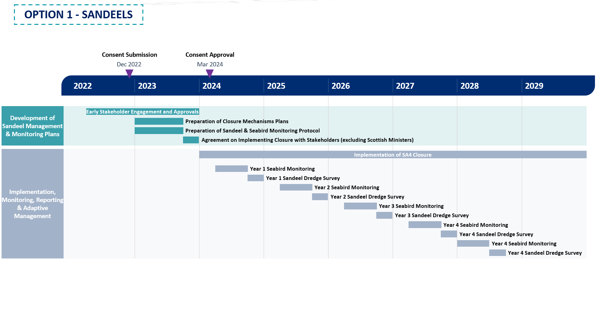
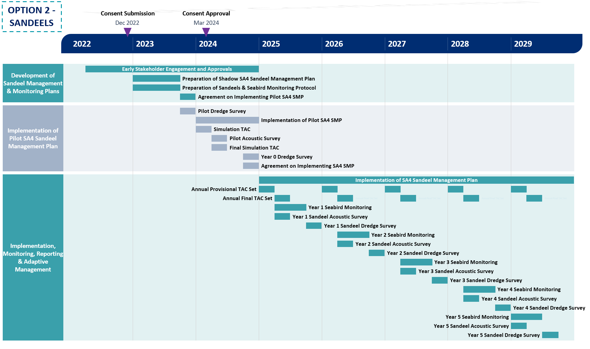
2.8. Programme for Implementation and Delivery
2.8. Programme for Implementation and Delivery
- Programmes 4 and 5 below present the indicative programmes for the implementation and delivery of Option 1 and Option 2 compensatory measures. These programmes provide a timetable for implementation and delivery of both options to deliver the compensatory measure, as well as a monitoring and reporting schedule. It should be noted that both options would continue throughout the operational lifetime of the Proposed Development however for the purposes of the programme only five years of monitoring and reporting are shown.
2.9. Adaptive Management
2.9. Adaptive Management
- It is recognised that the issues facing sandeel in SA4 and the seabirds which feed on them may change over the operational lifetime of the Proposed Development and the Applicant is committed to take appropriate action in the event that seabird monitoring shows the compensatory measure are is not offsetting the effects of the Proposed Development.
- The concept of adaptive management is central to the design and evolution of ecosystem-based fisheries management as the control measures are considered and re-assessed on an annual basis as a result of changes in the whole ecosystem which are known through an annual monitoring programme (as shown in Figure 2).
- The main drivers of adaptions within Option 2 are the outputs from the seabird and sandeel monitoring. The sandeel monitoring will enable TSB to be calculated on an annual basis and identify areas and sub-areas where stock may be increasing or decreasing. Management of these sub areas will take different approaches with various control measures implemented to ensure overall SA4 stock is recovering whilst allowing fisheries to open and be managed in a sustainable manner. The results of the seabird monitoring acting as an ecosystem trigger also adds another layer of adaption to the SA4 SMP ensuring overall coherence of the marine ecosystem.
- This ecosystem-based approach provides a unique opportunity for collaboration with other developments in the Forth and Tay region which could contribute to monitoring and sandeel management. This provides a potential route to facilitate compensation for other offshore wind farms (as set out in paragraph 45 above), if required. Increased sandeel monitoring at a finer scale will provide more data and contribute to the management of SA4 and setting of TAC to allow sustainable use of the fisheries. In addition, further contribution to, or involvement in, seabird monitoring can expand the programme providing more data and information on the effects of offshore wind farms on seabirds as well as effects of impacts on the sandeel population on seabirds.
- The overall adaptive approach to managing SA4 and the pressures it experiences will also mean that other external factors which may affect sandeel, such as climate change, or factors facing seabirds, such as avian flu, will be considered within this ecosystem approach. Given the uncertainty in the effects of climate change on plankton affecting sandeel, and hence seabird populations, the monitoring of sandeel stock in SA4, and the subsequent control measures which can be adapted and managed on an annual basis, will take account of potential changes in climate.
- Beyond option 1 and option 2, further adaptive management actions could be put in place to implement additional actions on scallop dredging or other fisheries (e.g. sprats) which seabirds feed on.
- There could be further opportunity to explore cessation/reduction in scallop dredging in the Firth of Forth Bank Marine Protected Area (MPA) and overlapping Outer Firth of Forth and St Andrews Bay Complex SPA to reduce harm to sandeel in their spawning zones. There is considerable uncertainty in the efficacy of restricting scallop dredging in order to benefit sandeel and it has not yet been possible to quantitatively predict the benefits of such a measure to the qualifying features of SPAs. However, this may be developed as part of the adaptive management plan, allowing gathering of the relevant information to predict the benefits to SPA seabirds should the proposed measures not be sufficient.
- In addition to this, the Applicant has also taken a tiered approach to adaptive management measures considering the package of compensatory measures proposed within this document. Consideration of tiered approach to adaptive management is presented in section 5.
3. Rat Eradication: Handa
3. Rat Eradication: Handa
3.1. Introduction
3.1. Introduction
- This compensatory measure proposes to eradicate the brown rat Rattus norvegicus from Handa, an island off the northwest coast of Scotland. Following eradication the Applicant will implement biosecurity measures, implement appropriate seabird habitat management, undertake monitoring and address any re-incursions.
- The objective of this measure is to increase black-legged kittiwake, common guillemot, Atlantic puffin, and razorbill populations on the island through the removal of predation pressure from brown rats.
- The Colony Compensatory Measures (CCM) Report submitted as part of the Derogation Case assesses the benefits expected from this measure and finds that island populations would increase following a successful eradication campaign based on analyses from raw colony count data has been obtained. Kittiwake, guillemot, puffin and razorbill are the key conservation targets of this measure, but several other species (non-target species) that currently breed on the island, or have done in the past, may also benefit. The conservation target of this compensatory measure is to increase kittiwake, guillemot, puffin, and razorbill populations on Handa to 11,838, 84,354, 1,784 and 10,647 adult birds respectively throughout the operational lifetime of the Proposed Development. The explanation and justification of these conservation targets are provided within the CCM Evidence Report.
- Further information regarding this compensatory measure is provided in section 2 of the Colony Compensatory Measures (CCM) Evidence Report
- This compensatory measure will follow on from a previous eradication attempt on Handa, as well as trials to assess the efficacy of self-re-setting traps (A24 traps) in a control context around seabird colonies (“the Handa Biosecurity for LIFE project”), which is due for completion in 2023.
3.2. Securing and Implementing the Compensatory Measure
3.2. Securing and Implementing the Compensatory Measure
- As part of the Section 36 consent for the Proposed Development, licences will be issued by Scottish Ministers which will detail conditions which the Applicant must adhere to, or discharge. It is anticipated that a condition will be included by the Scottish Ministers with regards to securing compensatory measures. A draft condition has been provided by the Applicant in section 6.5.
- This compensatory measure involves various stages comprising pre-eradication monitoring, eradication, implementing biosecurity, post-eradication monitoring (both in the immediate term and long term), seabird monitoring, seabird habitat management and implementing an incursion response plan in case of re-incursion. As such there are different approaches required to secure and implement the various stages. It should be noted that the Applicant will fund this compensatory measure, including continued management of biosecurity, and any eradication associated with re-incursion events during the operational lifetime of the Proposed Development.
- Handa Island is managed by Scottish Wildlife Trust (SWT) and is part of the Scourie Estate. It should be noted that Scourie Estate is supportive of the proposed compensatory measures and owns a large amount of the adjacent mainland that could be maintained as a rat free buffer. The Applicant is in the final stages of negotiating Heads of Terms with SWT and Scourie Estate to allow this measure to be implemented and monitored for the operational lifetime of the Proposed Development, as outlined above.
3.3. Implementation Mechanisms
3.3. Implementation Mechanisms
- Rat eradication at Handa will be implemented in four stages. Each stage is comprised of several sub-tasks, as outlined below. It should be noted that all stages will be designed to be compatible with the Biosecurity for LIFE guidance[2] and will build on the work undertaken as part of the Handa Biosecurity for LIFE project. The Applicant will develop, manage and implement each of these stages with input from specialist eradication experts and SWT as required.
- Pre-eradication
– Condensed Assessment and Feasibility Study
– Communications and Engagement Strategy
– Operational Plan
- Health and Safety Plan
- Non Target Species Management Plan
- Waste Management Procedures
– Pre-eradication Field Studies
- Eradication Preparation
- Seabird Census
- Vegetation Assessment
- Predation Monitoring
– Establish Biosecurity Plan
- Eradication and intensive monitoring
– Establishment of rodenticide grid
– Rodenticide baiting
- Improvements to seabird nesting habitat (where required)
- Monitoring, reporting and adaptive management
– Monitoring and Evaluation Plan
Pre-Eradication
Condensed Assessment and Feasibility Study
- The presence of brown rats on Handa is well evidenced, most recently through the Handa Biosecurity for LIFE trail, as discussed in the CCM Evidence Report. Using information from this trial a Condensed Assessment and Feasibility Study will be undertaken considering UK Rodent Eradication Best Practice Toolkit (Thomas, Varnham, and Havery, 2017). This study will assess the abundance and distribution of rats on the island, its islets and the mainland foreshore. This study will also include collation and assessment of seabird census data to report on the trends in the numbers of the target seabirds. An assessment of nesting habitat available to key species, supported by information from seabird colony assessments, will also be undertaken. Observations on the availability of unoccupied habitat that could support an increased number of target seabirds will also be included. A key part of this Condensed Assessment and Feasibility Study will also be to will also be to assess and extract relevant learning from the previous eradication measures on Handa that led to the incursion.
- The available information from previous studies confirms that eradication of brown rats is a feasible option to increase seabird numbers on Handa and therefore this Condensed Assessment and Feasibility Study will inform the preparation of an Operational Plan to deliver and implement the eradication programme, and the associated monitoring, reporting and adaptive management required both for the eradication programme and seabird habitat enhancement.
Communication and Engagement Strategy
- Once plans and further studies are undertaken, as described below, key stakeholders will have the opportunity to comment on the planning and requirements of the eradication and ongoing biosecurity and be engaged throughout the operation of the compensatory measure.
- Stakeholders will be informed about all aspects and stages of the compensatory measure and engaged throughout the implementation, and monitoring stages of the project. To facilitate this a Communication and Engagement Strategy will be prepared to ensure stakeholders are kept engaged and informed.
- This strategy will outline the approach to communicating and engaging with stakeholders, members of the public and the media. Some examples of information that this may include are:
- Using key applicable information from the Campaign for Responsible Rodenticide Use (CRRU). CRRU has developed a good practice leaflet on the use of rat poison and the threats to wildlife (CRRU 2021). This leaflet outlines methods to prevent rodent infestations, methods to control rats, information on trapping, rodenticides and resistance and the dangers to wildlife (particularly raptors and other birds of prey) for the general public.
- Strategy to engage with visitor boat operators regarding the purpose of eradication and the implementation of biosecurity measures
- The erection of information boards and notices on Handa to notify people of the programme and provide warnings and risk information regarding the bait stations and the presence of rodenticides.
- Clear warning signs (detailing the eradication, bait station design and danger from bait) would be placed on Handa at all suitable landing beaches. Warning labels will be placed on all bait stations advising visitors not to touch the stations or bait.
- Whilst the Communication and Engagement Strategy will be developed at the outset of the project, it will be updated and adapted during the lifetime of the measure, depending on outcomes of the eradication programme and the implementation of biosecurity measures.
Operational Plan
- In advance of commencing an eradication programme an Operational Plan will be developed. The Operational Plan will be informed by all other eradication campaigns previously undertaken on Handa. This will include a full review of the planning documents from the Handa Biosecurity for LIFE Project. The Operational Plan will define the following:
- Scope and method statements
- Approach to permitting
- Organisational arrangements
- Health and Safety Plan
– A detailed information sheet outlining the hazards associated with the proposed rodenticide will be prepared for the eradication team as part of the Health and Safety plan prior to operation. This will include:
- Requirements of Control of Pesticides Regulations 1986
- Safe working procedures
- Emergency preparedness
- Waste management (It is important that alternative food is not available to rats on Handa during the eradication. Waste will be collected by the team and transported back to the mainland for disposal. Waste bait, rat carcasses and used monitoring tools will be disposed of at a registered landfill or incineration facility)
- Specialist subcontractor engagement (rope access and horticultural services),
- Mitigation planning
- Non-target species management plan
- Approach to adhering to Communication and Engagement Strategy
- Long term monitoring and biosecurity planning.
- A number of Health, Safety and Environmental requirements will need to be met prior to the operational phase of the proposed eradication. These include, but are not limited to, Animal Ethics approval to undertake key species research and monitoring and training of operational staff in rodent control (as required).. The Applicant will ensure these requirements are adhered to in advance of commencing eradication and does not consider there would be any impediment to obtaining these approvals due to the following a similar approach to other eradication campaigns previously undertaken on Hanna.
- The proposed rat eradication operation on Handa will be assessed using the internationally recognised ethical principles of Humane Vertebrate Pest Control developed by RSPCA Australia (Humane Vertebrate Pest Control Working Group, 2004). The proposed eradication operation satisfies all the criteria of the Humane Vertebrate Pest Control principles.
- The subsections below provide more detailed information on some of the above aspects which are likely to be included within the Operational Plan.
Pre-eradication Field Studies
- Key species monitoring and field studies will be undertaken prior to, during and after the proposed eradication.
- Monitoring projects on Handa will be established as part of the proposed eradication project. Monitoring will commence in the spring and summer ahead of a winter eradication to enable baseline information to be collected, this is outlined in section 3.5. This monitoring will continue for two years after the eradication phase. A detailed Evaluation and Monitoring Plan will be prepared to ensure relevant, robust, and accurate data collection procedures, data storage and analysis. Further information on the approach to monitoring and reporting is discussed in section 3.4.
- Seabird habitat field measurements (ledge dimensions, soils structures etc), testing for positioning of anchor stations for any rope access, and a seabird census will be undertaken with a full colony baseline count using recognised methods as detailed in Walsh et al 1995, including photographic records and digital mapping.
- It is also important to assess the level of native predators (i.e. raptors and gulls) on Handa to determine what effect these species may have on the recovery and spread of seabirds on the island.
Biosecurity Plan
- Once rats have been successfully eradicated from Handa, the priority is to ensure that they do not become re-established on the island. As such, an effective Biosecurity Plan will be developed and fully implemented prior to the eradication phase of the programme.
- Biosecurity measures need to be put in place to ensure the rat-free status is maintained. Biosecurity planning involves the identification of risk species and potential ‘pathways’, such as boats, helicopters, visitors, lighthouse boards and construction work. Prevention measures are required to ensure that invasive species are not transported via these potential pathways. The Biosecurity Plan will be developed together with input from SWT who manage Handa as well as vessel operators.
- The Biosecurity Plan will be based on approach and measures set out by Biodiversity for LIFE and will provide details to minimise the risk of accidental liberation of rats, and what measures should be taken if a rodent is sighted on the island. If rats are detected on Handa within two years, it is important to be able to distinguish between the failure of the eradication and a biosecurity failure. DNA samples of brown rats from Handa and other locations across the UK, and brown rats from nearby islands and the mainland will be collected and stored in advance of eradication. Trapping of rats and the use of trail cameras will be important to determine species to confirm eradication failure or incursion.
- The greatest risk of reinvasion is from the mainland. Rodents can be accidentally transported by a number of means, such as local charter boat movements, visiting tourists, visiting researchers and private yachts visiting Handa. The Biosecurity Plan will ensure these visiting vessels will be advised of the rat-free status of Handa, through the Communication and Engagement Strategy, and asked to maintain vigilance. Quarantine practices from other islands (such as St Kilda, Lundy Island, Isle of Canna, St Agnes and Gugh, Shiants), for example may be able to be adapted for use on Handa.
- As Handa is within swimming range of brown rats, biosecurity needs to be maintained for the operational lifetime of the Proposed Development. It will be important to educate local SWT staff or any other relevant agencies and stakeholders as well as the landowner to ensure that the biosecurity can continue to be implemented by these groups in the long-term. Data collection and management is important (particularly if incursions are detected and subsequently eradicated); all sightings and other rodent-related observations should be recorded and investigated.
- As part of the Biosecurity Plan an Incursion Response Plan will be prepared which comes into force should the reoccurrence of rats be detected. The quicker the response, the easier it is likely to be to initiate further removal and for this to be successful as only a few animals may be involved (Thomas & Varnham 2016).
- It should be noted the Applicant will fund the preparation of the biosecurity plan and incursion response plan, as well as the continued implementation of associated biosecurity and incursion response measures.
Eradication and Intensive Monitoring
- The proposals within this section provide an outline of the currently proposed approaches to eradication and monitoring. These approaches will be confirmed and agreed with stakeholders when preparing the operational plan.
- The eradication programme on Handa will be a ground-based operation using bait stations. The use of anticoagulant rodenticides is currently the most widely recognised effective method of eradicating rodents from islands (DIISE, 2018), therefore anticoagulant rodenticide (or an alternative) will be positioned in a bait station spread in a 25 metre x 25 metre grid across the island (approximately 1300 bait stations).
- Each bait station will have an individual number, plotted using GPS and all data put into a GIS-linked database. Once all the bait stations are in position on Handa, they will be left for one week or more (without toxin in them) so the rats become accustomed to them and accept them as part of the terrain. Following this the rodenticide will be added to the bait stations.
- Bait stations will be checked a minimum of every two days, replacing bait as rats consume it. Partially eaten bait will be replaced with a new block. Old or partially eaten bait will be disposed of at a registered landfill or incineration facility as recommended by the safety data sheets. Checking bait stations enables constant monitoring of bait take and the resulting die-off of rats. The success of the eradication and any problems, which need to be overcome during the programme, require the detail of accurate recording.
- Bait take will be recorded into GIS-linked database apps in the field for ongoing analysis. Refinements to the eradication phase can be made from this real time data. Hot spots can be identified quickly and targeted throughout the programme allowing for real time adaptive management.
- The eradication phase will be carried out in the winter when rodent numbers are naturally at their lowest, and when natural food supplies are low. This means that there are fewer rodents to catch, and those that do remain are more likely to take the bait in the absence of other food sources.
- Baiting will begin in November and continue through to March (overlapping with the early intensive monitoring phase of the programme, as outlined in section 3.5). Any surviving rats or problem areas would be apparent by the end of December and could be treated with an alternative poison or techniques.
Improvements to Seabird Nesting Habitat
- In addition to eradication, adaptions, improvements, or enhancements to nesting habitat for target seabird species will be implemented. This will be outlined in the Monitoring and Evaluation Plan produced as a result of the pre-eradication field studies. This will include options to accelerate occupancy of habitat by target seabird species.
Monitoring, Reporting and Adaptive Management
- A Monitoring and Evaluation Plan will be developed by the Applicant in consultation with NatureScot, SWT and RSPB. Not only will this include details to monitor the success of the eradication programme but also will include seabird monitoring which will be required to establish whether the conservation targets are achieved. Further information on this is detailed in section 3.4 and considerations of adaptive management approaches are discussed in section 3.6.
3.4. Monitoring and Reporting
3.4. Monitoring and Reporting
Approach to Monitoring
- Successful implementation of the eradication will contribute to improving both the number of seabirds nesting on Handa and their breeding success.
- As stated above, a Monitoring and Evaluation Plan will be developed, pre-eradication, which will outline the various stages of monitoring as well as including progress indicators to allow the Applicant to determine the success of the compensatory measure. The monitoring will be reported against the progress towards the conservation targets for each species throughout the operational lifetime of the Proposed Development. The stages of monitoring will include immediate monitoring, long term monitoring and seabird monitoring. These are outlined in turn below.
Immediate Monitoring
- Once the baits have been set, early monitoring and surveillance is required to assess the success of the baits. This will involve maintaining bait stations, searching, recovering and disposing of rat carcasses, installing and maintaining a monitoring network and implementing local biosecurity measures (as discussed above). The Applicant will ensure there is sufficient resource and funding to identify any incursion and seek to intercept any rat before it can breed and re-establish a population, for example a biosecurity warden to lead on this with support from SWT staff as appropriate.
- The coverage of the monitoring grid will extend beyond that of the bait stations; one monitoring point at the station and one in-between two stations. Each monitoring site will be checked every two days to detect rat sign (for example teeth marks or footprints or footage on camera). If any rat sign is detected, an intensive targeting programme would be started until rat sign in the area ceases.
- All intensive monitoring points will be recorded on GPS, entered into the GIS-linked database, and mapped to ensure coverage of the island.
- After about six weeks, bait take should be reduced to nil, with all the rats on Handa having been eradicated. During the following three months it is vital to establish an intensive monitoring programme to detect any rats which may have escaped eradication. A grid of rat-attractive food items as well as chew cards would be pegged out as monitoring tools. Tracking tunnels and trail cameras would also be used. Beach surveys for footprints in the sand would also occur.
- It is expected that the monitoring phase of the programme would begin from mid-December following the eradication campaign. The bait station grid can be removed once the intensive monitoring phase has been completed and rat sign is absent. If rats are detected at the end of winter (i.e., February and/or March) a second baiting (i.e. during the following winter) and continued monitoring operation would be completed to finish the eradication.
Long-Term Monitoring
- Following international best practice, long-term monitoring for surviving (or reinvading) rats will continue for two years between the end of the eradication phase before declaring the island rat-free. This is based on the average life expectancy of a wild adult rat (which is approximately 18 months).
- The two-year long-term monitoring programme should be continued for at least every four weeks throughout the year to confirm the success of the eradication phase (i.e., to detect any surviving (or possible invasion) of rats). Permanent monitoring stations will be placed around the island (i.e., within known seabird areas, optimum rat habitat and in high-risk areas) to aid with detecting any surviving rats or intercepting invading rats.
- Once the two-year monitoring phase has been completed and no rats have been detected, one further intensive island-wide monitoring check is completed. This involves putting a range of monitoring devices over the entire island and checking every two days for six weeks. Once this check is completed and no rats have been detected the island can be declared rat-free.
- All long-term monitoring points should be recorded on GPS, entered into the GIS-linked database, and mapped to ensure coverage of the islands. Any sign or indication of rodents should be photographed and if possible, collected or sampled for expert opinions on identification.
- This long-term monitoring for the presence of rodents after an eradication operation is done as part of the biosecurity programme and will be undertaken by qualified eradication specialists with support from SWT staff on the island. It is important to monitor using a range of detection devices (such as flavoured and plain wax, chew cards, traps, rodent motels, trail cameras and indicator dogs) and have a regular search effort. Low numbers of rats may take longer to detect than realised. It may also be possible to use the recovery of vulnerable species (such as puffin) or establishment of prospecting species (e.g. Arctic tern) to indicate that rats have been successfully eradicated.
- It is important to use a variety of lures and monitoring techniques regularly throughout the biosecurity and long-term monitoring for rodent incursions. Periodic audits and on-going monitoring of these biosecurity measures will be completed to ensure compliance and support. It is important that all involved realise that biosecurity is a long-term ongoing commitment.
- Protocols will be established, and outlined with the Communication and Engagement Strategy, during the eradication and training given to local SWT staff and the landowner to ensure that biosecurity measures are implemented alongside the long term monitoring, as funded by the Applicant.
Seabird Monitoring
- Once the island is declared rat free, seabird monitoring would be undertaken. This will complement the existing monitoring currently undertaken as well as the monitoring undertaken by the SWT ranger and volunteer team (bird counts and productivity monitoring). the Monitoring Plan will be developed and agreed in consultation with SWT.
- Monitoring may involve taking colony counts and recording data on productivity (i.e. number of chicks fledged per breeding pair). Colony counts would need to be undertaken using the published methodologies, which differ for each of the target species. To effectively monitor productivity, two to five visits may be required for Kittiwake, two to six visits for Razorbill, and two to four visits for Puffin. Monitoring Guillemot productivity is extremely difficult and would require three visits during late incubation/early hatching and visits every one to two days once most chicks are hatched (Gilbert et al. 1999).
Approach to Reporting
- The monitoring outlined above should be considered as progress indictors to be used to measure the success of eradication (i.e. the island being declared rat free against the outcomes of seabird monitoring and the progress towards the conservation targets for each species throughout the operational lifetime of the Proposed Development. This will be detailed in annual monitoring reports. Although recovery is unlikely to occur in a linear fashion, as seabird counts always fluctuate, the conservation benefit (as outlined in section 3.1) is framed in annual terms to allow comparison with potential mortality estimates for the Proposed Development.
- At the end of each year once the eradication programme has commenced an annual report will be produced. The annual monitoring report is likely to follow this structure:
- Overview of evidence of rat re-incursion (if any)
- Overview of implementation of biosecurity measures
- Overview of the results from seabird monitoring (section only included once island is declared rat free)
– Colony counts
– Mapping nest locations
– Productivity monitoring
- Actions delivered
– Actions to manage biosecurity
– Actions to improve seabird habitat
- Identification of emerging issues
- Approach to biosecurity measures for the following year
- Approach to monitoring for the following year
- The annual monitoring reports and data collected would be shared with key stakeholders including SWT, NatureScot and RSPB and all data collected made publicly available where appropriate. The results of the monitoring report would be used to update the Biosecurity Plan and subsequent implementation of measures to improve seabird habitat.
- If any re-incursions did occur and the Incursion Response Plan was implemented a report summarising the likely cause of the incursion, the approach taken for further eradication and adaptive management measures to be implemented would be prepared.
3.5. Programme for Implementation and Delivery
3.5. Programme for Implementation and Delivery
- Programme 2 below presents the indicative programme for the implementation and delivery of this measure on Handa. This programme provides a timetable for implementation and delivery of the compensatory measures, as well as a monitoring and reporting schedule. I
- The objective of this measure is to increase kittiwake, guillemot, Atlantic puffin and razorbill populations on the Handa through the eradication of rats. The Applicant is committed to keeping Handa rat free for the operational lifetime of the Proposed Development, however, the programme below only provides an outline of the monitoring and reporting schedule for five years post declaration of a rat free island, for illustrative purposes. Nonetheless, the Applicant will be undertaking annual monitoring and reporting for the duration of the operational lifespan of the Proposed Development and implementing incursion responses plans if re-incursion of rats ever were to occur.
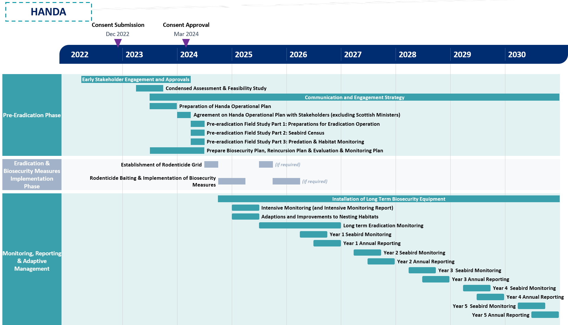
3.6. Adaptive Management
3.6. Adaptive Management
- The approach to adaptive management for this compensatory measure is considered in two parts. Firstly, adaption in response to re-incursion or biosecurity failure, and secondly, adaption in the form of habitat management.
- As outlined in section 3.1, maintaining the island rat free is key to achieving the objectives of the compensatory measures at Handa. Should the reoccurrence of rodents be detected the Incursion Response Plan will be implemented and followed. If re-incursion is a result of a failure of eradication, adaptive solutions may include different locations of bait stations, different bait, alternative rodenticide to be used or trapping for example. If re-incursion was a result of a failure in biosecurity measures the Applicant would seek to work with SWT, the qualified contractor, vessel operators and other visitors/users of the islands to understand why the biosecurity measure failed and implement alternative measures to ensure biosecurity was maintained. The Communication and Engagement Strategy would also be re-visited and adapted as appropriate.
- It is recognised that the issues facing seabirds on Handa may change over the operational lifetime of the Proposed Development and the Applicant is committed to take appropriate action should measures fail to work as expected. In the event that monitoring shows that the compensatory measures are not progressing towards their conservation targets (as defined in section 3.1), new measures would be developed or adaptions made to managing seabird habitat. Key to the success of this approach is for the annual monitoring reports to identify emerging issues, and where necessary gather data and develop adaptive management solutions and corrective measures. These adaptive management measures could include:
- Artificial ground cover could be considered as an adaptive measure following rat eradication, to further increase breeding performance at potential cliff-top breeding sites as well as artificial nesting boxes.
- Social attraction methods, such as playbacks and decoys, could be used to increase the likelihood of recruitment.
- Vegetation management, comprising reduction in height and density of grasses and shrubs and loosening of soils on tops of steep slopes may be adopted prior to the start of the nesting season to optimise conditions and create space and access for target seabird species, notably burrow nesting puffin.
- White paint could be used to simulate guano at potential breeding sites This could be used for the auks, potentially alongside the use of vegetation management, decoys and playbacks, with the aim of increasing colonisation rates following rat eradication.
- This iterative and adaptive approach to implementation and monitoring is key to achieving the objectives of the compensatory measures at Handa.
In addition to adaptive management measures which are specific to rat eradication and seabird habitat management at Handa, the Applicant has also taken a tiered approach to adaptive management measures considering the package of compensatory measures proposed within this document. Consideration of tiered approach to adaptive management is presented in section 5.
4. Dunbar Castle Wardening Role
4. Dunbar Castle Wardening Role
4.1. Introduction
4.1. Introduction
- The third compensatory measure to be implemented by The Applicant is wardening of kittiwake colonies on the mainland site of Dunbar Castle. The wardening position is provided as an umbrella role to implement a series of sub-measures to reduce human disturbance and improve nesting habitat for Kittiwakes in Dunbar Castle.
- The objectives of the wardening role are to identify limiting factors to the colony and implement solutions to improve both the number of birds nesting at Dunbar and their breeding success. These objectives will be measured through a conservation target of approximately 400 pairs (800 birds) to bring the colony back to numbers observed in 2020 (this was before the avian influenza outbreak experienced in 2022) with the aim of this compensatory measure to put the colony on a trajectory towards recovery to 2020 levels. The explanation and justification of this conservation target is provided within the CCM Evidence Report.
- The warden will also be employed to investigate a range of colony-based issues that may be contributing to the decline of this locally significant Kittiwake colony. The results of these studies will inform the design of each sub-measure on an iterative basis.
- Further information regarding this compensatory measure is provided in Section 4 of the CCM Evidence report submitted as part of the Derogation Case.
4.2. Securing and Implementing the Compensatory Measure
4.2. Securing and Implementing the Compensatory Measure
- As part of the Section 36 consent for the Proposed Development, licences will be issued by Scottish Ministers which will detail conditions which the Applicant must adhere to, or discharge. It is anticipated that a condition will be included by the Scottish Ministers with regards to securing compensatory measures. A draft condition has been provided by the Applicant in section 6.5.
- The proposal is for the warden to be employed by East Lothian Council (ELC) and this position would be fully funded by the Applicant. Agreement in principle on this approach has been reached with ELC that the Applicant will provide appropriate funding to pay for the employment of the warden and the associated implementation of the various compensatory measures for a period of at least five years. Heads of Terms regarding this have been agreed and signed between the Applicant and ELC.
- Dunbar Castle was formerly owned by ELC, and ownership was transferred in 2004 to the Dunbar Harbour Trust (DHT), a charity set up by a number of harbour users with the aim of improving the harbour facilities for the professional and leisure users. The Board’s mission statement is to ‘run a safe, efficient and welcoming harbour that caters for the needs of all the harbour users, visitors and the local community as well as the environment’. One of the strategic objectives identified by the Board is improvement of the environment within the harbour.
- Access requirements and landowner agreement, to allow the warden to undertake monitoring and implement the compensatory measures, will be secured through Heads of Terms between the Applicant and DHT. As ELC already have an agreement with DHT to carry out works, as they carry some of this work already, the warden would work under this agreement. DHT has also offered the warden the use of a room within the Harbour Office.
- Dunbar Castle is a Scheduled Monument, and Dunbar Harbour is a historic conservation area. However, with careful design and the use of non-invasive installation techniques, the Applicant does not anticipate a requirement for consent under s. 2 Ancient Monuments and Archaeological Areas Act 1979. If consent is required, an application would be made to Historic Environment Scotland (HES). As non-invasive installation techniques would be used to avoid any structural change to the scheduled monument, the Applicant does not foresee any impediments to gaining such permission.
- The above information provides evidence that The Applicant is committed to and has made substantial progress towards delivering the compensatory measure.
4.3. Implementation Mechanisms
4.3. Implementation Mechanisms
Baseline Data Collection
- Although there is good information available about the Kittiwake colony at Dunbar Castle, further studies are planned in advance of implementation to either identify or confirm the actions required in order to achieve the objectives of the compensatory measures
- As such, the collection of baseline data from one breeding season (in advance of implementing any compensatory measures) is required to enable the most appropriate measures to be implemented and to gather baseline data on the colony as it stands, so that this can be compared with data gathered in the post-implementation period. This allows the warden the opportunity to gather a season’s data which would then be used to develop an Operational Kittiwake Management Plan.
- The baseline data collection is likely to focus on understanding three main objectives as outlined below.
- Kittiwake Colony
– Baseline data on the extent and productivity of the current kittiwake colony is required to inform the development of an Operational Kittiwake Management Plan. The approach to collecting the data may involve collecting information on the number of nests, location of nests, attendance rates, check feeds and productivity in different nesting areas. This data collection would be undertaken by the warden.
- Sources of disturbance
– Community engagement will be central to the success of these compensatory measures, and an approach which seeks to understand why people are visiting Dunbar Harbour and that takes their needs into account (alongside those of the Kittiwakes) is considered more likely to result in long-term success. This approach would also accommodate the goals of DHT (as discussed in section 4.2), who are an engaged stakeholder in this work.
– The warden will engage with both fishermen and other users of the harbour as well as the general public to identify sources of human disturbance noting publicly accessible areas and proximity to nests, offshore recreational use of the harbour and surrounding waters, vessel movements in harbour as well as identifying sources of litter in both castle area and within the harbour. This information will be needed to determine how various types of disturbance may be impacting birds, and to establish how these may be tackled.
- Constraints to kittiwake habitat
– A better understanding of productivity across the different sub-colonies in Dunbar Castle will be needed to understand how successful each of the sub-sites are before habitat enhancement could be considered. Productivity data from other locations such as the rocky outcrops, the magazine and the cliffs are needed to assess whether similar problems occur and whether habitat enhancement in the form of more ledges higher up would be of benefit in these specific areas.
– Collecting information under the above two workstreams will help to identify constraints to kittiwake habitat (be it through proximity to sources of disturbance or use of litter within nests for example), potential habitat areas which could be enhanced and potential further nesting spaces.
– The warden will identify currently used nesting areas as well and potential nesting areas and the suitability of these for enhancement.
Kittiwake Management Plan
- In advance of baseline data collection, a Kittiwake Management Plan will be prepared. This will outline the measures to be implemented, the actions to manage human disturbance, the actions to enhance habitats and the protocols to follow to monitor the kittiwake colony. The Kittiwake Management Plan will set out how the success of each element will be monitored and measured themselves so that the benefits of the compensation can be quantified. This Kittiwake Management Plan will be consulted on with NatureScot, RSPB, ELC, HES and DHT to ensure all proposed management measures can be feasibly implemented and monitored.
- Once the warden has undertaken baseline data collection they will prepare an Operational Kittiwake Management Plan, based on the approved Kittiwake Management Plan. As shown in Figure 3 Open ▸ , the Operational Kittiwake Management Plan will be updated during the operation phase of the Proposed Development (currently expected to be annually, based on the outcomes of monitoring (as discussed in section 4.4) and produced following analysis of baseline data so that effort can be targeted strategically. This process helps ensure that the concept of adaptive management is central to the design and evolution of the project. Any actions taken would be transparent and made available to other Harbour users. Further details on the approach to monitoring and reporting is provided in section 4.4.
Figure 3 Adaptive Approach to Implementing Compensatory Measures at Dunbar Castle
- Subject to the collection of baseline data, the Operational Kittiwake Management Plan may include the following measures to manage human disturbance as well as actions to enhance kittiwake habitat:
- Actions to manage disturbance
– The warden will engage with both the harbour users (including fishermen and recreational users) as well as the general public. One of the umbrella roles of the warden will be providing education to the general public and liaison with fishermen. This will be carried out to address both human disturbance and marine litter, with an aim to engender a sense of connection to and ownership / conservation of the Kittiwake colony. Education/liaison may include:
- Visits to local schools;
- Provision of tours to the colony;
- Information provision to tourists;
- Improving public awareness of the colony through social media (led by ELC with input from the warden);
- Warden to be on site at the Castle Battery in the tourist season at specific times with a telescope to provide opportunities for both visitors and members of the local community to see the birds and learn more about them;
- Liaison with fishermen and a representative of the fishing community to be kept aware of what is happening within the harbour, have a clearer understanding of what the issues are, and also what will be expected from them and why; and
- Codes of conduct could be developed with local groups if required.
– The warden will reduce human disturbance at Dunbar castle through the following mechanisms:
- Restricting access to the front face and entrance stepway on the south side of the harbour;
- Fencing off the green in front of the steps to add a buffer between the kittiwakes and the public;
- Keeping watch and stopping children throwing stones at the kittiwakes nesting;
- Education and liaison (as above).
- Actions to manage kittiwake habitat
– The warden will reduce fishing litter / debris from nests at Dunbar castle through the following mechanisms:
- Removal of plastic from nest sites over the winter (i.e. outside the breeding season), clipping any trailing net or rope and removal of small pieces of plastic (complete removal is not possible as the nests are used annually) – this would include liaising with ELC and the Conservation Officer to handle the building’s historic status, and support from a climber for hard to access areas (if required).
– Kittiwake habitat enhancement will be undertaken using the following mechanisms
- This measure may include adding artificial ledges and overhangs in certain areas (in winter), ensuring these are the correct size to prevent access from herring gulls; and carried out through liaison with stakeholders. After the Castle and Inner Castle, the Magazine is considered the next best nesting area. It should be noted that any habitat enhancement will be undertaken outside of the breeding season to avoid further disturbance.
- In view of the historic value of the site, further liaison would be required involving the local Conservation Officer to agree an acceptable plan for the work. These areas are also challenging to access, so skilled contractors would be required. These details will be discussed with the relevant stakeholders post-consent to inform the detailed plan.
4.4. Monitoring and Reporting
4.4. Monitoring and Reporting
Approach to Monitoring
- Successful implementation of the compensatory measures will contribute to improving both the number of birds nesting at Dunbar and their breeding success. Monitoring of the colony will be undertaken to show whether the various compensatory measures outlined in section 4.3 have been successfully implemented and progress is being made towards reaching the conservation target (as outlined in section 4.1).
- Alongside the production of the Kittiwake Management Plan a Monitoring Plan will be developed. This will outline how the warden will monitor both the kittiwakes and their nests, as well as activities causing pressure to the birds. Progress indicators will be included in the Monitoring Plan to allow the warden to determine the success of each compensatory measure.
- The list below details the type of approach that could be undertaken as part of the Monitoring Plan to assess and quantify the benefits of both the proposed compensatory measures. This list provides some detail on the monitoring principles and approach that could be adopted and tailored as the project progresses. Examples include:
- Monitoring kittiwake colony (these align with the disturbance monitoring proposed below)
– Annual colony counts
– Mapping of nest locations
- Mapping exercise to look at the spatial distribution of different types of disturbance around the harbour in relation to nesting areas
- Identify overlap areas and investigate potential solutions e.g. relocation of activities if possible
– Productivity monitoring
– Chick provisioning, this could be monitored effectively using cameras (see below), which could be positioned to cover several nests
– Monitor presence of litter within kittiwake nests
- Monitoring disturbance
– Monitor activities and their frequency of occurrence
- Look for whether there are more nests and/or more successful nests in less disturbed areas. Look at whether specific activities elicit responses from the birds.
– Monitor number of disturbance events with and without warden present (model experiment design on Liley and Panter 2017)
- Assess and quantify the extent to which warden presence is effective in reducing disturbance. (If warden presence is not effective, then the reasons for this need to be evaluated as a part of the adaptive management procedures, as discussed in section 4.6).
– Monitor response of birds to different activities
- Test whether specific activities are more disturbing and then investigate why (e.g. is it because they are loud, or because they are conducted close the colony?
– Monitor number of nests and nest productivity in disturbed and less disturbed areas
- Test whether there are more nests in less disturbed areas.
- Test whether productivity is higher in less disturbed areas.
– Monitor effectiveness of fencing/restricting access to problem footpaths in reducing disturbance
- Restrict access to one of the key footpaths and monitor number of nests and productivity
- Test whether productivity improves using existing data as a baseline.
- Look at whether the number of nests increase in areas where access has been restricted.
– Monitor number of disturbance events from local children
– Test whether disturbance events from local children reduce as the project progresses
- Arrange school visits and continue to monitor during the project lifetime
– Count visitor numbers at public engagement initiatives
- Test whether visitor numbers at engagement events increase
– Undertake social media campaign and surveys of visitors ask them to score their interest in the Kittiwake colony (along with other potential reasons for visit).
- Look at the level of interest people express in the Kittiwakes during surveys and test whether this increases as the project develops over time.
- The Applicant is committed to digital transformation and where appropriate applying innovative approaches to implement and monitor compensatory measures. One such opportunity for digital innovation for the measure proposed to be implemented at Dunbar Castle is with regards to monitoring the kittiwake colony. The Applicant has held discussions with the Scottish Seabird Centre, East Lothian Council, Dunbar Harbour Trust and FSG about installation of monitoring equipment at key nesting locations within Dunbar Castle and providing a live feed to within the Seabird Centre. The cameras would record footage throughout the day, and use a new technique to count birds using artificial intelligence (AI) and image-recognition technology. This would help minimise disruption to birds’ breeding and feeding habits as this is less invasive than traditional monitoring approaches and is more efficient and accurate, saving the warden many hours physically watching nests.
- The data would collect information on nest residency time and how often there is disturbance for example. It should be noted that camera installation would be undertaken in the winter period following best practice guidance. This builds upon a successful trial of this technology between SSE Renewables, Microsoft, Avanade and NatureScot whereby the AI was used to count puffins in the Isle of May. The Applicant will continue discussions with their partners and other stakeholders in 2023 and implement a trial of the technology in advance of baseline data collection to ensure the technology is in place and running in time for undertaking the first year of monitoring, as outlined in section 4.5.
Approach to Reporting
- The monitoring outlined above should be considered as progress indicators to be used to measure the implementation of measures against the outcomes of monitoring and this will be detailed in annual monitoring reports.
- It is inevitable that the list of compensatory measures required will vary somewhat between years: for example, removal of plastic from nests may not always be required annually, and therefore could be carried out less frequently. Therefore, at the end of each year an annual report will be produced. The annual monitoring report is likely to follow this structure:
- Overview of the results from monitoring each compensatory measure
– Colony counts
– Mapping nest locations
– Productivity monitoring
– Chick provisioning
- Actions delivered
– Actions to manage human disturbance
– Actions to manage kittiwake habitat
- Identification of emerging issues
- Approach to implementation for the following year
- Approach to monitoring for the following year
- The annual monitoring reports and data collected will be shared with key stakeholders including ELC, DHT, NatureScot, RSPB, Scottish Seabird centre and FSG and all data collected made publicly available where appropriate. The results of the monitoring report will be used to update the Operational Kittiwake Management Plan and subsequent implementation of measures on an annual basis as shown in Figure 3 Open ▸ .
4.5. Programme for Implementation and Delivery
4.5. Programme for Implementation and Delivery
- Programme 3 below presents the indicative programme for the implementation and delivery of the Dunbar Castle wardening role compensatory measure. This programme provides a timetable for implementation and delivery of the compensatory measures, as well as a monitoring and reporting schedule.
- The objective of the compensatory measures is to put the colony on a trajectory towards recovery to 2020 levels. The success of this measure will be reviewed on an ongoing basis and will be continued if it is demonstrated to be effective. Should monitoring show the measures do not deliver as expected then various adaptive management approaches (as outlined in section 5) will be considered.
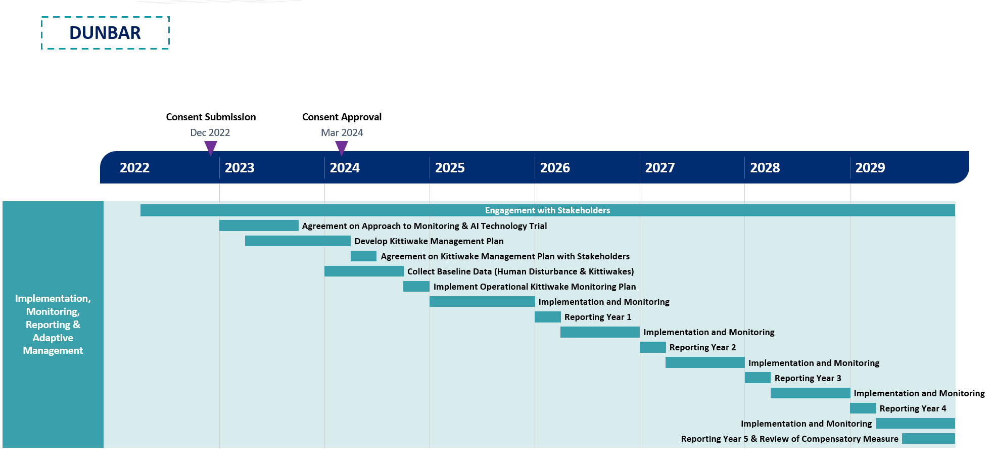
4.6. Adaptive Management
4.6. Adaptive Management
- It is recognised that the issues facing kittiwakes at Dunbar Castle may change over the lifetime of the project and the Applicant is committed to take appropriate action should measures fail to work as expected.
- In the event that monitoring shows that the compensatory measures have not reached their objectives new measures would be developed or adaptions made to each proposed measure. Key to the success of this approach is for the warden to identify emerging issues, and where necessary gather data and develop adaptive management solutions and corrective measures. These corrective measures would be developed as a result of monitoring (as outlined within each annual Monitoring Report), included within the annual update of the Operational Kittiwake Management Plan, and subsequently be implemented and then monitored. This approach is shown graphically in Figure 3 Open ▸ . These corrective measures could include increasing intensity of visitor/public engagement, changing warden watch hours to stop significant disturbance events at different times of day, provision of additional nesting habitat in more favourable locations than currently used by kittiwake, closure or diversion of different footpaths / accessible areas in proximity of nesting areas or additional signage to inform visitors, for example.
- This iterative and adaptive approach to implementation and monitoring is key to achieving the objectives of the compensatory measures at Dunbar Castle.
- In addition to adaptive management measures which are specific to kittiwake management in Dunbar Castle, the Applicant has also taken a tiered approach to adaptive management measures considering the package of compensatory measures proposed within this document. Consideration of tiered approach to adaptive management is presented in section 5.
5. Adaptive Management
5. Adaptive Management
- Whilst the Applicant is confident all compensatory measures can be successfully implemented, and achieve their conservation targets to increase seabird populations (for which significant evidence has been collated to support this (CCM FCM Evidence Reports)), three approaches to adaptive management have been developed by the Applicant so appropriate action can be taken in the event that monitoring shows the compensatory measures are not progressing towards their conservation targets. These three approaches are:
- Built in adaptive management;
- Secondary compensatory measures; and
- Strategic adaptive management.
Built-in Adaptive Management
- The Applicant has outlined adaptive management measures through this document (which are specific to each compensatory measure) to be implemented if monitoring demonstrates that the proposed measures have not delivered the required amount of compensation. The approaches to this form of adaptive management are built into each compensatory measure.
Secondary Compensatory Measures
- A list of secondary measures proposed as adaptive management are presented on a highly precautionary basis. The secondary measures comprise measures that have been developed as part of the compensatory measure selection process undertaken by the Applicant in addition to a range of measures that are currently being developed in collaboration with other groups within strategic forums. The Colony Compensatory Measures Evidence Report outlined a ‘long list’ of potential compensatory measures, divided into three Tiers:
- Tier I: Measures that are agreed to be beneficial, were generally viewed positively, and which can be implemented within the short term
- Tier II: Measures that are agreed to be beneficial, but which are difficult to quantify, or which would require a further data-gathering stage prior to implementation.
- Tier III: Measures which were discussed as a part of the consultation process, but which were not progressed due to lack of support from SNCBs and/or regulators, but which may still have the potential to deliver some compensation benefit.
- Should any of the Tier I measures demonstrate no compensation benefit the Applicant will explore the Tier II measures further as they are considered to be beneficial and of potential value as compensation but have not been developed at this time. If these measures were to be progressed an updated version of the implementation and monitoring plan would be produced.
- Another secondary measure has been developed by the Applicant to a highly advanced stage, Rat Eradication and Biosecurity at Inchcolm. A complete account of this measure is provided within section 5.1, although it should be noted that further stakeholder consultation would be required before this specific measure could be secured and the intention would only be to take this measure forward as a secondary, adaptive management compensatory measure if required.
Strategic Adaptive Management
- The Applicant recognises the importance of strategic compensation and adaptive management to ensure overall coherence of the national site network, particularly in the Forth and Tay region. A strategic approach is particularly important in the marine environment due to the connectivity of marine ecosystems, as well as spatial pressures from climate change and other marine industries.
- SSE Renewables (which wholly owns the Applicant) is a member of the Offshore Wind Industry Council’s Derogation Subgroup (OWIC DS) and has already contributed to the knowledge base on which the OWIC-led strategic pilots will be based. The Applicant will continue to support and contribute to the knowledge base for any OWIC projects at an appropriate level to offset any impacts from the Proposed Development.
- It is understood that a Marine Recovery Fund (MRF), will be set up by Defra’s Offshore Wind Environmental Improvement Package. which will be fully functional and available to offshore wind developers in late 2023. The MRF is operated by Defra pursuant to the Offshore Wind Environmental Improvement Package of the British Energy Security Strategy (April 2022) for the implementation of strategic compensation for the offshore wind industry. The Applicant will contribute to this as appropriate throughout the lifespan of the Proposed Development if further compensation is required.
5.1. Secondary Compensation: Rat Eradication Inchcolm
5.1. Secondary Compensation: Rat Eradication Inchcolm
- This compensatory measure proposes to eradicate the black rat Rattus rattus, and undertake biosecurity measures and seabird management at the island of Inchcolm. The objective of this measure is to increase kittiwake Rissa tridactyla, Atlantic puffin Fratercula arctica, guillemot Uria aalge and razorbill Alca torda populations on the island through the removal of this predation pressure.
- Inchcolm was chosen based on delivery and connectivity of the seabird populations within a wider island site network within the Firth of Forth. Inchcolm has been recognised as a priority island for restoration (Ratcliffe et al. 2009). With the removal of black rats on Inchcolm, biosecurity measures and monitoring must be implemented to prevent re-invasion as part of this compensation package. The eradication at Inchcolm will involve several stages; pre-eradication preparation (field studies, operational planning and biosecurity planning) eradication and intensive monitoring, improvements to seabird nesting habitat (where required), monitoring, reporting and adaptive management.
- The number of birds present on Inchcolm is extremely low both relative to other unmanaged non-SPA islands, such as Inchkeith, and relative to the other rodent-free Forth Islands, and it is likely that this could be due to the presence of black rat. Information on the ecology and seabird populations of Inchcolm has been collected for a long period by the Forth Seabird Group (FSG), Forth Islands Heritage Group (FIHG), and various individuals. This compensatory measure will provide the opportunity to measure the rate of seabird recovery after the eradication of black rats. The opportunity for seabird restoration on Inchcolm post-eradication is likely to be successful; current seabirds (such as puffins, razorbills, and guillemots) could expand their range density and therefore prospecting species could establish on Inchcolm.
- The Applicant has undertaken a nesting habitat assessment to determine the quantity of available habitat for each of the key species, this provides a starting point to establish the number of birds that could theoretically nest on Inchcolm. The habitat assessment currently represents the best available information on the restoration potential of Inchcolm, and for this reason these numbers have been used to generate conservation targets. The conservation target of this compensatory measure is to increase kittiwake, Atlantic puffin, guillemot and razorbill populations on Inchcolm to 478, 510, 258, and 186 adult birds respectively throughout the operational lifetime of the Proposed Development.
- Further information regarding this compensatory measure is provided in section 2 of the CCM Evidence Report.
Securing and Implementing the Compensatory Measure
- ed The Applicant has undertaken engagement with HES, who have indicated if eradication was to progress on Inchcolm both internal and external consultation would be required in advance of implementing any compensatory measure. If this secondary compensatory measure was required to be implemented as a result of adaptive management, the Applicant would facilitate this engagement as part of a communications and stakeholder engagement strategy (as detailed below).
- This secondary compensatory measure would involve various stages comprising pre-eradication monitoring, eradication, implementing biosecurity, post-eradication monitoring (both in the immediate term and long term), seabird monitoring, seabird habitat management and implementing an incursion response plan in case of re-incursion. As such there different approaches would be required to secure and implement the various stages. It should be noted that the Applicant will fund this compensatory measure, including continued management of biosecurity, and any eradication associated with re-incursion events during the operational lifetime of the Proposed Development.
- Inchcolm Island is a Scheduled Monument. The monument consists of the whole island of Inchcolm, comprising the following principal elements: the remains of the Augustinian Abbey of Inchcolm, a hermit's cell, and the remains of World War I and World War II defences, together with miscellaneous associated remains. However, with careful design and the use of non-invasive installation techniques, the Applicant does not anticipate a requirement for consent under s. 2 Ancient Monuments and Archaeological Areas Act 1979. If consent is required, an application would be made to Historic environment Scotland (HES). As non-invasive installation techniques would be used to avoid any structural change to the scheduled monument, the Applicant does not foresee any impediments to gaining such permission.
Implementation Mechanisms
- Rat eradication at Inchcolm will be implemented in four stages. Each stage is comprised of several sub-tasks, as outlined below. It should be noted that all stages will be designed to be compatible with the Biosecurity for LIFE guidance[3]. The Applicant will develop, manage and implement each of these stages with input from specialist eradication experts and HES as required.
- Pre-eradication stage
– Communications and Engagement Strategy
– Habitat Assessment
– Feasibility Study
– Operational Plan
- Health and Safety Plan
- Non Target Species Management Plan
- Waste Management Procedures
– Pre-eradication Field Studies
- Eradication Preparation
- Seabird Census
- Vegetation Assessment
- Predation Monitoring
– Mitigation for loss of black rats (if required)
– Establish Biosecurity Plan
- Eradication and intensive monitoring
– Establishment of rodenticide grid
– Rodenticide baiting
- Improvements to seabird nesting habitat (where required)
- Monitoring, reporting and adaptive management
– Monitoring and Evaluation Plan
Pre-Eradication
Communication and Engagement Strategy
- Extensive consultation has already been undertaken by the Applicant as part of the habitat assessment and feasibility studies, however it is recognised if this secondary compensatory measure was to be implemented further consultation would be required, particularly with HES, which the Applicant would facilitate.
- Once plans and further studies are undertaken, as described below, key stakeholders would have the opportunity to comment on the planning and requirements of the eradication and ongoing biosecurity and be engaged throughout the operation of the compensatory measure.
- Stakeholders would be informed about all aspects and stages of the compensatory measure and engaged throughout the implementation, and monitoring stages of the project. To facilitate this, a Communication and Engagement Strategy would be prepared to ensure stakeholders are kept engaged and informed.
- This strategy would outline the approach to communicating and engaging with stakeholders, members of the public, users of Inchcolm and the media regarding the eradication, biosecurity, monitoring and subsequent biosecurity measures. Some examples of information that this could include are:
- Using key applicable information from the Campaign for Responsible Rodenticide Use (CRRU) which have developed a good practice leaflet on the use of rat poison and the threats to wildlife (CRRU 2021). This leaflet outlines methods to prevent rodent infestations, methods to control rats, information on trapping, rodenticides and resistance and the dangers to wildlife (particularly raptors and other birds of prey) for the general public.
- Strategy to engage with the ferry service and visitors to the site regarding the purpose of eradication and the implementation of biosecurity measures
- The erection of information boards and notices on Inchcolm to notify people of the programme and provide warnings and risk information regarding the bait stations and the presence of rodenticides.
- Clear warning signs (detailing the eradication, bait station design and danger from bait) would be placed on Inchcolm at all suitable landing beaches. Warning labels would be placed on all bait stations advising visitors not to touch the stations or bait.
- Whilst the Communication and Engagement Strategy would be developed at the outset of the project, it would be updated and adapted during the lifetime of the measure, depending on outcomes of the eradication programme and the implementation of biosecurity measures.
Habitat Assessment
- The Applicant has undertaken trapping to confirm the presence of black rats on Inchcolm and to establish whether there are any other invasive mammalian predators. The Habitat Assessment assesses the numbers and distribution of rats on the island, the accessibility of the cliff faces, confirmed the abundance of black rats on Inchcolm, and also the extent to which black rats are likely to be impacting key bird species. An assessment of nesting habitat available to key species as well as a seabird colony assessment has also been undertaken.
- Each of these initial habitat assessments have confirmed that eradication of black rats is a feasible option to increase seabird numbers on Inchcolm and therefore a Feasibility Study was undertaken to inform the production of a more detailed project plan, as discussed below.
Feasibility Study
- A Feasibility Study has been undertaken against the following seven key feasibility criteria described in the UK Rodent Eradication Best Practice Toolkit (Thomas, Varnham, and Havery, 2017):
- Technically feasible
- Sustainable
- Socially acceptable
- Politically and legally acceptable
- Environmentally acceptable
- Have capacity (requirements to carry out eradication), and be
- Affordable (estimate costs for full eradication).
- The Feasibility Study identified good opportunities for the target seabird species (kittiwake, razorbill, guillemot, and puffin) to breed more successfully on Inchcolm following an eradication of predatory black rats. Information from this study would inform the preparation of an Operational Plan to deliver and implement the eradication programme, and the associated monitoring, reporting and adaptive management required both for the eradication programme and seabird habitat enhancement.
Operational Plan
- In advance of commencing an eradication programme an Operational Plan would be developed. The Operational Plan may include the following information
- Scope and method statements
- Approach to permitting
- Organisational arrangements
- Health and Safety Plan
– A detailed information sheet outlining the hazards associated with the proposed rodenticide would be prepared for the eradication team as part of the Health and Safety plan prior to operation
- Requirements of Control of Pesticides Regulations 1986
- Safe working procedures
- Emergency preparedness
- Waste management.(It is important that alternative food is not available to rats on Inchcolm during the eradication. Waste would be collected by the eradication team and transported back to the mainland for disposal. Waste bait, rat carcasses and used monitoring tools should be disposed of at a registered landfill or incineration facility).
- Specialist subcontractor engagement (rope access and horticultural services),
- Mitigation planning
- Non-target species management plan
- Approach to adhering to Communication and Engagement Strategy
- Long term monitoring and biosecurity planning.
- A number of Health, Safety and Environmental requirements would need to be met prior to the operational phase of the proposed eradication. These include, but are not limited to, Animal Ethics approval to undertake key species research and monitoring, training of operational staff in rodent control (as required), and confirmation the operation is valid under the Control of Pesticides Regulations 1986. The Applicant would ensure these requirements are adhered to in advance of commencing eradication and does not consider there would be any impediment to obtaining these approvals due to the proposed approach following the Biosecurity for LIFE guidance which has been successfully implemented in other islands.
- As part of the Feasibility Study the proposed rat eradication operation on Inchcolm was assessed using the internationally recognised ethical principles of Humane Vertebrate Pest Control developed by the Royal Society for the Prevention of Cruelty to Animals (RSPCA) Australia (Humane Vertebrate Pest Control Working Group, 2004). The proposed eradication operation satisfies all the criteria of the Humane Vertebrate Pest Control principles.
- The subsections below provide more detailed information on some of the above aspects which could be included within the Operational Plan.
Pre-eradication Field Studies
- Key species monitoring and field studies would be undertaken prior to, during and after the proposed eradication. Monitoring would commence in the spring and summer ahead of a winter eradication to enable baseline information to be collected, this is outlined in the monitoring section below. This monitoring would continue for two years after the eradication phase. A detailed Evaluation and Monitoring Plan would be prepared to ensure relevant, robust, and accurate data collection procedures, data storage and analysis. Further information on the approach to monitoring and reporting is discussed below.
- Seabird habitat field measurements (ledge dimensions, soils structures etc.), testing for positioning of anchor stations for rope access, and a seabird census would be undertaken with a full colony baseline count using recognised methods as detailed in Walsh et al (1995), including photographic records and digital mapping.
- It is also important to assess the level of native predators (i.e. raptors and gulls) on Inchcolm to determine what effect these species may have on the recovery and spread of seabirds on the island. There are few native predators on Inchcolm, although gulls and raptors are known to predate other bird species. Gull numbers are unlikely to change due to rats being eradicated from the island, as they are not significantly affected by rat predation.
Biosecurity Plan
- Once black rats were successfully eradicated from Inchcolm, the priority would be to ensure that they, or brown rats, do not become re-established on the island. As such, an effective Biosecurity Plan would be developed and fully implemented prior to the eradication phase of the programme.
- Biosecurity measures need to be put in place to ensure the rodent-free status is maintained. Biosecurity planning involves the identification of risk species and potential ‘pathways’, such as boats, helicopters, visitors, lighthouse boards and construction work. Prevention measures are required to ensure that invasive species are not transported via these potential pathways. The Biosecurity Plan would be developed together with input from HES who manage Inchcolm as well as vessel operators who bring tourists to the island.
- The Biosecurity Plan would be based on the approach and measures set out by Biodiversity for LIFE and will provide details to minimise the risk of accidental liberation of rodents, and what measures should be taken if a rodent is sighted on the island. If rats were detected on Inchcolm within two years, it would be important to be able to distinguish between the failure of the eradication and a biosecurity failure. DNA samples of black rats from Inchcolm and other locations across the UK, and brown rats from nearby islands and the mainland would be collected and stored in advance of eradication. Trapping of rats and the use of trail cameras would be important to determine the species to confirm eradication failure or incursion.
- The greatest risk of reinvasion is from the mainland. Rodents can be accidentally transported by a number of means, such as local charter boat movements, visiting tourists, visiting researchers and private yachts visiting Inchcolm. The Biosecurity Plan would ensure these visiting vessels are advised of the rat-free status of Inchcolm, through the Communication and Engagement Strategy, and asked to maintain vigilance. Quarantine practices from other islands (such as St Kilda, Lundy Island, Isle of Canna, St Agnes and Gugh, Shiants), for example may be able to be adapted for use on Inchcolm.
- As Inchcolm is within swimming range of brown rats, biosecurity needs to be maintained for the operational lifetime of the Proposed Development. It would be important to educate local HES staff or any other relevant agencies and stakeholders as well as the landowner to ensure that the biosecurity can continue to be implemented by these groups in the long-term, with support of a Biosecurity Warden/qualified contractor where appropriate. Data collection and management is important (particularly if incursions are detected and subsequently eradicated); all sightings and other rodent-related observations would be recorded and investigated.
- As part of the Biosecurity Plan an Incursion Response Plan would be prepared which would come into force should the reoccurrence of rodents be detected. The quicker the response, the easier it is likely to be to initiate further removal and for this to be successful as only a few animals may be involved (Thomas & Varnham 2016).
- It should be noted the Applicant will fund the preparation of the biosecurity plan and incursion response plan, as well as the continued implementation of associated biosecurity and incursion response measures.
Eradication and Intensive Monitoring
- The proposals within this section provide an outline of the currently proposed approaches to eradication and monitoring. These approaches will be confirmed and agreed with stakeholders when preparing the operational plan.
- Anticoagulant rodenticides have been advised, as part of the Feasibility Study, to be the most suitable rodenticide to be used for eradication on Inchcolm. The use of anticoagulant rodenticides is currently the most widely recognised effective method of eradicating rodents from islands (DIISE, 2018).
- The eradication programme on Inchcolm would be a ground-based operation using bait stations. Anticoagulant rodenticide would be positioned in a bait station spread in a 25 metre x 25 metre grid across the island (170 bait stations) with special consideration for coastal cliff areas and archaeological areas.
- Each bait station would have an individual number, plotted using GPS and all data put into a GIS-linked database. Once all the bait stations were in position on Inchcolm, they would be left for one week or more (without toxin in them) so the rats became accustomed to them and accepted them as part of the terrain. Following this the anticoagulant rodenticide would be added to the bait stations.
- Bait stations would be checked a minimum of every two days, replacing bait as rats consume it. Partially eaten bait would be replaced with a new block. Old or partially eaten bait would be disposed of at a registered landfill or incineration facility as recommended by the safety data sheets. Checking bait stations would enable constant monitoring of bait take and the resulting die-off of rats. The success of the eradication and any problems, which need to be overcome during the programme, require the detail of accurate recording.
- Bait take would be recorded into GIS-linked database apps in the field for ongoing analysis. Refinements to the eradication phase could be made from this real time data. Hot spots could be identified quickly and targeted throughout the programme allowing for real time adaptive management.
- The eradication phase would be carried out in the winter when rodent numbers are naturally at their lowest, and when natural food supplies are low. This means that there would be fewer rodents to catch, and those that do remain are more likely to take the bait in the absence of other food sources.
- Baiting would begin in November and continue through to March (overlapping with the early intensive monitoring phase of the programme). Any surviving rats or problem areas would be apparent by the end of December and could be treated with an alternative poison or techniques.
Improvements to Seabird Nesting Habitat
- In addition to eradication, adaptions, improvements, or enhancements to nesting habitat for target seabird species would be implemented. This would be outlined in the Evaluation and Monitoring Plan produced as a result of the pre-eradication field studies. This would include options to accelerate occupancy of habitat by target seabird species, in particular the removal of tree mallow which has been identified as being present on Inchcolm and is known to infiltrate burrows and inhibit breeding for puffin.
- In addition, the accumulation of plastic litter on the beaches has been raised as a concern from initial stakeholder engagement. Although HES maintain the Abbey grounds there is currently no mechanism to remove plastic from the rest of the island. An annual plastic pick-up could be included within the annual monitoring to maintain Inchcolm in a better condition for seabirds and other wildlife such as seals.
Monitoring, Reporting and Adaptive Management
- A Monitoring and Evaluation Plan would be developed by the Applicant in consultation with HES, NatureScot, FSG and FIHG. Not only would this include details to monitor the success of the eradication programme but also would include seabird monitoring which would be required to establish whether the conservation targets are achieved.
Monitoring and Reporting
Approach to Monitoring
- Successful implementation of the eradication would contribute to improving both the number of seabirds nesting on Inchcolm and their breeding success.
- As stated above, a Monitoring and Evaluation Plan would be developed, pre-eradication, which would outline the various stages of monitoring as well as including progress indicators to allow the Applicant to determine the success of the compensatory measure. The monitoring would be reported against the progress towards the conservation targets for each species throughout the operational lifetime of the Proposed Development. The stages of monitoring would include immediate monitoring, long term monitoring and seabird monitoring. These are outlined in turn below.
Immediate Monitoring
- Once the baits have been set, early monitoring and surveillance would be required to assess the success of the baits. This would involve maintaining bait stations, searching, recovering and disposing of rat carcasses, installing and maintaining a monitoring network and implementing local biosecurity measures (as discussed above). The Applicant would ensure there is sufficient resource and funding to identify any incursion and seek to intercept any rat before it could breed and re-establish a population, for example a biosecurity warden to lead on this with support from HES staff as appropriate.
- The coverage of the monitoring grid would extend beyond that of the bait stations; one monitoring point at the station and one in-between two stations. Each monitoring site would be checked every two days to detect rat sign (for example teeth marks or footprints or footage on camera). If any rat sign is detected, an intensive targeting programme would be started until rat sign in the area ceases.
- All intensive monitoring points would be recorded on GPS, entered into the GIS-linked database, and mapped to ensure coverage of the island.
- After about six weeks, bait take should be reduced to nil, with all the rats on Inchcolm having been eradicated. During the following three months it would be vital to establish an intensive monitoring programme to detect any rats which may have escaped eradication. A grid of rat-attractive food items as well as chew cards would be pegged out as monitoring tools. Tracking tunnels and trail cameras would also be used. Beach surveys for footprints in the sand would also occur.
- It is expected that the monitoring phase of the programme would begin from mid-December following the eradication campaign. The bait station grid could be removed once the intensive monitoring phase has been completed and rat sign is absent. If rats are detected at the end of winter (i.e., February and/or March) a second baiting (i.e. during the following winter) and continued monitoring operation would be completed to finish the eradication.
Long-Term Monitoring
- Following international best practice, long-term monitoring for surviving (or reinvading) rats would continue for two years between the end of the eradication phase before declaring the island rat-free. This is based on the average life expectancy of a wild adult rat (which is approximately 18 months).
- The two-year long-term monitoring programme would be continued for at least every four weeks throughout the year to confirm the success of the eradication phase (i.e., to detect any surviving (or possible invasion) of rats). Permanent monitoring stations would be placed around the island (i.e., within known seabird areas, optimum rat habitat and in high-risk areas) to aid with detecting any surviving rats or intercepting invading rats.
- Once the two-year monitoring phase has been completed and no rats have been detected, one further intensive island-wide monitoring check would be completed. This would involve putting a range of monitoring devices over the entire island and checking every two days for six weeks. Once this check is completed and no rats have been detected the island can be declared rat-free.
- All long-term monitoring points would be recorded on GPS, entered into the GIS-linked database, and mapped to ensure coverage of the islands. Any sign or indication of rodents would be photographed and if possible, collected or sampled for expert opinions on identification.
- This long-term monitoring for the presence of rodents after an eradication operation would be done as part of the biosecurity programme and would be undertaken by the Applicant’s Biosecurity Warden with support from HES staff on the island. It would be important to monitor using a range of detection devices (such as flavoured and plain wax, chew cards, traps, rodent motels, trail cameras and indicator dogs) and have a regular search effort. Low numbers of rats may take longer to detect than realised. It may also be possible to use the recovery of vulnerable species (such as puffin) or establishment of prospecting species (such as Manx shearwater and storm petrel) to indicate that rats have been successfully eradicated.
- It would be important to use a variety of lures and monitoring techniques regularly throughout the biosecurity and long-term monitoring for rodent incursions. Periodic audits and on-going monitoring of these biosecurity measures would be completed to ensure compliance and support. It is important that all involved realise that biosecurity is a long-term ongoing commitment.
- Protocols would be established, and outlined with the Communication and Engagement Strategy, during the eradication and training given to local HES staff and the landowner to ensure that biosecurity measures would be implemented alongside the long term monitoring, as funded by the Applicant.
Seabird Monitoring
- Once the island is declared rat free, seabird monitoring would be undertaken, the Monitoring Plan would be developed in consultation with stakeholders.
- Monitoring may involve taking colony counts and recording data on productivity (i.e. number of chicks fledged per breeding pair). Colony counts would need to be undertaken using the published methodologies, which differ for each of the target species. To effectively monitor productivity, two to five visits may be required for Kittiwake, two to six visits for Razorbill, and two to four visits for Puffin. Monitoring Guillemot productivity is extremely difficult and would require three visits during late incubation/early hatching and visits every one to two days once most chicks are hatched (Gilbert et al. 1999).
- Seabird counts would follow the methodology used for the Habitat Assessment undertaken in 2022, in consultation with local groups, inclusive of detailed photographic record of recovery across unoccupied habitat.
Approach to Reporting
- The monitoring outlined above should be considered as progress indictors to be used to measure the success of eradication (i.e. the island being declared rat free) against the outcomes of seabird monitoring and the progress towards the conservation targets for each species throughout the operational lifetime of the Proposed Development. This would be detailed in annual monitoring reports.
- At the end of each year once the eradication programme has commenced an annual report would be produced. The annual monitoring report could follow this structure:
- Overview of evidence of rat re-incursion (if any)
- Overview of implementation of biosecurity measures
- Overview of the results from seabird monitoring (section only included once island is declared rat free)
– Colony counts
– Mapping nest locations
– Productivity monitoring
- Actions delivered
– Actions to manage biosecurity
– Actions to improve seabird habitat
- Identification of emerging issues
- Approach to biosecurity measures for the following year
- Approach to monitoring for the following year
- The annual monitoring reports and data collected would be shared with key stakeholders including HES, NatureScot, RSPB, FSG and FIHG and all data collected made publicly available where appropriate. The results of the monitoring report would be used to update the Biosecurity Plan and subsequent implementation of measures to improve seabird habitat.
- If any re-incursions did occur and the Incursion Response Plan was implemented a report summarising the likely cause of the incursion, the approach taken for further eradication and adaptive management measures to be implemented would be prepared.
Programme for Implementation and Delivery
- As discussed previously, this compensatory measure is considered a secondary measure which would only be implemented in the event that monitoring shows the other compensatory measures are not progressing towards their conservation targets. As such, an implementation programme has not been progressed. Nevertheless, due to the similarities of this secondary compensatory measure and the compensatory measure proposed to be implemented at Handa, the timescales outlined in the indicative programme presented in section 3.5 are also applicable to Inchcolm.
Adaptive Management
- The approach to adaptive management for this secondary compensatory measure is considered in two parts. Firstly, adaption in response to re-incursion or biosecurity failure, and secondly, adaption in the form of habitat management.
- Maintaining the island rat free is key to achieving the objectives of the secondary compensatory measures at Inchcolm. Should the reoccurrence of rodents be detected the Incursion Response Plan would be implemented and followed. If re-incursion is a result of a failure of eradication, adaptive solutions could include different locations of bait stations, different bait, alternative rodenticide to be used or trapping for example. If re-incursion was a result of a failure in biosecurity measures the Applicant would seek to work with HES, the qualified contractor, vessel operators and other visitors/users of the islands to understand why the biosecurity measure failed and implement alternative measures to ensure biosecurity was maintained. The Communication and Engagement Strategy would also be re-visited and adapted as appropriate.
- In the event that monitoring shows that this secondary compensatory measure is not progressing towards its conservation targets (as defined above) new measures would be developed, or adaptions made to managing seabird habitat. Key to the success of this approach is for the annual monitoring reports to identify emerging issues, and where necessary gather data and develop adaptive management solutions and corrective measures. These adaptive management measures could include:
- Artificial ground cover could be considered as an adaptive measure following rat eradication, to further increase breeding performance at potential cliff-top breeding sites as well as artificial nesting boxes.
- Social attraction methods, such as playbacks and decoys, could be used to increase the likelihood of recruitment.
- Vegetation management, comprising reduction in height and density of grasses and shrubs and loosening of soils on tops of steep slopes could be adopted prior to the start of the nesting season to optimise conditions and create space and access for target seabird species, notably burrow nesting puffin.
- White paint could be used to simulate guano at potential breeding sites This could be used for the auks, potentially alongside the use of vegetation management, decoys and playbacks, with the aim of increasing colonisation rates following rat eradication.
6. Approach to Consent Conditions
6. Approach to Consent Conditions
- The Applicant has presented a range of compensatory measures to offset the potential impact of the Proposed Development. These measures are substantial, and reasons and evidence have been provided that should give Scottish Ministers confidence that they can be secured and will be effective.
- The compensatory measures are split into two categories, firstly colony-based measures, that include proposals to eradicate rats from Handa Island as well as the funding of a new warden post at Dunbar Castle to reduce human disturbance and implement other measures to support the kittiwake colony. These measures work by increasing seabird productivity. However, rat eradication doesn't just affect productivity but also the available space for birds to breed, so increases in population size can be very rapid as previously unsuitable space for nesting becomes suitable. This should attract recruits to these spaces, adding to the population, through immigration. Secondly, the applicant has proposed measures to improve the management of Sandeel fisheries via a full closure of SA4 or the implementation of an ecosystem- based fisheries management plan. These fisheries-based measures work by increasing productivity but also by improving the survival of adults and immature birds.
- These measures provide a comprehensive solution that will maintain and enhance the national site network. However, an understanding of the timing of the effects of the compensatory measures is also required to allow Scottish Ministers to be confident that the measures will maintain the coherence of the network. This issue has been considered in recent decisions for offshore wind farms in English Waters.
6.1. Development Consent Order conditions relating to timing of measures
6.1. Development Consent Order conditions relating to timing of measures
- The UK Government’s Secretary of State for Business, Energy and Industrial Strategy has consented five offshore wind farm projects with associated derogation cases in the last two years. Hornsea Three in 2020 and East Anglia ONE North, East Anglia TWO, Norfolk Vanguard and Norfolk Boreas in 2022. All five projects have included a similar condition on the timing of compensatory measures for kittiwake and lesser black-backed gull that relate to two compensatory measures – installation of kittiwake breeding towers and the installation of predator exclusion fencing for lesser black-backed gulls.
- The condition states that “…no operation of any turbine forming part of the authorised development may begin until four full breeding seasons following the implementation of the measures set out in the [Implementation and Monitoring Plan] have elapsed…”. It is understood that this time lag has been put in place to allow the compensatory measures to become effective and offset the impacts of the development before the harm occurs. This time lag is based on the specific nature and scale of the compensatory measures proposed.
- The first of these measures, the implementation of kittiwake breeding towers leading to the development of a new colony, seeks to offset the impacts of development by recruiting new adult birds into the SPA population. However ultimately the success of the measures relies on the ability to increase productivity at this new colony and increase the number of adult birds. The second measure, the installation of predator colony fencing aims to reduce the predation of eggs from ground nesting birds. This reduction in predation, it is assumed, will lead to an increase in the number of fledged chicks and an increase in the number of adult birds.
- Both measures rely on an increase in productivity leading to an increase in adult birds to offset impacts. Seabirds take time to reach breeding age and therefore a period of a few years may be required to allow this process to become effective, justifying the consent conditions above.
- Another key assumption underpinning this argument is that compensatory measures should be operational at the time that the harm occurs. However, this may not always be necessary as the relevant guidance does make provision for compensation to be effective after harm has occurred, but only in certain circumstances. If these circumstances do occur, then overcompensation would be required for these interim losses.
- In the case of the kittiwake breeding towers and predator exclusion fencing the benefits are likely to be relatively small and it would be difficult to justify a delay in the effectiveness of compensatory measures as the potential for overcompensation and the delivery of wider ecological benefits is limited.
- However, as explored below, the compensatory measures outlined for the Proposed Development are of a different order of magnitude and the ecological mechanisms by which impacts will be offset are different. This means that firstly, the results of the proposed compensation measures for the Proposed Development are likely to be operational at the time the impacts occur, if not before. Secondly that the compensation measures have such high compensation ratios that benefits are likely to occur very shortly after the measures become fully effective. Further detail on these two points is set out below.
6.2. Compensation for the Proposed Development
6.2. Compensation for the Proposed Development
Introduction
- The Applicant has proposed two categories of compensation. Measures which focus on improving productivity at relevant colonies and fisheries-based measures that aim to improve prey availability leading to both an increase in productivity and overwinter survival. These measures are complementary and, when implemented, are likely to provide significant long-term benefits to the seabird population.
- The objective of implementing these compensatory measures, as set out in the Habitat Regulations, is to ensure the coherence of the National Site Network, given the potential negative impacts of the development. It is important to consider this overall objective when considering the points presented below.
Timing of Impact
- To ensure that compensatory measures will be effective before harm occurs it is important to have a realistic view of when the impacts will occur. The Proposed Development is a very large project and construction is planned to take place over several years, starting in 2025. Whilst the assessments of site integrity undertaken for the RIAA have assumed that the impacts will commence at the start of construction, in reality they will be lower at the start of the project and increase to the point at which the site is fully operational. Therefore, in considering the timing of the impacts and the effectiveness of the compensatory measures it is important to note that all the impacts will not occur immediately. For a multi-year construction period it would be reasonable to assume that the impacts are proportional to the rate of build out. i.e. they do not all occur in year one. This more granular understanding relates only to the timing of the impacts in relation to the timing of the benefits, not the total amount of compensation required to offset the impacts assessed in the RIAA.
- Furthermore, an assessment of site integrity at the end of a multi-year construction period is likely to conclude that there is no effect on the coherence of the national site network compared to the impact after 35 or 50 years of continued negative impacts on the relevant SPAs. This means that it is likely that, even if negative impacts have started to occur, then they are unlikely to be any effect on the coherence of the national site network. These two reasons suggest that it would be reasonable, for a project of the scale of the Proposed Development, to implement compensatory measures at, or shortly before, operation.
Sandeel measures impacting adult and immature survival
- There is no need to provide for a delay between implementation of sandeel measures and operation of the first turbine because of the way in which the Sandeel measures will offset the impacts of the development. Whilst colony-based measures work by increasing productivity, measures to increase the availability of sandeel also lead to an increase in survival. An immediate increase in the sandeel TSB as a result of removal or reduction in fishing pressure (as set out below) is likely to lead to an immediate increase in adult survival providing like for like compensation, with no requirement to allow chicks to fledge and enter the adult population. Our assessment of benefits from the proposed sandeel measures took a conservative approach and only quantified the benefit to adult birds. However, the same effect will also apply to immature birds delivering an increase in the population ready to enter the adult breeding population.
Small changes in adult survival needed to offset impacts
- Only very small changes in survival rates are needed to offset the potential negative effects of the development. The fisheries compensatory measures evidence report sets out a range of scenarios for the change in the Sandeel TSB, and the increase in survival rates that could be expected from those changes. For example, this relationship for kittiwake demonstrates that the most conservative scenario, an increase in TSB from 300,000 to 400,000 tonnes, would result in an increase in survival rates from 0.8520 to 0.878. This change would generate an additional 3,871 kittiwakes per annum from changes to survival of adult birds alone across seven SPAs in proximity to SA4. This is considerably higher than the increase needed offset the potential impacts of the development of 669 kittiwakes per annum under the most precautionary assessment in the RIAA.
Sandeel TSB response to removal or reduction in fishing pressure
- The average sandeel TSB over the last ten years has been 264,293 tonnes and the SSB has averaged 103,812 tonnes. This indicates that there is likely to be sufficient productive stock in the population that can generate the increases that are required if fishing pressure is removed. It is recognised that full recovery of the stock may take several years, but this full recovery is not needed to generate the benefits that are required in the short term.
- In addition, the setting of a zero TAC for SA4 at the outset (or closure of SA4) means that sandeel, that would ordinarily have been removed from the stock by fishing vessels, will be immediately available for seabirds and lead to an increase in survival and productivity.
- In conclusion on compensation, therefore, during the construction phase of the wind farm any impacts that occur will be lower than those used to assess the impacts on SPAs. The impacts during this period are unlikely to result in an effect on the coherence of the national site network and in any case will be offset by the implementation of Sandeel compensatory measures that will provide a like for like compensation via the mechanism of increased survival.
- Whilst this discussion presents a robust argument that the proposed compensatory measures will ensure that the coherence of the National Site Network is maintained through the implementation of the proposed measures, the relevant guidance does allow for interim losses if overcompensation is provided. The next section provides further detail on this guidance and an interpretation in the context of the Proposed Development.
6.3. Timing of compensation and overcompensation
6.3. Timing of compensation and overcompensation
EU Guidance
- The 2018 EC guidance on managing Natura 2000 sites indicates that the timing of compensation should be considered on a case-by-case basis. Of overriding importance is the need to maintain continuity in the ecological processes that are essential to support the coherence of the National Site Network. Further key issues that need to be considered include:
- Site must not be irreversibly affected before compensation is in place
- The result of compensation should generally be operational at the time the damage occurs at the site concerned. However, under certain circumstances where this cannot be fully achieved, overcompensation would be required for the interim losses,
- Time lags might only be admissible when it is ascertained that they would not compromise the objective of 'no net losses' to the overall coherence of the Natura 2000 network.
- In the context of the Proposed Development, the removal and reduction of Sandeel fishing pressure in SA4 would maintain the continuity of the ecological processes, i.e. provision of prey, that is required to support the coherence of the network. To address the further considerations, sites would not be irreversibly damaged before compensation is in place, because the impacts will start at a lower level and only be at the higher level assessed in the RIAA when the site is fully operational. In any event, damage would not be irreversible in the same way that, say, loss of ancient woodland would be, since measures can be taken to increase the population. Even if the higher impacts occur without operational compensation, they are unlikely to result in an adverse effect on coherence of the national site network.
- The second consideration suggests that under certain circumstances where the results of compensation are not fully operational before the impacts occur then overcompensation for interim losses would be required. The circumstances under which this might be possible are not explored in any more detail in the guidance. However, it would be reasonable to assume that this refers to ecological circumstances where the restoration of habitats, such as ancient woodland, cannot be fully achieved. It would also be reasonable to include circumstances where the impacts occur before compensation is operational as a result of the delivery of substantial renewable energy projects to combat climate change, the greatest medium-term risk to the coherence of the national site network. It would be rational to expedite the delivery of renewable energy projects to reduce the impacts of climate change particularly where it can be demonstrated the proposed compensatory measures associated with the development will ultimately lead to an increase in the resilience of the network rather than just offsetting the potential impacts. The Sandeel measures proposed will deliver this increase in resilience because of the high compensation ratios which this measure will deliver.
- This rationale also supports the argument that time lags may be admissible where they would not compromise the objective of no net losses to the overall coherence of the network. The FCM Evidence Report provides robust evidence to demonstrate that better management of the Sandeel Fisheries in SA4 will lead to a substantial increase in the seabird population at SPAs across the national site network. Furthermore, whilst the colony measures work by increasing seabird productivity, rat eradication at Handa will provide further available space for birds to breed, so increases in population size can be very rapid as previously unsuitable space for nesting becomes suitable. This should attract recruits to these spaces, adding to the seabird population, through immigration.
DEFRA Guidance
- Defra guidance states that “Compensatory measures should usually be in place and effective before the negative effect on a site is allowed to occur”. It is therefore clear that in certain circumstances a time lag between compensation becoming effective and the impact is acceptable. The EC guidance provides greater clarity and sets out the key issues that need to be considered when assessing the potential for a time lag to be acceptable. It would be entirely reasonable for Scottish Ministers to take the same view. The unique nature of the compensation proposed for the Proposed Development means that these issues can be resolved positively and a time lag, if needed, would be acceptable.
6.4. Conclusion
6.4. Conclusion
- This section has examined the consent conditions that have been applied to the five offshore wind farms under the Development Consent Order process. These conditions require that operation of the first turbine cannot take place until four breeding seasons have elapsed from the implementation of the compensatory measures. This is due to the demographic limitations inherent in the compensatory measures, i.e. via an increase in productivity and the limited opportunity to provide overcompensation. The compensation measures proposed to be implemented for the Proposed Development are fundamentally different in their operation and scale.
- Reasons and evidence have been presented to demonstrate that the proposed compensatory measures at the Proposed Development are likely to offset impacts that may compromise the coherence of the National Site Network without a significant time lag. Notwithstanding this, it is important to note that both relevant sets of guidance allow for a time lag to occur under certain circumstances. This is most likely to allow for long-term ecological processes associated with some measures to become established, but justification for a time lag would also reasonably include the urgent need to deliver renewable energy at scale to address the climate and biodiversity crisis and increase the resilience of the national site network.
- Based on the arguments presented above the applicant has prepared draft conditions that will provide the required level of confidence to Scottish Ministers that the compensatory measures will be secured, and the coherence of the national site network will be maintained.
6.5. Proposed Consent Conditions
6.5. Proposed Consent Conditions
- This section provides the Applicant’s proposed draft consent conditions which the Scottish Ministers could include as part of the Section 36 consent for the Proposed Development.
- Figure 4 provides an overview of the documentation which would be produced by the Applicant in consultation with various stakeholders and submitted to Scottish Ministers for approval as part of the consents discharge process.
Proposed Consent Conditiions
“Implementation and Monitoring Plan” means the plan with that title dated 9 December 2022 submitted with the Application.
- The Company must, no later than 6 months prior to the Commencement of Development, submit a Colony Measures Implementation Plan (CMIP), in writing, to the Scottish Ministers for their written approval. Such approval may only be granted following consultation by the Scottish Ministers with any advisors or organisations as may be required at the discretion of the Scottish Ministers.
The CMIP must be based on the Implementation and Monitoring Plan and set out:
- An implementation timetable for the delivery of the compensatory measures; and
- Details of any proposed monitoring and reporting, and adaptive management.
The CMIP must be implemented as approved (including any updates or amendments). No wind turbines forming part of the Development may become operational unless and until all those measures required by the approved CMIP to be implemented prior to the operation of the wind turbines have been implemented and the Scottish Ministers have confirmed this in writing.
Any updates or amendments to the CMIP by the Company must be submitted, in writing, by the Company to the Scottish Ministers for their written approval.
- The Company must, no later than 6 months prior to the Commencement of Development, submit a Sandeel Measures Implementation Plan (SMIP), in writing, to the Scottish Ministers for their written approval. Such approval may only be granted following consultation by the Scottish Ministers with any advisors or organisations as may be required at the discretion of the Scottish Ministers.
The SMIP must be based on the Implementation and Monitoring Plan and set out:
- An implementation timetable for the delivery of the compensatory measures; and
- Details of any proposed monitoring and reporting, and adaptive management.
The SMIP must be implemented as approved (including any updates or amendments) in so far as applying to the Company. No wind turbines forming part of the Development may become operational unless and until all those measures applying to the Company required by the approved SMIP to be implemented prior to the operation of the turbines have been implemented and the Scottish Ministers have confirmed this in writing.
Any updates or amendments to the SMIP by the Company must be submitted, in writing, by the Company to the Scottish Ministers for their written approval.
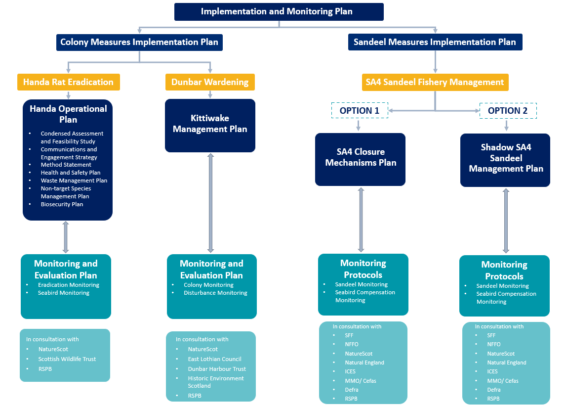
Figure 4 Plans to submitted to Scottish Ministers for Approval, as well as proposed consultees
References
References
Bergstad, O.A., Høines, Å.S. and Krüger-Johnsen, E.M., 2001. Spawning time, age and size at maturity, and fecundity of sandeel, Ammodytes marinus, in the north-eastern North Sea and in unfished coastal waters off Norway. Aquatic Living Resources, 14(5), pp.293-301.
Boulcott, P. et al., 2007. Regional variation in maturation of sandeels in the North Sea. ICES J Mar Sci, 64(2), pp.369 - 376. Available at: https://academic.oup.com/icesjms/article/64/2/369/2182485.
Campbell, S.J., Edgar, G.J., Stuart-Smith, R.D., Soler, G. and Bates, A.E. 2018. Fishing-gear restrictions and biomass gains for coral reef fishes in marine protected areas. Conservation Biology, 32, 401-410.
Cochrane, K.L., and Garcia, S.M. (2009) A Fishery Manager’s Guidebook. The Food and Agriculture Organization of the United Nations and Wiley-Blackwell, Second Edition.
Cohen, P. J., and Alexander, T. J. (2013) Catch Rates, Composition and Fish Size from Reefs Managed with Periodically-Harvested Closures. PLoS ONE 8(9): e73383. doi:10.1371/journal.pone.0073383
Cury, P.M., Boyd, I.L., Bonhommeau, S., Anker-Nilssen, T., Crawford, R.J.M., Furness, R.W., Mills, J.A., Murphy, E.J., Österblom, H., Paleczny, M., Piatt, J.F., Roux, J-P., Shannon, L. and Sydeman, W.J. 2011. Global seabird response to forage fish depletion – one-third for the birds. Science, 334, 1703-1706.
Defra (2021) Call for Evidence on future management of Sandeels and Norway pout. Available at: Call for Evidence on Future Management of Sandeel and Norway pout.pdf (defra.gov.uk) Accessed 03/11/20222
Defra (2019) Marine Strategy Part One: UK Updated assessment and Good Environmental Status. Available at: Marine Strategy Part One: UK updated assessment and Good Environmental Status (publishing.service.gov.uk) Accessed 03/11/2022.
DIISE (2018). The Database of Island Invasive Species Eradications. Island Conservation, Coastal Conservation Action Laboratory UCSC, IUCN SSC Invasive Species Specialist Group, University of Auckland and Landcare Research New Zealand. http://diise.islandconservation.org
Greenstreet, S.P.R. et al., 2006. Variation in the abundance of sandeels Ammodytes marinus off southeast Scotland: an evaluation of area-closure fisheries management and stock abundance assessment methods. ICES J Mar Sci, 63(8), pp.1530 - 1550. Available at: https://academic.oup.com/icesjms/article/63/8/1530/714676.
European Commission (2018). Managing Natura 2000 sites The provisions of Article 6 of the 'Habitats' Directive 92/43/EEC
Gilbert, G., Gibbons, D.W., & Evans, J. (1998). Bird Monitoring Methods. A manual of techniques for key UK species. Spectrum Flair Press, UK. ISBN 1 901930033.
Gullestad, P., Abotnes, A.M., Bakke, G., Skern-Maritzen, M., Nedreaas, K., and Sovik, G. (2017) Towards ecosystem-based fisheries management in Norway – Practical tools for keeping track of relevant issues and prioritising management efforts. Marine Policy, Volume 77, 104-110. A
Humane Vertebrate Pest Control Working Group. (2004). A National Approach Towards Humane Vertebrate Pest Control. An unpublished discussion paper arising from the proceedings of an RSPCA Australia/AWC/VPC joint workshop, August 4-5, Melbourne. RSPCA Australia, Canberra, Australia.
ICES (2010) Report of the Benchmark Workshop on Sandeel (WKSAN), 6–10 September. ICES CM 2010/ACOM:57. Copenhagen, Denmark.
ICES (2017). Report of the Benchmark on Sandeel (WKSand 2016), 31 October - 4 November 2016, Bergen, Norway. ICES CM 2016/ACOM:33. 319 pp.
ICE (2022) ICES Advice on fishing opportunities, catch, and effort. Greater North Sea ecoregion Sandeel (Ammodytesspp.) in divisions 4.a–b, Sandeel Area 4 (northern and central North Sea). Published 25 February 2022
Johnsen, E., Rieucau, G., Ona, E., and Skaret, G. 2017. Collective structures anchor massive schools of lesser sandeel to the seabed, increasing vulnerability to fishery. Marine Ecology Progress Series, 573: 229–236.
Johnsen, E., Sorhus, E., de Jong, K., Lie, K.K., and Grosvik, B.E. (2021) Knowledge status of sea herring in the Norwegian zone of the North Sea. Available at: https://www.hi.no/hi/nettrapporter/rapport-fra-havforskningen-2021-33#sec-9 Accessed 03/11/2022
Lart, W. (2022) Guide to Fisheries Management. Seafish SR741, Version 2.
Lart, W. (2022a) Guide to Fish Stock assessment and ICES reference points. Seafish SR742, Version 2.
Liley, D., and Panter, C. (2017). First year results of monitoring bird disturbance around the Solent, in the presence/absence of rangers. Report prepared by Footprint Ecology for the Solent Bird Aware Initiative.
Macer, C.T., 1966. Sand eels (Ammodytidae) in the south-western North Sea; their biology and fishery.
Marine Scotland (2020) Scotland’s Marine Assessment 2020. Case Study: Sandeels in Scottish Waters. Available at: Case Study: Sandeels in Scottish waters | Scotland's Marine Assessment 2020 Accessed 03/11/2022
McClanahan, T.R., Graham, N.A.J., MacNeil, M.A. and Cinner, J.E. 2014. Biomass-based targets and the management of multispecies coral reef fisheries. Conservation Biology, 29, 409-417.
Natural England (2021). A Natural Capital Account for the Industrial Sandeel Fisheries. Final Report by eftec and ABPmer for Natural England.
Ratcliffe, N., Mitchell, I., Varnham, K., Verboven, N., & Higson, P. (2009). How to prioritise rat management for the benefit of petrels: a case study of the UK, Channel Islands and Isle of Man. Ibis 151: 699-708.
http://www.sciencedirect.com/science/article/pii/S0022098116300247
Scotland’s Future Fisheries Management Strategy.
[1] ‘There is international consensus that ‘one third for the birds’ is an appropriate ecosystem based target as described by Cury et al. (2011). Considering a range of seabirds and different prey fish models indicate a tendency for seabird breeding success to be reduced once forage fish abundance falls below one-third of the long-term maximum abundance of the prey stock. This has been proposed as the “Cury threshold” to maintain forage fish stocks above levels required by dependent predators.