

Recommended safe passing distances and aids to navigation
Safety zones, recommended safe passing distances and Notice to Mariners
- It is standard practice during the construction and operation of an offshore development to communicate with other mariners of safe clearance distances around construction, installation, maintenance and decommissioning activities.
Statutory safety zones
- The legal mechanism for establishing statutory safety zones is discussed in volume 1, chapter 2. The following safety zones will be recommended for the Proposed Development:
- temporary (or rolling) 500 m safety zones surrounding the location of all fixed (surface piercing) structures where work is being undertaken by a construction vessel;
- 50 m safety zones around all surface structures until commissioning where construction work is not active; and
- 500 m around any structure where major maintenance is ongoing (major maintenance- works are defined within the Electricity (Offshore Generating Stations)(Safety Zones) (Application Procedures and Controls of Access) Regulations 2007.
- Statutory decommissioning safety zones will be applied for during the decommissioning phase as appropriate and are not expected to exceed the standard 500 m.
Recommended safe passing distances
Aids to navigation
- The lighting and marking of wind turbines and OSPs/Offshore convertor station platforms to aid navigation will be defined post consent in consultation with the Northern Lighthouse Board (NLB), Marine and Coastguard Agency (MCA), the Civil Aviation Authority (CAA) and the Ministry of Defence (MoD).
- Throughout the lifetime of the Proposed Development, marine aids to navigation will be provided in accordance with the requirements of the NLB, MCA and adherence to Civil Aviation Publication (CAP) 393 Article 223 (CAA, 2016), unless otherwise agreed. All navigational aids associated with the Proposed Development will be suitably monitored and maintained to ensure the relevant CAA availability targets are met.
1.4.5. Operation and Maintenance Phase
Methodology
- The overall operation and maintenance strategy will be finalised once the operation and maintenance base location and technical specification of the Proposed Development are known, including wind turbine type, electrical export option and final project layout.
- This section, therefore, provides a description of the reasonably foreseeable planned and unplanned maintenance activities at the Proposed Development.
- Table 1.31 Open ▸ provides a list of all operation and maintenance activities planned for the Proposed Development.
- The offshore operation and maintenance will be both preventative and corrective. The operation and maintenance strategy will include an onshore (harbour based) operation and maintenance base, supported by a SOV and/or Crew Transfer Vessel (CTV) logistics strategy. This will be developed at a later stage once further detail is confirmed for the Proposed Development.
Table 1.31: Design Envelope: Operation and Maintenance Activities
Operation and maintenance vessels
- The maximum design scenario for operation and maintenance vessel requirements for the Proposed Development are presented in Table 1.32 Open ▸ .
Table 1.32: Design Envelope: Vessels Required During the Operation and Maintenance Activities
1.5. Screening
1.5.1. MPA Screening
- According to the Marine Scotland (2014a) guidelines, section 126 of the MCAA and section 82 of the Marine (Scotland) Act would apply if it is determined through the course of screening that “the proposal is capable of affecting (other than insignificantly) the protected features of the MPA.”
- The Applicant presented a Preliminary MPA Screening for the Proposed Development in the Berwick Bank Wind Farm Offshore Scoping Report (SSER, 2021a). On the basis of the screening criteria outlined in section 1.3.2, three MPAs were identified for initial inclusion on the basis that the Proposed Development was deemed to be potentially capable of affecting (other than insignificantly) a protected feature of the site:
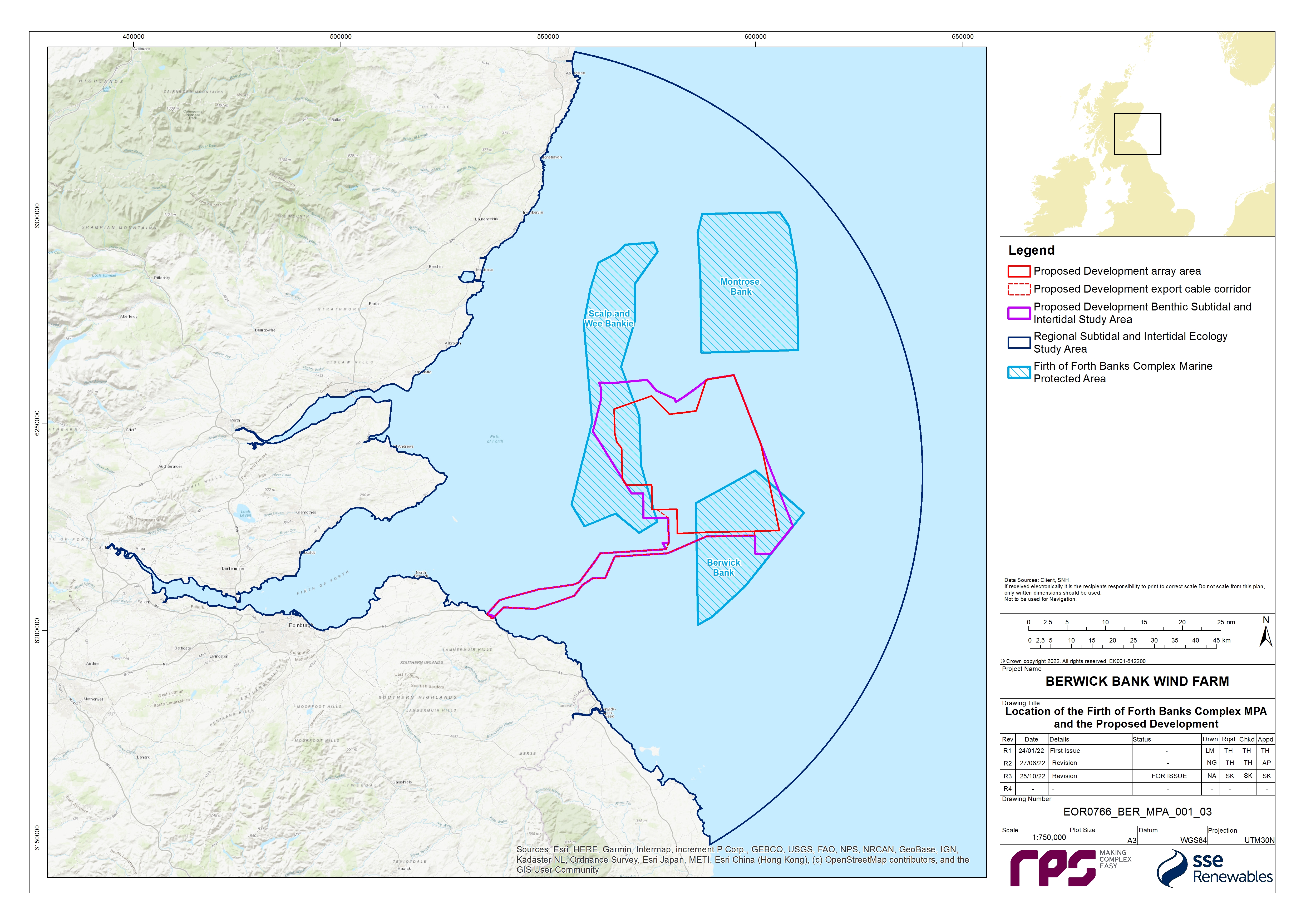
- Firth of Forth Banks Complex MPA (partially overlaps the Proposed Development);
- Turbot Bank MPA (approximately 96 km to the north-east of the Proposed Development array area); and
- Southern Trench MPA (for minke whale only; approximately 99 km to the north of the Proposed Development array area).
- The wide reach of the ornithology regional study area, as described in the screening criteria, includes some MPAs and English MCZs which have seabird/waterfowl features. However, the Proposed Development was not deemed to be potentially capable of affecting (other than insignificantly) a protected ornithological feature of these sites. Similarly, the SNCBs did not raise any issues regarding MPAs/MCZs designated for birds in the Berwick Bank Wind Farm Scoping Opinion (MS-LOT, 2022) and did not suggest that any such sites were considered in the MPA Assessment.
- The Preliminary Screening was, however, revisited following receipt of the Berwick Bank Wind Farm Scoping Opinion (MS-LOT, 2022) and revised on the advice provided by the SNCBs and regulators with regards to fish and marine mammals. As outlined in Table 1.1 Open ▸ , NatureScot and MS-LOT advised that both the Turbot Bank MPA and the Southern Trench MPA could be screened out of the MPA Assessment due to the distance of these sites from the Proposed Development.
- The Firth of Forth Banks Complex MPA site overlaps with the Proposed Development (Figure 1.11). This site, and the impacts upon it, have therefore been considered within this MPA Assessment.
![]()
1.5.2. Screening of Protected Features
- As outlined in paragraph 158 and in the Marine Scotland (2014a) guidelines, following identification of MPAs to be considered, section 126 of the Marine and Coastal Access Act 2009 and section 83 of the Marine (Scotland) Act 2010 would apply if it is determined through the course of screening that “the activity is capable of affecting (other than insignificantly) either (i) any protected feature of a Nature Conservation MPA; or (ii) any ecological or geomorphological process on which the conservation of any protected feature in a Nature Conservation MPA is (wholly or in part) dependent.”
- All of the designated features of the Firth of Forth Banks Complex MPA were identified as having the potential to be affected by the Proposed Development in the Berwick Bank Wind Farm Offshore Scoping Report (SSER, 2021a) and based on the criteria outlined in paragraph 19 have been included due to the MPA’s overlap with the Proposed Development.
- Following the Marine Scotland (2014a) guidelines, any impacts that are concluded in the Offshore EIA Report to have an effect of negligible significance on benthic ecology receptors (including protected features of the MPA) can be screened out and not taken through to the main assessment. Impacts which were concluded to have an effect of negligible significance on protected features of the MPA, within volume 2, chapter 8 of the Offshore EIA Report, are considered to present a sufficiently low risk to these features or the ecological or geomorphological processes on which the conservation of these features are (wholly or in part) dependent, so as to allow these to be screened out at this stage. The following impacts have therefore been screened out and are not considered in the main assessment:
- Temporary habitat disturbance during the operation and maintenance phase for all features except ocean quahog - volume 2, chapter 8 of the Offshore EIA Report predicted an effect of negligible significance on all features of the MPA, with the exception of ocean quahog, due to the short term, temporary nature of the impact, due to the high recovery potential of the habitats and associated communities affected and the highly limited area of seabed predicted to be affected during the operation and maintenance phase;
- Increases in Suspended Sediment Concentration (SSC) and associated sediment deposition during the operation and maintenance phase - volume 2, chapter 8 of the Offshore EIA Report predicted an effect of negligible significance due to the short term, temporary nature of the impact, the high recovery potential of the habitats and associated communities affected and the highly limited area of seabed predicted to be affected during the operation and maintenance phase; and
- Removal of hard substrates resulting in loss of colonising communities during the decommissioning phase - volume 2, chapter 8 of the Offshore EIA Report predicted an effect of minor significance. This impact however would not affect protected features of the MPA because none of the protected features of the MPA would be adversely impacted by the removal of the communities colonising the hard substrates as they all are composed of or rely upon sedimentary habitats. As a result, the effect of this impact is likely to be negligible and therefore it has not been considered further in this MPA Assessment.
- It should be noted that impacts to benthic invertebrates from Electromagnetic Fields (EMFs) were predicted to result in effects of negligible significance in volume 2, chapter 8 of the Offshore EIA Report due to the highly localised nature of the impact and the low sensitivity of the benthic receptors. However, on the basis of advice received from the SNCBs (see Table 1.1 Open ▸ ) this impact pathway has been screened into this MPA Assessment.
- The Marine Scotland (2014a) guidelines also note that many functions and activities can be screened out of the process using generic guidance and evidence on activities which exert pressures on the protected features, which is available through online sensitivity tools. NatureScot’s FeAST online tool has therefore been used to further refine the list of impacts to be included within this MPA Assessment for each of the designated features. On the basis of the FeAST assessments, the following impacts have been screened out where the FeAST tool concludes that the features are not sensitive or not exposed:
- For ocean quahog aggregations, increases in SSC and associated sediment deposition across all phases of the Proposed Development have been screened out on the basis that the FeAST tool concludes that this feature is not sensitive to smothering (siltation changes (low)) and is not exposed to increased SSC (i.e. water clarity changes);
- For the moraines representative of the Wee Bankie key geodiversity area, increases in SSC and associated sediment deposition across all phases of the Proposed Development has been screened out on the basis that the FeAST tool concludes that this feature is not sensitive to increased SSC (i.e. water clarity changes) and smothering (siltation changes (low)) is not relevant to geodiversity features;
- For the moraines representative of the Wee Bankie key geodiversity area, increased risk of introduction and spread of invasive and non-native species (INNS) across all phases of the Proposed Development has been screened out on the basis that the FeAST tool concludes that this pressure is not relevant to geodiversity features;
- For the moraines representative of the Wee Bankie key geodiversity area, colonisation of hard structures has been screened out on the basis that the FeAST tool concludes that this feature is not sensitive to a physical change (to another seabed type);
- For the shelf banks and mounds feature, increased risk of introduction and spread of INNS across all phases of the Proposed Development has been screened out on the basis that the FeAST tool concludes that this pressure is not relevant to geodiversity features; and
- For the shelf banks and mounds feature, colonisation of hard structures has been screened out on the basis that the FeAST tool concludes that this pressure is not relevant to geodiversity features.
1.5.3. Screening Conclusion
- For the Firth of Forth Banks Complex MPA, the following impacts are screened into the main assessment:
- Construction phase:
– temporary habitat disturbance (for all features of the MPA);
– long term subtidal habitat loss (for all features of the MPA); and
- Operation and maintenance phase:
– temporary habitat disturbance (for the following features of the MPA: ocean quahog aggregations);
– long term subtidal habitat loss (for all features of the MPA);
– colonisation of hard structures (for the following features of the MPA: offshore subtidal sands and gravels, ocean quahog aggregations, and shelf banks and mounds);
– increased risk of introduction and spread of INNS (for the following features of the MPA: offshore subtidal sands and gravels and ocean quahog aggregations);
– alteration of seabed habitat arising from effects of physical processes (for all features of the MPA); and
– EMF (for the following features of the MPA: offshore subtidal sands and gravels and ocean quahog aggregations).
- Decommissioning phase:
– temporary habitat disturbance (for all features of the MPA);
– increases in SSC and associated sediment deposition (for the following features of the MPA: offshore subtidal sands and gravels, and shelf banks and mounds);
– permanent subtidal habitat alteration (for all features of the MPA);
– permanent creation of habitat (for the following features of the MPA: offshore subtidal sands and gravels, ocean quahog aggregations, and shelf banks and mounds); and
– increased risk of introduction and spread of INNS (for the following features of the MPA: offshore subtidal sands and gravels and ocean quahog aggregations).
1.6. Background Information on The Firth of Forth Banks Complex MPA
- This section provides a summary of the baseline information for the Firth of Forth Banks Complex MPA considered within the main assessment.
1.6.2. Firth of Forth Banks Complex MPA
- The Firth of Forth Banks Complex MPA, which was designated in July 2014, is located in offshore waters off the east coast of Scotland and covers a total area of 2,130 km2. The MPA is composed of three distinct sections (not connected but in the same area; see Figure 1.11): Berwick Bank (541. 2 km2); Scalp and Wee Bankie (827.1 km2); and Montrose Bank (761.8 km2). Strongly influenced by ocean currents, the mosaic of different types of sands and gravels create a unique mixture of habitats that overlie the underwater banks and mounds within the MPA and support ocean quahog aggregations. The Wee Bankie includes moraines, formed from underwater glacial ridges deposited during the last Ice Age. The moraines are scientifically important for their role in improving the understanding of the history of glaciation around Scotland (JNCC,2018a).
- Volume 3, appendix 8.1 of the Offshore EIA Report provides a detailed description of benthic ecology baseline characterisation within the Proposed Development, including the area overlapping with the Firth of Forth Banks Complex MPA. The baseline was informed by desktop data sources and site-specific surveys (fully detailed in volume 3, appendix 8.1 of the Offshore EIA Report) which were used to characterise the areas of the MPA sections overlapping with the Proposed Development.
- Table 1.33 Open ▸ presents the protected features of the Firth of Forth Banks Complex MPA, with their spatial extents within the MPA (JNCC, 2018b), the condition of the protected feature (JNCC, 2020) and the overarching conservation objectives (JNCC, 2018b). These features, as mapped by the JNCC, are shown relative to the Proposed Development array area and Proposed Development export cable corridor in Figure 1.12. The MPA is characterised by four protected features: ocean quahog aggregations; offshore subtidal sands and gravels; shelf banks and mounds; and moraines (which are representative of the Wee Bankie Key Geodiversity Area).
- Whilst Figure 1.12 represents the offshore subtidal sands and gravels feature as point data only, the JNCC Supplementary Advice on Conservation Objectives for Firth of Forth Banks Complex Nature Conservation MPA (JNCC, 2018b) states that this habitat has been mapped using full coverage bathymetry and backscatter data, as well as benthic video and image sample data, which demonstrated that >99% of the MPA is modelled as offshore subtidal sands and gravels. Offshore subtidal sands and gravels and supporting habitat for ocean quahog aggregations are therefore assumed to extend across the whole of the MPA. The shelf banks and mounds protected feature characterises sizable areas within each of the sections of the MPA and overall covers ~264 km2 within the MPA. The moraines representative of the Wee Bankie key geodiversity area feature occur most extensively in the Scalp and Wee Bankie section of the MPA but are also mapped within Berwick Bank and a small area within Montrose Bank (Figure 1.12); overall this feature covers ~750 km2 of the MPA. Beyond the protected features, the MPA is dominated by Atlantic and Mediterranean moderate energy infralittoral rock and deep circalittoral coarse sediment, with smaller areas of deep circalittoral mixed sediment and deep circalittoral mud.
Table 1.33: Protected Features of the Firth of Forth Banks Complex MPA, Recorded Extents (see Figure 1.12), Condition and Conservation Objectives
- For the Firth of Forth Banks Complex MPA, the conservation objectives for the site are that the protected features:
- so far as already in favourable condition, remain in such condition; and
- so far as not already in favourable condition, be brought into such condition, and remain in such condition.
- extent is stable or increasing;
- structures and functions, quality, and the composition of characteristic biological communities (which includes a reference to the diversity and abundance of species forming part of or living within the habitat) are such as to ensure that they remain in a condition which is healthy and not deteriorating.
- the extent, distribution and structure is maintained;
- the function is maintained to ensure that it continues to support its characteristic biological community (which includes a reference to the diversity of any species associated with the large- scale feature), and their use of the site for, but not restricted to, feeding, courtship, spawning, or use as nursery grounds; and
- the processes necessary to support the feature are maintained.
- For the ocean quahog aggregations protected feature, "favourable condition" is when:
- the quality and quantity of its habitat and the composition of its population in terms of number, age and sex ratio are such as to ensure that the population is maintained in numbers which enable it to thrive.
- For the moraines representative of the Wee Bankie key geodiversity area within the Firth of Forth Banks Complex MPA, "favourable condition" is when:
- its extent, component elements and integrity are maintained;
- its structure and function are unimpaired; and
- its surface remains sufficiently unobscured for the purposes of determining whether the above criteria are satisfied.
- As set out in Table 1.33 Open ▸ , the offshore subtidal sands and gravels and ocean quahog aggregations features need to be recovered to favourable condition (JNCC, 2020). The Supplementary Advice on Conservation Objectives document (JNCC, 2018b) advise that, for the offshore subtidal sands and gravels, this relates to the structure and function attribute and, specifically, the characteristic communities and consequently function. While the feature is naturally exposed to moderate energy levels (due to the tidal currents present in the site), the level of fishing activity present in the site suggests the structure and function of the feature has been impacted as a result of this activity. JNCC consider that the activities which are capable of significantly affecting the protected features of the site and should be managed to prevent further deterioration to offshore subtidal sands and gravels and ocean quahog aggregations are demersal trawling and renewable energy (JNCC, 2020).
- Volume 3, appendix 8.1 of the Offshore EIA Report provides a detailed description of the baseline environment within the Firth of Forth Banks Complex MPA which was informed by desktop data sources and site-specific surveys undertaken for the Proposed Development. It should be noted that the spatial extent of the site-specific benthic subtidal surveys included some areas which, due to refinements to the boundary of the Proposed Development, extend beyond the boundary of Proposed Development benthic subtidal and intertidal ecology study area shown in Figure 1.13. This resulted in some sampling of areas to the north-west, south-west and south-east of the Proposed Development array area, and also inshore areas to the south of the Proposed Development export cable corridor. The data collected from these areas were analysed and included in the baseline characterisation as they provide further context to the data collected within the Proposed Development benthic subtidal and intertidal ecology study area. Samples were collected within the area of the Firth of Forth Banks Complex MPA which overlaps with the benthic subtidal and intertidal ecology study area (Figure 1.11). Within the Berwick Bank section of the MPA, 13 stations were sampled via a combination of grab and drop-down video (DDV), three sites used only DDV sampling and two epibenthic trawls were conducted. Within the Scalp and Wee Bankie section of the MPA, 13 stations were sampled via grab and DDV, one sites used only DDV sampling and two epibenthic trawls were conducted. A geophysical survey campaign was also undergone to characterise the Proposed Development benthic subtidal and intertidal ecology study area including the areas which overlap with the Firth of Forth Banks Complex MPA.
- Figure 1.13 shows the results of the geophysical surveys which indicated that both the Berwick Bank and Scalp and Wee Bankie sections of the MPA, which overlap with the Proposed Development, are characterised by featureless areas as well as sections of ripples and mega ripples, sand waves, ribbons, and bars. The geophysical data also showed areas of trawl marks within both sections of the MPA as well as areas of deposition and erosion. Figure 1.13 also shows the results of the particle size analysis (PSA) which indicated that the sediments within the Berwick Bank part of the MPA which overlaps with the Proposed Development are characterised based on the Folk classification system (Folk, 1954; Long, 2006) described in volume 3, appendix 8.1 of the Offshore EIA Report) as slightly gravelly sand and gravelly sand. The sediments within the Scalp and Wee Bankie part of the MPA which overlap with the Proposed Development are characterised by slightly gravelly sands and sandy gravels with two samples of gravelly sand, one in the north and one in the south. The site-specific data is therefore consistent with the modelled distribution of the offshore subtidal sands and gravels feature within the MPA (i.e. extending across the whole MPA) as presented in the Supplementary Advice on Conservation Objectives document (JNCC, 2018b). This would also, therefore, indicate that the sediments present within the Proposed Development array area represent suitable supporting habitat for ocean quahog. The parts of the Firth of Forth Banks Complex MPA which are outside the Proposed Development array area and Proposed Development export cable corridor were not surveyed as part of the site-specific surveys undertaken for the Proposed Development.
- Figure 1.14 shows the subtidal biotopes mapped within and around the Firth of Forth Banks Complex MPA from the Proposed Development site-specific survey data detailed in paragraph 171. The process by which these biotopes were assigned is fully described in volume 3, appendix 8.1 of the Offshore EIA Report. The part of the Proposed Development which coincides with the Berwick Bank section of the MPA was primarily characterised by the Amphiura filiformis, Mysella bidentata and Abra nitida in circalittoral sandy mud biotope (SS.SMu.CSaMu.AfilMysAnit) with smaller areas of offshore circalittoral sand (SS.SSa.OSa), offshore circalittoral sand with Echinocyamus pusillus (SS.SSa.OSa [Echinocyamus pusillus]), and the Echinocyamus pusillus, Ophelia borealis and Abra prismatica in circalittoral fine sand biotope (SS.SSa.CFiSa.EpusOborApri). The section of the Proposed Development which coincides with the Scalp and Wee Bankie section of the MPA was primarily characterised by the polychaete-rich deep Venus community in offshore mixed sediments biotope (SS.SMx.OMx.PoVen) and the SS.SMu.CSaMu.AfilMysAnit biotope. Smaller areas of the SS.SSa.CFiSa.ApriBatPo biotope, the seapens and burrowing megafauna in circalittoral fine mud biotope (SS.SMu.CFiMu.SpnMeg), the SS.SSa.CFiSa.EpusOborApri biotope, and SS.SSa.OSa were also present. The site-specific data is therefore consistent with the evidence from the MPA designation documents (JNCC, 2014) and the Supplementary Advice on Conservation Objectives document (JNCC, 2018b) which states that the offshore subtidal sands and gravels feature equates to the EUNIS habitats A5.1: Subtidal coarse sediments, A5.2: Subtidal sand, and A5.4: Subtidal mixed sediments.
- Additionally, as previously mentioned within Scalp and Wee Bankie, the site-specific grabs, trawls and DDV sampling recorded two ocean quahogs in the area which overlaps with the Proposed Development array area. The ocean quahog recorded within the MPA during the grab sampling was in the western central section of the Proposed Development array area and was 0.2 cm in size and estimated to be less than a year old. The ocean quahog recorded during the epibenthic trawls was in the north-east of the Proposed Development array area, was 11 cm in size and estimated to be 193 years old (volume 3, appendix 8.1 of the Offshore EIA Report). Again, this is consistent with the sediments within the Proposed Development array area representing suitable supporting habitat for ocean quahog.
- Annex I reef assessments, for both biogenic (e.g. Sabellaria spinulosa) and geogenic reefs, were also conducted within the Proposed Development benthic subtidal and intertidal ecology study area using DDV and in accordance with the latest guidance, however no sites within the Firth of Forth Banks Complex MPA were found to contain Annex I reefs. The nearest potential reef site lay over a kilometre away, north of Berwick Bank at sample site 38 which was found to be a low reefiness (Jenkins et al., 2015; Gubbay, 2007) rocky reef.
- Additionally M. modiolus were recorded in several of the benthic trawls and therefore the full extent of the benthic trawls are presented in Figure 1.14 as the exact location of the M. modiolus is unknown. M. modiolus was recorded within a single trawl in the Berwick Bank section of the Firth of Forth Banks Complex MPA (Figure 1.14).


1.7. Main Assessment – Firth of Forth Banks Complex MPA
1.7.1. Project Alone Assessment
- This section presents the main assessment of the effects of the construction, operation and maintenance and decommissioning of the Proposed Development on the protected features of the Firth of Forth Banks Complex MPA. Each of the impacts identified in the initial screening stage (see section 1.4.3) are discussed individually in the following sections and within each assessment, the effects on attributes and targets of the relevant protected features, and subsequently on the conservation objectives, are considered, using the best available scientific evidence to support the conclusions made.
- Table 1.34 Open ▸ presents a summary matrix of the individual feature attributes of the Firth of Forth Banks Complex MPA considered within each assessment. For the purposes of this assessment, attributes were broadly categorised as either physical or ecological attributes. Table 1.34 Open ▸ provides signposting to the relevant paragraph references of the main assessment below, which provides the justification for the conclusions made with respect to the attributes of the protected features of the Firth of Forth Banks Complex MPA. The colour coding represents the conclusions made within the main assessment of this report. Colour coding is as follows:
- Blue: No significant effect on attribute or target(s);
- Red: Significant effect on attribute or target(s); and
- Grey: No attribute - impact pathway (not applicable).
Table 1.34: Attribute Versus Impact Signposting and Summary Matrix for Stage 1 Assessment of the Proposed Development on the Firth of Forth Banks Complex MPA (Colour Coding Relates to Conclusions with Respect to Impacts Attributes: Blue – No Significant Effect on Attribute or Target(s); and Grey - No Attribute – Impact Pathway)
* Assessment for long term habitat loss/alteration has been combined for the construction and operation and maintenance phases.
Overarching assessment assumptions
- The extent of overlap between the Proposed Development and the Firth of Forth Banks Complex MPA is 331.7 km2, which equates to 15.57% of the total area of the MPA (see Table 1.35 Open ▸ ). This comprises 15.2 km2 within the Proposed Development export cable corridor (0.71% of the MPA area) and 316.5 km2 within the Proposed Development array area (14.86% of the MPA area). This can be further divided between the two sections of the Firth of Forth Banks Complex MPA which overlap with the Proposed Development as follows and summarised in Table 1.35 Open ▸ :
- 229.5 km2 of the Proposed Development overlapping with the Berwick Bank part of the MPA – this equates to 42.42% of the area of the Berwick Bank part of the MPA and represents 69.19% of the Proposed Development overlap with the MPA; and
- 102.2 km2 of the Proposed Development overlaps with Scalp and Wee Bankie – this equates to 12.36% of the area of Scalp and Wee Bankie and represents 30.81% of the Proposed Development overlap with the MPA.
Table 1.35: Summary of the Extent of the Overlap Between the Proposed Development and the Firth of Forth Banks Complex MPA (as a Whole, and for the Component Sites)
Infrastructure within the Firth of Forth Banks Complex MPA
- A total of 331.7 km2 of the Proposed Development array area overlaps with the Firth of Forth Banks Complex MPA, which equates to 31.33% of the total Proposed Development array area. It is assumed that 31.33% of the array area infrastructure could be installed within the MPA (e.g. the maximum design scenario for long term habitat loss under foundations assumes that 56 of the total 179 foundations for a larger wind turbine scenario could be installed within the Firth of Forth Banks Complex MPA); and
- 13.08% of the Proposed Development export cable corridor overlaps with the Firth of Forth Banks Complex MPA and therefore it is assumed that 13.08% of offshore export cables could be installed within the MPA.