

8. Benthic Subtidal and Intertidal Ecology
8.1. Introduction
- This chapter of the Offshore Environmental Impact Assessment (EIA) Report presents the assessment of the likely significant effects (as per the “EIA Regulations”) on the environment of the Berwick Bank Wind Farm offshore infrastructure which is the subject of this application (hereafter referred to as “the Proposed Development”) on benthic subtidal and intertidal ecology. Specifically, this chapter considers the likely significant effects of the Proposed Development seaward of Mean High Water Springs (MHWS) during the construction, operation and maintenance, and decommissioning phases.
- Likely significant effect is a term used in both the “EIA Regulations” and the Habitat Regulations. Reference to likely significant effect in this Offshore EIA Report refers to “likely significant effect” as used by the “EIA Regulations”. This Offshore EIA Report is accompanied by a Report to Inform Appropriate Assessment (RIAA) (SSER. 2022c) which uses the term as defined by the Habitats Regulations Appraisal (HRA) Regulations.
- The assessment presented is informed by the following technical chapters:
- volume 2, chapter 7: Physical Processes; and
- volume 2, chapter 9: Fish and Shellfish Ecology.
- This chapter summarises and draws on information contained within the Benthic Subtidal and Intertidal Ecology Technical Report (refer to volume 3, appendix 8.1) which provides a detailed characterisation of the benthic ecology of the benthic subtidal and intertidal ecology study area based on a desktop review and site-specific benthic surveys.
8.2. Purpose of this Chapter
- The primary purpose of the Offshore EIA Report is outlined in volume 1, chapter 1. It is intended that the EIA Report will provide the Scottish Ministers, statutory and non-statutory stakeholders with sufficient information to determine the likely significant effects of the Proposed Development on the receiving environment.
- In particular, this Benthic Subtidal and Intertidal Ecology Offshore EIA Report chapter:
- presents the existing environmental baseline established from desk studies, and site-specific surveys;
- identifies any assumptions and limitations encountered in compiling the environmental information;
- presents the likely significant environmental impacts on benthic subtidal and intertidal ecology arising from the Proposed Development and reaches a conclusion on the likely significant effects on benthic subtidal and intertidal ecology, based on the information gathered and the analysis and assessments undertaken; and
- highlights any necessary monitoring and/or mitigation measures which are recommended to avoid, prevent, minimise, reduce, or offset the likely significant adverse environmental effects of the Proposed Development on benthic subtidal and intertidal ecology.
8.3. Study Area
- For the purposes of the benthic subtidal and intertidal ecology assessment, two study areas have been defined as follows.
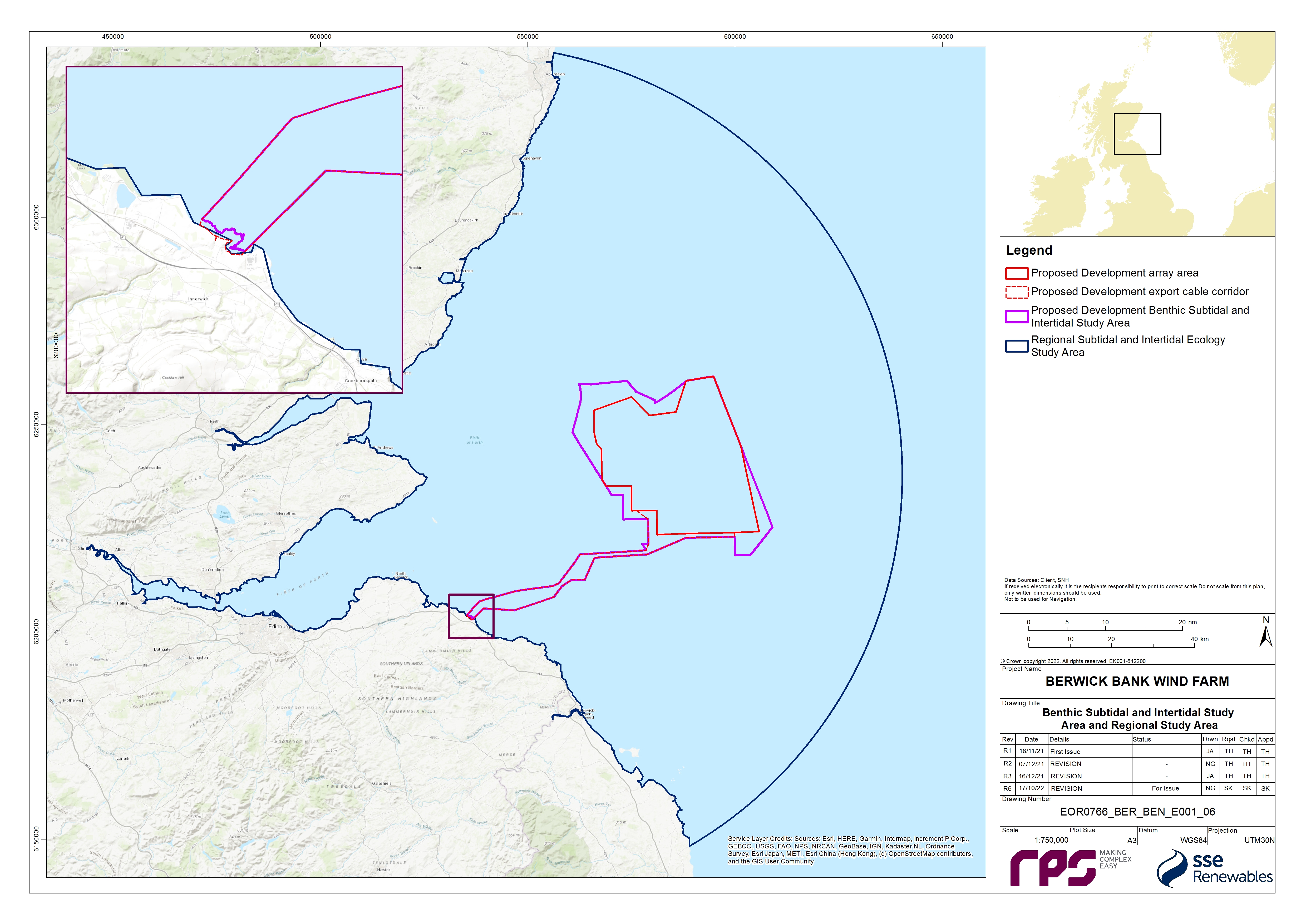
- The benthic subtidal and intertidal ecology study area has been defined as the area encompassing the Proposed Development array area, the Proposed Development export cable corridor (including intertidal habitats up to MHWS) and associated landfall. This is the area within which the site-specific benthic subtidal and intertidal surveys were undertaken ( Figure 8.1 Open ▸ ). The benthic subtidal and intertidal ecology study area extends to encompass a large area at the shore as two landfall sites were originally investigated, and one was subsequently removed from consideration. It should be noted that the spatial extent of the site-specific benthic subtidal surveys included some areas which, due to refinements to the boundary of the Proposed Development, extend beyond the boundary of Proposed Development benthic subtidal and intertidal ecology study area shown in Figure 8.1 Open ▸ . This resulted in some sampling of areas to the north-west, south-west and south-east of the Proposed Development array area, and also inshore areas to the south of the Proposed Development export cable corridor. The data collected from these areas were analysed and included in the baseline characterisation as they provide further context to the data collected within the Proposed Development benthic subtidal and intertidal ecology study area.
- The regional benthic subtidal and intertidal ecology study area encompasses the wider northern North Sea habitats and includes the neighbouring consented offshore wind farms and designated sites. It has been characterised by desktop data and has been used to provide a wider context to the site-specific data.
- Both study areas were discussed and agreed with the statutory consultees ( Table 8.5 Open ▸ ) as part of the Road Map process (see volume 3, appendix 8.2), and the regional benthic subtidal and intertidal ecology study area was reduced in size from a larger area which covered a wider section of the North Sea, on advice from Marine Scotland Science and NatureScot.
- The offshore topic of benthic subtidal and intertidal ecology study includes the intertidal area. This intertidal area overlaps with the onshore topic of ecology and ornithology (landward of MLWS).
8.4. Policy and Legislative Context
- Policy and legislation on renewable energy infrastructure is presented in volume 1, chapter 2 of the Offshore EIA Report. Policy and legislation specifically in relation to benthic subtidal and intertidal ecology, is contained in Scotland’s National Marine Plan (Scottish Government, 2015), the Sectoral Marine Plan for Offshore Wind Energy (Marine Scotland Science, 2011), the Sectoral Marine Plan for Offshore Wind Energy (Scottish Government, 2020) and the United Kingdom (UK) Marine Policy Statement. A summary of the legislative provisions relevant to benthic intertidal and subtidal ecology are provided in Table 8.1 Open ▸ , with other relevant policy provisions set out in Table 8.2 Open ▸ to Table 8.4 Open ▸ .
Table 8.1: Summary of Habitat Regulations (Conservation of Offshore Marine Habitats and Species Regulations 2017, Conservation (Natural Habitats, &c.) Regulations 1994 and Conservation of Habitats and Species Regulations 2017). Relevant to Benthic Subtidal and Intertidal Ecology
Table 8.2: Summary of the Scottish National Marine Plan Relevant to Benthic Subtidal and Intertidal Ecology
Table 8.4: Summary of the UK Marine Policy Statement Relevant to Benthic Subtidal and Intertidal Ecology
8.5. Consultation
- The Benthic Subtidal and Intertidal Ecology Road Map was a ‘live’ document which has been used as a tool to facilitate early engagement with stakeholders and subsequent engagement throughout the pre-application phase of the Proposed Development including reaching points of agreement on scoping impacts out of the assessment, and/or agreeing the level of assessment which will be presented for impacts, so that the focus in the Offshore EIA Report submission documents is on likely significant environmental effects as defined by the EIA Regulations.
- The Benthic Ecology, Fish and Shellfish Ecology and Physical Processes Road Map (up to date at the point of Application) is presented as volume 3, appendix 8.2 and documents meetings and discussion points. At the request of Marine Scotland – Licensing Operations Team (MS-LOT)[1], an Audit Document for Post-Scoping Discussions (volume 3, appendix 5.1) has been produced to document discussions on key issues, post-receipt of the Berwick Bank Wind Farm Scoping Opinion (MS-LOT, 2022).
- A summary of the key issues raised during consultation activities undertaken to date specific to benthic subtidal and intertidal ecology is presented in Table 8.5 Open ▸ , together with how these issues have been considered in the production of this Benthic Subtidal and Intertidal Ecology Offshore EIA Report chapter. Further detail is presented within volume 1, chapter 5.
Table 8.5: Summary of Key Consultation of Relevance to Benthic Subtidal and Intertidal Ecology
8.6. Methodology to Inform Baseline
8.6.1. Desktop Study
- Information on benthic subtidal and intertidal ecology within the regional benthic subtidal and intertidal ecology study area was collected through a detailed desktop review of existing studies and datasets. These are summarised in Table 8.6 Open ▸ .
Table 8.6: Summary of Key Desktop Reports
8.6.2. Designated Sites
- All designated sites and qualifying interest features that could be affected by the construction, operation and maintenance, and decommissioning phases of the Proposed Development were identified using the three-step process as described here:
- Step 1: All designated sites of international, national, and local importance within the regional benthic subtidal and intertidal ecology study area were identified using a number of sources. These sources included the JNCC MPA mapper, and the Marine Scotland Science NMPI maps.
- Step 2: Information was compiled on the relevant IEFs for each of these sites.
- Step 3: Using the above information and expert judgement, sites were included for further consideration if:
– a designated site directly overlaps with the Proposed Development array area and the Proposed Development export cable corridor; and/or
– sites and associated features were located within the potential Zone of Influence (ZoI) for impacts associated with the Proposed Development.
- The ZoI was defined through modelling undertaken in volume 3, appendix 7.1. The ZoI identified designated sites within one tidal excursion (12 km) of the Proposed Development array area and Proposed Development export cable corridor and are therefore at the maximum range of the impacts of the Proposed Development.
8.6.3. Site-Specific Surveys
- To inform the Benthic Subtidal and Intertidal Ecology Offshore EIA Report chapter, site-specific surveys were undertaken, as agreed with the NatureScot, MS-LOT and MSS (see volume 3, appendix 8.1 for further details). A summary of the surveys undertaken to inform the benthic subtidal and intertidal ecology assessment of effects are outlined in Table 8.7 Open ▸ .
Table 8.7: Summary of Site-Specific Survey Data
8.7. Baseline Environment
8.7.1. Overview of Baseline Environment
Seabed sediments
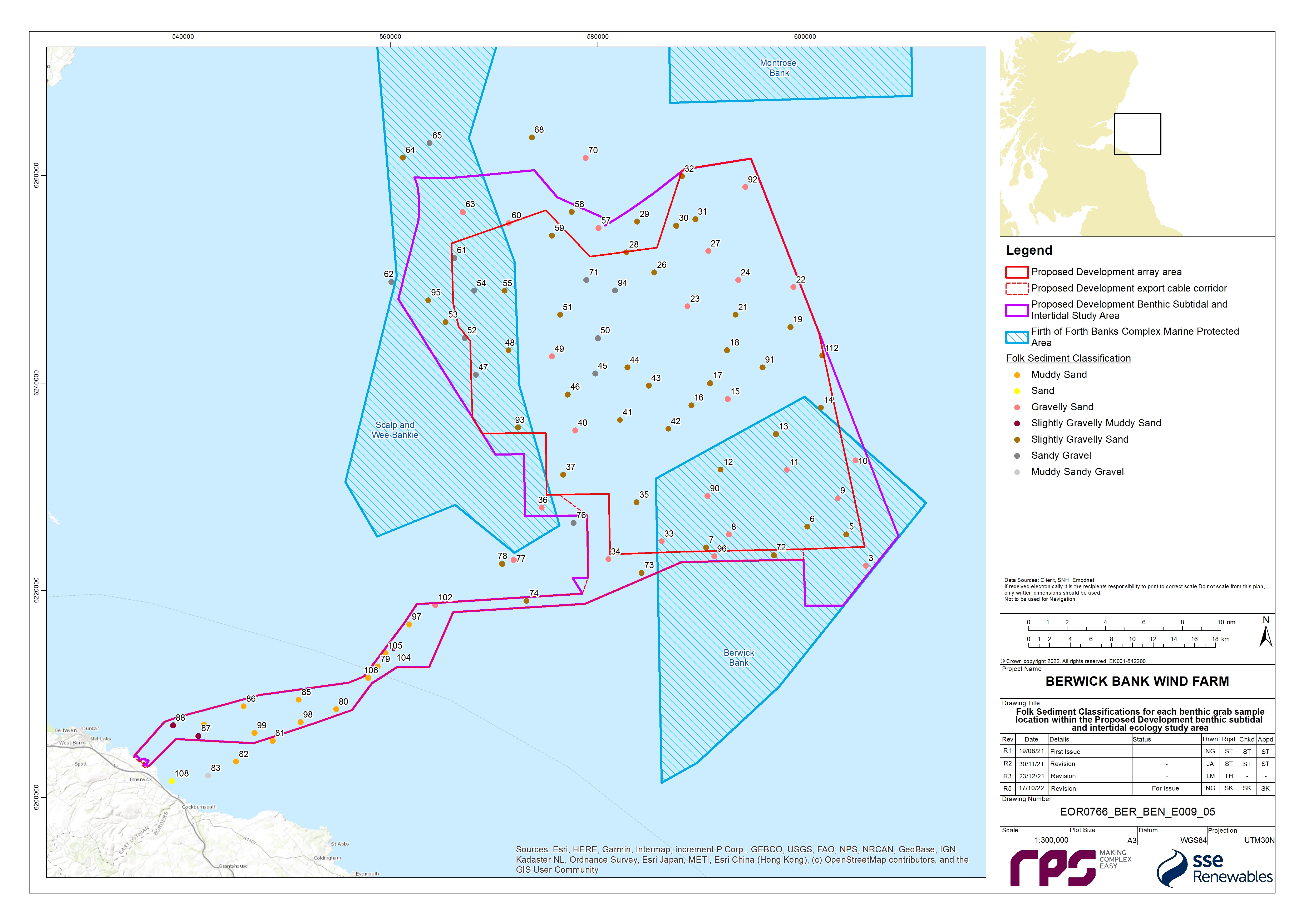
- The subtidal sediments recorded across the benthic subtidal and intertidal ecology study area range from sandy gravel to muddy sand with most samples taken during the site-specific benthic surveys classified as slightly gravelly sand ( Figure 8.2 Open ▸ ). The geophysical survey recorded extensive boulder fields across the broad topographic highs and the banks. This geophysical data also showed that the majority of the seabed is ‘featureless’, however the southern and north-western extent of the Proposed Development array area is dominated by megaripples, sand waves, ribbons and bars.
- The sediments within the eastern parts of the Proposed Development array area are dominated by slightly gravelly sands with areas of gravelly sand in the north and south. The site-specific survey data showed that the sediments within the eastern part of the Proposed Development array area are characterised by slightly gravelly sand with areas of gravelly sand in the north and south ( Figure 8.2 Open ▸ ). The sediments within the western part of the Proposed Development array area are typically slightly coarser and characterised by sandy gravel sediments in addition to slightly gravelly sand and gravelly sand ( Figure 8.2 Open ▸ ). Generally, sand makes up the highest proportion of the sediment composition, with the exception of a few samples within the western section of the Proposed Development array area which are dominated by gravel, some of which overlap with the Berwick Bank morphological features. This is aligned with the site-specific surveys’ seabed sediment results. Sediments from within the FFBC MPA are generally representative of the sediments recorded across the benthic subtidal and intertidal ecology study area.
- The sediments within the offshore section of the Proposed Development export cable corridor are characterised by muddy sand sediments which grade into slightly gravelly muddy sand, and rocky habitats with increasing proximity to the landfall ( Figure 8.2 Open ▸ ). The sample stations with the highest percentage composition of mud are generally found along the inshore section of the Proposed Development export cable corridor.
- The Skateraw landfall (which forms part of the Proposed Development) is characterised by a rock platform which is predominantly covered by sediments. A sandy bay is present at Skateraw beach which is mainly composed of fine and medium grained sand which becomes muddier at the lower shore. Larger mobile sediments (pebbles, cobbles and boulders) cover the rest of the rock platform with exposed areas of bedrock occurring in places. Additionally, some areas of bedrock contain a mosaic of deep pools cut into the sedentary platform by wave action. Rockpools frequently occur in this rocky zone. Cobbles and boulders dominate the mid to lower shore with fucoid seaweeds. Kelp beds are present in the lower shore, either attached to boulders or direct to bedrock. Pebbles and cobbles are present throughout the rocky areas of the landfall forming the beach head in the northern section of the landfall.
Sediment contamination
- Nine sediment samples from across the Proposed Development benthic subtidal and intertidal ecology study area were analysed for sediment chemistry. This analysis evaluated levels of heavy metals, organotin (dibutyltin and tributyltin), polychlorinated biphenyls, and polycyclic aromatic hydrocarbons which were then compared to the Marine Scotland Science chemical guideline Action Level 1 (AL1)/Action Level 2 (AL2) and the Canadian Sediment Quality Guidelines (CSQG; CCME, 2001). No contaminants were found to exceed AL1/AL2 or the Canadian Probable Effect Level (PEL). Only arsenic at five sample stations within the north-west of the Proposed Development array area exceeded the Canadian Threshold Effect Level (TEL).
Subtidal biotopes and habitats
- Across the benthic subtidal and intertidal ecology study area, the infaunal communities are generally dominated by annelids, molluscs and crustaceans. The most abundant individuals generally belong to Mollusca and Annelida although the tunicate Dendrodoa grossularia is overall the most abundant species. The biomass data does not reflect the dominance of Annelida with respect to the number of individuals and number of taxa, with Annelida providing the highest proportion of the biomass at only 18% of sample stations. Mollusca contribute the highest proportion of biomass at the greatest number of sample stations (45%).
- The epifaunal communities recorded by the seabed imagery are dependent on the type of sediment. In general, high numbers of epifaunal species were recorded in association with the coarser sediments. The epifaunal species recorded were dominated by crustaceans and cnidarians with low numbers of molluscs and polychaetes, however this may be due to the nature of video sampling, as most polychaetes are infaunal species therefore would not be visible to DDV sampling. Samples with coarse and mixed sediments were found associated with the presence of dead man’s fingers Alcyonium digitatum, acorn barnacles common rock barnacle Semibalanus balanoides, common starfish Asterias rubens and the polychaete Spirobranchus species.
- The epibenthic trawl analysis showed a total of 69 taxa were recorded from the 15 epibenthic trawls undertaken across the Proposed Development benthic subtidal and intertidal ecology study area. The epibenthic trawl communities were found to be generally dominated by Crustacea which contributed 73.87% to the total number of individuals and 40.42% of the total taxa. Within the Crustacea taxa the most abundant individual was brown shrimp Crangon crangon.
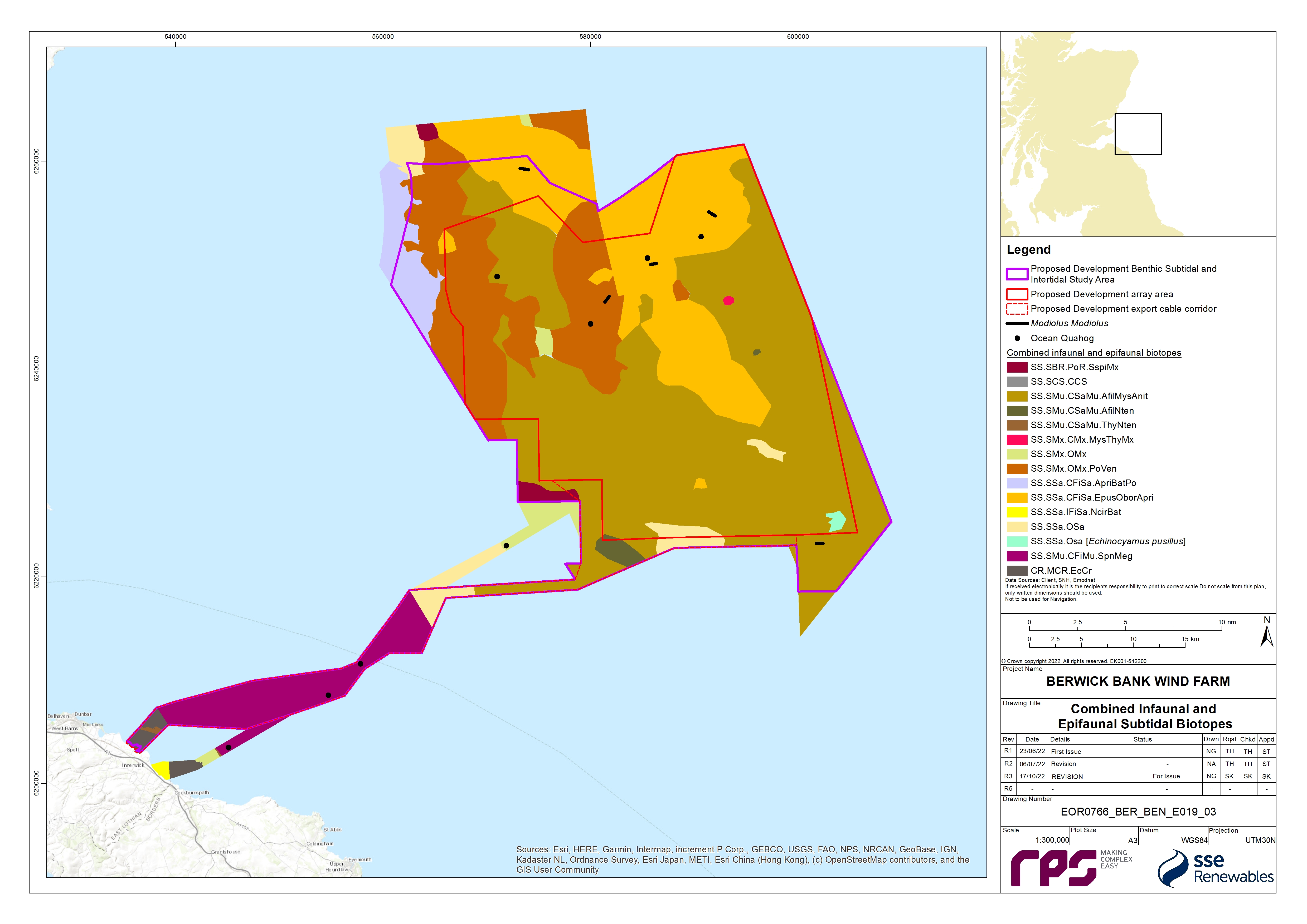
- The distribution of combined infaunal and epifaunal biotopes is presented in Figure 8.3 Open ▸ . The eastern section of the Proposed Development array area is characterised by Amphiura filiformis, Mysella bidentata and Abra nitida in circalittoral sandy mud (SS.SMu.CSaMu.AfilMysAnit) and Echinocyamus pusillus, Ophelia borealis and Abra prismatica in circalittoral fine sand (SS.SSa.CFiSa.Epus.OborApri) biotopes. There is also a small area of circalittoral sand with pea urchin (SS.SSa.OSa [Echinocyamus pusillus]) biotope in the south east and small area of Mysella bidentata and Thyasira spp. in circalittoral muddy mixed sediment (SS.SMx.CMx.MysThyMx) in the east of the Proposed Development array area. The western section of the Proposed Development array area is characterised by the polychaete-rich deep Venus community in offshore mixed sediments (SS.SMx.OMx.PoVen), and SS.SMu.CSaMu.AfilMysAnit. Just beyond the north-western boundary of the Proposed Development benthic subtidal and intertidal ecology study area the communities are characterised by the Abra prismatica, Bathyporeia elegans and polychaetes in circalittoral fine sand (SS.SSa.CFiSa.ApriBatPo) biotope. The Proposed Development export cable corridor is characterised by the SS.SMu.CSaMu.AfilMysAnit biotope in proximity to the boundary of the Proposed Development array area and by the seapens and burrowing megafauna in circalittoral fine mud (SS.SMu.CFiMu.SpnMeg) biotope in the central section. Mixed sediments and the echinoderms and crustose communities (CR.MCR.EcCr) biotope on rock were recorded in the inshore areas adjacent to the landfall.
Intertidal biotopes and habitats
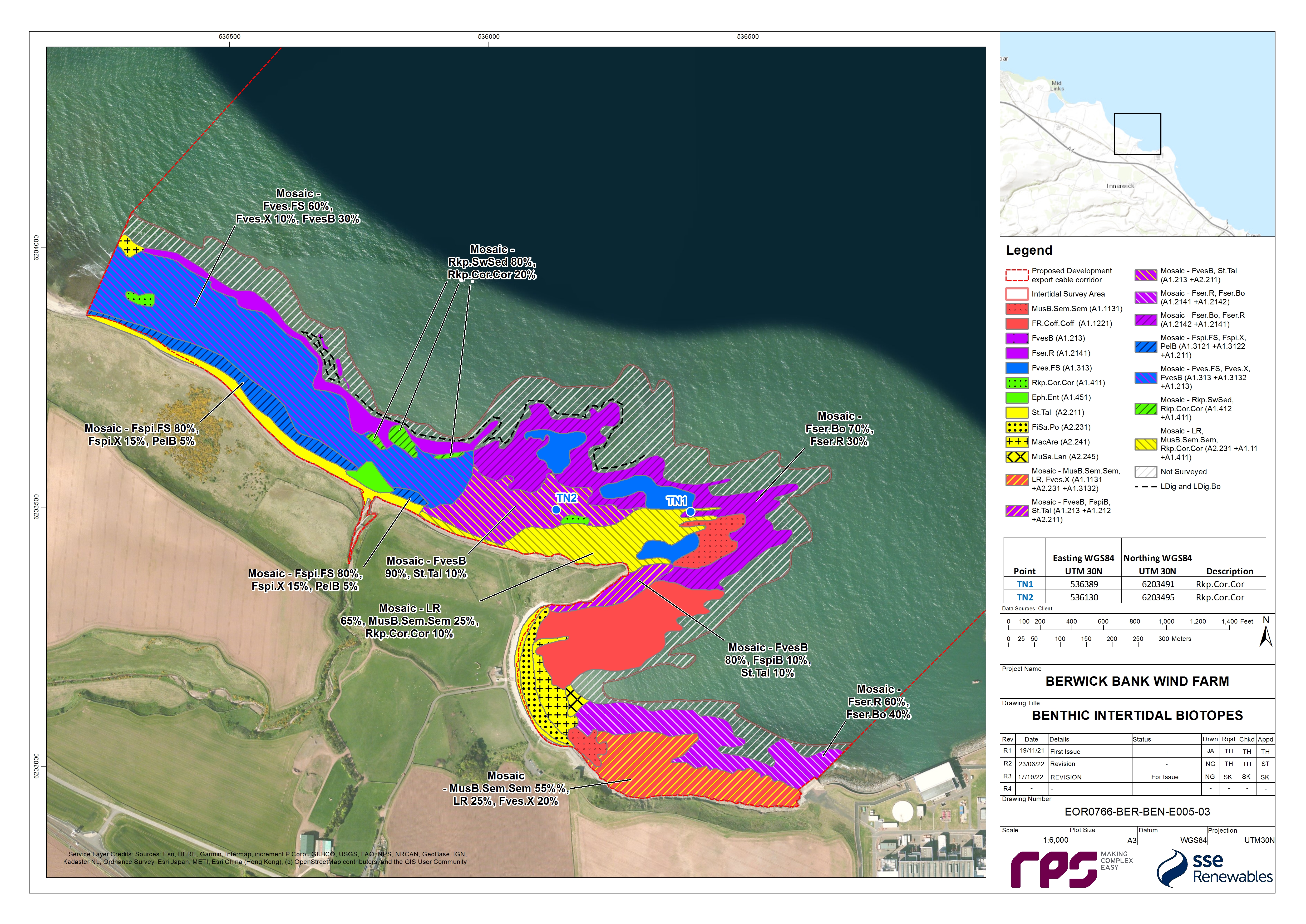
- The distribution of biotopes at the Skateraw landfall site is displayed in Figure 8.4 Open ▸ . The drift line though fairly sparse is characterised by super abundant talitrid amphipods representing the biotope talitrids on the upper shore and strand-line (LS.Lsa.St.Tal). The biotope yellow and grey lichens on supralittoral rock (LR.FLR.Lic.YG) occurs sparsely. Verrucaria maura tar lichen on littoral rock fringe (LR.FLR.Lic.Ver) occurs on upper shore bedrock, boulders and cobbles.
- The mid shore of the Skateraw landfall contains a patchwork of related biotopes, most of which are dominated by fucoids. The biotope Semibalanus balanoides, Patella vulgata and Littorina spp. on exposed to moderately exposed or sheltered vertical eulittoral rock (LR.HLR.MusB.Sem.Sem) occurs on bedrock and boulders and hosted a variety of fauna. The biotope Fucus vesiculosus and barnacle mosaics on moderately exposed mid eulittoral rock (LR.MLR.BF.FvesB) occurs predominantly on mixed rocky sediments dominated by boulders and also on bedrock. The biotope Corallina officinalis and Mastocarpus stellatus on exposed to moderately exposed lower eulittoral rock (LR.HLR.FR.Coff.Coff) is dominated by coral weed C. officinalis and coralline crusts with abundant bladder wrack F. vesiculosus. Numerous examples of the biotope coral weed and coralline crusts in shallow eulittoral rockpools (LR.FLR.Rkp.Cor.Cor) occur from the middle of the shore up to the F. spiralis zone.
- The biotope Fucus serratus on moderately exposed lower eulittoral rock (LR.MLR.BF.Fser) occurs commonly on the lower shore of the Skateraw landfall. Areas of the biotope F. serratus and under-boulder fauna on exposed to moderately exposed lower eulittoral boulders (LR.MLR.BF.Fser.Bo) and Laminaria digitata and under-boulder fauna on sublittoral fringe boulders (LR.MIR.KR.Ldig.Bo) are highly species rich with super abundant toothed wrack F. serratus and occasionally bladder wrack. Toothed wrack and the kelp L. digitata dominate the deeper waters of fucoids and kelp in deep eulittoral rockpools (LR.FLR.Rkp.FK) while coral weed and coralline crusts dominate the shallow fringes. Rockpools are predominantly characterised by the seaweeds in sediment-floored eulittoral rockpools (LR.FLR.Rkp.SwSed) biotope and large pools even contain patches of Macoma balthica and Arenicola marina in littoral muddy sand (LS.LSa.MuSa.MacAre) biotope complete with an anoxic layer.
- The biotope Macoma balthica and A. marina in littoral muddy sand (LS.LSa.MuSa.MacAre) occurs in upper shore and mid shore areas within the sandy bay at Skateraw beach. Where dense populations of sand mason worm Lanice conchilega occur and lugworm is less abundant, if present, the biotope L. conchilega in littoral sand (LS.LSa.MuSa.Lan) has been ascribed.
- In the intertidal zone at the Skateraw landfall site there are a number of habitats of conservation importance which are protected under the Conservation (Natural Habitats, &c.) Regulations 1994. These include biotopes found on sand and mudflats (e.g. LS.Lsa.St.Tal, and LS.LSa.MuSa.MacAre). Furthermore, the biotopes LR.MLR.BF.Fser.Bo and IR.MIR.KR.Ldig.Bo found in intertidal boulder communities are habitats that are listed on the Scottish Biodiversity List.
Habitat assessments
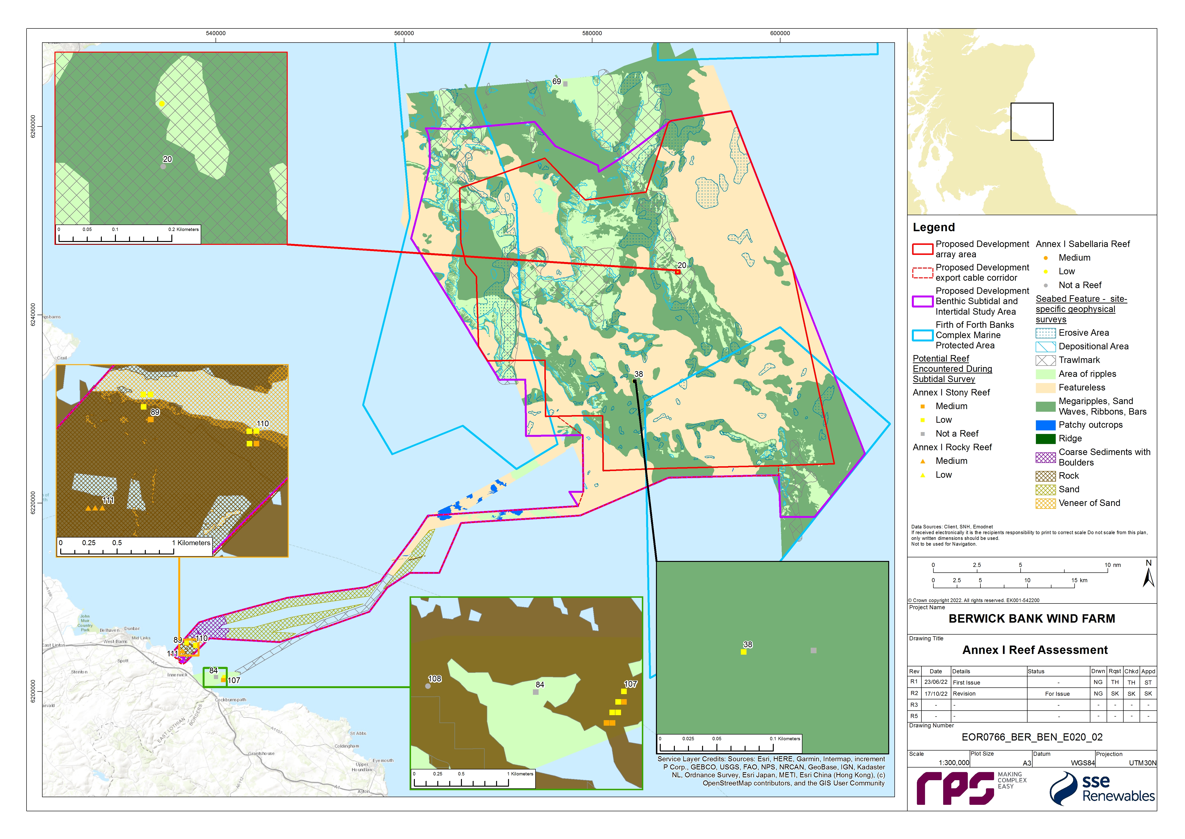
- Several seabed habitats were taken forward for further assessment to determine their potential to align with features of conservation habitats. A cobble/stony reef assessment was performed at 11 sites. These sites were found in the eastern and north-west regions of the Proposed Development array area, and in the nearshore section of the Proposed Development export cable corridor ( Figure 8.5 Open ▸ ). All the sample stations in the Proposed Development array area were classified as ‘not a reef’ or low reefiness as they all had an extent of <25 m2 and/or composition of <25% (Irving, 2009 and Jenkins et al., 2015). Therefore, it is unlikely that this would be considered Annex I cobble/stony reef habitat. Two of the stations in the Proposed Development export cable corridor, within 3 km of the Skateraw landfall, were assessed to be medium potential reef and therefore are considered to be Annex I cobble/stony reef habitat.
- One sample station in the nearshore area of the Proposed Development export cable corridor was classified as medium potential Annex I rocky reef ( Figure 8.5 Open ▸ ). The desktop data reported discrete areas of rock distributed throughout the inshore regions of the Proposed Development export cable corridor (Inch Cape Offshore Limited, 2011; EMODnet, 2019).
- A S. spinulosa reef assessment was required at three sites. These habitats were identified from the DDV and seabed imagery. The reef assessment classified two sites (ST04 and ST56) as ‘not a reef’; these areas cannot therefore be considered Annex I S. spinulosa reef habitat. A single site in the centre of the Proposed Development array area (ST20) was assigned a low reefiness score (Jenkins et al., 2015 and Gubbay, 2007) ( Figure 8.5 Open ▸ ).
- A seapen and burrowing megafauna community’s assessment was conducted on the DDV sample stations where the seapen and burrowing megafauna biotope was indicated ( Figure 8.3 Open ▸ ). Burrows were observed at 14 sample stations within the seabed stills and DDV footage. Seapens were observed at 11 of these stations but there was no indication of megafauna being present as all the burrows in the images were small in size (<1 cm). For most of the sample stations where burrows were present in the DDV footage, burrow density was classified as ‘common’ according to the SACFOR[2] scale. In accordance with the JNCC (2014) guidance, they were classified as a prominent feature of the site (frequent on the SACFOR scale is required for burrows to be classified as a prominent feature). It was therefore concluded that the 14 stations within the mid-section of the Proposed Development export cable corridor qualify as the ‘seapen and burrowing megafauna communities’ OSPAR habitat.
Species of conservation importance
- Ocean quahog were recorded in the benthic infaunal grab survey and the epibenthic trawls. The FFBC MPA is designated for ocean quahog aggregations and this species is listed on the OSPAR list of threatened and/or declining species and habitats (OSPAR, 2008). In addition, ocean quahog is a species listed as a Scottish PMF (Tyler-Walters et al., 2016). Ocean quahog individuals were recorded in eight grab samples across the Proposed Development array area and the Proposed Development export cable corridor (as shown in Figure 8.3 Open ▸ ), as well as in two epibenthic trawls in, and around, the Proposed Development array area. Most individuals recorded were juveniles (less than one year old) however four were mature specimens (estimated to be 192, 16, 166 and 193 years old). These four ocean quahog were recorded from the northern and central sections of the Proposed Development array area. One juvenile ocean quahog was recorded within the FFBC MPA.
- Horse mussel Modiolus modiolus individuals were recorded in five of the epibenthic trawls mostly at low densities except at one station in the centre of the benthic subtidal and intertidal ecology study area where 31 individuals where recorded. No M. modiolus beds were recorded during the DDV survey and no M. modiolus was recorded in the infaunal grab survey. M. modiolus were recorded in several of the benthic trawls and therefore the full extent of the benthic trawls is presented in Figure 8.3 Open ▸ as the exact location of the M. modiolus is unknown.

8.7.2. Designated Sites
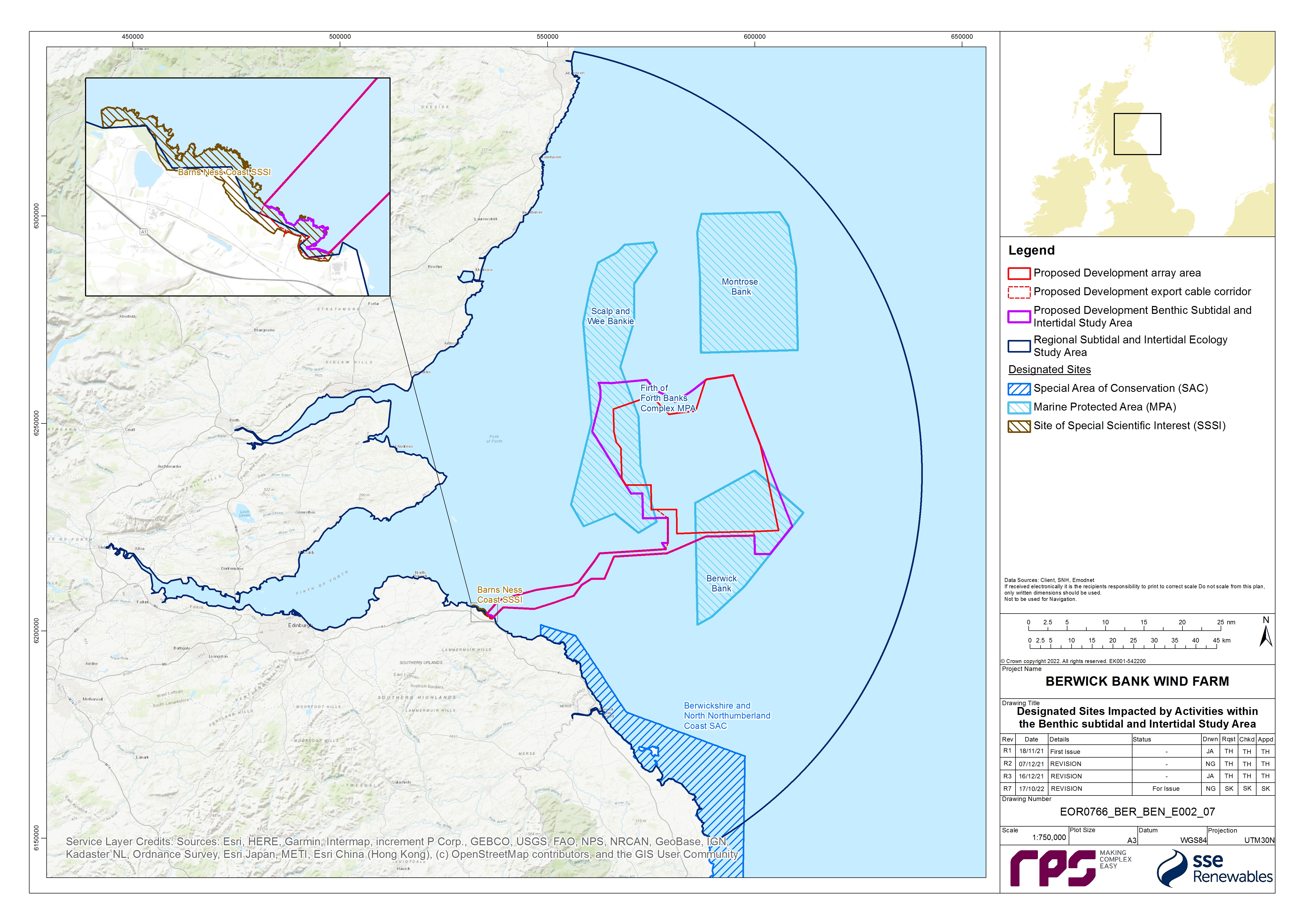
- Designated sites identified for the Benthic Subtidal and Intertidal Ecology Offshore EIA chapter are described in Table 8.8 Open ▸ . The location of these sites can be seen in Figure 8.6 Open ▸ . These sites have been identified to be within one tidal excursion (12 km) of the Proposed Development array area and Proposed Development export cable corridor and are therefore at the maximum range of the impacts of the Proposed Development. On the basis of the advice received from NatureScot in the Berwick Bank Wind Farm Scoping Opinion (MS-LOT, 2022 (see Table 8.5 Open ▸ )), the Firth of Forth SSSI, and the Berwickshire Coast (Intertidal) SSSI were subsequently screened out on the basis of no spatial overlap. With regards to European sites, as per the Berwick Bank Wind Farm Offshore HRA Screening Report (SSER, 2021b) and the Berwick Bank Wind Farm Scoping Opinion (MS-LOT, 2022) (see Table 8.5 Open ▸ ), only the Berwickshire and North Northumberland Coast SAC has been included.
Table 8.8: Designated Sites and Relevant Qualifying Interest Features for the Benthic Subtidal and Intertidal Ecology Chapter
8.7.3. Important Ecological Features
- In accordance with the best practice guidelines (CIEEM, 2019), for the purposes of the benthic subtidal and intertidal ecology EIA, IEFs have been identified. The likely significant effects of the Proposed Development which have been scoped into the assessment (see section 8.8) have been assessed against the IEFs to determine whether or not they are significant. The IEFs assessed are those that are considered to be important and potentially affected by the Proposed Development. Importance may be assigned due to quality or extent of habitats, habitat or species rarity or the extent to which they are threatened (CIEEM, 2019). Species and habitats are considered IEFs if they have a specific biodiversity importance recognised through international or national legislation or through local, regional, or national conservation plans (e.g. Annex I habitats under the Habitats Directive, OSPAR, National Biodiversity Plan or the Marine Strategy Framework Directive, Scottish PMFs and the Scottish Biodiversity list).
- All of the IEFs within the Proposed Development benthic subtidal and intertidal ecology study area are listed in Table 8.9 Open ▸ . The main habitats identified throughout the Proposed Development benthic subtidal and intertidal ecology study area comprise seven broad subtidal IEFs and three broad intertidal IEFs. The IEFs that comprise features of MPAs have also been assessed.
Table 8.9: IEFs within the Project Development Benthic Subtidal and Intertidal Ecology Study Area
8.7.4. Future Baseline Scenario
- The EIA Regulations ((The Electricity Works (Environmental Impact Assessment) (Scotland) Regulations 2017, The Marine Works (Environmental Impact Assessment) (Scotland) Regulations 2017, the Marine Works (Environmental Impact Assessment) Regulations 2007 and The Town and Country Planning (Environmental Impact Assessment) (Scotland) Regulations 2017)), require that a “a description of the relevant aspects of the current state of the environment (baseline scenario) and an outline of the likely evolution thereof without development as far as natural changes from the baseline scenario can be assessed with reasonable effort, on the basis of the availability of environmental information and scientific knowledge” is included within the Offshore EIA Report.
- In the event that the Proposed Development does not come forward, an assessment of the future baseline conditions has been carried out and is described within this section.
- Further to potential change associated with existing cycles and processes, it is necessary to take account of potential effects of climate change on the marine environment. Variability and long term changes on physical influences may bring direct and indirect changes to benthic habitats and communities in the mid to long term future (Department of Energy and Climate Change (DECC), 2016). A strong base of evidence indicates that long term changes in the benthic ecology may be related to long term changes in the climate or in nutrients (DECC, 2016), with climatic process driving shifts in abundances and species composition of benthic communities (Marine Climate Change Impacts Partnership (MCCIP), 2015). Benthic communities are also predicted to be influenced by anthropogenic activities including, contamination or seabed disturbing activities such as trawling, dredging and development (Krönke, 1995). Studies of benthic ecology over the last three decades have shown that biomass has increased by at least 250% to 400%; opportunistic and short-lived species have increased; and long-living sessile animals have decreased (Krönke, 1995; Krönke, 2011). Since the end of the 1980s, the temperature of oceanic water flowing past Scotland has increased at a rate of between 0.22°C to 0.40°C per decade, with a longer-term (1990-2006) trend of around 0.04°C (Hughes et al., 2016). The effect of this temperature rise is expected to have a different impact on each benthic group altering aspects such as distribution and reproduction (Hiscock et al., 2001). As such, the baseline in the Proposed Development benthic subtidal and intertidal ecology study area described in paragraphs 18 to 37 is a 'snapshot' of the present benthic ecosystem within a gradual yet continuously changing environment. Any changes that may occur during the 35-year design life span of the Proposed Development should be considered in the context of both greater variability and sustained trends occurring on national and international scales in the marine environment.
8.7.5. Data Limitations and Assumptions
- The data sources used in this chapter are detailed in Table 8.6 Open ▸ . The desktop data used are the most up to date, publicly available information which can be obtained from the applicable data sources as cited. To ensure an up-to-date baseline characterisation, the site-specific benthic subtidal ecology survey data have been validated with site-specific geophysical surveys undertaken in 2019 and 2021 ( Table 8.7 Open ▸ ).
- There are also specific limitations with regards to the site-specific surveys. An adjustment to the boundary of the Proposed Development export cable corridor, following the completion of the site-specific benthic subtidal surveys, resulted in a small part of the mid-section of the Proposed Development export cable corridor not being sampled during the site-specific benthic surveys. Desktop data was therefore used to extrapolate the biotope map to cover the whole Proposed Development export cable corridor. Additionally, due to the presence of dense fishing gear (potting buoys) across the western and central regions of the Proposed Development array area and western region of the Proposed Development export cable corridor, three grab stations, two DDV locations and one beam trawl were relocated/re-orientated to minimise the risk of snagging, and in terms of the beam trawl to avoid a nearby wreck. Additionally, six grab stations were abandoned, after multiple attempts, because of insufficient sediment in areas of coarse or hard ground in the east of the Proposed Development array area and the Proposed Development export cable corridor. DDV however was deployed before grabs at all stations, including where grabs were not possible, to avoid potential damage to Annex I reefs which resulted in grabs not being collected at seven stations and seven added in later after soft sediment had been identified. Furthermore, two samples were left outstanding after the surveys were stepped down due to an unfavourable long term weather forecast. Overall, 92% of grab samples were completed successfully (8% of grabs unsuccessful or left outstanding) which is sufficient to characterise the benthic subtidal and intertidal ecology study area.
- Although the sampling design and collection process for the site-specific benthic subtidal ecology survey data provided robust data on the benthic communities, interpreting these data has limitations. It can be difficult to interpolate data collected from discrete sample locations to cover a wider area and define the precise extents of each biotope. Benthic communities generally show a transition from one biotope to another and therefore boundaries of where one biotope ends and the next begins is an approximation; these boundaries indicate where communities grade into one another. The classification of the community data into biotopes is a best fit allocation, as some communities do not readily fit the available descriptions in the biotope classification system. The biotope map should be used to describe the main habitats which characterised the Proposed Development array area, Proposed Development export cable corridor and landfall site. Due to the limitations described previously, the biotope map shown in Figure 8.3 Open ▸ should not be interpreted as definitive areas. However, this does provide a suitable baseline characterisation which describes the main habitats and communities within the Proposed Development array area, Proposed Development export cable corridor and landfall site for the purposes of the assessment.
8.8. Key Parameters for Assessment
8.8.1. Maximum Design Scenario
- The maximum design scenarios identified in Table 8.10 Open ▸ have been selected as those having the potential to result in the greatest effect on an identified receptor or receptor group. These scenarios have been selected from the details provided in volume 1, chapter 3 of the Offshore EIA Report. Effects of greater adverse significance are not predicted to arise should any other development scenario, based on details within the Project Design Envelope (PDE) (e.g. different infrastructure layout), to that assessed here, be taken forward in the final design scheme.
Table 8.10: Maximum Design Scenario Considered for Each Impact as Part of the Assessment of Likely Significant Effect on Benthic Subtidal and Intertidal Ecology
8.8.2. Impacts Scoped out of the Assessment
- The Benthic Subtidal and Intertidal Ecology Road Map (see volume 3, appendix 8.2), as well as the Scoping Report (see volume 3, appendix 6.1), has been used to facilitate stakeholder engagement on topics to be scoped out of the assessment.
- On the basis of the baseline environment and the project description outlined in volume 2, chapter 3 of the EIA Report, a number of impacts are proposed to be scoped out of the assessment for benthic subtidal and intertidal ecology. These have been agreed with key stakeholders through consultation as discussed in volume 1, chapter 5, apart from impacts associated with the loss of carbon sequestrated in marine sediments. Otherwise, these impacts were proposed to be scoped-out in The Berwick Bank Wind Farm Offshore Scoping Report (SSER, 2021a), a position supported by MS-LOT, MSS and NatureScot. Where discussions with consultees took place after the publication of the Berwick Bank Wind Farm Scoping Opinion (MS-LOT, 2022), these are audited in the Audit Document Post-Scoping Discussions (volume 3, appendix 5.1).
- These impacts are outlined, together with a justification for scoping them out, in Table 8.11 Open ▸ .
Table 8.11: Impacts Scoped Out of the Assessment for Benthic Subtidal and Intertidal Ecology (Tick Confirms the Impact is Scoped Out)
8.9. Methodology for Assessment of Effects
8.9.1. Overview
- The benthic subtidal and intertidal ecology assessment of effects has followed the methodology set out in volume 1, chapter 6 of the Offshore EIA Report. Specific to the benthic subtidal and intertidal ecology EIA, the following guidance documents have also been considered:
- Guidelines for Ecological Impact Assessment (EcIA) in the UK and Ireland. Terrestrial, Freshwater and Coastal (CIEEM, 2019);
- Guidance on Environmental Considerations for Offshore Wind Farm Development (OSPAR, 2008);
- Best methods for identifying and evaluating Sabellaria spinulosa and cobble reef (Limpenny et al., 2010);
- Defining and Managing Sabellaria spinulosa Reefs (Gubbay, 2007);
- Identification of the Main Characteristics of Stony Reef Habitats under the Habitats Directive (Irving, 2009);
- NatureScot guidance: Guidance on Survey and Monitoring in Relation to Marine Renewables Deployments in Scotland – Volume 5: Benthic Habitats (SNH, 2011); and
- Guidelines for data acquisition to support marine environmental assessments of offshore renewable energy projects (Judd, 2012).
- In addition, the benthic subtidal and intertidal ecology assessment of effects has considered the legislative framework as defined by:
- The EIA Regulations;
- The Electricity Act 1989;
- The Marine (Scotland) Act 2010; and
- The Marine and Coastal Access Act 2009.