Dunglass Burn LNCS
Nature Conservation Value and Conservation Status
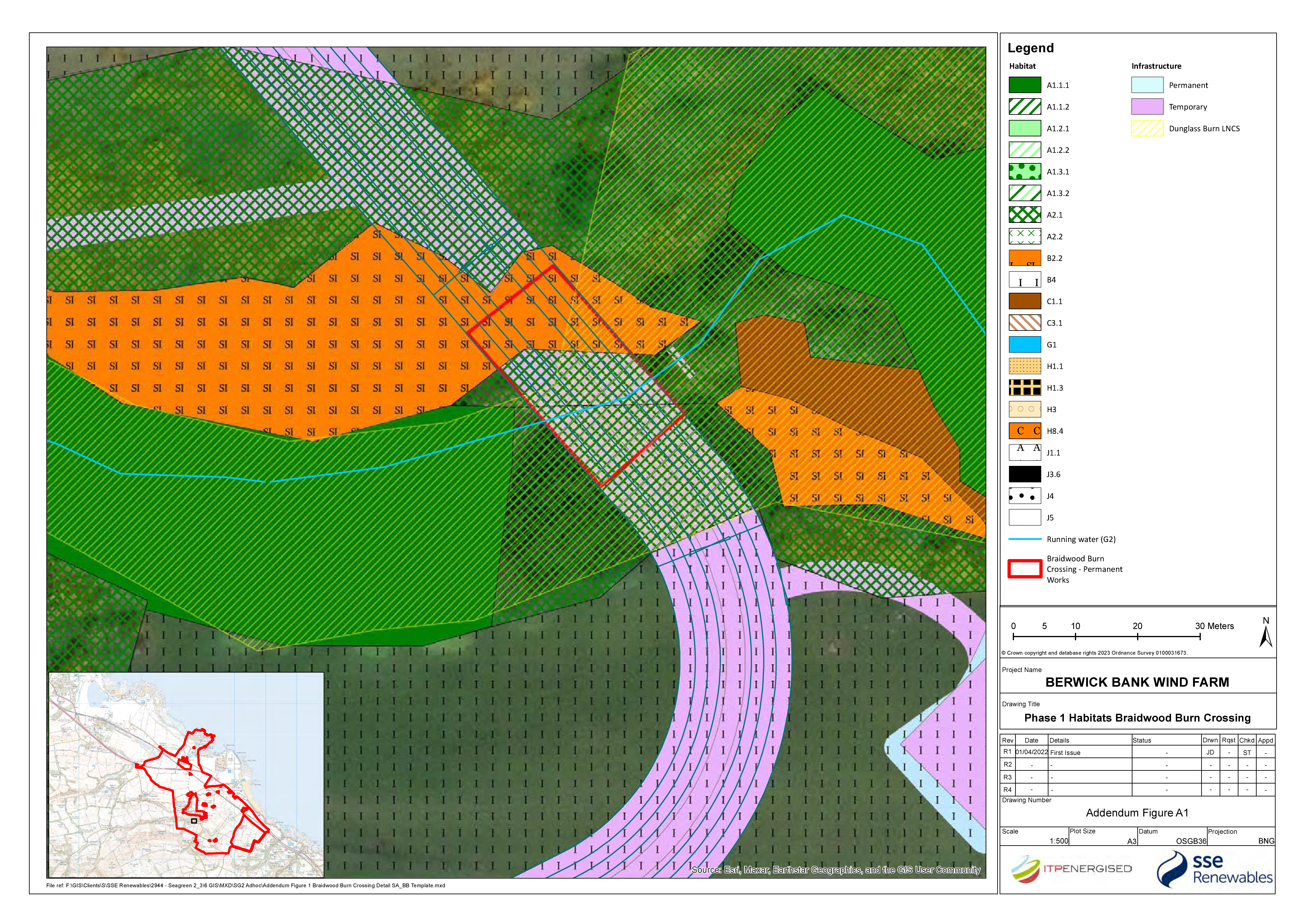
183. Part of the Dunglass Burn LNCS lies under the footprint of the Proposed Development as shown on Volume 2, Figure 7.2 and Figure A1. The site is designated for its broadleaved, semi-natural woodland habitat. Approximately c.11.19 ha of broadleaved semi-natural woodland extends along the Thornton Burn and Braidwood Burn corridor within the ecology study area and is comprised of native woodland which is semi-natural in its origins. Native woodlands are defined as those whose tree species arrived naturally in Scotland without any apparent direct human assistance. Most of native tree and shrub species colonised Scotland after the last Ice Age, which ended roughly 9,000 years ago. The cover of native woodlands in Scotland has been calculated to be 311,153 ha, of which 23,189 ha comprises lowland mixed deciduous woodland (Patterson et al., 2014), which is the category of the best fit with the broadleaved semi-natural woodland at this location.
184. This woodland is connected to two areas of AWI which lie within Thornton Glen SWT. These AWI stands are defined as Ancient (of semi-natural origin) 1a and 2b. This indicates that part of this woodland corridor has been continuously wooded since 1750 (1a) and 1860 (2b).
Construction Phase
Impact
185. Impacts on the Dunglass Burn LNCS will include direct loss of habitats within the footprint of temporary and permanent works to install the cable bridge over the Braidwood Burn, as well as temporary disturbance of vegetation adjacent to works areas.
Magnitude of Impact
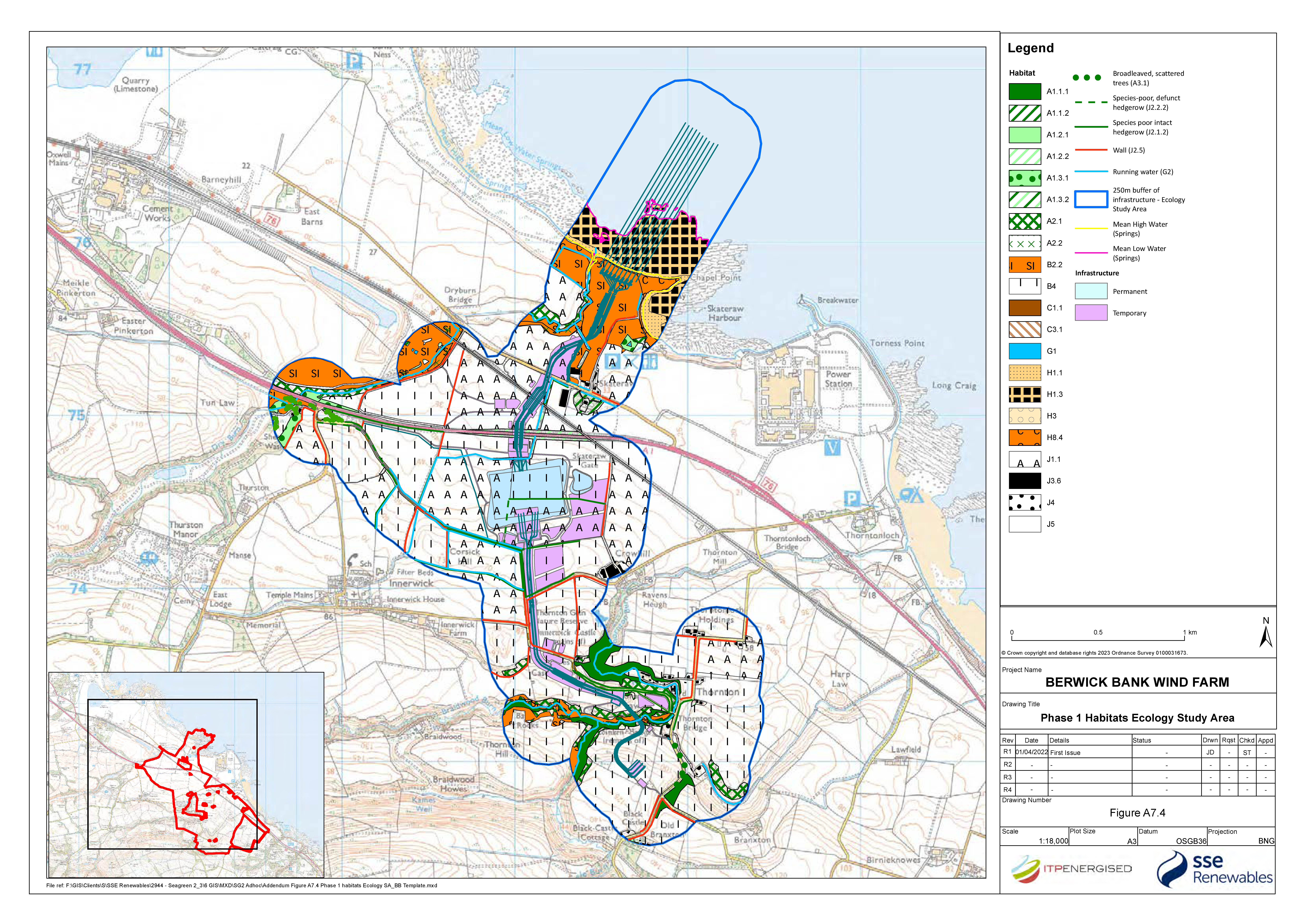
186. As shown on Volume 2, Figure 7.3, Figure A7.4 and Figure A1, a cable bridge crossing is proposed across the Braidwood Burn that passes through the Dunglass Burn LNCS for approximately 40 m. The footprint of the temporary and permanent works areas for the cable bridge within Dunglass LNCS is approximately 675 m2. The route has been microsited to minimise tree felling requirements and at the location of the cable bridge there is a natural gap in the broadleaved semi-natural woodland corridor. The proposed cable bridge is 40 m in length and 10 m in width therefore the footprint of the permanent works is estimated to be 400 m2. Habitat within the footprint of the permanent works is predominantly semi-improved grassland and dense scrub. The canopy is comprised of scattered semi-mature, multi-stem, ash trees with no mature tree specimens recorded within the footprint of the permanent or temporary works. Assuming the works could affect a zone of up to 15 m on either side of the footprint of works, up to 2,000 m2 of Dunglass Burn LNCS may be susceptible to temporary disturbance, including 140 m2 of broadleaved, semi-natural woodland, this is approximately 0.13% of the total extent of this habitat within the ecology study area.
187. The impact is predicted to be of local spatial extent, short-term duration, intermittent and medium reversibility. It is predicted that the impact will affect the receptor directly. The magnitude is therefore considered to be low.
Sensitivity of the Receptor
188. The Dunglass Burn LNCS is deemed to be of low vulnerability, medium recoverability and local value. The sensitivity of the receptor is therefore considered to be low.
Significance of the Effect
189. Given the above consideration of sensitivity and magnitude, the effect significance is considered to be negligible to minor adverse and not significant under the EIA Regulations.
Secondary Mitigation and Residual Effect
190. No secondary mitigation is considered necessary because the likely effect in the absence of secondary mitigation is not significant in EIA terms.
Thornton Glen SWT
Nature Conservation Value and Conservation Status
191. Thornton Glen SWT is approximately 6.50 ha in area and lies within 45 m of the footprint of the Proposed Development at its closest point as shown on Volume 2, Figure 7.3 The site is designated for its broadleaved, semi-natural woodland habitat. The SWT includes two areas of AWI. These AWI stands are defined as Ancient (of semi-natural origin) 1a and 2b. This indicates that this area of the woodland corridor has been continuously wooded since 1750 (1a) and 1860 (2b). The Thurston Burn Valley LNCS overlaps the SWT.
Construction Phase
Impact
192. As the Thornton Glen SWT lies over 15 m from the footprint of the Proposed Development no direct impacts are anticipated (e.g. habitat loss). The Proposed Development bisects the wider Thornton Burn and Braidwood Burn corridor at the location of a proposed cable bridge crossing which is to be installed over the Braidwood Burn (as shown on Volume 2, Figure 7.3, Figure A7.4 and Figure A1). These works may impact up to 2000 m2 of the riparian woodland corridor as discussed under Dunglass Burn LNCS. As these works have been micro-sited to pass through a natural gap in the woodland corridor it is anticipated that loss of tree canopy will be minimal and therefore the works are unlikely to result in the fragmentation of the woodland corridor.
Magnitude of Impact
193. The cable bridge crossing is proposed across Braidwood Burn that passes through an area of broadleaved, semi-natural woodland that connects to Thornton Glen SWT to the east. The footprint of the works areas for the cable bridge crossing within the Dunglass LNCS is approximately 675 m2 and the route has been micro-sited to minimise tree felling requirements. At the location of the cable bridge crossing there is a natural gap in woodland and the canopy is comprised of a scattered semi-mature, multi-stem, ash trees with no mature tree specimens recorded within the footprint of the works. The cable bridge crossing is 40 m in length and 10 m in width therefore the footprint of the permanent works is estimated to be 400 m2. The habitat under the permanent footprint of works is predominantly semi-improved neutral grassland and dense scrub. Assuming this could affect a zone of up to 15 m on either side of the footprint of works, up to 2,000 m2 of the Dunglass Burn LNCS may be susceptible to temporary disturbance, including 140 m2 of broadleaved, semi-natural woodland, this is approximately 0.13% of the total extent of this habitat within the ecology study area.
194. The impact is predicted to be of local spatial extent, short-term duration, intermittent and medium reversibility. It is predicted that the impact will affect the receptor indirectly. The magnitude is therefore considered to be low.
Sensitivity of the Receptor
195. The Thornton Glen SWT is deemed to be of medium vulnerability, low recoverability and local value. The sensitivity of the receptor is therefore, considered to be low.
Significance of the Effect
196. Given the above consideration of sensitivity and magnitude, the effect significance is considered to be negligible to minor adverse and not significant under the EIA Regulations.
Secondary Mitigation and Residual Effect
197. No secondary mitigation is considered necessary because the likely effect in the absence of secondary mitigation is not significant in EIA terms.
Dryburn Valley LNCS
Nature Conservation Value and Conservation Status
198. The Dryburn Valley LNCS lies under the footprint of the Proposed Development where a proposed cable bridge crosses the Skateraw Dean near the landfall, as shown on Volume 2, Figure 7.3 The features that this site is designated for include woodland listed within the Native Woodland Survey Scotland (NWSS), AWI woodland, and grassland. Notable species are ancient woodland flora. The site extends over an area of approximately 115 ha (or 1,150,000 m2), of which 1,650 m2 lies under the footprint of the Proposed Development (or 0.14 % of the total area).
199. The habitat present within the footprint of the Proposed Development is mixed plantation woodland, with sycamore, Scots pine, silver birch, beech, elder and ash recorded in the stand. This habitat type is not considered to be a designated feature of the LNCS.
Construction phase
Impact
200. Impacts on the woodland habitat will include a direct and permanent loss to the cable bridge crossing over the Skateraw Dean as well as temporary disturbance of vegetation adjacent to works areas.
Magnitude of Impact
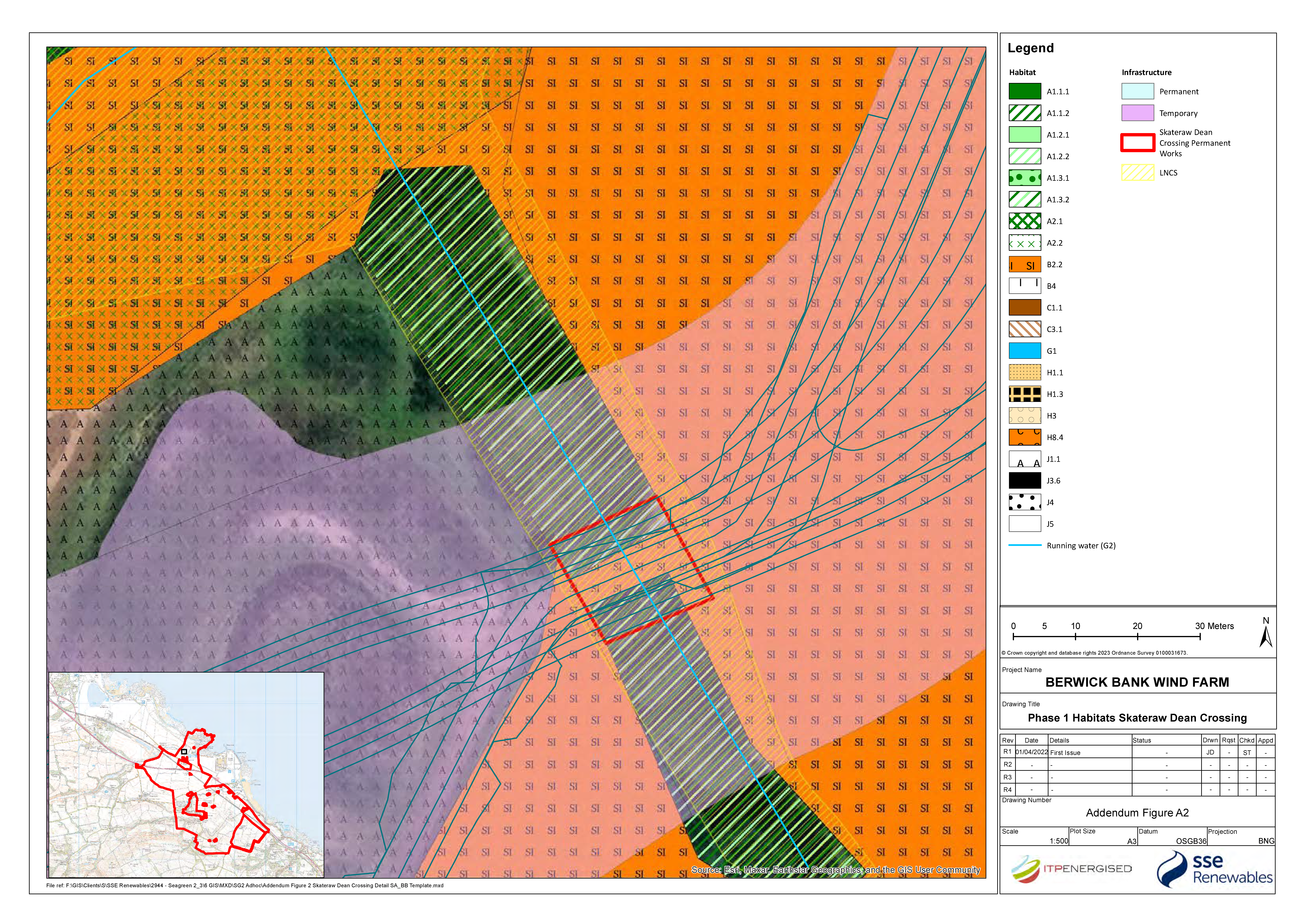
201. As shown on Figure A7.4 and Figure A2 a cable bridge crossing is proposed across Skateraw Dean. The footprint of the temporary and permanent works area for the cable bridge within the Dryburn Valley LNCS is approximately 25 m long, with an area of approximately 1,650 m2. The route will use an existing culvert which will be widened from 18 m to 30 m to accommodate the cables. This will require felling works either side of the existing culvert. Assuming this could affect a zone of up to 15 m on either side of the footprint of works, up to 2,600 m2 of the LNCS may be susceptible to temporary disturbance which represents 0.23% of the total area of the LNCS. The permanent footprint of the cable bridge crossing is 350 m2 which represents 0.03% of the total area of the LNCS.
202. The impact is predicted to be of local spatial extent, short-term duration, intermittent and medium reversibility. It is predicted that the impact will affect the receptor directly. The magnitude is therefore considered to be low.
Sensitivity of the Receptor
203. The Dryburn Valley LNCS is deemed to be of medium vulnerability, medium recoverability and local value. The sensitivity of the receptors is therefore, considered to be low.
Significance of the Effect
204. Given the above consideration of sensitivity and magnitude, the effect significance is considered to be negligible to minor adverse and not significant under the EIA Regulations.
Secondary Mitigation and Residual Effect
205. No secondary mitigation is considered necessary because the likely effect in the absence of secondary mitigation is not significant in EIA terms.
Dense and Scattered Scrub
Nature Conservation Value and Conservation Status
206. Dense and scattered scrub is a priority habitat on the East Lothian LBAP. Within the ecology study area, scrub vegetation is mostly dense and scattered gorse with some blackthorn and hawthorn recorded along the Braidwood Burn corridor. Approximately 16.38 ha of this habitat was recorded within the Proposed Development.
Construction phase
Impact
207. Impacts on the scrub habitat will include a direct loss where it lies under the footprint of temporary and permanent works as well as temporary disturbance of vegetation adjacent to works areas.
Magnitude of Impact
208. As shown on Figure A7.4 and Figure A1 scrub habitat lies under the footprint of a proposed temporary access road that runs parallel to the northern edge of Braidwood Burn woodland corridor and also under the temporary and permanent works area for the proposed cable bridge crossing over the Braidwood Burn. The total footprint for both works is 0.37 ha which represents 2.26 % of the total area of this habitat recorded within the ecology study area.
209. The impact is predicted to be of local spatial extent, short-term duration, intermittent and medium reversibility. It is predicted that the impact will affect the receptor directly. The magnitude is therefore considered to be low.
Sensitivity of the Receptor
210. The scrub habitat is deemed to be of low vulnerability, medium recoverability and local value. The sensitivity of the receptor is therefore considered to be low.
Significance of the Effect
211. Given the above consideration of sensitivity and magnitude, the effect significance is considered to be negligible to minor adverse and not significant under the EIA Regulations.
Secondary Mitigation and Residual Effect
212. No secondary mitigation is considered necessary because the likely effect in the absence of secondary mitigation is not significant in EIA terms.
Species-poor Hedgerow
Nature Conservation Value and Conservation Status
213. Hedgerow is listed under the East Lothian LBAP as a Priority Habitat. Approximately 7.36 km of species-poor hedgerow lies within the ecology study area.
Construction Phase
Impact
214. Impacts on species-poor hedgerows will include a direct and permanent loss where it lies under the footprint of the permanent works area as well as temporary disturbance of vegetation adjacent to works areas.
Magnitude of Impact
215. As shown on Figure A7.4 species-poor, intact and defunct hedgerow lies under both temporary and permanent work areas.
Temporary works area: A total of c.450 m of species-poor hedgerow lies under the footprint of temporary works areas and 140 m of species-poor intact hedgerow lies immediately adjacent to temporary works areas. Assuming works may impact a zone of up to 10 m either side of a hedgerow, approximately 600 m of hedgerow may be impacted by the temporary works.
Permanent works area: Approximately 460 m of species-poor hedgerow lies under the proposed onshore substation and adjacent access track. Assuming works may impact a zone of up to 10 m either side of a hedgerow, it is estimated that approximately 500 m of hedgerow may be impacted by the permanent works.
The total area impacted by temporary and permanent works (c. 1.1 km) is approximately 14.94% of the total area of hedgerow habitat recorded within the ecology study area.
216. The planting scheme for the Proposed Development will include replacement hedgerow planting within the temporary works areas, reducing the loss of hedgerows in the long-term to 6.79 % of the habitat recorded within the ecology study area.
217. The impact is predicted to be of local spatial extent, short-term duration, intermittent and medium reversibility. It is predicted that the impact will affect the receptor directly. The magnitude is therefore considered to be low.
Sensitivity of the Receptor
218. The species-poor hedgerow habitat is deemed to be of low vulnerability, medium recoverability and local value. The sensitivity of the receptor is therefore considered to be low.
Significance of the Effect
219. Given the above consideration of sensitivity and magnitude, the significance of effect is considered to be negligible to minor adverse and not significant under the EIA Regulations.
Secondary Mitigation and Residual Effect
220. No secondary mitigation is considered necessary because the likely effect in the absence of secondary mitigation is not significant in EIA terms.
Running Water Habitat
Nature Conservation Value and Conservation Status
221. The Thornton Burn, Thurston Mains, Ogle Burn, Braidwood Burn, Skateraw Dean, Dry Burn and an unnamed watercourse run through the ecology study area. Rivers are a Priority Habitat listed on the SBL and Rivers and Burns are a priority habitat under the East Lothian LBAP. In total approximately 10.48 km of watercourses run through the ecology study area. The Proposed Development crosses the Skateraw Dean at the north and the Braidwood Burn at the south, with cable crossings proposed at each location. It is proposed to temporarily divert, or overpump, the unnamed watercourse to allow for open cut trenching technique and burying of this section of cable. The remaining watercourses lie outwith the footprint of the Proposed Development, however the Braidwood Burn flows into the Thurston Mains and Thornton Burn and Skateraw Dean flows into Dry Burn therefore these watercourses may be indirectly impacted.
Construction phase
Impact
222. Impacts on the running water habitat will include temporary disturbance to the riparian habitat of Skateraw Dean and Braidwood Burn at the proposed cable bridge crossings. The unnamed watercourse will be temporarily diverted.
Magnitude of Impact
223. As shown on Figure A7.4, Figure A1 and Figure A2, cable bridge crossings are proposed across Skateraw Dean and Braidwood Burn. The width of the temporary works areas for the cable bridge crossing at Skateraw Dean is approximately 70 m and works are to include the widening of an existing culvert to cross the burn. At the Braidwood Burn, where the proposed cable bridge crossing is to be constructed, the width of the temporary works area is 45 m. Assuming the works may impact running water habitat 30 m either side of the footprint of works at each site, a combined length of up to 235 m of this habitat may be susceptible to temporary disturbance. This represents 2.24% of the undesignated running water habitat within the ecology study area.
224. The cable route is then proposed to be installed using open cut trenching underneath the unnamed watercourse to the south of the A1, directly north of the onshore substation, as shown on Figure A7.4. The width of the temporary works area at this location is 100 m and the footprint of the cabling is approximately 30 m. As a worst-case scenario it is assumed that 100 m of running water habitat may be impacted at this location, though it is likely to be less as the width of the cable footprint is approximately 30 m. This represents 0.95% of the undesignated running water habitat within the ecology study area.
225. The impact is predicted to be of local spatial extent, short-term duration, intermittent and high reversibility. It is predicted that the impact will affect the receptor indirectly (Skateraw Dean and Braid Burn) and directly (unnamed watercourse). The magnitude is therefore considered to be negligible.
Sensitivity of the Receptor
226. The running water habitat is deemed to be of medium vulnerability, medium recoverability and local value. The sensitivity of the receptors is therefore, considered to be low.
Significance of the Effect
227. Given the above consideration of sensitivity and magnitude, the effect significance is considered to be negligible to minor adverse and not significant under the EIA Regulations.
Secondary Mitigation and Residual Effect
228. No secondary mitigation is considered necessary because the likely effect in the absence of secondary mitigation is not significant in EIA terms.
3.3. Biodiversity Enhancement / Biodiversity Net Gain
229. Chapter 7: Ecology of the EIA Report includes details of Habitat Loss and Mitigation (Table 7.20) that are likely to result from the Proposed Development based on the current indicative level of design. Included within Chapter 6: Landscape and Visual Impact of the EIA Report are outline landscape mitigation measures focussed on the substation where the majority of permanent habitat loss would occur. The outline landscape mitigation which includes habitat creation is set out in Figure 6.12 of Chapter 6 of the EIA Report. In order to address consultee comments regarding the scale of the landscaping and enhancement opportunities the applicant has undertaken an Initial Biodiversity Net Gain Assessment based on the permanent habitat loss set out in the EIA and as amended through this Addendum (as noted in Section 3.2 and in Appendix 1). Based on a worst-case scenario this indicated that further habitat creation beyond that indicated in Figure 6.12 of Chapter 6 of the EIA Report would be required to deliver a net gain in biodiversity.
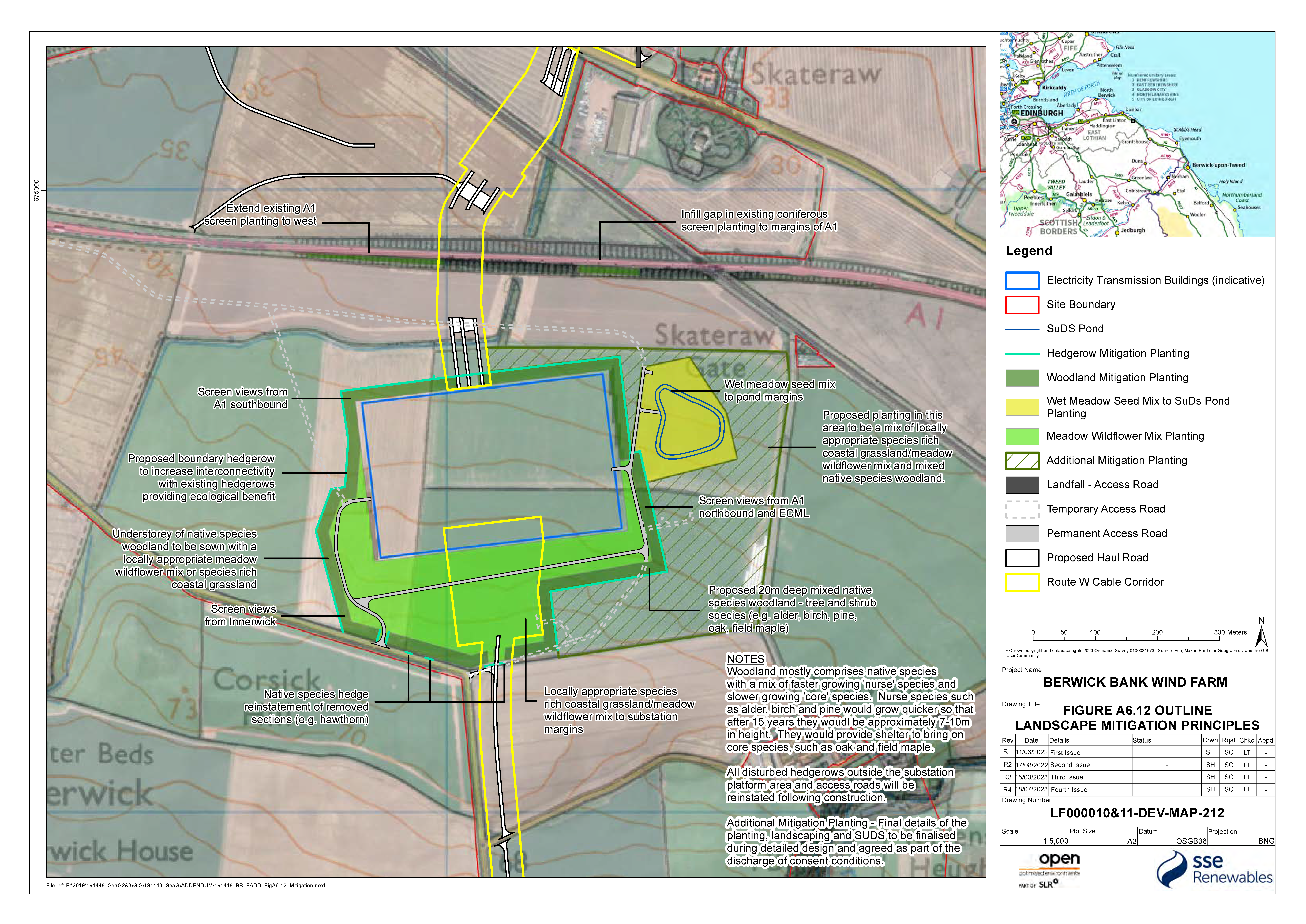
230. In order to provide greater confidence that the Proposed Development can deliver biodiversity mitigation and enhancement for habitats which are permanently lost to development or for areas of temporary loss which require time to reinstate the Applicant has clarified that further land would be available for habitat enhancement and has updated Figure 6.12 of the EIA Report (as noted in Section 3.4 of Appendix 1) and as appended as Figure A6.12.
231. The assessment, when considering the additional area available for potential habitat creation indicates that the use of around 60% of that additional available area for woodland and grassland creation would result in a 10% net gain in biodiversity value. For completeness, the assessment and a more detailed explanation of the assessment are appended to this Addendum as Appendix 1. Full details of habitat restoration (for areas of temporary loss) and of new habitat creation will be provided at a detailed design stage for agreement with ELC. The assessment will be updated on the basis of that detailed design in order to demonstrate a significant enhancement in biodiversity value in line with policy requirements.
3.4. Landscape Mitigation Plan
232. The Initial Biodiversity Net Gain Assessment undertaken for the project (refer to Appendix 1 of this Addendum) confirms that additional habitat enhancement is likely to be required in order to meet the policy expectations set out in NPF4. As noted above additional land subject to temporary works as part of the substation development has been identified that could be utilised for additional habitat enhancement that would expand upon and complement the existing outline enhancement and landscaping proposals set out in Figure 6.12 of the EIA Report. The revised Figure A6.12 provided with this Addendum supersedes Figure 6.12 of the EIA Report. The landscape and enhancement proposals remain at an outline stage and will be refined through further detailed design following the granting of planning permission in principle.
4. References
EastCoastGridServices Ltd (2022), Branxton Energy Storage Facility Planning Statement.
Crystal Rig Wind Farm (Phase IV) (2018), CRIV EIAR Appendix 7 – Ornithology.
Figures

APPENDIX 1: ONSHORE INITIAL BIODIVERSITY NET GAIN ASSESSMENT
Link to PDF Open ▸
APPENDIX A11.1: FLOOD RISK ASSESSMENT
Link to PDF Open ▸
[1] The term ‘local area’ is assumed to be comparable to the ‘local’ study area assessed within volume 1, chapter 13: Socio-economics of the Onshore EIA report.
[2] Habitat IEFs not brought forward for assessment detailed in Table 3.2.