

4. Conclusions
ITPEnergised (ITP) has been appointed by Berwick Bank Wind Farm Ltd (The Client) to provide support and input to the onshore component of the Environmental Impact Assessment Report (EIAR) submission to support a planning application for the onshore transmission works in connection with the Berwick Bank Offshore Windfarm.
In accordance with national planning policy and guidance, all potential sources of flooding to the site have been considered and no history of flooding at the site has been identified.
The flood risk assessment has been undertaken in consideration of the three main element of the Proposed Development; the landfall location, onshore cable route and onshore substation.
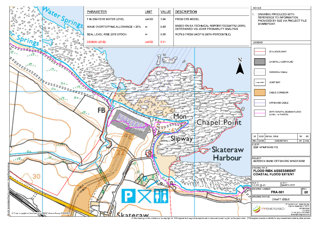
With respect to the landfall location, the assessment confirms that the site is overall at ‘no risk’ or ‘low risk’ of flooding from all sources with the exception of flooding from sea or tidal / coastal. Further assessment was undertaken to derive a design coastal flood level for the expected lifetime of the development of 35 years. The design flood level indicates that some of the landfall location infrastructure would be sited marginally seaward of the boundary. However, an assessment of the infrastructure undertaken by SSE-R concluded that cables and transition joints bays at the landfall location would be resilient to flooding once installed and remain operational. As such, the landfall infrastructure is considered to be at ‘low’ residual risk of flooding from sea or tidal / coastal sources.
With respect to the onshore cable route, the flood risk screening assessment confirms that the site is overall at ‘no risk’ or ‘low risk’ of flooding from all sources with the exception of flooding from fluvial sources in relation to two proposed watercourse crossing. Further assessment was undertaken for both crossings to assess any potential flood risk in greater detail. The assessment of the Innerwick Burn crossing has shown that any flood risk within the watercourse would be attributed to the existing upstream culvert given that it has a lower capacity than the proposed culvert to be extended to facilitate the cable crossing. The assessment of the Braidwood Burn crossing has provided two approaches to estimate the culvert’s ability to convey the predicted 1 in 200 year flow in the watercourse with constriction. Both methods undertaken provided conservative estimates of the culvert capacity and it has been shown that it is capable of conveying the design flow without restriction.
With respect to the onshore substation, the assessment confirms that the site is overall at ‘no risk’ or ‘low risk’ of flooding from all sources except ‘flooding from land’ which the screening assessment classified as ‘medium’ risk. The mitigation for this and full details are provided in the Drainage Strategy Report (EIAR Technical Appendix 11.2) which confirm that the onshore substation is considered at ‘low’ residual risk of flooding from land.
In accordance with SEPA guidance and NPF4, the Proposed Development is considered ‘Essential Infrastructure’ and is suitable within any flood risk zone, with further consideration required for developments in sparsely developed / undeveloped areas of ‘medium’ to ‘high’ risk, The screening assessment and technical assessments have shown that for all sources of flooding, the residual flood risk to the development and from the developed is considered to be ‘no’ to ‘low’ risk.
Taking all of the above into account it is considered there are no overriding impediments to the development being granted planning permission on the grounds of flood risk.
Drawings
Appendix A - Braidwood Burn ReFH2 Analysis
PDF document Open ▸
Appendix B - Braidwood Burn Crossing Design
PDF document Open ▸
Appendix C - Braidwood Burn Manning’s Equation Calculations
PDF document Open ▸

ITPEnergised is a leading, international consultancy offering renewable energy, natural resources, environmental, engineering, technical advisory and asset management services for clients with onshore and offshore projects.
Visit the ITPEnergised group offices in:
Bristol, London, Edinburgh, Glasgow, New York, Buenos Aries, Lisbon, Madrid, Delhi, Beijing, Canberra, Auckland
Sectors:
Onshore Renewables & Storage | Offshore Marine Renewables | Oil & Gas
Property & Urban Regeneration | Infrastructure | Industrial Manufacturing
![]()

[1] The Scottish Government (2023) National Planning Framework 4, February 2023
[2] British Geological Survey (2022) Natural Environment Research Council – online Geology of Britain Viewer, available at: http://mapapps.bgs.ac.uk/geologyofbritain/home.html
[3] UK Centre for Ecology & Hydrology (2022) Flood Estimation Handbook Web Service, Developed by Wallingford HydroSolutions
[4] Scottish Environment Protection Agency (2018): Flood Risk and Land Use Vulnerability Guidance
[5] Scottish Environment Protection Agency (2022): NFRA data explorer tool, available at: https://www.sepa.org.uk/data-visualisation/nfra2018/
[6] East Lothian Council (2018): Local Development Plan Strategic Flood Risk Assessment
[7] SEPA (2010) Engineering in the water environment: Good practice guide, River Crossings, 2nd Edition