4.5. Archaeological Assessment of Seabed Contacts Identified During Geophysical Survey
- This section reviews the archaeological potential of seabed contacts identified during the archaeological assessment of the site-specific geophysical surveys.
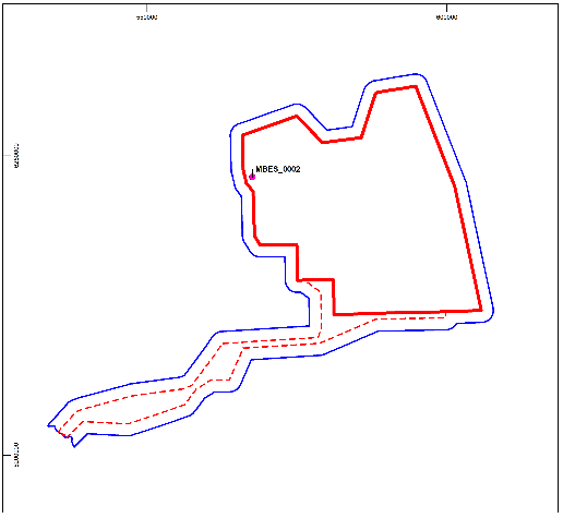
- A total of 244 anomalies of potential anthropogenic origin have been identified during the site-specific geophysical surveys within the Proposed Development site. Of these 197 were identified within Proposed Development array area. Forty-seven were identified within the Proposed Development export cable corridor (although, geophysical survey was not undertaken across the full extent of the Proposed Development export cable corridor).
- In all, 11 contacts were rated as being confirmed high archaeological potential within the Proposed Development site and 25 of unconfirmed medium archaeological potential. A total of 208 sites of low archaeological potential were recorded within the Proposed Development site. Anomalies of low potential have been assessed against all available evidence and as a result are considered unlikely to have any archaeological significance and are not discussed further in this report.
- The positions of the archaeological contacts of high and medium potential are shown in Figure 4.6 Open ▸ (and listed in annex C gazetteer of potential archaeological anomalies, annex D wreck sheets: high potential archaeological anomalies and annex E information sheets: medium potential archaeological anomalies). These are summarised in Table 4.3 Open ▸ below.
Table 4.3: Distribution of Anomalies by High and Medium Archaeological Potential
- In addition, a total of 106 magnetic anomalies with an intensity >100 nT with no correlating seabed contact were identified within the Proposed Development boundary. Of these, 37 lie within the Proposed Development array area, and 69 within the Proposed Development export cable corridor. These anomalies have the potential to represent material of potential archaeological significance and their positions are shown in Figure 4.6 Open ▸ and listed in annex F. A large proportion of these large magnetic anomalies form defined linear features the distribution of which lies within the Proposed Development export cable corridor and likely represent redundant cables, chain etc although there remains the potential for some of these anomalies to represent material of archaeological interest.
Figure 4.6: The Positions of Anomalies of High and Medium Potential within the Limits of the Proposed Development
4.5.1 Proposed Development Array Area
High potential anomalies
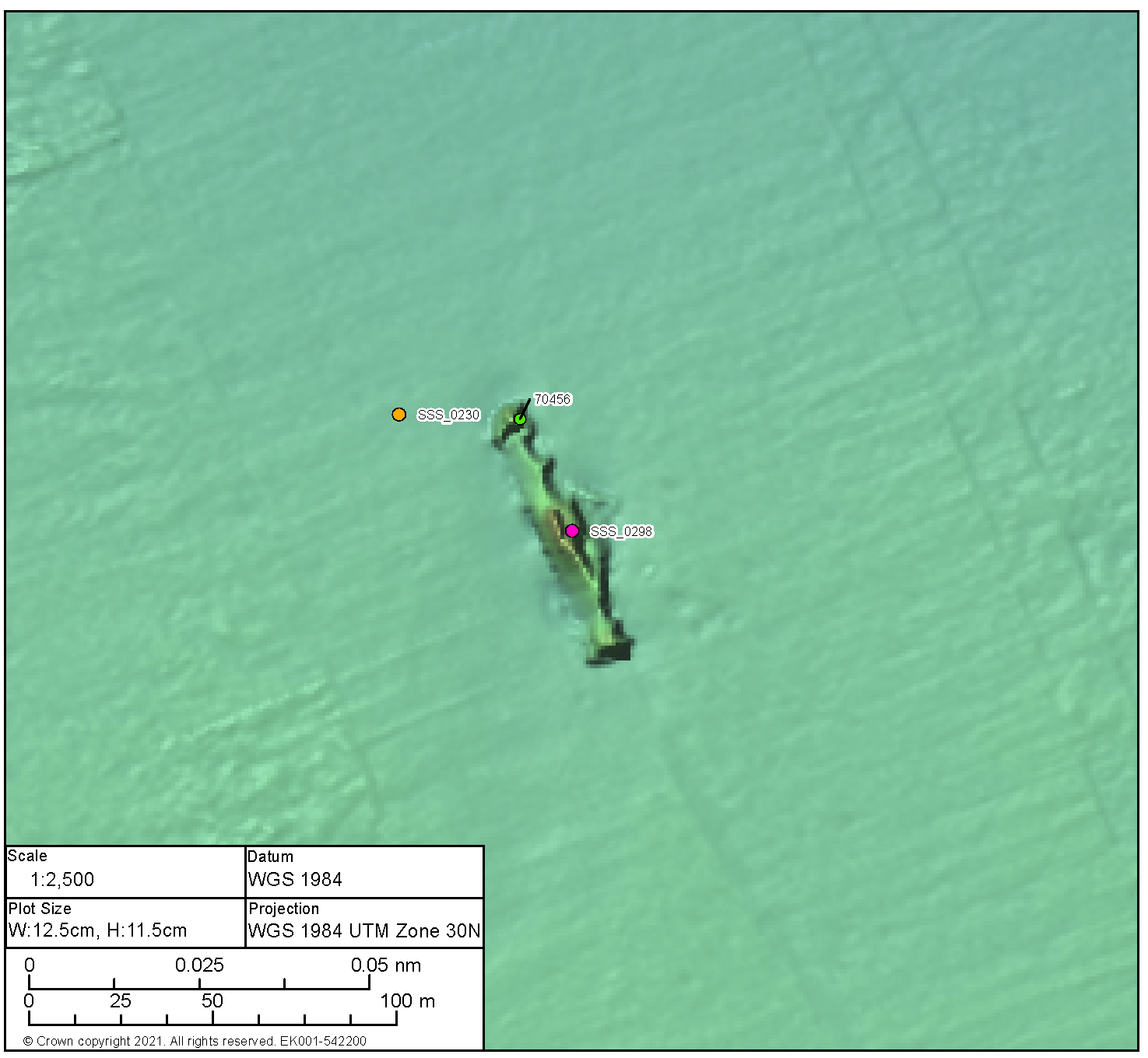
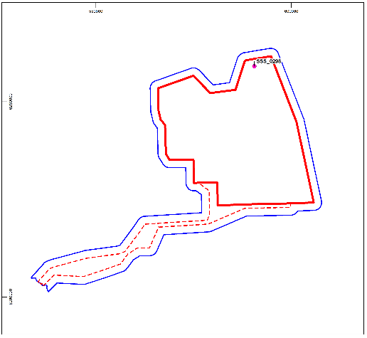
BBMB_SSS_2020_0298 (annexes C and D)
- BBMB_SSS_2020_0298 lies within and to the north of the Proposed Development array area and is the degraded, but coherent, remains of a wrecked vessel measuring 76.2 m x 19.7 m and with an associated magnetic anomaly of 59,127.2 nT. The wreck shows evidence of collapse along the length with debris extending to the seabed from the middle section. Debris is noted within the immediate vicinity of the wreck, including medium potential BBMB_SSS_2020_0298. The anomaly lies approximately 25.0 m west of the northern end of the wreck. The form is boulder like, however the proximity to the wreck could potentially indicate related debris. The form of the wreck, and the significant magnetic anomaly indicates metal construction.
- Extending from the wreck, 160 m to the south, is what appears to be an anchor and chain. It is unclear as whether the wreck and the anchor are related or whether is a later deposit.
- The wreck is recorded by the UKHO under record 70456 and was first identified in 2007, through survey, as an upright wreck measuring 77.0 m x 24.6 m and broken in three sections. Current data indicates that whilst the wreck is in poor condition any breaks in the structure are likely as a collapse rather than separation during the sinking event. The identity of the vessel is unknown.
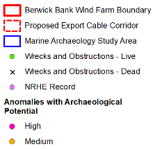
BBMB_SSS_2020_0212 (annexes C and D)
- BBMB_SSS_2020_0212 lies on the eastern boundary of the Proposed Development array area and is the coherent remains of a wrecked vessel measuring 91.6 m x 37.7 m with an associated magnetic anomaly of 1,056.7 nT. The wreck appears to be lying on its side and orientated north-east, south-west. The whole wreck shows evidence of collapse, but it is more prominent to the south-west. Large debris is visible adjacent to the main wreckage along the south-eastern edge. Two further pieces of debris likely related to the wreck are visible 50.0 m to the west (BBMB_SSS_2020_0254) and 60.0 m to the south (BBMB_SSS_2020_0255). Scour is visible around the wreck; however, it appears fairly localised.
- The wreck is recorded by the UKHO under record 70438 as the probable wreck of the Oswin, a Swedish steamship sunk in 1918. The wreck was located in 2007, through survey. Following a diving investigation in 2009 and the description provided by the divers the wreck was identified as probably that of the Oswin. Discrepancies between the current remains on the seabed and the as-built dimensions are likely a result of the collapse of the wreck.
- The potential wreck is not recorded by the UKHO but could potentially be one of the unverified wrecks recorded on the NRHE ( Figure 4.4 Open ▸ ).
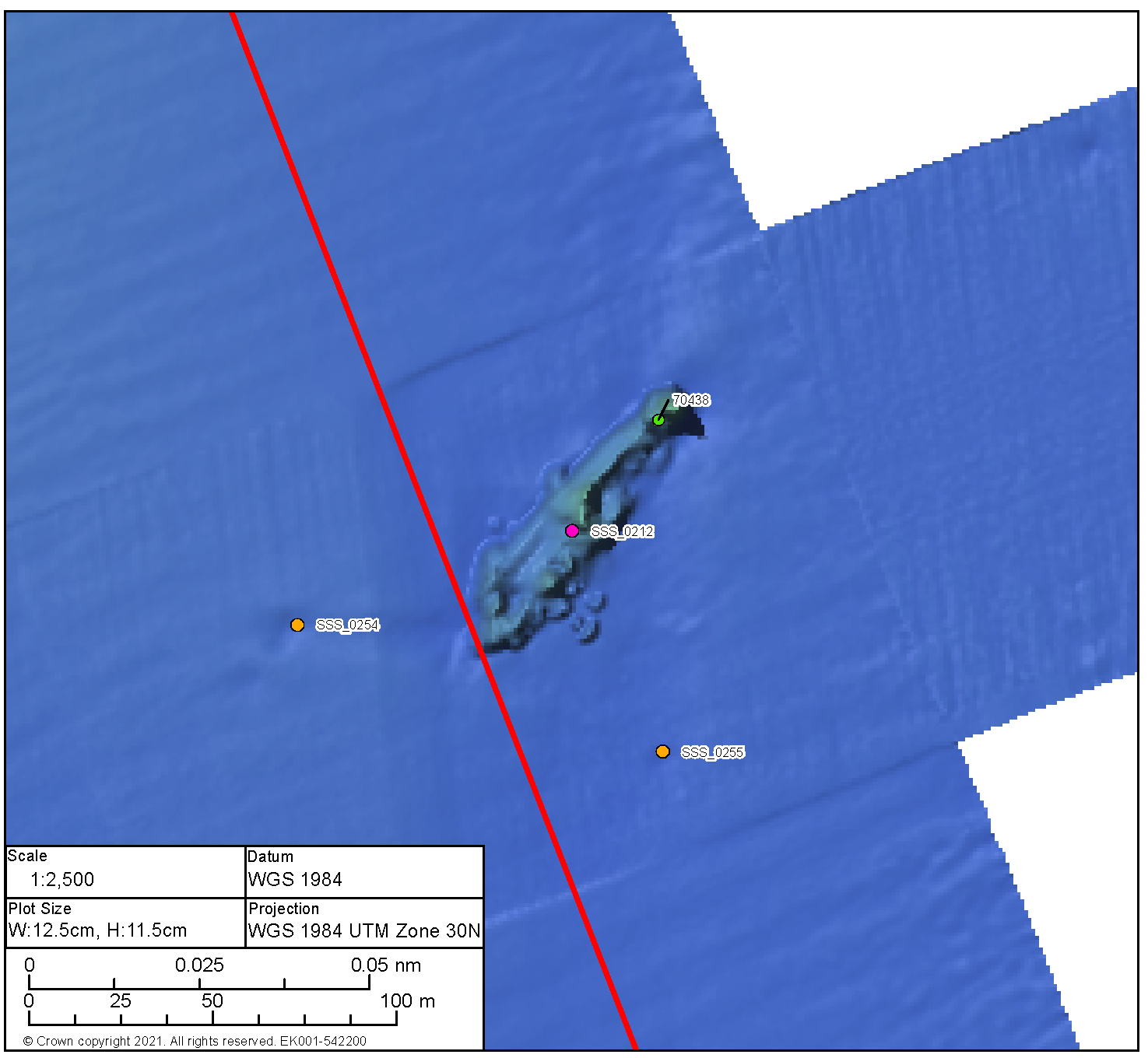
BBMB_MBES_2020_0005 (annexes C and D)
- BBMB_MBES_2020_0005 lies towards the south of the Proposed Development array area and is the remains of a broken-up vessel over an area 41.5 m x 12.3 m. The visible remains appear to show one section of the wreck lying east, west, potentially the bow, to the north and further visible debris to the south. Scour is evident to the south and east of the main section of wreckage. It is not possible to determine the construction type with the data available.
- The wreck is recorded by the UKHO under record 70460 and was first identified in 2007, through survey, as a highly degraded wreck measuring 70.5 m x 34.4 m. The differences in observed measurements are likely the result of sediment movement or continued degradation since 2007.
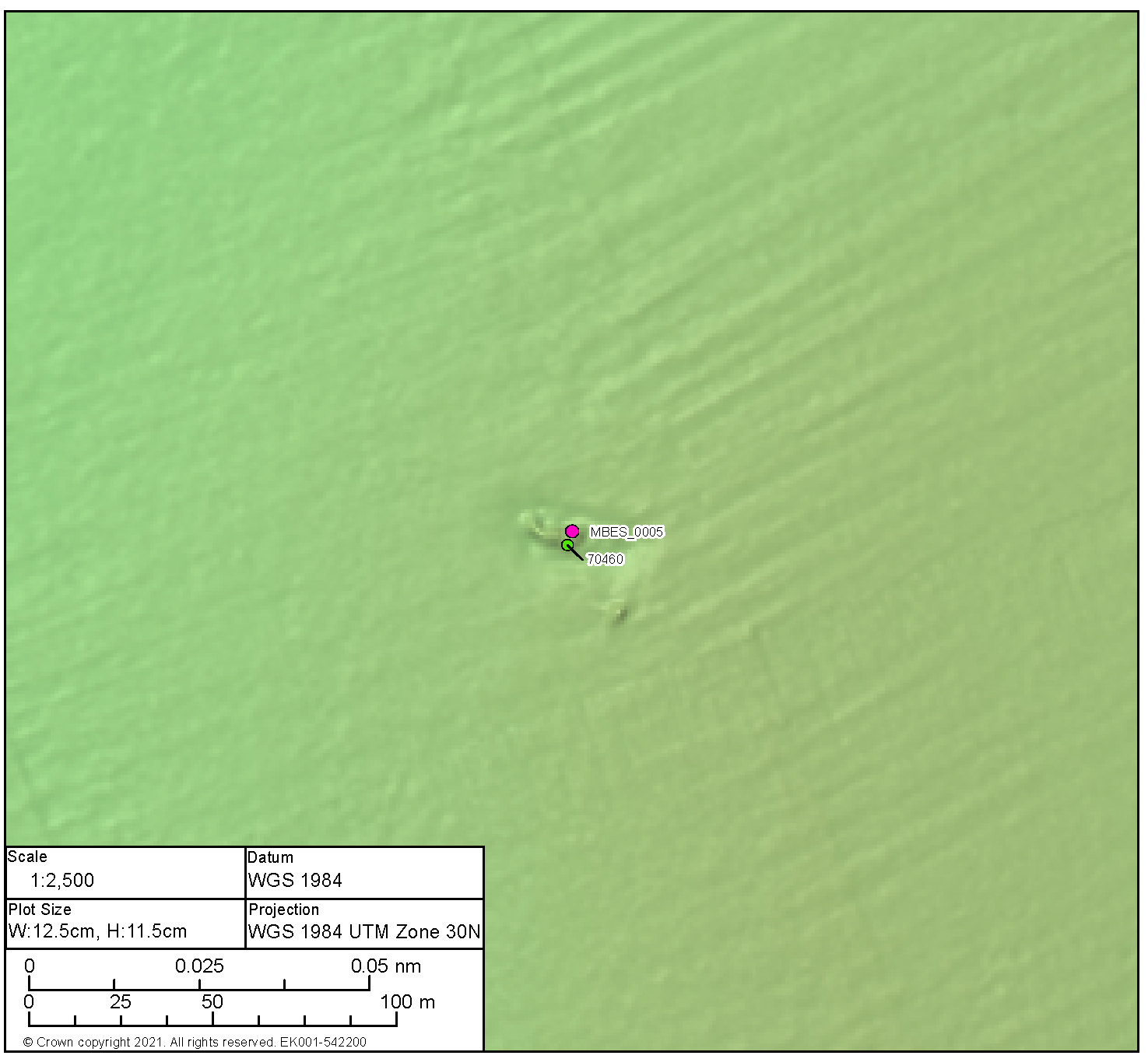
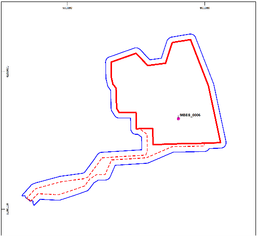
BBMB_MBES_2020_0006 (annexes C and D)
- BBMB_MBES_2020_0006 lies towards the south of the Proposed Development array area and is the remains of a wrecked vessel measuring 28.5 m x 8.5 m lying east, west, and with prominent scour to each end. The form of the wreck is coherent and likely of metal construction. There is little evidence of outlying debris.
- The wreck is recorded by the UKHO under record 70457 and was first identified in 2007, through survey, as an intact wreck measuring 46.2 m x 12.2 m with bows to the east and a list to port. There is a notable difference in dimensions, however there is no evidence of degradation or burial that would account for this, a likely assessment is that a previous build up seabed at each end of the wreck distorted the overall measurements in 2007.
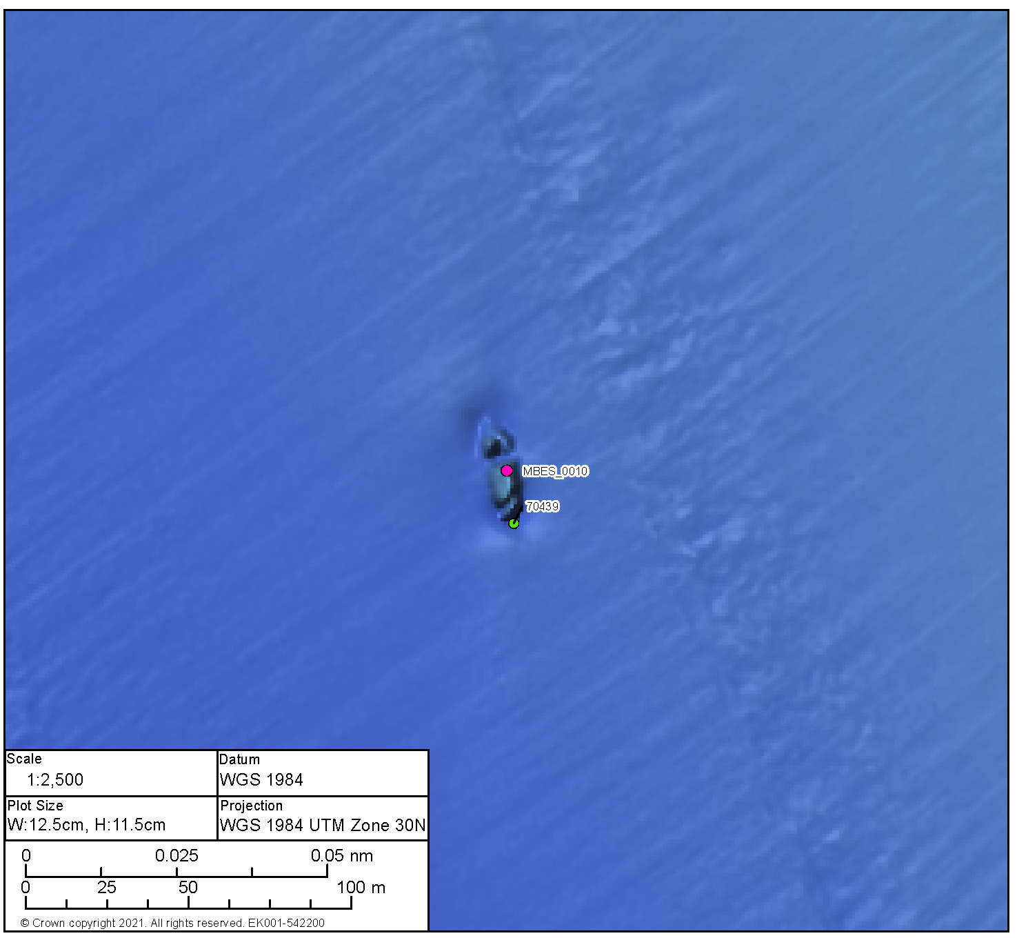
BBMB_MBES_2020_0010 (annexes C and D)
- BBMB_MBES_2020_0010 lies within the southern area of the Proposed Development array area and is the broken up remains of a wrecked vessel measuring 34.0 m x 10.7 m. The form of the wreck suggests steel construction with the bow to the north. The wreck is in two distinct, and separated, sections with further evidence of an addition break to towards the stern. The wreck sits within an area of scour, more prominent to the bow and the stern. There is little evidence of outlying debris.
- The wreck is recorded by the UKHO under record 70439 and was first identified in 2007, through survey, as an intact, upright wreck, 32.0 m x 9.0 m with the hold visible. Whilst the current dimensions correlate with those from 2007 the wreck can no longer be classed as intact.
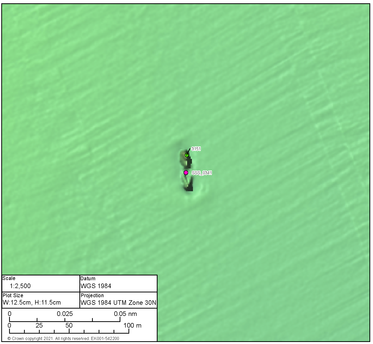
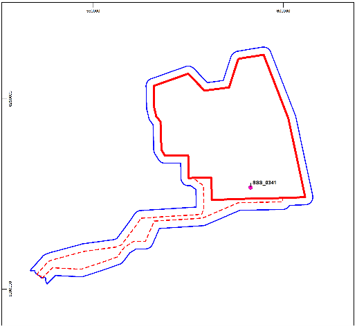
BBMB_SSS_2020_0341 (annexes C and D)
- BBMB_SSS_2020_0341 lies to the south-west of the Proposed Development array area and is the remains of a small vessel measuring 33.5 m x 7.6 m. The wreck is coherent in form, upright, and with the bow to the south. There is evidence of collapse amidships with the bow and stern remaining prominent. There is potentially small, localised debris towards the bow on the port side. Slight scour is evident around the wreck, more prominent towards the bow.
- The wreck is recorded by the UKHO under record 3151. The current position was established during survey works in 2007 and described as an upright, intact wreck measuring 45.2 m x 11.3 m. The wreck has been identified as possibly that of the Kitty, a British trawler sunk in 1917. The Kitty was built in 1898 by Earle’s Co Ltd in Hull as 32.0 m x 6.4 m which conform with the dimensions recorded in the data to which this report pertains.
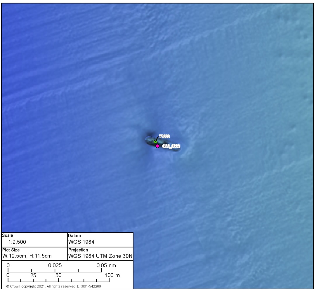
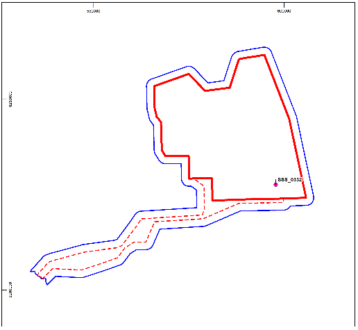
BBMB_SSS_2020_0332 (annexes C and D)
- BBMB_SSS_2020_0332 lies within the southern area of the Proposed Development array area and is the remains of a small vessel measuring 35.6 m x 8.6 m. The visible remains of the vessel potentially indicate the bow lies to the south-east. There is evidence of outlying debris within the immediate vicinity of the wreck. Scour is present, although conversely there appears to be an accretion of material to the bow and the stern.
- The wreck is recorded by the UKHO under record 71600 and was first identified in 2007, through survey, as a small, degraded, intact wreck measuring 34.0 m x 9.0 m. The identity of the wreck is unknown.
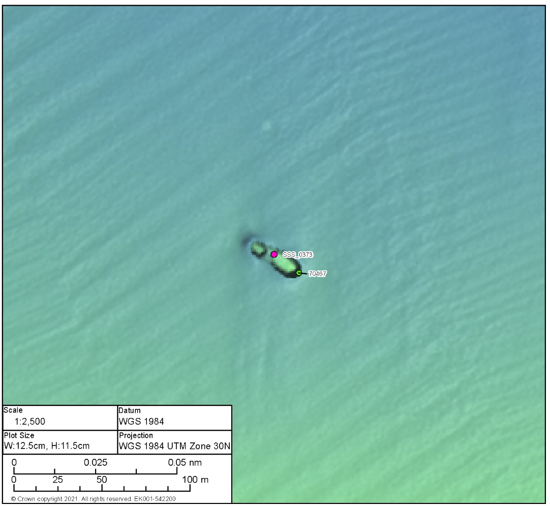
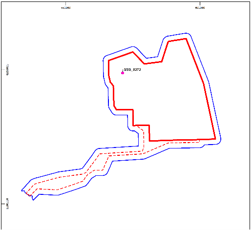
BBMB_SSS_2020_0373 (annexes C and D)
- BBMB_SSS_2020_0373 lies towards the northern area of the Proposed Development array area and is the coherent remains of a small, wrecked vessel measuring 33.1 m x 10.8 m with the bow potentially lying to the southeast. The vessel does not appear broken, however there is potential evidence of collapse towards the stern. Scour is evident around the wreck, most prominent to the stern but also extending north-east and south-west.
- The wreck is recorded by the UKHO under record 70467 and was first identified in 2007, through survey, as an upright, intact wreck measuring 41.3 m x 12.6 m. It is unclear where the difference in length originates as there is no evidence of collapsed or buried wreckage past the extents of that identified during this assessment. The identity of the wreck is unknown.
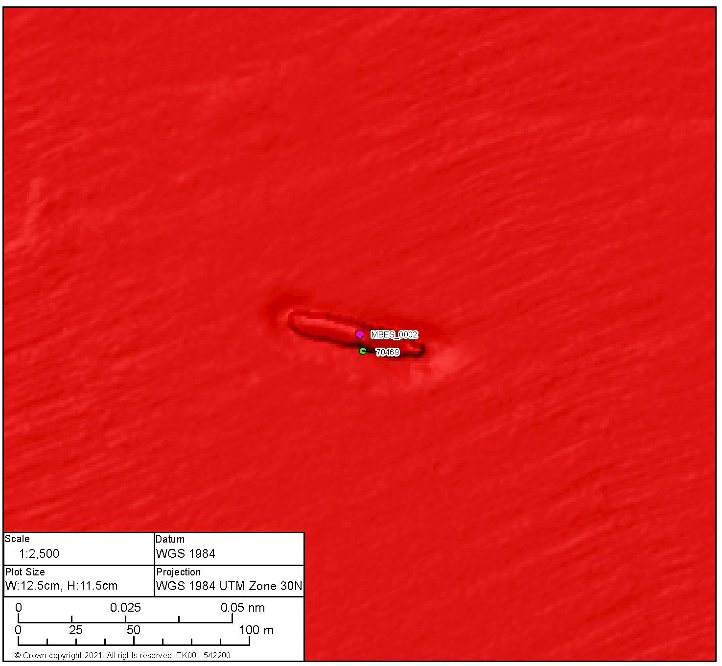
BBMB_MBES_2020_0002 (annexes C and D)
- BBMB_MBES_2020_0002 lies within the west area of the Proposed Development array area and is the prominent remains of a wrecked vessel measuring 60.5 m x 10.4 m and with a measurable height of 3.4 m. The wreck appears largely intact and is highly likely to be inverted, scour is evident along all sides although it is less prominent to the north. There is little evidence of any outlying debris. The form of the vessel, including size and current condition, indicates metal construction.
- The wreck is recorded by the UKHO under record 70469 and was first identified in 2007, through survey, as an intact wreck measuring 73.8 m x 14.0 m. No further information regarding origin or identity is available.
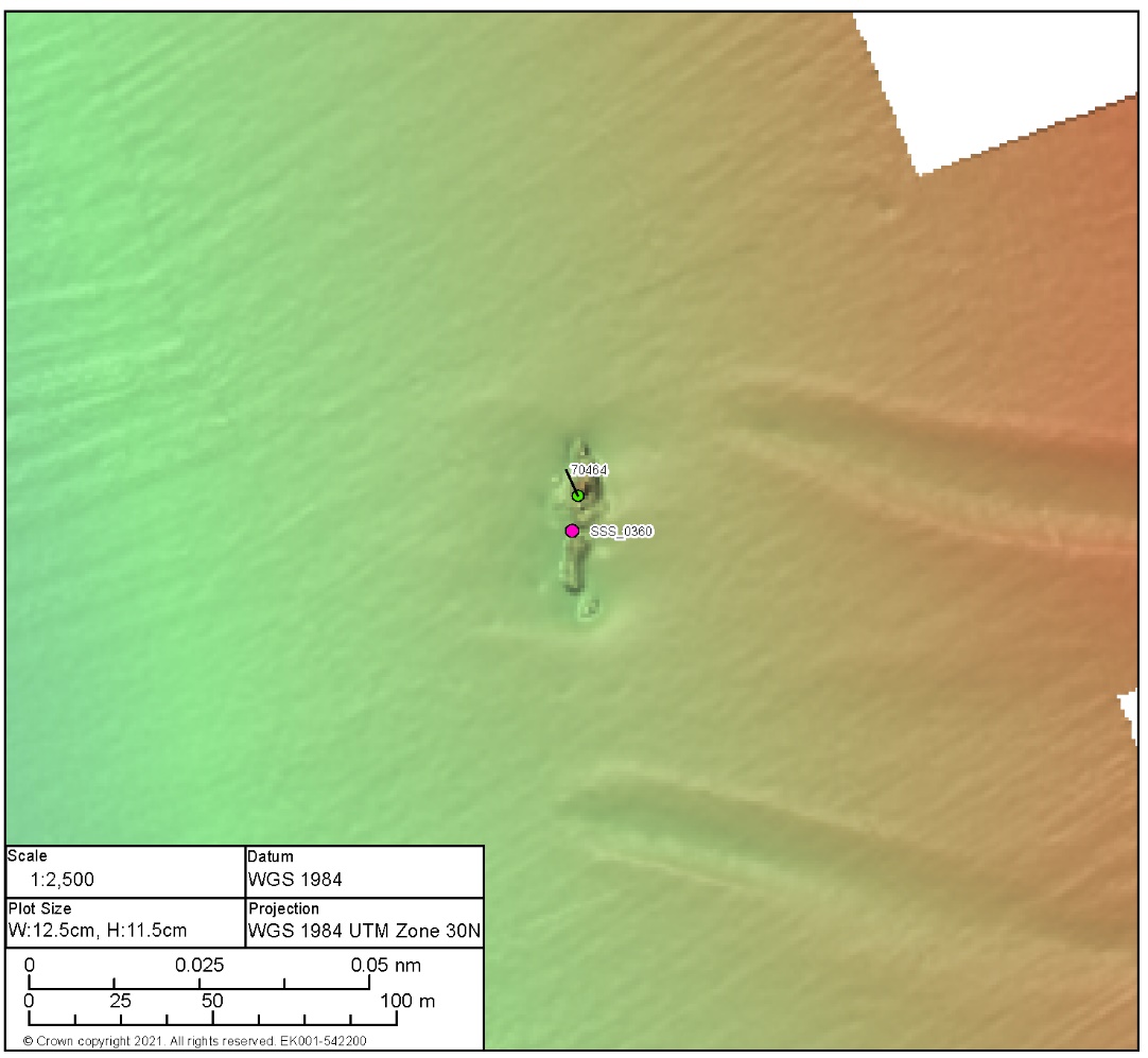
BBMB_SSS_2020_0360 (annexes C and D)
- BBMB_SSS_2020_0360 lies towards the centre of the Proposed Development array area and is the very broken up remains of a wrecked vessel measuring 48.1 m x 14.2 m and associated with a significant magnetic anomaly of 13,071.7 nT. The wreck is in two main sections orientated north, south with the most prominent remains to the south. A further smaller section lies to the south. Debris extents around the wreck but is largely confined to the footprint of the site. Scour is visible around the site and the form of the wreck, alongside the magnetic anomaly, indicates metal construction.
- The wreck is recorded by the UKHO under record 70464 and was first identified in 2007, through survey, as a highly degraded site measuring 44.8 m x 19.2 m. The identity of the wreck is unknown.
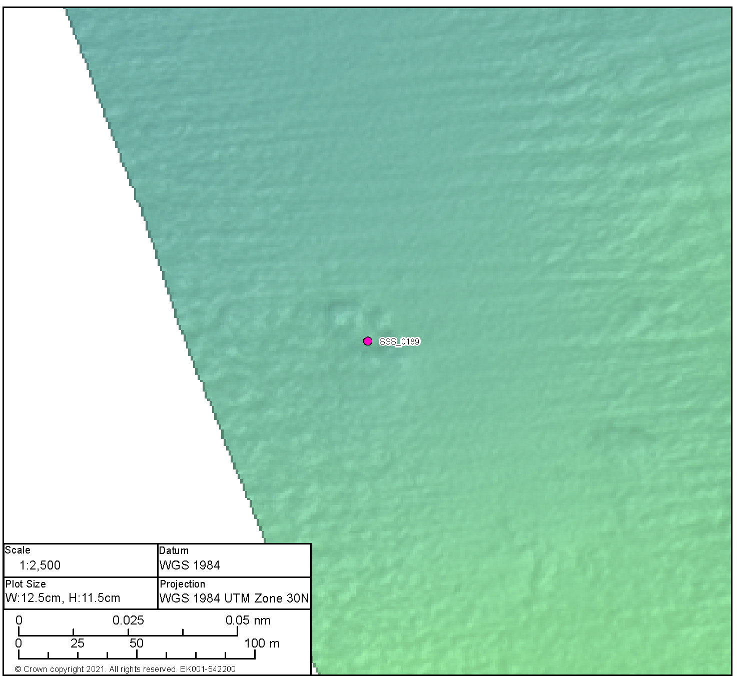
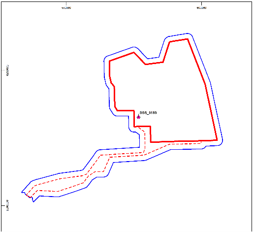
BBMB_SSS_2020_0189 (annexes C and D)
- BBMB_SSS_2020_0189 lies on the south-western boundary of the Proposed Development array area and is the potential remains of a wrecked vessel measuring 36.2 m x 19.1 m. The form of the anomaly is vessel like in shape and comprises a distinct area of potential anthropogenic debris characterised by multiple features many of which are linear in form. The wreck is low lying with a maximum height of 1.0 m and very broken up, scour is evident around all sides, however it is more prominent to the north.
- The wreck is not recorded by the UKHO but could potentially be one of the unverified wrecks recorded on the NRHE ( Figure 4.4 Open ▸ ).
Medium potential anomalies
- The distribution of medium potential anomalies across the Proposed Development array area is shown in Figure 4.6 Open ▸ with further details in annex E. Unlike the high potential anomalies which comprise clearly recognisable anthropogenic objects (e.g. wrecks) medium potential anomalies represent objects or sites of likely anthropogenic origin that require further investigation in order to fully clarify their nature and establish their archaeological potential.
- There are 20 medium potential anomalies within the Proposed Development array area. Further investigation will be required in order to establish the identity and archaeological significance of these once the final design of Proposed Development is finalised and the potential for direct interaction with these anomalies confirmed.
Magnetic anomalies
- A total of 37 large (>100 nT) magnetic anomalies with no obvious corresponding contact are located within the Proposed Development array area. Their locations are shown in Figure 4.7 Open ▸ with further details in annex F.
Recorded wrecks/Obstructions not identified by geophysical survey
- A total of six UKHO records from within the Proposed Development array area were not identified by geophysical survey (UKHO 3155 Benbow, UKHO 3153 Rudolph, UKHO 3154, UKHO 3157, UKHO 3159, UKHO 3173 Desabla). All of these records relate to wrecks now considered Dead by the UKHO. The marking of a record as Dead means it is no longer detected by repeated surveys and is therefore considered not to exist. It can therefore be assumed that the wreck no longer exists at the given position. Where records relate to a reported sinking there remains the possibility that the wreck lies within the wider area as with the Desabla which was identified as lying on its port side in 2010 during a diver survey but was not identified during the recent survey suggesting it could be currently buried by sediment.
- In addition, it is possible that some of the unverified wrecks recorded by the NRHE could relate to the Medium Potential Anomalies or the Magnetic Anomalies identified during the survey ( Figure 4.8 Open ▸ ).
4.5.2. Proposed Development Export Cable Corridor
High potential anomalies
- There are no anomalies of high potential identified within the Proposed Development export cable corridor (although the survey did not cover the full extent of the Proposed Development export cable corridor).
Medium potential anomalies
- The distribution of medium potential anomalies across the Proposed Development export cable corridor is shown in Figure 4.6 Open ▸ with further details in annex E. Unlike the high potential anomalies which comprise clearly recognisable anthropogenic objects (e.g. wrecks) medium potential anomalies represent objects or sites of likely anthropogenic origin that require further investigation in order to fully clarify their nature and establish their archaeological potential.
- There are five medium potential anomalies within the Proposed Development export cable corridor. Further investigation will be required to establish the identity and archaeological significance of these once the final design of the Proposed Development is finalised and the potential for any direct interaction with these anomalies confirmed.
Magnetic anomalies
- A total of 69 large (>100 nT) magnetic anomalies with no obvious corresponding contact are located within the Proposed Development export cable corridor. The locations of these are shown in Figure 4.7 Open ▸ with further details in annex F.
Recorded wrecks/Obstructions not identified by geophysical survey
- An obstruction recorded as a rock in the UKHO records was not identified by geophysical survey (UKHO 3149) within the Proposed Development export cable corridor. This record is considered Dead by the UKHO. The marking of a record as Dead means it is no longer detected by repeated surveys and is therefore considered not to exist. It can therefore be assumed that the obstruction no longer exists at the given position.
- In addition, eight wrecks recorded on the UKHO and located within the Proposed Development export cable corridor that were not identified by geophysical survey. As such, the positions of these wrecks have not as yet been verified and must be assumed at this stage (UKHO 2873, UKHO 2884; UKHO 2890; UKHO 2892; UKHO2904 Craddock; UKHO 3101; UKHO 63948 UKHO 2875 Sharon Vale). In addition, it is possible that some of the unverified wrecks recorded by the NRHE relate to the Medium Potential Anomalies or the Magnetic Anomalies identified during the survey ( Figure 4.8 Open ▸ ).
Figure 4.7 Magnetic Anomalies with an Intensity >100 nT within the Limits of the Proposed Development
Figure 4.8: Positions of Known and Potential Archaeological Anomalies and as yet Unverified Recorded Wrecks
5. Conclusions
5.1. Submerged Prehistoric Archaeological Potential
- The marine archaeology study area was submerged during the late glacial/early Holocene and prior to this it was covered in a succession of ice sheets. During periods of glaciation the marine archaeology study area would have been uninhabitable but during inter-glacial periods there is a potential for periglacial occupation at times when the seabed would have formed dry land. The zones of highest potential for the survival of archaeological material are likely to be those on the edges of channels and floodplains, where old ground surfaces and organic remains are most likely to survive. These deposits often lie beneath relatively thin layers of seafloor sediment and may be vulnerable to exposure.
- However, based on the available evidence whilst potential palaeo-landscape features have been recorded within the Proposed Development boundary including palaeo-channels, incised valleys and relict glacial lakes, the proglacial environments in which they are likely to have been formed are not likely to have been attractive locations for human habitation. In other areas such features would have formed foci for human activity following climatic amelioration, however, sea level rises are likely to have submerged these features within the site relatively rapidly further demonstrating the limited archaeological potential of the area.
- Consequently, it is considered unlikely that evidence of in situ Palaeolithic and Mesolithic activity will be found within the Proposed Development array area due to the effects of repeated glaciations, marine transgressions and associated fluvial activity. There is however some paleoenvironmental potential within the Aberdeen Ground Formation. Within the Proposed Development export cable corridor there is some potential for late Palaeolithic/Mesolithic deposits in the near shore area although due to the effects of erosion redeposited material is more likely than in situ evidence. In addition, the localised presence of peat buried in the Quaternary deposits could suggest a good palaeo-environmental potential and where these sediments are present there is a good potential for organic preservation of remains such as fish traps, associated with prehistoric exploitation of the coastal margins. Future archaeological assessment of the results of pre-construction geotechnical investigations within the Proposed Development site will provide further information on the presence or absence of peat and the palaeo-environmental and archaeological potential of this area.
5.2. Maritime Archaeological Potential
- The North Sea has been identified as a region with historically high levels of shipping and military aviation activity and vessel/aircraft loss. The survival of ship and aircraft wrecks depends on a range of factors, including the age and construction material of any wreck.
- No designated wrecks are recorded within the marine archaeology study area, although one known wreck (U 12) lies within the west of the marine archaeology study area. The wreck is considered a war grave and so will fall within the protection of the Protection of Military Remains Act.
- A total of eleven wrecks have been recorded by the site-specific geophysical survey within the Proposed Development array area, one of which is known; Kitty. Of the remaining ten wrecks, nine are also recorded as UKHO data. The remaining wrecks may represent one of the wrecks recorded on the NRHE as potentially lying within the Proposed Development array area (although none of the positions have been verified). In addition, six wrecks included within the UKHO data were not identified during the survey and their positions have been recorded as ‘Dead’ (although one wreck recorded as ‘dead’ (Desabla) was recorded during a diver survey in 2010).
- No wrecks were recorded within the Proposed Development export cable corridor during the site-specific geophysical survey (although the survey did not cover the full extent of the Proposed Development export cable corridor). There are eight wrecks recorded on the UKHO located within the Proposed Development export cable corridor that fall outside the GSA and so their positions have not as yet been verified and so must be assumed at this stage (UKHO 2873, UKHO 2884; UKHO 2890; UKHO 2892; UKHO2904 Cradock; UKHO 3101; UKHO 63948, UKHO 2875 Sharon Vale).
- In addition, 25 unconfirmed anomalies identified as being of medium archaeological potential and 106 large magnetic anomalies of archaeological potential were recorded within the Proposed Development site. Some of these anomalies may be associated with wrecks recorded on the UKHO, NRHE, Scottish Borders or East Lothian HER that have no known position, or they could represent anomalies of as yet unknown archaeological interest.
- With respect to shipwrecks, there is a scarcity of charted wrecks pre-dating the 19th century in or near the marine archaeology study area. The known shipwrecks are iron and steel vessels dating from the 19th and 20th centuries. As has been made clear above, this over-representation of more recent wrecks in the record of known and charted sites is the result not only of the nature of their construction, but also the method in which wrecks were recorded in the past.
- The preponderance of iron and steel wrecks in the record probably masks the presence of earlier shipwrecks, which are of potentially greater archaeological interest. Compared to iron and steel wrecks, wooden shipwrecks tend to be older, smaller and to have carried less ferrous material. They also tend to break up more quickly than iron and steel wrecks and are thus more likely to be scattered, dispersed and have a generally lower physical profile on the seabed. Consequently, they are less likely to be located by geophysical survey.
- These earlier wrecks are potentially the most archaeologically important and there will be an on-going recognition of the potential to encounter currently unknown or unrecorded shipwrecks, and mechanisms put in place to ensure the prompt reporting and avoidance of undue damage to any such discoveries.
- There is therefore a generally moderate to good potential for unexpected remains to be discovered within the marine archaeology study area.
6. References
ABP Marine Environmental Research Ltd (2010). Waterlands: Developing Management Indicators for Submerged Palaeoenvironmental Landscapes
Ballin, T.B., Saville, A., Tipping, R., Ward, T. (2010). An Upper Palaeolithic flint and chert assemblage from Howburn Farm, South Lanarkshire, Scotland in Oxford Journal of Archaeology vol 29
Baird, B. (1993). Shipwrecks of the Firth, including wrecks from Berwick on Tweed to Stonehaven.
Bell (2007). Prehistoric Coastal Communities: the archaeology of Western Brigitain 6000-3000 B.C. CBA Research Report 149.
Bédoyère, G. de la, (2001). Aviation Archaeology in Britain.
Bradley, R, Bradley, R.J, Fulford, M.G. and Tyson, H.J. (1997). The archaeological resource: A regional review in Fulford, M. Champion, T. and Long, A. (eds.) England’s Coastal Heritage: A survey for English Heritage and the RCHME English Heritage.
Breen, C, and Forsythe, W. (2004). Boats and shipwrecks of Ireland.
British Geological Survey (BGS) (1994). United Kingdom Offshore Regional Report: The geology of the central North Sea
Brooks, A.J., Bradley, S., Edwards, R.J., Goodwayn N (2011). The Palaeogeography of Northwest Europe during the last 20,000 years in Journal of Maps 7.
Chapman, H P, and Chapman, P R. (2005) Seascapes and Landscapes — the Siting of the Ferriby Boat Finds in the Context of Prehistoric Pilotage in The International Journal of Nautical Archaeology Vol. 34, No. 1 April 2005.
Clark, P. (2002) The Dover Bronze Age Boat in Context: Society and water transport in prehistoric Europe.
Clark, P., Hughes, A.L.C., Greenwood, S.L., Jordan, C., Sejrup, H.P. (2012) Pattern and timing of retreat of the last British-Irish Ice Sheet.
Cunliffe, B. (2001) Facing the Ocean. The Atlantic and its Peoples, 8000 B.C.-A.D. 1500.
Cunliffe, B. (1990) ‘Hengistbury Head: a late prehistoric haven’, in McGrail S. (ed.), Maritime Celts, Frisians and Saxons in CBA Research Report No. 71:27-31.
Delgado, J. (1997) Encyclopaedia of underwater and maritime archaeology.
Dunkley, M. (2016) Ships and Boats: Prehistory to 1840 Historic England.
Dunwell and Ralston (2008) Archaeology and Early History of Angus.
Ellmers, D. (1996) Earliest Ships.
Fenwick, V. and Gale, A. (1998) Historic Shipwrecks: Discovered, Protected and Investigated.
Ferguson D 1991 Shipwrecks of North East Scotland 1444 – 1990.
Firth, A. (2014) East Coast War Channels in the First and Second World War A report for English Heritage Fjordr unpublished report Ref: 16131 English Heritage Ref: 6586.
Flemming, N (2004) The scope of Strategic Environmental Assessment of North Sea Area SEA5 in regard to prehistoric archaeological remains.
Friel, I. (2003) Maritime History of Great Britain.
Fugro Consultants 2019 SSE Seagreen 2 and 3 and ECR Seagreen Windfarm Zone Geophysical Survey.
Fugro Consultants 2020a Seagreen 2 and 3 Windfarm Zones Geophysical Survey Operations Report – Fugro Frontier and Fugro Pioneer
Fugro Consultants 2020b Seagreen 2 and 3 Windfarm Zones Geophysical Survey Operations Report – Fugro Mercator and Fugro Seeker
Headland Archaeology (2011) Maritime Cultural Heritage Baseline Technical Report Seagreen Energy Phase 1.
Holmes R 1977 Quaternary Deposits of the central North Sea 5 in Report of the Institute of the Geological Sciences Vol77/14
Hutchinson, J. (1997) Medieval Ships and Shipping.
Johnstone, P. (1980) The Sea-craft of Prehistory.
Lambert, A., (2001), Steam, Steel and Shellfire The Steam Warship 1815 – 1905.
Larn, R. and Larn, B. (1998) Shipwreck Index of the British Isles: Volume 4 – Scotland, Lloyd’s Register of Shipping, London.
Lillie, M. (2005) Deconstructing reconstruction: The Bronze Age sewn plank boats from North Ferriby, River Humber, England, UK and their context in Journal of Wetland Archaeology 5:97-109.
Lourandos, H. (1997) Continent of Hunter-Gatherers: New Perspectives in Australian Prehistory.
Lyall, G. (1971) The War in the Air.
Marean, C. W., Bar-Matthews, M., Bernatchez, J., Fisher, E., Goldberg, P., Herries, A.I.R., Jacobs, Z., Jerardino, A., Karkanas, P., Minichillo, T., Nilssen, P. J., Thompson, E., Watts, I. and Williams, H. M. (2007) Early human use of marine resources and pigment in South Africa during the Middle Pleistocene in Nature 449, 905-909.
Marsden, P. (1994) Ships of the Port of London: First to Eleventh Centuries A.D.
McGrail, S. (1981) The Brigg 'Raft' and her Prehistoric environment, British Archaeological Reports, British Series 89.
McGrail, S. (1987) Ancient Boats in North-West Europe.
McGrail, S. (2004) Boats of the World: From the Stone Age to Medieval Times.
McGrail, S, and Parry, S.J. (1991) A flat-bottomed boat from the R. Usk at Tredunnoc, Gwent, Wales, in R Reinders and K Paul (eds.) Carvel Construction Techniques, Oxbow Monograph 12, 161-169.
Milne, G. (1990) Maritime traffic between the Rhine and Roman Britain: a preliminary note, in McGrail, S. (ed.), Maritime Celts, Frisians and Saxons in CBA Research Report No 71, pp 82-85.
Mowat, R J C. 1996. The Logboats of Scotland. Oxbow Monograph 68. Oxbow Books. Oxford.
MSDS Marine (2021) Archaeological Review of Geophysical and Hydrographic Data
Nayling, N. and McGrail, S. (2004) Barland's Farm Romano-celtic Boat.
Needham, S. (2009) Encompassing the Sea: ‘Maritories’ and Bronze Age maritime interactions in Clark, P (ed.) Bronze Age connections Cultural Contact in Prehistoric Europe.
Owen O 1999 The Sea Road: A Viking Voyage Through Scotland.
Scottish Executive (2007) Scottish Marine SEA: Environmental Report Section C Chapter C11 Marine and Coastal Historic Environment
SSER (2022a). Berwick Bank Wind Farm Onshore EIA Report.
Strachan D (2004) A Late Bronze Age logboat from the Tay estuary at Carpow, Perth and Kinross in Tayside Fife Archaeology Journal vol 10.
Stringer (2006) Homo Brittanicus: The Incredible Story of Human Life in Britain.
Stringer, C., Finlayson, J. C., Barton, R. N. E., Fernandez-Jalvo, Y., Caceres, I., Sabin, R.C., Rhodes, E. J., Currant, A. P., Rodriguez-Vidal, J., Giles-Pacheco, F. and Riquelme-Cantal, J. (2008) Neanderthal exploitation of marine mammals in Gibraltar in Proceedings of the National Academy of Sciences 105(38), 14319–14324.
Stoker M, Skinner A, Fyfe J and Long D (1983) Palaeomagnetic evidence for early Pleistocene in the central and northern North Sea in Nature 304.
Stoker M, Golledge, N, Phillips E, Wilkinson I and Akhurst M 2008 Lateglacial-Holocene shoreface progradation offshore eastern Scotland: a response to climatic and coastal hydrographic change in Boreas Vol38
The Crown Estate (2014). Protocol for Archaeological Discoveries: Offshore Renewables Projects.Published by Wessex Archaeology, Salisbury, on behalf of The Crown Estate
Thomson M (1978) IGS Studies of the geology of the Firth of Forth and its approaches Report of the Institute of Geological Sciences 77/17.
Van de Noort, R. (2003) An ancient seascape: the social context of seafaring in the early Bronze Age in World Archaeology 35 (3), 404-414.
Van de Noort, R. (2011) North Sea Archaeologies: A Maritime Biography, 10,000 B.C. to A.D. 1500.
Van de Noort, R, Middleton, R, Foxon, A. and Bayliss, A. (1999) The ‘Kilnsea-boat’ and some implications from the discovery of England’s oldest plank boat remains, in Antiquity 73:131-135.
Wessex Archaeology (2004) Artefacts from the Sea. Aggregate Levy Sustainability Fund Marine Aggregates and the Historic Environment Report.
Wessex Archaeology (2007) UKCS Offshore Oil and Gas and Wind Energy Strategic Environmental Assessment.
Wessex Archaeology (2008) Aircraft Crash Sites at Sea: A Scoping Study. Archaeological Desk-based Assessment.
Whitaker IG (1998) Off Scotland A comprehensive Record of Marine and Aviation Loss in Scottish Waters
Wilkinson, T.J. and Murphy, P.L. (1995) The Archaeology of the Essex Coast, Volume I: The Hullbridge Survey, Essex County Council Archaeology Section in East Anglian Archaeology Report No. 71.
Woodman, R. (1997) The History of the Ship: The Comprehensive Story of Seafaring from the Earliest Times to the Present Day.
7. Confidential Annexes
7.1. Confidential Annex A: Gazetteer of UKHO Data within the Marine Archaeology Study Area
Table 7.2: Gazetteer of UKHO Data within the Proposed Development Array Area and 2 km Buffer
7.2. Confidential Annex B: Gazetteer or NHRE Data within the Marine Archaeology Study Area
Table 7.3: Gazetteer of NHRE Data within the Marine Archaeology Study Area
7.3. Confidential Annex C: Gazetteer of Potential Archaeological Anomalies
7.4. Confidential Annex D: Wreck Sheets: High Potential Archaeological Anomalies within Limits of Proposed Development
High Potential Contact BBMB_SSS_2020_0298 | ||||||
|---|---|---|---|---|---|---|
Position coordinates
| 590519.6 E, 6259051.7 N | Area | Proposed Development array area |
| ||
Archaeological potential | High | |||||
Geophysical survey dimensions and notes | Dimensions: 76.2 m x 19.7 m x 3.8 m high Contact is associated with magnetic anomaly 56,127.2 nT and medium potential BBMB_sss_2020_0298 UKHO 70456 | |||||
Build | Type | Unknown | ||||
Construction | Form and evidence of significant magnetic anomaly suggest metal construction | |||||
Dimensions | Unknown | |||||
Shipyard | Unknown | |||||
Loss | Cause | Unknown | ||||
Extent of survival | Degraded but coherent remains of a wrecked vessel. The wreck shows evidence of collapse along the length with debris extending to the seabed from mid -section. Debris is noted in immediate vicinity. | |||||
|
Legend | |||||
Position coordinates
| 601282.4 E 6245056.7 N | Area | Proposed Development array area |
| ||
Archaeological potential | High | |||||
Geophysical survey dimensions and notes | Dimensions: 91.6 m x 37.7 m x 6.1 m high Contact is associated with magnetic anomaly 1,056.7 and large debris adjacent 50 m to the west ( BBMB_SSS_2020_0254) and 60 m to the south (BBMB_SSS_2020_0255) | |||||
Build | Type | Likely to be the Swedish Steamship Oswin (recorded by UKHO 70438) | ||||
Construction | Form and evidence of significant magnetic anomaly suggest metal construction | |||||
Dimensions | Unknown | |||||
Shipyard | Built in Whitby in 1890 | |||||
Loss | Cause | Cargo ship on voyage to Goteburg carrying coal when it was sunk by a German submarine in 1918. No lives were lost; | ||||
Extent of survival | Coherent remains of a wrecked vessel. The wreck appears to be lying on its side and orientated north-east, south-west. The whole wreck shows evidence of collapse but it is more prominent to the south-west. Scour is visible around the wreck; however, it appears fairly localised. | |||||
|
Legend | |||||

Position coordinates
| 588871.4 E 6232899.6 N | Area | Proposed Development array area |
| ||
Archaeological potential | High | |||||
Geophysical survey dimensions and notes | Dimensions: 41.5 m x 12.3 m x 0.8 m high Contact is not associated with any magnetic anomaly UKHO Ref 70460 | |||||
Build | Type | Unknown | ||||
Construction | Unknown | |||||
Dimensions | Unknown | |||||
Shipyard | Unknown | |||||
Loss | Cause | Unknown | ||||
Extent of survival | The visible remains appear to show one section of the wreck lying east, west, potentially the bow, to the north and further visible debris to the south. Scour is evident to the south and east of the main section of wreckage. It is not possible to determine the construction type with the data available. The wreck was first identified in 2007, through survey, as a highly degraded wreck measuring 70.5 m x 34.4 m. The differences in observed measurements are likely the result of sediment movement or continued degradation since 2007 | |||||
|
Legend | |||||

High Potential Contact BBMB_MBES_2020_0006 | ||||||
|---|---|---|---|---|---|---|
Position coordinates
| 590388.3 E 6232872.8 N | Area | Proposed Development array area |
| ||
Archaeological potential | High | |||||
Geophysical survey dimensions and notes | Dimensions: 28.5 m x 8.5 m x 3.0 m high Contact is not associated with any magnetic anomaly UKHO Ref 70457 | |||||
Build | Type | Unknown | ||||
Construction | Likely of metal construction | |||||
Dimensions | Unknown | |||||
Shipyard | Unknown | |||||
Loss | Cause | Unknown | ||||
Extent of survival | The wreck is lying east, west, and with prominent scour to each end. The form of the wreck is coherent and there is little evidence of outlying debris. The wreck was first identified in 2007, through survey, as an intact wreck measuring 46.2 m x 12.2 m with bows to the east and a list to port. There is a notable difference in dimensions, however there is no evidence of degradation or burial that would account for this, | |||||
|
Legend | |||||
High Potential Contact BBMB_MBES_2020_0010 | ||||||
|---|---|---|---|---|---|---|
Position coordinates
| 597610.4 E 6231315.9 N | Area | Proposed Development array area |
| ||
Archaeological potential | High | |||||
Geophysical survey dimensions and notes | Dimensions: 34.0 m x 10.7 m x 2.7 m high Contact is not associated with any magnetic anomaly UKHO ref 70439 | |||||
Build | Type | Unknown | ||||
Construction | Likely of steel construction | |||||
Dimensions | Unknown | |||||
Shipyard | Unknown | |||||
Loss | Cause | Unknown | ||||
Extent of survival | Broken up remains of a wrecked vessel with the bow to the north. The wreck is in two distinct, and separated, sections with further evidence of an addition break to towards the stern. The wreck sits within an area of scour, more prominent to the bow and the stern. There is little evidence of outlying debris. First identified in 2007, through survey, as an intact, upright wreck, with the hold visible. Whilst the current dimensions correlate with those from 2007 the wreck can no longer be classed as intact. | |||||
|
Legend | |||||

High Potential Contact BBMB_SSS_2020_0341 | ||||||
|---|---|---|---|---|---|---|
Position coordinates
| 591366.5 E 6226686.0 N | Area | Proposed Development array area |
| ||
Archaeological potential | High | |||||
Geophysical survey dimensions and notes | Dimensions: 33.5 m x 7.6 m x 3.3 m high Contact is not associated with a magnetic anomaly UKHO ref 3151 | |||||
Build | Type | Likely to be the Fishing Trawler Kitty recorded by UKHO | ||||
Construction | Likely of metal construction | |||||
Dimensions | 32.0 m x 6.4 m | |||||
Shipyard | Built by Earle’s Co, Hull in 1898 | |||||
Loss | Cause | En-route to Peterhead and captured by submarine and sunk by explosives in 1917. No lives were lost | ||||
Extent of survival | The wreck is coherent in form, upright, and with the bow to the south. There is evidence of collapse amidships with the bow and stern remaining prominent. There is potentially small, localised debris towards the bow on the port side. Slight scour is evident around the wreck, more prominent towards the bow. | |||||
|
Legend | |||||
High Potential Contact BBMB_SSS_2020_0332 | ||||||
|---|---|---|---|---|---|---|
Position coordinates
| 597770.1 E 6227609.8 N | Area | Proposed Development array area |
| ||
Archaeological potential | High | |||||
Geophysical survey dimensions and notes | Dimensions: 35.6 m x 8.6 m x 2.3 m high Contact is not associated with a magnetic anomaly UKHO ref 71600 | |||||
Build | Type | Unknown | ||||
Construction | Unknown | |||||
Dimensions | Unknown | |||||
Shipyard | Unknown | |||||
Loss | Cause | Unknown | ||||
Extent of survival | The visible remains of the vessel potentially indicate the bow lies to the south-east. There is evidence of outlying debris within the immediate vicinity of the wreck. Scour is present, although conversely there appears to be an accretion of material to the bow and the stern. | |||||
|
Legend | |||||
High Potential Contact BBMB_SSS_2020_0373 | ||||||
|---|---|---|---|---|---|---|
Position coordinates
| 571145.9 E 6248792.9 N | Area | Proposed Development array area |
| ||
Archaeological potential | High | |||||
Geophysical survey dimensions and notes | Dimensions: 33.1 m x 10.8 m x 8.7 m high Contact is not associated with a magnetic anomaly UKHO ref 70467 | |||||
Build | Type | Unknown | ||||
Construction | Unknown | |||||
Dimensions | Unknown | |||||
Shipyard | Unknown | |||||
Loss | Cause | Unknown | ||||
Extent of survival | Coherent remains of a small, wrecked vessel with the bow potentially lying to the south, east. The vessel does not appear broken, however there is potential evidence of collapse towards the stern. Scour is evident around the wreck, most prominent to the stern but also extending north-east and south-west. The wreck was first identified in 2007, through survey, as an upright, intact wreck measuring 41.3 m x 12.6 m. It is unclear where the difference in length originates as there is no evidence of collapsed or buried wreckage past the extents of that identified during this assessment. | |||||
|
Legend | |||||
High Potential Contact BBMB_MBES_2020_0002 | ||||||
|---|---|---|---|---|---|---|
Position coordinates
| 567551.6 E 6246444.9 N | Area | Proposed Development array area |
| ||
Archaeological potential | High | |||||
Geophysical survey dimensions and notes | Dimensions: 60.5 m x 10.4 m x 3.4 m high Contact is not associated with a magnetic anomaly UKHO ref 70469 | |||||
Build | Type | Unknown | ||||
Construction | Likely of metal construction | |||||
Dimensions | Unknown | |||||
Shipyard | Unknown | |||||
Loss | Cause | Unknown | ||||
Extent of survival | Prominent remains of a wrecked vessel. The wreck appears largely intact and is highly likely to be inverted, scour is evident along all sides although it is less prominent to the north. There is little evidence of any outlying debris. | |||||
|
Legend | |||||
High Potential Contact BBMB_SSS_2020_0360 | ||||||
|---|---|---|---|---|---|---|
Position coordinates
| 577863.1 E 6245712.0 N | Area | Proposed Development array area |
| ||
Archaeological potential | High | |||||
Geophysical survey dimensions and notes | Dimensions: 48.1 m x 14.2 m x 2.3 m high Contact is associated with a significant magnetic anomaly of 13,071.7 nT UKHO ref 70464 | |||||
Build | Type | Unknown | ||||
Construction | Likely of metal construction | |||||
Dimensions | Unknown | |||||
Shipyard | Unknown | |||||
Loss | Cause | Unknown | ||||
Extent of survival | Very broken up remains of a wrecked vessel. The wreck is in two main sections orientated north, south with the most prominent remains to the south. A further smaller section lies to the south. Debris extents around the wreck but is largely confined to the footprint of the site. Scour is visible around the site. | |||||
|
Legend | |||||

High Potential Contact BBMB_SSS_2020_0189 | ||||||
|---|---|---|---|---|---|---|
Position coordinates
| 574835.5 E 6230067.7 N | Area | Proposed Development array area |
| ||
Archaeological potential | High | |||||
Geophysical survey dimensions and notes | Dimensions: 36.2 m x 19.1 m x 1.0 m high Contact is not associated with a magnetic anomaly nor has it been recorded on the UKHO | |||||
Build | Type | Unknown | ||||
Construction | Of metal construction | |||||
Dimensions | Unknown | |||||
Shipyard | Unknown | |||||
Loss | Cause | Unknown | ||||
Extent of survival | Potential remains of a wrecked vessel. The form of the anomaly is vessel like in shape and comprises a distinct area of potential with anthropogenic debris characterised by multiple features many of which are linear in form. The wreck is low lying and very broken up, scour is evident around all sides, however it is more prominent to the north. | |||||
|
Legend | |||||