

1. MPA Assessment
1.1. Introduction
- Berwick Bank Wind Farm Limited (BBWFL) is a wholly owned subsidiary of SSE Renewables Limited and will hereafter be referred to as ‘the Applicant’.
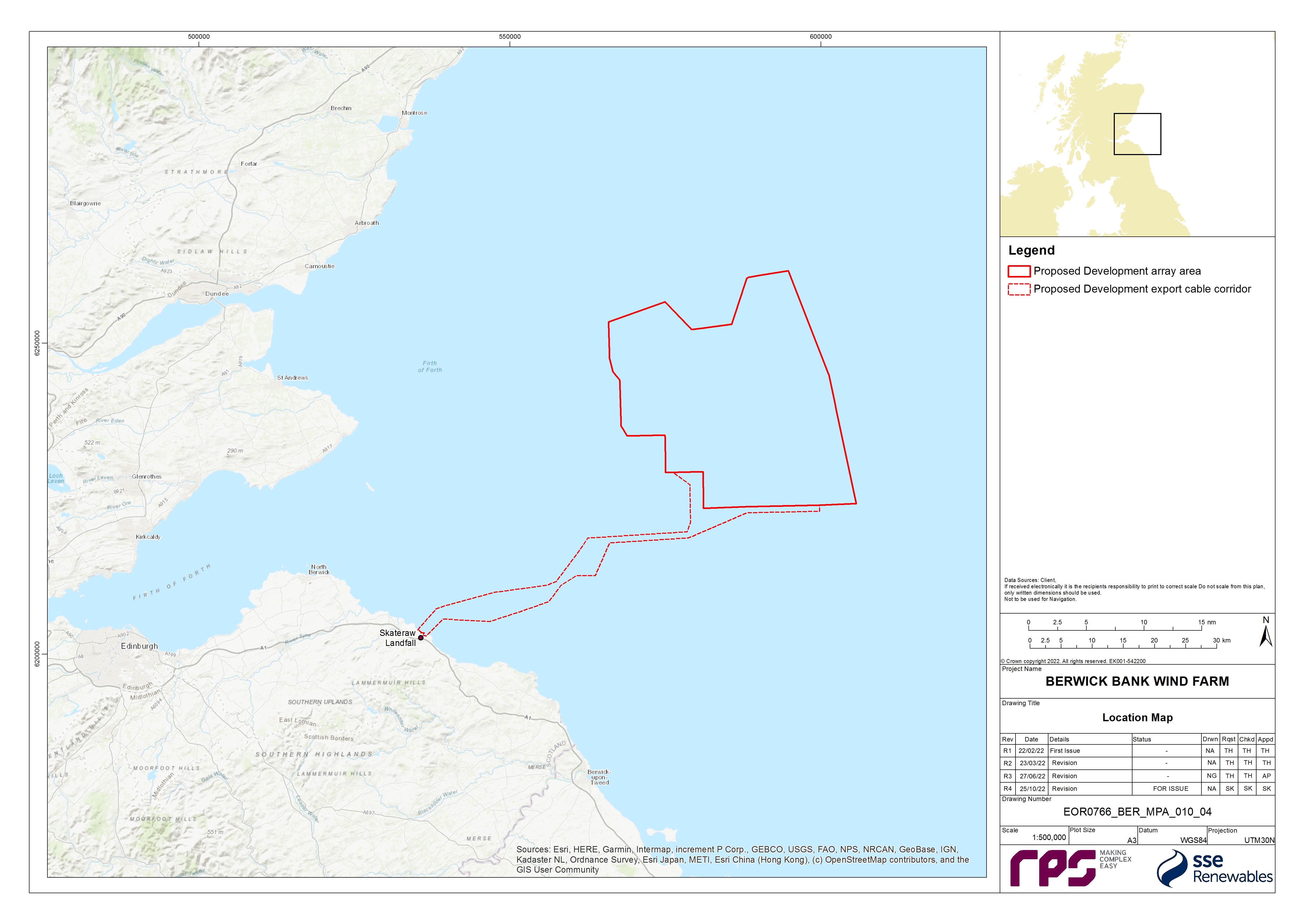
- The Applicant is developing the Berwick Bank Wind Farm (hereafter referred to as ‘the Project’). The Project is an offshore wind farm project located in the outer Firth of Forth and Firth of Tay, approximately 37.8 km east of the Scottish Borders coastline (St. Abb’s Head) and 47.6 km to the East Lothian coastline, in the southern region of the North Sea (Figure 1.1).
- The Project is comprised of both the offshore and onshore infrastructure required to generate and transmit electricity from the offshore components of the Project (hereafter referred to as the ‘Proposed Development’) array area to a Scottish Power Transmission (SPT) 400 kV Grid Substation located at Branxton, south-east of Torness Power station. The Proposed Development export cable corridor will make landfall on the East Lothian coast, specifically at Skateraw. The offshore components (the Proposed Development) include the offshore wind farm (the wind turbines, their foundations and associated inter-array cabling), together with associated infrastructure of the Offshore Transmission Asset (OTA), Offshore Substation Platforms (OSPs)/Offshore convertor station platforms, their foundations and the offshore export cables and cable protection.
- The Applicant is also developing an additional export cable grid connection to Blyth, Northumberland (the Cambois connection). Applications for necessary consents (including marine licences) will be applied for separately. The Cumulative Effects Assessment (CEA) of the Cambois connection is based on information presented in the Cambois connection Scoping Report (SSER, 2022e), submitted in October 2022.
- RPS Energy Limited (RPS) was commissioned to undertake a Marine Protected Area (MPA) assessment for the Proposed Development and this document provides the final MPA Assessment to accompany the Proposed Development Offshore EIA Report. It is intended that this document, alongside the Offshore EIA Report, will be used to inform an MPA assessment undertaken by Scottish Ministers.
1.2. Purpose of this Report
- Specific consideration of MPAs[1] is required for consent applications in UK waters. Under section 126 of the Marine and Coastal Access Act 2009, and section 83 of the Marine (Scotland) Act 2010, public authorities (in this case Marine Scotland - Licensing Operations Team (MS-LOT) on behalf of the Scottish Ministers) have specific duties for MPAs in relation to certain decisions. The public authority is required to consider whether the activity which is the subject of the application (i.e. marine licensable activities subject to a marine licence application) are capable of affecting (other than insignificantly) a protected feature in a Nature Conservation (nc) MPA or any ecological or geomorphological process on which the conservation of any protected feature in a ncMPA (hereafter referred to as an MPA) is dependant. MS-LOT must not grant authorisation of the activity unless the person applying for the authorisation satisfies MS-LOT that there is no significant risk of the activity hindering the achievement of the conservation objectives for the MPA. If the person seeking the authorisation is not able to satisfy MS-LOT that there is no significant risk of the activity hindering the achievement of the conservation objectives, then the authorisation must only be granted if:
- MS-LOT is satisfied that there are no other means of proceeding with the activity which would create a substantially lower risk of hindering the achievement of those objectives (to include proceeding in another manner or at another location);
- MS-LOT is satisfied that the benefit to the public of proceeding with the activity clearly outweighs the risk of damage to the environment that will be created by proceeding with it; and
- MS-LOT is satisfied that the person seeking the authorisation will undertake, or make arrangements for the undertaking of, measures of equivalent environmental benefit to the damage which the activity will or is likely to have in or on the MPA concerned.
- This report has been produced to provide evidence on whether the potential impacts of the Proposed Development give rise to a significant risk of hindering the conservation objectives of any MPA which may be screened in.
- This document is informed by guidance published by Marine Scotland (2014a) on how these assessments should be undertaken and by advice from the Statutory Nature Conservation Bodies (SNCBs) during consultation in the pre-application phase (as outlined in section 1.2.2). This MPA Assessment has been undertaken based on the Proposed Development information detailed within volume 1, chapter 3 of the Offshore EIA Report and section 1.4 of this report.
- This MPA Assessment should be read alongside the following chapters of the Offshore EIA Report, all of which have been drawn upon and referred to throughout this document:
- volume 2, chapter 7: Physical Processes;
- volume 2, chapter 8: Benthic Subtidal and Intertidal Ecology;
- volume 3, appendix 8.1: Benthic Subtidal and Intertidal Ecology Technical Report;
- volume 2, chapter 9: Fish and Shellfish;
- volume 3, appendix 6.1: Scoping Report; and
- volume 3, appendix 6.2: Scoping Opinion.
- This report is structured as follows:
- section 1.1: Introduction;
- section 1.3: Methodology, including description of the staged approach to the MPA Assessment following the relevant published guidelines, and how information presented in the Offshore EIA Report has been used to support the assessments presented herein;
- section 1.4: Project description, provides an outline description of the Proposed Development and describes the activities likely to be associated with the construction, operation, and maintenance, and decommissioning of the Proposed Development;
- section 1.4.3: Initial screening of MPAs which have conservation objectives with the potential to be affected by the Proposed Development;
- section 1.6: Background information on MPAs considered in the main assessment;
- section 1.7: Main assessment;
- section 1.8: Conclusion; and
- section 1.9: Summary.
1.2.2. Consultation
- This MPA Assessment has been informed by consultation with key stakeholders, including Marine Scotland Science (MSS), MS-LOT and NatureScot, through the scoping process and through the Benthic Ecology, Fish and Shellfish Ecology, and Physical Processes Road Map process. A summary of the key issues raised during pre-application consultation is outlined in Table 1.1 Open ▸ , together with how these issues have been considered in the production of this report.
![]()
Table 1.1: Summary of Key Consultation Issues Raised During Pre-Application Consultation Activities Undertaken of Relevance to the MPA Assessment
1.3. Methodology
- The Marine (Scotland) Act 2010 and the Marine and Coastal Access Act 2009 introduced provisions to support the management of MPAs. Under section 126 of the Marine and Coastal Access Act 2009 and section 83 of the Marine (Scotland) Act 2010, the public authority (MS-LOT) is required, when determining consenting application, to consider whether the activity applied for is capable of affecting (other than insignificantly) a protected feature in an MPA or any ecological or geomorphological process on which the conservation of any protected feature in an MPA is dependant.
- It was highlighted by MS-LOT and NatureScot in the Berwick Bank Wind Farm Scoping Opinion (MS-LOT, 2022) that the Offshore EIA Report must make a full and clear assessment of the potential impacts of the Proposed Development on all the designated features of any scoped in MPA. The Applicant confirmed during a Benthic Ecology, Fish and Shellfish Ecology and Physical Processes Road Map meeting (Meeting 1) on 3 September 2021 that this would be presented as a separate standalone document alongside the Offshore EIA Report.
- Marine Scotland’s Nature Conservation Marine Protected Areas: Draft Management Handbook (Marine Scotland, 2014a) recommends a staged approach to the assessment, starting with an initial screening process which should focus on what can reasonably be predicted as a consequence of the proposal and whether it is ‘capable of affecting (other than insignificantly)’ a protected feature of an MPA. This should then be followed by a main assessment which focuses on determining whether the exercise of a function would or might significantly hinder, or there is or may be a significant risk of the act hindering, the achievement of the conservation objectives. Full details of each of these stages of the approach have been provided in sections 1.3.2 and 1.3.3, respectively.
- If certain activities, sites or impacts are screened into the MPA Assessment process, these are then considered within the main assessment if significant risks to the achievement of the MPA conservation objectives have been identified by the initial screening.
1.3.2. Initial Screening
- Marine Scotland’s Nature Conservation Marine Protected Areas: Draft Management Handbook (Marine Scotland, 2014a) states that the initial screening stage should focus on what can reasonably be predicted as a consequence of the proposal and whether it is ‘capable of affecting (other than insignificantly)’ a protected feature of an MPA. The screening should use information that is currently available on the activities applied for and consider aspects such as the scale, timing and duration of proposed activities/developments. These considerations should include proposals for developments or activities out-with the boundary of an MPA.
- Firstly, consideration of ‘capable of affecting’ should result in removing from further consideration all proposals/functions which are not in any way connected to the protected feature(s). A capability that is both remote (in terms of likelihood of occurrence) and hypothetical should not be the basis of a conclusion that further assessment is required. This can be determined by considering whether the activity will exert pressures which the protected feature(s) are sensitive to (Marine Scotland, 2014a). Generic guidance and evidence on activities which exert pressures on the protected features is available through the online Feature Activity Sensitivity Tool (FeAST) sensitivity tool.
- Secondly, if the conclusion is that there is ‘capability of affecting’, the focus should then be on considering whether the activity will affect the protected features of an MPA, other than insignificantly. Consideration of the degree of pressure that could be exerted by the activity on a spatial basis should help to establish what level of effect might occur. Where it is concluded that the act or function is capable of affecting (other than insignificantly) the protected features of an MPA then a main assessment must be carried out considering the conservation objectives.
- In order to determine the ‘nearness’ of the activities associated with the Proposed Development for the purposes of this MPA Assessment, the same screening criteria as used for the Berwick Bank Habitats Regulations Appraisal (HRA) Offshore Screening Report (SSER, 2021b) were applied. These initial assumptions have subsequently been validated and refined through consultation with the SNCBs throughout the pre-application process (i.e. via the Benthic Ecology, Fish and Shellfish and Physical Processes Road Map process; see Table 1.1 Open ▸ ). These are as follows for the different protected features of MPAs:
- Benthic habitats/species and geodiversity features: there is the potential for indirect effects to sites designated for benthic features, as well as geodiversity features, as a result of impacts associated with increased suspended sediment concentrations (SSC) arising from construction activities or from changes to the hydrodynamic regime as a result of the presence of offshore infrastructure associated with the Proposed Development. The extent of these impacts is considered likely to extend beyond the boundaries of the Proposed Development. The zone of influence (ZOI) for such indirect effects is typically defined from the outputs of physical processes modelling to determine, for example, the fate of sediments resuspended during the construction process. Physical processes modelling had not been carried out at the Scoping stage. Therefore, a buffer of one mean tidal excursion was used initially to inform this area, with a reasonable level of precaution applied. One mean tidal excursion in the vicinity of the Proposed Development equates to approximately 6.5 km, as derived from the Atlas of UK Marine Renewable Energy Resources (ABPmer, 2008). For the purposes of MPA screening, a precautionary was adopted and this buffer was increased to 20 km. This buffer is considered to be sufficiently precautionary to capture all sites likely to be in the ZOI from direct and indirect effects associated with construction activities. This buffer has also been applied for geodiversity features of MPAs;
- Fish species: the HRA screening does not propose a screening distance for fish, as all European sites with diadromous fish species with the potential to be affected have been considered. For the purposes of this MPA Assessment (which does not consider diadromous fish, only marine fish) a nominal buffer of 100 km has been adopted to screen in MPA sites with fish features (e.g. sandeel species), on the basis that this is sufficiently precautionary to capture the ZOI from the project from key impacts such as underwater noise;
- Marine mammals: the HRA screening considers sites with cetaceans as qualifying interest features within a buffer that equates to the regional marine mammal study areas. For seals, all sites within the East Scotland Management Unit (MU) have been considered. These buffers are considered to be sufficiently precautionary to capture all sites likely to be in the ZOI from indirect effects associated with construction activities; and
- Ornithology: the HRA screening considers sites with breeding seabirds as qualifying interest features within a buffer that equates to the offshore ornithological regional study area. Published mean-maximum foraging ranges (plus one standard deviation (+1 S.D.)) in Woodward et al. (2019) were used to define the offshore ornithology regional study area. Northern gannet Morus bassanus has the largest foraging range (315.2 km ± 194.2 km) of the key species considered in the ornithology assessment. The offshore ornithology regional study area therefore extends 509.4 km from the Proposed Development. For seabirds in the non-breeding season, the ZOI is based on Furness (2015) which presents Biologically Defined Minimum Population Scales (BDMPS). These buffers are considered to be sufficiently precautionary to capture all sites likely to be in the ZOI from indirect effects associated with construction and operational activities. Following the establishment of the screening criteria and in view of the outputs of the collision risk, displacement and Population Viability Analysis assessments (volume 3, appendix 11.3 and appendix 11.6 of the Offshore EIA Report) the buffers have been refined and it was determined that no sites are likely to be in the ZOI in relation to ornithology.
- Additionally since Scoping, the assumptions applied for the MPA screening have been revisited in view of the outputs of the physical processes modelling undertaken for the Proposed Development (as reported in full in volume 2, chapter 7 of the Offshore EIA Report and volume 3, appendix 7.1 of the Offshore EIA Report). This modelling found that there would be no changes in tidal currents or sediment transport that would extend to the border of the 20 km study area and would further not disrupt beach and offshore bank morphological processes or destabilise coastal features. It is therefore concluded that the buffer applied is sufficiently precautionary to ensure all of the potentially affected benthic ecology receptors have been taken account of.
- The screening criteria applied however will depend in the nature of the MPA for example should none of the MPAs within the ZOI for the Proposed Development have seabirds as a qualifying feature then the ornithology screening criteria becomes redundant and will be screened out.
- Following identification of the MPAs considered in this initial screening, information presented within the Berwick Bank Wind Farm Scoping Opinion (MS-LOT, 2022) and the Offshore EIA Report has been reviewed to further refine this list of sites where the Proposed Development is capable of significantly affecting the protected/proposed features of those sites, or any ecological or geomorphological processes on which the conservation objectives of those features may depend. This included advice provided by the SNCBs and regulators on which sites should be included in the MPA Assessment as well as a review of outputs from volume 2, chapter 7 of the Offshore EIA Report to identify potential far field effects (e.g. increases in SSC, and changes to the tidal and wave regime due to the operational Proposed Development). Where robust evidence is available to screen out MPAs, this evidence has been referenced and justification presented within section 1.4.3.
- Individual impacts on designated protected features of the MPAs are also considered in the screening. Some impacts identified and assessed in volume 2, chapter 8 of the Offshore EIA Report were considered to be of sufficiently low risk of resulting in a likely significant effect on protected/proposed MPA features and have therefore been screened out (i.e. are considered insignificant). This may have been due, for example, to the extremely limited extent and/or duration of the impact, a lack of sensitivity of the receptors to the impact (as determined through the FeAST sensitivity tool or from the Advice on Operations Guidance documents), or due to control measures to be implemented by the Proposed Development to minimise the risk of any likely significant effect occurring. This is consistent with the guidance provided in Marine Scotland’s Nature Conservation Marine Protected Areas: Draft Management Handbook (Marine Scotland, 2014a).
1.3.3. Main Assessment
- The main assessment stage focuses on determining whether the exercise of a function would or might significantly hinder, or there is or may be a significant risk of the act hindering, the achievement of the conservation objectives of the MPA.
- In doing so, the Marine Scotland (2014a) guidelines suggest the decision-maker would use the information supplied by the applicant along with the licence application, advice from the SNCBs and any other relevant information to determine whether there is no significant risk of hindering the achievement of the stated conservation objectives for the Nature Conservation MPA. Aspects such as scale, timing and duration of the proposed activities or developments will all need to be considered. However, whilst the initial screening focuses on the protected features, the main assessment focuses on the potential impact on the achievement of the conservation objectives of the protected features. Therefore, this stage must also include consideration of the scale of the potential impact. Consideration of cumulative effects with other activities and functions should also be undertaken.
- In determining 'significant risk of hindering', the Marine Scotland (2014a) guidance states “The assessment should build on the initial screening assessment that considers the pressures associated with the activity and the sensitivity of the protected features, and information on the likely spatial overlap. To determine whether there is a 'significant risk of hindering' the achievement of the conservation objectives of the protected features of a nature conservation MPA aspects such as the intensity, frequency, and duration of any activities associated with the function or act should be considered.” This approach is presented in the Proposed Development interpretation of the Marine Scotland (2014a) guidance as outlined in the following section.
- If MS-LOT determines that there is or may be a significant risk of the proposal hindering the achievement of the conservation objectives, then they must notify the appropriate statutory conservation bodies (NatureScot for MPAs within 12 nautical miles (nm) or the Joint Nature Conservation Committee (JNCC) for MPAs out with 12 nm) of that fact.
- In those circumstances, in order to grant consent MS-LOT must determine that:
- there is no other means of proceeding with the project which would create a substantially lower risk of hindering the achievement of those objectives;
- the benefit to the public of proceeding with the project clearly outweighs the risk of damage to the environment that will be created by proceeding with it; and
- the person seeking the authorisation will undertake, or make arrangements for the undertaking of, measures of equivalent environmental benefit to the damage which the project will or is likely to have in or on the MPA concerned.
- When considering whether an activity may hinder the conservation objectives of a site, consideration should be given to the direct impact of an activity upon a protected feature as well as any applicable indirect impacts. Such an indirect impact could include changing the effectiveness of a management measure put in place to further the conservation objectives.
Assessment of risk to conservation objectives
- Volume 2, chapter 7 and chapter 8 of the Offshore EIA Report have presented assessments of the impacts of the Proposed Development on the physical and biological marine environment respectively, with definitions of impact, effect, and significance of effects on the identified receptors (including protected features of MPA) drawn from guidelines published in the Design Manual for Roads and Bridges (DMRB) (Highways Agency, 2020). These definitions have also been used within this MPA Assessment, with the term 'effect' to express the consequence of an impact. This is expressed as the 'significance of effect' and is determined by considering the magnitude of the impact alongside the importance, or sensitivity, of the receptor or resource, in accordance with defined significance criteria.
- Volume 2, chapter 8 of the Offshore EIA Report presents significance levels according to EIA/Ecological Impact Assessment (EcIA) methodologies. While this MPA Assessment will draw on the information presented in volume 2, chapter 8 of the Offshore EIA Report to support the conclusions made about effects of the Proposed Development on the achievement of conservation objectives for the relevant MPA, the EIA/EcIA approach has not been used to inform the conclusions made.
- As discussed in section 1.3.3, the main assessment has considered whether there is a risk that the Proposed Development could hinder the achievement of the conservation status of protected features and conservation objectives for the MPA. This includes assessing the risks in the context of the conservation status of each of the individual MPA protected features.
- The conservation objectives are detailed in section 1.6 for the sites and the protected features which have been considered in the main assessment. For the Firth of Forth Banks Complex MPA, further information on the conservation objectives for each of the protected features was available in the Supplementary Advice on Conservation Objectives for the site (JNCC, 2018a). The Supplementary Advice presents attributes, and sub-attributes, which describe the ecological characteristics of the protected features. The attributes each have an objective(s) which is either quantitative or qualitative, depending on the available evidence. The objective identifies the desired state to be achieved for the attribute and an objective of recover or conserve is set for each feature attribute.
- The main assessment considers each of the attributes for all protected features of the relevant MPA, where there is a clear impact-receptor pathway, to help determine whether there is a significant risk to the conservation objectives of the MPA. This draws on information presented within the relevant chapters of the Offshore EIA Report (see paragraph 9). When considering ecological attributes, the sensitivities of the species and communities (often represented by biotopes; see section 1.6.2) associated with the MPA features have been defined by the following, according to the Marine Evidence based Sensitivity Assessment (MarESA) (OSPAR, 2008; Laffoley et al., 2000):
- Intolerance or resistance, which is the likelihood of damage due to a pressure; and
- Recoverability or resilience, which is the rate of (or time taken for) recovery once the pressure has abated or been removed. Recoverability is the ability of a habitat to return to the state before the activity or event which caused change. It is dependent on its ability to recover or recruit subject to the extent of disturbance/damage incurred. Full recovery does not necessarily mean that every component species has returned to its prior condition, abundance or extent but that the relevant functional components are present, and the habitat is structurally and functionally recognisable as the initial habitat of interest.
- The FeAST tool allows users to investigate the sensitivity of marine features in Scotland's seas to pressures arising from human activities. This tool also bases its definition of sensitivity upon the features tolerance/intolerance as well as its recoverability (Marine Scotland, 2013). As these features are all located in Scottish waters both MarESA and FeAST were used to determine the sensitivity of protected features.
- Therefore, where sensitivity levels have been presented within the main assessment of this document, these are the definitions according to the MarESA and FeAST (Tillin et al., 2010) and not according to the definitions used to inform the EIA in volume 2, chapter 8 of the Offshore EIA Report, the latter also considering the importance (e.g. conservation, commercial or ecological) of the receptors. Use of the MarESA and FeAST definitions also ensures consistency with the JNCCs conservation advice for the Firth of Forth Banks Complex MPA and other MPAs. Information on these aspects of sensitivity of the species, communities, and biotopes to given impacts has been informed by the best available evidence following environmental impact or experimental manipulation in the field and evidence from the offshore wind industry and analogous activities such as those associated with cable installation and operations, aggregate extraction and oil and gas industries. Where applicable, MarESA and FeAST have also been drawn upon to support the assessments of sensitivity, including evidence of sensitivity to particular activities and benchmarks for the relevant pressures considered for each attribute.
- Following consideration of the relevant impacts of the Proposed Development on attributes and targets of the individual MPA features, conclusions are presented as to the potential risks of the activities associated with the Proposed Development hindering achievement of conservation objectives for the sites and consequently whether the conditions in section 126 of the Marine and Coastal Access Act 2009 and section 83 of the Marine (Scotland) Act 2010 can be met (see paragraphs 24 and 26) (i.e. there is no significant risk of the activity hindering the achievement of the conservation objectives stated for the MPA).
- If it cannot be concluded that there is no significant risk of the activity hindering the achievement of the conservation objectives of an MPA, and that mitigation or consideration of alternative means of proceeding, would not create a substantially lower risk of hindering achievement of the conservation objectives (see paragraph 28), the Applicant must undertake, or make arrangements for the undertaking of, measures of equivalent environmental benefit to the damage which the project will or is likely to have in or on the MPA concerned. The assessment outcomes presented within this MPA Assessment demonstrate that there is no significant risk of the Proposed Development hindering the achievement of the conservation objectives of an MPA (see section 1.7), and so these latter stages are not relevant.
1.4. Project description
- This section provides an outline description of the Proposed Development and describes the activities likely to be associated with the construction, operation, and maintenance, and decommissioning of the Proposed Development. It summarises the design and components of the Proposed Development infrastructure, based on design concept and current understanding of the environment associated with the Proposed Development from site specific survey work.
- The Project Design Envelope (PDE) approach has been adopted for the assessment of the Proposed Development, which allows for a project to be assessed on the basis of maximum project design parameters. This provides flexibility, while ensuring all potential likely significant effects (positive or negative) are assessed. Those parameters presented include a range of potential values up to and including the maximum project design parameters.
- The Proposed Development will be located in the central North Sea, 43 km offshore of the East Lothian coastline and 33.5 km from the Scottish Borders coastline at St, Abbs. The Proposed Development is already the subject of Agreements for Lease (AfL). The Proposed Development operational lifetime is 35 years.
- The Proposed Development encompasses the:
- Proposed Development array area: This is where the offshore wind farm will be located, which will include the wind turbines, wind turbine foundations, inter-array cables, and a range of offshore substations and offshore interconnector cables; and
- Proposed Development export cable corridor up to mean high water springs (MHWS): This is where the offshore electrical infrastructure such as offshore export cables will be located.
1.4.2. Offshore Infrastructure
Overview
- The key offshore components of the Proposed Development (seaward of MHWS), as shown in Figure 1.2 Open ▸ , will include:
- up to 307 wind turbines (each comprising a tower section, nacelle and three rotor blades) and associated support structures and foundations;
- up to ten Offshore Substation Platforms (OSPs)/Offshore convertor station platforms and associated support structures and foundations to accommodate for a combined High Voltage Alternating Current (HVAC)/High Voltage Direct Current (HVDC) transmission system solution or a HVDC solution;
- estimated scour protection of up to 10,984 m2 per wind turbine and 11,146 m2 per OSP/Offshore convertor station platforms;
- a network of inter-array cabling linking the individual wind turbines to each other and to the OSPs/Offshore convertor station platforms plus inter-connections between OSPs/Offshore convertor station platforms (approximately 1,225 km of inter-array cabling and 94 km of interconnector cabling); and
- up to eight offshore export cables connecting the OSPs/Offshore convertor station platforms to landfall at Skateraw. Offshore export cables design includes both HVAC and HVDC solutions.
- The Applicant is also developing an additional export cable and grid connection to Blyth, Northumberland (hereafter the “Cambois connection”). Applications for the necessary consents (including marine licences) will be applied for separately once further development work has been undertaken on this offshore export corridor. The Cambois connection has been included as a cumulative project for the purposes of the offshore EIA and assessed based on the information presented in the Cambois connection Scoping Report submitted in October 2022 (SSER, 2022e). An EIA and HRA will be prepared to support any relevant consent applications that are required to deliver the Cambois connection which will also consider cumulative effects with the Proposed Development.
Figure 1.2: Project Overview[3]
Wind turbines
- The Proposed Development will comprise up to 307 wind turbines, with the final number of wind turbines dependent on the capacity of individual wind turbines used, and also environmental and engineering survey results. The PDE considers a range of wind turbines with parameters reflective of potential generating capacities, allowing for a degree of flexibility to account for any anticipated developments in wind turbine technology while still allowing each of the impacts assessed within the technical assessments (volume 2, chapters 7 to 21), to define the maximum design scenario for the assessment of effects. Consent is therefore sought for the physical parameters of the wind turbines which form the basis of the maximum design scenario such as maximum tip height or rotor diameter, as presented in the PDE rather than actual installed capacity of the wind turbines.
- A range of wind turbine options have been considered. The parameters in Table 1.2 Open ▸ provide for both the maximum number of wind turbines, as well as the largest wind turbine within the PDE. As set out in paragraph 1.2.8, the coupling of these maximum dimensions will not provide a realistic design scenario; as a reduced number of wind turbines will likely be required if an increased rated output of wind turbine model is chosen.
- The wind turbines will comprise a horizontal axis rotor with three blades connected to the nacelle of the wind turbine. Figure 1.3 Open ▸ illustrates a schematic of a typical offshore wind turbine.
Figure 1.3: Indicative Schematic of an Offshore Wind Turbine on a Jacket Foundation
- The maximum rotor blade diameter will be no greater than 310 m, with a maximum blade tip height of 355 m above LAT and a minimum lower blade tip height of 37 m above LAT. A scheme for wind turbine lighting and navigation marking will be approved by Scottish Ministers following consultation with appropriate consultees post consent. Outlines plans have been provided with the Application in volume 4 of this Offshore EIA Report.
- The layout of the wind turbines will be developed to best utilise both the available wind resource, suitability of seabed conditions and wake effects, while seeking to minimise environmental effects and impacts on other marine users (such as fisheries and shipping routes).
- Figure 1.4 Open ▸ presents an indicative wind farm layout based on the maximum design scenario of 307 wind turbines, while Figure 1.5 Open ▸ displays an indicative wind farm layout should 179 wind turbines were to be installed. The final layout of the wind turbines will be confirmed at the final design stage post consent with details being submitted to Marine Scotland Licensing Team (MS-LOT) for approval.
Table 1.2: Design Envelope: Wind Turbines
Figure 1.4: Berwick Bank Wind Farm Preliminary Indicative Layout for 307 Wind Turbines Each Square Being 5 km x 5 km)
Figure 1.5: Berwick Bank Wind Farm Preliminary Indicative Layout for 179 Wind Turbines Each Square Being 5 km x 5 km)
- grease;
- synthetic oil;
- hydraulic oil;
- gear oil;
- lubricants;
- nitrogen;
- water/glycerol;
- transformer silicon/ester oil;
- diesel fuel;
- sulphur hexafluoride SF6; and
- glycol/coolants
Wind turbine foundations and support structures
- To allow for flexibility in foundation choice, two types of wind turbine support structures and foundations are being considered for the Proposed Development:
- piled jacket; and
- suction caisson jacket.
- Foundations will be fabricated offsite, stored at a suitable port facility (if required) and transported to site by sea. Specialist vessels will transport and install foundations. Scour protection (typically rock) may be required on the seabed and will be installed before and/or after foundation installation. The following section provides an overview of the foundation types which are being considered for wind turbines - foundation structures for OSPs/Offshore convertor station platforms are discussed in paragraph 58 and seq.
Piled jacket foundation
- The piled jacket foundations will be transported to site by sea. Once at site, the jacket foundation will be lifted by the installation vessel using a crane and lowered towards the seabed in a controlled manner. Piled jacket foundations are formed of a steel lattice construction (comprising tubular steel members and welded joints) secured to the seabed by driven and/or drilled pin piles attached to the jacket feet (as illustrated in Figure 1.6 Open ▸ ). The hollow steel pin piles are typically driven or drilled into the seabed, relying on the frictional and end bearing properties of the seabed for support. The PDE for jacket foundations with pin piles is provided in Table 1.3 Open ▸ .
Table 1.3: Design Envelope: Wind Turbine Jacket Foundation with Pin Piles
Figure 1.6: Indicative Schematic of a Jacket Foundation with Pin Piles
Suction caisson jacket foundations
- Suction caisson jacket foundations are formed with a steel lattice construction (comprising tubular steel members and welded joints) fixed to the seabed by suction caissons installed below each leg of the jacket (as per Figure 1.7 Open ▸ ). The suction caissons are typically hollow steel cylinders, capped at the upper end, which are fitted underneath the legs of the jacket structure. They do not require a hammer or drill for installation.
- The suction caisson jacket foundations will be transported to site by sea. Once at site, the jacket foundation will be lifted by the installation vessel using a crane and lowered towards the seabed in a controlled manner. When the steel caisson reaches the seabed, a pipe running up through the stem above each caisson will begin to suck water out of each bucket. The buckets are pressed down into the seabed by the resulting suction force. When the bucket has penetrated the seabed to the desired depth, the pump is turned off. A thin layer of grout is then injected under the bucket to fill the air gap and ensure contact between the soil within the bucket, and the top of the bucket itself. The PDE for jacket foundations with suction caissons is provided in Table 1.4 Open ▸ .
Table 1.4: Design Envelope: Wind Turbine Jacket Foundation with Suction Caisson
Figure 1.7: Indicative Schematic of a Jacket Foundation with Suction Caissons
Offshore substation platforms and offshore convertor station platforms
- The Applicant has three signed grid connection agreements with the network operator. Two agreements are for connection at the Branxton substation, with a third additional connection at Blyth, Northumberland (the Cambois connection). The Cambois connection agreement, was confirmed in June 2022 following National Grid’s Electricity System Operator (NGESO) Holistic Network Review, and will enable the Project to reach full generating capacity (4.1 GW) by early 2030’s.
- The installation of offshore export cables including landfall methodologies for the Cambois connection is being consented separately to the Proposed Development but has been considered cumulatively as part of this Application.
- The Project is currently considering HVAC and HVDC solutions for the Offshore Transmission Infrastructure. These solutions include:
– up to eight HVAC OSPs to facilitate connections to Branxton and two HVDC Offshore convertor station platforms that will be required for the Cambois connection (see Table 1.5 Open ▸ ); or
– up to five larger HVAC OSPs to facilitate connections to Branxton and two HVDC Offshore convertor station platforms that will be required for the Cambois connection (see Table 1.6 Open ▸ ).
- HVDC Option: Up to five HVDC Offshore convertor station platforms, two for the Branxton connection and two for the additional Cambois connection (see
Table 1.7
Open ▸
) This also includes an offshore interconnector platform.
- These offshore platforms will be utilised as OSPs/Offshore convertor stations platforms which transform electricity generated by the wind turbines to a higher voltage and thereby allowing the power to be efficiently transmitted to shore. The platforms’ topsides size will depend on the final electrical design for the wind farm but maximums could be up to 100 m (length) by 80 m (width) and up to 80 m in height (above LAT), excluding the helideck, antenna structure or lightning protection. The maximum design parameters for OSPs/Offshore convertor station platforms are presented in Table 1.5 Open ▸ and Table 1.6 Open ▸ (Combined Options) and Table 1.7 Open ▸ (HVDC Option). It is proposed that the OSP/Offshore convertor station platform foundations will be painted yellow from the water line up to the topside structure and the topside will be painted light grey.
Table 1.5: Design Envelope: OSP/Offshore Convertor Station Platform (Combined Option A)
Table 1.6 Design Envelope: OSP/Offshore Convertor Station Platform (Combined Option B)
Table 1.7: Design Envelope: Offshore Convertor Station Platforms (HVDC Option)
- Table 1.8 Open ▸ presents the consumables which will be required for the OSPs/Offshore convertor station platforms at the Proposed Development. In addition, Uninterruptible Power Supply (UPS) batteries, fire suppression systems, HVAC coolant and SF6 will also be required.
Table 1.8: Design Envelope: Consumables for the Offshore Substation Platforms (per OSP/Offshore Convertor Station Platform)
- Project design layout has not yet been finalised, however the OSPs/Offshore convertor station platforms will be located within the Proposed Development array area. The offshore platforms will be installed with piled jacket foundations or suction caissons. The PDE for offshore platforms piled jacket foundations is shown in Table 1.9 Open ▸ (Combined Option A), Table 1.10 Open ▸ (Combined Option B) and Table 1.11 Open ▸ (HVDC Option). The PDE for offshore platforms suction caissons foundations is shown in Table 1.12 Open ▸ (Combined Option A), Table 1.13 Open ▸ (Combined Option B) and Table 1.14 Open ▸ Table 1.14 Open ▸ (HVDC Option).
Table 1.9: Maximum Design Envelope: Jacket Foundation with Pin Piles for OSPs/Offshore Convertor Station Platforms (Combined Option A)
Table 1.10 Maximum Design Envelope: Jacket Foundation with Pin Piles for OSPs/Offshore Convertor Station Platforms (Combined Option B)
Table 1.11: Maximum Design Envelope: Jacket Foundation with Pin Piles for OSPs/Offshore Convertor Station Platforms (HVDC Option)
Table 1.12: Maximum Design Envelope: Suction Caisson Foundation for OSPs/Offshore Convertor Station Platforms (Combined Option A)
Table 1.13: Maximum Design Envelope: Suction Caisson Foundation for OSPs/Offshore Convertor Station Platforms (Combined Option B)
Table 1.14: Maximum Design Envelope: Suction Caisson Foundation for OSPs/Offshore Convertor Station Platforms (HVDC Option)