

Scottish Borders – overview of coastal character
- The short section of coast from St Abb’s Head to Eyemouth (SA 19) is diverse and rugged with high sea cliffs that give it a barren, exposed character. The coastal edge rises to isolated volcanic cliffs at St Abb’s Head, which encloses dramatic open views to the North Sea. The popular headland is solely accessible via footpaths. Coastal settlement lies in sheltered folds at Coldingham, Eyemouth and St Abbs. Inland, farmsteads widely dispersed along minor roads lie within the large rolling countryside with wooded areas. Transport corridors run along the clifftops. The Berwickshire Coast Path runs alongside the coast.
- The relatively linear coastline from Eyemouth to Berwick-upon-Tweed (SA 20) mainly comprises rocky cliffs with several small headlands, including Agate Point and Horse Head, and an enclosed harbour at Burnmouth. Inland, the open and undulating landscape is medium to large scale.
Coastal Character - England
- The character of the English coastline within the SLVIA study area is described at a national scale in the Seascape Character Assessment for the North East Inshore and Offshore Marine Plan Areas (MMO, 2018), by CCA (Forth and Tay Offshore Windfarm Developer Group, 2011) and onshore LCTs in the Northumberland County Council Landscape Character Assessment (Northumberland County Council, 2010).
- In order to allow consistency of baseline description and assessment with the Scottish part of the Special Landscape Area (SLA) study area, the baseline description of the coastal character of the Northumberland coast is based on ‘SA21 Berwick-upon-Tweed to Holy Island’ (Figure 15.3) (Forth and Tay Offshore Windfarm Developer Group, 2011) and is supplemented by the baseline information provided in the Northumberland County Council Landscape Character Assessment (Northumberland County Council, 2010) and Seascape Character Assessment for the North East Inshore and Offshore Marine Plan Areas (MMO, 2018). Berwick-upon-Tweed overlooks the North Sea with Eyemouth containing views north. The busy A1 and ECML closely follow the coast while the Berwickshire Coast Path runs close to the shoreline.
- These CCAs, MCAs and associated coastal LCTs in England are listed in Table 15.10 Open ▸ and form the baseline coastal characterisation and mapping for the SLVIA, against which the seascape effects of the Proposed Development are assessed.
Table 15.10: CCAs, MCAs and Associated Coastal LCTs in England
- A description of the baseline landscape character and sensitivity to change for each of the above CCAs that are identified in the preliminary assessment ( Table 15.26 Open ▸ ) as requiring detailed assessment, is set out in Section 15.11. An overview of the coastal character in the Northumberland region in the SLVIA study area is provided below.
Northumberland – overview of coastal character
- The low-lying coastline between Berwick-upon-Tweed and Holy Island (SA 21) has a narrow, windswept coastal plain with wide views east towards the sea. The coastal scenery is diverse with spectacular high cliffs, offshore islands, and rocky headlands to the north; and wide sweeping sandy bays backed by sand dunes and intertidal flats, to the south. The landscape behind the coast is predominantly intensively farmed arable land with limited tree cover, and permanent pasture/semi-natural grassland typical of the valleys and coastal fringes. The River Tweed crosses the coastal plain at Berwick-upon-Tweed. Settlement comprises a dispersed pattern of isolated farmsteads, small, nucleated villages, fishing villages and small coastal resort towns. Berwick-upon-Tweed and Holy Island are distinctive features of the coast. Prominent medieval castles, fortifications and religious buildings reflects the historic ecclesiastical influence, and strategic importance of this coastline. The shoreline south of Berwick-upon-Tweed comprises Lindisfarne National Nature Reserve. The Northumberland Coast Path runs parallel to the coast.
- The key coastal landscape character areas in the Northumberland part of the SLVIA study area form the North Northumberland Coastal Plain:
- 1a. Broad River Mouth - Tweed River Mouth;
- 3a. Haggerston;
- 4a. North Tweed Coast; and
- 5a. Holy Island Coast.
- The coastline from the border with Scotland north of Berwick-upon-Tweed to Newbiggin Point (MCA 23: Rural Northumberland and Coastal Waters) consists of long crescent-shaped sandy bays and rocky headlands with offshore islands. The shallow inshore waters include the coastal lagoon behind Holy Island, and rocky outcrops of the sea form Coquet Island and the Farne Islands. Settlements and small harbours are associated with bays scattered along the coast. Lighthouses at Coquet Island, Longstone and Farne are notable, particularly at night within the dark skies of this relatively remote coast. While shipping lanes lie well off the coast, inshore waters are characterised by smaller fishing and recreational vessels. Coastal views encompass the largely undeveloped landscape and open sea horizons, with distinctive features including offshore islands and fortified castles at Warkworth, Dunstanburgh, Bamburgh. The island of Lindisfarne and its connecting causeway is particularly notable. Much of this coastline falls within the Northumberland Coast AONB and North Northumberland Heritage Coast.
- The seascape area located off the coast of Newcastle upon Tyne and Sunderland (MCA 25: Farne Deeps) does not have an adjacent coastline and is distinguished from the area to the north (MCA 26: Berwick Bank) by generally deeper water often over 80 m in depth. The seascape has a distant visual relationship with the coast and Tyne Estuary to the west. The movement of large ships and smaller recreational yachts further out to sea, strongly influences the area. As the deepest open water in the region, the sea environment is rich and supports a productive fishing industry. Oil rigs are located further offshore. This seascape may be visible from parts of the Northumberland National Park and North Northumberland Heritage Coast.
- Off the coast of Northumberland, the offshore area of water (MCA 26: Berwick Bank) is distinguished from Farne Deeps (MCA 25) by its generally shallower water. Clearly influenced by the coast in the west of the area, the east is typically exposed and remote. Closer to the coast are important fishing grounds and numerous wrecks as well as a firing practice range. Tidal races and currents associated with sudden changes in depth and undersea glacial features such as Berwick Bank occur in the west and north. This offshore area is inter-visible with the Northumberland Coast AONB and North Northumberland Heritage Coast.
- The extensive offshore area of open waters over a deep plain of approximately 70-90 m with occasional deeply incised troughs (MCA 28: Shallow Hole Plain), is bounded by the transition to Scottish waters; the offshore North Sea oilfields; and the reduced water depth of Dogger Bank to the north, east and south, respectively. The seascape includes part of the distant offshore North Sea. Shipping activity en route to continental European ports and oil platforms lies further east.
15.7.5. Landscape Designations
Designated Sites/Defined Areas
- The Proposed Development is located beyond the boundaries of any areas subject to international, national or regional landscape designation in Scotland and England intended to protect landscape quality. Certain designated landscapes or defined areas found within the study area in Scotland and England have been designated or defined due to their scenic qualities or historic landscape qualities and are of relevance to the SLVIA as shown in Figure 15.4
- The landscape of certain parts of the SLVIA Study Area have been designated or defined due to their scenic qualities or historic landscape qualities as shown in Figure 15.4 The ZTV has been used to identify landscape designations and defined areas within the SLVIA Study Area that may have visibility of the Proposed Development, as shown in Figure 15.10 All other landscape designations or defined areas that are not within the ZTV are scoped out of the SLVIA and are not considered further (as there is no potential for the Proposed Development to result in effects on receptors outside the ZTV).
- Designated sites and defined areas identified for the SLVIA chapter are described in Table 15.11 Open ▸ below.
Table 15.11: Landscape Designations and Defined Areas
- A preliminary assessment of the potential for the Proposed Development to result in significant effects on the perceived character of these landscape designations and defined areas is undertaken in Table 15.26 Open ▸ . A description of the special qualities of each landscape designation and how they contribute to the value of the landscape/coastal character is provided in the assessment of each CCA in Section 15.11 ( Table 15.27 Open ▸ to Table 15.38 Open ▸ ). The majority of the designated landscapes in the SLVIA study area are local landscape designations, providing an indication of their value at the local level.
Northumberland Coast AONB
- The SLVIA study area includes part of the area covered by the nationally designated Northumberland Coast AONB designation, within the north of the County between Berwick upon Tweed and Holy Island (Figure 15.4). The Northumberland Coast AONB covers an area of 138 km2 along 64 km of coastline from just south of Berwick-upon-Tweed to the Coquet Estuary and is located 47.9 km from the Proposed Development at its closest point. The AONB is only 2.5 km wide at its widest point, and contains a variety of features of natural, historical and cultural value.
- The National Parks and Access to the Countryside Act 1949 provided the framework for the establishment of National Parks and AONBs. In turn, the Countryside and Rights of Way Act 2000 (CRoW) amended the provisions relating to AONBs. In summary the provisions confer a power on Natural England, to designate an area as an AONB where an area’s outstanding natural beauty is such that it appears desirable to do. Section 82(1) of CRoW defines an AONB in England as: ‘An area that is not in a National Park but which appears to Natural England to be of such outstanding natural beauty that it is desirable that the protective provisions of Part IV of The Countryside and Rights of Way Act 2000 should apply to it for the purpose of conserving and enhancing the area’s natural beauty’. The statutory duty therefore is to have regard to this purpose of the AONB i.e., the conservation and enhancement of its natural beauty.
- The special qualities of the Northumberland Coast AONB have been defined in the Northumberland Coast AONB Management Plan (2020-2024), as indicators of what comprises its natural beauty. These special qualities are set out in Part One of the AONB Management Plan 2020-2024 and in Table 15.12 Open ▸ below.
Table 15.12: Northumberland Coast AONB Special Qualities
North Northumberland Heritage Coast
- The North Northumberland Heritage Coast is largely coincidental with the AONB (Figure 15.4) between Cocklawburn Beach in the north to the edge of the SLVIA study area at Seahouses in the south. A further area of coastline to the north is also defined within the Heritage Coast outside the AONB, consisting of the Berwickshire coastline at Berwick-upon-Tweed and the Heritage Coast includes areas of sea, which are not part of the AONB.
- Heritage Coasts were established to protect and conserve the best stretches of undeveloped coast in England. There are no statutory requirements or powers associated with the Heritage Coast definition, however, they are afforded policy protection in England under paragraph 178 of the National Planning Policy Framework:
Within areas defined as Heritage Coast (and that do not already fall within one of the designated areas mentioned in paragraph 176), planning policies and decisions should be consistent with the special character of the area and the importance of its conservation. Major development within a Heritage Coast is unlikely to be appropriate, unless it is compatible with its special character.
- As its geographic area is largely coincident with the Northumberland Coast AONB, and their purpose aligns with the statutory purpose of the Northumberland Coast AONB, the effects of the Proposed Development on the North Northumberland Heritage Coast are considered as integral to the assessment of the Northumberland Coast AONB set out in this SLVIA. Cultural heritage matters are also addressed in Chapter 16: Cultural Heritage.
15.7.6. Future Baseline Scenario
- The EIA Regulations require that a “a description of the relevant aspects of the current state of the environment (baseline scenario) and an outline of the likely evolution thereof without development as far as natural changes from the baseline scenario can be assessed with reasonable effort ,on the basis of the availability of environmental information and scientific knowledge” is included within the Offshore EIA Report.
- The baseline character of the landscape, coastline and seascape within the study area is dynamic and is likely to evolve and change in future because of the effects of climate change, land use policy, environmental improvements and development pressures, irrespective of whether the Proposed Development progresses to construction and operation or not.
- A range of policies impact on the management of the landscape, coastline, and seascape, ranging from national policy and regulation, through to community strategies and development frameworks. Planning policies covering the landscape, coastal and seascape resource within the study area generally seek to conserve and enhance the natural beauty of the area, while recognising the need to adapt to inevitable change over time, particularly in areas where natural processes may drive more rapid change, such as coastal landscapes shaped by coastal processes, changing agricultural practices and/or changes to the integrity of agricultural character, and the need to respond to development pressures that reflect the changing needs of society.
- There is overwhelming evidence that global climate change, influenced by the human use of fossil fuels, raw materials, and intensive agriculture, is occurring (IPCC 2014). Any notable change in climate is likely to present potential changes to the coastline and inland parts of the study area in a variety of ways. The legislative framework already exists to ensure that no net loss of internationally important habitat occurs, but there remains a need to increase understanding of the potential effects of climate change on the characteristic landscapes of the study area and to develop longer term strategies that will mitigate any adverse effects of climate change. NatureScot's Climate Change Commitments were published in 2019 and adaption principles are embedded in Scotland’s Biodiversity: A Route Map to 2020 (NatureScot, 2015).
- An assessment of the impacts of climate change on Scottish landscapes (Land Use Consultants, 2011) found that changes in the coastal environment ‘will result from direct impacts resulting from sea level rise and the increased risk of flooding from surge events, together with the impacts of adaptation responses. These will result in changes in the nature and distribution of coastal habitats, erosion and deposition, changing morphology, loss of land, increased flood defences (hard and soft), increased risk of flooding and implications for land use’. It also recognises that additional changes within the coastal landscape ‘may include offshore energy generation in order to help attain the Scottish Government’s greenhouse gas emission targets’ and that ‘future development of wind turbines may be concentrated in the shallower waters off the east coast’, such that the combined influence of direct, mitigation and adaptation changes ‘may be greatest in coastal landscapes’.
- Recent development management decisions / planning decision precedent has established and accepted seascape and landscape change from both offshore and onshore wind farm development within the study area. In addition to the Neart na Gaoithe and Seagreen 1 offshore wind farms which are under construction (and assumed to be part of the landscape and visual baseline), there will be further change in the outer Firth of Forth and Firth of Tay seascape through the construction of the consented Inch Cape Offshore Wind Farm (Inch Cape) (Figure 15.16), consisting of up to 72 wind turbines (with assumed maximum blade tip height of 291 m above LAT) located approximately 15.6 km from the closest point of the Angus coastline. Crucially Inch Cape is located between the Proposed Development and the Angus coastline, and closest to the coast, such that it will generally be viewed to the foreground of the Proposed Development. Inch Cape is predicted (ICOWL, 2018) to give rise to a number of daytime and night-time significant effects on seascape, landscape and visual amenity when considered in addition to Neart na Gaoithe and Seagreen 1, due to the height and horizontal extent of the wind turbines. There will be significant changes resulting from Inch Cape (ICOWL, 2018) on the coastal character of Angus and Fife between Montrose Bay and Fife Ness (15.6 km to 32 km from Inch Cape) and on the visual amenity of residents with open seaward views from the coastal settlements of Montrose, Braehead of Lunan, Arbroath, Carnoustie, St Andrews and Kingsbarns; walkers on the majority of the route of the Fife Coastal Path; for cyclists on parts of NCN1 and passengers on main railway line between Carnoustie and Arbroath. Significant night-time effects were also predicted from the aviation lighting of Inch Cape Wind Farm seen in addition to either the Seagreen 1 or Neart na Gaoithe lit wind turbines, at the same coastal areas and viewpoints as those for which significant day time effects are predicted, within approximately 30km of the nearest Inch Cape lit wind turbine.
- The future baseline conditions are likely to include the introduction of further wind energy development onshore, including the consented Crystal Rig IV wind farm, and the less-certain scenario of schemes at appeal or currently at the scoping stage progressing through to construction. Consented and application stage onshore wind farms are considered as part of the Tier 2 Cumulative Effects Assessment (CEA) (Section 15.12.3).
- Further development pressures which may change the baseline conditions include suburbanisation and increased tourist development influences, particularly around the coastal landscapes and established coastal towns within the study area, which have potential to increase the developed influence and reduces perceived naturalness of the coastline.
15.7.7. Data Limitations and Assumptions
- There are some data limitations relating to seascape, landscape and visual amenity however these do not affect the robustness of the assessment of this EIA Report as the gaps are limited and would not affect the assessments of likely significance assessed for relevant receptors.
- There are limitations in the production of photomontage and wireline visualisations and ZTVs as assessment tools, and limitations in the accuracy of digital terrain model (DTM) data, which are described in Appendix 15.1 SLVIA Methodology. The use of detailed terrain models (OS Terrain 5), production of visualisations to recognised standard and field survey assessment of impacts minimises these limitations.
- There are practical limitations to shooting viewpoint photographs only in very good or excellent visibility and at particular times of day. It is a limitation of the visual representations that photographs were not taken during summer months, when visibility conditions are typically better, however limitations have been minimised through the timing of surveys during the most favourable periods of very good or excellent visibility during surveys between October 2021 – January 2022. These limitations relating to winter viewpoint photography do not affect the assessments of likely significance assessed for relevant receptors, which assume optimum visibility using the wireline visualisations to inform assessments and are informed by professional judgement of the effects of offshore wind turbines at similar range gained from consented projects that provide precedent for magnitude of change judgements. It is a limitation of the visual representations that baseline photography from the Isle of May and Bell Rock lighthouse has not been undertaken, with wireline visualisations provided from these locations.
- Met Office visibility data has limitations in its application to judgements about wind farm visibility. The visibility data provides some understanding and evidence basis for evaluating the visibility of the wind turbines against their background. Effects have not been downgraded either in magnitude or significance due to variations as a result of weather/visibility and how frequently/infrequently the effects will be experienced. Effects are based on the worst-case with clear visibility and need to be considered in context of the limited time over which effects will actually occur.
- Some data limitations have arisen due to restrictions or delay to site surveys as a result of COVID-19 restrictions, including closure of, and therefore lack of access to certain visitor attractions locations such as Tantallon Castle, however limitations have been minimised through the timing of surveys when travel and access restrictions were eased.
- There are limitations in terms of available project design data for other projects considered as part of the landscape and visual baseline (Neart na Gaoithe and Seagreen 1) or as part of the CEA (Section 15.12). The MDS considered for each project is set out in Table 15.42 Open ▸ .
15.8. Key Parameters for Assessment
15.8.1. Maximum Design Scenario
- The maximum design scenario identified in Table 15.13 Open ▸ has been selected as having the potential to result in the greatest effect on seascape, landscape and visual receptors. These scenarios haves been selected from the details provided in volume 1, chapter 3 of the Offshore EIA Report. Effects of greater adverse significance are not predicted to arise should any other development scenario, based on details within the Project Design Envelope (e.g., different infrastructure layout), to that assessed here, be taken forward in the final design scheme.
- A Project Design Envelope (PDE) approach has been adopted in line with guidance (Scottish Government, 2022), as described in volume 1, chapter 3 of the Offshore EIA Report, which sets out a series of design scenarios for the project, containing both a realistic minimum and maximum extent/value for key project components. Further details of the use of a PDE or “Rochdale envelope” are also provided in volume 1, chapter 6: EIA Methodology.
- Assessing using a parameter-based design envelope approach means that the assessment considers a maximum design scenario (MDS) whilst allowing the flexibility to make improvements in the future in ways that cannot be predicted at the time of the application. The assessment of the MDS for each receptor establishes the maximum potential adverse impact and as a result, impacts of greater adverse significance would not arise should any other development scenario, to that assessed within this chapter, be taken forward in the final scheme design.
- The design parameters that have been identified to be relevant to seascape, landscape and visual amenity to establish the MDS for the SLVIA are outlined in Table 15.13 Open ▸ below and reflect the PDE, which is described in full in volume 1, chapter 3 of this Offshore EIA Report.
- Considering all of the factors described below in Table 15.13 Open ▸ , the MDS indicative layout shown in Figure 15.1a, is considered to be representative of the worst case in terms of seascape, landscape and visual effects, and is the MDS assessed in the SLVIA and shown in the visual representations in Appendix 15.2 (Figure 15.21 to Figure 15.75). Justification for the use of this MDS for the SLVIA, as opposed to other scenarios, is provided in Table 15.13.
Table 15.13: Maximum Design Scenario Considered for the Assessment of Potential Impacts on Seascape, Landscape and Visual Receptors
15.8.2. Impacts Scoped out of the Assessment
- On the basis of the baseline environment and the project description outlined in volume 1, chapter 3 of the Offshore EIA Report, a number of impacts are proposed to be scoped out of the assessment for Seascape. These have been agreed with key stakeholders through consultation.
- These impacts are outlined, together with a justification for scoping them out, in Table 15.14 Open ▸ .
Table 15.14: Impacts Scoped Out of the Assessment for Seascape, Landscape and Visual Receptors
15.9. Impact Assessment Methodology
15.9.1. Introduction
- The SLVIA has followed the methodology set out in Technical Appendix 15.1: SLVIA Methodology of the Offshore EIA Report, which is summarised in this section 15.9 of the offshore EIA Report. This methodology is specific to the preparation of the SLVIA and in places deviates from the EIA Methodology in volume 1, chapter 6 of the offshore EIA Report according to relevant topic specific guidance and best practice. The matrix used for the assessment of significance of seascape, landscape and visual effects is shown in Table 15.17 Open ▸ . Specific to the preparation of the SLVIA chapter of the EIA Report, the following guidance documents have also been considered:
- Landscape Institute and IEMA (2013). Guidelines for Landscape and Visual Impact Assessment: Third Edition (GLVIA3);
- Landscape Institute (2019). Visual Representation of Development Proposals;
- Landscape Institute (2021). Landscape Value and Valued Landscapes. A Technical Guidance Note;
- NatureScot (2017). Siting and Designing Wind farms in the Landscape, Guidance (Version 3) (herein referred to as ‘NatureScot Siting and Designing’);
- NatureScot (2017). Visual Representation of Wind farms, Guidance (Version 2.2) (herein referred to as ‘NatureScot Visual Representation’);
- Scottish Natural Heritage (NatureScot) (2012). Assessing the Cumulative Impact of Onshore Wind Energy Developments; and
- Natural England (2014). An Approach to Landscape Character Assessment.
15.9.2. Overview
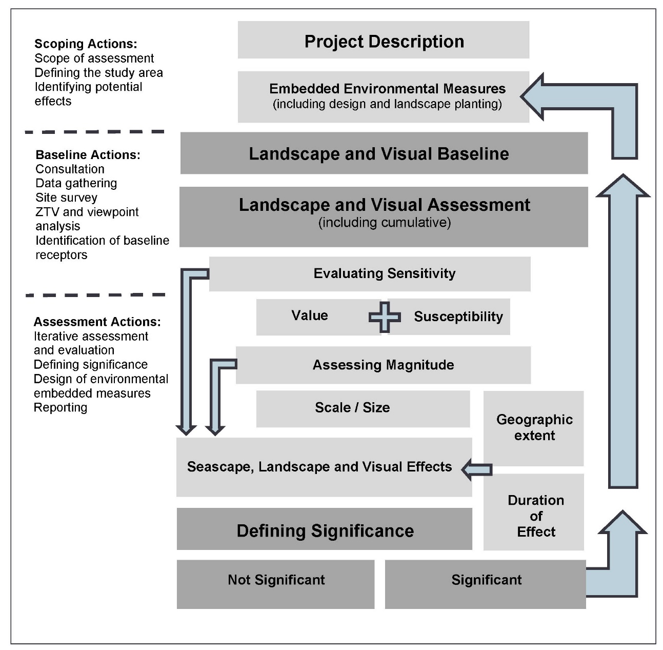
- An overview of the SLVIA process is provided here and illustrated, diagrammatically in Table 15.15 Open ▸ .
Table 15.15: Overview of approach to SLVIA
- The SLVIA assesses the likely effects that the construction, operation and decommissioning of the Proposed Development on the seascape, landscape and visual resource, encompassing effects on seascape/landscape character, designated landscapes, visual effects and cumulative effects.
- An appropriate and proportionate level of assessment has been undertaken and agreed through consultation at the scoping stage. The level of assessment may be ‘preliminary’ (requiring desk-based data analysis) or ‘detailed’ (requiring site surveys and investigations in addition to desk-based analysis).
- For those matters ‘scoped in’ for assessment ( Table 15.13 Open ▸ ), the approach to level of assessment is tiered. A ‘preliminary’ or ‘detailed’ assessment is undertaken as follows:
- a ‘preliminary assessment’ approach for an environmental aspect / effect which may include secondary baseline data collection (for example desk-based information) and qualitative assessment methodologies. Preliminary assessments are set out in Table 15.19 Open ▸ (Representative Viewpoints) Table 15.20 Open ▸ (visual receptors) and Table 15.26 Open ▸ . The preliminary assessment identifies which seascape, landscape and visual receptors are unlikely to be significantly affected, which are subject to a preliminary assessment, and those receptors that are more likely to be significantly affected by the Proposed Development, which require a ‘detailed assessment’; and
- a ‘detailed assessment’ approach is undertaken for seascape, landscape and visual receptors/effects that are identified in the preliminary assessment as requiring detailed assessment, based on evaluation of receptor sensitivity, likely magnitude of change and geographic extent of effects, with reference to the ZTV analysis (Figure 15.5 to Figure 15.13). This detailed assessment, presented in Section 15.11, may include primary baseline data collection (for example through site surveys), quantitative and qualitative assessment methodologies, and modelling such as ZTV analysis (Figure 15.5 to Figure 15.13) and wireline/photomontage visualisations (Figure 15.21 to Figure 15.75).
- The assessment of whether an effect has the potential to be of likely significance has been based upon review of existing evidence base, consideration of commitments made (embedded environmental measures), professional judgement, evaluation of sensitivity of the receptor and magnitude of change, and where relevant, recommended aspect specific methodologies and best practice.
- To ensure the provision of a proportionate EIA Report that is focused on likely significant effects, the assessment takes into account the considerable levels of existing environmental information available, extensive local geographical knowledge and understanding of the site and surroundings gained from site selection analysis and environmental surveys.
- The seascape, landscape and visual assessment unavoidably, involves a combination of quantitative and qualitative assessment and wherever possible a consensus of professional opinion has been sought through consultation, internal peer review, and the adoption of a systematic, impartial, and professional approach.
15.9.3. Impact Assessment Criteria
Defining impact significance
- The seascape, landscape and visual effects (and whether they are significant) is determined by an assessment of the 'sensitivity' of each receptor or group of receptors and the 'magnitude of change' that would result from the Proposed Development.
- The evaluation of sensitivity takes account of the value and susceptibility of the receptor to the Proposed Development. This is combined with an assessment of the magnitude of change which takes account of the size and scale of the proposed change. By combining assessments of sensitivity and magnitude of change, a level of seascape, landscape or visual effect can be evaluated and determined. The resulting level of effect is described in terms of whether it is significant or not significant, and the geographical extent, duration and the type of effect is described as either direct or indirect; temporary or permanent; reversible; cumulative; and beneficial, neutral or adverse.
Sensitivity
- The sensitivity of seascape, landscape and visual receptors is an expression of the combination of the judgements made about the value of that receptor and its susceptibility to the specific type of change or the development proposed. Landscape value is the ‘inherent’ component, which is independent of the development proposal, while the other component, susceptibility, is development specific.
- The value of a seascape, landscape or view receptor is a reflection of the value that society attaches to that seascape, landscape or view. There are a range of factors that are used to establish value but the presence of designations at national or local levels often reflects the level of value or importance they signify to society. The range of factors that can be considered when identifying landscape value include natural heritage, cultural heritage, landscape condition, associations, distinctiveness, recreational, perceptual (scenic), perceptual (wildness and tranquillity) and functional factors (Landscape Institute, 2021).
- The susceptibility of a seascape or landscape to change is a reflection of its ability to accommodate the changes that may occur as a result of the addition of the Proposed Development, based on its characteristics, robustness, scale, topography, openness/enclosure, perceptual qualities and the associations between the landscape/seascape receptor and the Proposed Development. The susceptibility of visual receptors (people) relates mainly to the activity of the viewer (residents, motorists, walkers etc); the experience of the viewer - the extent to which attention or interest may be focused on the view and visual amenity; and the visual relationship between the receptors and the Proposed Development which combine to influence how susceptible viewers are to the potential effects of the Proposed Development.
- An overall assessment of the sensitivity of each seascape, landscape and visual receptor has been made by combining the assessment of the value of the receptor and its susceptibility to change. In SLVIA, sensitivity is specific to the Proposed Development and to the location in question. An overall level of sensitivity has been applied for each visual receptor or view – high, medium-high, medium, medium-low or low. These levels are not defined as such, however the basis for sensitivity assessments has been made clear using evidence and professional judgement in the evaluation of each receptor, with reference to criteria that tend towards higher or lower sensitivity levels as set out in Technical Appendix 15.1: SLVIA Methodology.
Magnitude
- The magnitude of change affecting seascape, landscape and visual receptors is an expression of the scale of the change that will result from the Proposed Development and is dependent on a number of variables regarding the size or scale of the change that will arise as a result of the Proposed Development. The geographic extent over which the change will be experienced is also assessed, which is distinct from the size or scale of change. The criteria for defining magnitude in this chapter are outlined in Table 15.16 Open ▸ below.
Table 15.16: Definition of Terms Relating to the Magnitude of an Impact
Significance of Effect
- Information about the Proposed Development and the proposed activities with all stages of the Proposed Development life cycle (construction, operation and maintenance, and decommissioning) is combined with information about the environmental baseline to identify the potential interactions between the Proposed Development and the environment.
- These potential interactions are known as potential impacts. The potential impacts are then assessed for the level of significance of their effect on the receiving environment/receptors.
- To ensure consistency across the team of Offshore EIA Report authors, the terms impact and effect are defined below. The definitions are based on the glossary of the Highways Agency Design Manual for Roads and Bridges (DMRB) (2008):
- Impact: Change that is caused by an action. Impacts can be defined as direct, indirect, temporary, irreversible, secondary, cumulative and inter-related. They can also be either positive or negative, although the relationship between them is not always straightforward; and
- Effect: Term used to express the consequence of an impact (expressed as the 'significance of effect'), which is determined by correlating the magnitude of the impact to the importance, or sensitivity, of the receptor or resource in accordance with defined significance criteria. For example, using the inter-array cable laying example again, the laying of an inter-array cable (action) results in seabed disturbance (impact), with the potential to disturb benthic habitats and species (effect).
- The outcome of the assessment is the determination of the significance of these effects against predetermined criteria.
- The process for determining the significance of effects is a two-stage process that involves defining the magnitude of the potential impacts and the sensitivity of the receptors. This section describes the criteria applied in this chapter to assign values to the magnitude of potential impacts and the sensitivity of the receptors. The terms used to define magnitude and sensitivity are based on those which are described in further detail in volume 1, chapter 6 of the Offshore EIA Report.
- The significance of the effect upon seascape, landscape and visual receptors is determined by correlating the magnitude of the impact and the sensitivity of the receptor. The particular method employed for this assessment is presented in Table 15.17 Open ▸ .
- The significance of the effect on each seascape/landscape character and visual receptor is dependent on all of the factors considered in the sensitivity of the receptor and the magnitude of change resulting from the Proposed Development. Factors which influence levels of sensitivity and magnitude of change assessed in the SLVIA are set out in full in Technical Appendix 15.1: SLVIA Methodology. Judgements on sensitivity and magnitude of change are combined to arrive at an overall assessment as to whether the Proposed Development will have an effect that is significant or not significant on each seascape/ landscape and visual receptor.
- The matrix in Table 15.17 Open ▸ is used as a guide to help inform the threshold of significance when combining sensitivity and magnitude to assess significance. On this basis potential impacts are assessed as of negligible, minor, moderate and major. In those instances where there would be no effect, the magnitude has been recorded as ‘Zero’ and the level of effect as ‘None’.
- For the purposes of this assessment, any effects with a significance level of major and major/moderate have been deemed significant in EIA terms (dark shaded boxed in Table 15.17 Open ▸ ). ‘Moderate’ levels of effect (indicated in grey in Table 15.17 Open ▸ ) have the potential, subject to the assessor’s professional judgement, to be considered as significant or not significant, depending on the sensitivity and magnitude of change factors evaluated. These assessments are explained as part of the assessment, where they occur.
- Significance can therefore occur at a range of levels depending on the magnitude and sensitivity, however in all cases, a significant effect is considered more likely to occur where a combination of the variables results in the Proposed Development having a defining effect on the landscape/seascape character or view. Definitions are not provided for the individual categories of significance shown in the matrix and the reader should refer to the detailed definitions provided for the factors that combine to inform sensitivity and magnitude. Effects assessed as being either moderate/minor, minor, minor/negligible or negligible level are assessed as non-significant (light shaded boxes in Table 15.17 Open ▸ ).
- In line with the emphasis placed in GLVIA3 upon the application of professional judgement, an overly mechanistic reliance upon a matrix is avoided through the provision of clear and accessible narrative explanations of the rationale underlying the assessment made for each landscape and visual receptor.
Table 15.17: Matrix Used for the Assessment of the Significance of the Effect
Geographical extent
- The geographic extent over which the seascape/landscape and visual effects will be experienced is also assessed, which is distinct from the size or scale of effect. This evaluation is not combined in the assessment of the level of magnitude, but instead expresses the extent of the receptor that will experience a particular magnitude of change and therefore the geographical extents of the significant and not significant effects. The geographic extent of the effects varies depending on the specific nature of the Proposed Development and is principally assessed through analysis of the extent of perceived changes through visibility of the Proposed Development using the ZTV (Figure 15.5 and Figure 15.6) and field survey verification.
Duration and reversibility
- The duration and reversibility of seascape, landscape and visual effects is based on the period over which the Proposed Development is likely to exist and the extent to which it will be removed and its effects reversed at the end of that period. OPEN’s methodology does not include duration and reversibility as part of magnitude of change, as there is potential that the reversibility aspect could alter or reduce potentially significant effects even though they are long-term. The duration and reversibility of the effects is instead determined separately in relation to the assessed effects.
- Long-term, medium-term and short-term seascape/ landscape effects are defined as follows:
- long-term – more than 10 years;
- medium-term – 6 to 10 years; and
- short-term – 1 to 5 years.
- Duration and reversibility are not incorporated into the assessment of magnitude of change, but are stated separately in relation to the assessed effects (i.e. as short/medium/long-term and temporary/permanent) and are considered as part of drawing conclusions about significance, combining with other judgements on sensitivity and magnitude, to allow a final judgement to be made on whether each effect is significant or not significant.
Visibility
- The varied clarity or otherwise of the atmosphere will reduce the number of days (the ‘frequency’) upon which views of the Proposed Development will be available from the coastline and hinterland, and is likely to inhibit clear views, rendering the Proposed Development wind turbines located at long distance offshore, as visually recessive within the wider seascape. The effects of the construction and operation of the offshore infrastructure will vary according to the weather and prevailing visibility. This means that effects that are may be significant in the SLVIA under ‘very good’ or ‘excellent’ (i.e., worst-case/optimum) visibility conditions, may be not significant under moderate, poor or very poor visibility conditions.
- Assessments are based on a worst-case position of optimum (‘very good’ or ‘excellent’) visibility, in line with current guidance (Landscape Institute and IEMA, 2013), however within the visual assessment there is an assessment of the frequency or ‘likelihood’ of effect’ for each viewpoint, based on the distance of the Proposed Development, Met Office visibility data and professional judgement based on experience of viewing offshore wind farms in different conditions and distances. Likely visibility frequency can therefore been taken into consideration, with visibility range from viewpoints located at very long distances over 40km (where ‘excellent’ visibility is required) occurring less frequently than viewpoints at closer range.
View Range
- In assessing the visual effects of the Proposed Development, the distance between the Proposed Development and the relevant visual receptor is described as being short-range, mid-range, long range or very long range, which are defined as follows:
- very long range - over 40 km;
- long range – 25 to 40 km;
- mid-range – 15 to 25 km; and
- short range – 0 to 15 km.
15.9.4. Visual Representations Methodology
- The methodology for the production of visual representations (photomontages and ZTVs) of the Proposed Development is set out in full in Technical Appendix 15.1: SLVIA Methodology.
- The visual representations presented in Figure 15.21 to Figure 15.75, have been produced in accordance with Visual Representation of Wind farms (NatureScot, 2017) and Visual Representation of Development Proposals (TGN 06/19) (Landscape Institute, 2019).
- The ZTVs in Figure 15.5 to Figure 15.13 have also been produced in line with guidance in Visual Representation of Wind farms (NatureScot, 2017) and are generated using GIS software (ESRI ArcGIS Version 10.5) to model the theoretical visibility of the Proposed Development.
- ZTVs and visual representations are produced on the assumption that the Proposed Development wind turbines are modelled relative to Lowest Astronomical Tide (LAT) sea level at their maximum blade tip height (355 m). The sea level for LAT is modelled at -2.27 m below Ordnance datum (OD), which is equivalent of LAT for the closest tidal station in Aberdeen. The height of LAT within the Proposed Development Array Area relative to mean sea level (MSL) is between -2.46 and -2.87 m.
- The photographs used in the photomontages shown in Figure 15.21 to Figure 15.75 were captured during October, November and December 2021; and January 2022 as described in Table 15.6 Open ▸ in excellent visibility conditions and show this maximum potential visibility of the Proposed Development. In reality the degree and extent of visual effects arising from the Proposed Development will be influenced by the prevailing weather and visibility conditions and such excellent visibility occurs relatively infrequently, as described in Section 15.7.2.
15.10. Measures Adopted as part of the Proposed Development
- As part of the project design process, a number of measures have been proposed to reduce the potential for impacts on seascape, landscape and visual receptors (see Table 15.18 Open ▸ ). As there is a commitment to implementing these measures, they are considered inherently part of the design of the Proposed Development and have therefore been considered in the assessment presented in Section 15.11 below (i.e. the determination of magnitude and therefore significance assumes implementation of these measures). These measures are considered standard industry practice for this type of development.
Table 15.18: Designed In Measures Adopted as Part of the Proposed Development
15.11. Assessment of Significance
Effects (daytime) of the construction and decommissioning of the offshore ELEMENTS ON visual receptors/views
- The Proposed Development will have impacts on visual receptors/views during construction and decommissioning phases (as indicated in Table 15.13 Open ▸ ).
- Construction and decommissioning phase effects on visual amenity will occur as a result of the activities, including laying offshore export cables to shore; installation of wind turbines and OSPs; use of service vessels and partially constructed/decommissioned offshore elements, all of which may combine to alter the visual amenity through visibility of the construction and decommissioning activities.
- The residual effects arising as a result of the construction and decommissioning of the Proposed Development are assessed as being of the same or lower magnitude and significance on all visual receptors and viewpoints as those arising due to their operation and maintenance, however the residual effects are assessed as being short-term and temporary, occurring during the length of the construction and decommissioning phase, and differing in nature from the operational effects mainly due to the influence of the various construction vessels in the seascape, including cable laying vessels closer to shore within the export cable array area corridor, that will not be present or result in effects during the operational phase. During the majority of the construction and decommissioning phases the magnitude of change and effects on visual receptors/views will be less than during the operational phase, while the wind turbines are not fully constructed.
Effects (daytime) of the construction and decommissioning of the offshore elements of the Proposed Development on seascape (COASTAL) character
- The Proposed Development will have impacts on perceived seascape character during construction and decommissioning phases (as indicated in Table 15.13 Open ▸ ).
- Construction and decommissioning phase effects on seascape (coastal) character will occur as a result of the construction activities, including laying new offshore export cables to shore; the construction phase for the installation of and wind turbines; windfarm service vessels and partially constructed offshore elements; all of which may combine to alter the visual amenity and seascape character through visibility of the construction and decommissioning activities.
- The residual effects arising as a result of the construction and decommissioning of the Proposed Development are assessed as being of the same magnitude and significance on all seascape receptors as those arising due to their operation and maintenance, with the residual effects being short-term and temporary, occurring during the length of the construction and decommissioning phase and differing in nature from the operational effects mainly due the influence of the various construction vessels in the seascape, including cable laying vessels closer to shore within the export cable array area corridor, that will not be present or result in effects during the operational phase. During the majority of the construction and decommissioning phases the magnitude of change and effects on coastal character will be less than during the operational phase, while the wind turbines are not fully constructed.
Effects (daytime) of the construction and decommissioning of the offshore elements of the Proposed Development on perceived landscape character/special qualities of designated landscapes
- The Proposed Development will have impacts on perceived landscape character/special qualities during construction and decommissioning phases (as indicated in Table 15.13 Open ▸ ).
- Construction and decommissioning phase effects on perceived landscape character will occur as a result of the construction activities, including laying new offshore export cables to shore; the construction phase for the installation of wind turbines; windfarm service vessels; and partially constructed offshore elements; all of which may combine to alter the perceived landscape character through visibility of the construction and decommissioning activities.
- The residual effects arising as a result of the construction and decommissioning of the Proposed Development are assessed as being of the same magnitude and significance on all landscape receptors as those arising due to their operation and maintenance, with the residual effects being short-term and temporary, occurring during the length of the construction and decommissioning phase and differing in nature from the operational effects mainly due the influence of the various construction vessels in the seascape, including cable laying vessels closer to shore within the export cable array area corridor, that will not be present or result in effects during the operational phase. During the majority of the construction and decommissioning phases the magnitude of change and effects will be less than during the operational phase, while the wind turbines are not fully constructed.
- The Proposed Development will have impacts on visual receptors/views during the operation and maintenance phase (as indicated in Table 15.13 Open ▸ ).