

UNITS
Definition | |
dB(A) | Decibels measured on a sound level meter incorporating a frequency weighting (A weighting) which differentiates between sounds of different frequency (pitch) in a similar way to the human ear. Measurements in dB(A) broadly agree with people’s assessment of loudness. |
GW | Gigawatts |
Hz | Is the derived unit of frequency in the International System of Units (SI) and is defined as one cycle per second |
km | Kilometre |
m | Metre |
MW | Mega Watt |
µg/m3 | Ambient concentration of a pollutant in micrograms per cubic metre |
ha | Hectare |
GLOSSARY
Term | Definition |
|---|---|
Trenchless technology | Trenchless technology is a type of subsurface construction work which can be completed without the need for continuous open trenches. The operation can be completed using a number of methods, materials and equipment capable of installing new below ground cabling with minimal disruption to the at-surface infrastructure or activities. Some examples of this construction method include Horizontal Direction Drilling (HDD), Pipe Thrusting and Micro-tunnelling. |
Open Cut Trenching (on land) | Open cut trenching is a traditional method of cable installation. On land it requires opening up the surface of the ground through excavation to the required depth to lay the cable. Following installation, the trench will be backfilled and land that is used for temporary access will be restored. |
Open Cut Trenching (at landfall(s)) | Open cut trenching at the landfall(s) location would follow the method described above but also require temporary sheet pile walls allowing the opening of a trench through unstable wet beach sands. Across the nearshore, high-energy littoral zone, shallow water dredging techniques would be employed. Once sufficient depth is reached, submerged trenching equipment will take over. |
High Voltage Direct Current (HVDC) | High Voltage Direct Current (HVDC) is used to transmit power from offshore substations to onshore substations. HVDC systems use direct current for the transmission of electrical power, using converters at the offshore substation to converter AC power generated by the WTG to DC, and returning the power to AC at the onshore substation for connection to the AC transmission grid. |
High Voltage Alternating Current (HVAC) | High Voltage Alternating Current (HVAC) is used to transmit power from the offshore substation to the onshore substations. HVAC systems use alternating current for the transmission of electrical power, increasing the voltage of the AC power generated by the WTG’s to a higher voltage to allow efficient transmission over long distances and connection to at the transmission system. |
Search Area for the Site Boundary | Due to ongoing investigations, the Proposed Development site boundary cannot be defined at the time of reporting. Therefore, a Search Area for the Site Boundary has been defined. No infrastructure will be located outwith this area. For the purposes of scoping the Environmental Impact Assessment, this Search Area has been used for the identification of receptors which are considered to have potential to be impacted by the Proposed Development. |
Planning Application Boundary | The Proposed Development site boundary which will be finalised with submission of the EIA and will encompass the boundary of the land to be developed. |
- INTRODUCTION
- Background
Background
INTRODUCTION Background
In 2009 Seagreen Wind Energy Limited (“Seagreen”) was awarded development rights to R3 Zone 2 (named ‘Firth of Forth Zone’), and subsequently Seagreen and the Crown Estate entered into a Zone Development Agreement (ZDA) with a target Zone generation capacity of circa 3.5 gigawatts (GW).
The ZDA granted Seagreen certain seabed rights within the Zone, such as to identify specific areas for the development of offshore wind farms. Although the boundary of the Zone was fixed, development phase and project boundaries remained flexible within the Zone.
Seagreen opted for a phased approach to the delivery of the projects within the Zone to achieve the target capacity of around 3.2 GW. This approach involved prioritising areas considered to have the least potential constraints and considering the practicalities of resourcing delivery of the target capacity for the Zone. To support the definition of Phases and Project boundaries rationally and strategically, Seagreen adopted the Zone Appraisal and Planning (ZAP) approach.
Sites were ranked on the level of constraint and ability to construct. Phase 1, Phase 2 and Phase 3 project boundaries were developed. The Phase 1 projects consist of Project Alpha and Project Bravo laterally Seagreen Offshore Wind Farm which was awarded consent in November 2017 for 1.5 GW, with construction commencing in 2020. Phase 2 projects of the Firth of Forth Zone consists of Project Charlie, now Berwick Bank Wind Farm, and Project Delta, now Marr Bank Wind Farm, which could generate a combined potential of around 3.2 GW of renewable electricity.
The Applicant is now proposing to take forward the second area (Berwick Bank Wind Farm, formerly named Seagreen 2 and hereafter referred to as “the Project”) and apply for 50 year consent required to build, operate and decommission the offshore and onshore infrastructure. This document is the Environmental Impact Assessment (EIA) Scoping Report for the proposed Onshore Transmission Works (OnTW) associated with Berwick Bank Wind Farm (hereafter referred to as “the Proposed Development”).
A separate EIA scoping exercise is being progressed in respect of offshore elements of the Project (“the offshore works”). Responsibility for that scoping response lies with Marine Scotland, with ELC a statutory consultee in the process.
For the purpose of EIA, the following distinctions are made:
- The Proposed Development, which is the subject of the onshore EIA to which this scoping request relates to the OnTW elements of the Project located above (i.e. on landward side of) Mean Low Water Springs (MLWS);
- The offshore works, which are covered in the offshore EIA, which is the subject of the aforementioned separate scoping request to Marine Scotland – elements of the Project located below (i.e. of the seaward side of) Mean High Water Springs (MHWS); and
- It is acknowledged that this approach creates a theoretical and potentially practical area of overlap between the two EIAs, i.e. the “inter-tidal” area between MLWS and MHWS. This is considered appropriate given the identical overlap between the two respective consenting regimes.
- The Applicant
The Applicant
Berwick Bank Wind Limited is a wholly owned subsidiary of SSE Renewables Developments (UK) Limited (“SSE Renewables”). Berwick Bank Wind Limited (BBWL) is the Applicant.
SSE Renewables is a leading developer, owner and operator of renewable energy across the UK and Ireland, with a portfolio of around 4GW of onshore wind, offshore wind and hydro. Part of the FTSE-listed SSE plc, its strategy is to drive the transition to a net zero future through the world class development, construction and operation of renewable energy assets.
1.3. The Consultant
ITPEnergised (here after referred to as “ITPE”) has been appointed by the Applicant as the Project Manager for EIA on the Proposed Development. In addition to the preparation of the EIAR, ITPE will undertake the ecology and ornithology, geology, hydrology and flood risk, noise, air quality, land use, and tourism assessments. ITPE will be supported by the following specialists:
- OPEN – landscape and visual;
- Cundall – traffic and transport;
- RPS – socio-economics and intertidal ornithology surveys;
- CFA Archaeology – cultural heritage; and
- Young Planning & Energy Consenting – planning and policy.
- Project and Proposed Development Overview
- The Project
Project and Proposed Development Overview The Project
- Project and Proposed Development Overview
As per Section 1.1, the Project (Berwick Bank Wind Farm) comprises an offshore element[1] and an onshore element.
The Applicant proposes to submit two distinct packages of applications, one for the offshore infrastructure comprising applications for a Marine Licence and consent under Section 36 of the Electricity Act 1989 and a second, comprising a planning application for the Proposed Development under the Town and Country Planning (Scotland) Act 1997.
This approach has been discussed with ELC and details are provided in Annex B2, no feedback has been received to date.
1.4.2. The Proposed Development
The Proposed Development (the OnTW) comprises the following:
- a new wind farm onshore substation;
- up to two landfall locations;
- underground cable route connections between the landfall(s) and the new substation, and between the new substation and the grid connection substation, with the option of a short section of overhead line (OHL) (which may require a separate application under Section 37 of the Electricity Act 1989); and
- associated ancillary infrastructure.
The Proposed Development comprises the onshore elements of the Project, i.e. the infrastructure located above MLWS. The Search Area for the Site Boundary for the Proposed Development is shown in Figure 1.1 and facilitates options for landfall location(s), substation sites and connecting cables. The Search Area for the Site Boundary will be refined and its exact size will be subject to an iterative process informed by environmental and geo-technical surveys to identify the Planning Application Boundary. Further details on this and the Proposed Development are provided in Chapter 5.
1.5. Purpose of Scoping Report
1.5.1. Screening
The Applicant proposes to apply to ELC for planning permission (under the Town and Country Planning (Scotland) Act 1997) to build and operate the Proposed Development.
EIA screening is the process by which it is determined whether or not an EIA should be undertaken for a proposed development and accompany the planning application.
The Proposed Development is considered to be a Schedule 2 development within The Town and Country Planning (Environmental Impact Assessment) (Scotland) Regulations 2017 (as amended) (hereafter referred to as the “2017 EIA Regulations”). Schedule 3 of the 2017 EIA Regulations sets out the criteria that should be considered in determining whether a development is likely to have significant environmental effects and hence require a formal EIA. These criteria are:
- the characteristics of the development (e.g. its size, culmination with other developments, use of natural resources, resultant pollution, waste generated);
- the environmental sensitivity of the location; and
- the characteristics of the potential impacts (including extent, magnitude, probability and duration).
A formal screening opinion has not been sought from ELC. In considering the criteria set out in Schedule 3, the Applicant accepts that an EIA should be undertaken for the Proposed Development.
1.5.2. Scoping
Regulation 17 of the 2017 EIA Regulations provides for potential applicants to ask the planning authority to state in writing the information that ought to be provided within the EIAR. The ‘Scoping Opinion’ is to be offered following discussion with the consultation bodies.
The Applicant recognises the value of the Scoping approach and the purpose of this report is to ensure that relevant issues are identified, and to confirm that the assessment process intended will meet legislative requirements.
This Scoping Report provides a description of the known environmental baseline, identifies additional surveys or studies required to confirm the baseline, describes the proposed methodology of the assessment of effects, and determines what receptors and/or impacts can be scoped out of the EIA.
1.6. Onshore Scoping Report Structure
This report is structured as follows:
- EIA scoping approach;
- Planned consultation and stakeholder engagement;
- Overview of the relevant policy and legislation;
- Overview of site section process;
- Proposed Development description;
- The proposed generic methodology for the assessment of effects;
- A description of each environmental topic, including baseline information, study area, embedded mitigation, potential effects and cumulative effects, receptors and impacts scoped out of further assessment and key queries to consultees; and
- A summary of this Onshore EIA Scoping Report.
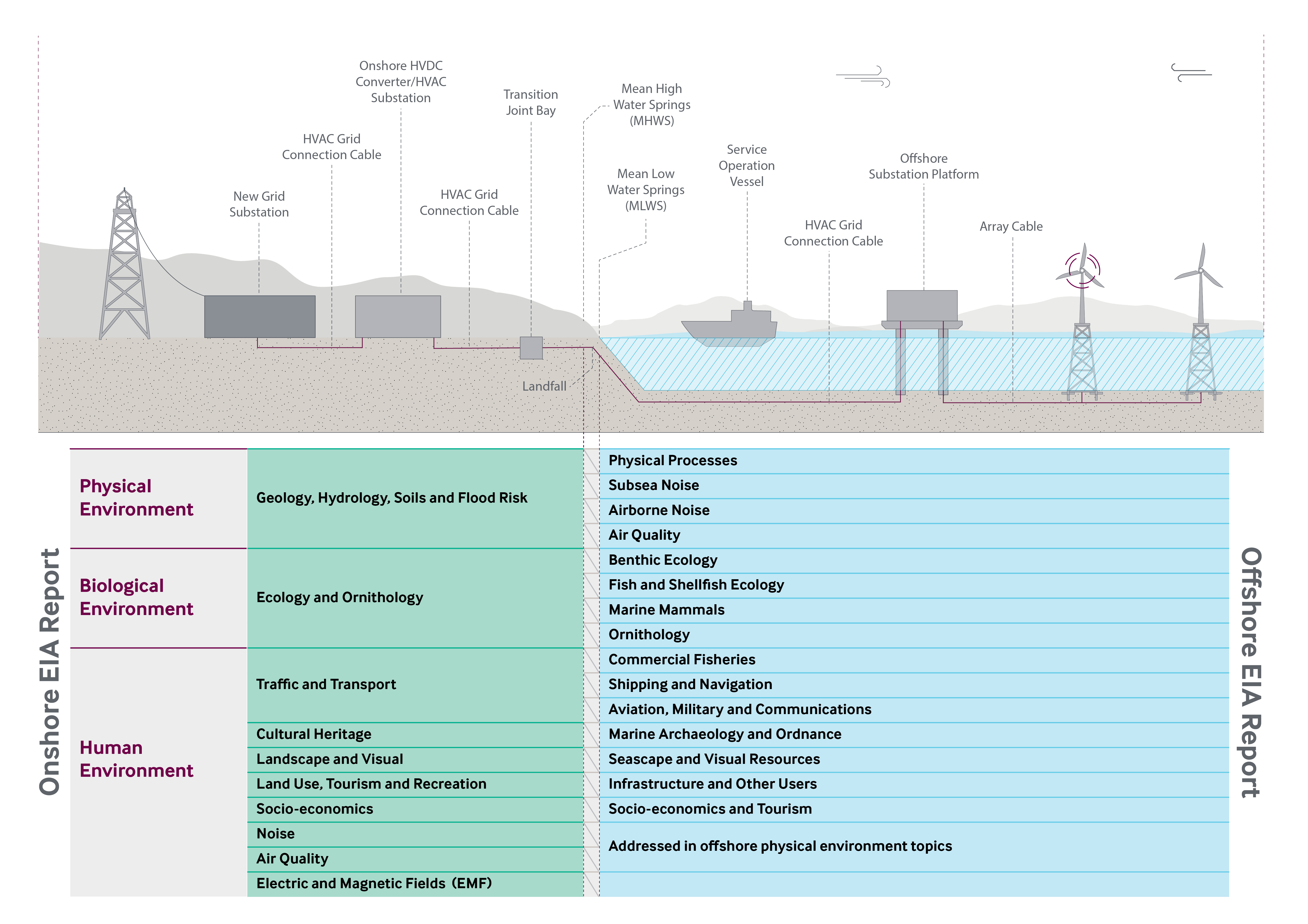
As per Section 1.1 above, a separate Offshore EIA Scoping Report (and associated Offshore EIAR) relating to offshore infrastructure will be submitted in support of the offshore Proposed Development consent Application. Where there is an overlap in jurisdiction in the intertidal area between MHWS and MLWS of the onshore and offshore consenting and regulatory regimes, both the Onshore Scoping Report and the Offshore Scoping Report presents the relevant technical assessments (refer to Diagram 1.1).
1.7. References
- Scottish Executive (1997). The Town and Country Planning (Scotland) Act 1997. Available at: http://www.legislation.gov.uk/ukpga/1997/8/contents
- Scottish Government (2017). The Town and Country Planning (Environmental Impact Assessment) (Scotland) Regulations 2019. Available at: http://www.legislation.gov.uk/ssi/2017/102/contents/made
- EIA SCOPING APPROACH
- Introduction
Introduction
EIA SCOPING APPROACH Introduction
This chapter details how the Applicant has approached the scoping of the EIAR.
2.2. Approach to Scoping
The Applicant is undertaking a comprehensive site selection process, identifying the most suitable landfall(s), substation and cable route locations from a range of environmental, engineering and land perspectives. The site selection process will be completed following more detailed assessments by the Applicant, due to be undertaken at the time of submission of this Scoping Report. Therefore, this Scoping Report considers the siting of the Proposed Development within the Search Area for the Site Boundary identified on Figure 1.1, including three potential substation locations and two potential landfall options (refer to Chapter 5 for further details).
2.2.1. The Town and Country Planning (Environmental Impact Assessment) (Scotland) Regulations 2017
As per Section 1.5, the Applicant has opted to undertake an EIA on a voluntary basis.
In accordance with Regulation 17(2) the “scoping request” of which this EIA Scoping Report is part includes:
- “a description of the location of the development, including a plan sufficient to identify the land” – identified in Chapter 5 and Figure 1.1;
- “a brief description of the nature and purpose of the development and of its likely significant effects on the environment” – provided in Chapter 6 and Chapters 7-16 of this Scoping Report;
- “such other information or representations as the developer may wish to provide or make”.
In forming a scoping opinion, Regulation 17(5) requires the planning authority to take into account “the information provided by the developer, in particular information provided by the developer in respect of the specific characteristics of the development, including its location and technical capacity and its likely impact on the environment”.
The Applicant has proposed a scope of EIA which is proportionate, reasonable, and takes account of the above mentioned points. This proposed scope is summarised in Chapter 17 of this Scoping Report.
2.2.2. Study Areas
The study areas to be assessed by the technical disciplines are different depending on each discipline and their receptors. However, all are based on the Search Area for the Site Boundary shown in Figure 1.1 As described above, the final site boundary will be within this Search Area and will be confirmed prior to the final EIA assessment of the Proposed Development.
2.2.3. Baseline Environment
To appropriately scope the EIA, each technical discipline has identified their study area. Each technical assessor has described, where possible, their environmental baseline, the characteristics/nature of the receiving environment and receptors. This information has been gathered from desk-studies and publicly available information.
Where there are aspects of the baseline which are unknown, the Scoping Report identifies the surveys and /or studies proposed to be undertaken to provide this information. Although some of these surveys have commenced at the time of the submission, COVID-19 restrictions have meant that the majority of these have not yet commenced.
2.2.4. Assessment
The Applicant is a keen supporter of a proportionate EIA (IEMA, 2017). A proportionate EIA is one which has been scoped to focus on the potential significant adverse environmental effects. It scopes out receptors which would not be impacted by the Proposed Development or impacts which we can confidently predict will not result in significant adverse effects.
2.2.5. Application of Embedded Measures
In order to ensure a proportionate EIA this Scoping Report assumes that a range of mitigation measures will be embedded within the Proposed Development. These mitigation measures will be undertaken by the Applicant, no matter the findings of the EIA, or whether or not the measures are specifically required by the planning permission, and are therefore part of the Proposed Development, rather than in addition to the Proposed Development.
Annex A provides an Outline Schedule of Environmental Commitments (OSEC). This OSEC details all the embedded mitigation measures and will be expanded upon based on the findings of the EIA.
When considering the potential significance of the effects due to the Proposed Development, the EIA Scoping Report takes into consideration the mitigation measures described in the OSEC. Therefore, receptors and impacts are only proposed to be taken forwards for further assessment within the EIA if it is considered that there is potential for significant effects to arise even with the implementation of the OSEC.
2.2.6. Approach to Scoping of Cumulative Impacts
The cumulative assessment of the Proposed Development will be two-tiered:
- Tier 1 - An assessment of the cumulative effects where there is potential for onshore receptors to be affected by the onshore and offshore infrastructure of the Project; and
- Tier 2 - An assessment of the cumulative effects of the Project in combination with other proposed (in planning) and consented developments in the onshore environment.
. As per Scottish Planning Policy (Scottish Government, 2014) only developments which are submitted to planning, consented or under construction will be considered cumulatively. Developments which have not yet submitted a planning application (i.e. developments who are at Scoping or have submitted a Proposal of Application Notice) will not be included within the cumulative assessment due to the lack of certainty over their design and potential environmental effects.
This list of cumulative developments will continually be updated throughout the assessment of the Proposed Development and any exceptional circumstances considered. However, the list will be “frozen” three months prior to the submission of the application to allow assessments to be made and reported within the EIAR.
The Applicant would be grateful if ELC would review this list and confirm if there any additional developments which they are aware of.
2.3. Community Consultation & Stakeholder Engagement
2.3.1. Regulatory Basis to Community Consultation
Since the Proposed Development falls within the scope of National Planning Framework (NPF) 3’s national development number 4, it is afforded national development status in accordance with the Town and Country Planning (Hierarchy of Developments) (Scotland) Regulations 2009. Such status requires applicants to engage with local communities during a formal pre-application consultation process triggered by the submission of a Proposal of Application Notice to the relevant planning authority. That pre-application process must then be documented within a Consultation Statement which forms part of the suite of planning application documentation. The Applicant confirms that these Regulatory obligations will be delivered as part of a comprehensive programme of pre-application consultation programmed for Q4 2020-Q2 2021.
2.3.2. Engagement to Date
The Applicant has undertaken early engagement with statutory consultees, ELC, Scottish Environment Protection Agency (SEPA), Scottish Natural Heritage (SNH) and Historic Environment Scotland (HES). This engagement has taken the form of introductory correspondence to identify the appropriate contact with the organisation and introductory meetings where the Applicant has provided the consultee with an overview of the Proposed Development, the background and the proposed timescales of the application. This has provided consultees with the opportunity to raise queries and provide feedback early in the application process.
Correspondence received from this engagement is provided for reference within Annex B.
2.3.3. Proposed Approach to Engagement
The Applicant proposes to continue to consult throughout the pre-application stage of the Proposed Development, following receipt of consultee comments as part of the EIA Scoping Opinion.
The Applicant’s technical team will contact consultees directly on matters of technical expertise, agreement of surveys, discussion of mitigation, etc. and all consultation will be reported fully within the EIAR.
2.3.4. Public Consultation
The Applicant will undertake a number of public exhibitions on the Project (including the Proposed Development), as well as meeting with the Community Councils to ensure the public is fully informed and that their views are considered in the design of the Proposed Development. If at the time of undertaking public exhibitions there is still a risk posed by COVID-19, then these will be carried out in accordance with relevant legislation, and may be held virtually (Scottish Government, 2020).
Details of the proposed approach to public consultation will be set out in the Pre-Application Notification (PAN) submitted to ELC.
Full details and outcomes of the public engagement will be provided within a Pre-Application Consultation Report which will be submitted in support of the planning application.
2.4. Application and Consenting Process
In defining an appropriate consenting strategy, the Applicant has drawn from a wide range of experience of comparable projects, both in East Lothian and elsewhere. The consenting strategy is underpinned by the Proposed Development’s national development status by way of NPF3’s national development 4, as well as NPF3’s identification of the Torness area as a hub for energy-related investment (refer to Chapter 3 for further details).
The Applicant has considered a series of potential consenting options. Marine Scotland advocates a streamlined “one stop shop” consenting process including ancillary onshore infrastructure associated with offshore generation being consented via a direction for deemed planning permission under S57 of the Town and Country Planning (Scotland) Act 1997 (as amended by the Growth and Infrastructure Act 2013) as part of a single application for consent under Section 36 of the Electricity Act 1989. Whilst the option of a single application for off- and onshore elements of the Project remains available to the Applicant, this is not the option the Applicant is currently proposing.
Instead, as previously discussed it is intended that separate offshore and onshore applications will be made to Marine Scotland and ELC, respectively, the latter being a single application for full planning permission, in accordance with the Town and Country Planning (Scotland) Act 1997. It is currently anticipated that the applications will be made in 2021.
2.5. References
- Institute of Environmental Management and Assessment (IEMA) (2017), Delivering Proportionate EIA – A Collaborative Strategy Enhancing UK Environmental Impact Assessment Practice. Available at: https://www.iema.net/policy/ia/proportionate-eia-guidance-2017.pdf
- Scottish Government (2020), Coronavirus (COVID-19): Planning Guidance of Pre-Application Consultations for Public Events. Available at: https://www.gov.scot/publications/coronavirus-covid-19-planning-guidance-on-pre-application-consultations-for-public-events/
- POLICY & LEGISLATION
- Introduction
Introduction
POLICY & LEGISLATION Introduction
This chapter provides an overview of the policy and legislation context for the Proposed Development. A detailed discussion and evaluation of relevant policies will be included within the Planning Statement which will be submitted in support of the planning application.
3.2. Legislative Context
3.2.1. The Town and Country Planning (Scotland) Act 1997 (as amended)
The consenting approach described within Section 2.4 is underpinned by Section 25(1) of the Town and Country Planning (Scotland) Act 1997 (as amended by the Town and Country Planning (Scotland) Act 2019) (Scottish Government, 2019), which states: “Where, in making any determination under the planning Acts, regard is to be had to the development plan, the determination is, unless material considerations indicate otherwise, to be made in accordance with that plan.”
In the case of the Proposed Development, the development plan, the parameters of which are defined by Section 24 of the Town and Country Planning (Scotland) Act 1997 (as amended by the Town and Country Planning (Scotland) Act 2019), comprises:
- NPF3 (Scottish Government, 2014a);
- “SESplan” Strategic Development Plan (The Strategic Development Planning Authority for Edinburgh and South East Scotland, 2013); and
- East Lothian Council Local Development Plan 2018 (East Lothian Council, 2018) (hereafter “the LDP”).
This chapter considers the statutory development plan and relevant other policy-based material considerations, the latter including:
- Emerging development plan policy, specifically:
- NPF4; and
- SESplan 2;
- Scottish planning policy and advice notes; and
- UK and Scottish energy policy.
- National Planning Framework
- NPF3
National Planning Framework NPF3
- National Planning Framework
Section 6 of NPF3 notes that national developments have been defined in recognition of their “need” in the delivery of the Scottish Government’s wider spatial strategy for Scotland. It continues within paragraph 6.1 by specifically noting that “…national development status establishes the need for a project…”.
With the need for national developments clearly established, the remainder of this section demonstrates the applicability of national development status to the Proposed Development, before summarising relevant parts of NPF3.
3.3.1.1. National Development Number 4
NPF3’s national development 4 relates to the high voltage electricity transmission network, specifically:
“a. new and/or upgraded onshore electricity transmission cabling of or in excess of 132 kilovolts, and supporting pylons.
b. new and/or upgraded onshore sub stations directly linked to electricity transmission cabling of or in excess of 132 kilovolts.
c. new and/or upgraded onshore converter stations directly linked to onshore and/or offshore electricity transmission cable(s) of or in excess of 132 kilovolts.
d. new and/or upgraded offshore electricity transmission cabling of or exceeding 132 kilovolts.”
Annex A to NPF3 confirms that planning applications for development within one or more classes listed in the aforementioned points a-d is designated as “national” for the purpose of the Section 26A of the Town and Country Planning (Scotland) Act 1997 (as amended) and the associated Town and Country Planning (Hierarchy of Developments) (Scotland) 2009.
In describing national development designations, Annex A to NPF3 includes the following statement of need in respect of national development number 4:
“These classes of development are needed to support the delivery of an enhanced high voltage electricity transmission grid which is vital in meeting national targets for electricity generation, statutory climate change targets, and security of energy supplies.”
The Proposed Development falls within the scope of national development number 4 by way of relating to:
- New onshore electricity transmission cabling in excess of 132 kilovolts (kV); and
- A new onshore substation directly linked to such cables (i.e. consistent with the aforementioned paragraph b).
As such, the Proposed Development will, in the forthcoming planning application, be afforded national development status.
3.3.1.2. Torness Area
The strategic importance of the Torness area is recognised elsewhere in NPF3:
- On page 14: “The Fife Energy Corridor, which extends from Methil to Longannet, has potential for significant investment in energy-related business development, as do the Cockenzie and Torness areas in East Lothian”;
- On page 29: as part of the area of East Lothian illustrated as being subject to the “High Voltage Energy (sic) Transmission Network” national development designation; and
- On page 39: “Cockenzie, and the Forth coast extending to Torness, is also a potentially important energy hub. There are significant plans for offshore wind to the east of the Firths of Forth and Tay. Proposals for grid connections for these projects are now emerging, requiring undersea cabling connecting with converter stations and substations…”
- NPF4
Given its relative infancy following the 30 April completion of the Scottish Government’s “Call for Ideas” process, the emerging NPF4 is of very limited weight at this stage. However, preparation of NPF4 is likely to have progressed by the anticipated time of planning application submission; it will be appropriately referenced and relevant weight will be applied to its content.
The Applicant has engaged in the NPF4 Call for Ideas process, recommending and requesting continued national development status for transmission-scale electricity infrastructure proposals, as well as continued recognition of the strategic importance of the Torness area as part of East Lothian’s energy coast.
3.4. Other Extant and Emerging Development Plan Policy
3.4.1. Strategic Development Plan
3.4.1.1. Status of Extant and Emerging Strategic Development Plans
As referenced above, SESplan retains status as part of the statutory development plan. However, SESplan is aged and pre-dates the approval of NPF3. Given the advanced stage of its successor, “SESplan2”, SESplan is considered to be of limited weight in respect of applications for national developments defined by NPF3. Further, it is likely that SESplan2 will have been formally adopted by summer 2021, removing any residual relevance of SESplan. As such, SESplan is not considered further and SESplan2 is considered from a strategic development planning perspective.
3.4.1.2. SESplan2
SESplan2 has reached an advanced stage in its preparation, having been submitted to Ministers for approval following the July 2018 conclusion of an examination process. Whilst the submission was rejected by Ministers, the reasons for that rejection are of no relevance to the Proposed Development. As such, SESplan2, as it relates to matters of relevance to the Proposed Development, can be considered acceptable to Ministers. SESplan2 can therefore be considered representative of up-to-date strategic policy in respect of the Proposed Development, and significant weight can be attached to the Proposed SESplan2 (October 2016), incorporating the findings of Scottish Government Reporters, dated 20 July 2018.
Parts of relevance to the Proposed Development are outlined below, from SESplan2’s commentary on “A Low Carbon Economy”:
- Table 4.1: Significant Business Case – Torness identified as part of the “Forth Coast Cluster” a significant cluster area identified primarily for development associated with energy and port uses: “Cluster of coastal sites providing opportunities for a range of uses [including]…low carbon energy generation or other uses associated with Area of Coordinated Action…”; and
- In considering Table 4.1, Reporters consider that: “…the description of the principal sectors and opportunities associated with the Forth Coast Cluster within the proposed plan would encompass supporting infrastructure including cables and substations for major offshore wind farm developments…”.
Although not in the form of specific policies, SESplan2 also compels planning authorities, through development planning processes (as opposed to from a development management perspective), to provide sufficient protections for the natural environment, protected cultural heritage features and local communities, as well as ensuring sufficient infrastructure is placed to deliver sustainable development.
3.4.2. The LDP
LDP policy can be considered in three parts:
- site specific policies;
- policies relevant given the nature of the Proposed Development; and
- general LDP policies.
Within the supporting documentation which will accompany the planning application, policies within parts 1 and 2 above will be addressed within the supporting Planning Statement, and generally relate to the principle of the Proposed Development, whilst for those within part 3 above, forms part of the technical EIA assessment. LDP policies are outlined on these three bases, below.
3.4.2.1. Site Specific Policies
The Search Area for the Site Boundary (as described within Section 5.2) includes areas covered by the policy designations referenced within Table 3.1.
Table 3.1: Policy Designations
As previously noted, the Search Area for the Site Boundary will be refined through further design work and it may be that some of the designations are not relevant to the final form of the Proposed Development which progressed to planning application stage. Relevant site specific policies will be considered within the Planning Statement which accompanies the planning application and will form part of the detailed assessment within the relevant EIAR technical chapter.
3.4.2.2. Policies Relevant Specifically to the Proposed Development
In addition to relevant site specific policies, a small number of LDP policies are specific to proposals of character similar to the Proposed Development:
- Policy EGT4: Enhanced High Voltage Electricity Transmission Network.
Policy EGT4 outlines ELC support for development within the scope of NPF3’s national development number 4, subject to acceptable impacts on:
- landscape;
- visual amenity;
- communities;
- natural heritage; and
- cultural heritage.
Policy NGT4 also references Strategy Diagram 3, which illustrates the area of co-ordinated action and identifies “potential electricity grid connection” nearby Torness, as well as the Branxton sealing end compound within the area of co-ordinated action.
3.4.2.3. General LDP Policies
Of the LDP policies which are theoretically relevant to all planning applications, those referenced in Table 3.2 are relevant, or potentially could be relevant, to the consideration of the Proposed Development.
Table 3.2: Relevant LDP Policies
Relevant policies will form part of the assessment of the Proposed Development within the relevant EIAR technical chapter.
3.5. Other Policy-Based Material Considerations
3.5.1. Scottish Energy Policy
3.5.1.1. Scotland’s Emission Reduction Targets
The Climate Change (Emissions Reduction Targets) (Scotland) Act 2019 (Scottish Government, 2019a) sets targets for the reduction of greenhouse gases emissions. The objective is to contribute appropriately to the world’s efforts to deliver on the Paris Agreement reached at the 21st Conference of the Parties of the United Nations Framework Convention on Climate Change. The Emissions Reduction Targets include a reduction of all greenhouse gases to net-zero by 2045 at the latest, with interim targets for reductions of at least 56% by 2020, 75% by 2030 and 90% by 2040.
3.5.1.2. The Scottish Energy Strategy: The Future of Energy in Scotland
The Scottish Energy Strategy: The Future of Energy in Scotland (Scottish Government, 2017) sets out the Scottish Governments 2050 vision for energy in Scotland. One of the six 2050 vision includes renewable and low carbon solutions, specifically championing and exploring Scotland’s huge renewable energy resources and ability to support energy targets.
3.5.1.3. Draft Sectoral Marine Plan for Offshore Wind Energy
Scotland is committed to ensuring secure, reliable and affordable energy supplies, within the context of long-term decarbonised energy generation. In 2011, the first Sectoral Marine Plan for Offshore Wind Energy (Blue Seas Green Energy) (Marine Scotland, 2011) was adopted. In 2013, draft wind, wave and tidal plans were subsequently produced (Marine Scotland, 2013).
Building upon the work undertaken in the 2011 and 2013 plans, the Draft Sectoral Marine Plan for Offshore Wind Energy (Scottish Government, 2019b) incorporates recent technological, policy, regulatory and market developments to develop a new strategic planning process. This plan seeks to contribute to the achievement of Scottish and UK energy targets through the provision of a spatial strategy to inform the seabed leasing process for commercial offshore wind energy in Scottish waters, which:
- minimises the potential adverse effects on other marine users, economic sectors and the environment resulting from further commercial-scale offshore wind development; and
- maximises opportunities for economic development, investment and employment in Scotland, by identifying new opportunities for commercial scale offshore wind development, including deeper water wind technologies.
This plan identifies 17 draft plan options across five regions which are capable of generating several GW of renewable energy. There is the potential for up to 10 GW to be deployed to reflect the anticipated future demand and market appetite, exceeding the Scottish Offshore Wind Energy Council’s goal to deliver at least 8 GW of offshore wind in Scottish waters by 2030. The final Sectoral Marine Plan for Offshore Wind Energy will guide relevant consenting bodies with decision making on licence and consent applications but will not predetermine decision-making processes.
This plan has been developed in accordance with the strategic aims of the National Marine Plan (Marine Scotland, 2015a), which addresses the potential for interactions between renewable energy development and other marine users. The National Marine Plan also recognises that significant development of the offshore wind energy sector will require investment and improvement to the current electricity transmission and distribution systems, and efforts to reduce barrier connection costs for generators.
3.5.1.4. Draft Offshore Wind Policy Statement
The Draft Offshore Wind Energy Policy Statement (Scottish Government, 2019c) sets out ambitions to capitalise offshore wind development and the role this technology could play in meeting commitments of net zero by 2045, as required by The Climate Change (Emissions Reduction Targets) (Scotland) Act 2019. The Draft Offshore Wind Energy Policy Statement builds upon the ambitions outlined in Scotland’s Energy Strategy (Scottish Government, 2017), which sets out the 2050 energy vision. Scotland’s Energy Strategy forms a key component of the implementation of The Draft Offshore Wind Energy Policy Statement through the identification of suitable offshore wind farm development areas. The Draft Offshore Wind Energy Policy Statement is currently undergoing consultation and will be finalised in 2020.
3.5.2. Scottish Planning Policy and Advice Notes
Relevant sections of Scottish Planning Policy (SPP) (June 2014b) and relevant Planning Advice Notes (PANs) are summarised in Table 3.3, below, and are documented in respect of relevant environmental topics. Technical assessment of those environmental topics which are “scoped-in” to the EIA process will include consideration of the relevant parts of SPP and PANs.
Table 3.3: Summary of SPP and PANs
At paragraph 169, SPP sets out likely considerations to be taken into account in the determination of applications for renewable energy-related infrastructure. It acknowledges that the scope of considerations will be specific to the characteristics of specific proposals. Considerations of relevance to the Proposed Development are referenced within Table 3.3.
In addition to the topic specific PANs referenced in Table 3.3, PAN 1/2013: Environmental Impact Assessment (Scottish Government, 2013) is relevant to the forthcoming planning application, albeit elements are effectively outdated following the publication of the 2017 EIA Regulations.